Embed Size (px)
Citation preview

Name: _____________________________________ Pd. ______
World Atlas
For all maps, you must adhere to the following cartography rules:
Title at top of map page in dark, bold, black ink. (Must be big enough to stand out)
KeyAll required features must be labeled in black ink. (Except bodies of water)
All bodies of water (oceans, seas, straits, rivers, etc.) must be labeled with blue ink.
Use the maps throughout the assigned Units and the World Geography Atlas on pages A1–A25 to locate the features listed in each section
When a section of the atlas is due, you will turn in the following: A title page for that section of the atlas (Must be on unlined
paper and include images relevant to that specific region. Images of maps are NEVER acceptable)
A Rubric with your name, period, date, and section of the map information already filled out.
Political Features Physical FeaturesUsing colored pencils, make a dark outline of political boundaries (states/ countries/ territories)
Adjacent political entities must be different colors
Required plains must be colored greenRequired deserts must be colored yellow Mountains and required highlands & plateaus must colored brown.
Atlas Sections:Sections 1-9 # of
maps Due Date Sections 10-18 # of maps Due Date
Basics of Geography 3 Russia and the Republics 3
Physical Geography 2 Africa:Part 1 3
Regional Geography 2 Africa:Part 2 2
United States 2 Southwest Asia (Middle East) 3
Canada 2 South Asia:Part 1 2
Latin America: Part 1 2 South Asia:
Part 2 2
Latin America: Part 2 2 East Asia:
Part 1 2
Europe:Part 1 2 East Asia:
Part 2 2
Europe:Part 2 2 Southeast Asia,
Oceania, Antarctica 3
Your atlas is worth a test/project grade for the second 9wks and represents your skill in transferring information and ultimately, your capability. Neatness is a requirement and evidence of pride in your work is
expected. You will use this atlas on the semester exam as well.

Requirements for each map by Section:
Section 1 Map Title/ Unit Directions/ Features
Basics of Geography
Due Date:
World: PhysicalUnit 1
Physical maps represent the natural landscape of the earth. They show the earth’s relief (mountains, rivers, valleys, and plains) and other physical features.
Use the maps throughout Unit 1 and the World Geography Atlas on pages A1–A25 to locate the physical features listed below.
Complete the map by following the labeling and color-coding directions from the main pageOceans Continents Grid LinesArctic OceanAtlantic OceanIndian OceanPacific Ocean
AfricaAntarcticaAsia
AustraliaEuropeNorth AmericaSouth America
EquatorPrime meridianTropic of CancerTropic of Capricorn
Rivers MountainsAmazon RiverChang JiangCongo RiverDanube Euphrates River
Ganges RiverHuang HeMississippi RiverNile RiverTigris River
Andes MountainsAlpsAppalachian Mountains
HimalayasRocky MountainsUral MountainsIslandsGreenland
f
World: PoliticalUnit 1
Use the maps located in the World Geography Atlas on pages A1–A25, and throughout Unit 1 to locate the following countries, cities, and other features.
Complete the map by following the labeling and color-coding directions from the main pageBodies of Water RiversArctic OceanAtlantic OceanIndian OceanPacific Ocean
Amazon RiverChang Jiang Congo RiverDanube River
Euphrates RiverGanges RiverHuang He
Mississippi RiverNile RiverTigris River
Cities CountriesBangkok BeijingBuenos AiresCairoJakarta
Mexico CityMoscow New YorkParisRio de Janeiro
Kolkata (Calcutta)LondonLagos SydneyTokyo
ArgentinaCanadaChileEgyptFrance
Countries
New ZealandNorwayRussiaSaudi ArabiaSpainAustraliaColombiaChina
ItalyIranMadagascar United StatesSouth KoreaVenezuela EthiopiaGermany
IndiaJapanMexicoNigeriaPeruUnited KingdomSouth Africa Sweden
FinlandIcelandIndonesiaKazakhstanMongoliaNorth KoreaPolandBrazilDem. Rep. of Congo
f
World: Time Zones
Unit 1
Label which parts of the world are on Monday and which are on Sunday On the back of this map, answer the following questions in COMPLETE sentences:
1. How many time zones are there in the continental United States?2. If it is 1500 hours in El Paso, Texas, what is the time in Greenwich, England?3. If it is 0600 hours Sunday in New York, what are the day and time in Auckland, NZ?
Section 2 Map Title/ Unit Directions/ FeaturesPhysical
Geography
Due Date:
World: Climate Zones NEATLY color to differentiate the climate zones and include a key
Global Ocean CurrentsUnit 1
Ocean currents move in large circular systems and affect the temperature and precipitation patterns around the world.
Use the maps located throughout Unit 1 to help you complete the Global Ocean Currents map. Review the text on pages 54–57 and the map found on page 55 to identify where the following ocean currents are found throughout the world.
Label them on your world map. Create a legend to define any symbols or colors that you use.Currents
LabradorNorth Equatorial CaliforniaWest Australian
AlaskaBrazilCanaryGuinea
OyashioSouth EquatorialWest Wind DriftBenguela
East AustralianGulf StreamNorth Atlantic DriftNorth PacificPeru
f
World Atlas 2

Section 3 Map Title/ Unit Directions/ Features
Regional Geography
Due Date:
World: ReligionsUnit 1
Religion is an important element of human culture. Use the maps located in the World Geography Atlas on pages A1–A25, and throughout Unit 1 to help you with the World Religions map.
Review the text on pages 75–77 and the map found on page 76 to identify where the following religious groups are found throughout the world. Using colored pencils, add them to your world map.
Create a legend to define any symbols or colors that you use. Label the features listed below Complete the map by following the labeling and color-coding directions on the main page
Oceans Continents
Arctic OceanAtlantic Ocean
Indian OceanPacific Ocean
AustraliaEuropeAmericas (N&S)
AfricaAntarcticaAsia
ReligionsBuddhismChristianity
ConfucianismHinduism
Islam Judaism
ShintoismTraditional
f
World:Textbook Regions
viii-xvii
Label the following World Regions as defined in the McDougal Littell World Geo (blue) Book Textbook Regions
1. United States and Canada2. Latin America
3. Europe4. Russia and the Republics
5. Africa6. Southwest Asia (Middle East)
7. South Asia8. East Asia9. Southeast Asia, Oceania, Antarctica
ff
Section 4 Map Title/ Unit Directions/ Features
United States
Due Date:
United States: Physical Map
Unit 2
Use the maps located in the Unit Atlas on pages 103–107 and throughout Unit 2 to locate the following physical features of the United States.
Complete the map by following the labeling and color-coding directions from the main pageBodies of Water Lakes Rivers Landforms
Atlantic OceanBering SeaGulf of CaliforniaGulf of MexicoPacific Ocean
ErieHuronMichiganOntarioSuperiorGreat Salt Lake
Colorado RiverColumbia RiverOhio RiverMississippi RiverMissouri RiverRio Grande
Appalachian Mts.CascadesDeath ValleyEvergladesMount McKinleyRocky Mountains.Sierra NevadaGreat Plains
f
United States: Political Map
Unit 2
Use colored pencils to lightly shade in the states belonging to the four major sub regions of the United States (Northeast, Midwest, South, and West) and create a map key to identify them.
Label the oceans, Great Lakes, and all 50 states (you may use postal abbreviations) as well as the cities listed below.
Complete the map by following the labeling and color-coding directions from the main pageCitiesAnchorageDetroitMilwaukeeSan FranciscoDenver Philadelphia
AtlantaKansas St. Louis New York Phoenix Miami
BostonLos AngelesNew OrleansSeattleMinneapolisChicago
DallasHoustonSan DiegoEl PasoBangorWashington D.C.
f
World Atlas 3

Section 5 Map Title/ Unit Directions/ Features
Canada
Due Date:
Canada: Physical MapUnit 2
Use the maps located in the Unit Atlas on pages 103–107 and throughout Unit 2 to label the following physical features of Canada.
Complete the map by following the labeling and color-coding directions from the main pageBodies of Water Rivers LandformsArctic OceanAtlantic OceanBaffin BayLabrador SeaDavis StraitJames Bay
Gulf of St. Lawrence Hudson BayPacific OceanBeaufort SeaDenmark StraitGreenland Sea
Mackenzie R.St. Lawrence River/Sea Way
Canadian ShieldCoast MtsGreat PlainsMackenzie Mts.Laurentian Highlands
f
Canada: Political MapUnit 2
Use the maps located in the Unit Atlas on pages 103–107 and throughout Unit 2 to label the following political units of Canada.
Its main sub regions consist of the Atlantic Provinces, the Core Provinces, the Prairie Provinces, and the Pacific Coast. Use colored pencils to lightly shade in each of these sub regions and create a map key to identify them.
Complete the map by following the labeling and color-coding directions from the main pageCitiesVictoriaReginaSt. John'sWhitehorse
CalgaryTorontoYellowknifeQuebec City
EdmontonVancouverHalifax
MontrealIqaluitWinnipeg
OttawaFrederictonCharlottetown
Provinces and TerritoriesYukon TerritoryManitobaQuebec
British Columbia Nova Scotia
Nunavut Ontario Saskatchewan
New BrunswickAlberta Prince Edward IS
NewfoundlandNorthwest Terr.
ffff
Section 6 Map Title/ Unit Directions/ Features
Latin America:
Part 1
Due Date:
Mexico:Physical/ Political
Unit 3
Use the Unit Atlas on pages 190–195 and throughout Unit 3 to help you identify the following states, cities, and physical features of Mexico.
Complete the map by following the labeling and color-coding directions from the main pageBodies of Water Landforms CitiesCaribbean SeaGulf of CaliforniaGulf of MexicoPacific OceanRio Grande
Baja CaliforniaSierra Madre Occidental/ OrientalYucatan Peninsula
AcapulcoCiudad JuarezChihuahuaCordobaGuadalajara
Mexico CityMonterreyPueblaTijuana Leon
f
Central America and Caribbean: Physical/
PhysicalUnit 3
Use the Unit Atlas on pages 190–195 and throughout Unit 3 to help you identify the following countries, cities, and physical features of Central America and the Caribbean.
Complete the map by following the labeling and color-coding directions from the main pageBodies of Water LandformsAtlantic OceanPacific OceanPanama Canal
Caribbean SeaGulf of Mexico
Greater AntillesLesser Antilles Netherlands Antilles
CountriesAntigua and BarbudaCosta RicaHaitiSt. Kitts and NevisVenezuela
BarbadosDominicaGuatemalaJamaicaSt. Vincent and the…
BahamasDominican RepublicGrenadaNicaraguaSt. Lucia
BelizeEl SalvadorGuyanaPanamaTrinidad and tobago
CitiesBasseterreBridgetownGuatemala cityKingstonManagua
San SalvadoTegucigalpaBelmopanCastriesHavana
Santo Domingo NassauPort-au-PrinceRoseauSt. John’s
Panama cityPort-of-SpainSt. George’sSan Jose Kingstown
f
World Atlas 4

Section 7 Map Title/ Unit Directions/ Features
Latin America:
Part 2
Due Date:
Spanish-Speaking South America: Physical/
PoliticalUnit 3
Use the Unit Atlas on pages 190–195 and throughout Unit 3 to help you identify the following countries, cities, and physical features of Spanish-Speaking South America.
Complete the map by following the labeling and color-coding directions from the main pageBodies of Water LandformsAtlantic OceanCaribbean SeaDrake PassageLake TiticacaOrinoco River
Pacific OceanParana RiverParaguay RiverRio de la Plata
Andes MountainsAtacama DesertCape HornGuiana Highlands
Mount AconcaguaPampasPatagonia Llanos
Islands CountriesFalkland IslandsGalapagos IslandsSouth Georgia IS Tierra del Fuego
ArgentinaChileEcuadorGuyana
UruguayBoliviaColombiaFrench Guiana
SurinameVenezuela ParaguayPeru
Cities
AsuncionBuenos AiresCaracasGeorgetownMontevideo
La PazMaracaiboMeridaParamariboPorto Alegre
QuitoSan JoséSantiagoBogotaRosario
CaliCayenneGuayaquilLimaMedellinSanta Cruz
f
Brazil: Physical/PoliticalUnit 3
Use the Unit Atlas on pages 190–195 and throughout Unit 3 to help you identify the following cities and physical features of Brazil.
Use the maps found on pages 204 and 238 of your textbook to identify the natural resources found in Brazil. Add them to your map and create a legend to define any symbols or colors used.
Complete the map by following the labeling and color-coding directions from the main pageLandforms Rivers
Amazon BasinBrazilian Highlands
Guiana HighlandsMato Grasso Plateau
Amazon RiverAraguaia RiverMadeira River
Negro RiverParana RiverParaguay River
Bodies of Water CitiesAtlantic Ocean Belem
Belo HorizonteBrasiliaSalvador
CuritibaRecifeRio de JaneiroSao Paulo
FortalezaGoianiaManaus
Country
Brazil
ResourcesAluminumCoalCopper
Gold Iron Ore
Hydroelectric PowerNatural Gas
PetroleumTimberTin
f
World Atlas 5

Section 8 Map Title/ Unit Directions/ Features
Europe:Part 1
Due Date:
Mediterranean Europe: Physical/ Political
Unit 4
The southern coast of Europe has a long coastline along the Mediterranean Sea with many peninsulas and islands. The Mediterranean is linked with the Atlantic Ocean on the west and the Black Sea on the east.
Use the Unit Atlas on pages 262–267 and throughout Unit 4 to help you identify the following countries and physical features of Mediterranean Europe.
Complete the map by following the labeling and color-coding directions from the main pagePeninsulas Islands Rivers Mountains
BalkanIberianItalian
Balearic IslandsCreteSardiniaSicily
EbroPoTagusTiber
AlpsApenninesMount EtnaPyrenees
Bodies of water CountriesAdriatic SeaAegean SeaAtlantic OceanBlack Sea
Strait of GibraltarMediterranean SeaTyrrhenian Sea
AndorraGreeceItalyMalta
PortugalSan MarinoSpainVatican City
Cities
AthensMilan
BarcelonaNaples
LisbonRome
MadridSevilleVenice
f
Western Europe: Physical/ Political
Unit 4
Western Europe’s landscape is varied: it includes mountainous terrain, fertile plains, hilly slopes, and even remnants of forests.
Use the maps located in your textbook on pages 262–267 and throughout Unit 4 to help you identify the following countries, cities, and physical features of this region of Europe.
Use the theme organizer found on page 297 of your textbook to identify the languages spoken throughout the region. Create a legend to define any symbols or colors used.
Complete the map by following the labeling and color-coding directions from the main pageBodies of Water RiversBaltic SeaBay of BiscayBlack Sea
Mediterranean SeaNorth SeaEnglish Channel
ElbeDanubeLoire
RhineRhoneSeine
Landforms/ features Countries Countries CitiesBlack ForestMount BlancMassif CentralCorsicaljsselmeer
AustriaBelgiumFranceGermanyLiechtensteinLuxembourgMonaco
SwitzerlandNetherlands
BrusselsFrankfurt GrazHamburgMarseille NantesParisVienna
Cities
AmsterdamBerlinBernBordeaux
MountainsAlpsPyrenees
F
World Atlas 6

Section 9 Map Title/ Unit Directions/ Features
Europe:Part 2
Due Date:
Northern Europe: Physical/ Political
Unit 4
Northern Europe is a region of great contrasts. Within this region, you will find active volcanoes and geysers, snow-capped mountains, and low-lying valleys carved out during the last retreat of the glaciers. Many of the nations in this region have a history of sea travel and exploration.
Use the maps located in your textbook on pages 262–267 and throughout Unit 4 to help you identify the following countries and physical features listed below.
Complete the map by following the labeling and color-coding directions from the main pageBodies of Water Other Landforms Islands CountriesAtlantic OceanBaltic SeaGulf of BothniaEnglish ChannelNorwegian SeaNorth Sea
HebridesLand’s End
BritishFaroeGotlandOlandOrkneyShetland
DenmarkFinlandIcelandIrelandNorwaySwedenUnited Kingdom
Peninsulas
JutlandScandinavian
CitiesBelfastBergenCopenhagenCork
EdinburghGoteborgGlasgowHelsinki
OsloPortsmouthReykjavikStockholm
TampereTrondheim LondonDublin
f
Eastern Europe: Physical/ Political
Unit 4
Eastern Europe’s history has been shaped by its location at a crossroads between Asia and the rest of Europe. Over the centuries, the region was invaded many times and was dominated by foreign empires.
Use the maps located in your textbook on pages 262–267 and throughout Unit 4 to help you label the following map of Eastern Europe.
Complete the map by following the labeling and color-coding directions from the main pageBodies of Water Rivers CountriesAdriatic SeaAegean SeaBaltic SeaBlack Sea
DanubeElbeOderVistula
AlbaniaBosnia and HerzegovinaBulgariaCroatiaCzech RepublicHungary
HungaryMacedoniaPolandRomaniaSlovakiaSlovenia
Landforms MountainsNorthern European Plain
BalkanCarpathian
Cities
BelgradeBucharestBudapest
BratislavaLjubljanaPoznan
PragueSarajevoSkopje
SofiaTiraneWarsawZagreb
f
World Atlas 7

Section 10 Map Title/ Unit Directions/ Features
Russia and the
Republics
Due Date:
Russia and Western Republics: Physical/
PoliticalUnit 5
Use the Unit Atlas on pages 336–339 and throughout Unit 5 to help you identify the following countries and physical features of this region.
Complete the map by following the labeling and color-coding directions from the main pageBodies of WaterArctic OceanAral SeaBaltic SeaBarents SeaBlack Sea
Caspian SeaChukchi SeaEast Siberian SeaGulf of ObKara Sea
Lake BaikalLake LadogaLake OnegaLaptev SeaNorth Sea
Pacific OceanSe of AzovSea of JapanSea of OkhotskWhite Sea
Mountains Landforms Islands RiversCarpathian MountainsCherskly RangeMount NarodnayaKolyma MountainsKoryak MountainsUral MountainsVerkhoyansk Range
Central Siberian PlateauChukchi PeninsulaCrimeaKamchatka PeninsulaRussian Far EastSiberia
Franz Josef LandKuril IslandsNew Siberian IslandsNovawa ZemiyaSakhalin IslandSvalbardWrangel Island
AngaraDniesterKamaLenaObVolgaYenisey
CitiesChisinauChernobyl KazanKiev
MoscowMinskMurmanskNizhniy Novgorod
OdessaRigaSt. Petersburg
TallinnVilniusVladivostok
f
Transcaucasia: Physical/ PoliticalUnit 5
Use the Unit Atlas on pages 336–339 and throughout Unit 5 to help you locate the following countries and physical features of this region.
Use the text and map found on pages 370–371 to identify the languages and religious traditions of the region. Add them to your outline map.
Create a legend to define any symbols or colors used. Complete the map by following the labeling and color-coding directions from the main page
Bodies of Water Landforms Countries/Territories Cities
Black SeaCaspian SeaLake Sevan
Caspian DepressionCaucasus MountainsMount Elbrus
ArmeniaAzerbaijanGeorgiaNagorno-Karabakh
BakuTbilisiYerevan
f
Central Asia:Physical/ Political
Unit 5
Use the Unit Atlas on pages 336–339 and throughout Unit 5 to help you identify the following countries and physical features of this region.
Complete the map by following the labeling and color-coding directions from the main pageBodies of Water Rivers LandformsAral SeaCaspian SeaLake BalkhashLake Issyk KulZaysan Lake
Amu DaryaIrtyshSyr DaryaUral
Communism PeakKara Kum DesertKazakh UplandsKirghiz Steppe
Kyzyl Kum DesertPamir MountainsTian Shan MountainsTuran Plain
Countries CitiesKazakhstanKyrgyzstanTajikistan
TurkmenistanUzbekistan
AlmatyAshgabatAstana
BishkekBukhuroDushsanbe
SamarqandSemeyTashkent
f
World Atlas 8

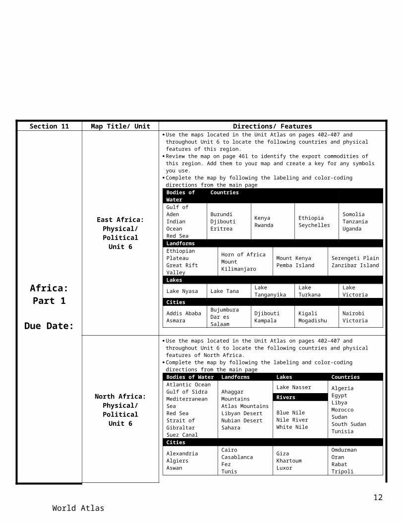
Section 11 Map Title/ Unit Directions/ Features
Africa:Part 1
Due Date:
East Africa: Physical/ PoliticalUnit 6
Use the maps located in the Unit Atlas on pages 402–407 and throughout Unit 6 to locate the following countries and physical features of this region.
Review the map on page 461 to identify the export commodities of this region. Add them to your map and create a key for any symbols you use.
Complete the map by following the labeling and color-coding directions from the main pageBodies of Water CountriesGulf of AdenIndian Ocean Red Sea
BurundiDjiboutiEritrea
KenyaRwanda
Ethiopia Seychelles
SomoliaTanzaniaUganda
LandformsEthiopian PlateauGreat Rift Valley
Horn of AfricaMount Kilimanjaro
Mount KenyaPemba Island
Serengeti PlainZanzibar Island
LakesLake Nyasa Lake Tana Lake Tanganyika Lake Turkana Lake VictoriaCitiesAddis AbabaAsmara
BujumburaDar es Salaam
DjiboutiKampala
KigaliMogadishu
NairobiVictoria
f
North Africa: Physical/ PoliticalUnit 6
Use the maps located in the Unit Atlas on pages 402–407 and throughout Unit 6 to locate the following countries and physical features of North Africa.
Complete the map by following the labeling and color-coding directions from the main pageBodies of Water Landforms Lakes Countries
Atlantic OceanGulf of SidraMediterranean SeaRed SeaStrait of GibraltarSuez Canal
Ahaggar MountainsAtlas MountainsLibyan DesertNubian DesertSahara
Lake Nasser AlgeriaEgyptLibyaMoroccoSudanSouth SudanTunisia
Rivers
Blue NileNile RiverWhite Nile
Cities
AlexandriaAlgiersAswan
CairoCasablancaFezTunis
GizaKhartoumLuxor
OmdurmanOranRabatTripoli
f
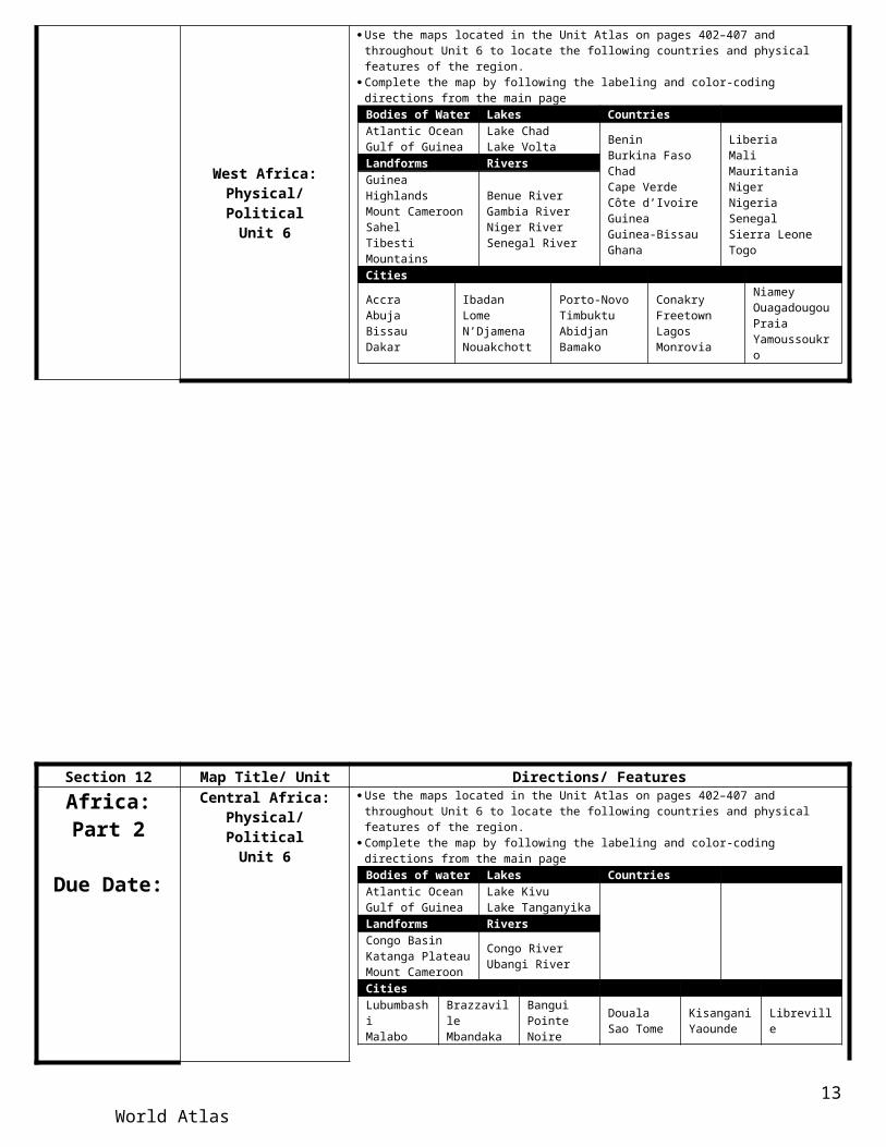
West Africa: Physical/ PoliticalUnit 6
Use the maps located in the Unit Atlas on pages 402–407 and throughout Unit 6 to locate the following countries and physical features of the region.
Complete the map by following the labeling and color-coding directions from the main pageBodies of Water Lakes CountriesAtlantic OceanGulf of Guinea
Lake ChadLake Volta
BeninBurkina FasoChadCape VerdeCôte d’IvoireGuineaGuinea-BissauGhana
LiberiaMaliMauritaniaNigerNigeriaSenegalSierra LeoneTogo
Landforms Rivers
Guinea HighlandsMount CameroonSahelTibesti Mountains
Benue RiverGambia RiverNiger RiverSenegal River
CitiesAccraAbuja BissauDakar
IbadanLomeN’DjamenaNouakchott
Porto-NovoTimbuktuAbidjanBamako
ConakryFreetownLagosMonrovia
NiameyOuagadougouPraiaYamoussoukro
f
World Atlas 9

Section 12 Map Title/ Unit Directions/ Features
Africa:Part 2
Due Date:
Central Africa: Physical/ Political
Unit 6
Use the maps located in the Unit Atlas on pages 402–407 and throughout Unit 6 to locate the following countries and physical features of the region.
Complete the map by following the labeling and color-coding directions from the main pageBodies of water Lakes CountriesAtlantic OceanGulf of Guinea
Lake KivuLake Tanganyika
Central African RepublicDemocratic Republic of the CongoSao Tome Principe
Republic of the CongoEquatorial GuineaGabon Cameroon
Landforms RiversCongo BasinKatanga PlateauMount Cameroon
Congo RiverUbangi River
CitiesLubumbashiMalabo
BrazzavilleMbandaka
BanguiPointe Noire
DoualaSao Tome
KisanganiYaounde Libreville
f
Southern Africa: Physical/ Political
Unit 6
Use the maps located in the Unit Atlas on pages 402–407 and throughout Unit 6 to locate the following countries and physical features of the region.
Review the map on page 407 of your textbook and identify the language groups of Southern Africa. Add them to your map and create a key for any symbols you use.
Complete the map by following the labeling and color-coding directions from the main pageBodies of Water Rivers Lake CountriesAtlantic OceanIndian OceanMozambique Channel
Limpopo RiverOrange RiverZambezi River
Lake Nyasa MalawiMozambiqueNamibiaSouth AfricaSwazilandZambiaZimbabwe Madagascar
Landforms Countries
Cape of Good HopeDrakensberg EscarpmentKarroo
Kalahari DesertNamib DesertReunionSaint HelenaVictoria Falls
AngolaBotswanaComorosLesothoMauritius
f
World Atlas 10

Section 13 Map Title/ Unit Directions/ Features
Southwest Asia
(Middle East)
Due Date:
Arabian Peninsula: Physical/ Political
Unit 7
Use the maps located in the Unit Atlas on pages 478–483 and throughout Unit 7 to locate the following countries and physical features of this region.
Complete the map by following the labeling and color-coding directions from the main pageBodies of Water Landforms Countries CitiesArabian SeaGulf of AdenGulf of AqabaGulf of OmanIndian OceanRed SeaPersian GulfStrait of Hormuz
An-NafudArabian PeninsulaHejazRub-al-KhaliNajdSyrian Desert
BahrainKuwaitOmanSaudi ArabiaQatarUnited Arab EmiratesYemen
Abu DhabiAdenDohaJiddahKuwait City ManamaMecca Medina
MuscatRiyadhSanaaIslandsSocotra
f
Eastern Mediterranean: Physical/ Political
Unit 7
Use the maps located in the Unit Atlas on pages 478–483 and throughout Unit 7 to locate the following countries and physical features of this region.
Complete the map by following the labeling and color-coding directions from the main pageBodies of Water Lakes and Rivers Landforms
Gulf of AqabaGulf of SuezMediterranean Sea
Dead SeaEuphrates RiverJordan RiverSea of Galilee
NegevGolan HeightsGaza Strip
Mount HermonSinai Peninsula (Egypt)Syrian Desert
Territories Countries Cities
PalestineGaza StripGolan HeightsWest Bank
CyprusIsraelJordanLebanonSyria
AleppoAmmanBeirutDamascus
HaifaJerusalemNicosiaTel Aviv-Yafo
f
The Northeast: Physical/ PoliticalUnit 7
Use the maps located in the Unit Atlas on pages 478–483 and throughout Unit 7 to locate the following countries and physical features of this region.
Review the map on page 516 and add the ethnic groups of this region using symbols. Create a map key with this information.
Complete the map by following the labeling and color-coding directions from the main pageBodies of Water Landforms
Aegean SeaBlack SeaBosphorusCaspian SeaDaranellasGulf of Oman
Indian OceanMedieterranean SePersian GulfRed SeaSea of MarmaraStrait of Hormuz
AnatoliaDasht-e KavirDasht-e LutElburz MountainsHindu KushPlateau of Iran
Pontic MountainsTaurus MountainsZagros MountainsRiversDiyalaEuphratesTigris
Countries CitiesAfghanistanIranIraqTurkey
AnkaraBaghdadBasraEsfahan
IstanbullIzmirKabulMashhad
MosulQomTehran
f
World Atlas 11
Section 14 Map Title/ Unit Directions/ Features
South Asia:Part 1
Due Date:
India:Physical/ Political
Unit 8
Use the maps located in the Unit Atlas on pages 542–547 and throughout Unit 8 to locate the following countries, political units, and physical features of this region.
Complete the map by following the labeling and color-coding directions from the main pageBodies of Water Rivers Landforms MountainsAndaman SeaArabian SeaBay of BengalGulf of KhambhatGulf of MannarIndian OceanLaccadive Sea
BrahmaputraGangesGodavariIndusKrishnaNarmada
Chota Nagpur PlateauDeccan PlateauGanges DeltaIndo-Gangetic PlainRann of KutchThar Desert
Eastern GhatsHimalayan MountainsKarakoram RangeVindhya RangeWestern Ghats
Cities CountryAhmadabadBangaloreChennai (Madras)Delhi
KanpurKokata (Calcutta)HyderabadLucknow
Mumbai (Bombay)NagputNew Delhi
IndiaTerritoryKashmir
F
Pakistan and Bangladesh: Physical/
PoliticalUnit 8
Use the maps located in the Unit Atlas on pages 542–547 and throughout Unit 8 to locate the following countries, political units, and physical features of this region.
Complete the map by following the labeling and color-coding directions from the main pageBodies of Water Countries Landforms CitiesArabian SeaBay of Bengal
BangladeshIndia Ganges delta
Hindu Kush MountainsK2Karakoram RangeKhyber PassSulaiman Range
ChittagongDhakaFaisalabadHyderabadIslamabadKarachiLahoreRawalpindi
Rivers Region
BrahmaputraGangesIndus
BaluchistanKashmirMakranPunjab
f
Section 15 Map Title/ Unit Directions/ Features
South Asia:Part 2
Due Date:
Nepal and Bhutan: Physical/ Political
Unit 8
Use the maps located in the Unit Atlas on pages 542–547 and throughout Unit 8 to locate the following countries, political units, and physical features of this region.
Complete the map by following the labeling and color-coding directions from the main pageRiver Mountains Countries CitiesBrahmaputraGanges
Himalaya MountainsMount Everest
Bhutan Nepal
KathmanduThimphu
f
Indian Ocean: Physical/ PoliticalUnit 8
Use the maps located in the Unit Atlas on pages 542–547 and throughout Unit 8 to locate the following countries, political units, and physical features of this region.
Complete the map by following the labeling and color-coding directions from the main pageBodies of Water Countries Cities
Arabian SeaBay of BengalGulf of MannarIndian OceanLaccadive SeaPalk Strait
CambodiaEthiopiaIndonesiaMadagascarMaldivesMyanmar
Saudi ArabiaSingaporeSri LankaYemenComorosIndia
KenyaMalaysiaMauritiusOmanSeychellesSomaliaThailand
ColomboBangkokKolkata (Calcutta)MaleMumbai (Bombay
f
World Atlas 12
Section 16 Map Title/ Unit Directions/ Features
East Asia:Part 1
Due Date:
China: Physical/ PoliticalUnit 9
Use the maps located in the Unit Atlas on pages on pages 610–615 and throughout Unit 9 to locate the following country, other political units, and physical features.
Complete the map by following the labeling and color-coding directions from the main pageRivers CitiesAmurBrahmaputraChang Jiang (Yangtze)Huang He (Yellow)Liao HeSonghua
Tarim HeWei HeYalu JiangXi Jiang (West)Zhu Jiang (Pearl)
Beijing ChongqingGuangzhouHarbinNanjing
ShanghaiShenyangTianjinWuhanXi’an
Oceans and Seas Major LandformsBo HaiEast China SeaGuld of TonkinSea of Japan
South China SeaTaiwan StraitYellow Sea
GobiHainan IslandJunggar BasinManchurain Plain
North China PlainPlateau of TibetTaklimakan Desert
Mountains Features
Altun MountainsGreat Khingan MountainsHimalay Mountains
Karakoram RangeKunlun MountainsQinling ShandiTian Shan
Grand CanalGreat WallThree Georges Dam
ff
Mongolia and Taiwan: Physical/ Political
Unit 9
Use the maps located in the Unit Atlas on pages on pages 610–615 and throughout Unit 9 to locate the following country, other political units, and physical features.
Create a legend to identify any colors or symbols used Complete the map by following the labeling and color-coding directions from the main page
Bodies of Water Landforms Cities
East China SeaLake BaikalLuzon Strait
Pacific OceanSouth China SeaTaiwan Strait
Altai MountainsGobi DesertMongolian Plateau
TaipeiUlaanbaatorCountriesMongolia Taiwain
f
Section 17 Map Title/ Unit Directions/ Features
East Asia:Part 2
Due Date:
The Koreas: Physical/ PoliticalUnit 9
Use the maps located in the Unit Atlas on pages 610–615 and throughout Unit 9 to locate the following countries, political units, and physical features of this region.
Create a legend for any colors or symbols used. Complete the map by following the labeling and color-coding directions from the main page
Bodies of Water Countries Rivers CitiesKorea BayKorea StraitSea of JapanYellow Sea
North KoreaSouth Korea
Yalu JiangPusanPyongyangSeoul
CitiesLandforms Inchon
PanmunjomCheju IslandNatural ResourcesCommercial fishing Silver Tungsten
f
Japan: Physical/ PoliticalUnit 9
Use the maps located in the Unit Atlas on pages 610–615 and throughout Unit 9 to locate the following country, political units, and physical features of this region.
Create a legend for any colors or symbols used. Complete the map by following the labeling and color-coding directions from the main page
Bodies of Water IslandsEast China SeaKorea Strait
Pacific OceanSea of Japan
HokkaidoHonshu
KyushuRyukyu Shikoku
Landforms Country Cities
Mount Fuji Japan FukuokaHiroshima
KyotoNagoya
OsakaSapporo
TokyoYokohama
Vegetation Natural ResourcesConiferous forestDeciduous and mixed forestTropical rain forest
CoalCommercial fishingGold
Hydroelectric powerLeadtungsten
f
World Atlas 13

Section 18 Map Title/ Unit Directions/ Features
Southeast Asia, Oceania,
and Antarctica:
Due Date:
Southeast Asia: Physical/ Political
Unit 10
Use the maps located in the Unit Atlas on pages 678–683 and throughout Unit 10 to locate the following countries, political units, and physical features of this region.
Complete the map by following the labeling and color-coding directions from the main pageBodies of Water Rivers Countries
Andaman SeaBanda SeaFlores SeaPhilippine SeaSulu SeaTimor Sea
Arafura SeaCelebes SeaGulf of ThailandIndian OceanPacific OceanSouth China SeaStrait of Malacca
IrrawaddyMekongRedSalween
BruneiCambodiaEast Timor (UN)IndonesiaLaosMalayasia
MyanmarPhilippinesSingaporeThailandVietnam
LandformsIndochinaMalay Peninsula
CitiesBander Seri BegawanBangokokHanoiJakartaLuzon
MedanPhnom PenhSemarangSurabavaYangon
BandungDavaoHo Chi Minh CityKuala LumpurManila
PalembangQuezon CitySingapore CityVientiane
f
Oceania: Physical/ PoliticalUnit 10
Use the maps located in the Unit Atlas on pages 678–683 and throughout Unit 10 to locate the following countries, political units, and physical features of this region.
Circle the boundaries of the sub regions of Micronesia, Melanesiam, and Polynesia with colored pens (other than blue or black). Make a map key to identify them.
Complete the map by following the labeling and color-coding directions from the main pageBodies of Water IslandsCoral SeaPacific OceanTasman SeaTorres Strait
Caroline IslandsGilbert IslandsLine IslandsMariana Islands
New BritainNew GuineaNew IrelandPhoenix Islands
Santa Cruz IslandsSociety Islands Tuamotu Archipelago
TerritoriesAmerica Samoa (US)Cook Islands (NZ)French Polynesia (Fr)Guam (US)Irian Jaya (Indo)
NiiueNorthern Mariana Island (US)Papua New GuineaPitcairn Islands (Br)
New Caledonia (Fr)Tahiti TasmaniaTokelau (NZ)
Wallis and Futuna (Fr)Sub regionsMelanesiaMicronesiaPolynesia
Countries CitiesFederated States of MicronesiaFijiKiribatiMarshal IslandsNauruPalau
Papua New GuineaSamoaSolomon IslandsTongaTuvaluVanuatu
ApiaBairikiFongafaleHoniaraKororMajuroTarawa
NoumeaNuku’alofaPapeetePalikirPort MoresbyPort-vilaSuva
f
Australia, New Zealand, Antarctica: Physical/
PoliticalUnit 10
Use the maps located in the Unit Atlas on pages 678–683 and throughout Unit 10 to locate the following countries, political units, and physical features of this region.
Include the states and territories of Australia and sub regions of Antarctica. Label them on the map. Then add the International Dateline. Complete the map by following the labeling and color-coding directions from the main page
Bodies of WaterDrake Passage Great Australian BightGulf of Carpentaria
Arufura SeaAtlantic OceanCoral Sea
Indian OceanPacific OceanTorres strait
Scotia SeaTasman SeaTimor Sea
Ross SeaWeddell Sea
Rivers Continents Islands CountriesDarling RiverMurray River
AntarcticaAustralia
North and South Is.Tasmania
AustraliaNew Zealand
Landforms Regions Cities
Antarctic PeninsulaEast AntarcticaGreat Artesian BasinGreat Barrier ReefGreat Dividing RangeTransantarctic Mts.Vinson Massif
Great Sandy DesertGreat Victoria DesertKimberly PlateauMount KosciuskoRonne Ice ShelfRoss Ice ShelfSouth PoleWest Antarctica
Enderby LandMaria Byrd LandPalmer LandQueen Maud LandVictoria LandWilkes Land
AucklandBrisbaneDarwinPerthSidney
AdelaideCanberraChristchurchMelbourneWellington
f
World Atlas 14

Map RubricObjective Below Basic
1 pointBasic
2 pointsProficient3 points
Exemplary4 points
Earned Points
Section Title Page
Section title page has no graphics
Title page has unsuitable graphics
Title page has graphics but lacks
creativity or neatness
Title page shows creativity and is colorful. Pride in work is evident.
Title of Map Map has no title
Title is in wrong place, or does not adhere to all of the
guidelines.
Title is appropriately placed, in large,
dark, bold letters, in black ink but is not big enough to be
easily distinguished
Title is appropriately placed, in large,
dark, bold letters, in black ink, and is
easy to read.
Labeling
50% or more of the map (s) is
incorrectly or not labeled
25% of the map(s) is incorrectly or not
labeled
Map(s) is correctly labeled but does not
adhere to proper labeling guidelines.
Map(s) is correctly labeled and follows
all labeling guidelines. Pride in
work is evident
Coloring50% of the map(s) is not colored correctly and lacks outlining
25% of the map(s) is colored incorrectly or lacks outlining
Map(s) is colored appropriately but does not adhere to
proper coloring guidelines.
Map(s) is colored and outlined
appropriately and follows all coloring guidelines. Pride in
work is evident
Neatness
Map(s) seems hastily done or is torn, smudged, or
wrinkled
While clean and unwrinkled, map
seems hastily done.Map(s) is neat.
Map(s) is neat, clean and not smudged. Pride in work is
evident.
Note: A missing title page, or missing labeling or coloring earns a ZERO, not a 1.
Total Points
Final Score
World Atlas 15