Embed Size (px)
Citation preview
World Heritage 38 COM WHC-14/38.COM/8B
Paris, 30 April 2014 Original: English / French
UNITED NATIONS EDUCATIONAL, SCIENTIFIC AND CULTURAL ORGANIZATION
CONVENTION CONCERNING THE PROTECTION OF THE WORLD CULTURAL AND NATURAL HERITAGE
WORLD HERITAGE COMMITTEE
Thirty-eighth session
Doha, Qatar 15 – 25 June 2014
Item 8 of the Provisional Agenda: Establishment of the World Heritage List and of the List of World Heritage in Danger 8B. Nominations to the World Heritage List
SUMMARY This document presents the nominations to be examined by the Committee at its 38th session (Doha, 2014). It is divided into four sections:
I Changes to names of properties inscribed on the World Heritage List II Examination of nominations of natural, mixed and cultural properties to the World Heritage List III Statements of Outstanding Universal Value of the three properties inscribed at the 37th session (Phnom
Penh, 2013) and not adopted by the World Heritage Committee IV Record of the physical attributes of each property being discussed at the 38th session
The document presents for each nomination the proposed Draft Decision based on the recommendations of the appropriate Advisory Body(ies) as included in WHC-14/38.COM/INF.8B1 and WHC-14/38.COM/INF.8B2 and it provides a record of the physical attributes of each property being discussed at the 38th session. The information is presented in two parts:
• a table of the total surface area of each property and any buffer zone proposed, together with the geographic coordinates of each site's approximate centre point; and
• a set of separate tables presenting the component parts of each of the 16 proposed serial properties. Decisions required: The Committee is requested to examine the recommendations and Draft Decisions presented in this Document, and, in accordance with paragraph 153 of the Operational Guidelines, take its Decisions concerning inscription on the World Heritage List in the following four categories: (a) properties which it inscribes on the World Heritage List; (b) properties which it decides not to inscribe on the World Heritage List; (c) properties whose consideration is referred; (d) properties whose consideration is deferred.
Nominations to the World Heritage List WHC-14/38.COM/8B, p. 1
I. CHANGES TO NAMES OF PROPERTIES INSCRIBED ON THE WORLD HERITAGE LIST
1. At the request of the Maltese authorities, the Committee is asked to approve a change to the English and French names of Hal Saflieni Hypogeum, inscribed on the World Heritage List in 1980, in order to use the Maltese characters.
Draft Decision: 38 COM 8B.1
The World Heritage Committee,
1. Having examined Document WHC-14/38.COM/8B,
2. Approves the name change to Hal Saflieni Hypogeum as proposed by the Maltese authorities. The name of the property becomes Ħal Saflieni Hypogeum in English and Ipogée de Ħal Saflieni in French.
2. At the request of the Swedish authorities, the Committee is asked to approve a change to the English and French names of the Church Village of Gammelstad, Luleå, inscribed on the World Heritage List in 1996.
Draft Decision: 38 COM 8B.2
The World Heritage Committee,
1. Having examined Document WHC-14/38.COM/8B,
2. Approves the name change to the Church Village of Gammelstad, Luleå as proposed by the Swedish authorities. The name of the property becomes Church Town of Gammelstad, Luleå in English and Ville-église de Gammelstad, Luleå in French.
3. At the request of the Swedish authorities, the Committee is asked to approve a change to the English and French names of the Varberg Radio Station, inscribed on the World Heritage List in 2004.
Draft Decision: 38 COM 8B.3
The World Heritage Committee,
1. Having examined Document WHC-14/38.COM/8B,
2. Approves the name change to Varberg Radio Station as proposed by the Swedish authorities. The name of the property becomes Grimeton
Radio Station, Varberg in English and Station radio Grimeton, Varberg in French.
Nominations to the World Heritage List WHC-14/38.COM/8B, p. 2
II. EXAMINATION OF NOMINATIONS OF NATURAL, MIXED AND CULTURAL PROPERTIES TO THE WORLD HERITAGE LIST
Summary
At its 38th session, the Committee will be examining a total of 41 nominations including one nomination to be processed on an emergency basis.
Out of the total of 41 nominations, 32 are new nominations, having not been presented previously, 5 are extensions of boundaries and 4 nominations were deferred or referred by previous sessions of the Committee.
Of these nominations, ICOMOS and IUCN are recommending 12* nominations for inscription on the World Heritage List and are recommending 3 extensions for approval.
* Please note that the draft decisions of 3 nominations referred back by previous sessions of the World Heritage Committee as well as the draft decision of one nomination to be processed on an emergency basis are not included in this document [See Addendum: WHC-14/38.COM/8B.Add].
Nominations withdrawn at the request of the State Party
At the time of preparation of this document, no nomination has been withdrawn.
Presentation of Nominations
Within the natural, mixed and cultural groups, nominations are being presented by IUCN and ICOMOS in English alphabetical and regional order: Africa, Arab States, Asia and the Pacific, Europe and North America, Latin America and the Caribbean. The printed Advisory Bodies’ evaluation documents and this working document are presented in this order. As in the past, for ease of reference, an alphabetical summary table and index of recommendations is presented at the beginning of this document (p. 3-4).
Nominations to the World Heritage List WHC-14/38.COM/8B, p. 3
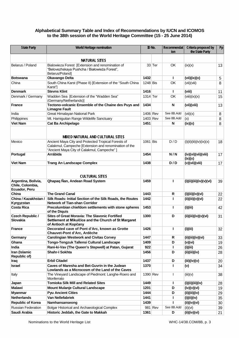
Alphabetical Summary Table and Index of Recommendations by IUCN and ICOMOS to the 38th session of the World Heritage Committee (15 - 25 June 2014)
State Party World Heritage nomination ID No. Recommendation
Criteria proposed by the State Party
Pp
NATURAL SITES
Belarus / Poland Bialowieza Forest [Extension and renomination of “Belovezhskaya Pushcha / Białowieża Forest”, Belarus/Poland]
33 Ter OK (ix)(x) 13
Botswana Okavango Delta 1432 I (vii)(ix)(x) 5 China South China Karst (Phase II) [Extension of the “South China
Karst”] 1248 Bis OK (vii)(viii) 8
Denmark Stevns Klint 1416 I (viii) 11 Denmark / Germany Wadden Sea [Extension of the “Wadden Sea”
(Germany/Netherlands)] 1314 Ter OK (viii)(ix)(x) 15
France Tectono-volcanic Ensemble of the Chaine des Puys and Limagne Fault
1434 N (vii)(viii) 13
India Great Himalayan National Park 1406 Rev See 8B.Add (vii)(x) 8 Philippines Mt. Hamiguitan Range Wildelife Sanctuary 1403 Rev See 8B.Add (x) 8 Viet Nam Cat Ba Archipelago 1451 N (ix)(x) 8
MIXED NATURAL AND CULTURAL SITES
Mexico Ancient Maya City and Protected Tropical Forests of Calakmul, Campeche [Extension and renomination of the “Ancient Maya City of Calakmul, Campeche” ]
1061 Bis D / D (i)(ii)(iii)(iv)(ix)(x) 18
Portugal Arrábida 1454 N / N (iv)(vi)(vii)(viii) (ix)(x)
17
Viet Nam Trang An Landscape Complex 1438 D / D (v)(vii)(viii) 17
CULTURAL SITES
Argentina, Bolivia, Chile, Colombia, Ecuador, Peru
Qhapaq Ñan, Andean Road System 1459 I (i)(ii)(iii)(iv)(v)(vi) 39
China The Grand Canal 1443 R (i)(iii)(iv)(vi) 22 China / Kazakhstan / Kyrgyzstan
Silk Roads: Initial Section of the Silk Roads, the Routes Network of Tian-shan Corridor
1442 I (ii)(iii)(v)(vi) 22
Costa Rica Precolumbian chiefdom settlements with stone spheres of the Diquís
1453 I (i)(iii) 42
Czech Republic / Slovakia
Sites of Great Moravia: The Slavonic Fortified Settlement at Mikulčice and the Church of St Margaret of Antioch at Kopčany
1300 D (ii)(iii)(iv)(v)(vi) 31
France Decorated cave of Pont d’Arc, known as Grotte Chauvet-Pont d’Arc, Ardèche
1426 I (i)(iii) 32
Germany Carolingian Westwork and Civitas Corvey 1447 R (ii)(iii)(iv)(vi) 33 Ghana Tongo-Tengzuk Tallensi Cultural Landscape 1409 D (v)(vi) 19 India Rani-ki-Vav (The Queen’s Stepwell) at Patan, Gujarat 922 I (i)(iii) 26 Iran (Islamic Republic of)
Shahr-I Sokhta 1456 D (ii)(iii)(iv) 28
Iraq Erbil Citadel 1437 D (iii)(iv)(v) 20 Israel Caves of Maresha and Bet-Guvrin in the Judean
Lowlands as a Microcosm of the Land of the Caves 1370 I (v) 34
Italy The Vineyard Landscape of Piedmont: Langhe-Roero and Monferrato
1390 Rev I (iii)(v) 38
Japan Tomioka Silk Mill and Related Sites 1449 I (i)(ii)(iii)(iv) 28 Malawi Mount Mulanje Cultural Landscape 1201 D (iv)(v)(vi) 19 Myanmar Pyu Ancient Cities 1444 D (ii)(iii)(iv) 29 Netherlands Van Nellefabriek 1441 I (i)(ii)(iv) 35 Republic of Korea Namhansanseong 1439 I (ii)(iv)(vi) 30 Russian Federation Bolgar Historical and Archaeological Complex 981 Rev See 8B.Add (ii)(vi) 39 Saudi Arabia Historic Jeddah, the Gate to Makkah 1361 D (ii)(iv)(vi) 21
Nominations to the World Heritage List WHC-14/38.COM/8B, p. 4
State Party World Heritage nomination ID No. Recommendation
Criteria proposed by the State Party
Pp
Spain Cultural Landscape of Valle Salado de Añana 1445 N (iii)(iv)(v) 36
Spain Jaén Cathedral [Extension of the “Renaissance Monumental Ensemble of Ubeda and Baeza”]
522 Bis NA (ii)(iv) 38
Tajikistan / Uzbekistan
Silk Roads: Penjikent-Samarkand-Poykent Corridor 1460 D (ii)(iii)(iv)(v)(vi) 31
Turkey Bursa and Cumalıkızık: the Birth of the Ottoman Empire 1452 D (i)(ii)(iii)(iv)(vi) 36 Turkey Pergamon and its Multi-Layered Cultural Landscape 1457 D (i)(ii)(iii)(iv)(vi) 37 United Arab Emirates
Khor Dubai (Dubai Creek) 1458 N (ii)(v) 21
United States of America
Monumental Earthworks of Poverty Point 1435 D (iii) 37
Zambia Barotse Cultural Landscape 1429 D (iii)(iv)(vi) 20 NOMINATIONS TO BE PROCESSED ON AN EMERGENCY BASIS
Date of receipt 30/01/2014 Palestine Palestine: Land of Olives and Vines – Cultural
Landscape of Southern Jerusalem, Battir 1492 See 8B.Add (iv)(v) 5
KEY
I Recommended for inscription R Recommended for referral D Recommended for deferral OK Approval Recommended of an extension or a modification N Not recommended for inscription NA Not approved extension (i) (ii) etc Cultural and/or Natural criteria proposed by the State Party Nominations highlighted in bold are considered "new", having not been presented to the Committee previously.
Nominations to the World Heritage List WHC-14/38.COM/8B, p. 5
In the presentation below, IUCN Recommendations and ICOMOS Recommendations are both presented in the form of Draft Decisions and are abstracted from WHC-14/38.COM/INF.8B1 (ICOMOS) and WHC-14/38.COM/INF.8B2 (IUCN).
Though Draft Decisions were taken from IUCN and ICOMOS evaluations books, in some cases, a few modifications were required to adapt them to this Document.
A. NOMINATIONS TO BE PROCESSED ON AN EMERGENCY BASIS
Property Palestine: Land of Olives and Vines – Cultural Landscape of Southern Jerusalem, Battir
Id. N° 1492 State Party Palestine Criteria proposed by State Party
(iv)(v)
See document WHC-14/38.COM/INF.8B2.Add
Draft Decision: 38 COM 8B.4
[See Addendum: WHC-14/38.COM/8B.Add]
B. NATURAL SITES
B.1. AFRICA
B.1.1. New Nominations
Property Okavango Delta Id. N° 1432 State Party Botswana Criteria proposed by State Party
(vii)(ix)(x)
See IUCN Evaluation Book, May 2014, page 3.
Draft Decision: 38 COM 8B.5
The World Heritage Committee,
1. Having examined Documents WHC-14/38.COM/8B and WHC-14/38.COM/INF.8B2,
2. Inscribes Okavango Delta, Botswana, on the World Heritage List on the basis of criteria (vii), (ix) and (x);
3. Adopts the following Statement of Outstanding Universal Value:
Brief Synthesis The Okavango Delta is a large low gradient alluvial fan or ‘Inland Delta’ located in north-western Botswana. The area includes permanent swamps which cover approximately 600,000 ha along with up to 1.2m ha of seasonally flooded grassland. The inscribed World Heritage property
encompasses an area of 2,023,590 ha with a buffer zone of 2,286,630 ha. The Okavango Delta is one of a very few large inland delta systems without an outlet to the sea, known as an endorheic delta, its waters drain instead into the desert sands of the Kalahari Basin. It is Africa’s third largest alluvial fan and the continent’s largest endorheic delta. Furthermore it is in a near pristine state being a largely untransformed wetland system. The biota has uniquely adapted their growth and reproductive behaviour, particularly the flooded grassland biota, to be timed with the arrival of floodwater in the dry, winter season of Botswana. The geology of the area, a part of the African Rift Valley System, has resulted in the ‘capture’ of the Okavango River that has formed the Delta and its extensive waterways, swamps, flooded grasslands and floodplains. The Okavango River, at 1,500kms, is the third largest in southern Africa. The Delta’s dynamic geomorphological history has a major effect on the hydrology, determining water flow direction, inundation and dehydration of large areas within the Delta system. The site is an outstanding example of the interplay between climatic, geomorphological, hydrological, and biological processes that drive and shape the system and of the manner in which the Okavango Delta’s plants and animals have adapted their lifecycles to the annual cycle of rains and flooding. Subsurface precipitation of calcite and amorphous silica is an important process in creating islands and habitat gradients that support diverse terrestrial and aquatic biota within a wide range of ecological niches. Criterion (vii): Permanent crystal clear waters and dissolved nutrients transform the otherwise dry Kalahari Desert habitat into a scenic landscape of exceptional and rare beauty, and sustain an ecosystem of remarkable habitat and species diversity, thereby maintaining its ecological resilience and amazing natural phenomena. The annual flood-tide, which pulses through the wetland system every year, revitalizes ecosystems and is a critical life-force during the peak of the Botswana’s dry season (June/July). The Okavango Delta World Heritage property displays an extraordinary juxtaposition of a vibrant wetland in an arid landscape and the miraculous transformation of huge sandy, dry and brown depressions by winter season floods triggers spectacular wildlife displays: large herds of African Elephant, Buffalo, Red Lechwe, Zebra and other large animals splashing, playing, and drinking the clear waters of the Okavango having survived the dry autumn season or their weeks’ long migration across the Kalahari Desert. Criterion (ix): The Okavango Delta World Heritage property is an outstanding example of the complexity, inter-dependence and interplay of climatic, geo-morphological, hydrological, and biological processes. The continuous transformation of geomorphic features such as islands, channels, river banks, flood plains, oxbow
Nominations to the World Heritage List WHC-14/38.COM/8B, p. 6
lakes and lagoons in turn influences the abiotic and biotic dynamics of the Delta including dryland grasslands and woodland habitats. The property exemplifies a number of ecological processes related to flood inundation, channelization, nutrient cycling and the associated biological processes of breeding, growth, migration, colonization and plant succession. These ecological processes provide a scientific benchmark to compare similar and human-impacted systems elsewhere and give insight into the long-term evolution of such wetland systems. Criterion (x): The Okavango Delta World Heritage property sustains robust populations of some of the world’s most endangered large mammals such as Cheetah, white and black Rhinoceros, Wild Dog and Lion, all adapted to living in this wetland system. The Delta’s habitats are species rich with 1061 plants (belonging to 134 families and 530 genera), 89 fish, 64 reptiles, 482 species of birds and 130 species of mammals. The natural habitats of the nominated area are diverse and include permanent and seasonal rivers and lagoons, permanent swamps, seasonal and occasionally flooded grasslands, riparian forest, dry deciduous woodlands, and island communities. Each of these habitats has a distinct species composition comprising all the major classes of aquatic organisms, reptiles, birds and mammals. The Okavango Delta is further recognized as an Important Bird Area, harbouring 24 species of globally threatened birds, including among others, six species of Vulture, the Southern Ground-Hornbill, Wattled Crane and Slaty Egret. Thirty-three species of water birds occur in the Okavango Delta in numbers that exceed 0.5% of their global or regional population. Finally Botswana supports the world’s largest population of elephants, numbering around 130,000: the Okavango Delta is the core area for this species’ survival. Integrity The property covers most of the Delta, encompassing a vast area of over 2 millions ha of substantially undisturbed wetlands and seasonally flooded grasslands. It is of sufficient size to represent all of the delta’s main biophysical processes and features and support its communities of plant and animal species. Because of its vast size and difficult access the delta has never been subject to significant development and it remains in an almost pristine condition. Tourism to the inner Delta is limited to small, temporary tented camps with access by air. Facilities are carefully monitored for compliance with environmental standards and have minimal ecological impact. Most importantly, the source of the Okavango Delta’s waters in Angola and Namibia remain unaffected by any upstream dams or significant water abstraction and the three riparian states have established a protocol under the Permanent Okavango River Basin Water Commission (OKACOM) for the sustainable management of the entire river system. OKACOM has formally supported the
inscription of the Okavango Delta on the World Heritage List. It is imperative that upstream environmental water flows remain unimpeded and that over abstraction of water, the building of dams and the development of agricultural irrigation systems do not impact on the sensitive hydrology of the property. Concerns have been noted regarding fluctuating populations of large animals. Elephant numbers have been increasing whilst other species are reported as exhibiting significant declines. Data is variable, subject to different survey techniques and uncoordinated surveys undertaken by different institutions all contribute to an unclear picture of the Okavango Delta’s wildlife. Authorities have initiated efforts to establish a comprehensive and integrated wildlife monitoring system that can accurately track population size and trends for the entire property, however ongoing work is needed to realise this. Causes of decline are attributed to seasonal variability, poaching (for example of giraffe for meat) and veterinary cordon fencing used to manage animal sanitation and control the spread of disease between wildlife and domestic stock. Mining activities including prospecting will not be permitted within the property. Furthermore, potential impacts from mining including concessions in the buffer zone and outside the buffer zone need to be carefully monitored and managed to avoid direct and indirect impacts to the property, including water pollution. The State Party should also work with State Parties upstream from the Delta to monitor any potential impacts, including from potential diamond mining in Angola, which could impact water flow or water quality in the Delta. Protection and management requirements The Okavango Delta comprises a mosaic of protected lands. About 40% of the property is protected within the Moremi Game Reserve, and the remainder is composed of 18 Wildlife Management Areas and a Controlled Hunting Areas managed by community trusts or private tourism concession-holders. Legal protection is afforded through Botswana’s Wildlife Conservation and National Parks Act, 1992 and an associated Wildlife Conservation Policy. The Tribal Land Act of 1968 also applies to the property and the whole of the nominated area (and the buffer zone) is communally-owned Tribal Land under the control of the Tawana Land Board. As noted above the underlying causes of wildlife population declines are not clear, but an imposed hunting ban will further strengthen conservation measures in the property. The State Party is encouraged to develop a coordinated and systematic wildlife monitoring programme to establish population baselines for key species and to track trends. Veterinary cordon fences are known to cause significant disruption to wildlife at individual, population and species levels. Most of

Nominations to the World Heritage List WHC-14/38.COM/8B, p. 7
the property’s core and buffer zones are free of veterinary cordon fencing and the location of site’s boundaries was guided by these considerations. However, the Southern Buffalo Fence defines the southern boundary of the World Heritage property and whilst damage has compromised its effectiveness in disease control, it acts as a locally known demarcation to stop cattle grazing within the property. The Northern Buffalo Fence, also within the alignment of the property buffer zone, is known to disrupt connectivity in particular for the region’s Roan and Sable Antelope populations. Veterinary fencing is recognised as a sensitive, multi-dimensional issue. The State Party is encouraged to continue efforts to rationalize fencing, removing it when its effectiveness for disease control has become questionable or where more holistic approaches to animal sanitation and disease control are possible. Ongoing vigilance is critical to ensure mining developments do not adversely impact the property. Past mining prospecting licences have been extinguished, and will not be renewed or extended. No extractive activity is undertaken in the property, and no new licenses will be issued within the property. The State Party should implement rigorous environmental impact assessment procedures for mining activities outside the property but which have the potential to negatively impact on its Outstanding Universal Value, to avoid such impacts. The Delta has been inhabited for centuries by small numbers of indigenous people, living a hunter-gatherer existence with different groups adapting their cultural identity and lifestyle to the exploitation of particular resources (e.g. fishing or hunting). This form of low-level subsistence use has had no significant impact on the ecological integrity of the area, and today mixed settlements of indigenous peoples and later immigrants to the area are located around the fringes of the delta, mostly outside the boundaries of the property. Continued special attention is needed to reinforce the recognition of the cultural heritage of indigenous inhabitants of the Delta region. Ongoing efforts should focus upon sensitively accommodating traditional subsistence uses and access rights consistent with the protection of the property’s Outstanding Universal Value. Efforts should centre on ensuring that indigenous peoples living in the property are included in all communication about the World Heritage status of the property and its implications, that their views are respected and integrated into management planning and implementation, and that they have access to benefits stemming from tourism. The State Party is encouraged to address a range of other protection and management issues to improve integrity. These include enhanced governance mechanisms to empower stakeholders in the management of the property; the development of a property specific management plan which harmonizes with planning in the wider landscape; ensuring
adequate staffing and funding to build the capacity of the Department of Wildlife and National Parks; and programmes to strengthen the control and elimination of invasive alien species from the property.
4. Commends the efforts and achievements of the State Party and its neighbouring countries for adopting significant measures serving the long term conservation and protection of the property;
5. Requests the State Party to:
a) continue efforts to develop, in partnership with Universities, NGOs and wildlife experts, a coordinated and systematic wildlife monitoring programme to establish population baselines for key species and to track long term trends;
b) continue efforts to rationalize veterinary cordon fencing, removing it when its effectiveness for disease control has become questionable or where more holistic approaches to animal sanitation and disease control are possible;
c) ensure no extractive industry activity is permitted in the property, and permanently extinguish all the few remaining mineral prospecting concessions, which are scheduled to expire in 2014, without awarding any timeframe extensions and not issue any new concessions within the property;
d) carefully monitor and manage mining in areas outside of the property so as to avoid any adverse impacts to the property;
e) expand and strengthen programmes which accommodate traditional resource use for livelihoods, user access rights, cultural rights and access to opportunities to participate in the tourism sector, in keeping with the property’s Outstanding Universal Value; and
f) continue efforts to address a range of other protection and management issues including governance, stakeholder empowerment, management planning, management capacity and control of alien invasive species.
6. Further requests the State Party to submit, by 1 February 2016, a report, including a 1-page executive summary, on the state of conservation of the property, including confirmation of progress on the issues and actions noted above to ensure effective protection and management of the property, for examination by the World Heritage Committee at its 40th session in 2016.
Nominations to the World Heritage List WHC-14/38.COM/8B, p. 8
B.2. ASIA / PACIFIC
B.2.1. New Nominations
Property Cat Ba Archipelago Id. N° 1451 State Party Viet Nam Criteria proposed by State Party
(ix)(x)
See IUCN Evaluation Book, May 2014, page 31.
Draft Decision: 38 COM 8B.6
The World Heritage Committee,
1. Having examined Documents WHC-14/38.COM/8B and WHC-14/38.COM/INF.8B2,
2. Decides not to inscribe Cat Ba Archipelago, Viet Nam, on the World Heritage List;
3. Takes note that Cat Ba Archipelago is adjacent to the existing Ha Long Bay World Heritage Site and both are a part of the same archipelago sharing both inland and marine areas, and sharing a common marine boundary of more than 20kms;
4. Recommends the State Party to consider the possibility of proposing an extension of Ha Long Bay, under criteria (vii) and (viii) and possibly criterion (x), to include Cat Ba Archipelago, as this would add values and improved integrity to the existing inscribed property of Ha Long Bay and also recommends that the State Party evaluate the possibility of including other important karst areas in Viet Nam in a serial extension of Ha Long Bay;
5. Draws the attention of the State Party to the range of severe threats to the nominated property, and within the wider Ha Long Bay area, and further recommends the State Party to take action to address the following concerns prior to the submission of an extension:
a) poaching and hunting impacts on Cat Ba Langur to ensure fragile recovery efforts are not compromised;
b) tourism use pressure and associated boating impacts;
c) large scale tourism development with potential for serious reclamation, pollution and overuse impacts;
d) water and solid waste pollution impacts from major urban centres such as Cat Ba Town;
e) dredging spoil and industrial waste disposal impacts from the development of the new Hai Phong Port facility; and
f) pollution impacts from unregulated fish farm development.
6. Strongly encourages the State Party to strengthen and continue its efforts in conservation of the Critically Endangered Cat Ba Langur, which has been reduced to some 60 remaining individuals,
and to ensure that management of Cat Ba creates the conditions to allow an increase in the numbers of this species.
B.2.2. Properties deferred or referred back by previous sessions of the World Heritage Committee
Property Great Himalayan National Park Id. N° 1406 Rev State Party India Criteria proposed by State Party
(vii)(x)
See document WHC-14/38.COM/INF.8B2.Add.
Draft Decision: 38 COM 8B.7
[See Addendum: WHC-14/38.COM/8B.Add]
Property Mt. Hamiguitan Range Wildelife Sanctuary
Id. N° 1403 Rev State Party Philippines Criteria proposed by State Party
(x)
See document WHC-14/38.COM/INF.8B2.Add.
Draft Decision: 38 COM 8B.8
[See Addendum: WHC-14/38.COM/8B.Add]
B.2.3. Extensions of properties already inscribed on the World Heritage List
Property South China Karst (Phase II) [Extension of the “South China Karst”]
Id. N° 1248 Bis State Party China Criteria proposed by State Party
(vii)(viii)
See IUCN Evaluation Book, May 2014, page 17.
Draft Decision: 38 COM 8B.9
The World Heritage Committee,
1. Having examined Documents WHC-14/38.COM/8B and WHC-14/38.COM/INF.8B2,
2. Approves the extension of the South China Karst to include the South China Karst Phase II, China, on the World Heritage List under criteria (vii) and (viii);
3. Adopts the following Statement of Outstanding Universal Value:
Nominations to the World Heritage List WHC-14/38.COM/8B, p. 9
Brief synthesis The huge karst area of South China is about 550,000 km2 in extent. The karst terrain displays a geomorphic transition as the terrain gradually descends about 2000 meters over 700 kilometers from the western Yunnan-Guizhou Plateau (averaging 2100 meters elevation) to the eastern Guangxi Basin (averaging 110 meters elevation). The region is recognized as the world’s type area for karst landform development in the humid tropics and subtropics. The World Heritage Property of South China Karst is a serial property that includes seven karst clusters in four Provinces: Shilin Karst, Libo Karst, Wulong Karst, Guilin Karst, Shibing Karst, Jinfoshan Karst, and Huanjiang Karst. The total area is 97,125 hectares, with a buffer zone of 176,228 hectares. The property was inscribed in two phases. Phase I inscribed in 2007, include three clusters totalling 47,588 hectares, with buffer zones totalling 98,428 hectares. The Shilin Karst component is in Yunnan province and contains stone forests with sculpted pinnacle columns and is considered the world reference site for pinnacle karst. Shilin Karst consists of two core areas surrounded by a common buffer zone. The area is 12,070 hectares with a buffer zone of 22,930 hectares. The buffer zone is designated as a UNESCO Geopark. The Libo Karst component is in Guizhou province and includes high conical karst peaks, intervening deep enclosed depressions (cockpits), sinking streams and long underground caves. The area is considered a world reference site for cone karst. The property consists of two core areas surrounded by a common buffer. The area is 29,518 hectares with a buffer zone of 43,498 hectares. One of the components is a national nature reserve. The Wulong Karst component is in Chongqing province and consists of high inland karst plateaux that have experienced considerable uplift. Its giant dolines and bridges are representative of South China’s tiankeng (giant collapse depression) landscapes, and provide the evidence for the history of one of the world’s great river systems, the Yangtze and its tributaries. The Wulong Karst component is a cluster of three core zones, each with a separate buffer zone. The areas total 6,000 hectares with buffer zones of 32,000 hectares. Phase II inscribed in 2014 includes four clusters totaling 49,537 hectares, and buffer zones totaling 77,800 hectares. The Guilin Karst component in Guangxi province is located within Lijiang National Park and contains fenglin (tower) and fengcong (cone) karst formations. Guilin Karst is divided into two sections: the Putao Section with an area of 2,840 hectares and a buffer zone of 21,610 hectares and the Lijiang Section with an area of 22,544 hectares and a buffer zone of 23,070 hectares. The Shibing Karst component in Guizhou province includes dolomitic karst formations and is located within Wuyanghe National Park. Shibing Karst has an area of
10,280 hectares and a buffer zone of 18,015 hectares. The Jinfoshan Karst component is a unique karst table mountain surrounded by towering cliffs. Jinfoshan Karst is located in Chongqing province within the boundaries of the Jinfoshan National Nature Reserve and Jinfoshan National Park. The Jinfoshan component has an area of 6,744 hectares and a buffer zone of 10,675 hectares. The Huanjiang Karst component is a cone karst area located in Guangxi Province within the boundaries of the Mulun National Nature Reserve. The Huanjiang Component has an area of 7,129 hectares and a buffer zone of 4,430 hectares. The South China Karst World Heritage property protects a diversity of spectacular and iconic continental karst landscapes, including tower karst (fenglin), pinnacle karst (shilin) and cone karst (fengcong), as well as other karst phenomena such as Tiankeng karst (giant dolines), table mountains and gorges. The property also includes many large cave systems with rich speleothem deposits. The karst features and geomorphological diversity of the South China Karst are widely recognized as among the best in the world. The region can be considered the global type-site for three karst landform styles: fenglin (tower karst), fengcong (cone karst), and shilin (stone forest or pinnacle karst).The landscape also retains most of its natural vegetation, which results in seasonal variations and adds to the outstanding aesthetic value of the area. The property contains the most spectacular, scientifically significant and representative series of karst landforms and landscapes of South China from interior high plateau to lowland plains and constitutes the world’s premier example of humid tropical to subtropical karst: one of our planet’s great landscapes. It complements sites that are also present in neighbouring countries, including Viet Nam, where several World Heritage properties also exhibit karst formations. Criterion (vii): The South China Karst World Heritage property includes spectacular karst features and landscapes, which are both exceptional phenomena, and of outstanding aesthetic quality. It includes the stone forests of Shilin, superlative natural phenomena which include the Naigu stone forest occurring on dolomitic limestone and the Suyishan stone forest arising from a lake, the remarkable fengcong and fenglin karsts of Libo, and the Wulong Karst, which includes giant collapse depressions, called Tiankeng, and exceptionally high natural bridges between them, with long stretches of deep unroofed caves. It also includes Guilin, which displays spectacular tower karst and internationally acclaimed fenglin riverine landscapes, Shibing Karst, which has the best known example of subtropical fengcong karst in dolomite, deep gorges and spine-like hills often draped with cloud and mist, and Jinfoshan Karst,
Nominations to the World Heritage List WHC-14/38.COM/8B, p. 10
which is an isolated island long detached from the Yunnan-Guizhou plateau, surrounded by precipitous cliffs and punctured by ancient caves. Huanjiang Karst provides a natural extension to Libo Karst, contains outstanding fengcong features and is covered in almost pristine monsoon forest. The property’s forest cover and natural vegetation is mainly intact, providing seasonal variation to the landscape and further enhancing the property’s very high aesthetic value. Intact forest cover also provides important habitat for rare and endangered species, and several components have very high biodiversity conservation value. Criterion (viii): The South China Karst World Heritage property reveals the complex evolutionary history of one of the world’s most outstanding landscapes. Shilin and Libo are global reference areas for the karst features and landscapes that they exhibit. The stone forests of Shilin developed over 270 million years during four major geological time periods from the Permian to present, illustrating the episodic nature of the evolution of these karst features. Libo contains carbonate outcrops of different ages shaped over millions of years by erosive processes into impressive Fengcong and Fenglin karsts. Libo also contains a combination of numerous tall karst peaks, deep dolines, sinking streams and long river caves. Wulong represents high inland karst plateaus that have experienced considerable uplift, with giant dolines and bridges. Wulong's landscapes contain evidence for the history of one of the world's great river systems, the Yangtze and its tributaries. Huanjiang Karst is an extension of the Libo Karst component. Together the two sites provide an outstanding example of fengcong karst and also preserve and display a rich diversity of surface and underground karst features. Guilin Karst is considered the best known example of continental fenglin and provides a perfect geomorphic expression of the end stage of karst evolution in South China. Guilin is a basin at a relatively low altitude and receives abundant allogenic (rainfed) water from surrounding hills, leading to a fluvial component that aids fenglin development, resulting in fenglin and fengcong karst side-by-side over a large area. Scientific study of karst development in the region has resulted in the generation of the ‘Guilin model’ of fengcong and fenglin karst evolution. Shibing Karst provides a spectacular fengcong landscape, which is also exceptional because it developed in relatively insoluble dolomite rocks. Shibing also contains a range of minor karst features including karren, tufa deposits and caves. Jinfoshan Karst is a unique karst table mountain surrounded by massive towering cliffs. It represents a piece of dissected plateau karst isolated from the Yunnan-Guizhou-Chonqing plateau by deep fluvial incision. An ancient planation surface remains on the summit, with an ancient weathering crust. Beneath the plateau surface are dismembered
horizontal cave systems that appear at high altitude on cliff faces. Jinfoshan records the process of dissection of the high elevation karst plateau and contains evidence of the region’s intermittent uplift and karstification since the Cenozoic. It is a superlative type-site of a karst table mountain. Integrity The components of the serial property have within their boundaries all the necessary elements to demonstrate the natural beauty of karst landscapes. They also contain the scientific evidence required to reconstruct the geomorphic evolution of the diverse landforms and landscapes involved. The components are of adequate size and they have buffer zones which will help ensure the integrity of the earth science values, including tectonic, geomorphic and hydrological features. Some issues that face the property require policies and actions to be taken beyond the buffer zone boundaries. Challenges to the integrity of the property include human pressure both from people living in and/or around the property, and the pressures from visitors. However many measures have been and are being undertaken to address these issues. The natural environment and natural landscapes within the nominated properties are all well-maintained, in order to protect the features of Outstanding Universal Value, and the natural landscapes and processes that support them. Protection and management requirements The property is well managed, with management plans in place for each component, and which will be established and maintained for the serial property as a whole, and with effective involvement of stakeholders. Part of Libo Karst is within a national nature reserve. The buffer zone for Shilin is a UNESCO-recognised Global Geopark. Traditional management by minority peoples is an important element in management of a number of components, and the relationship between karst and the cultural identity and traditions of minority groups, including for example the Yi (Shilin), the Shui, Yao and Buyi (Libo) and Jinfoshan bamboo harvesters requires continued recognition and respect in site management. There are strong international networks in place to support continued research and management. Continued efforts are required to protect upstream catchments and their downstream and underground continuation to maintain water quality at a level that ensures the long term conservation of the property and its subterranean processes and ecosystems. Potential for further extension of the property requires development of a management framework for effective coordination between the different clusters. Guilin, Shibing and Jinfoshan are national parks; Jinfoshan is a national nature reserve and Huanjiang is a national nature reserve and a Man and Biosphere Reserve. These components therefore benefit from a history of protection under relevant national and provincial laws and
Nominations to the World Heritage List WHC-14/38.COM/8B, p. 11
regulations and each of the Phase II component parts has a management plan. An integrated Management Plan of the South China Karst to support the sites added in 2014 has been developed. Long term protection and management requirements for the component parts of the South China Karst include the need to ensure coordination throughout the serial site as a whole, through the establishment of a Protection and Management Coordination Committee for the South China Karst World Heritage; further enhance involvement of local communities and the maintenance of the traditional practices of the indigenous peoples concerned; strengthen whole catchment management to assure water quality is protected, and to avoid pollution; and strictly prevent negative impacts from tourism, agriculture and urban development activities from impacting the values of the property.
4. Urges the State Party to continue efforts to integrate planning, governance and management across the whole South China Karst World Heritage property including the proposed finalization of a management plan anticipated by 2015;
5. Commends the State Party for its efforts to manage diverse threats to the property arising from tourism, water pollution, agriculture and urban development activities and recommends the continued close monitoring of these potential impacts;
6. Notes that the inscription of this property completes the South China Karst serial property, thereby making a significant contribution to the recognition of karst sites on the World Heritage List and setting a high standard for the quality of argument required to support inscription of any further karst sites; and therefore signals that the numbers of additional karst sites suitable for inscription on the World Heritage List is likely to be very small;
7. Also recommends that the State Party consider future re-nomination of South China Karst properties under biodiversity criteria in light of the intact forest cover in many of the properties which are of high biological value;
8. Encourages the State Party to cooperate with the State Party of Viet Nam to ensure technical cooperation and exchange as well as the harmonization of management practice and promotion in line with the transnational dimension of the karst systems of the South China region, recognising sites in neighbouring States Parties that may have potential Outstanding Universal Value;
9. Requests the State Party to submit, by 1 February 2017, a report, including a 1-page executive summary, on the state of conservation of the property, including progress on the finalization of a property-wide management plan; the implementation of integrated governance arrangements; and the implementation of actions
to manage tourism, water quality, agricultural and urban development impacts to ensure protection of the property, for examination by the World Heritage Committee at its 41st session in 2017.
B.3. EUROPE / NORTH AMERICA
B.3.1. New Nominations
Property Stevns Klint Id. N° 1416 State Party Denmark Criteria proposed by State Party
(viii)
See IUCN Evaluation Book, May 2014, page 53.
Draft Decision: 38 COM 8B.10
The World Heritage Committee,
1. Having examined Documents WHC-14/38.COM/8B and WHC-14/38.COM/INF.8B2,
2. Inscribes Stevns Klint, Denmark, on the World Heritage List under criterion (viii);
3. Adopts the following Statement of Outstanding Universal Value:
Brief synthesis Stevns Klint is a globally exceptional testimony to the impact of meteorite impact on the history of life on Earth. The property provides evidence of the Chixulub meteorite impact that took place at the end of the Cretaceous Period, c.67 million years ago, and is widely believed to have caused the end of the Age of the Dinosaurs. The property has further iconic scientific importance due to its association with the radical theory for asteroid driven extinction developed through the seminal work of Walter and Luis W Alvarez, with their co-workers. Stevns Klint is highly significant in terms of its past, present and future contribution to science, and makes these values accessible to the wider global community as a whole. Criterion (viii): Stevns Klint is a globally exceptional testimony to the impact of meteorite impact on the history of life on Earth. The property provides a globally exceptional representation of the evidence of the Chixulub meteorite impact that took place at the end of the Cretaceous Period, c.67 million years ago. This impact is widely believed by modern scientists to have caused the end of the Age of the Dinosaurs, and led to the extinction of more than 50% of life on Earth. This is the most recent of the major mass extinctions in Earth’s history. Comparative analysis indicates this is the most significant and readily accessible site, of hundreds available, to see the sedimentary record of the ash cloud formed by the meteorite impact, the actual site of the impact being deep underwater offshore the Yucatan peninsula. In addition, the site has iconic scientific importance as the most significant and accessible of the three localities where the radical theory for asteroid
Nominations to the World Heritage List WHC-14/38.COM/8B, p. 12
driven extinction was developed through the seminal work of Walter and Luis W Alvarez, with their co-workers. Stevns Klint is highly significant in terms of its past, present and future contribution to science especially pertaining to the definition of and explanation of the Cretaceous/Tertiary (K/T) boundary. The outstanding fossil record at Stevns Klint provides a succession of three biotic assemblages including the most diverse end-Cretaceous marine ecosystem known. The million years recorded in the rock at Stevns Klint provides evidence of a climax pre-impact community, fauna that survived a mass extinction event, and the subsequent faunal recovery and increased biodiversity following this event. The fossil record shows which taxa became extinct and which survived and reveals the tempo and mode of evolution of the succeeding post impact fauna that diversified to the marine fauna of today, thus providing important context for the main K/T boundary layer exposed at Stevns Klint. Integrity The property contains the coastal rock exposures that are of Outstanding Universal Value. There is a small break in the site where an active quarry is located, in the buffer zone, resulting in the site being a serial property. Boundaries along the cliff address and accommodate the natural erosion processes of the sea, and include the beach area where eroded blocks fall as natural erosion progresses. The landward and seaward buffer areas are adequate. Existing human made exposures landward of the cliff also support the integrity of the site. These exposures are in areas that include two abandoned quarries and tunnels that had historically been used for military purposes. The inclusion of these areas enhances opportunities for visitor services and interpretation and supports further understanding related to the three dimensions of the paleo-seascape. These anthropogenic features, based on calculated rates of sea level rise and planned coastal management strategies, are durable as accessible exposures for hundreds of years. Protection and management requirements The property benefits from overlapping national and local legislation, and has an up to date management plan supported through local government planning strategies. The property is protected from development and will continue to evolve as a natural and unprotected stretch of coastline. A specific organizational structure for management of the property has been designed to support management needed following inscription on the World Heritage list. The site is governed and managed through a steering group with representation from state, regional governments, and landowners including private (majority of the nominated property is privately
owned) and public. The steering group is complemented by a local organization with a board of directors, a secretariat supported by a Director and Site Manager, and two standing committees (a local reference group and a scientific reference group). There is strong community support for the nomination, and a co-management approach with a range of partners including local government, the local museum, NGOs and private sector interests. Sustained and adequate finance for the management of the property is a long-term requirement. Project funding has been secured with a plan for securing sustainable funding based on a five-year management cycle. Ongoing management funding will be provided through the local government. Both national level and private sector involvement in the management of the site will also provide support to the property. There are some threats to the property that require continued attention. There is notable visitation, and projections that this will increase. This has the potential to negatively impact the fossil heritage through uncontrolled/poorly managed fossil collecting. This threat is managed through the legislative framework for protection of natural heritage in Denmark and regional and municipal planning to support the protection of the nominated property. Guidelines are in place that regulate collecting and also zoning the property for managing visitation along the coast. It will be of additional importance that tourism and visitation is part of a local strategy for sustainable tourism, and that effective education, interpretation and curation facilities are provided. The property is protected from extractive use, in line with the principle that such uses are incompatible with World Heritage property status, and the State Party has provided a series of examples of cases where government has denied requests for extraction of resources to ensure the protection of natural heritage values. A dormant claim for quarrying adjoining the property expires in 2028 and will not be renewed, nor activated prior to its expiry.
4. Recommends the State Party, in managing the property following inscription, to:
a) establish without delay the revised and specific management system proposed to assume responsibility for the property upon inscription on the World Heritage List;
b) retain policies to ensure that no mining and/or quarrying activities take place within the property, nor any adjacent extraction activities that could impact the property;
c) ensure effective implementation of fossil collecting guidelines, including appropriate curation of key specimens;
d) ensure effective engagement of the private landowners in the protection and
Nominations to the World Heritage List WHC-14/38.COM/8B, p. 13
management of the property on an ongoing basis;
e) ensure effective presentation of the property, to provide for a high quality visitor experience, supported by appropriate education and interpretation facilities;
f) continue strong processes of local community engagement in the property, and the commendable shared management approach with local communities and stakeholders.
5. Considers that this nomination can be regarded as completing the recognition of the phenomenon of asteroid impact, and its impact on the history of life on Earth, on the World Heritage List.
Property Tectono-volcanic Ensemble of the Chaine des Puys and Limagne Fault
Id. N° 1434 State Party France Criteria proposed by State Party
(vii)(viii)
See IUCN Evaluation Book, May 2014, page 65.
Draft Decision: 38 COM 8B.11
The World Heritage Committee,
1. Having examined Documents WHC-14/38.COM/8B and WHC-14/38.COM/INF.8B2,
2. Decides not to inscribe the Tectono-volcanic Ensemble of the Chaine des Puys and Limagne Fault, France, on the World Heritage List;
3. Expresses its appreciation to State Party, and the local stakeholders and communities for their on-going commitment towards the protection and management of the landscape and heritage of this region;
4. Recommends the State Party to consider nomination of the Ensemble tectono-volcanique de la Chaine des Puys and Limagne Fault as a national and/or UNESCO Global Geopark, as this appears to be the most appropriate mechanism to recognise the earth science values of this area, and so strengthen its protection and management.
B.3.2. Extensions of properties already inscribed on the World Heritage List
Property Bialowieza Forest [Extension and renomination of “Belovezhskaya Pushcha / Białowieża Forest”, Belarus / Poland]
Id. N° 33 Ter State Party Belarus / Poland Criteria proposed by State Party
(ix)(x)
See IUCN Evaluation Book, May 2014, page 75.
Draft Decision: 38 COM 8B.12
The World Heritage Committee,
1. Having examined Documents WHC-14/38.COM/8B and WHC-14/38.COM/INF.8B2,
2. Approves the extension of the Belovezhskaya Pushcha / Białowieża Forest, Belarus, Poland, which becomes Białowieża Forest, Belarus, Poland on the World Heritage List under criteria (ix) and (x);
3. Adopts the following Statement of Outstanding Universal Value:
Brief synthesis Bialowieza Forest is a large forest complex located on the border between Poland and Belarus. Thanks to several ages of protection the Forest had survived in its natural state to this day. The Bialowieza National Park, Poland, was inscribed on the World Heritage List in 1979 and extended to include Belovezhskaya Pushcha, Belarus, in 1992. A large extension of the property in 2014 results in a property of 141,885 ha with a buffer zone of 166,708 ha. This property includes a complex of lowland forests that are characteristics of the Central European mixed forests terrestrial ecoregion. The area has exceptionally conservation significance due to the scale of its old growth forests, which include extensive undisturbed areas where natural processes are on-going. A consequence is the richness in dead wood, standing and on the ground, and consequently a high diversity of fungi and saproxylic invertebrates. The property protects a diverse and rich wildlife of which 59 mammal species, over 250 bird, 13 amphibian, 7 reptile and over 12,000 invertebrate species. The iconic symbol of the property is the European Bison: approximately 900 individuals in the whole property which make almost 25% of the total world’s population and over 30% of free-living animals. Criterion (ix): Bialowieza Forest conserves a diverse complex of protected forest ecosystems which exemplify the Central European mixed forests terrestrial ecoregion, and a range of associated non-forest habitats, including wet meadows, river valleys and other wetlands. The
Nominations to the World Heritage List WHC-14/38.COM/8B, p. 14
area has an exceptionally high nature conservation value, including extensive old-growth forests. The large and integral forest area supports complete food webs including viable populations of large mammals and large carnivores (wolf, lynx and otter) amongst other. The richness in dead wood, standing and on the ground, leads to a consequent high diversity of fungi and saproxylic invertebrates. The long tradition of research on the little disturbed forest ecosystem and the numerous publications, including description of new species, also contributes significantly to the values of the nominated property. Criterion (x): Bialowieza Forest is an irreplaceable area for biodiversity conservation, due in particular to its size, protection status, and substantially undisturbed nature. The property is home to the largest free-roaming population of European Bison, which is the iconic species of this property. However the biodiversity conservation values are extensive, and include protection for 59 mammal species, over 250 bird species, 13 amphibians, 7 reptiles, and over 12,000 invertebrates. The flora is diverse and regionally significant, and the property also is notable for conservation of fungi. Several new species have been described here and many threatened species are still well represented. Integrity The property is a large, coherent area conserved via a range of protective designations representing the full range of forest ecosystems of the region, and providing habitat for large mammals. The presence of extensive undisturbed areas is crucial to its nature conservation values. Some of the ecosystems represented in the property (wet meadows, wetlands, river corridors) require maintenance through active management, due to the decrease of water flow and absence of agriculture (hay cutting). The buffer zone that has been proposed by both State Parties appears sufficient to provide effective protection of the integrity of the property from threats from outside its boundaries. There are some connectivity challenges, from barriers inside the property, and its relative isolation within surrounding agricultural landscapes, that require continued management and monitoring. Protection and management requirements The property benefits from legal and institutional protection in both States Parties, through a variety of protected area designations. Protection and management requires strong and effective cooperation between the States Parties, and also between institutions in each State Party. The Bialowieza National Park (Poland), the Polish Forestry Administration and the Belovezhskaya Pushcha National Park authorities have entered into an agreement regarding preparation and implementation of an integrated management plan for the nominated property, and to establish a transboundary steering group. In addition the
State Party of Poland has developed an agreement establishing a Steering Committee between the National Park and the Forest Administration aiming to achieve a coordinated approach to integrated management. It is essential to ensure the effective functioning of this Steering Committee, including through regular meetings, and its input to transboundary coordination and management. It is essential that the national parks of both States Parties maintain effective and legally adopted management plans, and an adopted management plan for the Bialowieza National Park (Poland), to support its inclusion in the property, is an essential and long-term requirement. It is essential to ensure that the integrated management plan for the property addresses all key issues concerning the effective management of this property, particularly forest, meadows and wetlands management, and that it is adequately funded on a long term basis to ensure its effective implementation. Effective and well-resourced conservation management is the main long-term requirement to secure the property, and maintain the necessary management interventions that sustain its natural values. Threats that require long-term attention via monitoring and continued management programmes include fire management, the impacts of barriers to connectivity, including roads, firebreaks and the border fence. There is also scope to continually improve aspects of the management of the property, including in relation to ensuring connectivity within the property, and in its wider landscape, and to also secure enhanced community engagement.
4. Commends the State Parties of Belarus and Poland for their efforts to establish agreements aiming to enhance the coordination and effective management of this transboundary property;
5. Requests the State Party of Poland, as a matter of urgency, to:
a) adopt the new Management Plan for Bialowieza National Park as soon as possible, and by 1 October 2014 at the latest, and to provide a copy of the adopted and approved plan to the World Heritage Centre when available;
b) establish as a matter of urgency the Steering Committee between the National Park and the Forest Administration to ensure the integrated planning and management of the Polish side of the property, and to provide adequate financial resources for the effective functioning of this Steering Committee.
6. Also requests the States Parties of Poland and Belarus to:
a) establish as a matter of urgency the Transboundary Steering Committee that will coordinate, promote and facilitate the integrated management of the property;
Nominations to the World Heritage List WHC-14/38.COM/8B, p. 15
b) provide adequate human and financial resources to ensure the effective functioning of the Transboundary Steering Committee;
c) expedite the preparation and further official adoption of the integrated management plan for the property addressing all key issues concerning the effective conservation and management of this transboundary property, particularly those concerning forest and wetlands management, and the need to increase functional ecological connectivity in the property, and to reduce the existing large network of roads and fire prevention corridors;
d) ensure that this integrated management plan is adequately funded to ensure its effective implementation, and;
e) maintain and enhance the level of cooperation and engagement of local communities that have been achieved during the preparation of this nomination as to ensure their contribution to the effective management of the property.
7. Further requests the States Parties to submit, by 1 February 2016, a joint report, including a 1-page executive summary, on the state of conservation of the property, including confirmation of progress achieved on the above points, for examination by the World Heritage Committee at its 40th session in 2016.
Property Wadden Sea [Extension of the “Wadden Sea” (Germany / Netherlands) ]
Id. N° 1314 Ter State Party Denmark / Germany Criteria proposed by State Party
(viii)(ix)(x)
See IUCN Evaluation Book, May 2014, page 41.
Draft Decision: 38 COM 8B.13
The World Heritage Committee,
1. Having examined Documents WHC-14/38.COM/8B and WHC-14/38.COM/INF.8B2,
2. Approves the extension of the Wadden Sea, Denmark, Germany, Netherlands, on the World Heritage List under criteria (viii), (ix) and (x);
3. Adopts the following Statement of Outstanding Universal Value:
Brief synthesis The Wadden Sea is the largest unbroken system of intertidal sand and mud flats in the world, with natural processes undisturbed throughout most of the area. The 1,143,403 ha World Heritage property encompasses a multitude of transitional zones between land, the sea and freshwater environment, and is rich in species specially adapted to the demanding environmental conditions. It is considered one of the most
important areas for migratory birds in the world, and is connected to a network of other key sites for migratory birds. Its importance is not only in the context of the East Atlantic Flyway but also in the critical role it plays in the conservation of African-Eurasian migratory waterbirds. In the Wadden Sea up to 6.1 million birds can be present at the same time, and an average of 10-12 million pass through it each year. Criterion (viii): The Wadden Sea is a depositional coastline of unparalleled scale and diversity. It is distinctive in being almost entirely a tidal flat and barrier system with only minor river influences, and an outstanding example of the large-scale development of an intricate and complex temperate-climate sandy barrier coast under conditions of rising sea-level. Highly dynamic natural processes are uninterrupted across the vast majority of the property, creating a variety of different barrier islands, channels, flats, gullies, saltmarshes and other coastal and sedimentary features. Criterion (ix): The Wadden Sea includes some of the last remaining natural large-scale intertidal ecosystems where natural processes continue to function largely undisturbed. Its geological and geomorphologic features are closely entwined with biophysical processes and provide an invaluable record of the ongoing dynamic adaptation of coastal environments to global change. There are a multitude of transitional zones between land, sea and freshwater that are the basis for the species richness of the property. The productivity of biomass in the Wadden Sea is one of the highest in the world, most significantly demonstrated in the numbers of fish, shellfish and birds supported by the property. The property is a key site for migratory birds and its ecosystems sustain wildlife populations well beyond its borders. Criterion (x): Coastal wetlands are not always the richest sites in relation to faunal diversity; however this is not the case for the Wadden Sea. The salt marshes host around 2,300 species of flora and fauna, and the marine and brackish areas a further 2,700 species, and 30 species of breeding birds. The clearest indicator of the importance of the property is the support it provides to migratory birds as a staging, moulting and wintering area. Up to 6.1 million birds can be present at the same time, and an average of 10-12 million each year pass through the property. The availability of food and a low level of disturbance are essential factors that contribute to the key role of the property in supporting the survival of migratory species. The property is the essential stopover that enables the functioning of the East Atlantic and African-Eurasian migratory flyways. Biodiversity on a worldwide scale is reliant on the Wadden Sea.
Nominations to the World Heritage List WHC-14/38.COM/8B, p. 16
Integrity The boundaries of the extended property include all of the habitat types, features and processes that exemplify a natural and dynamic Wadden Sea, extending from the Netherlands to Germany to Denmark. This area includes all of the Wadden Sea ecosystems, and is of sufficient size to maintain critical ecological processes and to protect key features and values. The property is subject to a comprehensive protection, management and monitoring regime which is supported by adequate human and financial resources. Human use and influences are well regulated with clear and agreed targets. Activities that are incompatible with its conservation have either been banned, or are heavily regulated and monitored to ensure they do not impact adversely on the property. As the property is surrounded by a significant population and contains human uses, the continued priority for the protection and conservation of the Wadden Sea is an important feature of the planning and regulation of use, including within land/water-use plans, the provision and regulation of coastal defences, maritime traffic and drainage. Key threats requiring ongoing attention include fisheries activities, developing and maintaining harbours, industrial facilities surrounding the property including oil and gas rigs and wind farms, maritime traffic, residential and tourism development and impacts from climate change. Protection and management requirements Maintaining the hydrological and ecological processes of the contiguous tidal flat system of the Wadden Sea is an overarching requirement for the protection and integrity of this property. Therefore conservation of marine, coastal and freshwater ecosystems through the effective management of protected areas, including marine no-take zones, is essential. The effective management of the property also needs to ensure an ecosystem approach that integrates the management of the existing protected areas with other key activities occurring in the property, including fisheries, shipping and tourism. The Trilateral Wadden Sea Cooperation provides the overall framework and structure for integrated conservation and management of the property as a whole and coordination between all three States Parties. Comprehensive protection measures are in place within each State. Specific expectations for the long-term conservation and management of this property include maintaining and enhancing the level of financial and human resources required for the effective management of the property. Research, monitoring and assessment of the protected areas that make up the property also require adequate resources to be provided. Maintenance of consultation and participatory approaches in planning and management of the property is needed to reinforce the support and commitment from local communities and NGOs to the conservation and management of the property. The State Parties should also maintain
their commitment of not allowing oil and gas exploration and exploitation within the boundaries of the property. Any development projects, such as planned wind farms in the North Sea, should be subject of rigorous Environmental Impacts Assessments to avoid any impacts to the values and integrity of the property.
4. Commends the State Parties of Germany, Netherlands and Denmark for their joint efforts in extending this property;
5. Requests the State Party of Denmark, in cooperation with the State Parties of the Netherlands and Germany, to prepare an implementation plan to enhance the conservation and management of the attributes of Outstanding Universal Value within the Danish National Park. This could be supported by the development and adoption of a binding agreement between the Danish Nature Agency and the National Park Board;
6. Also requests the State Parties of Denmark, Germany and the Netherlands to develop a single integrated management plan for the entire transboundary property in conformity with the requirements of Paragraph 111 of the Operational Guidelines, and to consider the options to strengthen the effectiveness of implementation of coordinated management within the property;
7. Recommends the States Parties to extend further the monitoring of impacts of fisheries activities within the existing and extended property, and consider the opportunities to ensure protection of the property from any detrimental impacts;
8. Further requests the State Parties of Denmark, Germany and the Netherlands to submit, by 1 February 2016, a joint report, including a 1-page executive summary, on the state of conservation of the property, including confirmation of progress on the development and adoption of the integrated management plan and the institutional and financial provisions that will be in place to ensure its effective implementation.
Nominations to the World Heritage List WHC-14/38.COM/8B, p. 17
C. MIXED SITES
C.1. ASIA-PACIFIC
C.1.1. New Nominations
Property Trang An Landscape Complex Id. N° 1438 State Party Viet Nam Criteria proposed by State Party
(v)(vii)(viii)
See IUCN Evaluation Book, May 2014, page 87. See ICOMOS Evaluation Book, May 2014, page 23.
Draft Decision: 38 COM 8B.14
The World Heritage Committee,
1. Having examined Documents WHC-14/38.COM/8B, WHC-14/38.COM/INF.8B1 and WHC-14/38.COM/INF.8B2,
2. Defers the examination of the nomination of the Trang An Landscape Complex, Viet Nam, in relation to natural criteria, taking note of the potential for this property to meet criteria (vii) and (viii), in order to allow the State Party to:
a) prepare a revised World Heritage nomination with a boundary that better reflects the areas and attributes of possible Outstanding Universal Value and an appropriate surrounding buffer zone;
b) ensure adequate legal protection for the revised nomination including the designation of any areas within the property as protected areas;
c) prepare a revised and upgraded Management Plan and Zoning Plan, that recognises the Outstanding Universal Value of the property and ensures that the protection is aligned and integrated into provincial planning;
d) finalise, as part of the Management Plan, an effective, well enforced, and adequately resourced tourism management sub-plan specifying regulations that will ensure full protection of the natural features of the site, and that will establish daily, seasonal and annual limits to visitor numbers based on ecologically sustainable use criteria as well as a social carrying capacity based on quiet enjoyment of the site.
3. Defers the nomination of the Trang An Landscape Complex, Viet Nam, in relation to cultural criteria, in order to allow the State Party to continue its archaeological and geological research in the nine caves and shelters so far studied and in others of the 29 further caves and shelters identified as holding potentially significant archaeological material, based on a detailed excavation strategy;
4. If a substantial publication of the results of this further work can demonstrate the way that Trang
An might be seen as an exemplar site related to the way communities adapt to changing climatic conditions, then recommends to:
a) Consider re-nominating the site but within a boundary that clearly considers the archaeological record;
b) Provide national protection for the archaeological sites and their essential setting;
c) Ensure adequate conservation of excavated and unexcavated archaeological sites;
d) Put in place stronger management arrangements to ensure the protection and appropriate presentation of the archaeological sites and appropriate visitor management arrangements.
5. Considers that any revised nomination would need to be considered by an expert mission to the site;
6. Encourages the State Party to resubmit any revised nomination for either natural or cultural criteria or both, with appropriate assistance from the Advisory Bodies, consistent with the Committee’s requests for greater upstream support for nominations;
7. Also encourages the State Party with the support of the UNESCO World Heritage Centre and Advisory Bodies to review its Tentative List to ensure the most appropriate sites are identified and bought forward for nomination, and that opportunities for serial sites and extensions are considered as options for future nominations under natural criteria.
C.2. EUROPE / NORTH AMERICA
C.2.1. New Nominations
Property Arrábida Id. N° 1454 State Party Portugal Criteria proposed by State Party
(iv)(vi)(vii)(viii)(ix)(x)
See IUCN Evaluation Book, May 2014, page 99. See ICOMOS Evaluation Book, May 2014, page 32.
Draft Decision: 38 COM 8B.15
The World Heritage Committee,
1. Having examined Documents WHC-14/38.COM/8B, WHC-14/38.COM/INF.8B1 and WHC-14/38.COM/INF.8B2,
2. Decides not to inscribe Arrábida, Portugal, on the World Heritage List;
3. Expresses its appreciation to the State Party for its commitment to the protection of the nominated property and encourages continued efforts to
Nominations to the World Heritage List WHC-14/38.COM/8B, p. 18
manage the entire Peninsula in an integrated manner.
C.3. LATIN AMERICA / CARIBBEAN
C.3.1. Extensions of properties already inscribed on the World Heritage List
Property Ancient Maya City and Protected Tropical Forests of Calakmul, Campeche [Extension and renomination of the “Ancient Maya City of Calakmul, Campeche”]
Id. N° 1061 Bis State Party Mexico Criteria proposed by State Party
(i)(ii)(iii)(iv)(ix)(x)
See IUCN Evaluation Book, May 2014, page 111. See ICOMOS Evaluation Book, May 2014, page 42.
Draft Decision: 38 COM 8B.16
The World Heritage Committee,
1. Having examined Documents WHC-14/38.COM/8B, WHC-14/38.COM/INF.8B1 and WHC-14/38.COM/INF.8B2,
2. Defers the examination of the renomination and extension of the Ancient Maya City of Calakmul, Campeche, to include the protected tropical forests of Calakmul and become the Ancient Maya City and Protected Tropical Forests of Calakmul, Campeche, Mexico, to the World Heritage List under both natural and cultural criteria;
3. Recommends the State Party, with the support of IUCN, ICOMOS and the World Heritage Centre if requested, to reconsider the approach to the extension and renomination under new criteria based firstly on considering how the extension would relate to the inscribed cultural property as well as to the associated cultural values of the surrounding forest areas, and secondly to consider how a renomination and extension could be configured to meet both cultural and natural criteria;
4. In relation to the proposed extension under cultural criteria, also recommends the State Party to consider:
a) ensuring that the revised boundaries of the proposed extension include the identified cultural sites within and around it that relate to Calakmul;
b) expanding the justification for the proposed extension to cover all the cultural attributes and demonstrate how they reinforce significantly the value of the existing World Heritage site of Calakmul;
c) providing legal protection at the Federal level for the cultural sites within the proposed extension;
d) extending the management system to involve more directly the authorities responsible for the conservation, protection and management of the cultural sites;
e) updating the Management Plan for Calakmul and extending it to cover the cultural sites within the proposed extension;
f) developing a monitoring system for the cultural sites within the proposed extension.
5. In relation to the proposed renomination and extension under natural criteria, further recommends the State Party to consider:
a) revising and improving the interpretation of the property’s natural values cognizant of the longstanding history of human modification of the landscape;
b) revising and improving the comparative analysis of the property in relation to natural criteria, to demonstrate how the biodiversity values of the property relate to other protected forest sites in the region, taking note of the history of human interaction with nature, and the potential for a nomination to meet criteria (ix) and (x);
c) refining the boundaries of the property to assure the integrity of the property, include in the property all areas of significant natural values, and ensure that the buffer zone is configured in a rational way designed to protect the nominated property;
d) addressing the need to strengthen integrated protection and management of natural and cultural values across the property including improved interagency coordination, governance, resourcing and capacity development; and
e) preparing a single property wide management plan to guide integrated natural and cultural heritage protection and management.
6. Considers that any revised nomination would need to be considered by an expert mission to the nominated property.
Nominations to the World Heritage List WHC-14/38.COM/8B, p. 19
D. CULTURAL SITES
D.1. AFRICA
D.1.1. New Nominations
Property Tongo-Tengzuk Tallensi Cultural Landscape
Id. N° 1409 State Party Ghana Criteria proposed by State Party
(v)(vi)
See ICOMOS Evaluation Book, May 2014, page 50.
Draft Decision: 38 COM 8B.17
The World Heritage Committee,
1. Having examined Documents WHC-14/38.COM/8B and WHC-14/38.COM/INF.8B1,
2. Defers the examination of the nomination of Tongo-Tangzuk Tallensi Cultural Landscape, Ghana, to the World Heritage List in order to allow the State Party to:
a) develop, through survey and research, a database of the overall Tallensi cultural landscape and its context in order to allow a fuller understanding of its distinctiveness, structures and challenges;
b) if adequate protection can be put in place to defeat major threats, if management measures can be put in place to provide a framework within which traditional practices associated with building, farming, and forestry practices can be supported and encouraged through an appropriate collaborative management system, if capacity building for local committees on earthen architecture can begin to reverse the decline of the traditional buildings, and if overall good conservation practices can be put in place, then consider re-nominating the property.
3. Considers that such a new nomination would need to encompass a large enough area to provide a sustainable socio-economic unit that might be able to harness the benefits of cultural tourism and promote ways for farmers to add value to their local produce, and would need to cover all aspects of the cultural landscape, not just the shrines;
4. Also considers that any new nomination would need to include an augmented comparative analysis;
5. Further considers that any revised nomination would need to be considered by an expert mission to the site.
Property Mount Mulanje Cultural Landscape
Id. N° 1201 State Party Malawi Criteria proposed by State Party
(iv)(v)(vi)
See ICOMOS Evaluation Book, May 2014, page 58.
Draft Decision: 38 COM 8B.18
The World Heritage Committee,
1. Having examined Documents WHC-14/38.COM/8B and WHC-14/38.COM/INF.8B1,
2. Defers the examination of the nomination of Mount Mulanje Cultural Landscape, Malawi, to the World Heritage List in order to allow the State Party, with the advice of ICOMOS, IUCN and the World Heritage Centre, if requested, to:
a) Strengthen the justification of criterion (vi) and explore the applicability of criterion (iii) to illustrate in more detail how spiritual traditions as well as traditional management approaches for cultural and natural resources might be said to be of Outstanding Universal Value and illustrate the tangible attributes these are associated to;
b) Identify in relation to the identified attributes of Outstanding Universal Value the information sources of authenticity;
c) Augment the comparative analysis, in particular at a regional level, to highlight the specific aspects of cultural guardianship at Mount Mulanje that would demonstrate Outstanding Universal Value;
3. Considers that, if such studies suggest that a robust case could be made to justify the Outstanding Universal Value of the site, then the State Party should also:
a) Initiate documentation and conservation activities for tangible cultural heritage resources, in particular those subject to regular visitation;
b) Analyse and describe the traditional management mechanisms and establish closer ties between the three official management agencies and community elders in view of integrating the traditional and spiritual management practices in the overall property management;
c) Promote a more active role of the Department for Culture in the management of the property, including – if necessary – additional financial resources and training to enable staff to fully commit to this responsibility;
d) Explore options of extending the buffer zone towards the east;
e) Immediately revoke the mining exploration license and declare the government’s long-
Nominations to the World Heritage List WHC-14/38.COM/8B, p. 20
term intention to not initiate mining activities in the property.
4. Also considers that any revised nomination would need to be considered by an expert mission to the site;
5. Recommends that the State Party give consideration to the following:
a) Developing a training program and a system of licensing for local guides to ensure consistent quality standards in guiding services;
b) Improving the monitoring indicators, including for the traditional management and spiritual associations, to observe the viability of intangible aspects associated to the heritage resource;
c) Exploring the qualities of Mount Mulanje with regard to natural heritage criteria as initially envisaged in the tentative list entry.
Property Barotse Cultural Landscape Id. N° 1429 State Party Zambia Criteria proposed by State Party
(iii)(iv)(vi)
See ICOMOS Evaluation Book, May 2014, page 67.
Draft Decision: 38 COM 8B.19
The World Heritage Committee,
1. Having examined Documents WHC-14/38.COM/8B and WHC-14/38.COM/INF.8B1,
2. Defers the examination of the nomination of Barotse Cultural Landscape, Zambia, to the World Heritage List in order to allow the State Party, with the advice of ICOMOS and the World Heritage Centre, if requested, to explore whether a revised nomination might be proposed that could be based on:
a) a robust boundary that takes account of the major negative impacts of new roads, and other developments, and excludes urban areas, the airport, and zones for mining and oil and gas extraction, and includes essential attributes that reflect fully the key aspects of the Barotse socio-cultural-political system and its landscape impacts;
b) survey, documentation and recording of the physical manifestations of the wider flood plain cultural landscape including the Liuwa National Park, and all of its traditional land management practices and other traditions;
c) a structured management approach that brings together traditional practices and planning policies and is based on the skills and involvement of local communities, and a clear understanding of the limits of change;
d) a clear vision as to how the landscape might be sustainable in the future, and protected from major developments.
3. Recommends that, as a matter of urgency, steps should be taken to ensure that further pylons are not installed in the landscape next to palaces;
4. Encourages the State Party to call upon ICOMOS in the framework of upstream processes to advise them on the above recommendations;
5. Considers that any revised nomination would need to be considered by an expert mission to the site.
D.2. ARAB STATES
D.2.1. New Nominations
Property Erbil Citadel Id. N° 1437 State Party Iraq Criteria proposed by State Party
(iii)(iv)(v)
See ICOMOS Evaluation Book, May 2014, page 79.
Draft Decision: 38 COM 8B.20
The World Heritage Committee,
1. Having examined Documents WHC-14/38.COM/8B and WHC-14/38.COM/INF.8B1,
2. Defers the examination of the nomination of Erbil Citadel, Iraq, to the World Heritage List in order to allow the State Party to deepen the research on the urban-architectural heritage and of the archaeological context of the nominated property and its setting, to bring into focus the areas of potential significance of the property in relation to its tangible evidence, and complete the comparative analysis in order to understand whether the property might be considered of Outstanding Universal Value;
3. If such a study suggests that a robust case could be made to justify the Outstanding Universal Value of the property, then recommends the State Party to:
a) Amend the boundaries of the nominated property and of the buffer zone if and where necessary;
b) Formalise through appropriate legal means the role, structure and competencies of the High Commission for Erbil Citadel Revitalisation as the management authority and provide it with adequate and stable financial and staff resources to allow its proper functioning in the long-term.
4. Considers that any revised nomination would need to be considered by an expert mission to the site;
5. Also recommends that the State Party give consideration to the following:
Nominations to the World Heritage List WHC-14/38.COM/8B, p. 21
a) Addressing the stabilisation of the slopes of the archaeological mound with the maximum urgency;
b) Reconsidering the location of the Kurdistan National Museum or substantially revising the architectural design of the current project to harmonise with the Citadel and its relationship with its setting;
c) Surveying, documenting and mapping surviving surface archaeological remains of all types and establishing mechanisms to document and protect buried archaeological remains from building activity;
d) Elaborating a strategy to attract private investors and to build a solid public/private partnership to implement the conservation and revitalisation programme;
e) Undertaking juridical studies with a view to improving the existing legal framework by introducing mechanisms to support private owners in carrying out their maintenance duties for their heritage properties;
f) Strengthening involvement of former inhabitants and of Erbil’s civil society at large in the revitalisation of the Citadel and providing adequate instruments to ensure their effective participation in this process.
Property Historic Jeddah, the Gate to Makkah
Id. N° 1361 State Party Saudi Arabia Criteria proposed by State Party
(ii)(iv)(vi)
See ICOMOS Evaluation Book, May 2014, page 89.
Draft Decision: 38 COM 8B.21
The World Heritage Committee,
1. Having examined Documents WHC-14/38.COM/8B and WHC-14/38.COM/INF.8B1,
2. Defers the examination of the nomination of Historic Jeddah, the Gate to Makkah, Saudi Arabia, to the World Heritage List in order to allow the State Party, with the advice of ICOMOS and the World Heritage Centre, if requested, to:
a) Provide detailed database of all attributes relating to the potential Outstanding Universal Value of the property, and in particular details of all the tower houses, other urban houses, the wikala-s, wakala-s, ribat-s, mosques and Zawiya-s; and of the urban form and defined urban quarters, in order to show how these might be said to reflect all the facets of the once thriving multi-cultural port city, especially trade and the hajj;
b) Strengthen the comparative analysis to encompass elements related to urban
planning, trade and the accommodation of pilgrims;
c) Put in place national protection, through approving and implementing the 2007 Antiquity Law currently under revision;
d) Complete, approve and implement the revised Management Plan;
e) Provide an overall assessment of the state of conservation of the 280 historic buildings in the nominated area and a desired state of conservation for the whole nominated area, including a definition of the integrity of the nominated area and the threshold beyond which its integrity would no longer be intact if further buildings were lost;
f) Set out a detailed overall road map and timescale to show how the desired state of conservation of the nominated area will be achieved and how systems to ensure long-term conservation will be established.
3. Recommends that the name of the site be changed to ‘Historic Jeddah, a Gate to Makkah’;
4. Encourages the State Party to call upon ICOMOS in the framework of upstream processes to advise them on the above recommendations;
5. Considers that any revised nomination would need to be considered by an expert mission to the site.
Property Khor Dubai (Dubai Creek) Id. N° 1458 State Party United Arab Emirates Criteria proposed by State Party
(ii)(v)
See ICOMOS Evaluation Book, May 2014, page 101.
Draft Decision: 38 COM 8B.22
The World Heritage Committee,
1. Having examined Documents WHC-14/38.COM/8B and WHC-14/38.COM/INF.8B1,
2. Decides not to inscribe Khor Dubai (Dubai Creek), United Arab Emirates, on the World Heritage List.
Nominations to the World Heritage List WHC-14/38.COM/8B, p. 22
D.3. ASIA / PACIFIC
D.3.1. New Nominations
Property The Grand Canal Id. N° 1443 State Party China Criteria proposed by State Party
(i)(iii)(iv)(vi)
See ICOMOS Evaluation Book, May 2014, page 110.
Draft Decision: 38 COM 8B.23
The World Heritage Committee,
1. Having examined Documents WHC-14/38.COM/8B and WHC-14/38.COM/INF.8B1,
2. Refers the nomination of the Grand Canal, China, back to the State Party in order to allow it to:
a) Continue the work that has begun to revise the system of buffer zones in terms of their territorial definition, by major canal environment zone type, and enact protection measures that are fully adapted to local situations and negotiated with the municipal and regional authorities. In this connection, systematically widen the protection of the canal banks beyond the historic urban zones to include the elements forming the immediate canal landscape: footpaths, trees, facades of bordering houses, etc;
b) Complete the setting up of the Grand Canal Heritage Monitoring and Archive Centre.
3. Recommends that the State Party give consideration to the following:
a) Better explaining the technological elements that form part of the canal, particularly the hydraulic functioning of the archaeological parts of the Grand Canal. A more critical analysis of the archaeological findings should be carried out;
b) Clarifying the historic periods that are actually represented by the preserved sections of the canal;
c) Stepping up efforts in environmental and landscape conservation, for example by defining priority cones of vision for the properties, and then protecting them from the impact of new buildings;
d) Strengthening the quality of the tourism development and visitor reception plans in those zones of the canal that have recently been opened up for tourism (interpretation centre, qualified guides);
e) Examining the possibility of a supplementary continuous buffer zone with a low level of constraint, which could both indicate the value of the functional continuity of the
Grand Canal and also involve all the local residents in adhering to its values;
f) Clarifying recent and projected funding, drawing a clearer distinction between operations and investment, and drawing a distinction between funding relating to the hydraulic conservation of the waterway, its conservation as cultural and natural heritage, and tourism development programmes;
g) Continuing and deepening efforts to improve water quality by incorporating them systematically in conservation and development programmes linked to the Grand Canal;
h) Strengthening the continuing education of the permanent or temporary staff at the various sites with regard to the overall values of the Grand Canal;
i) Encouraging international cooperation in order to promote the sharing of knowledge relating to canal management/conservation.
Property Silk Roads: Initial Section of the Silk Roads, the Routes Network of Tian-shan Corridor
Id. N° 1442 State Party China / Kazakhstan / Kyrgyzstan Criteria proposed by State Party
(ii)(iii)(v)(vi)
See ICOMOS Evaluation Book, May 2014, page 151.
Draft Decision: 38 COM 8B.24
The World Heritage Committee,
1. Having examined Documents WHC-14/38.COM/8B and WHC-14/38.COM/INF.8B1,
2. Inscribes the Silk Roads: Initial Section of the Silk Roads, the Routes Network of Tian-shan Corridor, China, Kazakhstan and Kyrgyzstan on the World Heritage List on the basis of criteria (ii),(iii), (v) and (vi);
3. Adopts the following Statement of Outstanding Universal Value:
Brief synthesis The Silk Roads were an interconnected web of routes linking the ancient societies of Asia, the Subcontinent, Central Asia, Western Asia and the Near East, and contributed to the development of many of the world's great civilizations. They represent one of the world’s preeminent long-distance communication networks stretching as the crow flies to around 7,500 km but extending to in excess of 35,000 km along specific routes. While some of these routes had been in use for millennia, by the 2nd century BC the volume of exchange had increased substantially, as had the long distance trade between east and west in high value
Nominations to the World Heritage List WHC-14/38.COM/8B, p. 23
goods, and the political, social and cultural impacts of these movements had far-reaching consequences upon all the societies that encountered them. The routes served principally to transfer raw materials, foodstuffs, and luxury goods. Some areas had a monopoly on certain materials or goods: notably China, who supplied Central Asia, the Subcontinent, West Asia and the Mediterranean world with silk. Many of the high value trade goods were transported over vast distances – by pack animals and river craft – and probably by a string of different merchants. The Tian-shan corridor is one section or corridor of this extensive overall Silk Roads network. Extending across a distance of around 5,000 km, it encompassed a complex network of trade routes extending to some 8,700 km that developed to link Chang’an in central China with the heartland of Central Asia between the 2nd century BC and 1st century AD, when long distance trade in high value goods, particularly silk, started to expand between the Chinese and Roman Empires. It flourished between the 6th and 14th century AD and remained in use as a major trade route until the 16th century. The extremes of geography along the routes graphically illustrate the challenges of this long distance trade. Falling to 154 metres below sea level and rising to 7,400 metres above sea level, the routes touch great rivers, alpine lakes, crusty salt flats, vast deserts, snow-capped mountains and ‘fecund’ prairies. The climate varies from extreme drought to semi-humid; while vegetation covers temperate forests, temperate deserts, temperate steppes, alpine steppes and oases. Starting on the Loess plateau at Chang’an, the central capital of China in the Han and Tang Dynasties, the routes of the Tian-shan corridor passed westwards through the Hosi Corridor across the Qin and Qilian Mountains to the Yumen Pass of Dunhuang. From Loulan/Hami, they continued along the northern and southern flanks of the Tian-shan Mountain and then through passes to reach the Ili, Chuy and Talas valleys in the Zhetysu Region of Central Asia, linking two of the great power centres that drove the Silk Roads trade. Thirty-three sites along the corridor include capital cities palace complexes of various empires and Khan Kingdoms, trading settlements, Buddhist cave temples, ancient paths, posthouses, passes, beacon towers, sections of the Great Wall, fortifications, tombs and religious buildings. The formal system of posthouses and beacon towers provided by the Chinese Empire facilitated trade, as did the system of forts, caravanserai and way stations operated by states in the Zhetysu region. In and around Chang’an, a succession of palaces reflect the power centre of the Chinese Empire over 1,200 years; while the cities of the Chuy
valley are witness to the power centre of the Zhetysu region from the 9th to the 14th centuries and their organisation of the long distance trade. The series of Buddhist pagodas and large, elaborate cave temples extending from Kucha (now Kuqa County) in the west to Luoyong in the east, record the eastward transmission of Buddhism from India via Karakorum, and demonstrate an evolution in the design of stupas as local ideas were absorbed. Their elaboration reflects the sponsorship of local authorities and the central Chinese imperial government as well as donations of wealthy merchants, and the influence of monks that travelled the routes, many of whose journeys were documented from 2nd century BC onwards. Other religious buildings reflect the co-existence of many religions (as well as many ethnic groups) along the corridor including Zoroastrianism, the main religion of the Sogdians of Zhetysu region, Manichaeism in the Chuy and Talas valleys and in Qocho city and Luoyong, Nestorian Christianity also in Qocho city, around Xinjiang and in Chang’an, and Islam in Burana. The massive scale of the trading activities fostered large, prosperous and thriving towns and cities that also reflect the interface between settled and nomadic communities in a variety of ways: the mutual inter-dependence of nomads and farmers and different peoples such as between Turks and Sogdians in the Zhetysu region; the transformation of nomadic communities to settled communities in the Tian-shan mountains, resulting in highly distinctive construction and planning such as semi-underground buildings; and in the Hosi corridor the planned agricultural expansion of the 1,000 mile corridor after the 1st century BC as an agricultural garrison and its transformation to settled agricultural communities. Diverse and large scale water management systems were essential to facilitate the growth of towns, trading settlements, forts, and caravanserai and the agriculture necessary to support them, such as the extensive Karez underground water channels of the extremely arid Turpan basin, many still in use, that supplied water to Qocho city, and were supplemented by deep wells inside Yar city; the grand scale of the network of open canals and ditches along the Hosi corridor that drew river water to the settlements, 90 km of which survive around Suoyang city; and in the Zhetsyu region, river water distribution through canals and pipes and collection in reservoirs. As well as conduits for goods and people, the routes allowed the exceptional flow of ideas, beliefs and technological innovations such as those related to architecture and town planning that shaped the urban spaces and peoples’ lives in many fundamental ways. Criterion (ii): The vastness of the continental routes networks, the ultra-long duration of use, the diversity of heritage remains and their dynamic
Nominations to the World Heritage List WHC-14/38.COM/8B, p. 24
interlinks, the richness of the cultural exchange they facilitated, the varied geographical environments they connected and crossed, clearly demonstrates the extensive interaction that took place within various cultural regions, especially the nomadic steppe and settled agrarian/oasis/pastoral civilizations, on the Eurasian continent between the 2nd century BC and the 16th century AD. These interaction and influences were profound in terms of developments in architecture and city planning, religions and beliefs, urban culture and habitation, merchandise trade and interethnic relations in all regions along the routes. The Tian-shan corridor is an extraordinary example in world history of how a dynamic channel linking civilizations and cultures across the Eurasian continent, realized the broadest and most long-lasting interchange among civilizations and cultures. Criterion (iii): The Tian-shan corridor bears an exceptional witness to traditions of communication and exchange in economy and culture, and to social development across the Eurasian continent between the 2nd century BC to the 16th century AD. Trade had a profound influence on the settlement structure of the landscape, through the development of towns and cities that brought together nomadic and settled communities, through water management systems that underpinned those settlements, through the extensive network of forts, beacon towers, way stations and caravanserai that accommodated travellers and ensured their safety, through the sequence of Buddhist shrines and cave temples, and through manifestations of other religions such as Zoroastrianism, Manichaeism, Nestorian Christianity and Islam that resulted from the cosmopolitan, multi-ethnic communities that organised and benefitted from the high value trade. Criterion (v): The Tian-shan corridor is an outstanding example of the way high value, long-distance trade prompted the growth of sizeable towns and cities, supported by elaborate, sophisticated water management systems that harvested water from rivers, wells and underground springs for residents, travellers and the irrigation of crops. Criterion (vi): The Tian-shan Corridor is directly associated with Zhang Qian’s diplomatic mission to the Western Regions, a milestone event in the history of human civilization and cultural interchange in the Eurasian Continent. It also reflects in a profound way the tangible impact of Buddhism into ancient China which had significant impact on cultures of East Asia, and the spread of Nestorian Christianity (which reached China in 500 AD), Manichaeism, Zoroastrianism and early Islam. Many of the towns and cities along the
corridor also reflect in an exceptional way the impact of ideas that flowed along the routes related to harnessing water power, architecture and town planning. Integrity The nomination sets out clearly why the nominated series as a whole should be seen to have integrity and, through a detailed analysis, how each of the individual sites can also be seen to have integrity. The overall series adequately reflects the significant characteristics of the Tian-Shan corridor and the attributes of Outstanding Universal Value in terms the representation of towns and cities, smaller trading settlements, transport and defence facilities, religious sites and tombs and water management. The one area that could be strengthened is the ensemble of way stations, beacons, watch towers and caravanserai that facilitated regular trade and reflects the everyday use of the route. One watch tower has been nominated and one post house. Although these are significant, they do not fully demonstrate the extent of the formal support that was provided for trade and travellers. The numerous sites of beacon towers and forts that survive between the Hoxi corridor and the Tian-shan range need further survey and research in order to identify those that might be added to the series. Likewise formal structures in Zhetysu region also need further identification and research. In terms of individual sites, although it is recognised that some are vulnerable in the face of pressure including urban, rural development, infrastructural development, tourism or changes in agricultural practices, for the majority of these the pressures are adequately contained. There is a need to ensure that new interventions such as screen walls at some sites built in traditional style do not confuse the archaeological record. For some sites, in order to fully understand the relationship between urban areas and their surrounding desert landscapes, and in particular the trade routes, there is a need for further ground surveys or remote sensing of surrounding areas. The extensive, intact water management systems, necessary for their survival, are currently outside the boundaries of some sites and in some cases outside the buffer zones. Consideration needs to be given to assessing the way these water management systems contribute to the integrity of the sites and in places minor adjustments to the boundaries need to be considered. Authenticity The overall series includes adequate sites to fully convey the particular strengths and characteristics of this Tian-shan corridor. The
Nominations to the World Heritage List WHC-14/38.COM/8B, p. 25
authenticity of individual sites is mostly satisfactory. If the full value of these sites is to be clearly conveyed, then more surveys, research and explanation are needed to show how the sites relate to the routes to which they are linked and, in the case of settlements, to show how they survived in desert areas through the use of sophisticated water management techniques. In the Zhetysu region, all the eleven archaeological sites are backfilled and covered for protection and to control deterioration, which in the current absence of adequate means to stabilise exposed bricks is essential. Fully understanding the significance of the remains is difficult. There is a need to explore innovative ways of highlighting the scope and range of urban functions. There is also a need for more archaeological and academic research to clarify the functions particularly of urban sites and to link them more clearly through interpretation to the ancient routes to which they were associated. Protection and Management requirements An Intergovernmental Coordinating Committee for the overall Silk Roads was formed in 2009. This is a steering committee composed of representatives of all States Parties involved in the nominations of all Silk Roads corridors. The ICOMOS International Conservation Centre – Xi’an (IICC-X) is the Secretariat for Committee. The Committee oversees the development of trans-national serial nominations of corridors identified in the ICOMOS Silk Roads Thematic Study. In terms of management, this Committee aims to implement a coordinated management system based on mutual agreement and to provide guidelines on conservation principles, methods, and management. For the Tian-shan corridor, the formal agreement between all the participating States Parties in the Committee has been augmented with a specific agreement between the three States Parties, in particular for the coordinated management of the sites in the corridor. A first agreement between the three States Parties was signed in May 2012 and a further detailed agreement was signed in February 2014. These agreements set out the management mechanisms, and identify principles and rules of conservation management. They also set out suggestions for exchange and collaboration on conservation, interpretation, presentation and publicity. The Steering Committee for the corridor consists of Vice Ministers. There is also a Working Group consisting of two experts and one government official from each State Party, and a Secretariat - the ICOMOS International Conservation Centre in Xi’an (IICC-X). Regular meetings are held between the three States Parties. Collaboration is supported by the development of an on-line platform at the IICC-X. This is in three
languages, English, Russian and Chinese. It collects and promotes information on the conservation initiatives along the Silk Roads. This international collaboration needs to be supported by national collaboration, particularly in Kazakhstan and Kyrgyzstan, if the many fragile archaeological sites are to share information on the most advanced techniques and conservation measures that are appropriate and beneficial for the sites. Within China, this management structure is well developed and appears effective. Within Kazakhstan and Kyrgyzstan this collaboration needs to be reinforced. Management Plans are in place for all the individual sites in China. For Kazakhstan a timetable for developing detailed management plans that would provide strategies for conservation and visitor management, including interpretation, for all sites had been approved and the work will be undertaken between 2014 and 2016. It is essential that these plans go beyond archaeological excavation to encompass on-going management, site surveillance, conservation, environment protection and tourism management. In Kyrgyzstan, all three sites have management plans for 2011 – 2015 that include proposals for improving the conservation of the sites, visitor facilities, and monitoring. Although the need for tourism plans is acknowledged in each of the three countries, and these have been put in place in China and are being implemented, and a plan has been approved for the Chuy Valley, there is an urgent need to tourism plans to be put in place for the remaining sites and implemented to ensure they are well prepared for an increase in visitors, who do not become the agents of their destruction. As the majority of the thirty-three nominated sites are archaeological sites, there is also need for good information that allows understanding of their layout, function and history, why they are of significance and particularly their relationship to the Silk Roads routes, to water and its management which was so crucial for survival, to trade and to each other. Many are associated with remarkable finds but these are often in museums some distance from the sites. And these museums do not always provide specific information about the Silk Roads and how they relate to the sites. Given the scale and scope of the Tian-shan corridor and the remoteness of some sites, there is a need for innovative techniques to provide the necessary information and interpretation. The magnitude of this Silk Roads corridor, the number of sites, the comparative fragility of many of them and the enormous distances between them, makes monitoring a formidable task. Nevertheless monitoring (combined with adequate physical protection) is a crucial tool. In
Nominations to the World Heritage List WHC-14/38.COM/8B, p. 26
China all sites have up to date monitoring equipment. How this data is analysed and used will be crucial and more capacity building for these tasks would seem to be required. In the more remote sites in Kazakhstan, regular monitoring by trained staff is unlikely to be totally adequate (or in places technically feasible) and needs to be augmented by other means. In this context, the involvement of local communities needs to be encouraged. As with It is also recommended that the latest approaches to remote sensing and video links are explored that might be used to support staff on the ground in both Kazakhstan and Kyrgyzstan.
4. Recommends that the States Parties give consideration to the following:
a) Undertaking further studies of sites that reflect the many planned way stations and watch towers and consider how they might be added to the series in the future;
b) Considering extending boundaries of sites to include the sophisticated arrangements for water management that underpinned many of the settlements and their agriculture along the Silk Roads;
c) Implementing the timetables for developing detailed management plans that would provide strategies for conservation and visitor management, including interpretation;
d) Suggesting how international resources might contribute to the technical monitoring of remote sites.
5. Requests the States Parties to submit, by 1 February 2016, a report to the World Heritage Centre outlining progress made in the implementation of the above mentioned recommendations, for examination by the World Heritage Committee at its 40th session in 2016;
6. Recommends that the name of the property be shortened to: “Silk Roads: the Routes Network of the Tian-shan Corridor”;
7. Encourages the States Parties to call upon ICOMOS to provide further detailed advice on these recommendations or in relation to conservation and management of specific sites.
Property Rani-ki-Vav (The Queen’s Stepwell) at Patan, Gujarat
Id. N° 922 State Party India Criteria proposed by State Party
(i)(iii)
See ICOMOS Evaluation Book, May 2014, page 125.
Draft Decision: 38 COM 8B.25
The World Heritage Committee,
1. Having examined Documents WHC-14/38.COM/8B and WHC-14/38.COM/INF.8B1,
2. Inscribes Rani-ki-Vav (The Queen’s Stepwell) at Patan, Gujarat, India, on the World Heritage List on the basis of criteria (i) and (iv);
3. Adopts the following Statement of Outstanding Universal Value:
Brief synthesis Rani-ki-Vav is an exceptional example of a distinctive form of subterranean water architecture of the Indian subcontinent, the stepwell, which is located on the banks of the Saraswati River in Patan. Initially built as a memorial in the 11th century CE, the stepwell was constructed as a religious as well as functional structure and designed as an inverted temple highlighting the sanctity of water. Rani-ki-Vav is a single-component, water management system divided into seven levels of stairs and sculptural panels of high artistic and aesthetic quality. It is oriented in an east-west direction and combines all of the principle components of a stepwell, including a stepped corridor beginning at ground level, a series of four pavilions with an increasing amount of storeys towards the west, the tank, and the well in tunnel shaft form. More than five hundred principle sculptures and over a thousand minor ones combine religious, mythological and secular imagery, often referencing literary works. Rani-ki-Vav impresses not only with its architectural structure and technological achievements in water sourcing and structural stability, but also in particular with its sculptural decoration, of true artistic mastery. The figurative motifs and sculptures, and the proportion of filled and empty spaces, provide the stepwell’s interior with its unique aesthetic character. The setting enhances these attributes in the way in which the well descends suddenly from a plain plateau, which strengthens the perception of this space. Criterion (i): Rani-ki-Vav (The Queen’s Stepwell) at Patan, Gujarat, illustrates an example of the artistic and technological height of stepwell tradition. It has been decorated with religious, mythological and at times secular sculptures and reliefs, illustrating a true mastery of craftsmanship and figurative expression. The stepwell represents an architectural monument of human creative genius in its variety of motifs
Nominations to the World Heritage List WHC-14/38.COM/8B, p. 27
and its elegance of proportions, which frame an intriguing space, both functional and aesthetic. Criterion (iv): Rani-ki-Vav is an outstanding example of a subterranean stepwell construction and represents a prime example of an architectural type of water resource and storage system which is widely distributed across the Indian subcontinent. It illustrates the technological, architectural and artistic mastery achieved at a stage of human development when water was predominantly resourced from ground water streams and reservoirs through access of communal wells. In the case of Rani-ki-Vav, the functional aspects of this architectural typology were combined with a temple-like structure celebrating the sanctity of water as a venerated natural element and the depiction of highest-quality Brahmanic deities. Integrity Rani-ki-Vav is preserved with all its key architectural components and, despite missing pavilion storeys, its original form and design can still be easily recognized. A majority of sculptures and decorative panels remain in-situ and some of these in an exceptional state of conservation. Rani-ki-Vav is a very complete example of the stepwell tradition, even though after geotectonic changes in the 13th century it does no longer function as a water well as a result of the change to the Saraswati River bed. It was however the silting of the flood caused during this historic event, which allowed for the exceptional preservation of Rani-ki-Vav for over seven centuries. All components including the immediate surrounding soils which adjoin the vertical architecture of the stepwell are included in the property. In terms of intactness, the property does not seem to have experienced major losses since its flooding and silting in the 13th century. However, Patan like many Indian urban centres is experiencing rapid urban growth and the western expansion of the city towards Rani-ki-Vav has to be carefully controlled to protect the integrity of the property in the future. Authenticity Rani-ki-Vav has a high level of authenticity in material, substance, design, workmanship and, to a certain extent, atmosphere, location and setting. While it maintained its authentic material and substance, it also required some punctual reconstructions for structural stability. In all instances reconstructed elements were only added where structurally required to protect remaining sculpture, and they are indicated by smooth surfaces and a lack of decoration which can be easily distinguished from the historic elements. Around the outer terrace at ground level, slopes of smooth descent, a so-called sacrificial terrace, were created to prevent soil erosion following stronger rain falls. Unfortunately the Rani-ki-Vav cannot retain authenticity in use and function as a result of the
altered ground water levels following the relocation of Saraswati River. Protection and Management requirements The property is protected as a national monument by the provisions of the Ancient Monuments and Archaeological Sites Act of 1958 amended by its revision of 2010 and accordingly administrated by the Archaeological Survey of India (ASI). It is formally designated as an ancient monument of national importance and surrounded by a protective non-development zone of 100m to all sides of the architectural structure. The buffer zone has been included in the adopted Second Revised Development Plan, which ensures its protection from any inappropriate development. The management of the property is under the sole responsibility of the ASI and steered by a Superintending Archaeologist with an in-house team of ASI archaeologists working and monitoring on site. Any proposed interventions require scientific review by the superintending archaeologist who may be advised by experts in a specific field. A management plan has been prepared by the ASI for the property and its implementation commenced in 2013. The approaches taken to risk preparedness and disaster management planning should be further developed given that Rani-ki-Vav is situated in an earthquake prone area. Few interpretation facilities exist on site and the only information sources are two stone panels erected by the ASI. The Rani-ki-Vav would benefit from a more holistic concept to visitor management including local community concerns and revenue models. An information centre with food court and office building is planned on site but its location needs to be selected with care as some directions, in particular the western direction are more vulnerable with regard to developments which may change the view perspectives and settings of the property. For any future intervention in the property or buffer zone, Heritage Impact Assessments in accordance with the ICOMOS guidance for Heritage Impact Assessment on World Cultural Heritage properties should be carried out before any plans are approved and implemented.
4. Recommends that the State Party give consideration to the following:
a) Developing an adequate risk preparedness plan, including consideration for specific stabilization methods on site which may prevent major damage in case of seismic activity;
b) Augmenting the monitoring indicators to provide measurable benchmarks for the interpretation of data collected;
c) Combining the data sets of different surveys and studies now compiled in different lists and inventories into one single database, which links the inventory records to the
Nominations to the World Heritage List WHC-14/38.COM/8B, p. 28
photographic and cartographic documentation of sculptures;
d) Conducting a Heritage Impact Assessment (HIA) in accordance with the ICOMOS Guidance on Heritage Impact Assessment for World Cultural Heritage properties once concrete plans for the visitor centre have been prepared;
e) Strengthening approaches to visitor management including through community involvement and revenue generation models wherever possible.
Property Shahr-I Sokhta Id. N° 1456 State Party Iran (Islamic Republic of) Criteria proposed by State Party
(ii)(iii)(iv)
See ICOMOS Evaluation Book, May 2014, page 134.
Draft Decision: 38 COM 8B.26
The World Heritage Committee,
1. Having examined Documents WHC-14/38.COM/8B and WHC-14/38.COM/INF.8B1,
2. Defers the examination of the nomination of Shahr-i Sokhta, Islamic Republic of Iran, to the World Heritage List in order to allow the State Party to:
a) Continue research and investigations;
b) If substantial publication of results provides a greater understanding of the relationship of Shahr-i Sokhta to other civilizations, or to the way it might be considered as an exemplar of a proto-historic settlement, then consider re-nominating the property.
3. Considers that any revised nomination would need to be considered by an expert mission to the site.
Property Tomioka Silk Mill and Related Sites
Id. N° 1449 State Party Japan Criteria proposed by State Party
(i)(ii)(iii)(iv)
See ICOMOS Evaluation Book, May 2014, page 141.
Draft Decision: 38 COM 8B.27
The World Heritage Committee,
1. Having examined Documents WHC-14/38.COM/8B and WHC-14/38.COM/INF.8B1,
2. Inscribes the Tomioka Silk Mill and Related Sites, Japan on the World Heritage List on the basis of criteria (ii) and (iv);
3. Adopts the following Statement of Outstanding Universal Value:
Brief synthesis The Tomioka Silk Mill dates from the early Meiji period. With its related sites including two sericulture schools and an egg storage site, it illustrates the desire of Japan, a traditional silk producer, to rapidly access the best mass production techniques. The Japanese government imported French machinery and industrial expertise to create an integrated system in Gunma Prefecture. It included egg production, silkworm farming and the construction of a large mechanised raw silk reeling and spinning plant. In turn, the Tomioka model complex and its related sites became a decisive component in the renewal of sericulture and the Japanese silk industry, in the last quarter of the 19th century, and a key element in Japan’s entry into the modern industrialised world. Criterion (ii): The Tomioka mill illustrates the early and entirely successful transfer of French industrial sericultural techniques to Japan. This technological transfer took place in the context of a long regional tradition of silkworm farming, which it profoundly renewed. In turn, Tomioka became a centre for technical improvements and a model that enshrined Japan’s role in the global raw silk market at the beginning of the 20th century, and which bears witness to the early advent of a shared international culture of sericulture. Criterion (iv): Tomioka and its related sites form an outstanding example of an integrated ensemble for the mass production of raw silk. The extent of the plant, from its initial design, and the deliberate adoption of the best Western techniques illustrate a decisive period for the spread of industrial methods to Japan and the Far East. Its large, late 19th century buildings provide an eminent example of the emergence of a style of industrial architecture specific to Japan, combining foreign and local elements. Integrity The integrity of the serial property’s composition is good, illustrating the idea of a productive complex for an intermediate textile product: raw silk. The structural and functional integrity of each of the components is more uneven and at times difficult for the visitor to understand, notably the Takayama-sha sericulture school and Arafune cold storage. The landscape integrity, as it relates to the buffer zones, requires particular attention. Authenticity The authenticity of the components presented is generally satisfactory in terms of its various dimensions of structure, form and materials. The perceived authenticity is remarkable at the Tomioka mill, which has retained its complete textile machinery. The restoration activities at the Arafune site must remain within a strictly
Nominations to the World Heritage List WHC-14/38.COM/8B, p. 29
controlled framework in terms of its authenticity, which must remain archaeological in nature. Protection and Management requirements Each of the four sites comprising the serial property is protected by Japan’s Law for the Protection of Cultural Properties. The main buildings are also protected as cultural properties of national importance. Under the application of this law, each of the sites is covered by a conservation and management plan already in place under the aegis of the cities and municipalities, including in the case of the privately owned Tajima Yahei (S2). Continuing this protection policy, the buffer zones correspond with a desire to control the urban and natural environments using measures that are, in theory, stringent. The management system relies on the competent services of the municipalities, the Commission for Cultural Affairs of the Gunma Prefecture and a series of scientific institutions involved in the regional silk heritage, and volunteer associations. The Coordination Committee, established in spring 2012, is an overarching body responsible for coordinating the actual operation.
4. Recommends that the State Party give consideration to the following:
a) Continuing to pay close attention to economic and urban development in the vicinity of the sites by strictly applying the planned protection measures for the buffer zones, and even consider strengthening them;
b) Giving deeper consideration to the archaeological nature of the Arafune site and the advantages and disadvantages of a protective roof;
c) Strengthening the cooperation between the local structures and the Central Coordination Committee in order to harmonise the various provisions in the management plans for each of the sites and to arrive at a unified Management Plan;
d) Undertaking research on the transmission of expertise by women, from France and within Japan itself, thanks to their roles as instructors and workers; and improve knowledge about the latter’s working and social conditions.
Property Pyu Ancient Cities Id. N° 1444 State Party Myanmar Criteria proposed by State Party
(ii)(iii)(iv)
See ICOMOS Evaluation Book, May 2014, page 170.
Draft Decision: 38 COM 8B.28
The World Heritage Committee,
1. Having examined Documents WHC-14/38.COM/8B and WHC-14/38.COM/INF.8B1,
2. Defers the examination of the nomination of Pyu Ancient Cities, Myanmar, to the World Heritage List, in order to allow the State Party, with the advice of ICOMOS and the World Heritage Centre, if requested, to:
a) Provide documentation to clarify the scope and extent of the attributes of potential Outstanding Universal Value of the three cities in relation to:
i) The urban planning and the overall relationship of the various elements revealed;
ii) Details of the Pyu hydraulic system, what survives, what is still in use, and what needs conserving and how the best preserved parts might be included within the property boundaries;
iii) Sites of industrial production;
iv) Locations and details of monasteries;
v) Locations of villages in the sites and buffer zones and details of those within the boundaries;
b) Provide a deeper justification for the inclusion of all three cities in terms of how they each contribute to the overall series;
c) Provide maps of the nominated sites (to a larger scale than those already provided) that set out the attributes of the potential Outstanding Universal Value of the property and their relationship to each other;
d) Augment the Management plan through the development of a risk preparedness strategy, a tourism management strategy/plan to prepare for an increase in visitors, and the addition of key priorities and an action plan that addresses ways to improve the living standards of local villages, and to manage an increased numbers of pilgrims;
e) Develop as soon as possible a conservation plan for the burial sites, allied to capacity-building in the conservation of these particularly fragile and vulnerable sites.
3. Encourages the State Party to call upon ICOMOS in the framework of upstream processes to advise them on the above recommendations;
Nominations to the World Heritage List WHC-14/38.COM/8B, p. 30
4. Considers that any revised nomination would need to be considered by an expert mission to the site.
Property Namhansanseong Id. N° 1439 State Party Republic of Korea Criteria proposed by State Party
(ii)(iv)(vi)
See ICOMOS Evaluation Book, May 2014, page 183.
Draft Decision: 38 COM 8B.29
The World Heritage Committee,
1. Having examined Documents WHC-14/38.COM/8B and WHC-14/38.COM/INF.8B1,
2. Inscribes Namhansanseong, Republic of Korea, on the World Heritage List on the basis of criteria (ii) and (iv);
3. Adopts the following Statement of Outstanding Universal Value:
Brief synthesis Namhansanseong was designed as an emergency capital for the Joseon dynasty (1392-1910), in a mountainous site 25 km south-east of Seoul. Its earliest remains date from the 7th century, but it was rebuilt several times, notably in anticipation of an attack by the Sino-Manchu Qing dynasty, in the early 17th century. Built and defended by Buddhist soldier-monks, it embodies a synthesis of the defensive military engineering concepts of the period, drawing on Chinese and Japanese influences, and changes in the art of fortification following the introduction of firearms from the West. A permanently inhabited city that was the provincial capital over a long period, it includes inside its fortified walls evidence of various types of military, civil and religious buildings. It has become a symbol of Korean sovereignty. Criterion (ii): The system of fortifications of Namhansanseong embodies a synthesis of the art of defence in the Far East in the early 17th century. It stems from a re-examination of Chinese and Korean standards of urban fortification, and from fears aroused by new firearms from the West. Namhansanseong marks a turning point in mountain fortress design in Korea, and it went on to influence in its turn the construction of citadels in the region. Criterion (iv): Namhansanseong is an outstanding example of a fortified city. Designed in the 17th century as an emergency capital for the Joseon dynasty, it was built and then defended by Buddhist soldier-monks who respected pre-existing traditions already in place. Integrity The importance, diversity and extent of the property justify the integrity of its composition. It
possesses a sufficient number of attributes, with clearly identified historic roles, for an understanding of its structure and of how it functioned in the past. Knowledge of the property and its history is satisfactory, particularly with regard to the various influences that guided the concepts of defensive military engineering of the citadel of Namhansanseong. However, the present-day activities, of a folkloric and neo-animistic character, or those of a sovereignist nature, do not contribute either to the integrity of the property or to its Outstanding Universal Value. Authenticity The restorations/reconstructions of the material elements of the property, notably the fortifications, have followed detailed scientific guidelines on forms, structures and materials. This activity has taken place over a long period of time and is being renewed. It is based on extensive documentation of the works throughout the history of the property. The conservation of the authenticity of the property, notably the temples and buildings made mainly of wood, follows a clearly identified and scientifically defined tradition of authenticity. However, the systematic aspect of this restoration policy seems to be excessive, and can lead to ex nihilo reconstructions of long-disappeared buildings, notably the royal palace, which was razed to the ground during the colonial period (late 19th century). Protection and Management requirements The whole of the territory containing the fortifications and monuments of Namhansanseong is designated as a national historic site, under the terms of the Cultural Heritage Protection Act. 218 tangible and intangible cultural elements are today individually listed, and have been granted specific protection status (national, provincial or local). The technical and tourism management of the cultural ensemble is the responsibility of Namhansanseong Culture and Tourism Initiatives (NCTI) The property itself and the buffer zone have provincial park status (NPPO), and the NPPO is in charge of the management of plantations, green spaces and infrastructures (trails, parking areas, etc.). The national Cultural Heritage Administration, the regional bodies and the municipalities concerned with the property and its buffer zone are closely involved in protection, conservation and tourism management. A large number of associations of volunteer citizens participate in the management and enhancement of the property. The Management Plan includes many sector plans, notably for the conservation of the property.
4. Recommends that the State Party give consideration to the following:
a) Paying sustained attention to the control of the development of tourism - in all its private and public forms - inside the property, and in the central urban part of the buffer zone, in
Nominations to the World Heritage List WHC-14/38.COM/8B, p. 31
order to protect the visual expression of the Outstanding Universal Value of the property as a whole;
b) Paying attention to the urban development of the Gwangju City zone in the proximity of the outer buffer zone;
c) Focusing efforts on sharing the values of the property more effectively with the inhabitants of Namhansanseong, involving them in the management of the property, and encouraging them to participate in NCTI which coordinates the property’s management;
d) Taking great care with fire safety, very susceptible during the dry season, and if necessary reinforcing fire safety protection;
e) Strengthening the role of the common overarching organisation NCTI in coordinating the various partners involved in the management and monitoring of the property.
Property Silk Roads: Penjikent-Samarkand-Poykent Corridor
Id. N° 1460 State Party Tajikistan / Uzbekistan Criteria proposed by State Party
(ii)(iii)(iv)(v)(vi)
See ICOMOS Evaluation Book, May 2014, page 194.
Draft Decision: 38 COM 8B.30
The World Heritage Committee,
1. Having examined Documents WHC-14/38.COM/8B and WHC-14/38.COM/INF.8B1,
2. Defers the examination of the nomination of the Silk Roads: Penjikent-Samarkand-Poykent Corridor, Tajikistan, Uzbekistan, to the World Heritage List, in order to allow the States Parties, with the advice of ICOMOS and the World Heritage Centre, if requested, to:
a) Re-appraise and refine the justification of the Outstanding Universal Value for the overall corridor in terms of the specific way it developed in cultural, political and geographical terms in response to the Silk Roads trade, particularly in relation to the influence of the river Zarafshan and the interface between settled communities and nomadic societies;
b) Augment the internal comparative analysis to broaden the selection of sites considered in relation to the re-appraised Outstanding Universal Value;
c) Reconsider the selection of sites in order to allow the series to fully reflect the specific characteristics of this Silk Roads Corridor;
d) Provide more detailed information on each of the nominated sites in order to allow a
fuller understanding of their structures and the way they have developed over time;
e) Also provide more detailed and accurate maps that show the precise location of the boundaries of the sites in relation to the topography;
f) Reconsider the boundaries of Penjikent and Poykent to allow the sites to include all the key archaeological areas, and extend the buffer zones in order that they provide adequate protection for the context and setting of the sites;
g) Develop conservation plans for the consolidation and/or back filling of the highly damaged and vulnerable excavated areas of Penjikent and Poykent and seek means and resources for the implementation of these plans;
h) Provide clarity as to how the already inscribed sites of Samarkand and Bukhara contribute to the value of the series, and whether Bukhara should be included in the title;
i) Strengthen the management arrangements to allow coordination between the sites in the series on a national basis.
3. Recommends the States Parties, if necessary, to invite an ICOMOS Advisory Mission in the framework of the Upstream Processes to advice on the implementation of the above recommendations;
4. Invites the international community to consider support for projects to conserve and consolidate the excavated areas in Penjikent and Poykent that are currently threatened by severe erosion;
5. Considers that any revised nomination would need to be considered by an expert mission to the site.
D.4. EUROPE / NORTH AMERICA
D.4.1. New Nominations
Property Sites of Great Moravia: The Slavonic Fortified Settlement at Mikulčice and the Church of St Margaret of Antioch at Kopčany
Id. N° 1300 State Party Czech Republic / Slovakia Criteria proposed by State Party
(ii)(iii)(iv)(v)(vi)
See ICOMOS Evaluation Book, May 2014, page 208.
Draft Decision: 38 COM 8B.31
The World Heritage Committee,
1. Having examined Documents WHC-14/38.COM/8B and WHC-14/38.COM/INF.8B1,
Nominations to the World Heritage List WHC-14/38.COM/8B, p. 32
2. Defers the examination of the nomination of the Sites of Great Moravia: The Slavonic Fortified Settlement at Mikulčice and the Church of St Margaret of Antioch at Kopčany, Czech Republic, Slovakia, to the World Heritage List, in order to allow the States Parties to:
a) Progress the planned re-assessment of excavations and further research into the two sites and their Moravian context;
b) If substantial new evidence emerges of Mikulčice-Kopčany and its relationships with settlement structures in its hinterland, with other Moravian sites, and with other States in the region, then consider re-nominating the site to show how the archaeological and landscape remains might be seen to convey in a specific and distinct way the diverse cultural strands from civilizations of medieval Europe -Frankish as well as Byzantine- and the political and cultural traditions of the Avar Khaganate.
3. Considers that any revised nomination would need to be considered by an expert mission to the site.
Property Decorated cave of Pont d’Arc, known as Grotte Chauvet-Pont d’Arc, Ardèche
Id. N° 1426 State Party France Criteria proposed by State Party
(i)(iii)
See ICOMOS Evaluation Book, May 2014, page 220.
Draft Decision: 38 COM 8B.32
The World Heritage Committee,
1. Having examined Documents WHC-14/38.COM/8B and WHC-14/38.COM/INF.8B1,
2. Noting that the State Party agreed to a revised name of property;
3. Inscribes the Decorated cave of Pont d’Arc, known as Grotte Chauvet-Pont d’Arc, Ardèche France, on the World Heritage List on the basis of criteria (i) and (iii);
4. Adopts the following Statement of Outstanding Universal Value:
Brief synthesis The decorated cave of Pont d’Arc, known as Grotte Chauvet-Pont d’Arc is located in a limestone plateau of the meandering Ardèche River in southern France, and extends to an area of approximately 8,500 square meters. It contains the earliest known pictorial drawings, carbon-dated to as early as the Aurignacian period (30,000 to 32,000 BP). The cave was closed off by a rock fall approximately 20,000 years BP and remained sealed until its rediscovery in 1994. It contains more than 1,000
drawings, predominantly of animals, including several dangerous species, as well as a large number of archaeological and Palaeolithic vestiges. The cave contains the best-preserved expressions of artistic creation of the Aurignacian people, constituting an exceptional testimony of prehistoric cave art. In addition to the anthropomorphic depictions, the zoomorphic drawings illustrate an unusual selection of animals, which were difficult to observe or approach at the time. Some of these are uniquely illustrated in Grotte Chauvet. As a result of the extremely stable interior climate over millennia, as well as the absence of natural damaging processes, the drawings and paintings have been preserved in a pristine state of conservation and in exceptional completeness. Criterion (i): The decorated cave of Pont d’Arc, known as Grotte Chauvet-Pont d’Arc contains the first known expressions of human artistic genius and more than 1,000 drawings of anthropomorphic and zoomorphic motifs of exceptional aesthetic quality have been inventoried. These form a remarkable expression of early human artistic creation of grand excellence and variety, both in motifs and in techniques. The artistic quality is underlined by the skilful use of colours, combinations of paint and engravings, the precision in anatomical representation and the ability to give an impression of volumes and movements. Criterion (iii): The decorated cave of Pont d’Arc, known as Grotte Chauvet-Pont d’Arc bears a unique and exceptionally well-preserved testimony to the cultural and artistic tradition of the Aurignacian people and to the early development of creative human activity in general. The cave’s seclusion for more than 20 millennia has transmitted an unparalleled testimony of early Aurignacian art, free of post-Aurignacian human intervention or disturbances. The archaeological and paleontological evidence in the cave illustrates like no other cave of the Early Upper Palaeolithic period, the frequentation of caves for cultural and ritual practices. Integrity The nominated property comprises the entire subterranean space of the cave of approximately 8,500 square meters and all structurally relevant parts of the limestone plateau above the cave as well as its entrance situation and immediate surroundings. These spaces contain all the attributes of Outstanding Universal Value and the property is of adequate size. Strict preventive conservation policies including access restrictions have allowed for the maintenance of an almost identical situation to the time of discovery. These access restrictions and the continuous monitoring of the climatic conditions will be key factors for the preservation of integrity
Nominations to the World Heritage List WHC-14/38.COM/8B, p. 33
of the property and for averting potential dangers of human impact. Authenticity The authenticity of the property can be demonstrated by its pristine condition and state of conservation, having been sealed off for 23,000 years and carefully treated and access-restricted since its rediscovery. The dating of the finds and drawings has been confirmed by C14 analysis as between 32,000 and 30,000 years BP, and the materials, designs, drawing techniques and traces of workmanship date back to this time. The rock art as well as the archaeological and paleontological vestiges are free of human impact or alterations. The only modification is the installation of completely-reversible, stainless steel bridging elements to allow for access to parts of the cave whilst preventing disturbance of floor traces or finds. Protection and Management requirements The decorated cave of Pont d’Arc, known as Grotte Chauvet-Pont d’Arc is protected at the highest national level as a historic monument. Likewise, the buffer zone benefits from the highest level of national protection since early 2013. The buffer zone accordingly will not permit future development. The focus of management is the implementation of a preventive conservation strategy based on constant monitoring and non-intervention. Several monitoring systems have been installed in the cave which form an integral part of these preventive conservation efforts. Any changes in relative humidity and/or the air composition inside the cave may have severe effects on the condition of the drawings and paintings. It is due to this risk that the cave will not be open to the general public, but also that future visits of experts, researchers and conservators will need to be restricted to the absolute minimum necessary. Despite the delicateness of paintings and drawings, no conservation activities have been carried out in the cave and it is intended to retain all paintings and drawings in the fragile but pristine condition in which they were discovered. The management authorities have implemented a management plan (2012-16), based on strategic objectives, activity fields and concrete actions, which are planned with time frames, institutional responsibilities, budget requirements and quality assurance indicators. The latter will allow for full quality assurance after the cycle of implementation in 2016, following which the management plan will have to be revised for future management processes. After it became clear that the cave would never be accessible to the general public, the idea of a facsimile reconstruction to provide interpretation and presentation facilities emerged. The Grand Projet Espace de Restitution de la Grotte Chauvet (ERGC) was established, with the aim of creating a facsimile reconstruction of the cave with its
paintings and drawings, and a discovery and interpretation area to attract visitors.
5. Recommends that the State Party create a long-term legal framework that retains the current access restrictions for visitors to a maximum annual number and which continues to prevent direct physical contact with the walls or floors of the cave.
Property Carolingian Westwork and Civitas Corvey
Id. N° 1447 State Party Germany Criteria proposed by State Party
(ii)(iii)(iv)(vi)
See ICOMOS Evaluation Book, May 2014, page 229.
Draft Decision: 38 COM 8B.33
The World Heritage Committee,
1. Having examined Documents WHC-14/38.COM/8B and WHC-14/38.COM/INF.8B1,
2. Refers the nomination of the Carolingian Westwork and Civitas Corvey, Germany, back to the State Party in order to allow it to:
a) Formally establish and enforce a management authority for the nominated property and its buffer zone that involves all relevant stakeholders so as to co-ordinate and to integrate protection and enhancement goals, functions and actions carried out by owners and stakeholders;
b) Provide information on the time-frame for the approval and enforcement of the decree by which the neighbouring State of Lower Saxony engages itself and its constituencies to ensure that no adverse effect may derive from building or development activity in areas close to the nominated property under their jurisdiction;
c) Approve formally and implement the management plan and its operational master plan with a budget and an implementation timescale;
d) Finalise the study for protecting the panoramic views from and towards Corvey, approve and enforce related protective measures as soon as possible and before any decision concerning wind farm location is finalised;
e) Transmit the results of the Heritage Impact Assessment according to the ICOMOS guidance for all planned wind farms, currently being carried out, to the World Heritage Centre and ICOMOS.
3. Recommends that the State Party give consideration to the following:
Nominations to the World Heritage List WHC-14/38.COM/8B, p. 34
a) Implementing promptly the planned comprehensive conditions assessment and monitoring of the westwork;
b) Developing an overall risk management plan for the nominated property, including also risk preparedness against floods, explosions and other types of accidents, considering the proximity of the railway;
c) Continuing further systematic research and non-destructive archaeological investigation both for conservation and research purposes;
d) Expanding the presentation of the “Carolingian Westwork and Civitas Corvey” in the museum and outside the church with regard to the Carolingian era;
e) Reinforcing the monitoring system with regard to the identification of indicators related to the objectives identified in the management plan.
Property Caves of Maresha and Bet-Guvrin in the Judean Lowlands as a Microcosm of the Land of the Caves
Id. N° 1370 State Party Israel Criteria proposed by State Party
(v)
See ICOMOS Evaluation Book, May 2014, page 240.
Draft Decision: 38 COM 8B.34
The World Heritage Committee,
1. Having examined Documents WHC-14/38.COM/8B and WHC-14/38.COM/INF.8B1,
2. Inscribes the Caves of Maresha and Bet Guvrin in the Judean Lowlands as a Microcosm of the Land of the Caves, Israel, on the World Heritage List on the basis of criterion (v);
3. Adopts the following Statement of Outstanding Universal Value:
Brief synthesis The presence in the Judean Lowlands of thick and homogeneous chalk sub-strata enabled numerous caves to be excavated and managed by Man. The property includes a very complete selection of chambers and man-made subterranean networks, of different forms and for different activities. They are situated underneath the ancient twin cities of Maresha and Bet Guvrin, and in the surrounding areas, constituting a “city under a city”. They bear witness to a succession of historic periods of excavation and use, over a period of 2,000 years. Initially the excavations were quarries, but they were later converted for various agricultural and local craft industry purposes, including oil presses, columbaria, stables, underground cisterns and channels, baths, tombs and places of worship, and hiding
places during troubled times, etc. With their density, diversified activities, use over two millennia and the quality of their state of preservation, the complexes attain an Outstanding Universal Value.
Criterion (v): The underground archaeological site of Maresha–Bet Guvrin is an eminent example of traditional use of chalk subsurface strata, with the development of man-made caves and networks conducive to multiple economic, social and symbolic purposes, from the Iron Age to the Crusades. Integrity The integrity of the property is expressed in the first place by the diversity of the excavations and their arrangements, intended for a variety of economic, social, funerary and symbolic purposes. It is also expressed by the exceptional density of the subterranean structures which are found beneath the ancient twin cities of Maresha and Bet Guvrin. The integrity of the property also concerns its relations with the outside and the preservation of a landscape of ancient ruins in a well-preserved environment of Mediterranean vegetation. Authenticity The underground structures of Maresha–Bet Guvrin are authentic. They have been well-preserved, firstly because of the quality of their architectural design at the time of their excavation, then by their maintenance over a long period of use, and finally by a prolonged period of abandonment, filling up naturally over time, which has contributed to their preservation. This authenticity is however relatively fragile, with the risk of infiltrations of water leading to possible collapse of the vaults. It will furthermore be necessary to pursue a policy of low-key restoration, avoiding possible over-interpretation with reconstruction, and ensuring that the necessary technical consolidations are carried out in a way which respects the authenticity perceived by the visitor. Protection and Management requirements The management system of the Maresha-Bet Guvrin National Archaeological Park has been in place now for many years and functions efficiently. It is supervised by the Israel Nature and Parks Authority (INPA) and benefits from the Authority’s system of protection, which also covers most of the buffer zone. The regulations concerning this zone are completed by a National Forestry Plan and directives on the limitation of size and height of possible surrounding constructions. The conservation of cultural elements is guaranteed by the Israel Antiquities Authority (IAA), and benefits from specialist assistance for highly technical issues such as the monitoring of the rocks forming the walls and vaults of the threatened caves. The tourism development project is based on a long-standing tradition and is well managed.
Nominations to the World Heritage List WHC-14/38.COM/8B, p. 35
4. Recommends that the State Party give consideration to the following:
a) Paying particular attention to the conservation of the authenticity with regard to the ongoing and projected restoration and development work; the exterior reconstructions must be minimal;
b) Submitting the ‘Villas Hill’ development project, if confirmed, to the World Heritage Committee for examination, in accordance with paragraph 172 of the Operational Guidelines for the Implementation of the World Heritage Convention;
c) Reinforcing the monitoring system for the physical parameters (temperature and humidity) within the man-made caves and the monitoring of the rocks and land in places where they are tending to deteriorate.
Property Van Nellefabriek Id. N° 1441 State Party Netherlands Criteria proposed by State Party
(i)(ii)(iv)
See ICOMOS Evaluation Book, May 2014, page 250.
Draft Decision: 38 COM 8B.35
The World Heritage Committee,
1. Having examined Documents WHC-14/38.COM/8B and WHC-14/38.COM/INF.8B1,
2. Inscribes the Van Nellefabriek, Netherlands, on the World Heritage List on the basis of criteria (ii) and (iv);
3. Adopts the following Statement of Outstanding Universal Value:
Brief synthesis Designed and built in the 1920s, the Van Nellefabriek demonstrates an extremely accomplished industrial architecture. It comprises a complex of buildings consisting of several factories aligned along the perspective of a large internal roadway, and close to several means of transport (canals, roads, railway lines). Supported on an internal structure of reinforced concrete, the facades of the main buildings consist essentially of steel and glass, making large-scale use of the curtain wall principle. Via a common purpose agreed between the entrepreneur and the project architects and engineers, the Van Nellefabriek embodies an ideal factory, open to the outside world, whose interior working spaces are progressive, and in which daylight is used to provide pleasant working conditions. It embodies the accomplished realisation of a new kind of factory that has become a symbol of the modernist and functionalist culture of the inter-war period. Lastly it bears witness to the long port-related
economic tradition of the Netherlands, in the processing of imported food products (coffee, tea and tobacco) and their marketing in Europe.
Criterion (ii): The Van Nellefabriek brings together and makes use of technical and architectural ideas originating from various parts of Europe and North America in the early 20th century. It is exceptionally successful both in terms of its industrial setup and its degree of architectural and aesthetic accomplishment. It represents an exemplary contribution by the Netherlands to the Modernism of the inter-war years, and has since its construction become an emblematic example and an influential reference throughout the world.
Criterion (iv): In the context of industrial architecture in the first half of the 20th century, the Van Nellefabriek is an outstanding illustration of the values of relationships with the environment, the rational organisation of production flows, and dispatch via the nearby communication network, maximum admission of daylight to the internal spaces via the widespread use of a glass curtain wall with metal frames, and open interior spaces. It expresses the values of clarity, fluidity and the opening up of industry to the outside world.
Integrity Throughout a long industrial history devoted to the same activity of industrial processing and packaging of food products, the various factories and their functional relationships with the logistical spaces (warehousing, dispatching, transport) have remained unchanged. The ensemble of buildings was preserved when the premises underwent an economic conversion in the late 1990s. The conditions of integrity in terms of composition (location and organisation of territory, functional relationships, panoramic views, etc.), and in architectural terms in its various aspects, have been met. Authenticity The restructuring and restoration of the property undertaken for economic reasons from 2000 to 2006 was carried out on a property which had been generally well maintained, and had never undergone reconstruction or conversion after its original construction at the end of the 1920s. The works have been carried out with great care, as part of a model project. The property’s authenticity has thus been appropriately preserved in each of its aspects, and this is clearly perceptible both to the visitors and to the new business users of the Van Nellefabriek. Protection and Management requirements The Van Nellefabriek enjoys the highest level of state protection as it has been a listed national monument since 1985. A large buffer zone has been established to ensure good visual expression of the property in an open environment. The overall protection of the whole ensemble will be guaranteed by the new Municipal urban development plan, whose
Nominations to the World Heritage List WHC-14/38.COM/8B, p. 36
drawing up is nearing completion, and by the inclusion of environmental preservation measures in the urban development plans for the five zones of its urban environment.
The property is managed by its current owner and operator, the private group Van Nelle Design Factory. The management of the conservation of the property’s architectural, urban and environmental values is based on the cooperation between the heritage departments of the City of Rotterdam and the Cultural Heritage Agency of the Netherlands. They jointly drew up the property’s management plan (January 2013) and their cooperation has been made permanent in the form of a Joint Management Committee which has been enlarged to include new experts. The property’s prime purpose is to accommodate economic activities in industrial, commercial and service fields. It is already open for visits, but this is seemingly not a major objective; frequency of visits could however increase over the coming years, giving rise to a need for specific facilities, which in turn must not be allowed to adversely affect the property’s integrity and authenticity.
4. Recommends that the State Partie give consideration to the following:
a) Confirming the completion and promulgation of the new Municipal urban development plan for the property and the whole of its buffer zone; it is also necessary to pay attention to the height regulations for the other zones in the vicinity of the property and its buffer zone, so as to conserve visual integrity;
b) Confirming the effective setting up of the Management Committee for the property in its definitive enlarged form, and its practical functioning;
c) Confirming that there is no threat to the property from the transport of hazardous materials in the vicinity;
d) Submitting all proposals for a project for the construction of a visitor reception centre at the entrance to the property to the World Heritage Committee for examination, in accordance with paragraph 172 of the Operational Guidelines for the Implementation of the World Heritage Convention.
5. Requests the State Partie to submit, by 1 February 2015, a report to the World Heritage Committee setting out the progress achieved in implementing the recommendations mentioned above, which will be examined by the World Heritage Committee at its 39th session in 2015.
Property Cultural Landscape of Valle Salado de Añana
Id. N° 1445 State Party Spain Criteria proposed by State Party
(iii)(iv)(v)
See ICOMOS Evaluation Book, May 2014, page 260.
Draft Decision: 38 COM 8B.36
The World Heritage Committee,
1. Having examined Documents WHC-14/38.COM/8B and WHC-14/38.COM/INF.8B1,
2. Decides not to inscribe the Cultural Landscape of Valle Salado de Añana, Spain, on the World Heritage List.
Property Bursa and Cumalıkızık: the Birth of the Ottoman Empire
Id. N° 1452 State Party Turkey Criteria proposed by State Party
(i)(ii)(iii)(iv)(vi)
See ICOMOS Evaluation Book, May 2014, page 270.
Draft Decision: 38 COM 8B.37
The World Heritage Committee,
1. Having examined Documents WHC-14/38.COM/8B and WHC-14/38.COM/INF.8B1,
2. Defers the examination of the nomination of Bursa and Cumalıkızık: The Birth of the Ottoman Empire, Turkey, to the World Heritage List in order to allow the State Party to:
a) Revise the focus of the nomination to emphasize Bursa as the early Ottoman capital which developed into a 19th century Ottoman model city, with particular focus on the continuity of development of Bursa from the earliest Ottoman times to the latest stages of the Ottoman Empire;
b) Revise the selection of serial component parts based on a comparative analysis in and around Bursa which justifies the consideration of Bursa as an exceptional Ottoman city, which evolved from the birth of the Ottoman Empire to an Ottoman model city in the 19th century;
c) Reconsider the inclusion of the village of Cumalıkızık in such a revised approach.
3. Considers that any revised nomination would need to be considered by an expert mission to the site;
4. Recommends that the State Party augment the monitoring indicators to allow for judgement of changes in state of conservation or management conditions and to include additional aspects that may pose risks to the property.
Nominations to the World Heritage List WHC-14/38.COM/8B, p. 37
Property Pergamon and its Multi-Layered Cultural Landscape
Id. N° 1457 State Party Turkey Criteria proposed by State Party
(i)(ii)(iii)(iv)(vi)
See ICOMOS Evaluation Book, May 2014, page 280.
Draft Decision: 38 COM 8B.38
The World Heritage Committee,
1. Having examined Documents WHC-14/38.COM/8B and WHC-14/38.COM/INF.8B1,
2. Defers the examination of the nomination of Pergamon and its Multi-Layered Cultural Landscape, Turkey, to the World Heritage List in order to allow the State Party, with the advice of ICOMOS and the World Heritage Centre, if requested, to:
a) Refocus the nomination on the Hellenistic and Roman periods to justify the value of the property as the Hellenistic capital of the Attalids and its subsequent inclusion in the Roman Empire which allowed Pergamon to extend its role as a cultural centre;
b) Reduce the Ottoman part of the nominated area of component 1 to relate to justified Outstanding Universal Value of the Hellenistic and Roman remains;
c) Include the remaining area of the Ottoman town in the buffer zone of component 1;
d) Extend the buffer zone of component 1 to include all the tumuli and their visual connections to the acropolis;
e) Extend the buffer zone of component 2 to comply with the natural protection zone beyond the river to the south and west;
f) Provide legal protection at the national level to the whole property including all areas of its components as one entity with the highest protection measures;
g) Reinforce the legal protection of the property and buffer zone in such a way as to ensure that construction is limited to two storeys;
h) Complete and implement the Management Plan.
3. Recommends that the name of the property should not include ‘multi-layered cultural landscape’ since does not consider that the property belongs in this category;
4. Considers that any revised nomination would need to be considered by an expert mission to the site;
5. Also recommends that the State Party give consideration to the following:
a) Improving the monitoring system by specifying which organisation is responsible for monitoring each indicator and include seismic monitoring;
b) Restricting vehicle access to the acropolis to all except emergency services.
Property Monumental Earthworks of Poverty Point
Id. N° 1435 State Party United States of America Criteria proposed by State Party
(iii)
See ICOMOS Evaluation Book, May 2014, page 291.
Draft Decision: 38 COM 8B.39
The World Heritage Committee,
1. Having examined Documents WHC-14/38.COM/8B and WHC-14/38.COM/INF.8B1,
2. Defers the examination of the nomination of the Monumental Earthworks of Poverty Point, United States of America, to the World Heritage List in order to allow the State Party to:
a) Define the immediate settings of the nominated property, which should include important views and other areas or attributes that are functionally important as a support to the property and its protection (i.e. Motley Mound, Lower Jackson Mound, Jackson Place, and stretches of the Bayou Maçon), and establish a formal regulatory framework for the immediate settings as part of the management process to allow it to act as a buffer zone;
b) Divert Highway 577 to outside of the nominated property and its immediate settings.
3. Considers that any revised nomination would need to be considered by an expert mission to the site;
4. Recommends that the State Party give consideration to the following:
a) Continuing its policy of land acquisition in parallel with scientific investigations with a view to establishing favourable conditions to enlarge the limits of the property in case research results would suggest doing so;
b) Building capacity and expertise within the management system to profit from the potential of a Geographical Information Systems (GIS) approach.
Nominations to the World Heritage List WHC-14/38.COM/8B, p. 38
D.4.2. Extensions of properties already inscribed on the World Heritage List
Property Jaén Cathedral [Extension of the “Renaissance Monumental Ensemble of Ubeda and Baeza”]
Id. N° 522 Bis State Party Spain Criteria proposed by State Party
(ii)(iv)
See ICOMOS Evaluation Book, May 2014, page 300
Draft Decision: 38 COM 8B.40
The World Heritage Committee,
1. Having examined Documents WHC-14/38.COM/8B and WHC-14/38.COM/INF.8B1,
2. Decides not to approve the extension of the Renaissance Monumental Ensembles of Úbeda and Baeza to include Jaén Cathedral, Spain.
D.4.3. Properties deferred or referred back by previous sessions of the World Heritage Committee
Property Vineyard Landscape of Piedmont: Langhe-Roero and Monferrato
Id. N° 1390 Rev State Party Italy Criteria proposed by State Party
(iii)(v)
See ICOMOS Evaluation Book, May 2014, page 307.
Draft Decision: 38 COM 8B.41
The World Heritage Committee,
1. Having examined Documents WHC-14/38.COM/8B and WHC-14/38.COM/INF.8B1,
2. Inscribes the Vineyard Landscape of Piedmont: Langhe-Roero and Monferrato, Italy, on the World Heritage List on the basis of criteria (iii) and (v);
3. Adopts the following Statement of Outstanding Universal Value:
Brief synthesis The vineyard landscapes of Langhe-Roero and Monferrato in Piedmont consist of a selection of five distinct winegrowing areas and a castle, whose names evoke profound and ancient expertise in the relationship between man and his environment. They reflect a slowly developed association between a diverse range of soils, grape varieties that are often native, and suitable winemaking processes. They offer panoramas of carefully cultivated hillsides, following ancient land divisions punctuated with buildings that lend
structure to the visual space: hilltop villages, castles, Romanesque churches, farms, ciabots, cellars and storehouses for cellaring and for the commercial distribution of the wine in the small towns and larger towns on the margins of the vineyards. The serial property is outstanding for its harmony, and the balance between the aesthetic qualities of its landscapes, the architectural and historical diversity of the built elements associated with the wine production activities and an authentic and ancient art of winemaking. Criterion (iii): The cultural landscapes of the Piedmont vineyards provide outstanding living testimony to winegrowing and winemaking traditions that stem from a long history, and that have been continuously improved and adapted up to the present day. They bear witness to an extremely comprehensive social, rural and urban realm, and to sustainable economic structures. They include a multitude of harmonious built elements that bear witness to its history and its professional practices. Criterion (v): The vineyards of Langhe-Roero and Monferrato constitute an outstanding example of man’s interaction with his natural environment. Following a long and slow evolution of winegrowing expertise, the best possible adaptation of grape varieties to land with specific soil and climatic components has been carried out, which in itself is related to winemaking expertise, thereby becoming an international benchmark. The winegrowing landscape also expresses great aesthetic qualities, making it into an archetype of European vineyards. Integrity The integrity of the serial property is satisfactory, as it contains all the elements required for full expression of its values. Considered as a whole, its five components fully express the cultural, residential, architectural, environmental and productive complexity of this winegrowing and winemaking region. It bears witness to an ensemble of centuries-old traditions that have gradually been built up. The integrity of the nominated serial property is fully justified, and all the technical and social processes associated with grape production and winemaking, with a high degree of expertise, are properly illustrated. Authenticity The authenticity of the landscape elements and the many cultural elements of the serial property has been justified. The use of the soils, the built structures and the social organisation of all the stages of the winemaking process, from tending and harvesting the grapes to vinification, are an expression of continuity of ancient practices and expertise to form authentic ensembles in each component of the serial property. The Piedmont vineyard landscape is undoubtedly one of the most harmonious and most consistent with the ideal of a “scenic” rural and vineyard landscape, accentuated by the gently rolling hills that
Nominations to the World Heritage List WHC-14/38.COM/8B, p. 39
provide many vistas and panoramas with subtle nuances. Protection and Management requirements The property is protected under the Cultural Heritage and Landscape Code (Decree n°42 of 22 January 2004), under the responsibility of the Cultural Heritage Ministry and its regional agencies. It defines the responsibilities of the public regional and local authorities and the application procedures. The municipalities regulate and control permits for building and alterations. They do so with reference to municipal regulatory plans and urban development plans. The protection of the buffer zones has been confirmed by the Provincial Act of 30 September 2013. The Management Association groups together the municipalities covered by the serial property and buffer zones, under the authority of the Region for the purpose of coordinating the conservation measures. This results in the implementation of precisely defined programmes, gathered together in the Management Plan. The Agreement Act embodies the commitment of each municipality and each administration to apply the protection measures and the sector conservation plans, and to actively participate in the management and enhancement of the property.
4. Recommends that the States Parties give consideration to the following:
a) Improving the representation of the municipalities and of socio-professional bodies within the Association;
b) Strengthening the financial and staff resources of the Association;
c) Paying greater attention to the social values that make an important contribution to the management and conservation of the property: winegrowers, companies and workers, winegrowing and winemaking trade organisations, the transmission of expertise and know-how, popular traditions, etc.;
d) Ensuring better coordination between the projects in the Management Plan put forward by different municipalities and consolidate them financially;
e) Reorganising the conservation monitoring indicators, and make them more coherent with regard to the different parts of the nomination.
Property Bolgar Historical and Archaeological Complex
Id. N° 981 Rev State Party Russian Federation Criteria proposed by State Party
(ii)(vi)
See document WHC-14/38.COM/INF.8B2.Add
Draft Decision: 38 COM 8B.42
[See Addendum: WHC-14/38.COM/8B.Add]
D.5. LATIN AMERICA / CARIBBEAN
D.5.1. New Nominations
Property Qhapaq Ñan, Andean Road System
Id. N° 1459 State Party Argentina, Bolivia, Chile,
Colombia, Equateur, Peru Criteria proposed by State Party
(i)(ii)(iii)(iv)(v)(vi)
See ICOMOS Evaluation Book, May 2014, page 320.
Draft Decision: 38 COM 8B.43
The World Heritage Committee,
1. Having examined Documents WHC-14/38.COM/8B and WHC-14/38.COM/INF.8B1,
2. Inscribes the Qhapaq Ñan, Andean Road System, Argentina, Bolivia, Chile, Colombia, Ecuador and Peru, with exception of the following site components: Tambillitos (AR-TAM-19/CS-2011), Quimsa Cruz – Ilata (BO-DV-04/CS-2011), Jimbura - Puente Roto (EC-JP-27/C-2011), Oñacapa - Loma de Paila (La Zarza) (EC-OL-24/CS-2011), Nagsiche – Panzaleo (EC-NP-10/CS-2011), Pachamama – Llacao (EC-PL-15/C-2011), Vilcanota – La Raya (PE-CD-05/C-2011), Colquejahua – Pacaje (PE-CD-07/C-2011), Walla – Kintama (PE-OL- 20/C-2011), Toroyoq – Kutacoca (PE-VCH-25/ CS-2011), Ipas Grande (PE-XP-28/C-2011), and Quebrada Escalera (PE-XP- 29/C-2011), on the World Heritage List on the basis of criteria (ii), (iii) and (iv);
3. Adopts the following Statement of Outstanding Universal Value:
Brief synthesis Qhapaq Ñan, Andean Road System is an extensive Inca communication, trade and defence network of roads and associated structures covering over 30,000 kilometres. Constructed by the Incas over several centuries, the network reached its maximum expansion in the 15th century, when it spread across the length and breadth of the Andes. The network is based on four main routes, which originate from the central square of Cusco, the capital of the Tawantinsuyu. These main routes are connected to several other road networks of lower hierarchy which created
Nominations to the World Heritage List WHC-14/38.COM/8B, p. 40
linkages and cross-connections. 273 component sites in 137 segments encompassing 697.450 kilometres of the Inca trail highlight the Qhapaq Ñan’s architectural and engineering achievement along with its associated infrastructure for trade, storage and accommodation as well as sites of religious significance. The road network was the outcome of a political project implemented by the Incas linking towns and centres of production and worship together under an economic, social and cultural programme in the service of the State. The Qhapaq Ñan, Andean Road System is an extraordinary road network through one of the world’s most extreme geographical terrains used over several centuries by caravans, traveller, messengers, armies and whole population groups amounting up to 40,000 people. It was the lifeline of the Tawantinsuyu, linking towns and centres of production and worship over long distances. Towns, villages and rural areas were thus integrated into a single road grid. Several local communities who remain traditional guardians and custodians of Qhapaq Ñan segments continue to safeguard associated intangible cultural traditions including languages. The Qhapaq Ñan by its sheer scale and quality of the road, is a unique achievement of engineering skills in most varied geographical terrains, linking snow-capped mountain ranges of the Andes, at an altitude of more than 6,000 metres high, to the coast, running through hot rainforests, fertile valleys and absolute deserts. It demonstrates mastery in engineering technology used to resolved myriad problems posed by the Andes variable landscape by means of variable road construction technologies, bridges, stairs, ditches and cobblestone pavings.
Criterion (ii): The Qhapaq Ñan exhibits important processes of interchange of goods, communication and cultural traditions within a cultural area of the world which created a vast empire of up to 4,200km in extension at its height in the 15th century. It is based on the integration of prior Andean ancestral knowledge and the specifics of Andean communities and cultures forming a state organizational system that enabled the exchange of social, political and economic values for imperial policy. Several roadside structures provide lasting evidence of valuable resources and goods traded along the network, such as precious metals, muyu (spondylus shell), foodstuffs, military supplies, feathers, wood, coca and textiles transported from the areas where they were collected, produced or manufactured, to Inca centres of various types and to the capital itself. Several communities, who remain custodians of components of this vast Inca communication network, are living reminders of the exchange of cultural values and language.
Criterion (iii): The Qhapaq Ñan is an exceptional and unique testimony to the Inca civilization based on the values and principles of reciprocity,
redistribution and duality constructed in a singular system of organization called Tawantinsuyu. The road network was the life giving support to the Inca Empire integrated into the Andean landscape. As a testimony to the Inca Empire, it illustrates thousands of years of cultural evolution and was an omnipresent symbol of the Empire’s strength and extension throughout the Andes. This testimony influences the communities along the Qhapaq Ñan until today, in particular with relation to the social fabric of local communities and the cultural philosophies that give meaning to relationships among people and between people and the land. Most importantly, life is still defined by links among close kin and an ethic of mutual support. Criterion (iv): The Qhapaq Ñan, Andean Road System is an outstanding example of a type of technological ensemble which despite the most difficult geographical conditions created a continuous and functioning communication and trade system with exceptional technological and engineering skills in rural and remote settings. Several elements illustrate characteristic typologies in terms of walls, roads, steps, roadside ditches, sewage pipes, drains, etc., with construction methods unique to the Qhapaq Ñan while varying according to location and regional context. Many of these elements were standardized by the Inca State, which allowed for the control of equal conditions along the road network. Integrity The series of sites inscribed as the best representation of the Qhapaq Ñan is exhaustive enough and illustrates the variety of typological, functional and communicative elements, which allow for a full understanding of its historic and contemporary role. The number of segments is adequate to communicate the key features of the heritage route, despite the fact that these are fragmented in individual site components, which represent the best preserved segments of the previously continuous road network. For a number of site components the condition of integrity remains vulnerable and it is recommended that the States Parties develop criteria to define minimum intactness in relation to the different technological and architectural categories identified and the different geographical regions and levels of remoteness. According to these criteria, the condition of integrity should be monitored in the future to ensure that intactness can be guaranteed in the long term and that the site components remain free from threats which may reduce the condition of integrity. To ensure that the distinct relations between different sites in terms of continuity despite their fragmentation can be well understood by future visitors, it is recommended that appropriate maps or a GIS system be developed which illustrates the functional and social relations
Nominations to the World Heritage List WHC-14/38.COM/8B, p. 41
between the different site components and highlights their role in the overall Qhapaq Ñan network. Authenticity The authenticity of the Qhapaq Ñan component sites is very high in that the characteristic features retain their form and design and the variety of specific well-preserved types of architectural and engineering achievements facilitate communication of the overall form and design of the network. The materials used are mainly stone and earth, with stone type varying from region to region, and repair and maintenance measures where necessary are undertaken in traditional techniques and material. These are predominantly driven by the local populations, who remain knowledgeable in traditional road management techniques and who are the key partners in maintaining the roadbed and associated features. At sites which have been of specific archaeological or cultural interest professional stabilization and restoration techniques have been applied and implemented with great respect to the original materials and substance. On the road sections, local management systems govern decision-making processes, often with a large degree of community involvement and these have retained highest degrees of authenticity as reuse of the historic materials remains more efficient than the introduction of new materials. The setting and visual surroundings of most of Qhapaq Ñan’s components is very good and in many cases pristine. For several summit ceremonial sites, settings include horizon ranges of 360 degrees for many kilometres in all directions. The Qhapaq Ñan also passes through very beautiful landscapes, the beauty of which depends on fragile view sheds associated which need to be monitored to ensure that any modern developments in the landscape have as minimal visual impact as possible. Several sites are difficult to access and their remoteness has over centuries preserved them in a very good condition. A majority of Qhapaq Ñan components is located in rural settings which fortunately left them free of noticeable modern intrusions. Associated intangible values and management practices remain very strong, especially in the most remote sections of the road network and contribute to the safeguarding of authentic management mechanisms. The information sources of spirit and feeling as well as atmosphere are very relevant as many of the communities have strong associations to the Qhapaq Ñan and continue to remain guardians of some of the ceremonial structures. Protection and Management requirements As a transnational serial property the Qhapaq Ñan covers the jurisdiction of six countries at national and local levels, including, in one
instance, regulations of seven regional authorities. A number of international joint declarations and Statements of Commitment have been signed by the participating States Parties between 2010 and 2012 which highlight their agreement to protect the segments of the Qhapaq Ñan at the highest possible level. The protection put in place in light of these agreements follow the respective national heritage legislations and provide protection at the highest national level to all property components. The States Parties have designed two overarching management frameworks, one for the candidature phase of the nomination and a second that will become operational once the inscription is achieved. The preparation phase was guided by a Paris-based international Coordination Committee while the overarching management framework following World Heritage inscription is guided by regional networks among the participating States Parties. The State Party of Peru committed to support the establishment of a technical coordination secretariat where information will be gathered and communicated to the experts in all Qhapaq Ñan states and where frequent meetings among the technical experts will be organized. Within the national contexts management systems have been developed in cooperation with the local communities and include concerns of perpetuation of the living traditions associated with the Qhapaq Ñan. The majority of these are traditional management systems which have been in existence for centuries and have developed from the local community levels to more formalized agreements with the concerned governmental authorities. The importance of preserving the actual road trace in areas that are being cultivated by the communities should be highlighted as part of the management agreements. Several local communities explicitly expressed their interest in tourism activities which they intend to be managed and driven at the community level. Limited presentation and interpretation facilities are at present available along the Qhapaq Ñan and local communities sharing their experiences and stories with visitors are a key basis of interpretation. Some territories of the Qhapaq Ñan, Andean Road System are seismically active areas and especially the architectural structures seem to be endangered by earthquakes. Adequate risk protection schemes need to be developed to ensure safety of humans as well as cultural resources in the event of natural disasters. An overall policy framework for the Qhapaq Ñan was created with the Management Strategy document undersigned at high level by the six States Parties on 29 November 2012. In addition to this multinational agreement management plans are intended to be developed at a regional
Nominations to the World Heritage List WHC-14/38.COM/8B, p. 42
level for each individual section of the road network. The management strategy framework illustrates the initial implementation of key management aspects, in particular the social and participation strategies intended to enable local communities to develop owner- and guardianship of the Qhapaq Ñan and its serial components. Further management and conservation plan components remain under development and should integrate adequate risk preparedness and disaster management as well as visitor management strategies.
4. Recommends that the States Parties give consideration to the following:
a) Finalizing the establishment of the international technical cooperation secretariat to ensure effective communication as well as the functionality of the overarching management framework in the future;
b) Establishing a monitoring system including specific indicators for monitoring exercises to ensure the regular documentation of the state of conservation of this extensive and often remote serial property; in this context in particular develop criteria to define minimum intactness in relation to the different technological and architectural categories identified and the different geographical regions and levels of remoteness to allow for adequate monitoring of the condition of integrity to ensure that intactness can be guaranteed in the long term;
c) Finalizing Management and Conservation Plans, including risk preparedness and disaster management strategies in earthquake prone regions, for each of the segments and submit the documents to the World Heritage Centre;
d) Submitting adequate maps illustrating the functional relations between different site components to complete the documentation of the Qhapaq Ñan to allow for better future management and monitoring under the World Heritage system, and consider making such maps available to visitors for better understanding of the role of individual site components in the overall heritage route;
e) Extending the buffer zone of Angualasto (AR-ANC-13/CS-2011) to include the nearby hills and the road structures;
f) Establishing a shared buffer zone or the archaeological sites of Molle (PE-XP-38/S-2011) and Huaycán de Cieneguilla (PE-XP-39/S-2011) to preserve the shared landscape features in the wider surroundings;
g) Formalizing the buffer zone currently discussed and agreed upon with the community at segment Pancca-Buena Vista-Chuquibambilla (PE-CD-06/CS-2011);
h) Connecting the separate segments of Cerro Jircancha – Cerro Torre (PE-HH-52/CS-2011) and Maraycalla – Inca Misana (PE-HH-53/CS-2011), which already share a common buffer zone by extending the property boundaries which are currently defined by management considerations to become one longer segment combing both smaller sections currently designated;
i) Reviewing the general concept of buffer zone designation as parallel strips alongside of road segments towards more dynamic buffer zone designations which take into account the features and view sheds of the surrounding landscape;
j) Conducting, in the meantime, comprehensive Heritage Impact Assessments (HIA) according to the ICOMOS Guidance provided for cultural World Heritage properties, for any significant development which would be visible from a property component, regardless of whether the development location is formally designated as a buffer zone to preserve the important landscape features around the Qhapaq Ñan road segments.
5. Requests the States Parties to submit, by 1 February 2016, a report to the World Heritage Centre outlining progress made in the implementation of the abovementioned recommendations for examination by the World Heritage Committee at its 40th session in 2016;
6. Encourages the States Parties to call upon ICOMOS to provide detailed recommendations in relation to conservation and management of specific sites.
Property Precolumbian chiefdom settlements with stone spheres of the Diquís
Id. N° 1453 State Party Costa Rica Criteria proposed by State Party
(i)(iii)
See ICOMOS Evaluation Book, May 2014, page 339.
Draft Decision: 38 COM 8B.44
The World Heritage Committee,
1. Having examined Documents WHC-14/38.COM/8B and WHC-14/38.COM/INF.8B1,
2. Inscribes the Precolumbian chiefdom settlements with stone spheres of the Diquís, Costa Rica, on the World Heritage List on the basis of criterion (iii);
3. Adopts the following Statement of Outstanding Universal Value:
Nominations to the World Heritage List WHC-14/38.COM/8B, p. 43
Brief synthesis The serial nomination of four archaeological sites (Finca 6, Batambal, El Silencio and Grijalba-2) located in the Diquís Delta in southern Costa Rica illustrates a collection of unique stone spheres located in chiefdom settlement structures of the Precolumbian period. The four sites represent different settlement structures of chiefdom societies (500-1500 CE) containing artificial mounds, paved areas and burial sites. Special objects of wonder and admiration are the distinctive Diquís stone spheres, which are rare in their perfection of large-sized (up to 2.57m diameter) spherical structures but are also distinct for their number and location in their original positions within residential areas. Criterion (iii): The Precolumbian Chiefdom Settlements with Stone Spheres of the Diquís illustrate the physical evidence of the complex political, social and productive structures of the Precolumbian hierarchical societies. The chiefdoms which inhabited the Diquís Delta created hierarchical settlements expressing the division of different levels of power centres, presented by the different serial components. Likewise, the exceptional stone spheres, which continue to leave researchers speculating about the method and tools of their production, represent an exceptional testimony to the artistic traditions and craft capabilities of these Precolumbian societies. Integrity The four property components contribute specific elements which allow for the understanding of the chiefdom settlement structures. Finca 6 is the only site retaining stone spheres in linear arrangements, Batambal is the only chiefdom settlement visible from a far distance, El Silencio contains the largest single stone sphere ever found, and Grijalba-2 site is unique for its use of limestone and its distinctive characteristics as a subordinate centre, as opposed to the Finca 6 site, which was likely a principal centre. All four sites show to differing degrees signs of the negative impact of past agricultural development and looting of archaeological sites. However, the material which remains preserved in situ is significant enough to express the different aspects of Outstanding Universal Value. Batambal site is located in close proximity to dwellings and might be negatively impacted by future urban development. In addition, two large development projects, the Diquís Hydroelectric Dam and the Southern International Airport, are currently being discussed. The State Party has committed to undertaking Heritage Impact Assessments (HIA’s) for both projects and given assurances that it will give full consideration and priority to preventing impacts on the Outstanding Universal Value, if either of the projects are to be implemented.
Authenticity Previous excavations were limited to test sections and most excavation pits have been reburied following the completion of archaeological recording. As a result, the authenticity of the property with regard to design, material, substance, location and workmanship is satisfactory. A challenge for retaining authenticity of setting is the lack of knowledge of the extent of forest clearance during Precolumbian times, which increases the difficulties in judging sight relations between different structures and landscape elements that contribute to the site’s original setting. Finca 6 site also contains a collection of stone spheres confiscated following previous looting, the original locations of which mostly remain unknown. To distinguish those stone spheres which are in their authentic locations from those which have been relocated, it would need to be indicated more clearly that these spheres are no longer presented in their original position. Protection and Management requirements The four components are protected as archaeological sites of public interest according to Law No 6703 on National Archaeological Heritage. This constitutes the highest possible protection for an archaeological site at national level. In addition, the stone sphere settlements proposed in this nomination received legal protection in addition to the highest national level through Presidential Decree 36825-C, which highlights their intended future status as World Heritage Sites. The legislation attributes exclusive legal authority over the archaeological sites to the State, represented by the National Archaeological Commission and the National Museum. The legal protection of the four component sites is exemplary and complete. To ensure equally high legal protection of the buffer zones, their integration in the new Regulatory Plan for Osa County needs to be finalized. The management of the four site components is overseen and coordinated by the National Museums of Costa Rica. This institution is supported by an Advisory Council for this specific task. The State Party submitted a Management Plan in February 2014, which outlines the vision and strategic objectives for site management for a period of up to 6 years. It is envisaged to complete necessary conservation activities at all four component sites and provide visitor interpretation and presentation as well as facilitate future accessibility to the three sites not yet open to the public, Batambal, Grijalba-2 and El Silencio. It seems essential for the success of the management plan implementation that the financial and human resources required for the administration and management of all four site components will be available to the National
Nominations to the World Heritage List WHC-14/38.COM/8B, p. 44
Museums of Costa Rica, to allow for site managers and guardians to be present on site. For the future protection and conservation of the Precolumbian Chiefdom Settlements with Stone Spheres of the Diquís it also seems essential that Heritage Impact Assessments are undertaken for any proposed developments which might have the potential to negatively impact the property.
4. Recommends that the States Parties give consideration to the following:
a) Conducting detailed Heritage Impact Assessments (HIA’s) in accordance with the ICOMOS Guidance on Heritage Impact Assessments for World Cultural Heritage for the Diquís Hydroelectric Dam and the Southern International Airport, to identify their potential negative impacts on the property; and submitting all proposals for development projects to the World Heritage Committee for examination, in accordance with paragraph 172 of the Operational Guidelines for the Implementation of the World Heritage Convention;
b) Reaching a consensual agreement with the property owner of El Silencio to ensure the site’s long-term protection;
c) Completing the development of risk preparedness and disaster management plans including protective measures and emergency plans for Finca 6 during major flood events and completing the formal integration of the revised buffer zones in the Regulatory Plan for Osa County;
d) Ascertaining the required financial and personnel resources outlined in the management plan, including providing for a guardian or site manager for each of the properties to ensure their long-term protection and also assist visitors to the site; ICOMOS considers that further public involvement may have the potential to attract volunteers who may contribute to expanded security and visitor services;
e) Involving the local teams in the process of monitoring and provide training to facilitate both monitoring and documentation tasks;
f) Augmenting the monitoring indicators to provide more precise information on methods of data collection.
5. Commends the State Party for its preservation policy not to initiate new excavations or visitor promotion before the current conservation necessities are addressed and recommends to continue this exemplary approach in the future.
Nominations to the World Heritage List WHC-14/38.COM/8B, p. 45
III. STATEMENTS OF OUTSTANDING UNIVERSAL VALUE OF THE THREE PROPERTIES INSCRIBED AT THE 37TH SESSION (PHNOM PENH, 2013) AND NOT ADOPTED BY THE WORLD HERITAGE COMMITTEE
Draft Decision: 38 COM 8B.45
The World Heritage Committee,
1. Having examined Document WHC-14/38.COM/8B,
2. Adopts the following Statements of Outstanding Universal Value for the following World Heritage properties inscribed at the 37th session of the World Heritage Committee (Phnom Penh, 2013):
- Iran (Islamic Republic of): Golestan Palace - Lesotho, South Africa: Maloti-Drakensberg Park - Portugal: University of Coimbra – Alta and
Sofia.
Property Golestan Palace State Party Iran (Islamic Republic of) Id. N° 1422 Dates of inscription 2013
Brief synthesis Golestan Palace is located in the heart and historic core of Tehran. The palace complex is one of the oldest in Tehran, originally built during the Safavid dynasty in the historic walled city. Following extensions and additions, it received its most characteristic features in the 19th century, when the palace complex was selected as the royal residence and seat of power by the Qajar ruling family. At present, Golestan Palace complex consists of eight key palace structures mostly used as museums and the eponymous gardens, a green shared centre of the complex, surrounded by an outer wall with gates. The complex exemplifies architectural and artistic achievements of the Qajar era including the introduction of European motifs and styles into Persian arts. It was not only used as the governing base of the Qajari Kings but also functioned as a recreational and residential compound and a centre of artistic production in the 19th century. Through the latter activity, it became the source and centre of Qajari arts and architecture. Golestan Palace represents a unique and rich testimony of the architectural language and decorative art during the Qajar era represented mostly in the legacy of Naser ed-Din Shah. It reflects artistic inspirations of European origin as
the earliest representations of synthesized European and Persian style, which became so characteristic of Iranian art and architecture in the late 19th and 20th centuries. As such, parts of the palace complex can be seen as the origins of the modern Iranian artistic movement. Criterion (ii): The complex of Golestan Palace represents an important example of the merging of Persian arts and architecture with European styles and motifs and the adaptation of European building technologies, such as the use of cast iron for load bearing, in Persia. As such Golestan Palace can be considered an exceptional example of an east-west synthesis in monumental arts, architectural layout and building technology, which has become a source of inspiration for modern Iranian artists and architects. Criterion (iii): Golestan Palace contains the most complete representation of Qajari artistic and architectural production and bears witness to the centre of power and arts at the time. Hence, it is recognized as an exceptional testimony to the Qajari Era. Criterion (iv): Golestan Palace is a prime example of the arts and architecture in a significant period in Persia, throughout the 19th century when the society was subject to processes of modernization. The influential role of artistic and architectural values of ancient Persia as well as the contemporary impacts of the West on the arts and architecture were integrated into a new type of arts and architecture in a significant transitional period. Integrity The delimitation of the palace compound includes all elements which convey the Outstanding Universal Value of the property. Although the Qajari architectural heritage of Golestan Palace has been much richer in the past and a considerable proportion of the palace complex has been demolished and replaced under successive rulers, all elements which have survived until the present time are included within the property boundaries. At present the property is free of any acute threats, especially those which could compromise the visual perspectives into the wider landscape from within the palace compound. To ensure that this situation is retained in the future, emphasis should be given to the protection of visual perspectives from the inside of Golestan Palace and Gardens. Authenticity The characteristic architectural structures of the Qajari era retain authenticity in design and layout and have preserved the exceptional interior and exterior façade decorations. All conservation activities carried out have paid due respect to authenticity of material, design and workmanship. In addition, the palace complex has partly retained its use and function, in particular those galleries
Nominations to the World Heritage List WHC-14/38.COM/8B, p. 46
and wings that were created as museums during Qajari times. Many of the residential, representative and administrative rooms have changed purpose but the palace is still used as a location for contemporary state activities. It is probably the setting of the Qajari monuments that has changed most significantly during Pahlavi times and the authenticity of which is only retained in fragmented form. While this situation is acceptable in light of the demonstrated authenticity in material and design, it is essential that all remaining references to the historic Qajari setting of the property are carefully managed and preserved. Protection and Management requirements Golestan Palace is classified as a national monument according to the Law for Protection of National Heritage (1930). It has further been transferred into government ownership according to the Law Concerning the Acquisition of Land, Building and Premises for Protection of Historic Properties (1969) and is accordingly protected by both legislative means and property ownership. The buffer zone is protected by legal regulations, which were approved by ICHHTO. These limit construction and infrastructure developments, the cutting of trees, create a pedestrian zone and suggest a variety of measures for the improvement of facades and structures. It is important that the height restrictions in the buffer zone and wider surroundings of the historical district of Tehran are strictly observed to protect the sightlines from inside Golestan Palace complex. The management of the property is guided by short, medium and long-term objectives which emphasize the conservation and restoration of the palace complex. Management responsibility lies with the Golestan Palace Base, a subsection of ICHHTO exclusively responsible for the property and functioning as a site management office. While management objectives have been presented, it would be desirable to develop a full management plan for the property, in which risk preparedness and risk response procedures should be given adequate attention.
Property Maloti-Drakensberg Park State Party Lesotho / South Africa Id. N° 985 Bis Dates of inscription 2013
Brief synthesis The Maloti Drakensberg Transboundary World Heritage Site is a transnational property spanning the border between the Kingdom of Lesotho and the Republic of South Africa. The property comprises Sehlabathebe National Park (6,500ha) in Lesotho and uKhahlamba Drakensberg Park (242,813 ha) in South Africa. Maloti Drakensberg Transboundary World Heritage Site is renowned
for its spectacular natural landscape, importance as a haven for many threatened and endemic species, and for its wealth of rock paintings made by the San people over a period of 4000 years. The property covers an area of 249,313 ha making it the largest protected area complex along the Great Escarpment of southern Africa. The Maloti Drakensberg range of mountains constitutes the principal water production area in Southern Africa. The areas along the international border between the two countries create a drainage divide on the escarpment that forms the watershed for two of southern Africa’s largest drainage basins. The Thukela River from uKhahlamba Drakensberg Park flows eastwards into the Indian Ocean. The rivers of southern Maloti Drakensberg including SNP drain into the Senqu/Orange River which flows westwards into the Atlantic Ocean, and extension of the UDP WHS to include SNP will add special hydrologic qualities to the area. The Senqu/Orange River from Sehlabathebe National Park flows westwards into the Atlantic Ocean.
With its pristine steep-sided river valleys and rocky gorges, the property has numerous caves and rock shelters containing an estimated 665 rock art sites, and the number of individual images in those sites probably exceeds 35,000. The images depict animals and human beings, and represent the spiritual life of the San people, representing an exceptionally coherent tradition that embodies their beliefs and cosmology over several millennia. There are also paintings done during the nineteenth and twentieth centuries, attributable to Bantu speaking people. Extending along most of KwaZulu-Natal’s south-western border with Lesotho, the property provides a vital refuge for more than 250 endemic plant species and their associated fauna. It also holds almost all of the remaining subalpine and alpine vegetation in KwaZulu-Natal, including extensive high altitude wetlands above 2,750m and is a RAMSAR site. The Park has been identified as an Important Bird Area, and forms a critical part of the Lesotho Highlands Endemic Bird Area. Criterion (i): The rock art of the Maloti-Drakensberg Park is the largest and most concentrated group of rock paintings in Africa south of the Sahara and is outstanding both in quality and diversity of subject. Criterion (iii): The San people lived in the mountainous Maloti-Drakensberg area for more than four millennia, leaving behind them a corpus of outstanding rock art, providing a unique testimony which throws much light on their way of life and their beliefs. Criterion (vii): The site has exceptional natural beauty with soaring basaltic buttresses, incisive dramatic cutbacks and golden sandstone ramparts. Rolling high altitude grasslands, the
Nominations to the World Heritage List WHC-14/38.COM/8B, p. 47
pristine steep-sided river valleys and rocky gorges also contribute to the beauty of the site. Criterion (x): The property contains significant natural habitats for in situ conservation of biological diversity. It has outstanding species richness, particularly of plants. It is recognised as a Global Centre of Plant Diversity and endemism, and occurs within its own floristic region – the Drakensberg Alpine Region of South Africa. It is also within a globally important endemic bird area and is notable for the occurrence of a number of globally threatened species, such as the Yellow-breasted Pipit. The diversity of habitats is outstanding, ranging across alpine plateaux, steep rocky slopes and river valleys. These habitats protect a high level of endemic and threatened species. Integrity The uKhahlamba Drakensberg Park, composed of 12 protected areas established between 1903 and 1973 has a long history of effective conservation management. Covering 242,813 ha in area, it is large enough to survive as a natural area and to maintain natural values. It includes 4 proclaimed Wilderness areas almost 50% of the Park, while largely unaffected by human development, the property remains vulnerable to external land uses including agriculture, plantation forestry and ecotourism, although agreements between Ezemvelo KZN Wildlife and local stakeholders have been implemented to manage these threats. Invasive species and fire also threaten the integrity of the site, along with land claims in certain areas, infrastructural developments, soil erosion caused by fire and tourist impacts on vulnerable alpine trails, and poaching. The lack of formal protection of the mountain ecosystem over the border in Lesotho exacerbates these threats. Boundary issues highlighted at time of inscription included the gap belonging to the amaNgwane and amaZizi Traditional Council between the northern and much larger southern section of the Park. While planning mechanisms restrict development above the 1,650m contour to maintain ecological integrity, it was recommended that a cooperative agreement between the amaNgwane and amaZizi Traditional Council and Ezemvelo KZN Wildlife be envisaged. Extending conservation areas by agreements with privately-owned land along the escarpment to the south of the property was also recommended. Finally an important step to strengthening integrity has been the development of the Drakensberg Maloti Transfrontier Conservation and Development Area, which has recognised the importance of a Transboundary Peace Park linking the Sehlabathebe National Park (and eventually the contiguous Sehlabathebe and Mokhotlong Range Management Areas) in Lesotho with uKhahlamba Drakensberg Park. Project Coordinating Committees in both KwaZulu-Natal and Lesotho are cooperating in a planning process.
The extension of the area to include SNP (6,500ha) has been protected since 1970 as a wildlife sanctuary and a national park, and gazetted in 2001 to enhance protection of the biodiversity and scenic qualities of the property. This area, added to the UDP World Heritage Site is sufficient to protect the biodiversity and cultural values of the area. The property contains the main corpus of rock art related to the San in this area. A comparatively high concentration of rock art sites seems present in the western buffer zone in Lesotho and future surveys of these should be undertaking with the surveys for rock art in the Maloti-Drakensberg Park to judge their potential contribution to the Outstanding Universal Value. Although the area has changed relatively little since the caves were inhabited, management practices, the removal of trees (which formerly sheltered the paintings) and the smoke from burning grass both have the capacity to impact adversely on the fragile images of the rock shelters, as does unregulated public access. Authenticity The synthesis of rock art sites and their natural setting in Maloti-Drakensberg Park convey a very strong sense of authenticity in setting, location and atmosphere but also material, substance and workmanship. It should be noted as a positive factor that in large parts of the property no systematic conservation or consolidation treatment has been attempted, which has left the rock art sites perhaps more fragile but with the utmost possible degree of authenticity. The sites remain closely integrated with their surrounding landscape and credibly convey the narratives of San life and activity in respect to the harsh climatic conditions of the area and necessary exploitation of natural resources and shelter. Potential influences of UV rays and weathering on the images could lead to fading of colors and reduce the clarity of image content, which in turn that could lessen their ability to display their meaning. It is important that explanatory materials assist the interpretation of the image content as understood by the San people. Protection and Management requirements Management of the Park is guided by an Integrated Management Plan with subsidiary plans, and is undertaken in accordance with the World Heritage Convention Act, 1999 (South Africa, Act No. 49 of 1999); National Environmental Management: Protected Areas Act, 2003 (South Africa, Act 57 of 2003); National Environmental Management Biodiversity Act, 2004 (South Africa, Act No 10 of 2004); KwaZulu-Natal Nature Conservation Management Amendment Act (South Africa, No 5 of 1999); the Game Preservation Proclamation (Lesotho, No. 55 of 1951); the Historical Monuments, Relics, Fauna and Flora Act (Lesotho, No. 41 of 1967); the National Heritage Act 2011 and Environment
Nominations to the World Heritage List WHC-14/38.COM/8B, p. 48
Act (Lesotho, No. 10 of 2008); World Heritage Convention Operational Guidelines; Environment policies in Lesotho and Ezemvelo KZN Wildlife policies. In terms of these legislation, all development within or outside the property is subjected to an Environmental Impact Assessment and Heritage Impact Assessments respectively, which consider the Outstanding Universal Value of the property. In addition all World Heritage Sites are recognized as protected areas, meaning that mining or prospecting will be completely prohibited from taking place within the property or the proclaimed buffer zone. Furthermore, any unsuitable development with a potential impact on the property will not be permitted by the South African Minister of Water and Environmental Affairs and the Lesotho Minister of Environment and Culture who are responsible for the implementation of the World Heritage Convention. Invasive species and fire are major management challenges. At the time of inscription 1% of the property was covered with alien vegetation, including existing plantations and wattle infestations. This poses a threat to the ecological integrity of the Park as well as to the yield of water from its wetlands and river systems. Park management is actively addressing the removal of alien species. The interaction between the management of invasive species and the management of fire should also be carefully considered, taking into account the effects of fire on fire-sensitive fauna such as endemic frogs. Management of fire and invasive species needs to be addressed jointly by Lesotho and KwaZulu-Natal, ideally within the framework established for transboundary protected area cooperation. There is a need to ensure an equitable balance between the management of nature and culture through incorporating adequate cultural heritage expertise into the management of the Park and providing the responsible cultural heritage authorities with adequate budgets for the inventory, conservation and monitoring tasks. This shall ensure that all land management processes respect the paintings, that satisfactory natural shelter is provided to the rock art sites, that monitoring of the rock art images is conducted on a regular basis by appropriately qualified conservators, and that access to the paintings is adequately regulated. Furthermore, there is a need to ensure that Heritage Impact Assessments are undertaken in conjunction with Environmental Impact Assessments for any proposed development affecting the setting within the property.
Property University of Coimbra – Alta and Sofia
State Party Portugal Id. N° 1387 Dates of inscription 2013
Brief synthesis Situated on a hill overlooking the city, the University of Coimbra-Alta and Sofia has grown and evolved over more than seven centuries to form its own well-defined urban area of two components within the old town of Coimbra. Created initially as an academy in the late 13th century on the hill above the town (Alta), it was established in the Royal Palace of Alcáçova in 1537 before developing as a series of colleges. Coimbra University is an exceptional example of a university city, which illustrates the interdependence between city and university and in which the city’s architectural language reflects the university’s institutional functions. As the centre for training the elite for all the territories under Portuguese administration, the University played a key role in the institutional and architectural development of universities in the Portuguese colonies. Key components of the university’s pedagogical institutions are the 16th & 17th century buildings including the Royal Palace of Alcáçova, St Michael’s Chapel, the Joanine Library, the Colleges of Jesus, Holy Trinity, St. Jerome, St. Benedict, St. Anthony of the Quarry and St. Rita; the colleges along Sofia Street including St Michael (Inquisition - old Royal College of the Arts), Holy Spirit, Our Lady of Carmel, Our Lady of Grace, St Peter of the Third Order, St. Thomas, New St Augustine, and St Bonaventure; the 18th century facilities in the Alta area including the Chemistry and other laboratories, Botanical Garden and the University Press, and the large ‘University City’ created during the 1940s. Criterion (ii): The University of Coimbra-Alta and Sofia influences educational institutions of the former Portuguese empire over seven centuries received and disseminated knowledge in the fields of arts, sciences, law, architecture, town planning and landscape design. Coimbra University played a decisive role in the development of institutional and architectural design of universities in the Lusophone world and can be seen as a reference site in this context. Criterion (iv): The University of Coimbra demonstrates a specific urban typology, which illustrates the far-ranging integration of a city and its university. In Coimbra the city’s architectural and urban language reflects the institutional functions of the university and thereby presents the close interaction between the two elements. This feature has also been reinterpreted in several later universities in the Portuguese world.
Nominations to the World Heritage List WHC-14/38.COM/8B, p. 49
Criterion (vi): The University of Coimbra — Alta and Sofia has played a unique role in the formation of academic institutions in the Lusophone world through dissemination of its norms and institutional set-up. It has distinguished itself from early on, as an important centre for the production of literature and thought in Portuguese language and the transmission of a specific academic culture, which was established following the Coimbra model in several Portuguese overseas territories. Integrity The property contains all the elements that demonstrate its Outstanding Universal Value as a university city that illustrates through its architectural ensemble the several periods of university development relating to ideological, pedagogical and cultural reformations. These periods are represented by the corresponding periods of Portuguese architecture and art. The visibility of the University as a ‘citadel of learning’ due to its hilltop location is vulnerable to inappropriate surrounding development, and the setting of the University within the old town and the visual and functional relationships that this generates are vulnerable to development within the university itself. Authenticity In formal, architectural and material terms, each of the buildings of the University is representative of the historical, artistic and ideological periods in which it was constructed. Conservation, restoration and rehabilitation interventions have been made in accordance with the prevailing theories in each period. Some interventions used new materials that were incompatible and have been corrected in later conservation campaigns. The topographical setting of a hilltop town in the landscape remains clearly defined, but its authenticity has been modified by the development of large scale buildings in the surrounding landscape. The University of Coimbra-Alta and Sofia also retains its authenticity of use and student traditions. Protection and Management requirements The property components are protected as National Monuments in accordance with Law 107/2001, no. 7 article 15. The Coimbra Municipal Master Plan is anticipated to be completed in November 2013 and will incorporate the property components and buffer zone as Special Protected Zones. The buffer zone is protected according to Decree-Law 309/2009, article 72 and will be supplemented by controls in the revised Coimbra Municipal Master Plan to protect views to and from the property. Management of the property is the responsibility of the Association RUAS (Recreate the Univers(c)ity – Uptown and Sofia) set up for the purpose whose foundation members are the University of Coimbra (UC), the City Hall of Coimbra (CMC), the Regional Delegation of the Ministry of Culture (DRCC), and Coimbra Viva
(SRU - Society for Urban Rehabilitation). The detailed University Alta Master Plan is being reviewed with the aim of improving public space by reducing surface parking, and improving vehicular traffic control. The main goal of the Management Plan (2009-16) is to sustain the University as the raison d’être of the city; preserving the heritage and at the same time reinforcing the functions of education and research. It provides for visitor management and facilities, and will be extended to include a consultative forum for community and non-government organisation involvement; provision for impact assessments for all development projects and policies for minor buildings within the property, as well as an improved monitoring system.
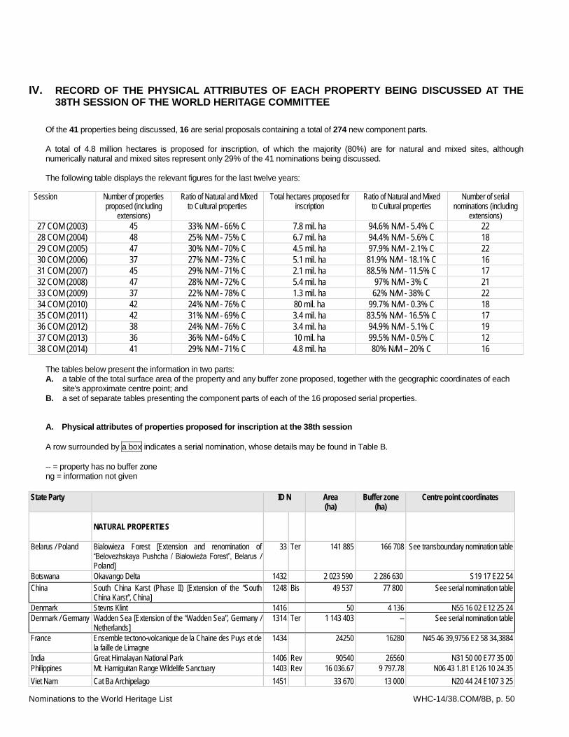
Nominations to the World Heritage List WHC-14/38.COM/8B, p. 50
IV. RECORD OF THE PHYSICAL ATTRIBUTES OF EACH PROPERTY BEING DISCUSSED AT THE 38TH SESSION OF THE WORLD HERITAGE COMMITTEE
Of the 41 properties being discussed, 16 are serial proposals containing a total of 274 new component parts. A total of 4.8 million hectares is proposed for inscription, of which the majority (80%) are for natural and mixed sites, although numerically natural and mixed sites represent only 29% of the 41 nominations being discussed. The following table displays the relevant figures for the last twelve years:
Session Number of properties proposed (including
extensions)
Ratio of Natural and Mixed to Cultural properties
Total hectares proposed for inscription
Ratio of Natural and Mixed to Cultural properties
Number of serial nominations (including
extensions) 27 COM (2003) 45 33% N/M - 66% C 7.8 mil. ha 94.6% N/M - 5.4% C 22 28 COM (2004) 48 25% N/M - 75% C 6.7 mil. ha 94.4% N/M - 5.6% C 18 29 COM (2005) 47 30% N/M - 70% C 4.5 mil. ha 97.9% N/M - 2.1% C 22 30 COM (2006) 37 27% N/M - 73% C 5.1 mil. ha 81.9% N/M - 18.1% C 16 31 COM (2007) 45 29% N/M - 71% C 2.1 mil. ha 88.5% N/M - 11.5% C 17 32 COM (2008) 47 28% N/M - 72% C 5.4 mil. ha 97% N/M - 3% C 21 33 COM (2009) 37 22% N/M - 78% C 1.3 mil. ha 62% N/M - 38% C 22 34 COM (2010) 42 24% N/M - 76% C 80 mil. ha 99.7% N/M - 0.3% C 18 35 COM (2011) 42 31% N/M - 69% C 3.4 mil. ha 83.5% N/M - 16.5% C 17 36 COM (2012) 38 24% N/M - 76% C 3.4 mil. ha 94.9% N/M - 5.1% C 19 37 COM (2013) 36 36% N/M - 64% C 10 mil. ha 99.5% N/M - 0.5% C 12 38 COM (2014) 41 29% N/M - 71% C 4.8 mil. ha 80% N/M – 20% C 16
The tables below present the information in two parts: A. a table of the total surface area of the property and any buffer zone proposed, together with the geographic coordinates of each
site's approximate centre point; and B. a set of separate tables presenting the component parts of each of the 16 proposed serial properties. A. Physical attributes of properties proposed for inscription at the 38th session A row surrounded by a box indicates a serial nomination, whose details may be found in Table B. -- = property has no buffer zone ng = information not given
State Party
ID N Area (ha)
Buffer zone (ha)
Centre point coordinates
NATURAL PROPERTIES
Belarus / Poland Bialowieza Forest [Extension and renomination of “Belovezhskaya Pushcha / Białowieża Forest”, Belarus / Poland]
33 Ter 141 885 166 708 See transboundary nomination table
Botswana Okavango Delta 1432 2 023 590 2 286 630 S19 17 E22 54 China South China Karst (Phase II) [Extension of the “South
China Karst”, China] 1248 Bis 49 537 77 800 See serial nomination table
Denmark Stevns Klint 1416 50 4 136 N55 16 02 E12 25 24 Denmark / Germany Wadden Sea [Extension of the “Wadden Sea”, Germany /
Netherlands] 1314 Ter 1 143 403 -- See serial nomination table
France Ensemble tectono-volcanique de la Chaine des Puys et de la faille de Limagne
1434 24250 16280 N45 46 39,9756 E2 58 34,3884
India Great Himalayan National Park 1406 Rev 90540 26560 N31 50 00 E77 35 00 Philippines Mt. Hamiguitan Range Wildelife Sanctuary 1403 Rev 16 036.67 9 797.78 N06 43 1.81 E126 10 24.35 Viet Nam Cat Ba Archipelago 1451 33 670 13 000 N20 44 24 E107 3 25
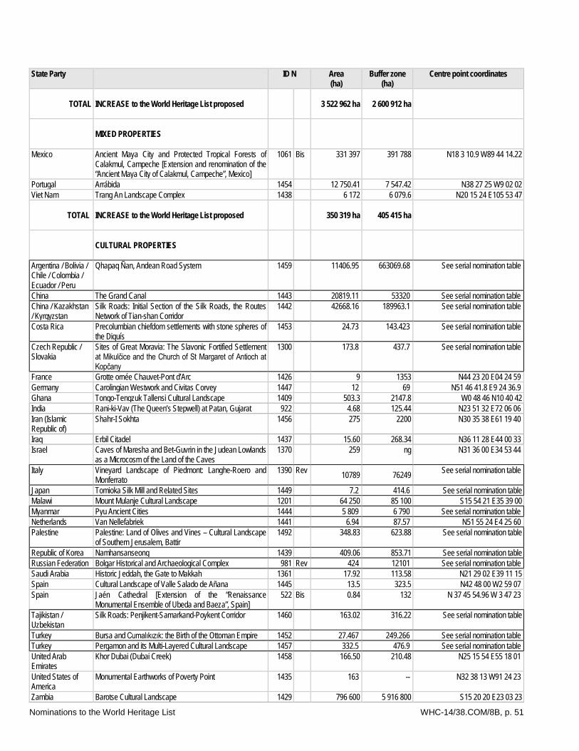
Nominations to the World Heritage List WHC-14/38.COM/8B, p. 51
State Party
ID N Area (ha)
Buffer zone (ha)
Centre point coordinates
TOTAL
INCREASE to the World Heritage List proposed
3 522 962 ha 2 600 912 ha
MIXED PROPERTIES
Mexico Ancient Maya City and Protected Tropical Forests of Calakmul, Campeche [Extension and renomination of the “Ancient Maya City of Calakmul, Campeche”, Mexico]
1061 Bis 331 397 391 788 N18 3 10.9 W89 44 14.22
Portugal Arrábida 1454 12 750.41 7 547.42 N38 27 25 W9 02 02 Viet Nam Trang An Landscape Complex 1438 6 172 6 079.6 N20 15 24 E105 53 47
TOTAL
INCREASE to the World Heritage List proposed
350 319 ha 405 415 ha
CULTURAL PROPERTIES
Argentina / Bolivia / Chile / Colombia / Ecuador / Peru
Qhapaq Ñan, Andean Road System 1459 11406.95 663069.68 See serial nomination table
China The Grand Canal 1443 20819.11 53320 See serial nomination table China / Kazakhstan / Kyrgyzstan
Silk Roads: Initial Section of the Silk Roads, the Routes Network of Tian-shan Corridor
1442 42668.16 189963.1 See serial nomination table
Costa Rica Precolumbian chiefdom settlements with stone spheres of the Diquís
1453 24.73 143.423 See serial nomination table
Czech Republic / Slovakia
Sites of Great Moravia: The Slavonic Fortified Settlement at Mikulčice and the Church of St Margaret of Antioch at Kopčany
1300 173.8 437.7 See serial nomination table
France Grotte ornée Chauvet-Pont d’Arc 1426 9 1353 N44 23 20 E04 24 59 Germany Carolingian Westwork and Civitas Corvey 1447 12 69 N51 46 41.8 E9 24 36.9 Ghana Tongo-Tengzuk Tallensi Cultural Landscape 1409 503.3 2147.8 W0 48 46 N10 40 42 India Rani-ki-Vav (The Queen’s Stepwell) at Patan, Gujarat 922 4.68 125.44 N23 51 32 E72 06 06 Iran (Islamic Republic of)
Shahr-I Sokhta 1456 275 2200 N30 35 38 E61 19 40
Iraq Erbil Citadel 1437 15.60 268.34 N36 11 28 E44 00 33 Israel Caves of Maresha and Bet-Guvrin in the Judean Lowlands
as a Microcosm of the Land of the Caves 1370 259 ng N31 36 00 E34 53 44
Italy Vineyard Landscape of Piedmont: Langhe-Roero and Monferrato
1390 Rev 10789 76249 See serial nomination table
Japan Tomioka Silk Mill and Related Sites 1449 7.2 414.6 See serial nomination table Malawi Mount Mulanje Cultural Landscape 1201 64 250 85 100 S15 54 21 E35 39 00 Myanmar Pyu Ancient Cities 1444 5 809 6 790 See serial nomination table Netherlands Van Nellefabriek 1441 6.94 87.57 N51 55 24 E4 25 60 Palestine Palestine: Land of Olives and Vines – Cultural Landscape
of Southern Jerusalem, Battir 1492 348.83 623.88 See serial nomination table
Republic of Korea Namhansanseong 1439 409.06 853.71 See serial nomination table Russian Federation Bolgar Historical and Archaeological Complex 981 Rev 424 12101 See serial nomination table Saudi Arabia Historic Jeddah, the Gate to Makkah 1361 17.92 113.58 N21 29 02 E39 11 15 Spain Cultural Landscape of Valle Salado de Añana 1445 13.5 323.5 N42 48 00 W2 59 07 Spain Jaén Cathedral [Extension of the “Renaissance
Monumental Ensemble of Ubeda and Baeza”, Spain] 522 Bis 0.84 132 N 37 45 54.96 W 3 47 23
Tajikistan / Uzbekistan
Silk Roads: Penjikent-Samarkand-Poykent Corridor 1460 163.02 316.22 See serial nomination table
Turkey Bursa and Cumalıkızık: the Birth of the Ottoman Empire 1452 27.467 249.266 See serial nomination table Turkey Pergamon and its Multi-Layered Cultural Landscape 1457 332.5 476.9 See serial nomination table United Arab Emirates
Khor Dubai (Dubai Creek) 1458 166.50 210.48 N25 15 54 E55 18 01
United States of America
Monumental Earthworks of Poverty Point 1435 163 -- N32 38 13 W91 24 23
Zambia Barotse Cultural Landscape 1429 796 600 5 916 800 S15 20 20 E23 03 23
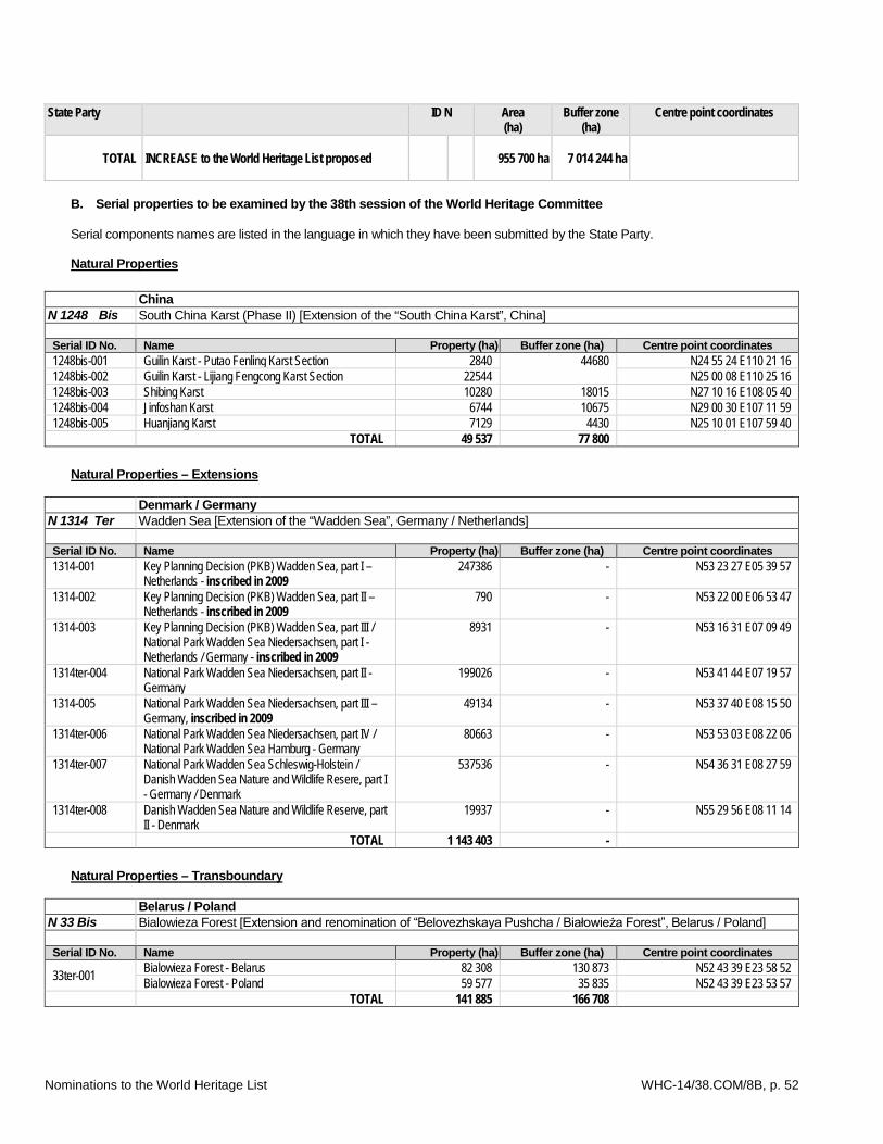
Nominations to the World Heritage List WHC-14/38.COM/8B, p. 52
State Party
ID N Area (ha)
Buffer zone (ha)
Centre point coordinates
TOTAL
INCREASE to the World Heritage List proposed
955 700 ha 7 014 244 ha
B. Serial properties to be examined by the 38th session of the World Heritage Committee Serial components names are listed in the language in which they have been submitted by the State Party. Natural Properties
China N 1248 Bis South China Karst (Phase II) [Extension of the “South China Karst”, China] Serial ID No. Name Property (ha) Buffer zone (ha) Centre point coordinates 1248bis-001 Guilin Karst - Putao Fenling Karst Section 2840 44680 N24 55 24 E110 21 16 1248bis-002 Guilin Karst - Lijiang Fengcong Karst Section 22544 N25 00 08 E110 25 16 1248bis-003 Shibing Karst 10280 18015 N27 10 16 E108 05 40 1248bis-004 Jinfoshan Karst 6744 10675 N29 00 30 E107 11 59 1248bis-005 Huanjiang Karst 7129 4430 N25 10 01 E107 59 40 TOTAL 49 537 77 800
Natural Properties – Extensions
Denmark / Germany N 1314 Ter Wadden Sea [Extension of the “Wadden Sea”, Germany / Netherlands] Serial ID No. Name Property (ha) Buffer zone (ha) Centre point coordinates 1314-001 Key Planning Decision (PKB) Wadden Sea, part I –
Netherlands - inscribed in 2009 247386 - N53 23 27 E05 39 57
1314-002 Key Planning Decision (PKB) Wadden Sea, part II – Netherlands - inscribed in 2009
790 - N53 22 00 E06 53 47
1314-003 Key Planning Decision (PKB) Wadden Sea, part III / National Park Wadden Sea Niedersachsen, part I - Netherlands / Germany - inscribed in 2009
8931 - N53 16 31 E07 09 49
1314ter-004 National Park Wadden Sea Niedersachsen, part II - Germany
199026 - N53 41 44 E07 19 57
1314-005 National Park Wadden Sea Niedersachsen, part III – Germany, inscribed in 2009
49134 - N53 37 40 E08 15 50
1314ter-006 National Park Wadden Sea Niedersachsen, part IV / National Park Wadden Sea Hamburg - Germany
80663 - N53 53 03 E08 22 06
1314ter-007 National Park Wadden Sea Schleswig-Holstein / Danish Wadden Sea Nature and Wildlife Resere, part I - Germany / Denmark
537536 - N54 36 31 E08 27 59
1314ter-008 Danish Wadden Sea Nature and Wildlife Reserve, part II - Denmark
19937 - N55 29 56 E08 11 14
TOTAL 1 143 403 - Natural Properties – Transboundary
Belarus / Poland N 33 Bis Bialowieza Forest [Extension and renomination of “Belovezhskaya Pushcha / Białowieża Forest”, Belarus / Poland] Serial ID No. Name Property (ha) Buffer zone (ha) Centre point coordinates
33ter-001 Bialowieza Forest - Belarus 82 308 130 873 N52 43 39 E23 58 52 Bialowieza Forest - Poland 59 577 35 835 N52 43 39 E23 53 57
TOTAL 141 885 166 708
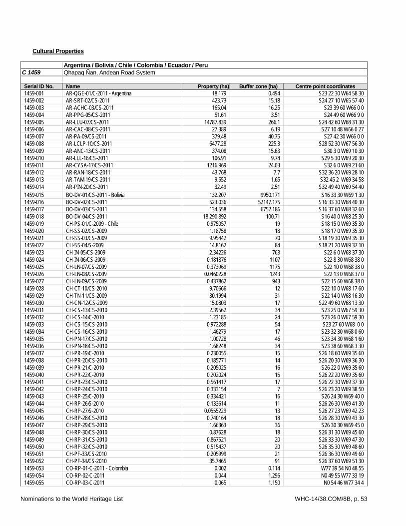
Nominations to the World Heritage List WHC-14/38.COM/8B, p. 53
Cultural Properties
Argentina / Bolivia / Chile / Colombia / Ecuador / Peru C 1459 Qhapaq Ñan, Andean Road System Serial ID No. Name Property (ha) Buffer zone (ha) Centre point coordinates 1459-001 AR-QGE-01/C-2011 - Argentina 18.179 0.494 S23 22 30 W64 58 30 1459-002 AR-SRT-02/CS-2011 423.73 15.18 S24 27 10 W65 57 40 1459-003 AR-ACHC-03/CS-2011 165.04 16.25 S23 39 60 W66 0 0 1459-004 AR-PPG-05/CS-2011 51.61 3.51 S24 49 60 W66 9 0 1459-005 AR-LLU-07/CS-2011 14787.839 266.1 S24 42 60 W68 31 30 1459-006 AR-CAC-08/CS-2011 27.389 6.19 S27 10 48 W66 0 27 1459-007 AR-PA-09/CS-2011 379.48 40.75 S27 42 30 W66 0 0 1459-008 AR-LCLP-10/CS-2011 6477.28 225.3 S28 52 30 W67 56 30 1459-009 AR-ANC-13/CS-2011 374.08 15.63 S30 3 0 W69 10 30 1459-010 AR-LLL-16/CS-2011 106.91 9.74 S29 5 30 W69 20 30 1459-011 AR-CYSA-17/CS-2011 1216.969 24.03 S32 6 0 W69 21 60 1459-012 AR-RAN-18/CS-2011 43.768 7.7 S32 36 20 W69 28 10 1459-013 AR-TAM-19/CS-2011 9.552 1.65 S32 45 2 W69 34 58 1459-014 AR-PIN-20/CS-2011 32.49 2.51 S32 49 40 W69 54 40 1459-015 BO-DV-01/CS-2011 - Bolivia 132.207 9950.171 S16 33 30 W69 1 30 1459-016 BO-DV-02/CS-2011 523.036 52147.175 S16 33 30 W68 40 30 1459-017 BO-DV-03/CS-2011 134.558 6752.186 S16 37 60 W68 32 60 1459-018 BO-DV-04/CS-2011 18 290.892 100.71 S16 40 0 W68 25 30 1459-019 CH-PS-01/C-2009 - Chile 0.975057 19 S18 15 0 W69 35 30 1459-020 CH-SS-02/CS-2009 1.18758 18 S18 17 0 W69 35 30 1459-021 CH-SS-03/CS-2009 9.95442 70 S18 19 30 W69 35 30 1459-022 CH-SS-04/S-2009 14.8162 84 S18 21 20 W69 37 10 1459-023 CH-IN-05/CS-2009 2.34226 763 S22 6 0 W68 37 30 1459-024 CH-IN-06/CS-2009 0.181876 1107 S22 8 30 W68 38 0 1459-025 CH-LN-07/CS-2009 0.373969 1175 S22 10 0 W68 38 0 1459-026 CH-LN-08/CS-2009 0.0460228 1243 S22 13 0 W68 37 0 1459-027 CH-LN-09/CS-2009 0.437862 943 S22 15 60 W68 38 0 1459-028 CH-CT-10/CS-2010 9.70666 12 S22 10 0 W68 17 60 1459-029 CH-TN-11/CS-2009 30.1994 31 S22 14 0 W68 16 30 1459-030 CH-CN-12/CS-2009 15.0803 17 S22 49 60 W68 13 30 1459-031 CH-CS-13/CS-2010 2.39562 34 S23 25 0 W67 59 30 1459-032 CH-CS-14/C-2010 1.23185 24 S23 26 0 W67 59 30 1459-033 CH-CS-15/CS-2010 0.972288 54 S23 27 60 W68 0 0 1459-034 CH-CS-16/CS-2010 1.46279 17 S23 32 30 W68 0 60 1459-035 CH-PN-17/CS-2010 1.00728 46 S23 34 30 W68 1 60 1459-036 CH-PN-18/CS-2010 1.68248 34 S23 38 60 W68 3 30 1459-037 CH-PR-19/C-2010 0.230055 15 S26 18 60 W69 35 60 1459-038 CH-PR-20/CS-2010 0.185771 14 S26 20 30 W69 36 30 1459-039 CH-PR-21/C-2010 0.205025 16 S26 22 0 W69 35 60 1459-040 CH-PR-22/C-2010 0.202024 15 S26 22 20 W69 35 60 1459-041 CH-PR-23/CS-2010 0.561417 17 S26 22 30 W69 37 30 1459-042 CH-RP-24/CS-2010 0.333154 7 S26 23 20 W69 38 50 1459-043 CH-RP-25/C-2010 0.334421 16 S26 24 30 W69 40 0 1459-044 CH-RP-26/S-2010 0.133614 11 S26 26 30 W69 41 30 1459-045 CH-RP-27/S-2010 0.0555229 13 S26 27 23 W69 42 23 1459-046 CH-RP-28/CS-2010 0.740164 18 S26 28 30 W69 43 30 1459-047 CH-RP-29/CS-2010 1.66363 36 S26 30 30 W69 45 0 1459-048 CH-RP-30/CS-2010 0.87628 18 S26 31 30 W69 45 60 1459-049 CH-RP-31/CS-2010 0.867521 20 S26 33 30 W69 47 30 1459-050 CH-RP-32/CS-2010 0.515437 20 S26 35 30 W69 48 60 1459-051 CH-PF-33/CS-2010 0.205999 21 S26 36 30 W69 49 60 1459-052 CH-PF-34/CS-2010 35.7465 91 S26 37 60 W69 51 30 1459-053 CO-RP-01-C-2011 - Colombia 0.002 0.114 W77 39 54 N0 48 55 1459-054 CO-RP-02-C-2011 0.044 1.296 N0 49 55 W77 33 19 1459-055 CO-RP-03-C-2011 0.065 1.150 N0 54 46 W77 34 4
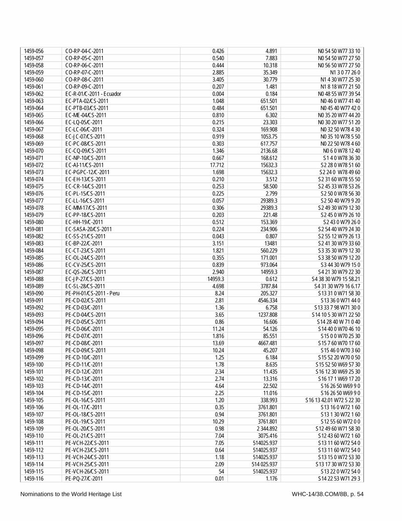
Nominations to the World Heritage List WHC-14/38.COM/8B, p. 54
1459-056 CO-RP-04-C-2011 0.426 4.891 N0 54 50 W77 33 10 1459-057 CO-RP-05-C-2011 0.540 7.883 N0 54 50 W77 27 50 1459-058 CO-RP-06-C-2011 0.444 10.318 N0 56 50 W77 27 50 1459-059 CO-RP-07-C-2011 2.885 35.349 N1 3 0 77 26 0 1459-060 CO-RP-08-C-2011 3.405 30.779 N1 4 30 W77 25 30 1459-061 CO-RP-09-C-2011 0.207 1.481 N1 8 18 W77 21 50 1459-062 EC-R-01/C-2011 - Ecuador 0.004 0.184 N0 48 55 W77 39 54 1459-063 EC-PTA-02/CS-2011 1.048 651.501 N0 46 0 W77 41 40 1459-064 EC-PTB-03/CS-2011 0.484 651.501 N0 45 40 W77 42 0 1459-065 EC-ME-04/CS-2011 0.810 6.302 N0 35 20 W77 44 20 1459-066 EC-LQ-05/C-2011 0.215 23.303 N0 30 20 W77 51 20 1459-067 EC-LC-06/C-2011 0.324 169.908 N0 32 50 W78 4 30 1459-068 EC-JC-07/CS-2011 0.919 1053.75 N0 35 10 W78 5 50 1459-069 EC-PC-08/CS-2011 0.303 617.757 N0 22 50 W78 4 60 1459-070 EC-CQ-09/CS-2011 1.346 2136.68 N0 6 0 W78 12 40 1459-071 EC-NP-10/CS-2011 0.667 168.612 S1 4 0 W78 36 30 1459-072 EC-AI-11/CS-2011 17.712 15632.3 S2 28 0 W78 51 60 1459-073 EC-PGPC-12/C-2011 1.698 15632.3 S2 24 0 W78 49 60 1459-074 EC-EH-13/CS-2011 0.210 3.512 S2 31 60 W78 55 50 1459-075 EC-CR-14/CS-2011 0.253 58.500 S2 45 33 W78 53 26 1459-076 EC-PL-15/CS-2011 0.225 2.799 S2 50 0 W78 56 30 1459-077 EC-LL-16/CS-2011 0.057 29389.3 S2 50 40 W79 9 20 1459-078 EC-MM-17/CS-2011 0.306 29389.3 S2 49 30 W79 12 30 1459-079 EC-PP-18/CS-2011 0.203 221.48 S2 45 0 W79 26 10 1459-080 EC-HH-19/C-2011 0.512 153.369 S2 43 0 W79 26 0 1459-081 EC-SASA-20/CS-2011 0.224 234.906 S2 54 40 W79 24 30 1459-082 EC-SS-21/CS-2011 0.043 0.807 S2 55 12 W79 26 13 1459-083 EC-BP-22/C-2011 3.151 13481 S2 41 30 W79 33 60 1459-084 EC-CT-23/CS-2011 1.821 560.229 S3 35 30 W79 12 30 1459-085 EC-OL-24/CS-2011 0.355 171.001 S3 38 50 W79 12 20 1459-086 EC-CV-25/CS-2011 0.839 973.064 S3 44 30 W79 15 0 1459-087 EC-QS-26/CS-2011 2.940 14959.3 S4 21 30 W79 22 30 1459-088 EC-JP-27/CS-2011 14959.3 0.612 S4 38 30 W79 15 58.21 1459-089 EC-SL-28/CS-2011 4.698 3787.84 S4 31 30 W79 16 6.17 1459-090 PE-PH-01/CS-2011 - Peru 8.24 205.327 S13 31 0 W71 58 30 1459-091 PE-CD-02/CS-2011 2.81 4546.334 S13 36 0 W71 44 0 1459-092 PE-CD-03/C-2011 1.36 6.758 S13 33 7 98 W71 30 0 1459-093 PE-CD-04/CS-2011 3.65 1237.808 S14 10 5 30 W71 22 50 1459-094 PE-CD-05/CS-2011 0.86 16.606 S14 28 40 W 71 0 40 1459-095 PE-CD-06/C-2011 11.24 54.126 S14 40 0 W70 46 10 1459-096 PE-CD-07/C-2011 1.816 85.551 S15 0 0 W70 25 30 1459-097 PE-CD-08/C-2011 13.69 4667.481 S15 7 60 W70 17 60 1459-098 PE-CD-09/CS-2011 10.24 45.207 S15 46 0 W70 3 60 1459-099 PE-CD-10/C-2011 1.25 6.184 S15 52 20 W70 0 50 1459-100 PE-CD-11/C-2011 1.78 8.635 S15 52 50 W69 57 30 1459-101 PE-CD-12/C-2011 2.34 11.435 S16 12 30 W69 25 30 1459-102 PE-CD-13/C-2011 2.74 13.316 S16 17 1 W69 17 20 1459-103 PE-CD-14/C-2011 4.64 22.502 S16 26 50 W69 9 0 1459-104 PE-CD-15/C-2011 2.25 11.016 S16 26 50 W69 9 0 1459-105 PE-OL-16/CS-2011 1.20 338.993 S16 13 42.01 W72 5 22 30 1459-106 PE-OL-17/C-2011 0.35 3761.801 S13 16 0 W72 1 60 1459-107 PE-OL-18/CS-2011 0.94 3761.801 S13 1 30 W72 1 60 1459-108 PE-OL-19/CS-2011 10.29 3761.801 S12 55 60 W72 0 0 1459-109 PE-OL-20/CS-2011 0.98 2 344.892 S12 49 60 W71 58 30 1459-110 PE-OL-21/CS-2011 7.04 3075.416 S12 43 60 W72 1 60 1459-111 PE-VCH-22/CS-2011 7.05 514025.937 S13 11 60 W72 54 0 1459-112 PE-VCH-23/CS-2011 0.64 514025.937 S13 11 60 W72 54 0 1459-113 PE-VCH-24/CS-2011 1.18 514025.937 S13 15 0 W72 53 30 1459-114 PE-VCH-25/CS-2011 2.09 514 025.937 S13 17 30 W72 53 30 1459-115 PE-VCH-26/CS-2011 54 514025.937 S13 22 0 W72 54 0 1459-116 PE-PQ-27/C-2011 0.01 1.176 S14 22 53 W71 29 3
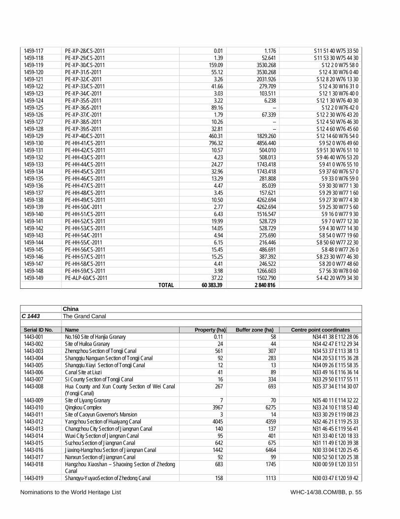
Nominations to the World Heritage List WHC-14/38.COM/8B, p. 55
1459-117 PE-XP-28/CS-2011 0.01 1.176 S11 51 40 W75 33 50 1459-118 PE-XP-29/CS-2011 1.39 52.641 S11 53 30 W75 44 30 1459-119 PE-XP-30/CS-2011 159.09 3530.268 S12 2 0 W75 58 0 1459-120 PE-XP-31/S-2011 55.12 3530.268 S12 4 30 W76 0 40 1459-121 PE-XP-32/C-2011 3.26 2031.926 S12 8 20 W76 13 30 1459-122 PE-XP-33/CS-2011 41.66 279.709 S12 4 30 W16 31 0 1459-123 PE-XP-34/C-2011 3.03 103.511 S12 1 30 W76 40 0 1459-124 PE-XP-35/S-2011 3.22 6.238 S12 1 30 W76 40 30 1459-125 PE-XP-36/S-2011 89.16 -- S12 2 0 W76 42 0 1459-126 PE-XP-37/C-2011 1.79 67.339 S12 2 30 W76 43 20 1459-127 PE-XP-38/S-2011 10.26 -- S12 4 50 W76 46 30 1459-128 PE-XP-39/S-2011 32.81 -- S12 4 60 W76 45 60 1459-129 PE-XP-40/CS-2011 460.31 1829.260 S12 14 60 W76 54 0 1459-130 PE-HH-41/CS-2011 796.32 4856.440 S9 52 0 W76 49 60 1459-131 PE-HH-42/CS-2011 10.57 504.010 S9 51 30 W76 51 10 1459-132 PE-HH-43/CS-2011 4.23 508.013 S9 46 40 W76 53 20 1459-133 PE-HH-44/CS-2011 24.27 1743.418 S9 41 0 W76 55 10 1459-134 PE-HH-45/CS-2011 32.96 1743.418 S9 37 60 W76 57 0 1459-135 PE-HH-46/CS-2011 13.29 281.808 S9 33 0 W76 59 0 1459-136 PE-HH-47/CS-2011 4.47 85.039 S9 30 30 W77 1 30 1459-137 PE-HH-48/CS-2011 3.45 157.621 S9 29 30 W77 1 60 1459-138 PE-HH-49/CS-2011 10.50 4262.694 S9 27 30 W77 4 30 1459-139 PE-HH-50/C-2011 2.77 4262.694 S9 25 30 W77 5 60 1459-140 PE-HH-51/CS-2011 6.43 1516.547 S9 16 0 W77 9 30 1459-141 PE-HH-52/CS-2011 19.99 528.729 S9 7 0 W77 12 30 1459-142 PE-HH-53/CS-2011 14.05 528.729 S9 4 30 W77 14 30 1459-143 PE-HH-54/C-2011 4.94 275.690 S8 54 0 W77 19 60 1459-144 PE-HH-55/C-2011 6.15 216.446 S8 50 60 W77 22 30 1459-145 PE-HH-56/CS-2011 15.45 486.691 S8 48 0 W77 26 0 1459-146 PE-HH-57/CS-2011 15.25 387.392 S8 23 30 W77 46 30 1459-147 PE-HH-58/CS-2011 4.41 246.522 S8 20 0 W77 48 60 1459-148 PE-HH-59/CS-2011 3.98 1266.603 S7 56 30 W78 0 60 1459-149 PE-ALP-60/CS-2011 37.22 1502.790 S4 42 20 W79 34 30 TOTAL 60 383.39 2 840 816
China C 1443 The Grand Canal Serial ID No. Name Property (ha) Buffer zone (ha) Centre point coordinates 1443-001 No.160 Site of Hanjia Granary 0.11 58 N34 41 38 E112 28 06 1443-002 Site of Huiloa Granary 24 44 N34 42 47 E112 29 34 1443-003 Zhengzhou Section of Tongji Canal 561 307 N34 53 37 E113 38 13 1443-004 Shangqiu Nanguan Section of Tongji Canal 92 283 N34 20 53 E115 36 28 1443-005 Shangqiu Xiayi Section of Tongji Canal 12 13 N34 09 26 E115 58 35 1443-006 Canal Site at Liuzi 41 89 N33 49 16 E116 36 14 1443-007 Si County Section of Tongji Canal 16 334 N33 29 50 E117 55 11 1443-008 Hua County and Xun County Section of Wei Canal
(Yongji Canal) 267 693 N35 37 34 E114 30 07
1443-009 Site of Liyang Granary 7 70 N35 40 11 E114 32 22 1443-010 Qingkou Complex 3967 6275 N33 24 10 E118 53 40 1443-011 Site of Caoyun Governor’s Mansion 3 14 N33 30 29 E119 08 23 1443-012 Yangzhou Section of Huaiyang Canal 4045 4359 N32 46 21 E119 25 33 1443-013 Changzhou City Section of Jiangnan Canal 140 137 N31 46 45 E119 56 41 1443-014 Wuxi City Section of Jiangnan Canal 95 401 N31 33 40 E120 18 33 1443-015 Suzhou Section of Jiangnan Canal 642 675 N31 11 49 E120 39 38 1443-016 Jiaxing-Hangzhou Section of Jiangnan Canal 1442 6464 N30 33 04 E120 25 45 1443-017 Nanxun Section of Jiangnan Canal 92 99 N30 52 50 E120 25 38 1443-018 Hangzhou Xiaoshan – Shaoxing Section of Zhedong
Canal 683 1745 N30 00 59 E120 33 51
1443-019 Shangyu-YuyaoSection of Zhedong Canal 158 1113 N30 03 47 E120 59 42
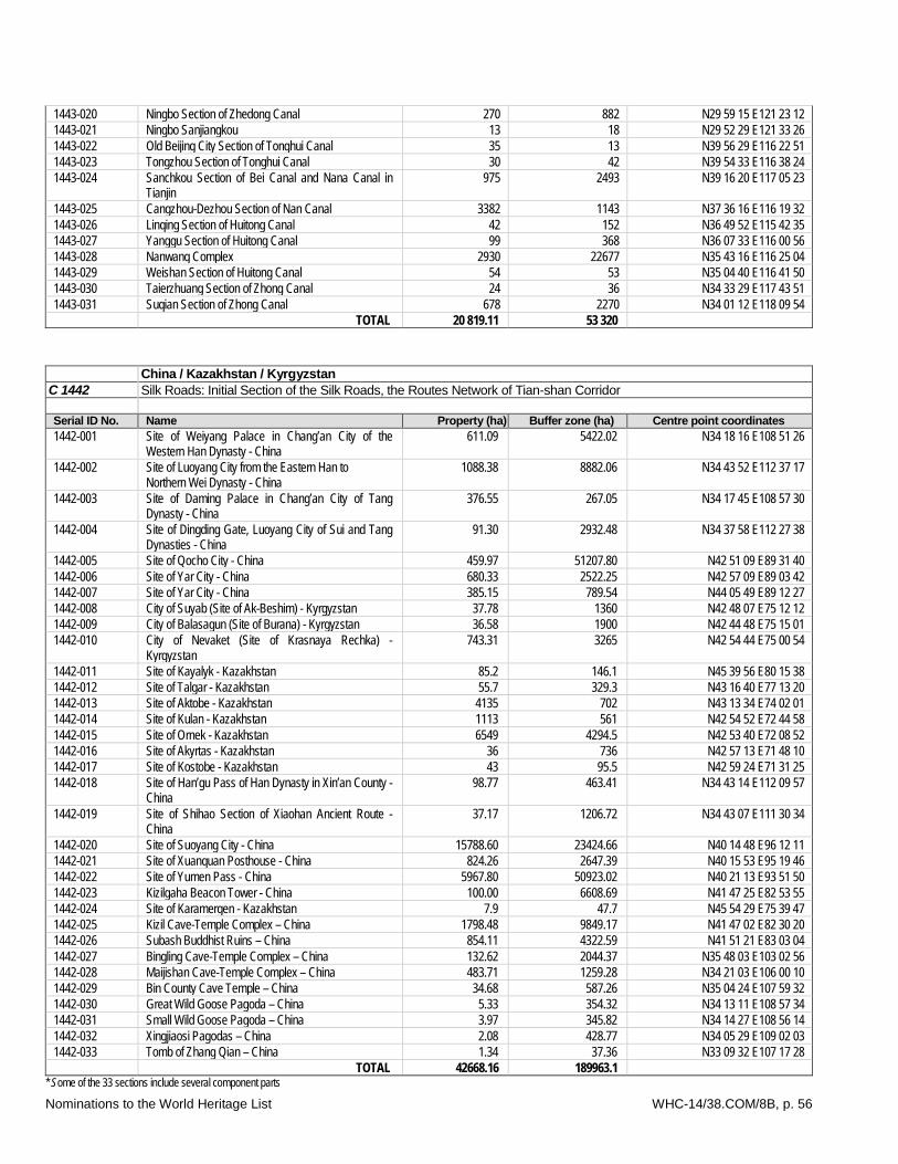
Nominations to the World Heritage List WHC-14/38.COM/8B, p. 56
1443-020 Ningbo Section of Zhedong Canal 270 882 N29 59 15 E121 23 12 1443-021 Ningbo Sanjiangkou 13 18 N29 52 29 E121 33 26 1443-022 Old Beijing City Section of Tonghui Canal 35 13 N39 56 29 E116 22 51 1443-023 Tongzhou Section of Tonghui Canal 30 42 N39 54 33 E116 38 24 1443-024 Sanchkou Section of Bei Canal and Nana Canal in
Tianjin 975 2493 N39 16 20 E117 05 23
1443-025 Cangzhou-Dezhou Section of Nan Canal 3382 1143 N37 36 16 E116 19 32 1443-026 Linqing Section of Huitong Canal 42 152 N36 49 52 E115 42 35 1443-027 Yanggu Section of Huitong Canal 99 368 N36 07 33 E116 00 56 1443-028 Nanwang Complex 2930 22677 N35 43 16 E116 25 04 1443-029 Weishan Section of Huitong Canal 54 53 N35 04 40 E116 41 50 1443-030 Taierzhuang Section of Zhong Canal 24 36 N34 33 29 E117 43 51 1443-031 Suqian Section of Zhong Canal 678 2270 N34 01 12 E118 09 54 TOTAL 20 819.11 53 320
China / Kazakhstan / Kyrgyzstan C 1442 Silk Roads: Initial Section of the Silk Roads, the Routes Network of Tian-shan Corridor Serial ID No. Name Property (ha) Buffer zone (ha) Centre point coordinates 1442-001 Site of Weiyang Palace in Chang’an City of the
Western Han Dynasty - China 611.09 5422.02 N34 18 16 E108 51 26
1442-002 Site of Luoyang City from the Eastern Han to Northern Wei Dynasty - China
1088.38 8882.06 N34 43 52 E112 37 17
1442-003 Site of Daming Palace in Chang’an City of Tang Dynasty - China
376.55 267.05 N34 17 45 E108 57 30
1442-004 Site of Dingding Gate, Luoyang City of Sui and Tang Dynasties - China
91.30 2932.48 N34 37 58 E112 27 38
1442-005 Site of Qocho City - China 459.97 51207.80 N42 51 09 E89 31 40 1442-006 Site of Yar City - China 680.33 2522.25 N42 57 09 E89 03 42 1442-007 Site of Yar City - China 385.15 789.54 N44 05 49 E89 12 27 1442-008 City of Suyab (Site of Ak-Beshim) - Kyrgyzstan 37.78 1360 N42 48 07 E75 12 12 1442-009 City of Balasagun (Site of Burana) - Kyrgyzstan 36.58 1900 N42 44 48 E75 15 01 1442-010 City of Nevaket (Site of Krasnaya Rechka) -
Kyrgyzstan 743.31 3265 N42 54 44 E75 00 54
1442-011 Site of Kayalyk - Kazakhstan 85.2 146.1 N45 39 56 E80 15 38 1442-012 Site of Talgar - Kazakhstan 55.7 329.3 N43 16 40 E77 13 20 1442-013 Site of Aktobe - Kazakhstan 4135 702 N43 13 34 E74 02 01 1442-014 Site of Kulan - Kazakhstan 1113 561 N42 54 52 E72 44 58 1442-015 Site of Ornek - Kazakhstan 6549 4294.5 N42 53 40 E72 08 52 1442-016 Site of Akyrtas - Kazakhstan 36 736 N42 57 13 E71 48 10 1442-017 Site of Kostobe - Kazakhstan 43 95.5 N42 59 24 E71 31 25 1442-018 Site of Han’gu Pass of Han Dynasty in Xin’an County -
China 98.77 463.41 N34 43 14 E112 09 57
1442-019 Site of Shihao Section of Xiaohan Ancient Route - China
37.17 1206.72 N34 43 07 E111 30 34
1442-020 Site of Suoyang City - China 15788.60 23424.66 N40 14 48 E96 12 11 1442-021 Site of Xuanquan Posthouse - China 824.26 2647.39 N40 15 53 E95 19 46 1442-022 Site of Yumen Pass - China 5967.80 50923.02 N40 21 13 E93 51 50 1442-023 Kizilgaha Beacon Tower - China 100.00 6608.69 N41 47 25 E82 53 55 1442-024 Site of Karamergen - Kazakhstan 7.9 47.7 N45 54 29 E75 39 47 1442-025 Kizil Cave-Temple Complex – China 1798.48 9849.17 N41 47 02 E82 30 20 1442-026 Subash Buddhist Ruins – China 854.11 4322.59 N41 51 21 E83 03 04 1442-027 Bingling Cave-Temple Complex – China 132.62 2044.37 N35 48 03 E103 02 56 1442-028 Maijishan Cave-Temple Complex – China 483.71 1259.28 N34 21 03 E106 00 10 1442-029 Bin County Cave Temple – China 34.68 587.26 N35 04 24 E107 59 32 1442-030 Great Wild Goose Pagoda – China 5.33 354.32 N34 13 11 E108 57 34 1442-031 Small Wild Goose Pagoda – China 3.97 345.82 N34 14 27 E108 56 14 1442-032 Xingjiaosi Pagodas – China 2.08 428.77 N34 05 29 E109 02 03 1442-033 Tomb of Zhang Qian – China 1.34 37.36 N33 09 32 E107 17 28 TOTAL 42668.16 189963.1
* Some of the 33 sections include several component parts
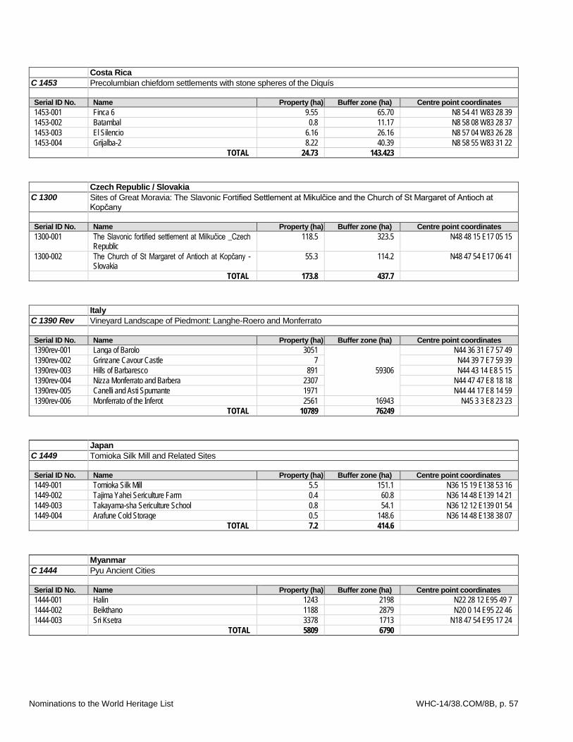
Nominations to the World Heritage List WHC-14/38.COM/8B, p. 57
Costa Rica C 1453 Precolumbian chiefdom settlements with stone spheres of the Diquís Serial ID No. Name Property (ha) Buffer zone (ha) Centre point coordinates 1453-001 Finca 6 9.55 65.70 N8 54 41 W83 28 39 1453-002 Batambal 0.8 11.17 N8 58 08 W83 28 37 1453-003 El Silencio 6.16 26.16 N8 57 04 W83 26 28 1453-004 Grijalba-2 8.22 40.39 N8 58 55 W83 31 22 TOTAL 24.73 143.423
Czech Republic / Slovakia C 1300 Sites of Great Moravia: The Slavonic Fortified Settlement at Mikulčice and the Church of St Margaret of Antioch at
Kopčany Serial ID No. Name Property (ha) Buffer zone (ha) Centre point coordinates 1300-001 The Slavonic fortified settlement at Milkučice _Czech
Republic 118.5 323.5 N48 48 15 E17 05 15
1300-002 The Church of St Margaret of Antioch at Kopčany - Slovakia
55.3 114.2 N48 47 54 E17 06 41
TOTAL 173.8 437.7 Italy C 1390 Rev Vineyard Landscape of Piedmont: Langhe-Roero and Monferrato Serial ID No. Name Property (ha) Buffer zone (ha) Centre point coordinates 1390rev-001 Langa of Barolo 3051
59306
N44 36 31 E7 57 49 1390rev-002 Grinzane Cavour Castle 7 N44 39 7 E7 59 39 1390rev-003 Hills of Barbaresco 891 N44 43 14 E8 5 15 1390rev-004 Nizza Monferrato and Barbera 2307 N44 47 47 E8 18 18 1390rev-005 Canelli and Asti Spumante 1971 N44 44 17 E8 14 59 1390rev-006 Monferrato of the Inferot 2561 16943 N45 3 3 E8 23 23 TOTAL 10789 76249
Japan C 1449 Tomioka Silk Mill and Related Sites Serial ID No. Name Property (ha) Buffer zone (ha) Centre point coordinates 1449-001 Tomioka Silk Mill 5.5 151.1 N36 15 19 E138 53 16 1449-002 Tajima Yahei Sericulture Farm 0.4 60.8 N36 14 48 E139 14 21 1449-003 Takayama-sha Sericulture School 0.8 54.1 N36 12 12 E139 01 54 1449-004 Arafune Cold Storage 0.5 148.6 N36 14 48 E138 38 07 TOTAL 7.2 414.6
Myanmar C 1444 Pyu Ancient Cities Serial ID No. Name Property (ha) Buffer zone (ha) Centre point coordinates 1444-001 Halin 1243 2198 N22 28 12 E95 49 7 1444-002 Beikthano 1188 2879 N20 0 14 E95 22 46 1444-003 Sri Ksetra 3378 1713 N18 47 54 E95 17 24
TOTAL 5809 6790
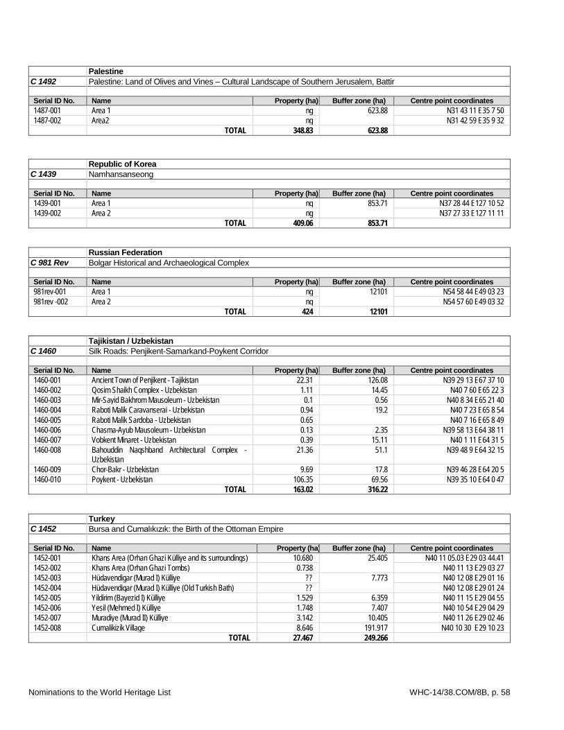
Nominations to the World Heritage List WHC-14/38.COM/8B, p. 58
Palestine C 1492 Palestine: Land of Olives and Vines – Cultural Landscape of Southern Jerusalem, Battir Serial ID No. Name Property (ha) Buffer zone (ha) Centre point coordinates 1487-001 Area 1 ng 623.88 N31 43 11 E35 7 50 1487-002 Area2 ng N31 42 59 E35 9 32 TOTAL 348.83 623.88
Republic of Korea C 1439 Namhansanseong Serial ID No. Name Property (ha) Buffer zone (ha) Centre point coordinates 1439-001 Area 1 ng 853.71 N37 28 44 E127 10 52 1439-002 Area 2 ng N37 27 33 E127 11 11 TOTAL 409.06 853.71
Russian Federation C 981 Rev Bolgar Historical and Archaeological Complex Serial ID No. Name Property (ha) Buffer zone (ha) Centre point coordinates 981rev-001 Area 1 ng 12101 N54 58 44 E49 03 23 981rev -002 Area 2 ng N54 57 60 E49 03 32 TOTAL 424 12101
Tajikistan / Uzbekistan C 1460 Silk Roads: Penjikent-Samarkand-Poykent Corridor Serial ID No. Name Property (ha) Buffer zone (ha) Centre point coordinates 1460-001 Ancient Town of Penjikent - Tajikistan 22.31 126.08 N39 29 13 E67 37 10 1460-002 Qosim Shaikh Complex - Uzbekistan 1.11 14.45 N40 7 60 E65 22 3 1460-003 Mir-Sayid Bakhrom Mausoleum - Uzbekistan 0.1 0.56 N40 8 34 E65 21 40 1460-004 Raboti Malik Caravanserai - Uzbekistan 0.94 19.2 N40 7 23 E65 8 54 1460-005 Raboti Malik Sardoba - Uzbekistan 0.65 N40 7 16 E65 8 49 1460-006 Chasma-Ayub Mausoleum - Uzbekistan 0.13 2.35 N39 58 13 E64 38 11 1460-007 Vobkent Minaret - Uzbekistan 0.39 15.11 N40 1 11 E64 31 5 1460-008 Bahouddin Naqshband Architectural Complex -
Uzbekistan 21.36 51.1 N39 48 9 E64 32 15
1460-009 Chor-Bakr - Uzbekistan 9.69 17.8 N39 46 28 E64 20 5 1460-010 Poykent - Uzbekistan 106.35 69.56 N39 35 10 E64 0 47 TOTAL 163.02 316.22
Turkey C 1452 Bursa and Cumalıkızık: the Birth of the Ottoman Empire Serial ID No. Name Property (ha) Buffer zone (ha) Centre point coordinates 1452-001 Khans Area (Orhan Ghazi Külliye and its surroundings) 10.680 25.405 N40 11 05.03 E29 03 44.41 1452-002 Khans Area (Orhan Ghazi Tombs) 0.738 N40 11 13 E29 03 27 1452-003 Hüdavendigar (Murad I) Külliye ?? 7.773 N40 12 08 E29 01 16 1452-004 Hüdavendigar (Murad I) Külliye (Old Turkish Bath) ?? N40 12 08 E29 01 24 1452-005 Yildirim (Bayezid I) Külliye 1.529 6.359 N40 11 15 E29 04 55 1452-006 Yesil (Mehmed I) Külliye 1.748 7.407 N40 10 54 E29 04 29 1452-007 Muradiye (Murad II) Külliye 3.142 10.405 N40 11 26 E29 02 46 1452-008 Cumalikizik Village 8.646 191.917 N40 10 30 E29 10 23 TOTAL 27.467 249.266
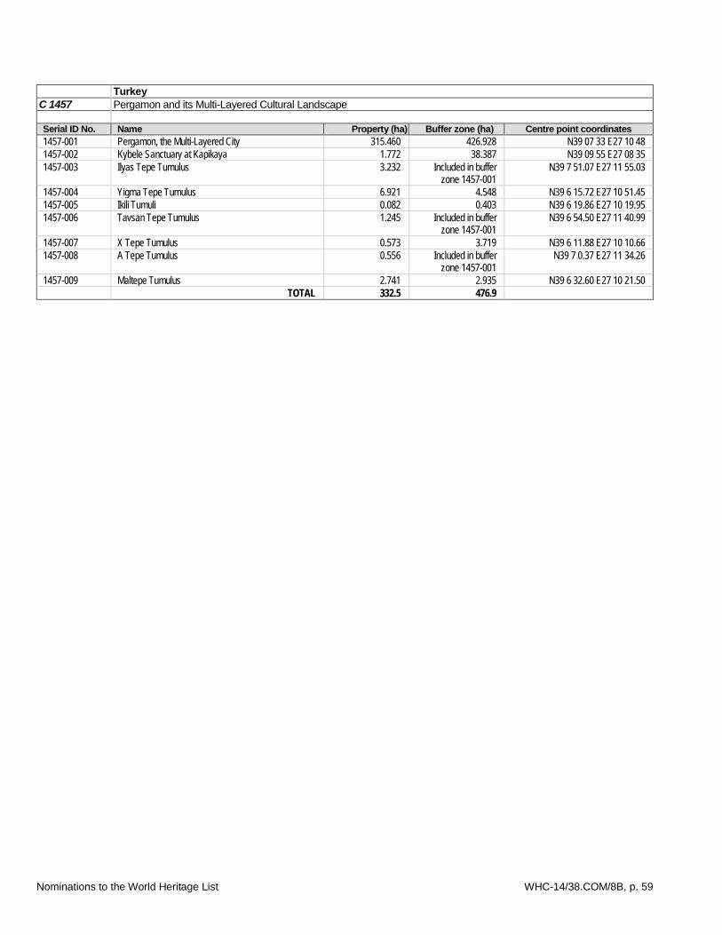
Nominations to the World Heritage List WHC-14/38.COM/8B, p. 59
Turkey C 1457 Pergamon and its Multi-Layered Cultural Landscape Serial ID No. Name Property (ha) Buffer zone (ha) Centre point coordinates 1457-001 Pergamon, the Multi-Layered City 315.460 426.928 N39 07 33 E27 10 48 1457-002 Kybele Sanctuary at Kapikaya 1.772 38.387 N39 09 55 E27 08 35 1457-003 Ilyas Tepe Tumulus 3.232 Included in buffer
zone 1457-001 N39 7 51.07 E27 11 55.03
1457-004 Yigma Tepe Tumulus 6.921 4.548 N39 6 15.72 E27 10 51.45 1457-005 Ikili Tumuli 0.082 0.403 N39 6 19.86 E27 10 19.95 1457-006 Tavsan Tepe Tumulus 1.245 Included in buffer
zone 1457-001 N39 6 54.50 E27 11 40.99
1457-007 X Tepe Tumulus 0.573 3.719 N39 6 11.88 E27 10 10.66 1457-008 A Tepe Tumulus 0.556 Included in buffer
zone 1457-001 N39 7 0.37 E27 11 34.26
1457-009 Maltepe Tumulus 2.741 2.935 N39 6 32.60 E27 10 21.50 TOTAL 332.5 476.9