Embed Size (px)
Citation preview
World Water Diplomacy & Science News- 2019 -10001
1
World Water Diplomacy & Science News
ENISSN : 12019-10009 www.hidropolitikakademi.org
How the Aral Sea Will Look Like in Foreseeable Future ?
Dursun Yıldız
Director
Hydropolitics Academy
SUMMARY
In 2011, Together with Ambassador (R) and Hydropolitical Academy founding Member M.
Nuri Yildirim we made a technical trip to Central Asia .In this trip 2 hours after we left
Kızılorda city to reach Aral Sea , we began to witness the great damage caused to the
environment by drying a lake along the dirt road. As the water was drawn from the sea, it also
took away the ecological balance. Because of the strong winds in the region, salt and drugs in
the vicinity of the lake spread very alarmingly, this problem was felt in the capital of
Uzbekistan, Tashkent, which is 500 km away.In this article I'm looking for an answer to the
question of whether the Aral Sea will go back or not.
Keywords : Aral Sea, Environmental Disater,
World Water Diplomacy & Science News- 2019 -10001
2
1. Introduction
Since the 1960s, the Aral Sea has been severely shrunk due to the excessive use of water
resources that feed the lake in the period of USSR for agricultural irrigation. This decrease in
the amount of water in the Aral Lake brought many ecological problems for the lake and its
surroundings. The area of 33.000 km2 in Aral Lake is completely dried and the mineral
content in its water is increased. The lake ecosystem is almost completely destroyed.
In the period between 1911 and 1960, an annual average of 56 billion m3 of water was spilled
on the Aral Sea. Since the mid - 1980s, the decline in the Aral Sea water volume has
accelerated. It was divided into two part in December 1987. The depth of the small Aral to the
north dropped to 12 m. The depth of the Great Aral in the south dropped to 23 m. The Aral
Lake, on this date, shrank by 74% in area and 84% in volume .
The area of Aral Lake, which was 67 500 km2 in 1960, decreased to 17 200 km2 in 2003. The
most populous countries in the region are also the most industrialized countries. For this
reason, these countries need important water to feed their populations as well as to provide
water to their industries.
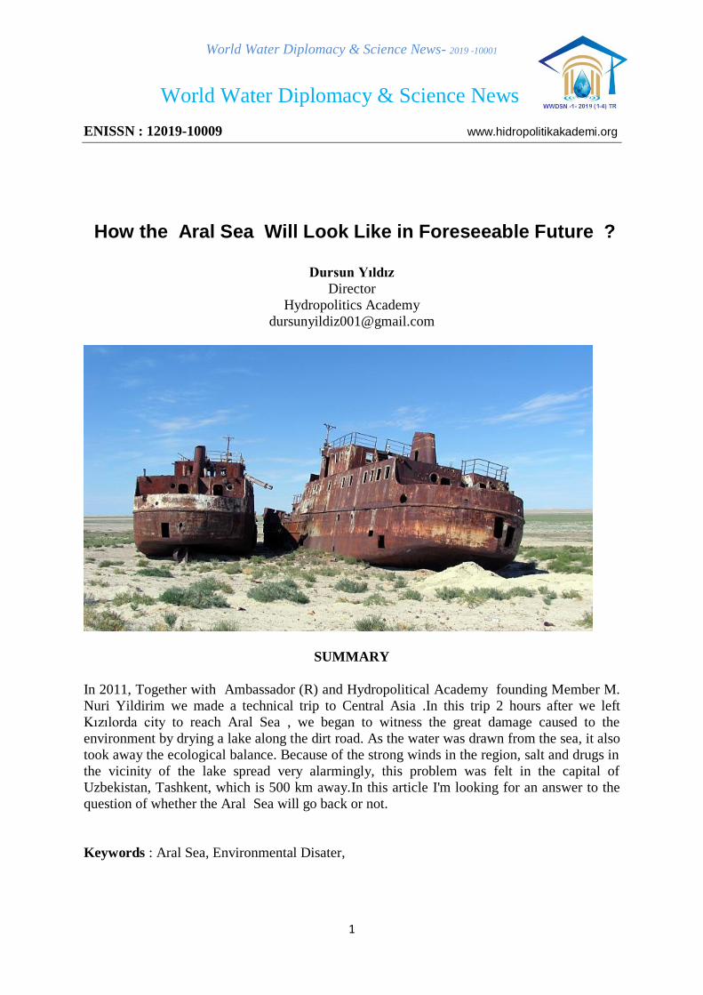
Ambassador (R) Nuri Yıldırım and Dursun Yıldız at Kok -Aral Dam –(Kazakhistan 2011)
Related with Aral Sea environmental disaster, the protection of the environment in Central
Asia encountered two obstacles. The first of these is addressing human needs in front of
environmental protection which remain from the period of USSR and the economic obstacle.
World Water Diplomacy & Science News- 2019 -10001
3
The amount of water flowing into the Aral Lake declined rapidly and in 2000 and 2001 The
measured average annual flow at observation station located 102 km. far away from the sea
showed that discharge was too low to feed the lake.
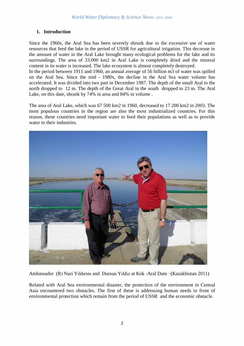
2. The Aral Sea was Seperated Into two Part
Because of the decrease in the amount of water flowing into the Aral Sea, the lake was
seperated into two part in 1998 as the Northern Aral and Southern Aral.The eastern part of the
southern Aral Sea was then completely dried. In order to replenish the Northern Aral Sea, a
relief structure (Kok-Aral Dam) was built by Kazakhstan .It stored Syr Darya river flow in
the Northern Aral Sea
Photo 1 Aral Sea (22 August 2017)
The Aral Sea, known as the 4th largest lake in the world until about 65 years ago, was the
blue eye of the desert during the 20th century. However, this blue eye has not reached the
21st century. The surface of the sea has shrunk by 90 percent and replaced by Aralkum Desert
which is the youngest desert in the world .It was formed in the section where the waters were
drawn. (Photo 2 ).
World Water Diplomacy & Science News- 2019 -10001
4
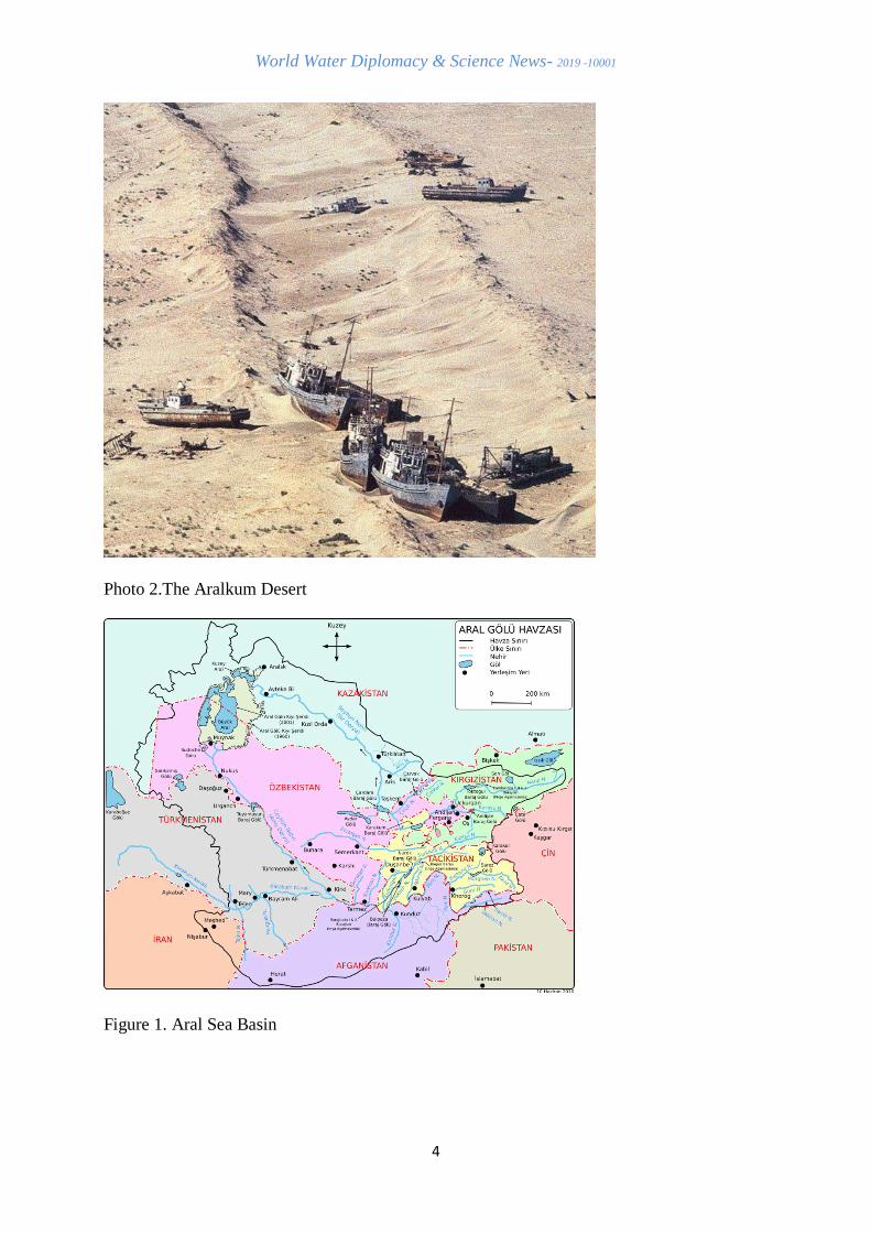
Photo 2.The Aralkum Desert
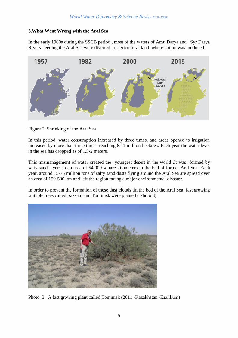
Figure 1. Aral Sea Basin
World Water Diplomacy & Science News- 2019 -10001
5
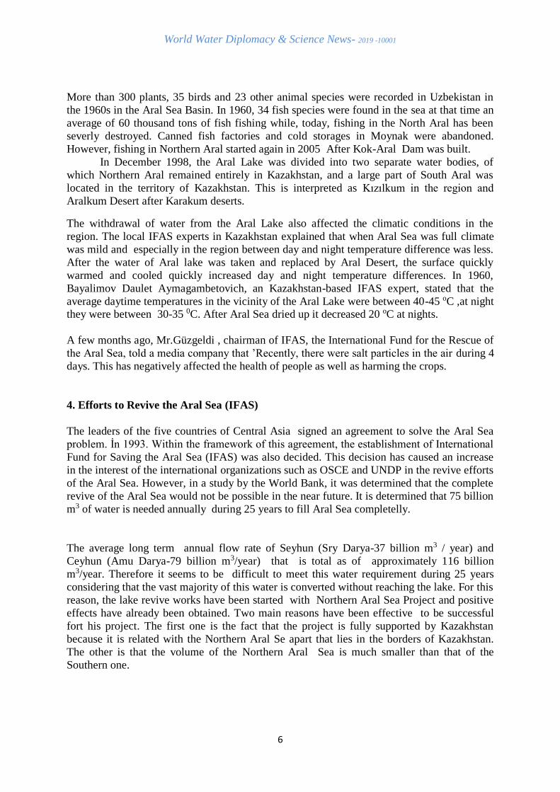
3.What Went Wrong with the Aral Sea
In the early 1960s during the SSCB period , most of the waters of Amu Darya and Syr Darya
Rivers feeding the Aral Sea were diverted to agricultural land where cotton was produced.
Figure 2. Shrinking of the Aral Sea
In this period, water consumption increased by three times, and areas opened to irrigation
increased by more than three times, reaching 8.11 million hectares. Each year the water level
in the sea has dropped as of 1,5-2 meters.
This mismanagement of water created the youngest desert in the world .It was formed by
salty sand layers in an area of 54,000 square kilometers in the bed of former Aral Sea .Each
year, around 15-75 million tons of salty sand dusts flying around the Aral Sea are spread over
an area of 150-500 km and left the region facing a major environmental disaster.
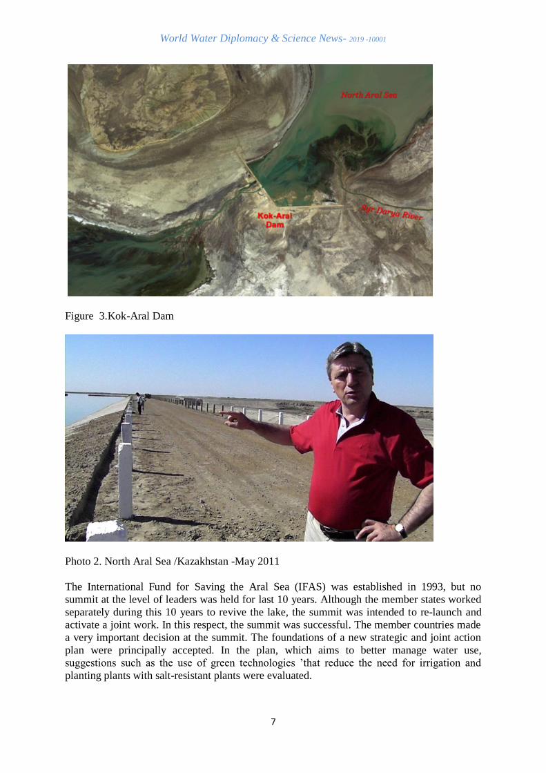
In order to prevent the formation of these dust clouds ,in the bed of the Aral Sea fast growing
suitable trees called Saksaul and Tominisk were planted ( Photo 3).
Photo 3. A fast growing plant called Tominisk (2011 -Kazakhstan -Kızılkum)
World Water Diplomacy & Science News- 2019 -10001
6
More than 300 plants, 35 birds and 23 other animal species were recorded in Uzbekistan in
the 1960s in the Aral Sea Basin. In 1960, 34 fish species were found in the sea at that time an
average of 60 thousand tons of fish fishing while, today, fishing in the North Aral has been
severly destroyed. Canned fish factories and cold storages in Moynak were abandoned.
However, fishing in Northern Aral started again in 2005 After Kok-Aral Dam was built.
In December 1998, the Aral Lake was divided into two separate water bodies, of
which Northern Aral remained entirely in Kazakhstan, and a large part of South Aral was
located in the territory of Kazakhstan. This is interpreted as Kızılkum in the region and
Aralkum Desert after Karakum deserts.
The withdrawal of water from the Aral Lake also affected the climatic conditions in the
region. The local IFAS experts in Kazakhstan explained that when Aral Sea was full climate
was mild and especially in the region between day and night temperature difference was less.
After the water of Aral lake was taken and replaced by Aral Desert, the surface quickly
warmed and cooled quickly increased day and night temperature differences. In 1960,
Bayalimov Daulet Aymagambetovich, an Kazakhstan-based IFAS expert, stated that the
average daytime temperatures in the vicinity of the Aral Lake were between 40-45 oC ,at night they were between 30-35 0C. After Aral Sea dried up it decreased 20 oC at nights.
A few months ago, Mr.Güzgeldi , chairman of IFAS, the International Fund for the Rescue of
the Aral Sea, told a media company that ’Recently, there were salt particles in the air during 4
days. This has negatively affected the health of people as well as harming the crops.
4. Efforts to Revive the Aral Sea (IFAS)
The leaders of the five countries of Central Asia signed an agreement to solve the Aral Sea
problem. İn 1993. Within the framework of this agreement, the establishment of International
Fund for Saving the Aral Sea (IFAS) was also decided. This decision has caused an increase
in the interest of the international organizations such as OSCE and UNDP in the revive efforts
of the Aral Sea. However, in a study by the World Bank, it was determined that the complete
revive of the Aral Sea would not be possible in the near future. It is determined that 75 billion
m3 of water is needed annually during 25 years to fill Aral Sea completelly.
The average long term annual flow rate of Seyhun (Sry Darya-37 billion m3 / year) and
Ceyhun (Amu Darya-79 billion m3/year) that is total as of approximately 116 billion
m3/year. Therefore it seems to be difficult to meet this water requirement during 25 years
considering that the vast majority of this water is converted without reaching the lake. For this
reason, the lake revive works have been started with Northern Aral Sea Project and positive
effects have already been obtained. Two main reasons have been effective to be successful
fort his project. The first one is the fact that the project is fully supported by Kazakhstan
because it is related with the Northern Aral Se apart that lies in the borders of Kazakhstan.
The other is that the volume of the Northern Aral Sea is much smaller than that of the
Southern one.
World Water Diplomacy & Science News- 2019 -10001
7
Figure 3.Kok-Aral Dam
Photo 2. North Aral Sea /Kazakhstan -May 2011
The International Fund for Saving the Aral Sea (IFAS) was established in 1993, but no
summit at the level of leaders was held for last 10 years. Although the member states worked
separately during this 10 years to revive the lake, the summit was intended to re-launch and
activate a joint work. In this respect, the summit was successful. The member countries made
a very important decision at the summit. The foundations of a new strategic and joint action
plan were principally accepted. In the plan, which aims to better manage water use,
suggestions such as the use of green technologies ’that reduce the need for irrigation and
planting plants with salt-resistant plants were evaluated.
World Water Diplomacy & Science News- 2019 -10001
8
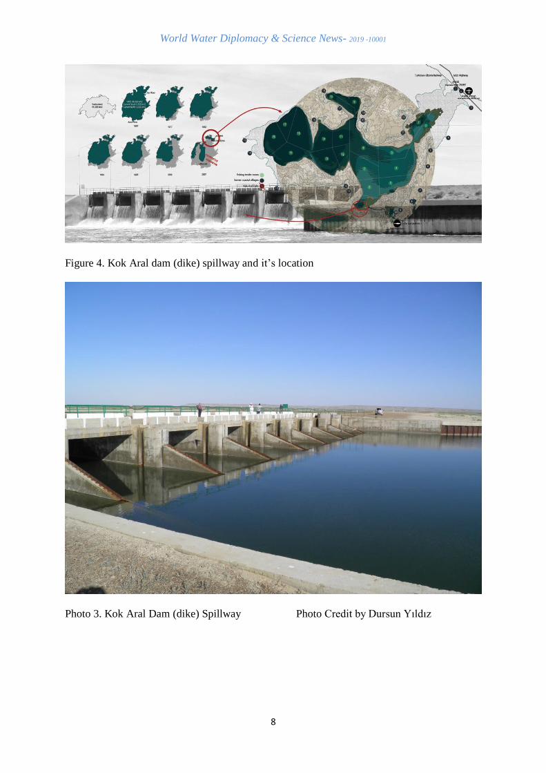
Figure 4. Kok Aral dam (dike) spillway and it’s location
Photo 3. Kok Aral Dam (dike) Spillway Photo Credit by Dursun Yıldız
World Water Diplomacy & Science News- 2019 -10001
9
5. Partial Restoration of the Small (Northern) Aral Sea
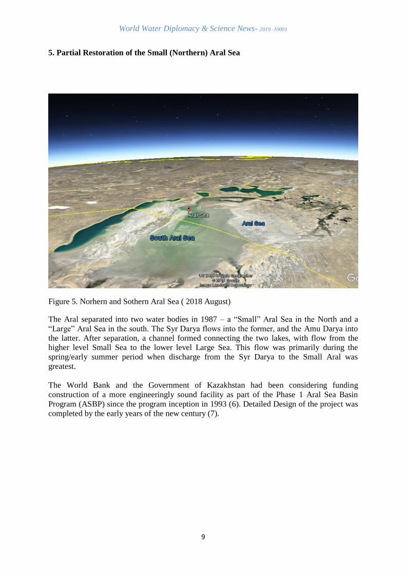
Figure 5. Norhern and Sothern Aral Sea ( 2018 August)
The Aral separated into two water bodies in 1987 – a “Small” Aral Sea in the North and a
“Large” Aral Sea in the south. The Syr Darya flows into the former, and the Amu Darya into
the latter. After separation, a channel formed connecting the two lakes, with flow from the higher level Small Sea to the lower level Large Sea. This flow was primarily during the
spring/early summer period when discharge from the Syr Darya to the Small Aral was
greatest.
The World Bank and the Government of Kazakhstan had been considering funding
construction of a more engineeringly sound facility as part of the Phase 1 Aral Sea Basin
Program (ASBP) since the program inception in 1993 (6). Detailed Design of the project was
completed by the early years of the new century (7).
World Water Diplomacy & Science News- 2019 -10001
10
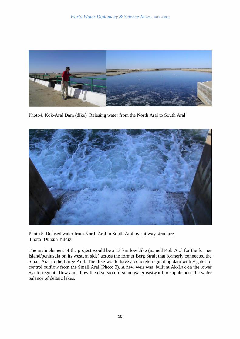
Photo4. Kok-Aral Dam (dike) Relesing water from the North Aral to South Aral
Photo 5. Relased water from North Aral to South Aral by spilway structure
Photo: Dursun Yıldız
The main element of the project would be a 13-km low dike (named Kok-Aral for the former
Island/peninsula on its western side) across the former Berg Strait that formerly connected the
Small Aral to the Large Aral. The dike would have a concrete regulating dam with 9 gates to
control outflow from the Small Aral (Photo 3). A new weir was built at Ak-Lak on the lower
Syr to regulate flow and allow the diversion of some water eastward to supplement the water
balance of deltaic lakes.
World Water Diplomacy & Science News- 2019 -10001
11
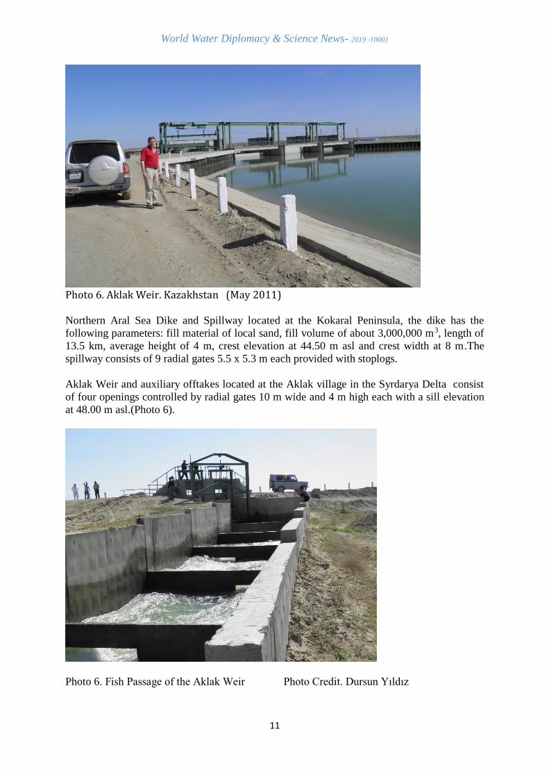
Photo 6. Aklak Weir. Kazakhstan (May 2011)
Northern Aral Sea Dike and Spillway located at the Kokaral Peninsula, the dike has the
following parameters: fill material of local sand, fill volume of about 3,000,000 m3, length of
13.5 km, average height of 4 m, crest elevation at 44.50 m asl and crest width at 8 m.The
spillway consists of 9 radial gates 5.5 x 5.3 m each provided with stoplogs.
Aklak Weir and auxiliary offtakes located at the Aklak village in the Syrdarya Delta consist
of four openings controlled by radial gates 10 m wide and 4 m high each with a sill elevation
at 48.00 m asl.(Photo 6).
Photo 6. Fish Passage of the Aklak Weir Photo Credit. Dursun Yıldız
World Water Diplomacy & Science News- 2019 -10001
12
The maximum expected runoff of the Syrdarya at the site is 515 m3/s in summer and 395 m3/s
in winter. The auxiliary structures consist of eight gated offtakes to be rehabilitated and/or
reconstructed with capacities between 1 and 10 m3/s upstream of the weir, which supply water
for fishing lakes and irrigation of hayfields in the Syrdarya Delta. The weir has a fish pass of
a slot type (Photo 6) . The works completed within three years.
Improvements were also to be made to the bed of the Syr Darya down stream of the
Chardarya Dam to enhance water flow to the sea. Cost of the entire project was set at 86
million USD with the World Bank providing 65 million and the Kazakhstan government 21
million. Construction work began in 2003 and the dike-dam were completed by August 2005
(7).
After the completion of Kok-Aral Water storage structure in 2005, the water level in the lake
was 38 m. This dam (dike) caused the lake area to increase by 874 km2 to 3288 km2 and the
volume of water in the lake increased by 11.5 billion m3 to 27 billion m3 and the salinity
amount decreased from 23 g / lt to 17 g / lt. its salinity decreased substantially reaching an
average of about 8 g/l by September 2011, leading to greatly improved ecological conditions
and a revitalized fishery. This situation allowed to catch 8000 tons of fish a year and export it
to Russia and Eastern Europe (Figure 4).
The level of the Small (northern) Aral has been stabilized by this dike at 42 m above sea level
that is still 11.4 m below its 1960’s level(3).
How to Bring It Back ?
What about bringing the Aral Sea back to its pre-drying up conditions, characteristic of the
first 60 years of the twentieth century with a level near 53 m, area of the water surface about
66,100 km2, volume around 1,064 km3 and average salinity from 9.3 to 10.3 g/l (4)? This
would be ideal, but is it realistic? Such rejuvenation would require average annual aggregate
inflow from the Amu + Syr rivers of 56 km3, assuming surface net evaporation of 869 mm
(evaporation of 993 mm minus precipitation of 124 mm derived from data published in
reference 4 ) and estimated net groundwater inflow of 2.5 km3.According to an Excel based
annually iterated fill model devised by the author that assumes a trapezoidal cross section for
the portion of the sea to be restored, refilling would require about 103 years given its area and
volume in September 2011 (5).
The restoration would follow a logistics curve: rapid at first as inflow greatly exceeded net
evaporation, then slowing and approaching zero as net evaporation grew and approached total
inflow fromthe rivers Amu Darya and Syr Darya plus net groundwater influx. However, the
sea would reach 50 m (94 % of stability level) and have an area of 60,000km2 (91% of
stability area) and volume over 800 km3 (75 % of stability volume) in just 43 years (3).
The restoration time also depens on the climate change effects in the region . If surface
evaporation rose by 11 %, likely a conservative assumption, with other water balance
parameters remaining the same, it would take 63 km3/year and 97 years to refill the sea its
pre-1960s conditions. The level of 50 m, area of 60,000 km2 and volume of 800 km3 would
be reached in 40 years. But the recent flows to the Aral have been far below 56 km3, let alone
62–63 km3. The author(3) estimates the average annual inflow to the sea from 2000 through
2011 at 8.8 km3 (6.6 km3 from the Syr and 2.2 km3 from the Amu, including direct irrigation.
World Water Diplomacy & Science News- 2019 -10001
13
In his study ,Micklin stated that “It is doubtful the Aral could be restored to its former
grandeur in the foreseeable future(3). The amount of water that would need to be saved is far
above even the most optimistic and costly scenario of water use efficiency improvements. For
example, assuming net water savings in irrigation of 20 km3/year could be reached, there still
would be a deficit of 27 km3, assuming average future inflow of 8.8 km3 that was experienced
from 2000 through 2011”
6.Results and Evaluations
What will all these efforts bring for the future of the Aral Sea ? It will bring a potential
positive environmental impacts in and around the Northern Aral Sea and the Syrdarya delta
would include:
(i) the creation of a freshwater reservoir;
(ii) the filling of lagoons and delta lakes;
(iii) an increase in wetlands;
(iv) a reduction in salt and dust storms;
(v) the restoration if biological diversity; and
(vi) an improved ecological system.
The actual impact would depend on the design water level in the Northern Aral Sea .The
progress in the Northern Aral has increased hopes for the return of the Aral Sea. However, the
complete return of the Sea will not be as easy as the Northern Aral Part .It is clear that
engineering structures and facilities provided by the geography have helped to solve the
problem in this part. However, the solution for South Aral is more dependent on water
management and hydro-political relations among the riparian state .
The alternative of carrying water from the other basin to the Aral Sea may not be a sustainable
solution. Therefore, instead of bringing water out of the basin, the solution should be searched
primarily within the basin. This makes it possible to link the return of the Aral Sea with the
more efficient use of water in the basin countries. The water resources in the Aral Basin are
threatened by the inefficient use of water as well as the climate change effects.
If one ask that will the Aral Sea come back? In fact ,it is difficult to give a favorable response
this question for a near future. Therefore, we assume that the lake, which was lost in half a
century as a whole, will be able to come back in a longer period and it will occur part by part.
The annual average water of the Ceyhun River pouring into the Southern Aral Sea is
approximately twice that of Seyhun, which is still pouring into the Northern Aral . However,
this water is used in a very inefficient way to reach the lake. It seems to be difficult to fill a
lake volume about 10 times larger than the North Aral.
As a result, there are many problems to the return of South Aral Sea, ranging from the
inefficient use of water in the basin, the negative consequences of global climate change and
the geopolitical obstacles to the softening of hydro-political relations among riparian state.
I regret to say that the Aral Sea will also be given by next generation as a live example of an
environmental disaster created by the water mismanagement.
Referanslar
World Water Diplomacy & Science News- 2019 -10001
14
1-Yıldız D. 2011 Orta Asya'nın Stratejik Suları. Truva Yayınları.İstanbul (in Turkish)
2-Yıldız D. 2011 Orta Asya'nın Saatli Bombası: Su Sorunu. Truva Yayınları. İstanbul (in
Turkish)
3-Micklin P 2014 “Efforts to Revive the Aral Sea” P. Micklin et al. (eds.), The Aral Sea,
Springer Earth System Sciences, DOI 10.1007/978-3-642-02356-9_15, © Springer-Verlag
Berlin Heidelberg 2014 Referanslar
4- Bortnik VN, Chistyaevaya SP (eds) (1990) Hydrometeorology and hydrochemistry of the
Seas of the USSR, vol VII, Aral Sea. Gidrometeoizdat, Leningrad (in Russian)
5- Micklin P (2012a) Annualized excel spreadsheet fill model with input parameters of initial
sea volume (km3), area (km2) and initial and final level (meters), average river inflow (km3),
average groundwater inflow (km3), average net evaporation (E-P) in millimeters and a
measure of the increase in area for each meter rise of the sea in (km2/m) derived from the
slope of the sides of the trapezoid
6-Aral Sea Program (1994) Phase 1 aide memoire, World Bank Preparation Mission, March
1994. Europe and Central Asia Region, Country Department 3, Country Operations Division
I, Washington, DC, pp 43–45
7-Expedition (2005) Unpublished observations, information, and data gathered during an
expedition to the Aral Sea led by Philip Micklin and Nikolay Aladin, Aug 22–Sept 23.
Funded by the Committee on Research and Exploration, National Geographic Society, Grant
7825–05
Biography
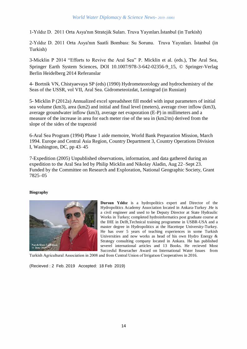
Dursun Yıldız is a hydropolitics expert and Director of the
Hydropolitics Academy Association located in Ankara-Turkey .He is
a civil engineer and used to be Deputy Director at State Hydraulic
Works in Turkey; completed hydroinformatics post graduate course at
the IHE in Delft,Technical training programme in USBR-USA and a
master degree in Hydropolitics at the Hacettepe University-Turkey.
He has over 5 years of teaching experiences in some Turkish
Universities and now works as head of his own Hydro Energy &
Strategy consulting company located in Ankara. He has published
severel international articles and 13 Books. He recieved Most
Succesful Reseracher Award on International Water Issues from
Turkish Agricultural Association in 2008 and from Central Union of Irrigatıon Cooperatives in 2016.
(Recieved : 2 Feb. 2019 Accepted: 18 Feb 2019)