Embed Size (px)
Citation preview

WXXM-1OJN 5/14/09
MIT Lincoln Laboratory
WXXM, JMBL, CAP Discussion
NNEW Data Format Meeting
17 November, 2009

MIT Lincoln LaboratoryWXXM-2
OJN 5/14/09
WXXM and the AIM Data Model Family
Source: Sam Van Der Stricht, “Digital AIM Evolution” Singapore Global AIM Congress, 2008
* Eurocontrol issued WXXM 1.0.1 release in mid-2008* Eurocontrol issued WXXM 1.0.1 release in mid-2008
*

MIT Lincoln LaboratoryWXXM-3
OJN 5/14/09
Common Weather Data Types

MIT Lincoln LaboratoryWXXM-4
OJN 5/14/09
General High-Level WXXM Goals
• Represent wide variety of weather data types
• Standards-based, ISO/OGC foundation– Increases interoperability with other AIM data models
• Modular
• Extensible
• Versionable
XML
. . . . .
ISO 19139
GML
AIXM 5.0 WXXM 1.0

MIT Lincoln LaboratoryWXXM-5
OJN 5/14/09
Goals for WXXM 1.1
• Partition schema (WXXS) into general weather concepts and aviation-specific weather concepts
– Motivation: Allow users to incorporate only the concepts they need (general schema best practice)
• Align with U.K. Climate Science Modeling Language (CSML) and NetCDF Common Data Model (CDM) general weather data types
• Support the ability to use NetCDF Climate and Forecast (CF) standard names and JMBL parameter names within WXXM.
• Refactor/simplify observation/forecast data type hierarchy
• Refine time semantics– Motivation: Forecast time semantics in WXXM 1.0
constrained by underlying O&M model
• Evaluate standards-based units of measure (applies to WXXM and AIXM)
• Enhance support for Ontologies

MIT Lincoln LaboratoryWXXM-6
OJN 5/14/09
Composable Weather Data Model v1.1
XML
ISO 19139
Observations & Measurements
General-purpose WXXM Components
GML
Observations & Measurements / ISO 19123
General-purpose Weather Components
Aviation-Specific Weather Components
Eurocontrol-SpecificComponents
FAA-SpecificComponents
Composable, extensible data model balances standardization with the need for individual communities (FAA, Eurocontrol, DOD, NWS) to innovateComposable, extensible data model balances standardization with the need for individual communities (FAA, Eurocontrol, DOD, NWS) to innovate
DOD-SpecificComponents
W3C
ISO / OGC
World MeteorologicalOrganization (WMO)(envisioned)
International CivilAviation Organization (ICAO)(envisioned)
Individual Organizations
Standards Governance BodyData Model
Component Agility
High(months)
Low(years)
NWS-SpecificComponents

MIT Lincoln LaboratoryWXXM-7
OJN 5/14/09
Data Type Alignment
• WXXM consists of a set of general types (grid) as well as more specialized types (METAR)
• The specialized types are often built on top of the more general types
• What are the most appropriate general types?
• Look to the weather community for existing relevant work…– Climate Science Modeling Language (CSML)– NetCDF Common Data Model (CDM)– JMBL
• Key question: Prefer strong or weak typing for general types?

MIT Lincoln LaboratoryWXXM-8
OJN 5/14/09
Strong vs. Weak Typing
Weak-typing example. Schema has relatively few elements and can represent multiple types of measurements. External vocabularies required. (JMBL)
Weak-typing example. Schema has relatively few elements and can represent multiple types of measurements. External vocabularies required. (JMBL)
Strong-typing example. Schema fully defines a particular data type. One type required for each measurement type. External vocabularies not required. (WXXM 1.0 focus)
Strong-typing example. Schema fully defines a particular data type. One type required for each measurement type. External vocabularies not required. (WXXM 1.0 focus)

MIT Lincoln LaboratoryWXXM-9
OJN 5/14/09
WXXM/CSML/NetCDF Data TypeAlignment:Strong vs. Weak Typing
• CSML User's Guide: – “A-priori, it is not always obvious to a designer of feature
types how strongly typed they should be. In general, the more specialised the feature types, the greater will be the number required to capture the spectrum of information types used by the community.”
• Strong types = Build-time implementation– Schema -> Schema Compiler -> Java Objects -> Application
• Build-time behavior inherently more heavyweight w/respect to change
• If additional strong types add primarily type information, and not addtional attributes/behaviour, consider substituting weak types in name of agility.
• CSML Key Concept: Support typical weather sampling geometries, and allow flexibility with what type of weather product is sampled within that geometry (soft-typing)
• Well-aligned with NetCDF Common Data Model approach• Supports large number of data types
• CSML Key Concept: Support typical weather sampling geometries, and allow flexibility with what type of weather product is sampled within that geometry (soft-typing)
• Well-aligned with NetCDF Common Data Model approach• Supports large number of data types

MIT Lincoln LaboratoryWXXM-10
OJN 5/14/09
CSML Version 2 Feature Types
Feature type Description Example
PointFeature Single point measurement. raingauge measurement
PointSeriesFeature Time-series of single datum measurements at a fixed location in space.
tidegauge, rainfall timeseries
TrajectoryFeature Measurement along a discrete path in time and space.
surface salinity along a ship’s cruise track; atmospheric aerosols along an aircraft’s flight path
PointCollectionFeature Collection of distributed single datum measurements at a particular time
2m temperatures measured at weather stations across the UK at 0600z.
ProfileFeature Single ‘profile’ of some parameter along a vertical line in space.
wind sounding, XBT, CTD, radiosonde
ProfileSeriesFeature Time-series of profiles on fixed vertical levels at a fixed location
vertical radar timeseries, thermistor chain timeseries
RaggedProfileSeriesFeature
Time-series of unequal-length profiles, but on fixed vertical levels, at a fixed location
repeat daily balloon soundings of atmospheric temperature from the same location
SectionFeature Series of profiles from positions along a trajectory in time and space.
shipborne ADCP
RaggedSectionFeature Series of profiles of unequal length along a trajectory in time and space
marine CTD measurements along a ship’s cruise track
ScanningRadarFeature Backscatter profiles along a look direction at fixed elevation but rotating in azimuth
weather radar
GridFeature Single time-snapshot of a gridded field.
gridded analysis field
GridSeriesFeature Time-series of gridded parameter fields
numerical weather prediction model, ocean general circulation model
SwathFeature Two-dimensional grid of data along a satellite ground-path
AVHRR satellite imagery

MIT Lincoln LaboratoryWXXM-11
OJN 5/14/09
Data ModelOperational and Knowledge Domains
OWL
Wordnet (in OWL form) / SUMO
Observations & Measurements
General-purpose WXXM Components
JPL SWEET
Weather/Oceanography Ontology
CF Standard Name Ontology, JMBL Parameter Ontology
Aviation-specific Ontology
Eurocontrol Weather Ontology Ext FAA Weather Ontology Ext
XML
ISO 19139
Observations & Measurements
General-purpose WXXM Components
GML
Observations & Measurements / ISO 19123
General-purpose WXXM/CSML Components
Aviation-specific WXXM Components (Annex 3 + ?)
Eurocontrol WXXM Ext FAA WXXM Ext
Operational Domain (XML Application Schema)
Knowledge Domain(OWL)
Rapidly Changing Information(Measurements)
Relatively Static Information(Types, Associations, Classifcations)
Notional Only - Intent is to delineate the two domains and illustrate the layered structure of each. Layers at same relative level in each domain
do not necessary map to each other
Notional Only - Intent is to delineate the two domains and illustrate the layered structure of each. Layers at same relative level in each domain
do not necessary map to each other
Link to concepts inknowledge domain

MIT Lincoln LaboratoryWXXM-12
OJN 5/14/09
NextGen Weather Ontology – Wind
LegendSWEET 2.0
JMBL derived
Weather Ontology
WordNet derived
Ontologies wind.owl & precipitation.owl with more complete set of concepts availableOntologies wind.owl & precipitation.owl with more complete set of concepts available
MIT Lincoln LaboratoryWXXM-13
OJN 5/14/09
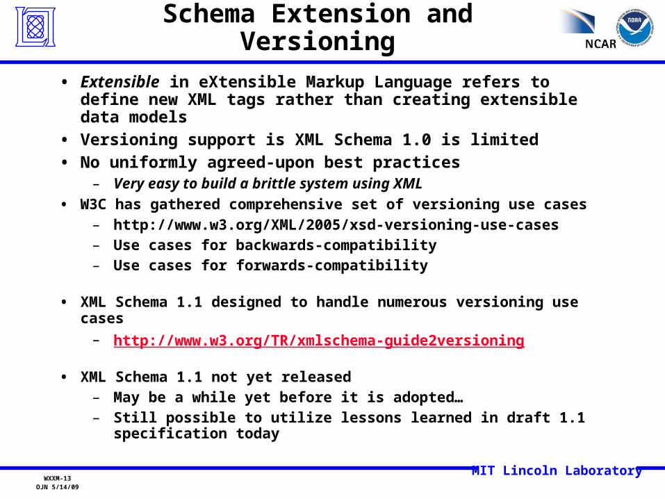
Schema Extension and Versioning
• Extensible in eXtensible Markup Language refers to define new XML tags rather than creating extensible data models
• Versioning support is XML Schema 1.0 is limited
• No uniformly agreed-upon best practices– Very easy to build a brittle system using XML
• W3C has gathered comprehensive set of versioning use cases– http://www.w3.org/XML/2005/xsd-versioning-use-cases– Use cases for backwards-compatibility– Use cases for forwards-compatibility
• XML Schema 1.1 designed to handle numerous versioning use cases
– http://www.w3.org/TR/xmlschema-guide2versioning
• XML Schema 1.1 not yet released– May be a while yet before it is adopted…– Still possible to utilize lessons learned in draft 1.1 specification
today

MIT Lincoln LaboratoryWXXM-14
OJN 5/14/09
Extending XML Schemas - Options
• Use XmlSchema #any element definitions in strategic spots within Domain-specific types
– Prevents type derivation from those types in some situations
• Incorporate <ext> </ext> block(s) into domain-specific types, and let them contain any element type
– Labor intensive, additions are 2nd-class citizens in some respects
• Open content model– Extensions typically added in their own namespace– No limitation on where elements are added– Use rules-based validation in place of XmlSchema 1.0
validation if consumer-side validation is required. (Schematron)
– XmlSchema 1.1 adding explicit support for open content models

MIT Lincoln LaboratoryWXXM-15
OJN 5/14/09
XML Schema 1.1Open Content Model Support
<xs:schema xmlns:xs="http://www.w3.org/2001/XMLSchema" targetNamespace="http://www.example.org/ns/personName/1.0" elementFormDefault="qualified">
<xs:openContent mode="interleave"> <xs:any namespace="##any" processContents="lax" minOccurs="0" maxOccurs="unbounded"/> </xs:openContent>
<xs:complexType name="nameType"> <xs:sequence> <xs:element name="given" type="xs:string"/> <xs:element name="family" type="xs:string"/> </xs:sequence> <xs:anyAttribute/> </xs:complexType>
<xs:element name="personName" type="namens:nameType"/></xs:schema
Global declaration of open content modelwill allow insertion of additional elements
(e.g., 'middleName' )
over time, while still supporting XmlSchema-basedvalidation
Global declaration of open content modelwill allow insertion of additional elements
(e.g., 'middleName' )
over time, while still supporting XmlSchema-basedvalidation
• While emerging support for versioning using XmlSchema 1.1 validation is a good thing, it is not yet released, and software infrastructure support will not be immediate when it is released (2009?)
• As with general extension case, use alternate means of validation where necessary (e.g., Schematron or other rules-based validation)

MIT Lincoln LaboratoryWXXM-16
OJN 5/14/09
Core METAR Observation
<an3:METAR xmlns:an3="http://www.icao.int/annex3/1.0" xmlns:wx="http://www.eurocontrol.int/wxxs/1.0" xmlns:om="http://www.opengis.net/om/1.0/gml32" xmlns:swe="http://www.opengis.net/swe/1.0/gml32" xmlns:gml="http://www.opengis.net/gml/3.2" xmlns:xsi="http://www.w3.org/2001/XMLSchema-instance">
<rawText>METAR KTTN 051853Z 04011KT 1/2SM VCTS SN ...</rawText> <type>METAR</type> <observationTime>2008-11-04T14:46:21.735-05:00</observationTime> <automatedOrMissing>false</automatedOrMissing> <cavok>true</cavok>
<observation> <wx:AerodromeAreaWeatherObservation>
<om:observedProperty> <swe:Phenomenon> <gml:identifier>http://noaa.gov/ontology/wx.owl#airTemperature</gml:identifier> </swe:Phenomenon> </om:observedProperty>
<om:featureOfInterest> <wx:AerodromeArea> <qfe>20.0</qfe> </wx:AerodromeArea> </om:featureOfInterest>
<om:result uom="C" xsi:type="gml:MeasureType"">10.0</om:result> </wx:AerodromeAreaWeatherObservation> </observation>
</an3:METAR>
Namespaces for individual schemacomponents

MIT Lincoln LaboratoryWXXM-17
OJN 5/14/09
Notional FAA-Extended METAR Observation
<an3:METAR xsi:type=”faa-an3:ExtendedMETARType” xmlns:faa-an3=”http://faa.gov/annex3-ext/1.0” xmlns:an3="http://www.icao.int/annex3/1.0" xmlns:wx="http://www.eurocontrol.int/wxxs/1.0" xmlns:om="http://www.opengis.net/om/1.0/gml32" xmlns:swe="http://www.opengis.net/swe/1.0/gml32" xmlns:gml="http://www.opengis.net/gml/3.2" xmlns:xsi="http://www.w3.org/2001/XMLSchema-instance">
<rawText>METAR KTTN 051853Z 04011KT 1/2SM VCTS SN ...</rawText> <type>METAR</type> <observationTime>2008-11-04T14:46:21.735-05:00</observationTime> <automatedOrMissing>false</automatedOrMissing> <cavok>true</cavok>
<faa-an3:starbucksAtAerodrome>true</faa-an3:starbucksAtAerodrome>
<observation> <wx:AerodromeAreaWeatherObservation>
<om:observedProperty> <swe:Phenomenon> <gml:identifier>http://noaa.gov/ontology/wx.owl#airTemperature</gml:identifier> </swe:Phenomenon> </om:observedProperty>
<om:featureOfInterest> <wx:AerodromeArea> <qfe>20.0</qfe> </wx:AerodromeArea> </om:featureOfInterest>
<om:result uom="C" xsi:type="gml:MeasureType"">10.0</om:result> </wx:AerodromeAreaWeatherObservation> </observation>
</an3:METAR>
• Extensions added in separate namespace• Can be ignored by consumers that do not support the
extended namespace• Base <an3:METAR> element name used for extended
type. This preserves the ability of consumers that support the base class to process the base class data elements
• Assumes use of open content model on consumer side
• No extension points required in core schema

MIT Lincoln LaboratoryWXXM-18
OJN 5/14/09
Namespace-based versioning
• Use major/minor numbering schema– Minor number change implies a backwards/forwards
compatible change– Major number change implies a change that breaks
backwards and/or forwards compatibility
• Use open-content model and ignore-unknowns parsing policy– New XML elements in minor releases are ignored by older
consumers
• Any new elements must be optional to preserve forwards compatibility
– Allows new consumers to parse data from older producers– Balance between too many optional elements and
interoperability. When threshold reached, move to next major version. (a bit of an art to determine when that is)
• Today's tooling can support this versioning approach– Parsers support ignore-unknowns policy when XmlSchema
1.0 validation is turned off

MIT Lincoln LaboratoryWXXM-19
OJN 5/14/09
Common Alerting ProtocolThunderstorm Warning Example
<?xml version = "1.0" encoding = "UTF-8"?> <alert xmlns = "urn:oasis:names:tc:emergency:cap:1.1"> <identifier>KSTO1055887203</identifier> <sender>[email protected]</sender>
<sent>2003-06-17T14:57:00-07:00</sent> <status>Actual</status> <msgType>Alert</msgType><scope>Public</scope><info>
<category>Met</category> <event>SEVERE THUNDERSTORM</event> <responseType>Shelter</responseType> <urgency>Immediate</urgency> <severity>Severe</severity> <certainty>Observed</certainty> <eventCode>
<valueName>same</valueName> <value>SVR</value>
</eventCode>
<effective>2003-06-17T15:00:00-07:00</effective> <expires>2003-06-17T16:00:00-07:00</expires>
<senderName>NATIONAL WEATHER SERVICE SACRAMENTO CA</senderName> <headline>SEVERE THUNDERSTORM WARNING</headline>
<description> AT 254 PM PDT...NATIONAL WEATHER SERVICE DOPPLER RADAR INDICATED A SEVERE 509 THUNDERSTORM OVER SOUTH CENTRAL ALPINE COUNTY...OR ABOUT 18 MILES SOUTHEAST OF KIRKWOOD...MOVING 510 SOUTHWEST AT 5 MPH. HAIL...INTENSE RAIN AND STRONG DAMAGING WINDS ARE LIKELY WITH THIS 511 STORM.</description>
<instruction>TAKE COVER IN A SUBSTANTIAL SHELTER UNTIL THE STORM PASSES.</instruction> <contact>BARUFFALDI/JUSKIE</contact>
<area><areaDesc>EXTREME NORTH CENTRAL TUOLUMNE COUNTY IN CALIFORNIA, EXTREME NORTHEASTERN 516 CALAVERAS
COUNTY IN CALIFORNIA, SOUTHWESTERN ALPINE COUNTY IN CALIFORNIA</areaDesc><polygon>38.47,-120.14 38.34,-119.95 38.52,-119.74 38.62,-119.89 38.47,-120.14</polygon><geocode>
<valueName>FIPS6</valueName><value>006109</value>
</geocode></area>
</info></alert>
NNEW Guidance: Use URN for identifier (urn:fdc:nws.noaa.gov:Alert:KSTO105587203)
Use term from Weather Ontology (enables more flexible filtering, discovery)
WFS RI needs to be CAP-Aware for When, Where metadata


![Small scale concentrating solar energy system with heat ...folk.ntnu.no/ojn/Solar/Files/SolarFinalReport[13].pdf · Network Projects: Small scale concentrating solar energy system](https://img.pdfslide.net/doc/110x75/5e78ebb9d131d155581a5f9c/small-scale-concentrating-solar-energy-system-with-heat-folkntnunoojnsolarfilessolarfinalreport13pdf.jpg)