Embed Size (px)
Citation preview

60°N
30°N
0°
60°S
30°S
90°E
90°S 90°S
0°
90°E
30°N
60°E120°E 150°E 180°W 0°
60°S
90°W
30°S
30°W60°W120°W 30°E
60°N
150°W 90°N90°N
E q u a t o r Pr
ime
M
er
idia
nIn
ter
na
tio
na
l D
at
e
Lin
e (
ap
pr
ox
i ma
t e)
45°N
41°N
104°W111°W
41°N
45°N
111°W 104°W
UTAH
MONTANA
IDAHO
COLORADO
WYOMING
NEBRASKA
SOUTH DAKOTA
Wyoming and the world 7
The state of Wyoming is located in the central part of the North American continent, bounded between 104 and 111 degrees west longitude and 41 and 45 degrees north latitude.
Wyoming straddles the Continental Divide and the Rocky Mountains, with the Great Plains to the east and the Intermountain Basin region to the west. Wyoming shares a border with six surrounding states.
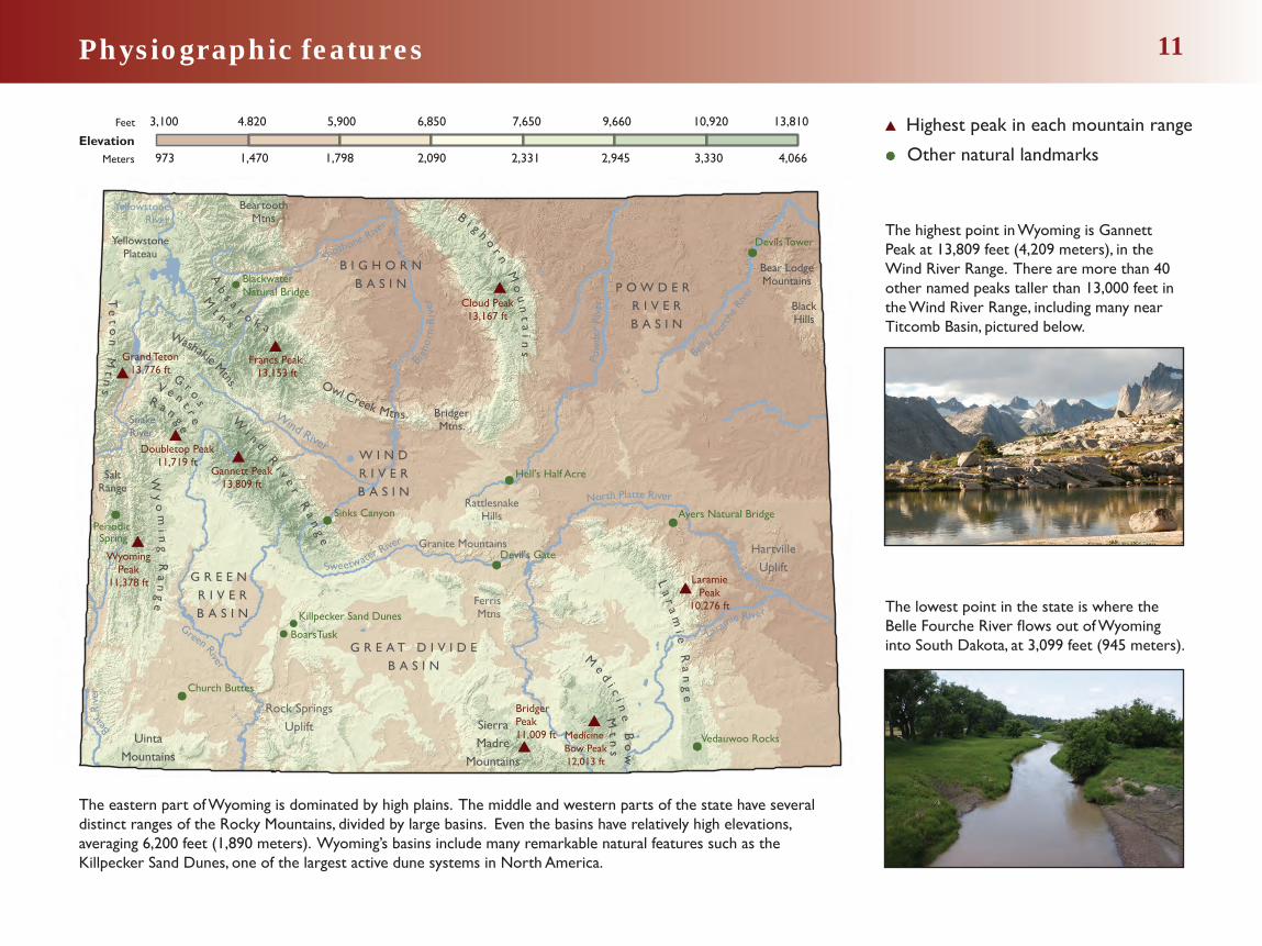
Physiographic features 11
3,100 4.820 5,900 6,850 7,650 9,660 10,920 13,810
973 1,470 1,798 2,090 2,331 2,945 3,330 4,066
Feet
Meters
Elevation
The highest point in Wyoming is Gannett Peak at 13,809 feet (4,209 meters), in the Wind River Range. There are more than 40 other named peaks taller than 13,000 feet in the Wind River Range, including many near Titcomb Basin, pictured below.
The eastern part of Wyoming is dominated by high plains. The middle and western parts of the state have several distinct ranges of the Rocky Mountains, divided by large basins. Even the basins have relatively high elevations, averaging 6,200 feet (1,890 meters). Wyoming’s basins include many remarkable natural features such as the Killpecker Sand Dunes, one of the largest active dune systems in North America.
Highest peak in each mountain range
Other natural landmarks
The lowest point in the state is where the Belle Fourche River flows out of Wyoming into South Dakota, at 3,099 feet (945 meters).
Bear
Riv
er
B i g h or n
Mo
un
ta
ins
G R E A T D I V I D EB A S I N
P O W D E R R I V E RB A S I N
G R E E N R I V E RB A S I N
W
i n d R
i v er R
an
ge
La
ra
mi e
Ra
ng
e
Wy
om
i ng
Ra
ng
e
B I G H O R NB A S I N
Cloud Peak13,167 ft
Te
to
n M
tn
s
Gannett Peak13,809 ft
Bear LodgeMountains
BlackHills
Ab
s a r o k a
Mt n s
Owl Creek Mtns. BridgerMtns.
SierraMadre
Mountains
W I N DR I V E RB A S I N
YellowstonePlateau
HartvilleUplift
RattlesnakeHills
BeartoothMtns
Washakie Mtns.
Rock SpringsUplift
UintaMountains
Green River
North Platte River
Pow
der
Rive
r
Laramie River
Belle
Four
che R
iver
Wind River
Shoshone Rive
r
SnakeRiver
YellowstoneRiver
Sweetwater River
Me d
i ci n
e B
ow
Mt
ns
G r os
V e n t r e
R a n g e
Francs Peak 13,153 ft
LaramiePeak
10,276 ft
Grand Teton13,776 ft
Bridger Peak11,009 ft
WyomingPeak
11,378 ft
Doubletop Peak11,719 ft
SaltRange
Devils Tower
Ayers Natural Bridge
Vedauwoo Rocks
Devil's Gate
Hell's Half Acre
Sinks CanyonPeriodic Spring
Church Buttes
Bigh
orn
Riv
er
BoarsTusk
Killpecker Sand Dunes
Blackwater Natural Bridge
Granite Mountains
Ferris Mtns
Medicine Bow Peak12,013 ft

Native American tribes 24
The arrival of the Spanish in the 1500s brought the domesticated horse into North America. By the 1700s, the horse became an integral part of some Native American cultures and allowed them to migrate deeper into the Great Plains, expand their hunting ranges, and to focus their hunting on bison. Before the arrival of Europeans the dominant Native American groups inhabiting Wyoming were the Shoshone, Crow, Cheyenne, and Arapaho. The Sioux Nation joined this list in the 1830s when they were invited to trade at Fort William (later Fort Laramie).
By the mid-1800s, established emigration routes like the Oregon and Bozeman trails brought increasing numbers of European Americans to settle in Wyoming. As a result, hostilities between the local tribes and settlers often escalated into open disputes where the Sioux, Cheyenne, and Arapaho defended their territories. These disputes led to a number of treaties between the Native Americans and the U.S. government to protect European settlers on what had been tribal lands.
Initially the Fort Laramie Treaty (1868) promised the Cheyenne, Crow, Arapaho, and Sioux all lands of the Powder River area and the Black Hills. The Shoshone were allotted the lands in the Wind River Valley by the Fort Bridger Treaty of 1868. By 1877, the U.S. government had seized the lands of northeastern Wyoming from the Sioux and the Crow, and relocated the Arapaho to the Wind River Reservation (1878) to live with the Shoshone, their traditional enemy.
Today, many Shoshone and Arapaho live on the Wind River Reservation in central Wyoming; the Crow and Northern Cheyenne are on reservations in southeastern Montana; and the Sioux Nation is split between reservations in South Dakota, North Dakota, and Nebraska.
Shoshone Crow Sioux Arapahoe Cheyenne
MONTANA
UTAH COLORADO
NEBRASKA
SOUTHDAKOTA
MONTNTNTNTTTTANANANANANANANANNNNAAAAAAAAAAA
UTTAAHAHHHAUTAHAHAHAH
Shoshone
Bannock
Ute
Approximate territories ofNative American tribes in 1850 Present day native lands
Crow
NNENENENEENENNNNNNEBRB ASKAAAAAAAAA
Cheyenne
COLORADO
Arapaho
SOUTHDAKOTA
Sioux
Wind RiverReservation

Percentage change 2000–2010
40.1%–73%
-2–0%
0% –7%
7.1% –17%
17.1%– 40%
Population change (2000–2010)
Population change 29
Wyoming has a population density of fewer than six people per square mile. Conversely, New Jersey, the U.S.’s most densely populated state, has 1,205 people per square mile. At that density, the entire country’s population could be packed into an area equaling the combined size of Wyoming and Montana.
Sublette and Campbell counties have both experienced rapid growth in recent years due to the presence of oil, gas and coal extraction. From 2000 to 2010, Sublette saw a 73 percent increase, while Campbell grew by 37 percent.
1910
4.3
145,965 total population
4.9
8.5
5.4
9.6
1.8 3.3
2.4
13.1
3.15.1
3.2
12.2
20.2
Numbers correspond to thousands of people
18.2
8.2
10.5
11.412
6.7
7.1
4.8
24.3
10.9
5.3
4.7
4.74.1
11.2
9.7
6.6
5.5
26.8
16.9
11.8
1930
2
2
225,565 total population
38.8
33.7
16.7
23.2
4.8
6.1
61.2
29.4
30.8
11.1
11.2
12.6
5.3
2.5
6.58.4
10.5
8.1
4.8
73.1
23.6
12.4
18.7
1990
453,588 total population
2010
43.8
40.1
15.9
28.2
8.6
75.4
10.2
46.1
36.3
13.8
21.3
18.1
7.1
2.5
7.28.5
11.7
8.7
4.8
81.7
29.1
13.2
21.1
563,626 total population
22
9
19.6
15.7
15.2
2.5
4.8
5.9
2.6 4.7
31.4
19.1
4.7
4.7
6.77.3
13.2
7.9
7.3
5.3
47.7
20.2
12.6
1950
290,529 total population
1970
18.4
28.3
13.3
17.8
3.8
5
5.9
4.8 5.6
8.6
51.3
12.9
26.4
4.5
6.35.6
10.2
6.5
4.1 56.4
2.9
17.9
10.9
332,416 total population
Population density (2010)
People per square mile
Fewer than 1
1–5
5.1–10
10.1–50
More than 50

Natural gas production
Pinedale Anticline
Jonah
Oil production
Salt Creek
Dallas Dome
Natural gas Coalbed natural gas
Total production in millions of cubic feet 1978–2013. Naturalgas is mapped by field, coalbed natural gas is mapped by section.
0–266
267–2,256
2,257–4,231
0–1.4
1.5–5.3
5.4–14.5
Gas plant
Oil and gas resources 39
Wyoming ranks fifth in the nation in the production of natural gas. Recent advancement in drilling technology may mean significant numbers of new wells in Wyoming’s Green River and Wind River basins, in addition to the large Pinedale Anticline (pictured) and Jonah fields. Coalbed natural gas production in the Powder River Basin has declined since 2009 after a decade-long boom.
The first oil well drilled in Wyoming was at Dallas Dome in 1883, followed by Salt Creek. Salt Creek is the most productive field in Wyoming’s history, producing over 696 million barrels since 1889. Wyoming’s oil boom peaked in 1970, but production has been increasing again since 2009, in part due to enhanced oil recovery. Wyoming ranks ninth in production of crude oil in the nation.
Total production in millions of barrels 1978–2013. Production is mapped by “fields,” areas which have a high density of wells.
Oil refinery
12.7–56.0
0–12.6
56.1–206.9
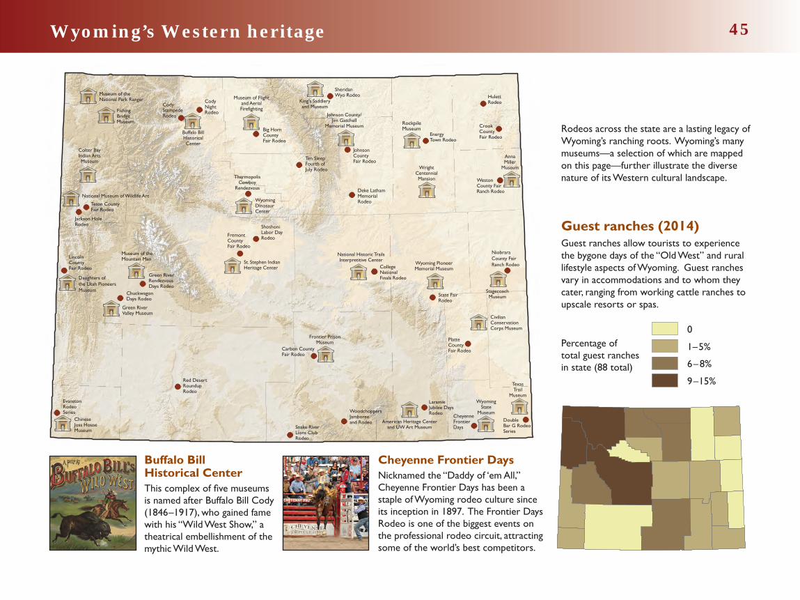
Wyoming’s Western heritage 45
Cheyenne Frontier DaysNicknamed the “Daddy of ‘em All,” Cheyenne Frontier Days has been a staple of Wyoming rodeo culture since its inception in 1897. The Frontier Days Rodeo is one of the biggest events on the professional rodeo circuit, attracting some of the world’s best competitors.
Guest ranches (2014)Guest ranches allow tourists to experience the bygone days of the “Old West” and rural lifestyle aspects of Wyoming. Guest ranches vary in accommodations and to whom they cater, ranging from working cattle ranches to upscale resorts or spas.
Buffalo Bill Historical CenterThis complex of five museums is named after Buffalo Bill Cody (1846–1917), who gained fame with his “Wild West Show,” a theatrical embellishment of the mythic Wild West.
Western-themed museums
Major recurring rodeos
Percentage of total guest ranchesin state (88 total) 6–8%
9–15%
1–5%
0
Daughters of the Utah Pioneers Museum
Johnson County/Jim Gatchell
Memorial Museum
StagecoachMuseum
Colter BayIndian ArtsMuseum
WrightCentennialMansion
WyomingState
Museum
Buffalo BillHistoricalCenter
Wyoming PioneerMemorial Museum
Museum of Flightand AerialFirefighting
CivilianConservationCorps Museum
National Historic TrailsInterpretitive Center
AnnaMiller
Museum
Museum of theMountain Man
Museum of theNational Park Ranger
St. Stephen IndianHeritage Center
RockpileMuseum
ChuckwagonDays Rodeo
JohnsonCountyFair Rodeo
CollegeNationalFinals Rodeo
CheyenneFrontierDays
CodyStampedeRodeo
CodyNightRodeo
State FairRodeo
EvanstonRodeoSeries
EnergyTown Rodeo
Deke LathamMemorialRodeo
LaramieJubilee DaysRodeo
Double Bar G RodeoSeries
Green RiverRendezvousDays Rodeo
FremontCountyFair Rodeo
SheridanWyo Rodeo
LincolnCountyFair Rodeo
PlatteCountyFair Rodeo
Big HornCountyFair Rodeo
Teton CountyFair Rodeo
NiobraraCounty FairRanch Rodeo
WestonCounty FairRanch Rodeo
CrookCountyFair Rodeo
HulettRodeo
WoodchoppersJamboreeand Rodeo
Ten SleepFourth ofJuly Rodeo
Red DesertRoundupRodeo
Snake RiverLions ClubRodeo
ThermopolisCowboy
Rendezvous
ShoshoniLabor DayRodeo
Jackson HoleRodeo
American Heritage Centerand UW Art Museum
Carbon County Fair Rodeo
National Museum of Wildlife Art
King’s Saddleryand Museum
Frontier PrisonMuseum
FishingBridgeMuseum
Chinese Joss HouseMuseum
Green RiverValley Museum
TexasTrail
Museum
WyomingDinosaurCenter
Rodeos across the state are a lasting legacy of Wyoming’s ranching roots. Wyoming’s many museums—a selection of which are mapped on this page—further illustrate the diverse nature of its Western cultural landscape.