Embed Size (px)
Citation preview
i
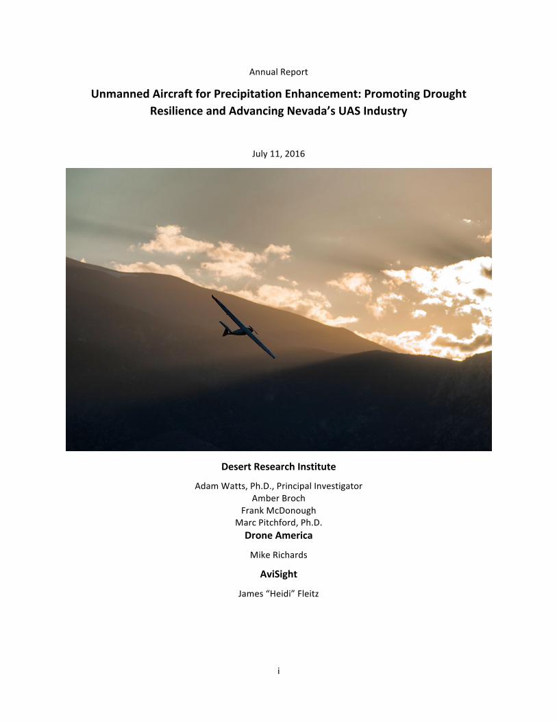
Annual Report
Unmanned Aircraft for Precipitation Enhancement: Promoting Drought Resilience and Advancing Nevada’s UAS Industry
July 11, 2016
Desert Research Institute
Adam Watts, Ph.D., Principal Investigator Amber Broch
Frank McDonough Marc Pitchford, Ph.D. Drone America
Mike Richards
AviSight
James “Heidi” Fleitz

ii
Table of Contents 1 Background and Objectives ................................................................................................................. 1
2 Partnerships and Participants .............................................................................................................. 1
3 Activities and Results ........................................................................................................................... 1
3.1 UAS Design and Flight Planning ................................................................................................... 1
3.1.1 Cloud seeding Payload Design and Integration ................................................................... 2
3.1.2 Nevada Test Site and NIAS Interaction ................................................................................ 2
3.1.3 Cloud seeding Flight Locations ............................................................................................. 2
3.2 UAS Cloud seeding Test Flights .................................................................................................... 3
3.2.1 First Ever UAS Flight with Cloud seeding Payload ................................................................ 3
3.2.2 Ground Test of Fixed Wing Aircraft with Cloud seeding Payload ........................................ 4
3.2.3 Fixed Wing UAS Test Flight with Cloud seeding Payload ..................................................... 4
3.2.4 Fixed Wing Test Flight with Ejectable Flares ........................................................................ 5
3.3 Weather Forecasting for UAS Cloudseeding Operations ............................................................. 6
3.3.1 Winter 2015/2106 UAS Flight Forecasting Summary .......................................................... 6
3.3.2 UAS Forecasting Case Study ................................................................................................. 7
3.3.3 Development of a validation methodology ......................................................................... 7
3.3.4 Silver Iodide emissions measurements ................................................................................ 8
4 Future Projects and Next Steps ........................................................................................................... 8
Appendix A – Press Releases ..................................................................................................................... 10
A-‐1: Press Release February 23, 2016 ................................................................................................... 10
A-‐2: Press Release May 3, 2016 ............................................................................................................. 11
A-‐3 Press Release June 23, 2016 ............................................................................................................ 12

UAS Cloud Seeding 2016 – p.1
1 Background and Objectives DRI has been involved in cloud seeding research and operations since the 1960’s. Currently, DRI maintains operational programs in the Tahoe –Truckee and Walker River watersheds, both over the eastern Sierra Nevada, as well as several other locations throughout the western U.S. In Tahoe, DRI’s cloud seeding operations use remote controlled ground-‐based generators, which burn a solution of silver iodide, microscopic crystals which aid to freeze subfreezing (supercooled) cloud drops and lead to the formation of ice crystals and additional snow. The benefits of DRI’s cloud seeding program have been estimated to add 14,000 acre-‐feet to the Tahoe-‐Truckee snowpack annually.
Aircraft are occasionally used to augment ground-‐seeding operations. Although this is not currently part of the Tahoe-‐Truckee project, it is part of the Walker Basin project. Cloud seeding flights can present safety risks, as the aircraft have to fly at low altitudes over the mountains within strong winter storms with icing conditions (Figure 1). The use of unmanned aircraft systems (UAS) offers the potential to expand cloud seeding operations and reduce safety risks to human life. UAS can increase the frequency of seeding operations by targeting supercooled clouds that are above the range of the ground generators, but below the minimum flight altitude of manned aircraft.
Within this project, DRI has partnered with Drone America and AviSight Data to develop and test technologies that utilize unmanned aircraft systems to increase snowpack in the Lake Tahoe region through cloud seeding operations.
2 Partnerships and Participants Led by the Desert Research Institute’s (DRI), and supported by Nevada’s Knowledge Fund, this first-‐of-‐its-‐kind project combines more than 30 years of weather modification research and expertise at DRI with the proven experience in aerospace manufacturing and flight operations of Reno-‐based Drone America; and the industry leading unmanned aerial data services of Las Vegas-‐based AviSight. AviSight, formed in 2015, provides manned-‐aircraft and logistics support services for the project, including airspace-‐access expertise and consulting. Drone America’s contributions to the project include their DAX8 and Savant unmanned aircraft systems, as well as piloting and manufacturing expertise needed to design and successfully integrate payloads for cloud-‐seeding.
3 Activities and Results 3.1 UAS Design and Flight Planning Activities for the design of the UAS and flight planning operations were led by Drone America with support from DRI.
Figure 1: Frozen supercooled cloud drops (icing) on the wing of the NASA Glenn research aircraft.

UAS Cloud Seeding 2016 – p.2
3.1.1 Cloud seeding Payload Design and Integration Drone America led the design and integration of the cloud seeding payload with support from DRI. Drone America first conducted a test burn of one of the silver-‐iodide flares to obtain a visual of the burning patterns for safe integration into the aircraft payload. The test confirmed that the flares burn with very little visible flame, and primarily create a smoke plume that presented less danger to the UAS.
Drone America designed two different racking systems to carry and ignite the flares during flight. One rack was integrated onto the DAX8 octocopter and held two flares. A second rack mounted onto the Savant fixed wing aircraft held two flares under each wing.
3.1.2 Nevada Test Site and NIAS Interaction During the course of this project, interaction with NIAS has produced mutually beneficial relationships among the Test Site and all parties. NIAS and the Test Site have benefitted from increased activity and visibility, while our industry partners and DRI have benefitted from expedited processes to get our aircraft in the sky. Most recently and notably, DRI has become the latest addition to the Test Site Node Network, and in June 2016 conducted the first UAS cloud-‐seeding flights as a Test Site Node under NIAS supervision.
3.1.3 Cloud seeding Flight Locations Two potential locations to conduct UAS icing and cloud seeding testing were identified by DRI. The first location was chosen to allow the testing of the UAS capability to remain in icing conditions for a prolonged period, and to keep the aircraft near the highway. The second location is where effective cloud seeding testing would be conducted in heavy icing. These flights would be expected to produce increased precipitation in the downstream target area.
Test Site 1: This area is bounded by the Sierra Crest on the west, 39.35N Latitude on the south, -‐120.8W Longitude on the east, and 39.6N Latitude on the north (Figure 2-‐A). The site was selected due to access to highway 89 north of Truckee, CA. The UAS could fly altitudes between ground level and FL140 in light icing conditions.
Test Site 2: This area is bound by -‐120.45W Longitude on the west, I-‐80 on the north, the Sierra Crest on the east, and 39.1N Latitude on the south (Figure 2-‐B). This site is where typical cloud seeding tests could be conducted during heavy icing conditions. The flight altitude of the UAS would occur between ground level and FL160.

UAS Cloud Seeding 2016 – p.3
Figure 2: Proposed UAS cloud seeding test site perimeters inside red boxes.. A) Test Site 1 north of Truckee, CA along Highway 89, and B) Test site 2, southwest of Truckee.
3.2 UAS Cloud seeding Test Flights 3.2.1 First Ever UAS Flight with Cloud seeding Payload February 3, 2016, a team from Drone America and DRI assembled at the Reno R/C Field, just north of Spanish Springs, NV to conduct a first-‐ever test of a UAS carrying a cloud-‐seeding payload.
The flight was conducted under Drone America’s CoA using their DAx8, a multi-‐rotor aircraft with payload capacity up to 3.5 lbs.
Planning and scheduling of the test flight included a weather forecast by DRI, which predicted cold temperatures in the low 20’s but no winds. Drone America filed a NOTAM (Notice to Airmen) with the FAA. Additional preparation included a test ignition of the flares to determine the burning pattern and length.
The DAx8 was outfitted with a flare rack equipped with two silver iodide flares which were wired to be remotely triggered. The flight of the DAx8 was fully autonomous, with the UAS flying in a circular pattern in a restricted area of approximately 200 ft radius flight path with a maximum altitude of 150ft above the R/C field. The DAx8 successfully flew a few laps prior to remotely igniting the flares. The flares were ignited in sequence, and each burned for approximately 2.5 minutes,
A. Test Site 1 B. Test Site 2
Figure 3: Test flight of DAx8 with smoking flares

UAS Cloud Seeding 2016 – p.4
after which the UAS was safely and autonomously landed on the air field. A press release from the test flight is attached in Appendix A-‐1.
3.2.2 Ground Test of Fixed Wing Aircraft with Cloud seeding Payload To ensure the safety of the Savant fixed wing aircraft with burning silver iodide flares, a ground-‐test was completed on March 18, 2016 at Tiger Air Field near Fernley, NV. During this test, the Savant was equipped with a flare rack capable of holding two flares under each wing, shown in Figure 4 inset. The aircraft was mounted to a telescoping rack on a trailer driven behind a vehicle as shown in Figure 4. The rack had a swivel that allowed the aircraft to track into the wind. Ground tests were conducted with the vehicle driving at about 50 miles per hour to simulate the nautical speed of the aircraft during flight. Once at speed, the flares were ignited, two in sequence, to observe burning patterns. From these tests, it was concluded that the burning flares did not present any significant flight hazard as only smoke is emitted during burning.
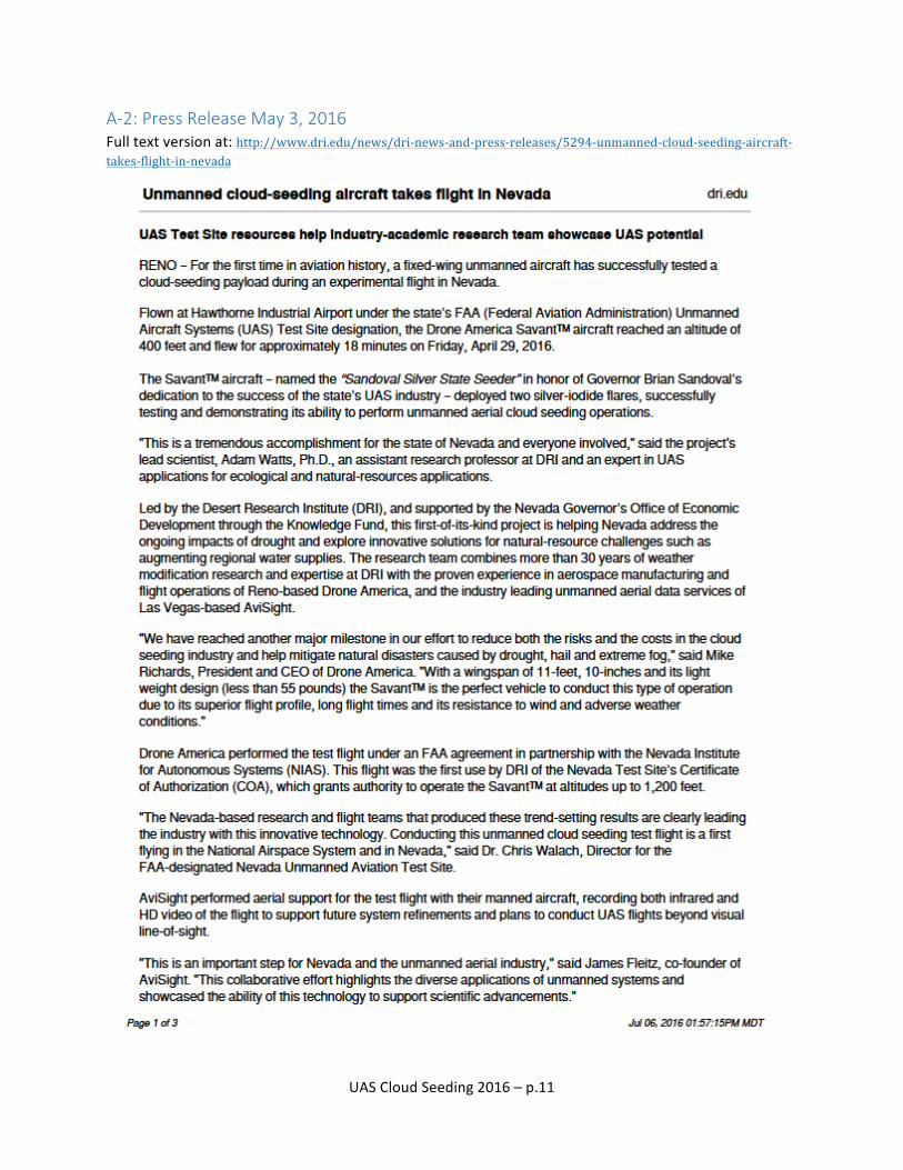
3.2.3 Fixed Wing UAS Test Flight with Cloud seeding Payload On April 29, 2016, the flight team from Drone America, DRI, AviSight and NIAS assembled at the Hawthorne Industrial Airport in Hawthorne, NV to conduct a cloud seeding flight of the Savant fixed wing UAS, named the “Sandoval Silver State Seeder.” The flight was conducted under an FAA agreement in partnership with the Nevada Institute of Autonomous Systems (NIAS), using the Nevada Test Site’s Certificate of Authorization (COA).
Prior to the flight, NIAS representatives held a safety and operational briefing for the entire team, which included two UAS pilots from Drone America, four visual observers from Drone America, a flight crew
Figure 4: Savant aircraft on swiveling trailer mount for ground test. Inset: Two silver iodide flares mounted under each wing of the Savant.
UAS Cloud Seeding 2016 – p.5
from AviSight, and observers from DRI. The AviSight flight crew operated and piloted a Cessna XXX during the test flight to ensure visual contact with the UAS and to collect aerial footage.
Following the briefing, the Cessna took off and began its flight pattern circling the airport at 1200 feet. The Savant was then successfully launched and flown by DA pilots for 18 minutes at just under 400 feet, during which time two silver iodide flares were successfully ignited and burned. The pilots then belly landed the UAS on the airstrip.
This flight represented a first-‐ever flight of a fixed wing unmanned aircraft carrying and delivering a cloud seeding payload. Examples of the press-‐release and related news coverage is provided in Appendix A-‐2. The flight was also used to collect data to develop autonomous flight programming for the aircraft. The success of the test flight can be attributed to effective working partnership between the three project partners along with NIAS representatives.
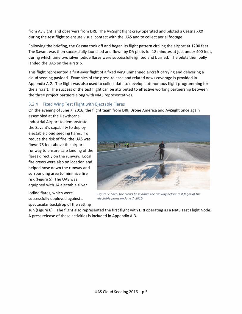
3.2.4 Fixed Wing Test Flight with Ejectable Flares On the evening of June 7, 2016, the flight team from DRI, Drone America and AviSight once again assembled at the Hawthorne Industrial Airport to demonstrate the Savant’s capability to deploy ejectable cloud seeding flares. To reduce the risk of fire, the UAS was flown 75 feet above the airport runway to ensure safe landing of the flares directly on the runway. Local fire crews were also on location and helped hose down the runway and surrounding area to minimize fire risk (Figure 5). The UAS was equipped with 14 ejectable silver
iodide flares, which were successfully deployed against a spectacular backdrop of the setting sun (Figure 6). The flight also represented the first flight with DRI operating as a NIAS Test Flight Node. A press release of these activities is included in Appendix A-‐3.
Figure 5: Local fire crews hose down the runway before test flight of the ejectable flares on June 7, 2016.

UAS Cloud Seeding 2016 – p.6
Figure 6: “The Sandoval Silver State Seeder” deploys ejectable cloud seeding flares over the Hawthorne Industrial Airport runway on the evening of June 7,2016.
3.3 Weather Forecasting for UAS Cloudseeding Operations 3.3.1 Winter 2015/2106 UAS Flight Forecasting Summary The potential for UAS cloud seeding operations over the Tahoe-‐Truckee watershed was included in daily weather forecasts from DRI’s Weather Modification team. This team maintains and communicates the ground and aircraft cloud seeding potential for the Tahoe-‐Truckee region, the Walker River Basin and locations in the Rocky Mountains. These forecasts are produced on a twice-‐daily basis throughout the winter season. An example of these forecasts for 22 January 2016 is shown in Box 1.
As part of their reporting for the 2015/2016 winter season in the Tahoe region, the team included an assessment of when and if aircraft operations could occur. During this winter season, there were 38 storms that were seeded via ground-‐based generators in the Tahoe-‐Truckee Basin. These seeding efforts are estimated to have contributed up to 20,000 acre-‐feet of water to the snowpack. However, forecasts predicted that UAS aircraft could have been used to seed nearly all of these storms along with several
Jan 22 Synopsis: Very strong zonal flow is present across the western half of the Pacific. Over the eastern Pacific a low amplitude ridge is over the western Gulf of Alaska, and a trough is just west of the West Coast from southeast Alaska to Baja. A closed low is embedded within the trough just off the northwestern CA coast with a strong southwesterly flow coming on shore across Tahoe and Walker. A high amplitude ridge extends northeast from southwestern NM to northwestern MN. Winter Park and the Laramie Range are under the ridge near the ridge axis. A strong closed low is over the Ohio Valley with a very strong flow to the south and east of the low. Tahoe/Walker: Cold topped-‐clouds (-‐60C at 250mb) are crossing the area. Cloud bases across the area are low, near 8,000’ MSL. Rain, heavy at times, has been falling all day across the lower elevations of Lake Tahoe and the Walker Basin with snow above 8,000’ MSL. Temperatures at Slide have held steady at -‐3C for most of the event with winds from the southwest (235) at 23 MPH. Down at Walker, along the Sierra Crest at 9,600’ MSL temperatures are -‐2C and have been as warm as 0C earlier today. The forecast calls for the deep moisture to continue to stream across the area for the rest of the night with a sharp cold front crossing the area late tonight. This will cool the 700mb temperatures below -‐5C and allow ground based cloud seeding to start. Tahoe ground seeding: No ops until late this evening. Tahoe UAS aircraft seeding: Cloud seeding could have been conducted all day at 14,000’MSL 20 to 25 miles from the target area. Seeding opportunities continue through the night.
Box 1: Weather forecast discussion for the Tahoe-‐Truckee project on 22 January 2016. This is a case where UAS cloud seeding was possible over an extended period while temperatures were too warm for ground based cloud seeding.

UAS Cloud Seeding 2016 – p.7
additional storms, that were either too warm at the ground generator level or had unfavorable winds for the stationary ground network.
3.3.2 UAS Forecasting Case Study DRI selected one of the storms that occurred during the Winter of 2015/2016 to evaluated as a case study for UAS-‐based cloudseeding activities.
On the afternoon of 22 January 2016 a strong storm and cold front was approaching the California coast (Figure 7) Through much of the day the Tahoe-‐Truckee area remained in the warm sector of the storm associated with a very moist atmospheric river (Figure 8). Heavy snow was observed above the 8,000 ft Mean Sea Level (MSL) and rain was observed below that level. More than 1.6 inches of snow water equivalent was measured at the Mt Rose, NV SNOTEL site. Observed cloud bases remained at approximately 8,000 ft MSL though the day. The observed temperatures at the mountain top sensor at Slide Mountain, NV were -‐3oC (26oF) and winds were from the southwest. Although the winds and cloud base heights were favorable to operate the ground based generators, the temperatures remained too warm. Cloud seeding from the UAS at 14,000 ft MSL would have placed the cloud seeding nuclei directly into the favorable temperatures of the cloud. Assuming a 10% increase in precipitation from seeding (Breed et al. 2014), up to 0.16 inches of liquid may have been added to the target snowpack from UAV cloud seeding during this 10-‐hour case alone.
Figure 7: Storm approaching the Northern California coast on the afternoon of 22 January 2016 (GOES satellite visible image).
Figure 8: Satellite, radar, surface weather map composite on the late afternoon of 22 January 2016. The atmospheric river is seen in the radar reflectivity enhancement from the Tahoe area to the southwest.
3.3.3 Development of a validation methodology During the UAS cloud seeding flight tests a key activity will be to show that the UAS has successfully delivered the cloud seeding material to the target area. A second key activity will be to show that the seeding improved the clouds snow production and potentially increased the precipitation efficiency.

UAS Cloud Seeding 2016 – p.8
A validation plan including testing the ability of the UAS’s to deliver cloud seeding material to the target area and an ice crystal image analysis was designed and tested. An initial field test was conducted on 22 March 2016 while ground based cloud seeding was active. Figure 9 shows the collection of snow in real time. This snow will be tested to detect slightly elevated levels of silver iodide to show the equipment successfully delivered the seeding plume to the target. To determine if the cloud seeding material may have changed the microstructure of the cloud, snowflake images were collected in locations both within and outside the seeding plume. Figure 10 shows snow pellets within the seeding plume from the ground-‐based generators. These same methods will be used to determine the effectiveness of the UAS seeding flights in winter 2016-‐2017.
Figure 9: Snow collection canister near Spooner Summit, NV on March 22, 2016. Snow is collected in real time and returned to DRI for trace chemical analysis.
Figure 10: Snow pellets collected near Mt Rose, NV during the UAS validation exercise on 22 March 2016.
3.3.4 Silver Iodide emissions measurements The DRI ice nucleus counter was deployed at the flight test locations to determine if the UAS seeding flights were successfully delivering potential cloud seeding silver iodide nuclei to the local flight area (Figure 11). Measurements from the instrument showed that these flights were associated with increased ice nuclei in the area during and shortly after the flights. This instrument may be deployed in the field during testing in winter 2016-‐2017.
4 Future Projects and Next Steps The fast pace of advancement by our team was largely able to accommodate the accelerated timeline for milestones and deliverables demanded within the project’s first year. In addition to the major accomplishments above, one significant achievement has been the emergence of a close working relationship and camaraderie among our team members. The advantages that this group cohesion provide are substantial and include increased efficiency of operations, smoother communications, and even an improved ability to mitigate risks or respond to emergency scenarios should these occur.
Figure 11: DRI ice nucleus counter, deployed during ground testing on Mary 6, 2016.

UAS Cloud Seeding 2016 – p.9
The team is excited to have received approval by GOED Director Steve Hill for an extension of the project’s deadline by one year, and additional funding in the amount of $400,000. This increased and extended support will allow us to demonstrate cloud seeding in the 2016-‐2017 winter season, and use the successful results to promote a commercial cloud-‐seeding venture which will be formed by our three team entities. Our activities will include developing business for this commercial venture domestically and internationally, while also pursuing the expansion of our operations using the Hawthorne Industrial Airport as a base. Such a focused area for concentrated UAS-‐cloud-‐seeding work will attract additional support for research, economic development, and other related activities which will enhance the economy of the region while our efforts promote Nevada’s UAS economy and augment the hydrology of the Walker Basin.

UAS Cloud Seeding 2016 – p.10
Appendix A – Press Releases A-‐1: Press Release February 23, 2016 Full text version at: http://www.dri.edu/news/dri-‐news-‐and-‐press-‐releases/5344-‐dri-‐unmanned-‐cloud-‐seeding-‐project-‐gains-‐ejectable-‐flare-‐capability
UAS Cloud Seeding 2016 – p.11
A-‐2: Press Release May 3, 2016 Full text version at: http://www.dri.edu/news/dri-‐news-‐and-‐press-‐releases/5294-‐unmanned-‐cloud-‐seeding-‐aircraft-‐takes-‐flight-‐in-‐nevada

UAS Cloud Seeding 2016 – p.12
A-‐3 Press Release June 23, 2016 Full text version at: http://www.dri.edu/news/dri-‐news-‐and-‐press-‐releases/5344-‐dri-‐unmanned-‐cloud-‐seeding-‐project-‐gains-‐ejectable-‐flare-‐capability