Embed Size (px)
Citation preview

tl, *PLAYS,
rý
ýONinnPSý
.1 ý' 1'. "'1 1'
DEVELOPMENT OF GUIDELINES FOR EIA ON AGRICULTURE AND INFRASTRUCTURE PROJECTS ON
PEATLANDS IN SARAWAK
Tsai Koh Fen
Master of Environmental Science (Land Use and Water Resource Management)
2004

Pusat Khidmgt Maklumat Akademik UNIVERSITI MALAYSIA SARAWAK
DEVELOPMENT OF GUIDELINES FOR EIA ON AGRICULTURE AND INFRASTRUCTURE PROJECTS ON PEATLANDS IN SARAWAK
TSAI KOH FEN
A dissertation submitted in partial fulfillment of the requirements for the degree of Master of Environmental Science in Land Use and Water Resource Management
Faculty of Resource Science and Technology UNIVERSITY MALAYSIA SARAWAK
2004

ACKNOWLEDGEMENTS
First and foremost, I wish to thank DANIDA for sponsoring, and the management of the
SLUSE-M programme for giving me the opportunity to pursue this programme.
I wish to express my deepest gratitude and appreciation to my supervisor, Prof. Murtedza
Mohamed for his guidance and advice in this research.
I wish also to thank the Deputy Chairman of NREB, YB Dr. James Dawos Mamit for his
guidance as well.
I am also most grateful to the Controller of Environmental Quality of NREB, Mr. Chong Ted
Tsiung, and the management of NREB for granting me the study leave and giving me the
opportunity to pursue my studies to this level.
Last but not least, a word of thanks to all the lecturers of this course, my colleagues,
consultants, friends and all who had directly or indirectly contributed and helped me in this
research.
i

Pusat Khiimat Maklumat Akademik UNIVERSITI MALAYSIA SARAWAK
TABLE OF CONTENTS
Acknowledgements Table of Contents List of Tables List of Figures Abstract Abstrak
INTRODUCTION 1.1 Background 1.2 Utilisation of Peatland
1.2.1 Agriculture 1.2.2 Industrial, Commercial and Housing Eestate and Infrastructure
Development 1.3 Objective of the Study 1.4 Rational of the Study
1.4.1 Problems of Development on Peat Soils 1.4.2 EIA and Existing Policy
2. LITERATURE REVIEW 2.1 Ecological and Environmental, Economic Functions of Peatlands 2.2 Peat Soil in Sarawak
2.2.1 Organic Soil 2.2.2 Genesis of Organic Soils 2.2.3 Organic Soil Classification 2.2.4 Sarawak Land Capability Classification
2.3 Peat Characteristics 2.3.1 Physical Properties of Peat 2.3.2 Chemical Properties of Peat
2.4 Humification 2.5 Bearing Capacity 2.6 Shear Strength 2.7 Water Management 2.8 Drainage 2.9 Drainability 2.10 Saline Intrusion 2.11 Watertable Requirement 2.12 Environmental Impact Assessment (EIA)
2.12.1 Legislative Requirement for EIA 2.12.2 Content of the EIA Report 2.12.3 Significant Environmental Impacts
11

2.12.4 Mitigation and Abatement Measures 2.12.5 EIA Report Review and Assessment 2.12.6 Monitoring Program
2.13 Environmental Monitoring Report 2.14 Cost-Benefit Analysis (CBA) 2.15 Selection System for Peatlands
3. STUDY METHODOLOGY 3.1 Desktop Review
3.1.1 Existing EIA Guidelines 3.1.2 EIA and EMP Reports
3.2 Field observation 3.3 Interviews
4. RESULTS AND DISCUSSION 4.1 Deficiency in EIA 4.2 Existing EIA Guidelines
4.2.1 Effects on Hydrology and Drainage Pattern 4.2.2 Impact to Public Water Supply Catchment
4.3 EIA and EMP Reports and Publications 4.3.1 Development Activities 4.3.2 Environmental Impacts and Issues and Its Mitigating Measures
4.4 Problems faced by the Environmental Consultant and Developer 4.5 Problems of Practicing Mitigating Measures
4.5.1 Waste Generation and Disposal 4.5.2 Socio-economics Aspects
4.6 Environmental Monitoring Reports
5. CONCLUSIONS AND RECCOMENDATIONS
REFERENCES PLATES APPENDIX 1:
ANNEX 1:
ANNEX 2: ANNEX 3: ANNEX 4: ANNEX 5: ANNEX 6: ANNEX 7:
Guidelines For EIA For Agriculture and Infrastructure Projects on Peatlands in Sarawak Basic Checklist Which Can Be Used To Compile The Description Of The Environmental Setting Environmental Quality Act, 1974 INWQS Interim Standard for Marine Water Quality Malaysia Air Quality Standrads General Terms and Conditions Tentative Scoring System for Different Use of Peatlands
53 54 56 57 58 59
60 60 60 63 64
65 67 68 69 70 70 73 102 105 106 106 106
108
112
111

LIST OF TABLES
Page Table 1 Distribution of Peat Swamps by District in Sarawak 2 Table 2 Utilisation of Peatland for Agriculture Development in 4
Sarawak Table 3 Peat Swamp Forest Functions, Products and Attributes 15 Table 4 Classification of Organic Soils in Sarawak 19 Table 5 Sarawak Land Capability Classification and Subclass 20 Table 6 USDA Classification based on Fibre Content 22 Table 7 Main Physical and Chemical Characteristics of Peat 30 Table 8 Chemical properties of Anderson Series 31 Table 9 Von Post Degree of Humification 32 Table 10 The Dimensions of Four Level Drainage Systems 39 Table 11 Critical Flood Duration for Agricultural Design 40 Table 12 Water Table Requirements for Crops Grown on Peat 44 Table 13 Profitability Indicators and Decision Rules Used in CBA 59 Table 14 List of EIA Guidelines Reviewed 60 Table 15 List of EIA and EMP Reports Reviewed 61 Table 16 Field Observation to Various Development Projects 63 Table 17 Various Deficiencies in EIA and EMP Reports 65 Table 18 Issues Addressed in Different EIA 68 Table 19 Activities During Different Development Project 71 Table 20 Common Activities with Drainage Projects 72 Table 21 Key Mitigating Measures Proposed in the EIA Reports and
Their Attributes 76 Table 22 The Various Crops That Are Often Considered for
Cultivation on the Peat Soils of Sarawak 78 Table 23 Recommended Width of Riparian Buffer Zone 83 Table 24 C Value for Different Type of Landuse 96 Table 25 Noise Level Generated from Equipments 98 Table 26 Noise Exposure Limit 99
iv

LIST OF FIGURES
Page Figure 1 Peat land in Sarawak 1 Figure 2 Extent of Peat Developed for Agriculture by Division 4 Figure 3 Deep peat areas within Kuching city 6 Figure 4 Proposed coastal road in Sarawak 7 Figure 5 Peat subsidence 9 Figure 6 Settlement of land surface over peat in Sibu town 10 Figure 7 Cross-section through a peat dome in Mukah Division 21 Figure 8 Cross and longitudinal sections of a peat soil 23 Figure 9 Projected relation between accumulated subsidence and time
for peat in Sarawak after the introduction of drainage 27 Figure 10 The new drainage criteria are based on groundwater runoff 36 Figure 11 Components of a drainage system 37 Figure 12 Normal and high water level criteria used 38 Figure 13 The drainability concept 41 Figure 14 Profile morphology of drained peat 42 Figure 15 EIA review process in NREB 55 Figure 16 Relationship between water table depth and the water level in
the field drains 79 Figure 17 Cut-off drain and perimeter drain 81 Figure 18 The proposed construction of raft foundation on peat 89
V

ABSTRACT
In Sarawak, peatlands comprises about 13% or 1.66 million ha of the State's total land area. Due to the rapid growth of commercial agriculture development and urbanization, these peatlands are encroached and exploited. More peatlands, including deep peat areas, are anticipated to be alienated for economic development in future, especially following the completion of the proposed coastal trunk road. These developments are expected to result in some unfavourable effects on the fundamental ecological functions and environmental services of peatlands. EIA study is a requirement provided for under the Sarawak NREO 1993. Certain development activities on peatlands are prescribed activities requiring submission of EIA report prior to implementation. Due to the unique characteristics of peatlands, specialised guidelines are deemed necessary for the preparation of EIAs on development activities in peat areas. Such guidelines, which are eful to consultants and proponents of projects on peatlands, are yet to be made available) This dissertation work attempts at developing a set of guidelines specific for agricultural, infrastructural and real- estate developments on peatlands. The study involves collation and review of EIA, EMP and EMR reports, literature, and other relevant guidelines and publications related to peatlands development. Field visits to selected plantations, road and housing construction sites, and interview and discussion with selected environmental consultants, developers and contractors have also been conducted. The key environmental effects associated with peatlands development identified include peat subsidence and compaction, irreversible drying of peat and fire hazard. Other major effects are alterations of peat hydrology which include reduction of dry season flow, saline intrusion during dry season, and increased stream flow and flooding hazard during wet season. Also pertinent are degradation of water quality, air pollution during land clearing, decrease in the size of water supply catchment, draw down of ground water level, loss of water resources, loss of flora and fauna, loss of habitat and biodiversity, and micro-climate change. Intensive agriculture on peatlands also results in the problem of agrochemical contamination of both the surface and ground water. Technological and information gaps and specialised guidelines are the main constraints for the environmental consultants and project developers to prepare good EIA reports. Therefore, a good set of guidelines is needed to ensure that impact assessment exercises appropriately address aspects pertinent to the peat environment. In the case of agriculture development, such guidelines would facilitate planning and designing of more environmentally friendly technology or methods of land clearance, drainage and irrigation, tilling and planting as each of these activities are elements which could have impact on the environment and the sustainability of the land resource. The guidelines, as developed by this study, is intended at improving the effectiveness of the present EIA procedure through assisting project proponents in better defining the scope, enhancing the quality of an EIA study and its report by ensuring focus on aspects relevant to the unique and fragile peatlands.
VI

ABSTRAK
Paya gambut merangkumi 13% ataupun 1.66 juta ha daripada jumlah kawasan tanah di Sarawak. Kawasan paya gambut ini telah dibuka dan diterokai akibat daripada perkembangan yang pesat dari segi pembangunan pertanian secara komersial dan proses urbanisasi. Berikutan dengan siapnya jalanraya pantai yang dicadangkan, dijangka lebih banyak paya gambut termasuk paya gambut yang dalam akan digunakan untuk pembangunan ekonomi. Pembangunan ini dijangka akan menghasilkan kesan-kessan yang tidak diingini terhadap fungsi asas ekologi dan perkhidmatan alam sekitar daripada paya gambut. EIA merupakan kajian yang diperlukan di bawah NREO Sarawak 1993. Aktiviti-aktiviti tertentu yang merupakan aktiviti terjadual di mana pengemukaan laporan EIA adalah diperlukan untuk tujuan perlaksanaan. Disebakan ciri-ciri paya gambut adalah unik, maka garispanduan yang khusus diperlukan untuk penyediaan EIA bagi aktiviti-aktiviti pembangunan di paya gambut. Garispanduan seperti ini yang berguna kepada pihak perunding dan pemaju projek di kawasan paya gambut masih belum dibangunkan. Kerja disertasi ini bertujuan untuk membangunkan satu set garispanduan yang khusus untuk pembangunan pertanian, infrastruktur dan perumahan di atas paya gambut. Kajian ini melibatkan ulasan dan rujukan laporan EIA, EMP dan EMR, penulisan, garispanduan garispanduan dan dokumen-dokumen lain yang berkaitan dengan pembangunan paya gambut. Lawatan ke ladang, tapak pembinaan rumah, jalanraya yang terpilih dan temuduga dengan perunding persekitaran, pemaju dan kontraktor juga diadakan. Kesan-kesan alam sekitar yang utama akibat pembangunan paya gambut adalah termasuk penurunan paras tanah paya gambut serta mampatan, kekeringan gambut yang tidak dapat dipulihkan dan risiko kebakaran. Kesan-kesan lain yang berkaitan adalah penukaran hidrologi paya yang membawa penurunan pengaliran musim kering, kemasukkan air masin dari laut pada musim kering dan peningkatan aliran sungai dan risiko banjir pada musim hujan. Kesan-kesan lain yang berkaitan juga termasuk penurunan kualiti air, kualiti udara semasa pembukaan tanah, pengecilan salz kawasan tadahan bekalan air, penurunan air bawah tanah, kehilangan sumber air, kehilangan flora dan fauna, kehilangan habitat dan kepelbagaian biologi dan juga penukaran cuaca mikro. Pertanian intensif akan mengakibatkan masalah pencemaran bahan kimia ke alas air permukaan dan bawah tanah. Jurang teknologi, pengetahuan dan garispanduan merupakan halangan utama bagi perunding dan pemaju untuk meydiakan laporan EIA yang baik. Dengan ini, satu set garispanduan yang baik adalah perlu untuk memastikan proses penilaian impak dapat mengenalpastikan aspek-aspek yang berkaitan dengan persekitaran paya gambut. Dari segi pembangunan pertanian, gaispanduan ini dapat memudahkan perancangan dan perekaan teknologi dan cara-cara pembersihan tanah, pengaliran dan saliran, pencucukan dan penanaman alam sekitar yang lehih mesra kerana aktiviti-akitiviti tersebut adalah elemen-elemen yang mempunyai impak ke atas alam sekitar dan kemampanan sumber tanah. Garispaduan yang dibangunkan daripada kajian ini bertujuan untuk meningkatkan keberkesanan prosedur EM yang sedia ada dengan cara membantu pemaju projek untuk mendefinisikan skop dengan lebih baik, meningkatkan kualiti kajian EIA dan melaporkannya berdasarkan aspek-aspek yang berkaitan dengan paya gambut yang unik dan mudah terdedah kepada kerosakan.
vii

Development of Guidelines for EIA on Agriculture and Infrastructure Projects on Peatlands in Sarawak
1. INTRODUCTION
1.1 Background
There are about 1.66 million hectares of peat swamps in Sarawak; that account for about
13% of the State's total land area (Tie & Kueh, 1979; Figure 1).
Figure 1: Peat land in Sarawak (Ten, 2002)
The peatlands in Sarawak can be divided into five main regions based on the following
river systems (Sime Darby Services, 1998):
Batang Samarahan-Batang Sadong Region (127,562 hectares); Batang Lupar-Batang Krian Region (335,308 hectares); Rajang-Tatau Region (828,366 hectares); Batang Baram Region (295,995 hectares); and Suai-Sibuti Region (110,616 hectares).
I

As shown in Table 1, Sibu, Sri Aman, Miri and Samarahan Divisions have most of the
peat swamps in Sarawak (In 2002, Sri Aman Division was divided into Sri Aman and
Betong Divisions and Sibu Division was divided into Sibu and Mukah Divisions).
Table 1: Distribution of Peat Swamps by District in Sarawak
Region Shallow Deep peat
Total area
, eat ha.
Western Kuching Division 3,326 19,723 23,049
Samarahan Division 27,821 164,954 192,775 Sri Aman Division 40,853 242,223 283,076
Central Sibu Division 43,300 497,500 540,800
Sarikei Division 28,500 141,400 169,900
Kapit Division - - - Northern Bintulu Division 9,852 136,269 146,121
Miri Division 18,648 257,931 276,579
Lirabang Division 9,800 15,500 25,300
Total 182,100 1,475,500 1,657,600
(Source: Tie & Kueh, 1979)
Lately, a substantial area of peat swamp has been reclaimed for plantation and other
development projects. More peatlands, including deep peat areas, are anticipated to be
alienated for plantations in future. The State Government is also putting in more roads
linking all the coastal regions of Sarawak where at many localities crossing over peatland
thereby segmenting the existing peat swamp forest. With the improved accessibility,
especially along the proposed coastal highway, more peatlands along the road are also
subjected to further exploitation. These development projects on the peatlands would
2

bring about changes in both physical and chemical properties of the land whereby the
sustainability of its economic and ecological values will be affected.
Peat swamps play many vital ecological roles, among others, in maintenance of
biodiversity, climate stabilization, regulation of hydrology and act as buffer against salt-
water intrusion (Phillips, 1997). In many coastal regions the peat swamps also serve as
fresh water reservoirs for potable purpose (Ong & Mailvaganam, 1992).
Water is the element that governs the characteristics and behaviours of the peat. Drainage
is a prerequisite for the reclamation of any peatland for agriculture and infrastructure
development. However, when peat is drained, the characteristics of the soil will be
irreversibly altered and subsidence will occur.
1.2 Utilisation of Peatland
1.2.1 Agriculture
Figure 2 below shows the total peat area that had been developed for agriculture.
Expansion of agriculture onto peatlands had intensified markedly as demand for
plantation crops continue to increase. Since 1987, a total of 467 097 ha of peat swamps in
Sarawak had been alienated by the Government for agricultural development and
reforestation (Mellling, 1999).
3

i00, Oß0 300, OEp 30O; OO0 aOU, iiAO Atcs fu)
$Oa, Gß0
Figure 2: Extent of Peat Developed for Agriculture by Division (Melling, 1999)
Melling et al. (1998) stated that there are already 534,685 ha of peatlands in Sarawak
being utilised for the agriculture development. Besides the alienated land for plantation,
67,588 ha were developed by smallholders. Among the alienated land 66% was used for
oil palm plantation, 24% are for reforestation and 9% for sago plantation as shown in
Table 2.
Table 2: Utilisation of Peatlands for Agriculture Development in Sarawak
Type Of 0p s Alicna Laud m liltold (ha) Total Arm (ba) Oil Palm 306,042 24,627 330,669 Reforestation 111,615 - 111,615 Sago 40,568 23,661 64,229 Rubber 5 000 18,000 23,000 Padi 2,000 1,300 2,000 Pineapples 595 - 1,895 Tapioca 808 - 808 Vegetables 100 - 100 Miscellaneous 369 - 369 TOTAL 467,097 67,588 534,685
(Source: Melling et a1., 1999)
4

Pusat Khidmat Makiumat Akademik UNI VERSITI MALAYSIA SARAWAK
Drahman (1999) reported that the State's target for agricultural plantation development in
term of actual planted area by the Year 2020 is at 2,000,000 acres on State land and
Native Customary Rights (NCR) land (250,000 acres for sago and 1,750,000 for oil palm
and others). This implies that a significant amount of peat swamps, which are originally
under forest, will be converted.
1.2.2 Industrial, Commercial, Housing Estate and Infrastructure Development
Apart from commercial agriculture, peatlands in Sarawak has also been subjected to other
development activities such as infrastructure development, real estate development and
public utilities (Mamit & Sawal, 2003). The urban areas in Sarawak, particularly the
Kuching and Sibu Divisions, are developing rapidly, due to rural/urban migration and
intense business development (Philip, 1997). Some of the ongoing developments of
residential, business and shopping centers and industrial estates are established on
reclaimed peatlands. Avoidance of using peatlands is sometimes possible by changing the
location of the construction. However, in growth centres and fast developing areas, this
approach works for sometime but ultimately the pressure for land development causes the
less desirable land to also be developed (Jarrett, 1997). The Batu Kawa New Township
for an example occupies some 214 ha of peatland in Kuching City.
According to Lynghus and Larsen (2004), Kuching City is located on relatively flat
terrain along the surrounding rivers and streams. Large parts of the city are founded on
unstable ground (peat swamp or soft clay) and most of the residential areas are within the
5

catchments to Sungai Sarawak upstream of the barrage. Figure 3 shows the housing estate
areas in some locations in the western parts of the Kuching city and along the Matang
Road, which are located at a varying depth of peat soils. It is estimated that this area
compromises about 1,800 to 2,000 ha of peat soil.
Figure 3: Deep peat areas within Kuching city (Lynghus & Larsen, 2004)
Under the 7 Malaysia Plan (1996 - 2000), the Government has proposed the construction
of second trunk road in Sarawak to provide better linkage to settlements and towns
scattered along the coast. The coastal road is to promote socio-economic growth and
improve the standards of living of the riverine communities, in line with the vision to
make Sarawak a developed state by 2020 in tandem with the other states in Malaysia.
This 1167-kilometre Sarawak Coastal Road Network is to start from Sematan in Lundu to
Bakam in Miri, crosses many coastal peat swamps especially in Kuching, Samarahan, Sri
Aman, Betong, Sarikei, Sibu, Mukah and Miri Divisions as shown in Figure 4.
6

Figure 4: Proposed coastal road in Sarawak
1.3
Besides, about 30% of the new access road to the proposed Federal Administrative
Centre in Matang cut through peat overlying soft clay areas.
The current road construction method in deep peat is to first, construct drains alongside
the road reserve during the dry season and then grading the road over 2-3 years by regular
topping with sandy fill. Geotextile is commonly used to permit faster road construction
and reduce embankment settlement and deformation (Sime Darby Services, 1998).
Objective of the Study
The overall goal of this study is to develop guidelines for Environmental Impact
Assessment (EIA) for agriculture and infrastructure projects on peatlands in Sarawak to
ensure that impact assessment exercises appropriately address aspects pertinent to the
7

peat environment. Such guidelines are indeed relevant in terms of facilitating least
impacts and more sustainable land development activities on the unique and fragile
peatlands.
The specific objectives are:
(i) To collate all existing legislation and regulations relevant to the management of
peatland in Sarawak;
(ii) To identify the environmental impacts of agriculture and infrastructure developments
on peatland;
(iii)To examine the present development and management practices of peatland to
mitigate environmental impacts and to ensure sustainability; and
(iv)To formulate effective guidelines that can be used for the preparation on EIAs on
agricultural and infrastructure developments on peatlands. The guidelines shall
present strategy frameworks for least impact approaches to be adopted for such
development activities on peatlands.
1.4 Rational of the Study
1.4.1 Problems of Development on Peat Soils
The agriculture development and urbanization in major towns in Sarawak are
encroaching into the peatlands areas. Tek et al. (2001) stated that this situation is mainly
because of the increasing shortages of good agriculture land for further development, the
8
flat topography and its occurrence close to the population centers and/or existing cropped
areas.
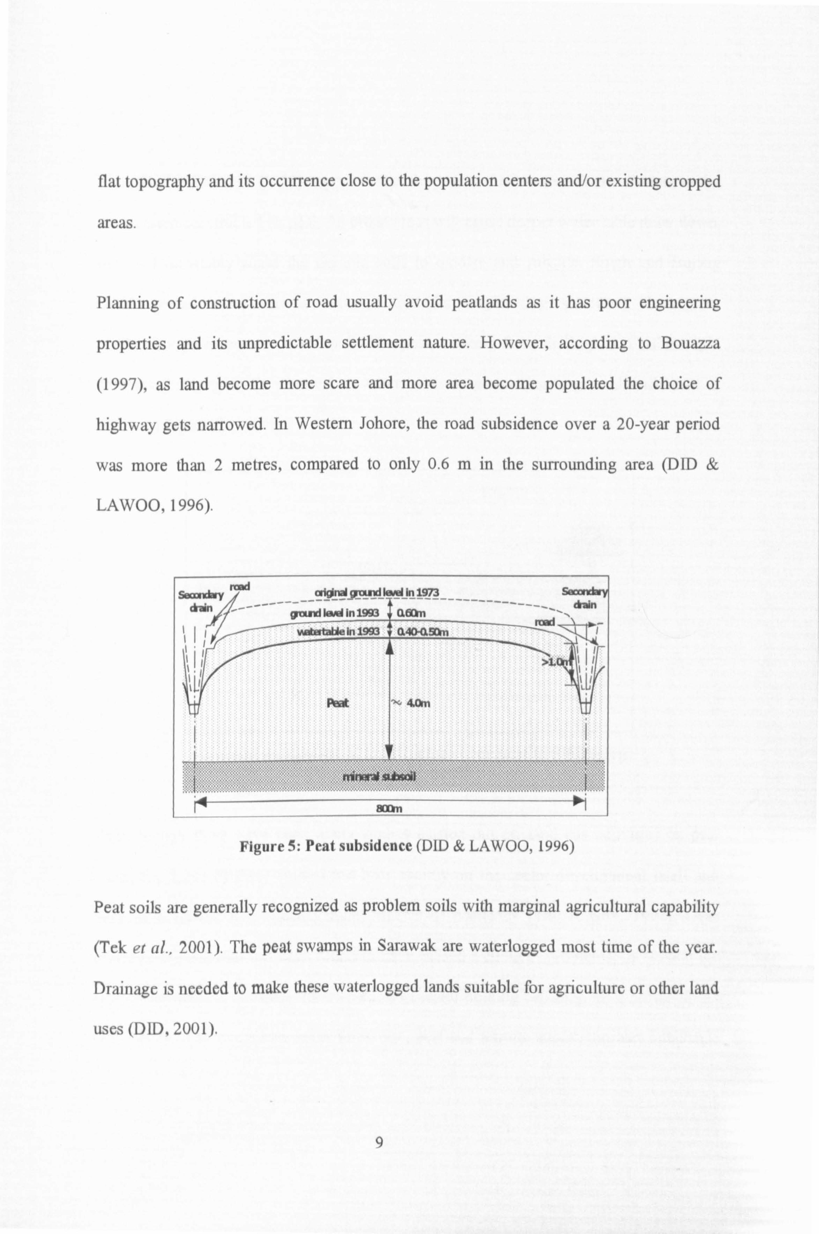
Planning of construction of road usually avoid peatlands as it has poor engineering
properties and its unpredictable settlement nature. However, according to Bouazza
(1997), as land become more scare and more area become populated the choice of
highway gets narrowed. In Western Johore, the road subsidence over a 20-year period
was more than 2 metres, compared to only 0.6 m in the surrounding area (DID &
LAWOO, 1996).
Figure 5: Peat subsidence (DID & LAWOO, 1996)
Peat soils are generally recognized as problem soils with marginal agricultural capability
(Tek et al., 2001). The peat swamps in Sarawak are waterlogged most time of the year.
Drainage is needed to make these waterlogged lands suitable for agriculture or other land
uses (DID, 2001).
9

Sime Darby Services (1998) reported that the town of Sibu and Taman Paderi in Sri
Aman were constructed on peat. As urban areas will cause deeper water table draw down,
this will inevitably cause the organic soils to oxidise and subside. Singh and Bujang
(2003) stated some serious consequences for engineering structures from poor
mechanical performance on soft soils like peat resulting from the high and rather rapid
compressibility upon the removal of water by drainage leading to ground settlement as
shown in Figure 6.
Figure 6: Settlement of land surface over peat in Sibu town (Singh & Bujang, 2003)
Even though there have been many studies carried out on land use activities on peat
areas, the focus of these studies has been mainly on the sector development itself and
very little on the water management aspects of peatlands (Tan & Sim, 1998). Over
drainage of peatlands has been found to have caused a chain of problems, increasing the
rate of subsidence, flooding, the reduction of water holding capacity, an increase in the
occurrence of acid-sulphate soils, forest fire, pest and termite attack, nutrient imbalance
10

and decrease in the crop yield. Studies have been shown that these problems will
significantly shorten the economic usefulness of the land (Melling, 1999,1999b).
Sarawak has a dominant area of peatlands with peat layer of more than 2.5m deep (Teng,
1994); the depth of peat could reach 20m (Tie & Kueh, 1979). Thereby with continuous
drainage, peat subsidence is considerable and it has substantial effect on the sustainable
use of the peatland and the life span on any physical structures put on it.
Check (1999) found that technological gap is the main constraints in peatlands
development where current Resaerch and Development (R&D) activities on peatlands are
skewed toward agriculture development fields and very marginal effort had been placed
on civil, mechanical, and hydrological engineering related R&D.
Land use and development activities have and will continue to have a significant impact
on the State's water resource from peatland where the peat aquifer could easily be
destroyed through excessive drainage and over-exposure to solar radiation (Ong &
Yogeswaran, 1991).
1.4.2 EIA and Existing Policy
Sarawak is the first state in Malaysia to enact its own laws on environmental protection
and natural resources management where EIA study is required under the provisions of
the Section 11A (1), Natural Resources and Environment Ordinance (NREO) (Chapter
11

84, Laws of Sarawak) for development activities or so called 'Prescribed Activities"
which are having impacts on the environment. The EIA report has to be submitted to the
Natural Resources and Environment Board Sarawak (NREB) for approval and the NREB
will only then give permission in writing for such activities to be undertaken or
commenced; and the person or project developer has to undertake in writing to comply
with the orders or directives of the NREB. As such, serious considerations have to be
taken while planning for development in the peatlands and expensive management
practices have to be adopted.
Although abatement and mitigating measures are an integral part of the EIA reports,
relevant critical issues of the project and site are always ignored as the issues depend very
much on the ability of the EIA team to capture them where good field survey, literature
review, consultation with the relevant authorities and discussion with the local people are
required. According to Mohamed et al. (2002), the feasibility/applicability and
effectiveness of these recommended measures are seldom assessed and evaluated.
According to Drahman (1999), one of the measures taken by the Government to reduce
water management problems in commercial development of peat is to prepare guidelines
on processes and procedures in undertaking plantation development in peat areas. This is
to be undertaken by the Ministry of Land and Rural Development together with relevant
research agencies and departments including Crop Research and Application Unit
12

(CRAUN), Palm Oil Research PORIM, Department of Drainage and Irrigation (DID) and
NREB.
Besides, guidelines on EIA study that are available at the moment are general in nature
and are inadequate to address peat related environmental problems. Coupled to that, EIA
is only project-based without looking into cumulative impacts that are particularly
pronounced for peatlands.
Ten (2002) suggested that guidelines on peatlands utilization and development needed to
be developed to cover every aspect as comprehensively as possible. The do's and don'ts
in peatlands should be clearly specified so that the relevant parties could know clearly
what needs to be followed. Good guidelines also enable planning and designing a more
environmentally friendly technology or methods of land clearance, drainage and
irrigation, tilling and planting as each of these activities are elements which could have
impact on the environment and the sustainability of the land.
13

2. LITERATURE REVIEW
2.1 Ecological, Environmental and Economic Functions of Peatlands
Peatlands provide fundamental ecological functions and environmental services including
the regulation of water regimes and provision of habitats for fauna and flora (Riley and
Page, 2001). As reported by Sebastian (2001), there are a total of 44 species of mammals
and 197 species of birds in the peat swamp forests of East Malaysia, and for Sarawak,
57.6 % of globally threatened birds occur in dry and wet lowland forests which makes
forested lowlands the highest priority for conservation in the State.
The vegetation found in the peatswamp forests of Sarawak are Alan Forest, Alan Bunga
forset and Padang Alan forest. The wildlife therein includes bats, primates, rodents, wild
pigs, mousedeer, samber deer, langurs, gibbons, macaques and Orang Utan (Philip,
1997).
Peatlands is able to maintain the quality of fresh water and prevent saline intrusion into
agricultural lands. Peatlands stores large quantities of organic matter, thus plays an
important role in the global carbon balance since one-third of all global carbon is held in
peatlands (Mamit, 1999).
The importance of peatlands as summarised by Tek et al. (1998), Chai (1999) and Lim
and Tan (1999) in terms of its functions, products and attributes are given in Table 3.
14

Table 3: Peat Swamp Forest Functions, Products and Attributes
` tal. 159$ G, 3 t __ ., Groundwater " Hydrologic flux and storage Direct use
recharge -Aquifer -Timber Groundwater -Water storage reservoir and -Non-timber forest
discharge regulator products (including fish) Flood control -Regional stream hydrology -Recreation Sediment/ -Regional climate control -Nature or ecotourism
toxicant Biological productivity -Education and research retention -Net primary productivity -Human habitat
Nutrient -Carbon storage Indirect use retention -Carbon fixation -Carbon store
Recreation/ -Secondary productivity -Water regulation tourism Biogeochemical cycling -Coastal protection/buffer
Resources and storage -Air and water pollution Agriculture -Nutrient source or sink reduction
resources C, N, S, P, ete transformation -Microclimate function Water supply -Sediment and organic matter -Wildlife habitat Biological reservoir (including birds and
diversity Decomposition aquatic species) Uniqueness to -Carbon release Option values
culture/ heritage -Detritus output for aquatic -Premium to preserve organisms future direct and indirect
-Mineralization and release of uses N, S, C, etc Non-use values Community/wildlife habitat -Forests as objects of -Habitat for species intrinsic value -Biodiversity -Endangered species
-Threatened habitats/ecosystems -Cherished landscapes -Cultural heritage
Sime Darby Services (1998) argued that in spite of the numerous problems associated
with organic soils in Sarawak, they are suitable for development because of the following
favourable characteristics:
(i) Extensive acreage: organic soils cover about 13% of the total land area which is a
sizeable proportion of state land base;
15