Embed Size (px)
Citation preview
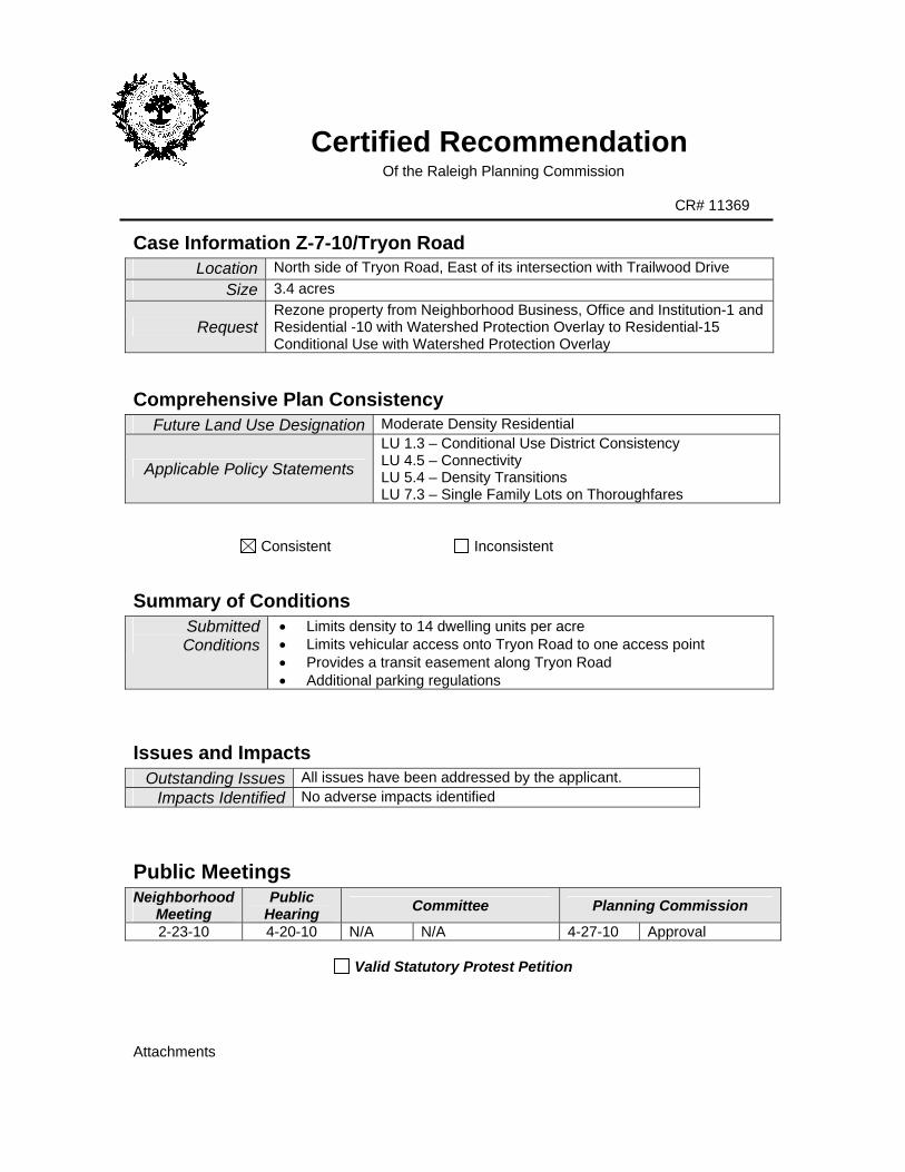
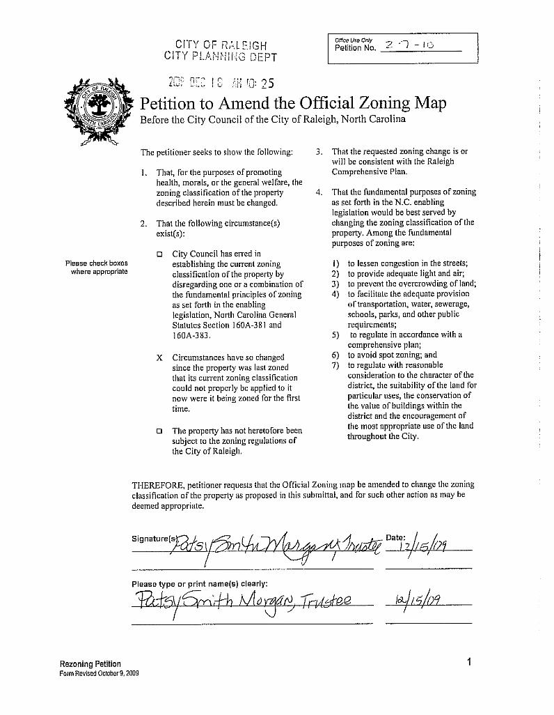
Certified Recommendation Of the Raleigh Planning Commission
CR# 11369
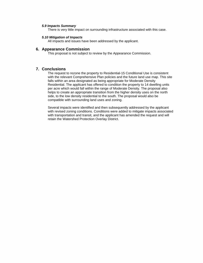
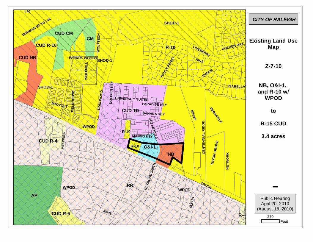
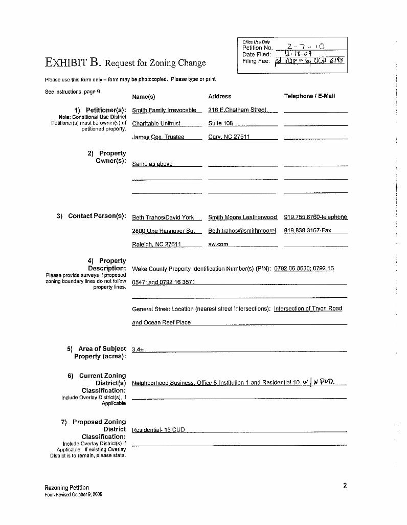
Case Information Z-7-10/Tryon Road Location North side of Tryon Road, East of its intersection with Trailwood Drive
Size 3.4 acres
Request Rezone property from Neighborhood Business, Office and Institution-1 and Residential -10 with Watershed Protection Overlay to Residential-15 Conditional Use with Watershed Protection Overlay
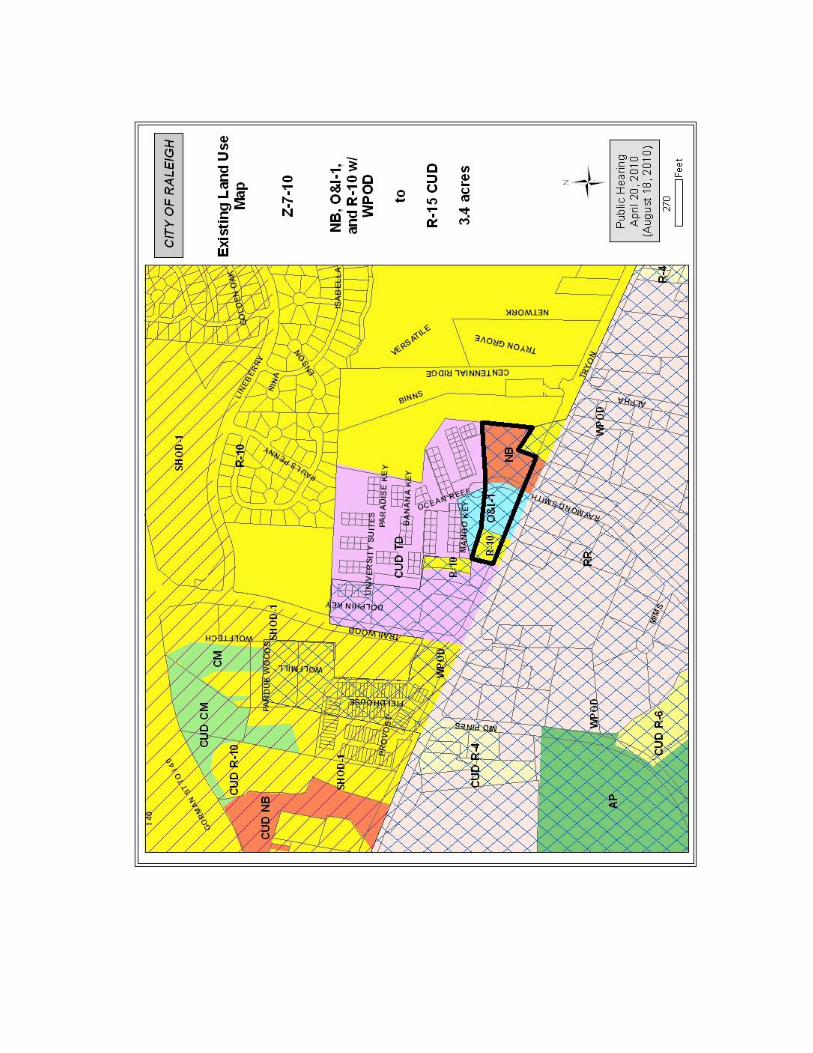
Comprehensive Plan Consistency Future Land Use Designation Moderate Density Residential
Applicable Policy Statements LU 1.3 – Conditional Use District Consistency LU 4.5 – Connectivity LU 5.4 – Density Transitions LU 7.3 – Single Family Lots on Thoroughfares
Consistent Inconsistent
Summary of Conditions Submitted
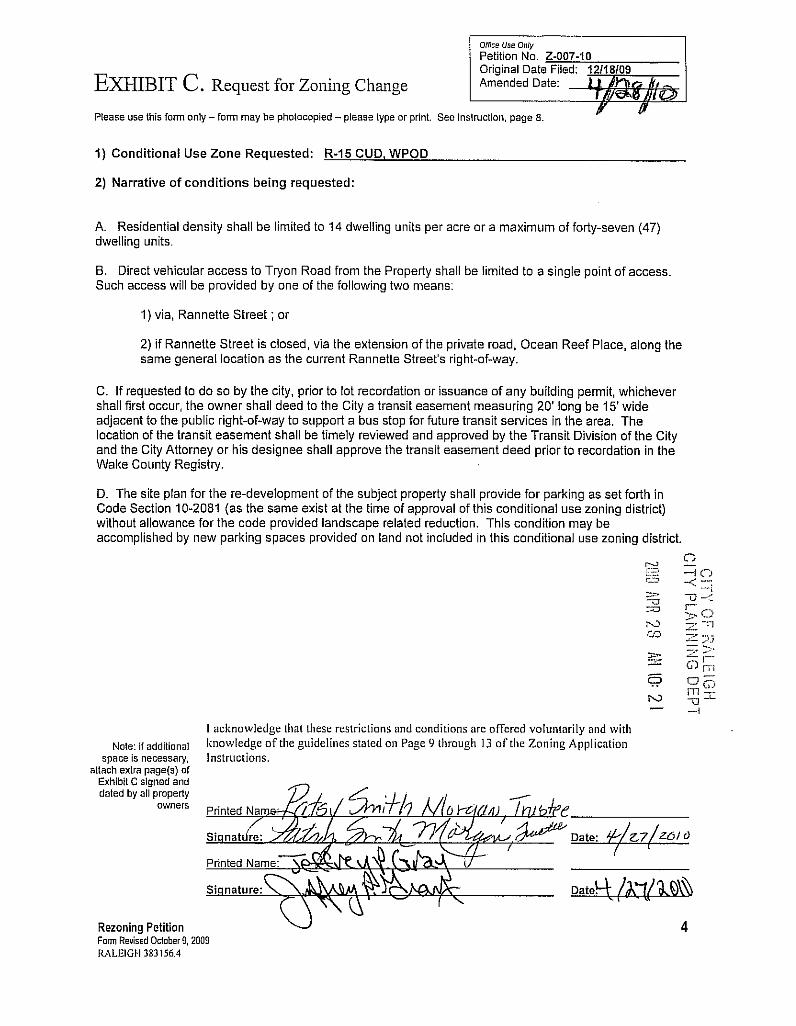
Conditions • Limits density to 14 dwelling units per acre • Limits vehicular access onto Tryon Road to one access point • Provides a transit easement along Tryon Road • Additional parking regulations
Issues and Impacts Outstanding Issues All issues have been addressed by the applicant.
Impacts Identified No adverse impacts identified
Public Meetings Neighborhood
Meeting Public
Hearing Committee Planning Commission
2-23-10 4-20-10 N/A N/A 4-27-10 Approval
Valid Statutory Protest Petition
Attachments
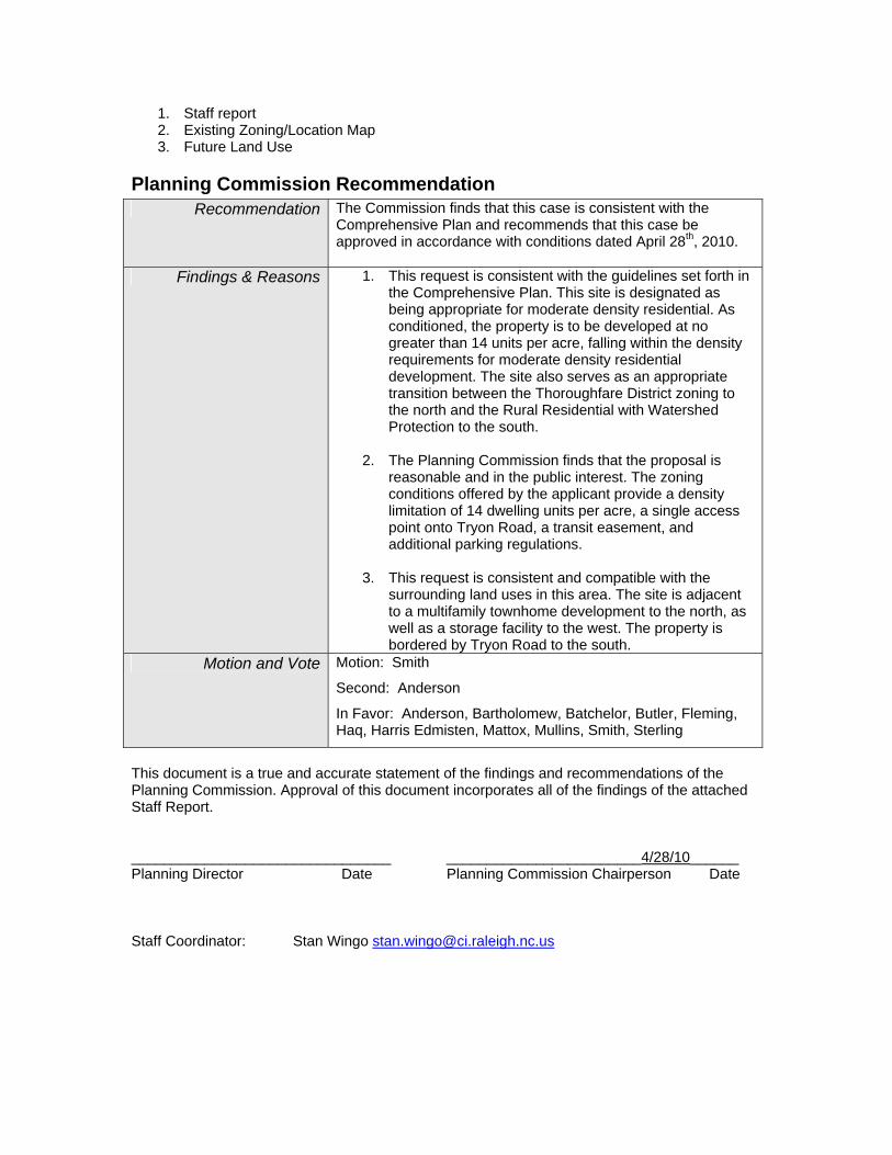
1. Staff report 2. Existing Zoning/Location Map 3. Future Land Use
Planning Commission Recommendation Recommendation The Commission finds that this case is consistent with the
Comprehensive Plan and recommends that this case be approved in accordance with conditions dated April 28th, 2010.
Findings & Reasons 1. This request is consistent with the guidelines set forth in the Comprehensive Plan. This site is designated as being appropriate for moderate density residential. As conditioned, the property is to be developed at no greater than 14 units per acre, falling within the density requirements for moderate density residential development. The site also serves as an appropriate transition between the Thoroughfare District zoning to the north and the Rural Residential with Watershed Protection to the south.
2. The Planning Commission finds that the proposal is
reasonable and in the public interest. The zoning conditions offered by the applicant provide a density limitation of 14 dwelling units per acre, a single access point onto Tryon Road, a transit easement, and additional parking regulations.
3. This request is consistent and compatible with the
surrounding land uses in this area. The site is adjacent to a multifamily townhome development to the north, as well as a storage facility to the west. The property is bordered by Tryon Road to the south.
Motion and Vote Motion: Smith
Second: Anderson
In Favor: Anderson, Bartholomew, Batchelor, Butler, Fleming, Haq, Harris Edmisten, Mattox, Mullins, Smith, Sterling
This document is a true and accurate statement of the findings and recommendations of the Planning Commission. Approval of this document incorporates all of the findings of the attached Staff Report. ________________________________ ________________________4/28/10______ Planning Director Date Planning Commission Chairperson Date Staff Coordinator: Stan Wingo [email protected]
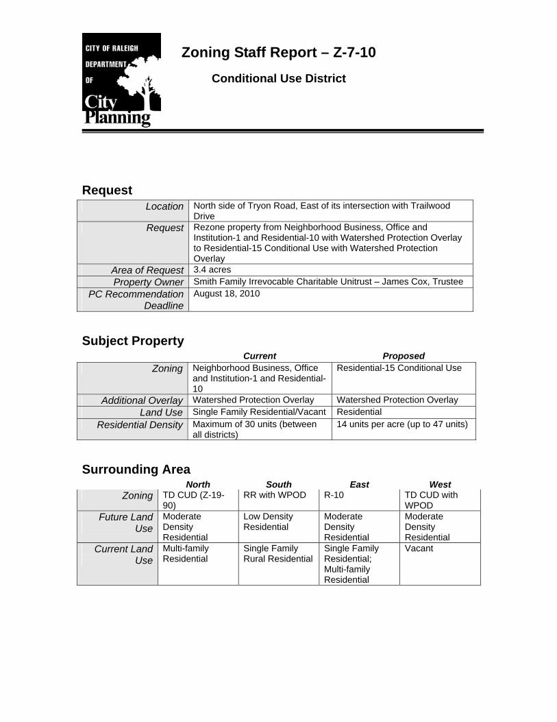
Zoning Staff Report – Z-7-10 Conditional Use District
Request Location North side of Tryon Road, East of its intersection with Trailwood
Drive Request Rezone property from Neighborhood Business, Office and
Institution-1 and Residential-10 with Watershed Protection Overlay to Residential-15 Conditional Use with Watershed Protection Overlay
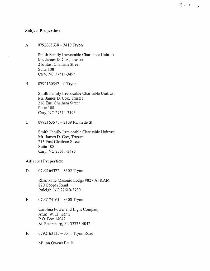
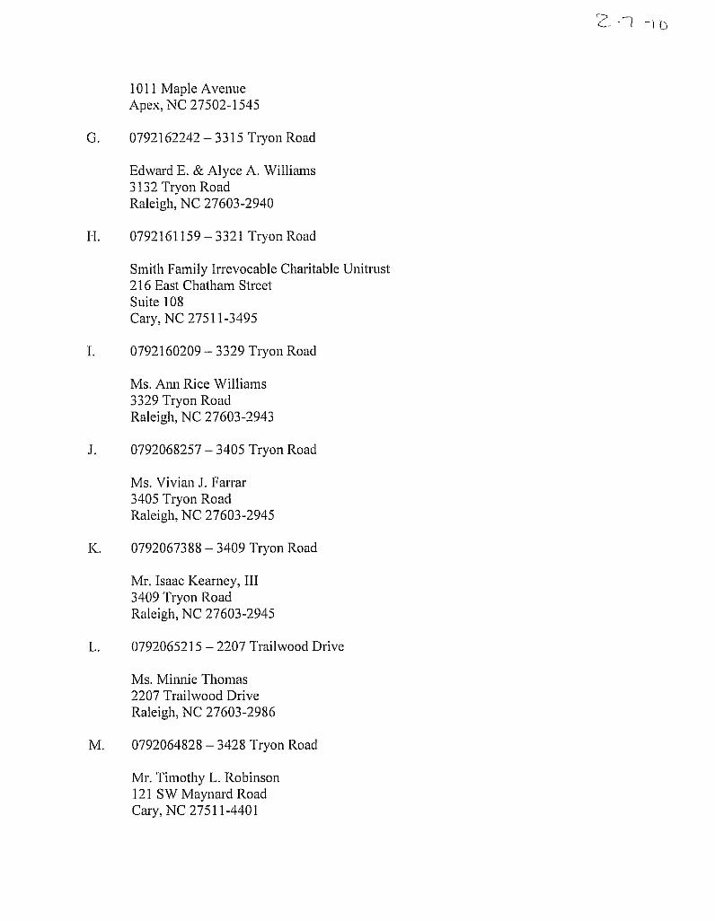
Area of Request 3.4 acres Property Owner Smith Family Irrevocable Charitable Unitrust – James Cox, Trustee
PC Recommendation Deadline
August 18, 2010
Subject Property Current Proposed
Zoning Neighborhood Business, Office and Institution-1 and Residential-10
Residential-15 Conditional Use
Additional Overlay Watershed Protection Overlay Watershed Protection Overlay Land Use Single Family Residential/Vacant Residential
Residential Density Maximum of 30 units (between all districts)
14 units per acre (up to 47 units)
Surrounding Area North South East West
Zoning TD CUD (Z-19-90)
RR with WPOD R-10 TD CUD with WPOD
Future Land Use
Moderate Density Residential
Low Density Residential
Moderate Density Residential
Moderate Density Residential
Current Land Use
Multi-family Residential
Single Family Rural Residential
Single Family Residential; Multi-family Residential
Vacant
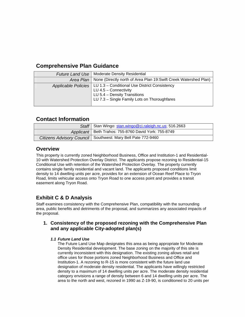
Comprehensive Plan Guidance
Contact Information Staff Stan Wingo: [email protected]; 516.2663
Applicant Beth Trahos: 755-8760 David York: 755-8749 Citizens Advisory Council Southwest: Mary Bell Pate 772-9460
Overview This property is currently zoned Neighborhood Business, Office and Institution-1 and Residential-10 with Watershed Protection Overlay District. The applicants propose rezoning to Residential-15 Conditional Use with retention of the Watershed Protection Overlay. The property currently contains single family residential and vacant land. The applicants proposed conditions limit density to 14 dwelling units per acre, provides for an extension of Ocean Reef Place to Tryon Road, limits vehicular access onto Tryon Road to one access point and provides a transit easement along Tryon Road.
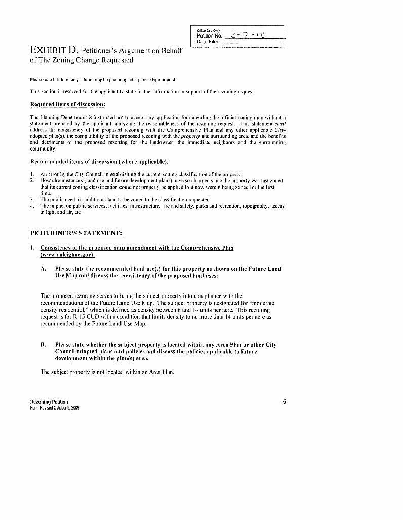
Exhibit C & D Analysis Staff examines consistency with the Comprehensive Plan, compatibility with the surrounding area, public benefits and detriments of the proposal, and summarizes any associated impacts of the proposal.
1. Consistency of the proposed rezoning with the Comprehensive Plan and any applicable City-adopted plan(s)
1.1 Future Land Use
The Future Land Use Map designates this area as being appropriate for Moderate Density Residential development. The base zoning on the majority of this site is currently inconsistent with this designation. The existing zoning allows retail and office uses for those portions zoned Neighborhood Business and Office and Institution-1. A rezoning to R-15 is more consistent with the future land use designation of moderate density residential. The applicants have willingly restricted density to a maximum of 14 dwelling units per acre. The moderate density residential category envisions a range of density between 6 and 14 dwelling units per acre. The area to the north and west, rezoned in 1990 as Z-19-90, is conditioned to 20 units per
Future Land Use Moderate Density Residential Area Plan None (Directly north of Area Plan 19:Swift Creek Watershed Plan)
Applicable Policies LU 1.3 – Conditional Use District Consistency LU 4.5 – Connectivity LU 5.4 – Density Transitions LU 7.3 – Single Family Lots on Thoroughfares
acre within its Thoroughfare District Conditional Use zoning classification, and is developed as a multifamily townhome development.
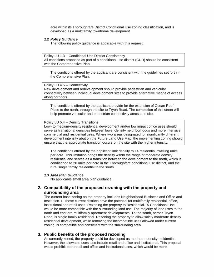
1.2 Policy Guidance The following policy guidance is applicable with this request:
Policy LU 1.3 – Conditional Use District Consistency All conditions proposed as part of a conditional use district (CUD) should be consistent with the Comprehensive Plan.
The conditions offered by the applicant are consistent with the guidelines set forth in the Comprehensive Plan.
Policy LU 4.5 – Connectivity New development and redevelopment should provide pedestrian and vehicular connectivity between individual development sites to provide alternative means of access along corridors.
The conditions offered by the applicant provide for the extension of Ocean Reef Place to the north, through the site to Tryon Road. The completion of this street will help promote vehicular and pedestrian connectivity across the site.
Policy LU 5.4 – Density Transitions Low- to medium-density residential development and/or low impact office uses should serve as transitional densities between lower-density neighborhoods and more intensive commercial and residential uses. Where two areas designated for significantly different development intensity abut on the Future Land Use Map, the implementing zoning should ensure that the appropriate transition occurs on the site with the higher intensity.
The conditions offered by the applicant limit density to 14 residential dwelling units per acre. This limitation brings the density within the range of moderate density residential and serves as a transition between the development to the north, which is conditioned to 20 units per acre in the Thoroughfare conditional use district, and the rural single family residential to the south.
1.3 Area Plan Guidance No applicable small area plan guidance.
2. Compatibility of the proposed rezoning with the property and surrounding area The current base zoning on the property includes Neighborhood Business and Office and Institution-1. These current districts have the potential for multifamily residential, office, institutional and retail uses. Rezoning the property to Residential-15 Conditional Use would be more compatible with the surrounding land use. The majority of land uses to the north and east are multifamily apartment developments. To the south, across Tryon Road, is single family residential. Rezoning the property to allow solely moderate density residential development, while removing the incompatible uses allowed under current zoning, is compatible and consistent with the surrounding area.
3. Public benefits of the proposed rezoning
As currently zoned, the property could be developed as moderate density residential. However, the allowable uses also include retail and office and institutional. This proposal would prohibit both retail and office and institutional uses, which would be more
compatible with the surrounding area, have less of an impact on infrastructure, and bring the site into conformity with the guidelines of the Comprehensive Plan.
4. Detriments of the proposed rezoning There are no known detriments associated with this request.
5. The impact on public services, facilities, infrastructure, fire and safety, parks and recreation, etc.
5.1 Transportation
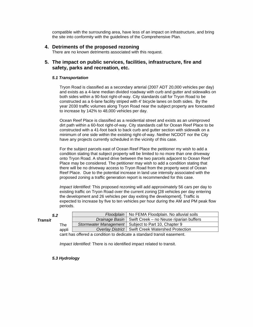
Tryon Road is classified as a secondary arterial (2007 ADT 20,000 vehicles per day) and exists as a 4-lane median divided roadway with curb and gutter and sidewalks on both sides within a 90-foot right-of-way. City standards call for Tryon Road to be constructed as a 6-lane facility striped with 4' bicycle lanes on both sides. By the year 2030 traffic volumes along Tryon Road near the subject property are forecasted to increase by 142% to 48,000 vehicles per day. Ocean Reef Place is classified as a residential street and exists as an unimproved dirt path within a 60-foot right-of-way. City standards call for Ocean Reef Place to be constructed with a 41-foot back to back curb and gutter section with sidewalk on a minimum of one side within the existing right-of-way. Neither NCDOT nor the City have any projects currently scheduled in the vicinity of this case. For the subject parcels east of Ocean Reef Place the petitioner my wish to add a condition stating that subject property will be limited to no more than one driveway onto Tryon Road. A shared drive between the two parcels adjacent to Ocean Reef Place may be considered. The petitioner may wish to add a condition stating that there will be no driveway access to Tryon Road from the property west of Ocean Reef Place. Due to the potential increase in land use intensity associated with the proposed zoning a traffic generation report is recommended for this case. Impact Identified: This proposed rezoning will add approximately 56 cars per day to existing traffic on Tryon Road over the current zoning [28 vehicles per day entering the development and 26 vehicles per day exiting the development]. Traffic is expected to increase by five to ten vehicles per hour during the AM and PM peak flow periods.
5.2 Transit
The applicant has offered a condition to dedicate a standard transit easement.
Impact Identified: There is no identified impact related to transit.
5.3 Hydrology
Floodplain No FEMA Floodplain. No alluvial soils Drainage Basin Swift Creek – no Neuse riparian buffers
Stormwater Management Subject to Part 10, Chapter 9 Overlay District Swift Creek Watershed Protection
Impact Identified: There is no identified impact related to hydrology.
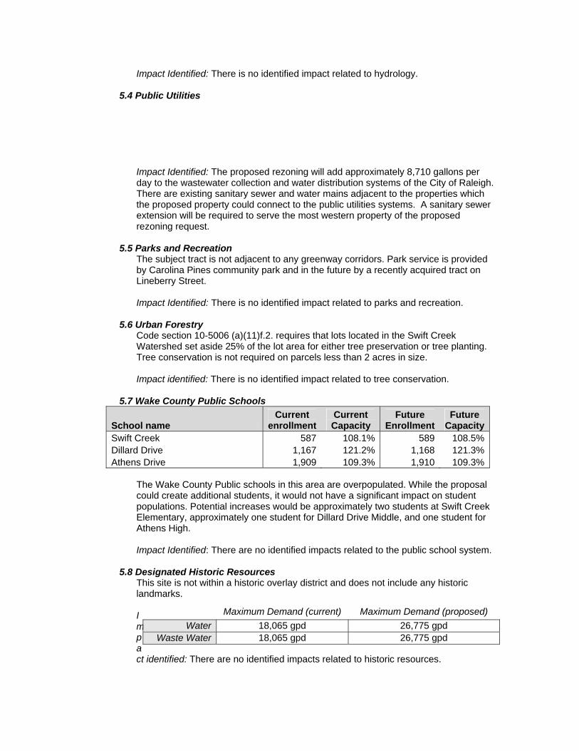
5.4 Public Utilities
Impact Identified: The proposed rezoning will add approximately 8,710 gallons per day to the wastewater collection and water distribution systems of the City of Raleigh. There are existing sanitary sewer and water mains adjacent to the properties which the proposed property could connect to the public utilities systems. A sanitary sewer extension will be required to serve the most western property of the proposed rezoning request.
5.5 Parks and Recreation
The subject tract is not adjacent to any greenway corridors. Park service is provided by Carolina Pines community park and in the future by a recently acquired tract on Lineberry Street. Impact Identified: There is no identified impact related to parks and recreation.
5.6 Urban Forestry Code section 10-5006 (a)(11)f.2. requires that lots located in the Swift Creek Watershed set aside 25% of the lot area for either tree preservation or tree planting. Tree conservation is not required on parcels less than 2 acres in size. Impact identified: There is no identified impact related to tree conservation.
5.7 Wake County Public Schools
School name Current
enrollmentCurrent Capacity
Future Enrollment
Future Capacity
Swift Creek 587 108.1% 589 108.5%Dillard Drive 1,167 121.2% 1,168 121.3%Athens Drive 1,909 109.3% 1,910 109.3%
The Wake County Public schools in this area are overpopulated. While the proposal could create additional students, it would not have a significant impact on student populations. Potential increases would be approximately two students at Swift Creek Elementary, approximately one student for Dillard Drive Middle, and one student for Athens High. Impact Identified: There are no identified impacts related to the public school system.
5.8 Designated Historic Resources This site is not within a historic overlay district and does not include any historic landmarks. Impact identified: There are no identified impacts related to historic resources.
Maximum Demand (current) Maximum Demand (proposed) Water 18,065 gpd 26,775 gpd
Waste Water 18,065 gpd 26,775 gpd
5.9 Impacts Summary There is very little impact on surrounding infrastructure associated with this case.
5.10 Mitigation of Impacts All impacts and issues have been addressed by the applicant.
6. Appearance Commission This proposal is not subject to review by the Appearance Commission.
7. Conclusions The request to rezone the property to Residential-15 Conditional Use is consistent with the relevant Comprehensive Plan policies and the future land use map. This site falls within an area designated as being appropriate for Moderate Density Residential. The applicant has offered to condition the property to 14 dwelling units per acre which would fall within the range of Moderate Density. The proposal also helps to create an appropriate transition from the higher density uses on the north side, to the low density residential to the south. The proposal would also be compatible with surrounding land uses and zoning. Several impacts were identified and then subsequently addressed by the applicant with revised zoning conditions. Conditions were added to mitigate impacts associated with transportation and transit, and the applicant has amended the request and will retain the Watershed Protection Overlay District.
R-10
RR
AP
CUD TD
NB
CMCUD R-10
CUD NB
CUD CM
O&I-1
CUD R-6
CUD R-4
R-4
TRYON
I 40
TRA
ILW
OO
D
LINEBERRY
MID
PIN
ES
WO
LFTE
CH
ALP
HA
ISABELLA
MIMS
BINN
S
NET
WO
RK
OC
EAN R
EEF
CEN
TEN
NIA
L R
IDG
E
GORMAN ST TO I 40
VERSATILE
RAYM
OND
SM
ITH TR
YON
GR
OVE
ENSONFI
ELD
HO
USE
PAUL
S PE
NNY
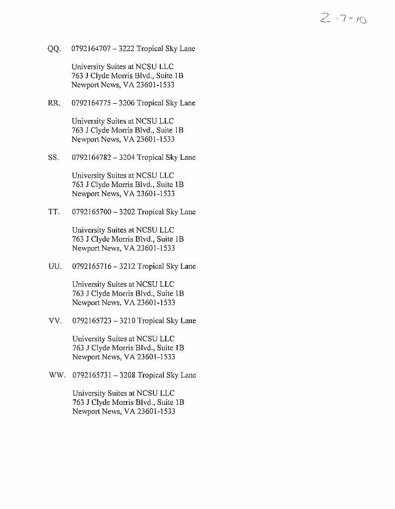
UNIVERSITY SUITES
WO
LFM
ILL
PROVOST
PARDUE WOODS
MANGO KEY
NINA
GOLDEN OAK
DO
LPH
IN K
EYBANANA KEY
PARADISE KEY
Existing Land UseMap
Z-7-10
NB, O&I-1, and R-10 w/
WPOD
to
R-15 CUD
3.4 acres
CITY OF RALEIGH
270Feet
Public HearingApril 20, 2010
(August 18, 2010)
SHOD-1
SHOD-1
WPOD
WPOD
R-10
R-10
WPOD
SHOD-1


![Polk County News. (Tryon, NC) 1920-08-06 [p ].newspapers.digitalnc.org/lccn/sn94058241/1920-08-06/ed-1/seq-6.pdf · THE TRYON NEWS, TRYON, N. 0. No Cussing Wanted from Outtftnden](https://img.pdfslide.net/doc/110x75/5f5c7cfcdac7055e127295f9/polk-county-news-tryon-nc-1920-08-06-p-the-tryon-news-tryon-n-0-no-cussing.jpg)


![Plano de Mídia [CIADOPE] TRYON](https://img.pdfslide.net/doc/110x75/568c4c271a28ab49169f02f1/plano-de-midia-ciadope-tryon.jpg)