Embed Size (px)
Citation preview

Zeus – Perseus -Vredefort Dome 765kv
Extended Bird Impact Assessment Study
Prepared by:
Chris van Rooyen Endangered Wildlife Trust
Private Bag X11 Parkview
2122 www.ewt.org.za
Prepared for: PBA International (SA) Pty. Ltd.
Engineering & Environmental Consultants
OCTOBER 2007
Zeus - Perseus/Zeus- Mercury 765kV: Bird Impact Assessment Study
2 of 20
TABLE OF CONTENTS Page
1 Introduction...........................................................................................................3
2 Background and brief ..............................................................................................3
3 Study area.............................................................................................................3
4 Study Approach ......................................................................................................6
5 Evaluation of alignments..........................................................................................7
6 Particulars of line design........................................................................................ 14
7 Nature of expected impacts.................................................................................... 14
8 Impact description, assessment and mitigation ......................................................... 16
9 References ......................................................................................................... 19

Zeus - Perseus/Zeus- Mercury 765kV: Bird Impact Assessment Study
3 of 20
1 Introduction
An EIA was undertaken for the construction of a single 765kV transmission power line between Zeus substation in Mpumalanga Province and Mercury substation in the Free State Province. During the EIA study process, a number of concerns were raised by landowners and the Dome Meteorite Park Association regarding the alignment of the proposed power line near the Vredefort Dome World Heritage Site (WHS) and across certain properties. Due to the above-mentioned concerns, an extended Visual Impact study of the three alignments to the west of the Vredefort Dome WHS was undertaken. The three alignments are the central alignment that runs parallel to the existing 400kV transmission power line; the eastern alignment that is the alignment closest to the Vredefort Dome and the western alignment that runs the furtherest west of the Vredefort Dome WHS. The FEIR submitted to DEAT in July 2006 recommended the eastern alignment as the preferred alignment because overall the ecological, avifauna and archaeological impact on any of the alternatives were seen to be low and could be mitigated in all cases. From a heritage perspective, the visual impact of the proposed transmission line from the core area of the WHS was seen to be too distant to have a significant impact and the impact of the eastern alignment was seen to be reduced due by its location in the valley. The socio-economic impact of the eastern alignment was seen to be lower than the western alignment that is moving closer to the outskirts of Potchefstroom and an area of higher population density. The RoD awarded by DEAT included the recommendation that the western alignment be used for the proposed transmission power line. Based on this, a number of appeals were received by DEAT to this decision and it was decided in conjunction with DEAT that an extended study of the three alignments by all the specialists, including the avifaunal specialists, be undertaken to attend to the appeals as well as resolve the impasse with regard to the alignment to be finally used for the transmission power line. 2 Background and brief
The terms of reference for the study are as follows:
• To establish which of the alignments is both technically feasible and environmentally the least damaging to avifauna in the area.
• Habitat transformation: The potential for negative impacts on the habitat through the construction of the power line to investigated and appropriate mitigation measures put forward.
• Disturbance: The potential for disturbance of birds during the construction and operation of the proposed transmission line to be investigated and mitigation measures put forward.
• The identification of any areas that may be considered ‘no-go’ areas from an avifaunal perspective and bird sensitive areas.
• Mapping of all relevant aspects. In the course of the study, the brief was elaborated and expanded upon as and when necessary. 3 Study area
See figure 1 below for a map of study area

Zeus - Perseus/Zeus- Mercury 765kV: Bird Impact Assessment Study
4 of 20
Figure 1: Study area showing the different alternatives
3.1 Description of vegetation types The total study area comprises 3 quarter degree squares (1:50 000 map units) which are divided as follows in vegetation types: Table 1: Vegetation types represented in the study area (Harrison et.al. 1997) Vegetation types 2627CA 2627CB 2627CC
Sour grassland 54% 80% 51% Mixed grassland 46% 20% 51%
As can be seen from the above table, the entire study area encompasses the grassland biome. The analysis will therefore concentrate on the grassland biome as all of the alignments are situated in this biome. It is widely accepted within the ornithological community that vegetation structure, rather than the actual plant species, influences bird species distribution and abundance (in Harrison et al 1997). Therefore, the vegetation description below does not focus on lists of plant species, but rather on factors which are relevant to bird distribution. The description makes extensive use of the work of Harrison et al (1997). In addition to the vegetation description, the micro habitats available to birds in the study area are described.
The dominant plants in the grassland biome are grass species, with geophytes and herbs also well represented (Low & Rebelo 1996). Grasslands are maintained mainly by a combination of the following factors: relatively high summer rainfall; frequent fires; frost and grazing. These factors generally preclude the growth of trees and shrubs. This biome has been largely

Zeus - Perseus/Zeus- Mercury 765kV: Bird Impact Assessment Study
5 of 20
transformed through various land uses such as afforestation and crop cultivation. This is particularly true in this study area where large scale cultivation of crops takes place. Sweet grassland is generally found in the lower rainfall areas. Vegetation is taller and sparser, and nutrients are retained in the leaves during winter. Relatively few bird species favour sweet grassland over sour or mixed grassland. Sour grassland generally occurs in the higher rainfall areas on leached soils. Vegetation is shorter and denser, and nutrients are withdrawn from the leaves during the winter months. Many grassland bird species show a preference for sour grassland over sweet or mixed. Mixed grassland is a combination or a transition between the two grassland types above. Whilst much of the distribution and abundance of the bird species in the study area can be explained by the description of vegetation types above, it is even more important to examine the micro habitats available to birds. These are generally evident at a much smaller spatial scale than the vegetation types, and are determined by a host of factors such as vegetation type, topography, land use and man made infrastructure. The micro habitats observed in this study area during the field visit are described below. Examples of each micro habitat can be seen in APPENDIX A.
• Riparian: This consists of thornveld or bushveld, along the edge of a watercourse or wetland especially along the Rooikraalspruit in this study area. From a power line bird impact perspective, this habitat is less important as it mostly benefit smaller woodland species which are not affected by the proposed power line.
• Wetlands and earth dams: Few significant wetlands or dams were recorded during the
field visit. One exception is a large dam is situated right next to western alignment 2 in the east where it branches off from the central alignment. A smallish wetland is formed by the Rooikraalspruit on the farm Spruite 456. A few small earth dams were recorded during the field visit. With the exception of the large dam next to western alignment 2, none of these wetlands and dams should attract significant Red Data species. It must be noted that a number of Red Data waterbirds were recorded in 2627CB by the southern African Bird Atlas Project. These include both species of pelican, both species of flamingo, Yellow-billed Stork, Black Stork and Caspian Tern. These birds could conceivably use the dam situated next to western alignment 2 when it is full, but are more likely associated with a huge dam further north outside the study area.
Rivers: The only drainage line of some significance recorded during the field visit was
the Rooikraalspruit. It runs through hugely transformed habitat and probably acts as a conduit for waterbirds between water bodies. It is unlikely that it will be attractive for any of the Red Data species recorded in the study area.
• Grassland: Small areas of grassland remain within the study area, albeit hugely
fragmented by intense crop cultivation. These patches of grassland are the most important habitat in the study area from a bird point of view and that is where most of the remaining large terrestrial species are likely to be found, such as Blue Cranes, White Storks and Secretarybirds.
• Exotic stands: These are stands of predominantly Eucalyptus species, presumably
originally planted as windbreaks. They may be significant for birds in terms of roosting or nesting as few indigenous tall trees exist in the landscape. However, they do not represent an important micro-habitat in the context of this study.
• Arable land: This comprises most of the study area. Since the different crop types in
their different stages can represent very different bird habitats, arable land is discussed in sub categories below:
Zeus - Perseus/Zeus- Mercury 765kV: Bird Impact Assessment Study
6 of 20
Maize: The predominant land use in the study area. When past the seedling stage, they are of little importance to most birds until harvested. In the context of this study, maize lands are not an important habitat.
Fallow land: All arable land, whatever the usual crop, must at some time lie fallow. This relatively bare ground can attract certain species if old seed or weeds are present. Fallow land has some value for species such as Black-headed Heron, Spur-winged Goose and Secretarybirds.
Newly ploughed land: Although simply bare soil, this habitat can represent an important feeding area to many birds, as old seed, weeds and insects abound. In this study area, this type of habitat could be utilised by Blue Cranes.
Irrigated pastures: Although not in much evidence in the study area, this is an important habitat for birds such as White Storks, and could on occasion also attract Blue Cranes. Some irrigated land exists in the study area which are highly attractive to birds, particularly in this dry landscape, and in particular the White Stork and Abdim’s Stork.
4 Study Approach 4.1 Sources of information The study made use of the following data sources:
• Bird distribution data of the Southern African Bird Atlas Project (SABAP – Harrison, Allan, Underhill, Herremans, Tree, Parker and Brown, 1997) obtained from the Avian Demography Unit of the University of Cape Town, in order to ascertain which species occur in the study area. A separate data set was obtained for each quarter degree square within the study area (marginal overlaps were discounted).
• Data from the Co-ordinated Avifaunal Road count project (CAR – Young, Harrison, Navarro, Anderson and Colahan, 1997) for the North-western Free State precincts (Young, Harrison, Navarro, Anderson and Colahan, 2003). This data was of particular importance in order to establish what densities of large terrestrial birds could be expected to occur in the study area, and especially what the habitat preferences of those species are.
• The conservation status of all bird species occurring in the aforementioned degree squares was determined with the use of The Eskom Red Data book of birds of South Africa, Lesotho and Swaziland (Barnes, 2000).
• The power line bird mortality incident database of the Eskom-Endangered Wildlife Trust Strategic Partnership (1996 to present) was consulted to determine which of the species occurring in the study area are typically impacted upon by power lines.
• A classification of the vegetation types in each quarter degree square was obtained from the Southern African Bird Atlas Project (Harrison, Allan, Underhill, Herremans, Tree, Parker and Brown (1997).
• Information on the micro-habitat level was obtained through visiting the area in a vehicle.
• Several landowners were interviewed with regard to the birds occurring on their properties.
• Satellite imagery from Google Earth was used to identify specific landscape features.
Zeus - Perseus/Zeus- Mercury 765kV: Bird Impact Assessment Study
7 of 20
4.2 Limitations & assumptions This study made the assumption that the above sources of information are reliable. The following factors may potentially detract from the accuracy of the predicted results:
• The SABAP data covers the period 1986-1997, which means that some of the data is now more than a decade old. Bird distribution patterns fluctuate continuously according to availability of food and nesting substrate.
• Sources of error in the SABAP database, particularly inadequate coverage of some quarter degree squares. This means that the report rates of species may not be an accurate reflection of true densities in quarter degree squares that were sparsely covered (for a full discussion of potential inaccuracies in ASAB data, see Harrison, Allan, Underhill, Herremans, Tree, Parker and Brown, 1997).
• The data on habitat use obtained from the CAR Project does not necessarily reflect the actual distribution of habitat types in the area for example observations may have been biased towards those habitats that happen to have been located next to routes.
• Predictions in this study are based on experience of these and similar species in different parts of South Africa. Bird interactions with power lines cannot be reduced to formulas that will hold true under all circumstances; at most impacts can be predicted with a fair amount of confidence based on field experience.
5 Evaluation of alignments
5.1 Significance of the study area for power line sensitive large terrestrial species from a
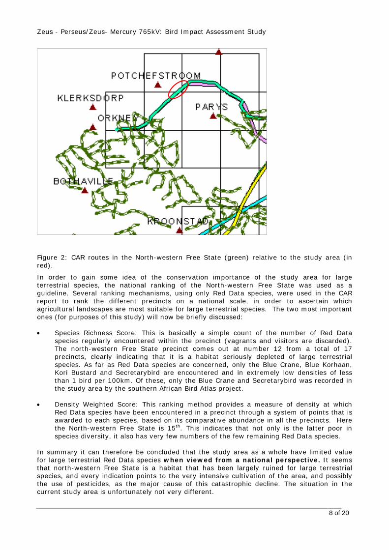
national perspective It is necessary to provide a broader perspective on the study area in order to gain some understanding of the importance of the potential bird impacts on a national scale. What needs to be established is the relative importance of the study area for power line sensitive species, especially Red Data ones, as this will have a bearing both on the expected frequency of the impacts and the significance of those impacts. In this respect the information gathered by the Co-ordinated Avi-faunal Road count project (CAR) is of vital importance.
The study area does not overlap directly with any CAR precincts (a precinct comprises a series of routes of 50-80km long on quiet public roads in farmlands), but is situated close to and in very similar habitat to the North-western Free State. The precincts in the latter yields vital clues as to the habitat preferences of several large, power line sensitive terrestrial species.
Zeus - Perseus/Zeus- Mercury 765kV: Bird Impact Assessment Study
8 of 20
Figure 2: CAR routes in the North-western Free State (green) relative to the study area (in red).
In order to gain some idea of the conservation importance of the study area for large terrestrial species, the national ranking of the North-western Free State was used as a guideline. Several ranking mechanisms, using only Red Data species, were used in the CAR report to rank the different precincts on a national scale, in order to ascertain which agricultural landscapes are most suitable for large terrestrial species. The two most important ones (for purposes of this study) will now be briefly discussed:
• Species Richness Score: This is basically a simple count of the number of Red Data
species regularly encountered within the precinct (vagrants and visitors are discarded). The north-western Free State precinct comes out at number 12 from a total of 17 precincts, clearly indicating that it is a habitat seriously depleted of large terrestrial species. As far as Red Data species are concerned, only the Blue Crane, Blue Korhaan, Kori Bustard and Secretarybird are encountered and in extremely low densities of less than 1 bird per 100km. Of these, only the Blue Crane and Secretarybird was recorded in the study area by the southern African Bird Atlas project.
• Density Weighted Score: This ranking method provides a measure of density at which
Red Data species have been encountered in a precinct through a system of points that is awarded to each species, based on its comparative abundance in all the precincts. Here the North-western Free State is 15th. This indicates that not only is the latter poor in species diversity, it also has very few numbers of the few remaining Red Data species.
In summary it can therefore be concluded that the study area as a whole have limited value for large terrestrial Red Data species when viewed from a national perspective. It seems that north-western Free State is a habitat that has been largely ruined for large terrestrial species, and every indication points to the very intensive cultivation of the area, and possibly the use of pesticides, as the major cause of this catastrophic decline. The situation in the current study area is unfortunately not very different.

Zeus - Perseus/Zeus- Mercury 765kV: Bird Impact Assessment Study
9 of 20
5.2 Power line sensitive species occurring in the study area A total of 17 power line sensitive Red Data species and two species protected under the Bonn Convention on Migratory Species have been recorded in the quarter degree squares that are bisected by the various alignments. The table that follows give a summary of expected impacts, habitat requirements and the reporting rates.

Table 2: Power line sensitive Red Data species occurring in the study area Abbreviations: B=Bonn Convention C=Critically Endangered E=Endangered NT=Near threatened V=Vulnerable CO=Collision HD=Habitat destruction D=Disturbance
Common Name Cons Status
Potential impact
Habitat Reporting rates in %
CO HD D
White Stork B
x Most common in wetlands in natural veld, but also in irrigated fields. CAR densities of >2/100km in the north-west Free State. Regularly collides with power lines.
2627ca:16 2627cb: 4 2627cc: 16
Abdim's Stork B
x Most common in natural veld and lucerne fields. CAR recorded very low densities (<1/100km) in the north-west Free State. Regularly collides with power lines.
2627ca: 22 2627cb: 3 2627cc: 20
White Pelican NT
x Very low reporting rates of just over 2%. Not likely to be encountered in the study area. Regularly collides with power lines.
2627ca: 0 2627cb: 1 2627cc: 0
Black Stork NT
x Mostly found at wetlands, rivers and dams in natural grassland. Very low report rates, unlikely to be found in the study area.
2627ca: 3 2627cb: 1 2627cc: 0
Yellowbilled Stork NT
x The species could be encountered at any sizable wetland or dam. The only likely place in the study area would be the large dam situated right next to western alignment 2 in the east where it branches off from the central alignment.
2627ca: 5 2627cb: 12 2627cc: 6
Greater Flamingo NT
x The species is nomadic and fly between suitable pans. The only likely place in the study area would be the large dam situated right next to western alignment 2 in the east where it branches off from the central alignment.
2627ca: 4 2627cb: 13 2627cc: 6

Zeus - Perseus/Zeus- Mercury 765kV: Bird Impact Assessment Study
Lesser Flamingo NT
x The species is nomadic and fly between suitable pans. The only likely place in the study area would be the large dam situated right next to western alignment 2 in the east where it branches off from the central alignment.
2627ca: 2 2627cb: 4 2627cc: 2
Secretarybird NT
x x x Widespread, particularly in the grassland areas, interactions could happen anywhere. Relatively high reporting rates. Regularly collides with power lines.
2627ca: 10 2627cb: 3 2627cc: 2
Peregrine Falcon NT
x Very low reporting rate of 2% in one square. Unsuitable habitat, no interactions expected.
2627ca: 0 2627cb: 0 2627cc: 2
Lanner Falcon NT
x Reasonably common (up to 11% reporting rate), could be encountered in almost any habitat. Some interactions could be expected, but generally not a high risk species.
2627ca: 12 2627cb: 0 2627cc: 4
Pinkbacked Pelican V
x Very low reporting rates (maximum 3%), but could be encountered on large open areas of water. The only likely place in the study area would be the large dam situated right next to western alignment 2 in the east where it branches off from the central alignment.
2627ca: 0 2627cb: 9 2627cc: 0
Whitebacked Vulture V
x Very low reporting rate (2%) could be encountered in the extreme west. Not at risk. Regularly collides with power lines.
2627ca: 1 2627cb: 0 2627cc: 0
Martial Eagle V
x Reported from the study area by a landowner. No serious risk envisaged. Collisions have been reported.
2627ca: 1 2627cb: 0 2627cc: 0
11 of 20

Zeus - Perseus/Zeus- Mercury 765kV: Bird Impact Assessment Study
African Marsh Harrier V
x x x No suitable habitat in the study area were recorded for this species during the field visit.
2627ca: 0 2627cb: 0 2627cc: 2
Blue Crane V
x X Highest risk in natural grassland, but bare lands also utilized. Definite risk of collisions. CAR reported very low densities in the western Free State (max.2/100km).
2627ca: 3 2627cb: 3 2627cc: 1
Grass Owl V
x x Could be encountered in any long, damp grass in the study area, even small patches between lands. At some risk of collision. Very low reporting rates.
2627ca: 6 2627cb: 3 2627cc: 1
12 of 20

5.3 Comparison of alignments One of the main objectives of this study is to arrive at a preferred alignment for the proposed power line. In order to arrive at a preferred alignment, the following factors were taken into account:
• The distance of line that bisects natural grassland. The reason why grassland was used as an indicator of sensitivity is because the vast majority of Red Data species prefers natural grassland to all other habitat types.
• The distance of line that runs parallel to an existing line. It is a proven fact that placing a new line next to an existing line reduces the risk of collisions to birds. The reasons for that are two-fold namely it creates a more visible obstacle to birds and the resident birds, particularly breeding adults, are used to an obstacle in that geographic location and have learnt to avoid it (APLIC 1994; Chundar & Choudhury 2005). Other transmission lines running parallel to the proposed alignments were therefore treated as a risk reducing factor.
• The number of significant wetlands and/or dams within 500m of an alignment. Wetlands and dams are great draw-cards for many birds, and generally acts as areas of high risk from a collision viewpoint.
5.3.1 Methodology The factors mentioned in 5.3 were incorporated into a formula to arrive at a risk rating for each corridor. The formula was designed as follows:
• Wetlands and dams: The length of alignment running within 500m of a dam or wetland was measured.
• The distance that the proposed alignments are directly parallel to other lines was measured.
• The length of alignment running parallel with or across natural grassland was measured in kilometres.
The results of measurements for the different alternatives are as follows:
Risk factor
Western alignment 2
Western alignment 1
Central alignment
Central alignment/alignment alternative 2/alignment alternative 4
Central alignment/alignment alternative 2/alignment alternative 3
Eastern alignment
Eastern alignment/ alignment alternative 1
Dams/wetlands 1.88 1 0.4Existing TX lines 6.49 1.42 22.8 16.43 Natural grassland 14.53 16.78 16.86 20.09 21.27 15.9 17.54
Obviously all these factors do not have an equal impact on the size of the risk, therefore a weighting was assigned to each factor, based on the author’s judgment on how important the factor is within the total equation. The following weights were assigned. Risk reducing factors were assigned a negative weight:
Risk weighting Dams/wetlands 5Existing TX lines -1Natural grassland 3
The final risk score for a factor was calculated as follows: measurements x weighting. The
final risk rating for an alignment was calculated as the sum the risk scores of the individual
factors:

Zeus - Perseus/Zeus- Mercury 765kV: Bird Impact Assessment Study
14 of 20
Alternatives Score Western alignment 2 46.5 Western alignment 1 48.92 Central alignment 27.78 Central alignment/alignment alternative 2/alignment alternative 4
43.84
Central alignment/alignment alternative 2/alignment alternative 3
63.81
Eastern alignment 52.7 Eastern alignment/alignment alternative 1
54.52
From the analysis it is clear that the central alignment seems to hold the least risk of bird interactions, and it is therefore recommended as the preferred alternative from a bird interaction perspective.
6 Particulars of line design
Cross-rope suspension towers will be used for the majority of the route. The tower is approximately 45 m high. The average span between towers will be about 450 m. Self-supporting strain towers will be used at bend points along the line. An 80m servitude is required to accommodate the towers on which the overhead line will be strung. The servitude is required to ensure safe construction, maintenance and operation of the line, and Eskom will be entitled to unrestricted access. The minimum vertical clearance between the lines and the ground is 10.4 m. Important aspects from a bird interaction perspective are the following:
• The design has no inherent electrocution risk for large birds because the clearances between live parts and live and earthed components exceed the wingspan of any bird.
• The structure stands 45 metres high at its highest point. The mid-span height of the earthwire will be about 36 metres. The earth wire will be the biggest risk from a bird interaction perspective. Birds in flight tend to see the bundled conductors, and then gain height to avoid them. In the process, the much thinner earth wire is not noticed and the birds may then collide with it (APLIC 1994).
• The design is such that bird streamers are unlikely to be a source of faulting on the line. Birds tend to perch on the highest points first, in this instance the earth peaks. The perching space above the conductors is uncomfortable and restricted. This type of tower has never had suspected bird streamer faulting (Eskom Transmission Engineering pers.comm). Furthermore, it is unlikely that a bird streamer would be able to bridge the air gap of 765kV line and cause a flashover, even on a strain tower, where the birds could perch.
7 Nature of expected impacts
Because of their size and prominence, electrical infrastructures constitute an important interface between wildlife and man. Negative interactions between wildlife and electricity structures take many forms, but two common problems in southern Africa are electrocution of birds (and other animals) and birds colliding with power lines. (Ledger and Annegarn 1981; Ledger 1983; Ledger 1984; Hobbs and Ledger 1986a; Hobbs and Ledger 1986b; Ledger, Hobbs and Smith, 1992; Verdoorn 1996; Kruger and Van Rooyen 1998; Van Rooyen 1998; Kruger 1999; Van Rooyen 1999; Van Rooyen 2000). Other problems are electrical faults caused by bird excreta when roosting or breeding on electricity infrastructure, (Van Rooyen

Zeus - Perseus/Zeus- Mercury 765kV: Bird Impact Assessment Study
15 of 20
and Taylor 1999) and disturbance and habitat destruction during construction and maintenance activities. 7.1.1 Electrocutions
Electrocution of birds on overhead lines is an emotional issue as well as an important cause of unnatural mortality of raptors and storks. It has attracted plenty of attention in Europe, USA and South Africa (APLIC 1994; van Rooyen and Ledger 1999). However, in the context of overhead lines above 132 kV, electrocutions are not a major issue. Electrocution refers to the scenario where a bird is perched or attempts to perch on the electrical structure and causes an electrical short circuit by physically bridging the air gap between live components and/or live and earthed components (van Rooyen 2004). Due to the large size of the clearances on most overhead lines of above 132kV, electrocutions are generally ruled out as even the largest birds cannot physically bridge the gap between dangerous components. In fact, transmission lines have proven to be beneficial to many birds, including species such as Martial Eagles, Tawny Eagles, African White-backed Vultures, and even occasionally Verreaux’s Eagles by providing safe nesting and roosting sites in areas where suitable natural alternatives are scarce (van Rooyen 2004). Cape Vultures have also taken to roosting on power lines in certain areas in large numbers, while Lappet-faced Vultures are known to using power lines as roosts, especially in areas where large trees are scarce (pers.obs.). 7.1.2 Collisions
Collisions are the biggest single threat posed by transmission lines to birds in southern Africa (van Rooyen 2004). Most heavily impacted upon are bustards, storks, cranes and various species of waterbirds. These species are mostly heavy-bodied birds with limited manoeuvrability, which makes it difficult for them to take the necessary evasive action to avoid colliding with power lines (van Rooyen 2004, Anderson 2001). In some localities, the mortality figures can be disturbing. In one instance, where bi-monthly monitoring took place, a single 10 km section of 132kV distribution line killed 59 Blue Cranes, 29 Ludwig’s Bustard, and 13 White Storks in a three year period (van Rooyen unpubl. data). In 2004, fifty-four Blue Crane carcasses were discovered near Graaf-Reinett in the Northern Cape province under 3.7km of distribution line. Data collected in the Northern Cape province between 1997 and 1999 provides further evidence of the potential gravity of the problem. During an initial clearing of transects, a total of 194 large bird carcasses were found under 40km of Transmission line (220 and 400kV) near De Aar in the Northern Cape. Subsequent monitoring of 140 km of power lines (transects of 10km each from 22kV up to 400kV) in the same area over a period of 12 months produced another 196 carcasses (mostly cranes and bustards) the majority under transmission lines (Anderson 2001).
The Red Data species vulnerable to power line collisions are generally long-lived, slow reproducing species under natural conditions. Some require very specific conditions for breeding, resulting in very few successful breeding attempts, or breeding might be restricted to very small areas. A good example of this is the two flamingo species that occur in southern Africa, which have experienced hardly any successful breeding attempts at Etosha Pan in Namibia for several decades. Another example is the Great White Pelican that only breeds successfully at Dassen Island in the Western Cape. These species have not evolved to cope with high adult mortality, with the results that consistent high adult mortality over an extensive period could have a serious effect on a population’s ability to sustain itself in the long or even medium term. Many of the anthropogenic threats to these species are non-discriminatory as far as age is concerned (e.g. habitat destruction, disturbance and power lines) and therefore contribute to adult mortality, and it is not known what the cumulative effect of these impacts could be over the long term.

Zeus - Perseus/Zeus- Mercury 765kV: Bird Impact Assessment Study
16 of 20
From the figures quoted above, it is clear that power lines are a major cause of avian mortality among power line sensitive species, especially Red Data species. Furthermore, the cumulative effects of power lines and other sources of unnatural mortality might only manifest itself decades later, when it might be too late to reverse the trend. It is therefore imperative to reduce any form of unnatural mortality in these species, regardless of how insignificant it might seem at the present moment in time.
7.1.3 Habitat destruction
During the construction phase and maintenance of power lines and substations, some habitat destruction and transformation inevitably takes place. This happens with the construction of access roads, the clearing of servitudes and the levelling of substation yards. Servitudes have to be cleared of excess vegetation at regular intervals in order to allow access to the line for maintenance, to prevent vegetation from intruding into the legally prescribed clearance gap between the ground and the conductors and to minimize the risk of fire under the line, which can result in electrical flashovers. These activities have an impact on birds breeding, foraging and roosting in or in close proximity of the servitude through modification of habitat.
7.1.4 Disturbance
Similarly, the above mentioned construction and maintenance activities impact on bird through disturbance, particularly during breeding activities. This could lead to breeding failure if the disturbance happens during a critical part of the breeding season. 8 Impact description, assessment and mitigation Plse see appendix B for an assessment of the impacts of the proposed alignments. It must be pointed out that any attempt at quantifying the potential bird impacts for the proposed development would entail the capturing of significant amounts of quantitive data, for example one would have to establish how many pairs of a given species are using a particular wetland and document the percentage of habitat loss that could occur if a transmission line is constructed in the wetland. Then the influence on the ability of the population to persist would have to be documented and quantified. Clearly such detailed studies fall outside the scope of this brief. The very fact that impacts such as habitat destruction and disturbance could be significant but difficult to quantify, means that all possible mitigation measures should be implemented on the basis of the pre-cautionary principle. Precaution – the “precautionary principle” or “precautionary approach” – is a response to uncertainty, in the face of risks to health or the environment. In general, it involves acting to avoid serious or irreversible potential harm, despite lack of scientific certainty as to the likelihood, magnitude, or causation of that harm. Precaution is now an established principle of environmental governance, prominent in law, policy and management instruments at international, regional and domestic level, across such diverse areas as pollution, toxic chemicals, food and phytosanitary standards, fisheries management, species introductions and wildlife trade. The immediate and obvious importance of precaution in the context of natural resource management and biodiversity conservation, where impacts can clearly be both serious and irreversible, has been recognised through its endorsement by all major biodiversity-related multilateral environmental agreements, as well as myriad policy and legislative instruments at all levels. The most significant impact that is foreseen is collisions with the earth wire of the proposed line. Quantifying this impact in terms of the likely number of birds that will be impacted, is very difficult because such a huge number of variables play a role in determining the risk, for example weather, rainfall, wind, age, flocking behaviour, power line height, light conditions, topography, population density and so forth. However, from detailed record keeping by the Endangered Wildlife Trust, it is possible to give a measure of what species are likely to be

Zeus - Perseus/Zeus- Mercury 765kV: Bird Impact Assessment Study
17 of 20
impacted upon, based on historical records. This only gives a measure of the general susceptibility of the species to power line collisions, and not an absolute measurement for this specific line. Research in the Netherlands has shown that spacing intervals have a major influence on the effectiveness of anti-collision devices (Koops & de Jong 1982, as cited in APLIC 1994). In South Africa, the same has been found (Anderson 2001). See figure 5 below for a suggested marking method with devices.
5 m 5 m
Device Device
Shield wire
Figure 3: Marking method with anti-collision devices on overhead ground wires (viewed from above). Note that both the wires shown above are the shield or ground wires (flappers staggered). There are several devices available in southern Africa for the marking of power lines. Some are dynamic devices (usually called bird flappers), and some are static. Both have advantages and disadvantages. Dynamic devices are very effective in reducing collisions as the birds seem to see them very well (van Rooyen unp. data); probably because of the movement that attracts attention. The disadvantage of dynamic devices is that they are subject to extensive wear and tear, inevitably limiting the lifespan of the device. This has obvious cost implications if a line needs to be re-marked at intervals of a few years. No solution to that problem has been found to date and it must be accepted as a constraint. Figure 4 show examples of bird flappers currently available on the market.
Figure 4: Examples of bird flappers
Static devices are mechanically more durable because they lack the element of wear and tear that moving parts inevitably have. However, in South Africa, static devices, particularly the so

Zeus - Perseus/Zeus- Mercury 765kV: Bird Impact Assessment Study
18 of 20
called Bird Flight Diverter (also known as the pigtail) has had limited success (Anderson 2001). The most obvious reason seems to be that they are simply less visible, especially the small ones (see figure 5). A better option would be to use the bigger pigtail (see figure 5, right), although it is still not the preferred option.
Small
Pigtails
Large pigtail
Figure 5: The overhead shield wires of a 66kV line marked with small pigtails. Research to find a compromise between durability and visibility is ongoing in South Africa. It is therefore recommended that the Endangered Wildlife Trust is consulted before a final decision is taken on the type of device to be used in this instance, as new products might be available by the time the line is constructed.

9 References Avian Power Line Interaction Committee (APLIC). 1994. Mitigating Bird Collisions with Power Lines: The State of the Art in 1994. Edison Electric Institute. Washington D.C.
Anderson, M.D. 2001. The effectiveness of two different marking devices to reduce large terrestrial bird collisions with overhead electricity cables in the eastern Karoo, South Africa. Draft report to Eskom Resources and Strategy Division. Johannesburg. South Africa.
Barnes, K.N. (ed.) 1998. The Important Bird Areas of southern Africa. BirdLife South Africa: Johannesburg.
Barnes, K.N. (ed.) 2000. The Eskom Red Data Book of Birds of South Africa, Lesotho and Swaziland. BirdLife South Africa: Johannesburg. Harrison, J.A., Allan, D.G., Underhill, L.G., Herremans, M., Tree, A.J., Parker, V and Brown, C.J. (eds). 1997. The atlas of southern African birds. Vol. 1&2. BirdLife South Africa: Johannesburg.
Hobbs, J.C.A. and Ledger J.A. 1986a. The Environmental Impact of Linear Developments; Power lines and Avifauna. (Third International Conference on Environmental Quality and Ecosystem Stability. Israel, June 1986).
Hobbs, J.C.A. and Ledger J.A. 1986b. “Power lines, Birdlife and the Golden Mean.” Fauna and Flora, 44, pp 23-27.
Kruger, R. and Van Rooyen, C.S. 1998. Evaluating the risk that existing power lines pose to large raptors by using risk assessment methodology: the Molopo Case Study. (5th World Conference on Birds of Prey and Owls: 4 - 8 August 1998. Midrand, South Africa.)
Kruger, R. 1999. Towards solving raptor electrocutions on Eskom Distribution Structures in South Africa. M. Phil. Mini-thesis. University of the Orange Free State. Bloemfontein. South Africa.
Ledger, J. 1983. Guidelines for Dealing with Bird Problems of Transmission Lines and Towers. Escom Test and Research Division Technical Note TRR/N83/005.
Ledger, J.A. and Annegarn H.J. 1981. “Electrocution Hazards to the Cape Vulture (Gyps coprotheres) in South Africa”. Biological Conservation, 20, pp15-24.
Ledger, J.A. 1984. “Engineering Solutions to the problem of Vulture Electrocutions on Electricity Towers.” The Certificated Engineer, 57, pp 92-95.
Ledger, J.A., J.C.A. Hobbs and Smith T.V. 1992. Avian Interactions with Utility Structures: Southern African Experiences. (Proceedings of the International Workshop on Avian Interactions with Utility Structures, Miami, Florida, 13-15 September 1992. Electric Power Research Institute.)
Low, A.B. & Rebelo, A.G. (Eds). 1996. Vegetation of South Africa, Lesotho and Swaziland. Department of Environmental Affairs and Tourism, Pretoria.
Sundar, K.S.G. & Choudhury, B.C. Mortality of sarus cranes (Grus antigone) due to electricity wiresin Uttar Pradesh, India. Environmental Conservation 32 (3): 260–269, 2005 Foundation for Environmental Conservation.

Zeus - Perseus/Zeus- Mercury 765kV: Bird Impact Assessment Study
20 of 20
Van Rooyen, C.S. and Ledger, J.A. 1999. “Birds and utility structures: Developments in southern Africa” in Ferrer, M. & G..F.M. Janns. (eds.) Birds and Power lines. Quercus: Madrid, Spain, pp 205-230
Van Rooyen, C.S. 1998. Raptor mortality on power lines in South Africa. (5th World Conference on Birds of Prey and Owls: 4 - 8 August 1998. Midrand, South Africa.)
Van Rooyen, C.S. 1999. An overview of the Eskom - EWT Strategic Partnership in South Africa. (EPRI Workshop on Avian Interactions with Utility Structures 2-3 December 1999, Charleston, South Carolina.)
Van Rooyen, C.S. 2000. “An overview of Vulture Electrocutions in South Africa.” Vulture News, 43, pp 5-22. Vulture Study Group: Johannesburg, South Africa.
Van Rooyen, C.S. 2003. Mitigation programme for Avian Collisions with Eskom Transmission Lines. Unpublished Progress Report, September 2003. Endangered Wildlife Trust, Johannesburg, South Africa.
Van Rooyen, C.S. 2004. The Management of Wildlife Interactions with overhead lines. In The fundamentals and practice of Overhead Line Maintenance (132kV and above), pp217-245. Eskom Technology, Services International, Johannesburg.
Van Rooyen, C.S. and Taylor, P.V. 1999. Bird Streamers as probable cause of electrocutions in South Africa. (EPRI Workshop on Avian Interactions with Utility Structures 2-3 December 1999. Charleston, South Carolina)
Verdoorn, G.H. 1996. Mortality of Cape Griffons Gyps coprotheres and African Whitebacked Vultures Pseudogyps africanus on 88kV and 132kV power lines in Western Transvaal, South Africa, and mitigation measures to prevent future problems. (2nd International Conference on Raptors: 2-5 October 1996. Urbino, Italy.)
Young, D.J., Harrison, J.A, Navarro, R.A., Anderson, M.A., and Colahan, B.D. (Eds). 2003. Big birds on farms: Mazda CAR Report 1993-2001. Avian Demography Unit: Cape Town.

Appendix A: Micro-habitat
Figure 1: Cultivated maize fields
Figure 2: A small wetland

Appendix A: Micro-habitat
Figure 3: Cultivated pastures
Figure 4: Old lands

Appendix A: Micro-habitat
Figure 5: Natural grassland
Figure 6: The Rooikraalspruit

Appendix B Assessment Tables Western Alignment 2 Pre-mitigation
Theme Bird collisions
Nature of impact Collision with overhead shield wires of the 765kV line Stage Construction and Decommissioning Operation
Extent of impact 0 4
Duration of impact 0 4
Magnitude 0 6
Probability of occurrence 0 4
Status of the impact 0 Negative
Level of significance 0 56
Mitigation measures 0 • Sections of line passing through natural grassland that pose a high collision risk must be identified during a “walk-through” and the earth wire on those sections should be fitted with anti-collision devices.
• The sections of line passing through or within 500 metres of wetlands/dams should be fitted with anti-collision devices on the earth wire.
EMP requirements Not applicable • After the final tower positions have been
established, a “walk-through” must be conducted by Eskom and the EWT to identify those sections of line that need to be marked with anti-collision devices.
• Regular monitoring of the line after construction to identify collision hot-spots.
Post-mitigation
Theme Bird collisions
Nature of impact Collision with overhead shield wires of the 765kV line Stage Construction and Decommissioning Operation
Extent of impact 0 4
Duration of impact 0 4
Magnitude 0 4
Probability of occurrence 0 3
Status of the impact 0 Negative
Level of significance 0 36

Appendix B Assessment Tables
Western Alignment 1 Pre-mitigation
Theme Bird collisions
Nature of impact Collision with overhead shield wires of the 765kV line Stage Construction and Decommissioning Operation
Extent of impact 0 2
Duration of impact 0 4
Magnitude 0 4
Probability of occurrence 0 3
Status of the impact 0 Negative
Level of significance 0 30
Mitigation measures 0 • Sections of line passing through natural grassland that pose a high collision risk must be identified during a “walk-through” and the earth wire on those sections should be fitted with anti-collision devices.
• The sections of line passing through or within 500 metres of wetlands/dams should be fitted with anti-collision devices on the earth wire.
EMP requirements Not applicable • After the final tower positions have been
established, a “walk-through” must be conducted by Eskom and the EWT to identify those sections of line that need to be marked with anti-collision devices.
• Regular monitoring of the line after construction to identify collision hot-spots.
Post-mitigation
Nature of impact Collision with overhead shield wires of the 765kV line Stage Construction and Decommissioning Operation
Extent of impact 0 2
Duration of impact 0 4
Magnitude 0 4
Probability of occurrence 0 2
Status of the impact 0 Negative
Level of significance 0 20

Appendix B Assessment Tables
Central Alignment Pre-mitigation
Theme Bird collisions
Nature of impact Collision with overhead shield wires of the 765kV line Stage Construction and Decommissioning Operation
Extent of impact 0 2
Duration of impact 0 4
Magnitude 0 4
Probability of occurrence 0 2
Status of the impact 0 Negative
Level of significance 0 20
Mitigation measures 0 • Sections of line passing through natural grassland that pose a high collision risk must be identified during a “walk-through” and the earth wire on those sections should be fitted with anti-collision devices.
• The sections of line passing through or within 500 metres of wetlands/dams should be fitted with anti-collision devices on the earth wire.
EMP requirements Not applicable • After the final tower positions have been
established, a “walk-through” must be conducted by Eskom and the EWT to identify those sections of line that need to be marked with anti-collision devices.
• Regular monitoring of the line after construction to identify collision hot-spots.
Post-mitigation
Nature of impact Collision with overhead shield wires of the 765kV line Stage Construction and Decommissioning Operation
Extent of impact 0 2
Duration of impact 0 4
Magnitude 0 4
Probability of occurrence 0 1
Status of the impact 0 Negative
Level of significance 0 10

Appendix B Assessment Tables
Eastern Alignment Pre-mitigation
Theme Bird collisions
Nature of impact Collision with overhead shield wires of the 765kV line Stage Construction and Decommissioning Operation
Extent of impact 0 2
Duration of impact 0 4
Magnitude 0 4
Probability of occurrence 0 3
Status of the impact 0 Negative
Level of significance 0 30
Mitigation measures 0 • Sections of line passing through natural grassland that pose a high collision risk must be identified during a “walk-through” and the earth wire on those sections should be fitted with anti-collision devices.
• The sections of line passing through or within 500 metres of wetlands/dams should be fitted with anti-collision devices on the earth wire.
EMP requirements Not applicable • After the final tower positions have been
established, a “walk-through” must be conducted by Eskom and the EWT to identify those sections of line that need to be marked with anti-collision devices.
• Regular monitoring of the line after construction to identify collision hot-spots.
Post-mitigation
Nature of impact Collision with overhead shield wires of the 765kV line Stage Construction and Decommissioning Operation
Extent of impact 0 2
Duration of impact 0 4
Magnitude 0 4
Probability of occurrence 0 2
Status of the impact 0 Negative
Level of significance 0 24

Appendix B Assessment Tables
Western Alignment 2 Pre-mitigation
Theme Disturbance
Nature of impact Disturbance of sensitive species during the construction phase of the 765kV lines Stage Construction and Decommissioning Operation
Extent of impact 1 0
Duration of impact 1 0
Magnitude 4 0
Probability of occurrence 3 0
Status of the impact Negative 0
Level of significance 18 0
Mitigation measures Construction activities must be restricted to the site and immediate surroundings. Construction camps must be placed away from sensitive habitat if possible (e.g. not in pristine grassland), and construction of access roads must be restricted to a minimum. Under no circumstances must access roads be constructed in wetlands. Nests must be reported to the Environmental Officer and the information relayed to the EWT. Trapping and hunting of wild birds by construction crews must be strictly forbidden.
EMP requirements None Not applicable
Post-mitigation
Nature of impact Disturbance of sensitive species during the construction phase of the 765kV lines Stage Construction and Decommissioning Operation
Extent of impact 1 None
Duration of impact 1 None
Magnitude 4 None
Probability of occurrence 2 None
Status of the impact Negative Not applicable
Level of significance 12 None

Appendix B Assessment Tables
Western Alignment 1 Pre-mitigation
Theme Disturbance
Nature of impact Disturbance of sensitive species during the construction phase of the 765kV lines Stage Construction and Decommissioning Operation
Extent of impact 1 0
Duration of impact 1 0
Magnitude 4 0
Probability of occurrence 3 0
Status of the impact Negative 0
Level of significance 18 0
Mitigation measures Construction activities must be restricted to the site and immediate surroundings. Construction camps must be placed away from sensitive habitat if possible (e.g. not in pristine grassland), and construction of access roads must be restricted to a minimum. Under no circumstances must access roads be constructed in wetlands. Nests must be reported to the Environmental Officer and the information relayed to the EWT. Trapping and hunting of wild birds by construction crews must be strictly forbidden.
EMP requirements None Not applicable
Post-mitigation
Nature of impact Disturbance of sensitive species during the construction phase of the 765kV lines Stage Construction and Decommissioning Operation
Extent of impact 1 None
Duration of impact 1 None
Magnitude 4 None
Probability of occurrence 2 None
Status of the impact Negative Not applicable
Level of significance 12 None

Appendix B Assessment Tables
Central Alignment Pre-mitigation
Theme Disturbance
Nature of impact Disturbance of sensitive species during the construction phase of the 765kV lines Stage Construction and Decommissioning Operation
Extent of impact 1 0
Duration of impact 1 0
Magnitude 4 0
Probability of occurrence 3 0
Status of the impact Negative 0
Level of significance 18 0
Mitigation measures Construction activities must be restricted to the site and immediate surroundings. Construction camps must be placed away from sensitive habitat if possible (e.g. not in pristine grassland), and construction of access roads must be restricted to a minimum. Under no circumstances must access roads be constructed in wetlands. Nests must be reported to the Environmental Officer and the information relayed to the EWT. Trapping and hunting of wild birds by construction crews must be strictly forbidden.
EMP requirements None Not applicable
Post-mitigation
Nature of impact Disturbance of sensitive species during the construction phase of the 765kV lines Stage Construction and Decommissioning Operation
Extent of impact 1 None
Duration of impact 1 None
Magnitude 4 None
Probability of occurrence 2 None
Status of the impact Negative Not applicable
Level of significance 12 None

Appendix B Assessment Tables
Eastern Alignment Pre-mitigation
Theme Disturbance
Nature of impact Disturbance of sensitive species during the construction phase of the 765kV lines Stage Construction and Decommissioning Operation
Extent of impact 1 0
Duration of impact 1 0
Magnitude 4 0
Probability of occurrence 3 0
Status of the impact Negative 0
Level of significance 18 0
Mitigation measures Construction activities must be restricted to the site and immediate surroundings. Construction camps must be placed away from sensitive habitat if possible (e.g. not in pristine grassland), and construction of access roads must be restricted to a minimum. Under no circumstances must access roads be constructed in wetlands. Nests must be reported to the Environmental Officer and the information relayed to the EWT. Trapping and hunting of wild birds by construction crews must be strictly forbidden.
EMP requirements None Not applicable
Post-mitigation
Nature of impact Disturbance of sensitive species during the construction phase of the 765kV lines Stage Construction and Decommissioning Operation
Extent of impact 1 None
Duration of impact 1 None
Magnitude 4 None
Probability of occurrence 2 None
Status of the impact Negative Not applicable
Level of significance 12 None

Appendix B Assessment Tables
Western Alignment 2 Pre-mitigation
Theme Habitat Destruction
Nature of impact Destruction of sensitive habitat during the construction phase of the 765kV lines Stage Construction and Decommissioning Operation
Extent of impact 1 None
Duration of impact 1 None
Magnitude 2 None
Probability of occurrence 3 None
Status of the impact Negative Not applicable
Level of significance 12 None
Mitigation measures Construction activities must be restricted to the site and immediate surroundings. Construction camps must be placed away from sensitive habitat if possible (e.g. not in natural grassland), and construction of access roads must be restricted to a minimum. Under no circumstances must access roads be constructed in wetlands. Special care must be taken not to destroy sensitive riparian vegetation.
None
EMP requirements None Not applicable
Post-mitigation
Extent of impact
1 None
Duration of impact
1 None
Intensity
1 None
Probability of occurrence
2 None
Status of the impact
Negative Not applicable
Level of significance
6 None

Appendix B Assessment Tables
Western Alignment 1 Pre-mitigation
Theme Habitat Destruction
Nature of impact Destruction of sensitive habitat during the construction phase of the 765kV lines Stage Construction and Decommissioning Operation
Extent of impact 1 None
Duration of impact 1 None
Magnitude 2 None
Probability of occurrence 3 None
Status of the impact Negative Not applicable
Level of significance 12 None
Mitigation measures Construction activities must be restricted to the site and immediate surroundings. Construction camps must be placed away from sensitive habitat if possible (e.g. not in natural grassland), and construction of access roads must be restricted to a minimum. Under no circumstances must access roads be constructed in wetlands. Special care must be taken not to destroy sensitive riparian vegetation.
None
EMP requirements None Not applicable
Post-mitigation
Extent of impact
1 None
Duration of impact
1 None
Intensity
1 None
Probability of occurrence
2 None
Status of the impact
Negative Not applicable
Level of significance
6 None

Appendix B Assessment Tables
Central Alignment Pre-mitigation
Theme Habitat Destruction
Nature of impact Destruction of sensitive habitat during the construction phase of the 765kV lines Stage Construction and Decommissioning Operation
Extent of impact 1 None
Duration of impact 1 None
Magnitude 2 None
Probability of occurrence 3 None
Status of the impact Negative Not applicable
Level of significance 12 None
Mitigation measures Construction activities must be restricted to the site and immediate surroundings. Construction camps must be placed away from sensitive habitat if possible (e.g. not in natural grassland), and construction of access roads must be restricted to a minimum. Under no circumstances must access roads be constructed in wetlands. Special care must be taken not to destroy sensitive riparian vegetation.
None
EMP requirements None Not applicable
Post-mitigation
Extent of impact
1 None
Duration of impact
1 None
Intensity
1 None
Probability of occurrence
2 None
Status of the impact
Negative Not applicable
Level of significance
6 None

Appendix B Assessment Tables
Eastern Alignment Pre-mitigation
Theme Habitat Destruction
Nature of impact Destruction of sensitive habitat during the construction phase of the 765kV lines Stage Construction and Decommissioning Operation
Extent of impact 1 None
Duration of impact 1 None
Magnitude 2 None
Probability of occurrence 3 None
Status of the impact Negative Not applicable
Level of significance 12 None
Mitigation measures Construction activities must be restricted to the site and immediate surroundings. Construction camps must be placed away from sensitive habitat if possible (e.g. not in natural grassland), and construction of access roads must be restricted to a minimum. Under no circumstances must access roads be constructed in wetlands. Special care must be taken not to destroy sensitive riparian vegetation.
None
EMP requirements None Not applicable
Post-mitigation
Extent of impact
1 None
Duration of impact
1 None
Intensity
1 None
Probability of occurrence
2 None
Status of the impact
Negative Not applicable
Level of significance
6 None

Appendix B Assessment Tables