Embed Size (px)
Citation preview
ZONAL DEVELOPMENT PLAN FORZONE P-1, NARELA
(NARELA SUB-CITY)
Approved by the Delhi Development Authority vide item no. 85/2007 dated 30.10.2007 for
inviting objections/suggestions
DELHI DEVELOPMENT AUTHORITY
Price :- Rs. 70/-
1
CONTENTSPage No.
1.0 Introduction 12.0 Statutory Provisions 13.0 Location, Boundaries and Area 24.0 Population, Employment and Work Force 55.0 Plan Provisions 56.0 Existing Profile 87.0 Objectives 98.0 Destination & Development Catalysts Targets 109.0 Proposals 1210.0 Land use Plan 1311.0 Proposed Change of Land-use 27
LIST OF DRAWINGS1.0 Location plan of Narela Sub-city (Zone P-1) 32.0 National Capital Territory of Delhi Zones (Division) 43.0 Zonal Development Plan4.0 Pocket wise details of specific landuse
LIST OF TABLES1.0 Proposed Land-use Break up 14
ANNEXURESANNEXURE-I Land use Break up as per approved 28
Zonal Plan of Sub Zone-I-1 (Narela Town)ANNEXURE-II Villages / Census Towns in Narala Subcity 29ANNEXURE-III List of unauthorized colony falling in 30
Narela Sub-cityANNEXURE-III-A List of unauthorized regularized colonies 31
(Tentative)ANNEXURE-IV Details of Facility Areas 32ANNEXURE-V List of village ponds – Alipur block 35ANNEXURE-VI Pockets wise details of specific landuses 36
as per zonal development plan and propo- sed modifications
ANNEXURE-VII Identification of streets for commercial use 39 in Narela Zone & Identification of comer-
cial streets in Narela Zone
ANNEXURE-VIII Identification of Mixed landuse street in 40 Narela Zone
2
PREAMBLE
In accordance with Authority’s Resolution in its
meeting held on 6.9.2007, genuine pre-existing
institutions, i.e. before 1.1.2006, rendering cultural,
religious (including spiritual) health care and
educational services to the people, but which do not
form part of the ridge or Gram Sabha or public land,
shall be incorporated vis-a-vis their current land uses
in the respective Zonal Plan-2021. Such institutions
will, however, be subject to reasonable policy and
procedural stipulations regarding factual verification,
FAR, Development Charges, Land-use, etc.
3
ZONAL PLAN OF ZONE P-1 ( NARELA SUB-CITY)
1.0 INTRODUCTION
1.1 The NCT of Delhi has been divided in 15 nos. of planning zones
(division) designated from ‘A’ to ‘P’ (except Zone-I) in the Master
Plan for Delhi-2021, P-Zone is further sub divided in to two zones
designated on P-1 & P-II zones. P-1 zone covers an area of
9866 hact.
1.2 As per MPD-2001 provisions, this zone covers Narela sub-city that
comprises of parts of Zones – M, N and P. It formed part of the
urban extension plan of MPD-2001 approved by the Authority vide
Resolution No. 79 dated 30.6.1987. Hereinafter this zonal plan is
referred to as Zonal Plan of Narela, Zone P-1. This zone has been
developing since pre-independence era and through the MPD-1962,
MPD-2001 and now MPD-2021. As the zone has a heterogeneous
character having the unplanned areas and planned areas
development norms of zonal plan.
2.0 STATUTORY PROVISIONS
2.1 Zonal Development Plan means a plan for a Zone (Division) of
the National Capital Territory of Delhi. The Zonal Plan (Divisional
Plan) details out the policy of the Master Plan and acts as a link
between the layout plan and the Master Plan. The Development
Schemes / lay out plan indicating use premises should conform to
the Master Plan / Zonal Plan.
1
2.2 The Zonal Plan of this area stands approved vide MOUD letter
no. K-13011/7/06/DDIB dt.26.052006. However, this has now been
reviewed under the framework of MPD-2021.
2.3 MPD-2021 stipulates that already approved sub-zonal plans in
conformity with master plan shall continue to be operative. The
proposed zonal plan after approval shall supersede the earlier
approved sub-zonal / zonal plans.
2.4 Section-8 of Delhi Development Act provides for preparation
of Zonal Development Plan simultaneous with the preparation of
Master Plan or as soon as may be, the Authority shall proceed with
the preparation of Zonal Development Plan for each of the zone into
which Delhi may be divided. However, a Zonal Development Plan
may contain a site plan and land use plan with approximate location
and extent of land uses such as public and semi-public buildings /
work centers / utilities, roads, housing recreation, industries,
business, markets, schools, hospitals, open spaces etc. It may also
specify standards of population density and various components of
development of the zones.
The procedure to be followed for the preparation and approval of the
Zonal Development Plan is laid down in Section – 10 of the Act.
3.0 LOCATION, BOUNDARIES AND AREA
3.1 P-1 zone is located in the North-West of NCTD & the
boundaries are as under :
North: NCTD Boundary
South: Boundaries of Sub-zones C and H
2
3
4
East: G. T. Karnal Road and its bypass (NH-1).
West: Western Yamuna Canal.
3.2 The total area of the zone is 9866 Hact. of which urbanisable
area of the zone is 7365 Hectares remaining 2501 Hectares is under
Rural / Green Belt towards Northern border of NCTD as per MPD-
2021 land use plan.
4.0 POPULATION AND WORK FORCE
4.1 Population - As per MPD-2021 the urban extension areas are
proposed to be planned with an overall city level density of 250
persons per hectare for urban extensions and based on the area
under consideration the proposed population is to 1.62 million
including that of the existing settlements.
4.2 Work Force - MPD-2021 has anticipated a participation rate
of 38.1% and thereby the work-force in the Narela Sub-city works-
out to about 6.2 lakh, due to the location of Industries in the sub-city,
the component of work force works out to be roughly 35-40 %, i.e. in
all a generation of about 6.0 lakh workers.
5.0 PLAN PROVISIONS
5.1 Master Plan for Delhi - 1962
The MPD-62 recommended to develop Narela as one of the ring
towns around Delhi Metropolitan Area (DMA) owing to its location
and development potential. It proposed a township for 60000 people
with government offices and industry to make the town a self
contained unit. The proposal included the adjoining developments of
Mamurpur village and the development undertaken by the Ministry of
5
Rehabilitation. Broadly the land use plan for 1753 acres was detailed
out with a gross residential density of 50-60 persons / acre. As per
the provisions of MPD-62 a Zonal Development Plan for Narela ring
Town / (Zone I-1) was prepared and approved by the Central
Government. Ministry of works and Housing vide letter No. 11-2/69-
UDI dated 10th January 1974. The land use break up as per
approved zonal plan of zone I-1 is annexed at annexure-1.
5.2 Master Plan for Delhi – 2001
As per MPD-2001, urban area was proposed to be extended about
18000 to 24000 ha. which includes Narela sub-city also.
Zonal Plan of Narela Subcity
Based on the MPD-2001 the zonal plan of this zone (comprising of
part zone M, N & P) covering an area of 9866 Hact. was approved
vide letter No. 13011/7/06/DDIB dated 26.05.2006. The salient
features of the approved zonal plan are:
3165 ha. of land earmarked for residential use to
accommodate 12 lakh population
For integration of goods movement by road and rail freight
complex is proposed this consist of wholesale market,
chemical market, ware housing, road (truck) and rail
transport terminal, ISBT etc.
To cater to the inter city passenger movement a
metropolitan passenger terminal is provided in the zonal
plan.
About 1500 ha. land in this zone has been developed in the
form of various housing category i.e. EWS, LIG, MIG &
6
SFS flats. Approx. 850 nos. of alternative plots for the land
owner where land is acquired. Relocation of slum & JJ
squatters from other parts of Delhi. Macro/Micro level
facilities such as hospital, water & sewerage pumping
station, cremation ground, convenient & local shopping
centre, development of roads and about 300 ha. of Indl.
Areas.
5.3 MPD-2021 provisions
MPD-2021 stipulates the holding capacity of the zone to be about 16.2 lakhs.
MPD 2021 has proposed a series of innovative concepts such as:
Local area planning, Redevelopment of villages, unauthorized
colonies and Built up areas, Restructuring around major transport
corridors, metro corridor, a network of green & sports infrastructure
etc. which will be suitably incorporated while preparing the detailed
schemes.
As far as the proposed Green Belt on the periphery of NCTD is
concerned, the plan will have to be developed in such a manner that
the villages/abadi falling in this belt can be suitably marked and
comprehensive rural development/agriculture development could be
planned in the surrounding areas.
5.4 NCR Plan-2021 Provisions
The Regional Plan for NCR-2021 notified in September, 2005
formulated a set of policies for the control of land uses and
development of infrastructure in the region. The Functional Plan on
Transport prepared and approved by the NCR Planning Board in
1996 envisages an organized transport network to improve
7
accessibility and the movement of goods and passengers within the
region. The Functional Plan of Transport has suggested the
proposals for construction of road and rail linkages along the high-
density routes in and around the Capital and also in the National
Capital Region. It is proposed to develop activities keeping in view
rail and road linkages with Delhi Metropolitan area and at the same
time relieving pressure on the existing transport routes converging at
Delhi.
Integrated Mass Rapid Transport System (MRTS), Regional
Rapid Transport System (RRTS), expressways, bypasses as
proposed in the NCR Plan-2021 need to be executed.
6.0 EXISTING PROFILE AND PHYSICAL CHARACTERSTICS
6.1 The zone P-1 is very well connected by major roads and highways &
ideally suited for the urban development. The entire zone area is a
vest expanse of more or less flat terrain with land gradually slopping
the south. The area has very large green tree coverage in the form
of orchards, forest (declared as reserved forest) and farmlands. The
sub-city area has good soil for construction. The whole of sub-city
has good natural drainage system and the area is divided into two
drainage basins (i) catchments of Bawana escape and (ii)
catchments of Drain No. 6. Both these drains have number of
subsidiaries spread over the entire sub-city area holding mainly the
rural discharge.
6.2 Other Characteristics:
The significant existing developments in the sub-city are as under:
8
i) The abadis of 16 villages and two census towns (Alipur and
Narela) fall in the zone. A list of the villages falling in the zone
with their population as per census of India 2001 is annexed
as Annexure-II.
ii) The large number of farmhouses exist in this area. A number
of unauthorized colonies and other developments have also
grown within the zone.
iii) The major portion of planned development taken up by DDA is
near the Narela Town. On acquired land of about 516 hact.
initially for various uses.
iv) The total area of 483 hact. has been identified for industrial
use zone out of which 247 hact. has already been developed
by DSIDC and is operational.
v) Land for utilities like water treatment plant, roads, ESS, part
integrated freight complex has been acquired and are being
developed.
vi) Integrated Freight Complex (IFC) covering an area of 397.81
hact. is a major economic and employment generation centre.
7.0 OBJECTIVES
The objectives of the zonal development plan are as under :-
i) As per MPD-2021 this area will be developed as an integrated
part of urban extension with self sufficient and high level of the
services.
9
ii) This area will cater to all sections of the society in term of
housing and employment.
iii) To provide a comprehensive framework of land/uses as
envisaged in the urban extension plan of MPD-2021.
iv) To retain the agricultural green belt as shown in the MPD-
2021 land-use plan.
8.0 DESTINATION & DEVELOPMENT CATALYSTS TARGETS
8.1 Destination Targets:
Narela Industrial Area
Bawana Industrial Area
Metropolitan Passenger Terminal (MPT)
Integrated Freight Complex (IFC)
Interstate Bus Terminal (ISBT)
District Center and community Centers, Food &
Craft Bazaar
District Sports Center
Integrated Schools, hospitals & Socio-cultural
Centers
International Exhibition Center/Trade Conference
Center
Hi-Tech Park
University Center for research, higher education
& colleges
8.2 Development Catalysts:
10
Construction of 100 m. UER-II, 80 m. UER-I & III
and 60 m. R/W roads for connectivity and opening of the area.
Extension of MRTS routes from Barwala to
Bawana and Holambi Kalan station.
Increase in the frequency of shuttle train service
between Delhi and Narela.
Introducing new routes and increasing frequency
of existing bus routes
Relocation of existing grain go-downs to the
designated warehousing at IFC
Relocation of Chemical Market and wholesale
markets in IFC.
Development of industrial areas.
The above would involve certain modifications in the already
approved zonal plan: -
1. To provide a University Center for higher education and
research.
2. To provide District Sport Centre and Divisional Sport Centre.
3. To provide an International Exhibition Fair ground along with
trade cum conference center
4. To explore possibilities of extending MRTS route up to the sub-
city.
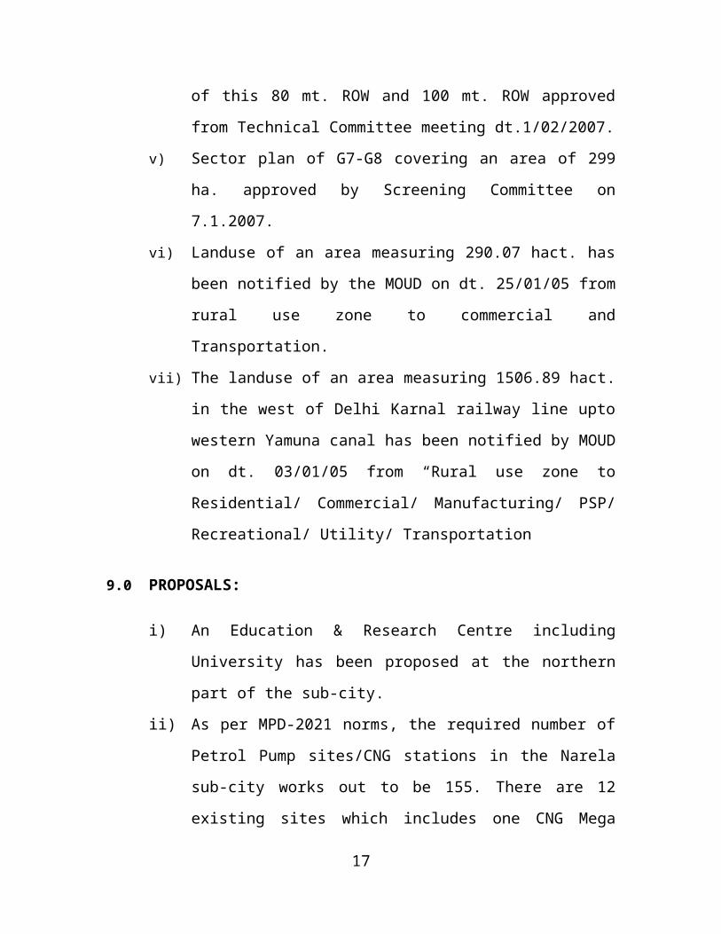
Following are the approved schemes in Narela Sub-city:
i) Sector Plan of A1-A4 for 320 hectares has been approved by
the Screening Committee as high value residential
11

development to be developed on group housing basis. The
above proposal was approved by the Screening Committee in
its meeting held in Oct.’2004 which has necessitated
relocation of Jail & court site, service center site and
readjustment of landuse in the zonal Plan of Narela Sub-city
as the land under 3 HT lines passing through this residential
sector which has been proposed as zonal green.
ii) For water treatment plant to be allotted to DJB. Tech.
Committee in its meeting held dt. 25.10.04 decided to earmark
35 hact. of land at Narela.
iii) An area of 175 hect. has been notified for “manufacturing” use
vide MOUD notification dt. 01.03.05 and DSIDC is developing
it.
iv) The realignment of 80 mt. Urban Extension Road-I (UER-I)
near FCI godown was approved by the Technical Committee
in its meeting held on 12/05/2004. Subsequently the details
alignment of this 80 mt. ROW and 100 mt. ROW approved
from Technical Committee meeting dt.1/02/2007.
v) Sector plan of G7-G8 covering an area of 299 ha. approved by
Screening Committee on 7.1.2007.
vi) Landuse of an area measuring 290.07 hact. has been notified
by the MOUD on dt. 25/01/05 from rural use zone to
commercial and Transportation.
vii) The landuse of an area measuring 1506.89 hact. in the west
of Delhi Karnal railway line upto western Yamuna canal has
been notified by MOUD on dt. 03/01/05 from “Rural use zone
to Residential/ Commercial/ Manufacturing/ PSP/
Recreational/ Utility/ Transportation
12
9.0 PROPOSALS:
i) An Education & Research Centre including University has
been proposed at the northern part of the sub-city.
ii) As per MPD-2021 norms, the required number of Petrol Pump
sites/CNG stations in the Narela sub-city works out to be 155.
There are 12 existing sites which includes one CNG Mega
station in Narela project, 6 of the existing sites are located on
GT Karnal Road (NH-1) near Singhu Border along the G.T.K.
Road, which are located in mandatory green belt need to be
dealt as per NCR Plan 2021 provision. The remaining sites
are proposed to be located at layout level as per prevailing
MPD / Guidelines.
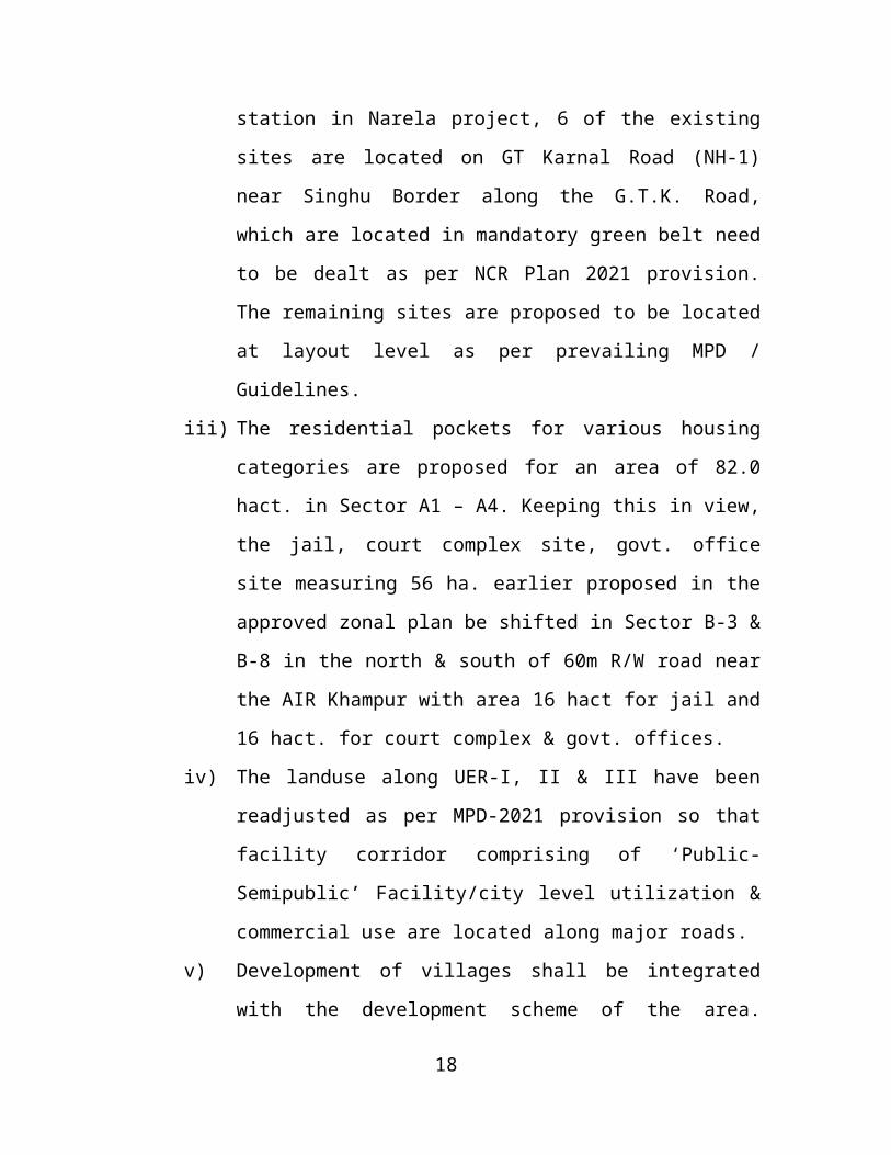
iii) The residential pockets for various housing categories are
proposed for an area of 82.0 hact. in Sector A1 – A4. Keeping
this in view, the jail, court complex site, govt. office site
measuring 56 ha. earlier proposed in the approved zonal plan
be shifted in Sector B-3 & B-8 in the north & south of 60m
R/W road near the AIR Khampur with area 16 hact for jail and
16 hact. for court complex & govt. offices.
iv) The landuse along UER-I, II & III have been readjusted as per
MPD-2021 provision so that facility corridor comprising of
‘Public-Semipublic’ Facility/city level utilization & commercial
use are located along major roads.
v) Development of villages shall be integrated with the
development scheme of the area. Around these settlements,
education, health and recreational facilities and other uses
would be developed for the benefit of the local population.
13
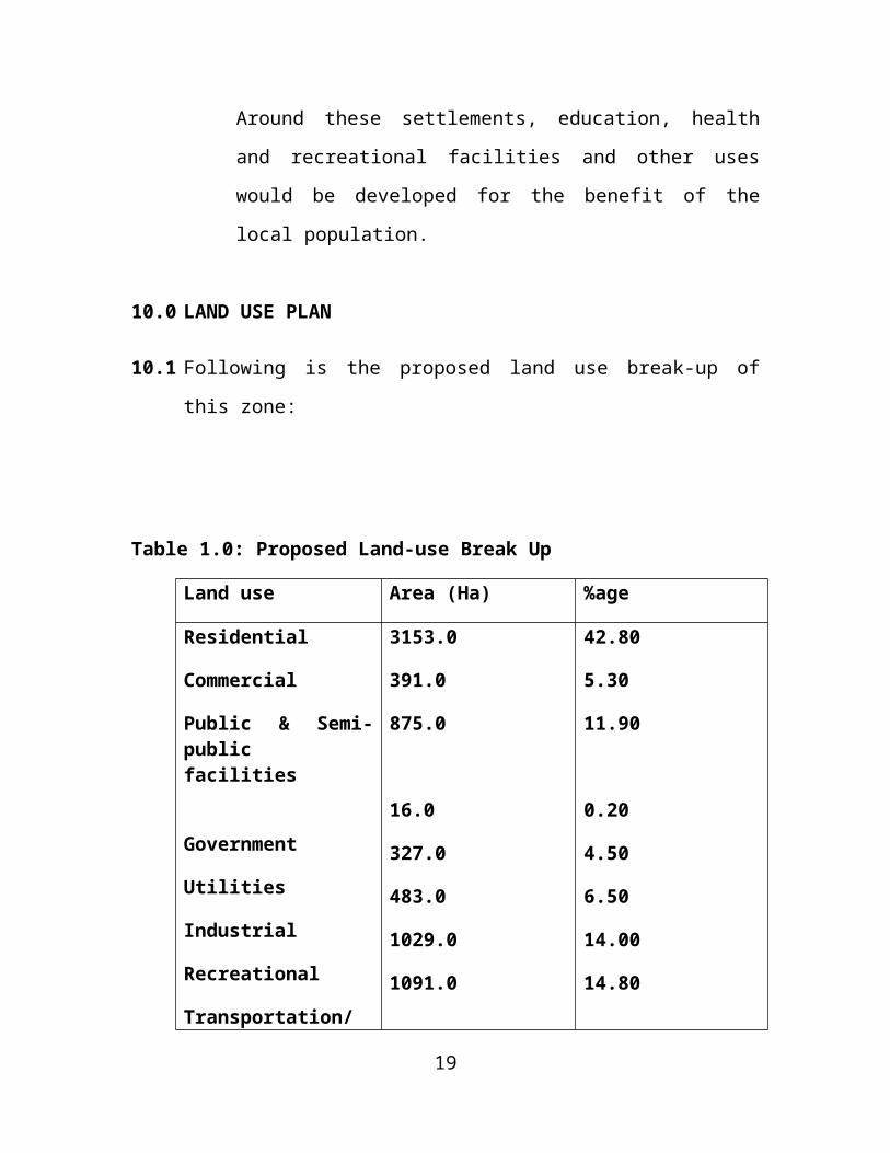
10.0 LAND USE PLAN
10.1 Following is the proposed land use break-up of this zone:
Table 1.0: Proposed Land-use Break Up
Land use Area (Ha) %age
Residential
Commercial
Public & Semi-public facilities
Government
Utilities
Industrial
Recreational
Transportation/ Circulation
3153.0
391.0
875.0
16.0
327.0
483.0
1029.0
1091.0
42.80
5.30
11.90
0.20
4.50
6.50
14.00
14.80
Total 7365.0 100.0
Note:
Area under “Recreational use” includes 242.4 Ha of AIR land (AIR Khampur + AIR Signals).
10.2 Residential Development
10.2.1 Existing Development
14
The residential development in Narela Sub-city has taken place so
far in the form of various types of DDA Housing i.e. EWS, LIG,
MIG /self financing. A new concept of incremental housing was also
adopted keeping in view of the growing needs of a family. Beside
this the unorganized growth of residential development has taken
placed in the form of unauthorized colonies, extension of villages
etc. The list of villages and unauthorized colonies/ unauthorized
regularized colonies is annexed at annexure II, III & IIIA respectively.
A large no. of slum and J.J. population has also been relocated from
the mother city. One pocket in sector B-2 has also been developed
as turn key project for LIG housing.
a) Existing villages & Census Town- The villages and census
towns are also considered at par with these as they also have
the same traits. The socio-economic changes in these old
unplanned areas, especially in villages have been substantial.
The redevelopments plans should ensure that the
permissibility of mixed use zoning at property or within the
premise level is compatible to the predominant residential
areas.
b) Unauthorised colonies – Unauthorised colonies in Delhi pose
a serious problem as a huge population is living in these
colonies.
The present method of regularization of unauthorized colonies
is by the provision of basic infrastructure to improve the
environment. However regularization has not really brought in
any tangible improvement. Effectively, the process has only
15
led to de-facto tenure rights on the land and access to
services.
In all unauthorized colonies whether on private or public land,
regularization should be done as per the govt. orders issued
from time to time. It must be ensured that for improvement of
physical and social infrastructure, the minimum necessary/
feasible level of services and community facilities are
provided.
10.2.2 New Housing Areas:
The proposed housing strategy incorporates approaches for
development of new housing area, upgradation and re-densification
through re-development of existing housing area including
unauthorized colonies, in view of the limited availability of land and
increased requirement of housing, plotted residential development
shall be discouraged. The sub-city when fully developed will provide
housing facilities to over 3.60 lakh families in all income groups.
Involvement of private sector in development of housing will be
considered as per MPD-2021 provision.
10.2.3 As per MPD-2021, the identification of mixed uses area / street shall
be done as per mixed use regulation. The mixed use would be
permissible on streets/stretches already notified by the competent
authority. The mixed use areas will be shown in the local area plans.
The list of commercial and mixed land-use streets in Narela zone as
per notification of GNCTD dated 15.9.07 & 12.4.2007 is annexed at
annexure – VII & VIII respectively. Keeping in view that the
development of Narela sub-city is yet to come up, MCD may
16
consider with taking forward the list of mixed use & commercial
streets.
10.3 Commercial
Shopping and commercial areas reflect the economy and the image
of the city. As required three District Centers has been proposed in
zone P-I and one remaining site under District Centers in IFC will be
utilized for sub-city level whole sale and service market.
The space for informal bazaar and service market will be reserved in
the District Centers, Community Centers and LSS/CSC. Integrated
Freight Complex (IFC) covering an area of 397.81 hact. is major
economic activity and employment generation centre.
10.4 Public and Semi-Public Facilities
The requirement of Public and Semi-public facilities (Social
Infrastructure) up to the Zonal Plan level have been identified and
located in various facility areas as per the norms. Each public and
semi-public facility pocket provides a cluster of various community
and above level facilities worked out as per the population of the
sub-zonal pockets. Some of the major facilities proposed as:
University Centre (1 Nos.), Medical College (2 Nos.), Divisional
Sports Centre (1 Nos.), District Sport Centre (3 Nos.), International
Exhibition cum Fair Ground (1 Nos.), District Jail (1 Nos.).
10.5 Government Offices
17

An integrated office complex has been proposed in Sector B-3
(16 ha.) which will comprises the offices of GNCTD, Local bodies
district court etc.
10.6 Utilities / Physical Infrastructure
10.6.1 Water Supply
The total water requirement of the sub-city works out to the
approximately 120 MGD @ 60 gallons capita per day as per MPD-
2021 norms. Water Treatment Plants with a capacity of 300 MGD
has been planned which would serve Rohini as well. The water
supply system will consist of underground reservoirs / command
tanks (each for 1.5 to 2 lakh population) inter-connected by water
mains. Each Command Tank will have its own command area. Land
for W.T.P. along Western Yamuna Canal has been identified and
transferred to D.J.B.
10.6.2 Sewerage System
Total Sewerage is expected to be generated as 90 MGD. Two STP’s
have been planned. STP-I with a capacity of 20 MGD and STP-II
with a capacity of 70 MGD system to consist of Gravity main sewage
pumping station and rising mains. The sewerage treatment plants
are towards the east of G.T. Karnal Road and are in the process of
development and would take care of requirement of Narela sub-city.
10.6.3 Storm water Drainage
Total discharge is of about 7000 cusecs. The total area falls under
the catchment of Bawana escape and Drain No. 6. Also there are
number of subsidiary drains such as Bakaner Drain, Sanoth Drain,
18
Gogha Drain etc which will form major network for carrying the storm
water.
10.6.4 Power
Total requirement: 1400 M.W.
System may consist of 400 KV ESS (1 No. existing) and 220 KV
ESS (5 Nos., 1 already existing) and 66 KV ESS (20 Nos.). The
detailed locations and numbers would be decided in consultation
with concerned agencies at the time of preparation of detail plan of
the sub-city.
10.6.5 Solid Waste Management
Total Solid Waste : 840 tons / day. The process of disposal to be
through Sanitary landfills, composting and incineration depending
upon the quality of the refuse. In future emphasis would be laid on
solid waste disposal by more scientific method, where the land
requirement gets reduced to minimum in consultation with the
concerned agencies.
A site of about 60 hact. for solid waste has been earmarked near
Narela - Bawana industrial area Ph-II.
There is a scope to improve the service delivery by proper
management and coordination. The local bodies and service
agencies may take into account the proposals of zonal plans for
making advance preparation for the provision of services in the
proposed Urban Extension. Alternatives, such as, public private
partnership / joint sector /SPV and privatization may also be
considered with the view to harness all the resources for making
19
available services in a time bound manner. Decentralization of
services, adoption of new technology and ecological concepts, such
as, watershed planning and better ground water management, zero-
run off drainage, roof top rain water harvesting, recycling, renewable
energy, leakage and waste minimization, etc should be the basis of
services planning and development.
10.7 Industry
An area of 483 Hect. has been proposed for industrial use which
consist of 3 industrial clusters namely (i) Narela Industrial Area in
Ph-1. (ii) Bawana Industrial Area Ph-II. (iii) Bhorgarh Industrial Area.
The planning & development of these industrial areas is dealt by
GNCTD. Besides these, two service centers have been proposed.
10.8 Recreational
10.8.1 About 1029 Hectare of land has been proposed for “Recreational’
use which comprises of community, district and sub-city level parks
and play grounds as per the provision of MPD-2021. Land under
forests, drains, HT lines have been proposed for ‘Recreational’ uses
apart from linear green (Dist. Park) would provide for continuity of
open space enhancing the visual and functional quality of built
environment as well as would provide for segregated cycle / walking
corridors. About 14% of land has been proposed in the zonal plan
apart from 2501 hect. green belt in the northern fringe of the sub-
20
city. Further local / neighborhood park / play grounds will be part of
the layout plan.
Multi-purpose grounds & network of the multi-purpose grounds, a
category of park/ open grounds for holding marriages and other
special functions has been proposed. Already approved
party/marriages by the local body/MCD are designated as multi-
purpose ground.
10.8.2 Environment, Green Belt and Water Bodies
Environment
One of the major objectives of the plan is creation of a sustainable
physical and social environment for improving quality of life. There
are two components of urban management – the environment per
se, or the habitat and service management. The three told approval
and strategy has been adopted:
i) Management of Natural Resources and the related
environment infrastructure and services in a manner that
would lead to optimization of use of natural resources, and
reduction/ abatement of pollution.
ii) Conservation and Development of the Natural features with a
view to enhancing their environment value; and
iii) Development and preservation of open spaces, green and
landscape / recreational areas.
21
a) Water (surface and ground)
The zone has been divided in to two drainage basins (i)
Catchments of Bawana escape and (ii) Catchments of Day
no.-6 both this drains have number of subsidiaries spreads
over the entire sub-city area holding mainly the rural
discharge.
b) Green / Recreational Area
The zone has very large green coverage in the form of
orchards, forest (declare as reserved forest) and farms lands.
This sub-city covers a green belt of an area of 2501 hact. all
along the northern boundary of the Narela subcity. The other
area under recreational / green use i.e. 1029 hact. is in the
form of district parks, city parks, community parks, roads side
green etc. comprising along 14% of the total urban land area.
Two major drains i.e. Drain No-6 and Bawana escape which
are passing through the subcity and this have been proposed
to be developed as a green corridor. Existing water bodies (1
hact. and above) are proposed to preserved and developed as
a landscape feature. The list of village ponds – Alipur block is
annexed at annexure- ‘V’.
10.8.3 Conservation of Heritage
An old historical tank (mugal tank) and wall masjid situated in the
revenue estate of village Kuraini has been identified as historical
monuments by INTACH which is to be preserved and a conservation
plan is to be prepared.
22
10.9 Transportation / Circulation
10.9.1 The present circulation system of the sub-city is based on mainly
surface transport i.e. rail and road. The strengthening of the rail
network supported by MRTS would provide major public transport to
the sub-city from the mother city as per details given below:
i) Railway Network:
The rail corridor (Broad Gauge Railway Line to Amritsar)
running through the sub-city provides for goods and
passenger movements. The existing railway corridor has
already been electrified for the phased movement of the
commuters as well as the goods from the nearby areas. In
consultation with railways it is proposed to expand the main
corridor to 4 tracks with a metropolitan passenger terminal
near Holambi Kalan.
ii) Road Network:
A hierarchy of road network (100 mt., 80 mt., 60 mtr. and 40
mt. road right of Way) has been proposed. Three major
arterial roads viz Urban Extension Roads (UER) – I, II & III of
80 mtr, 100 mtr & 80 mtr R/W respectively are proposed
between G. T, Karnal Road (NH-1) to Rohtak Road (NH-10)
and NH-8 passing through Narela, Rohini & Dwarka projects.
This road system would be further connected by a hierarchy of
collector local roads at the level of layout plans.
It is envisaged to segregate the different traffic modes and
roads with green buffer would also combat the air and noise
23

pollution in the area. Attempts would be made for pedestrian
and bicycle friendly by using modern traffic calming design to
keep the speeds within limits as per the design to provide
dedicated cycle tracks for the movement within the sub-city.
iii) Bus Depots
Apart from the modern rail system, buses will be continued to
be other major transport in the city. As per the MPD-2021
norms, the details requirement of Bus terminal & Bus depots
are provided / will be provided with the development of
different phases of development of the city. The new Bus
Terminals need to be planned and will be developed in
strategic location to make the use of MRTS and Metro station
convenient for all comments.
iv) MRTS
As recommended in MPD-2021 a link of MRTS has been
proposed from “Sanjay Gandhi Transport Terminal to Narela”.
However, exact alignment of the same is to be prepared in
consultation with DMRC. It may be envisaged that the
proposed MRTS corridor from Rethala to Holambi Kalan could
be extended further to Jhangir Puri passing through Zone P-II.
Influence Zone
It is proposed that the while preparing Local Area Plan
maximum up to 500 m wide belt on both the sides of the
central line of MRTS/ major transport corridors be identified in
consultation with the local body and shall be designated as
24
‘Influence Zone’. The development of Influence Zone shall be
taken up as per feasibility/availability of land and applicability
of development control norms shall be as peruse zone and
norms as approved by the concerned local body. These are to
be in accordance with Master Plan and part of comprehensive
scheme. No piecemeal permission shall be given on individual
plots without a comprehensive scheme. However residential
height of plots shall not exceed 15 m.
v) Integrated Multi Model Transport System
The future transport system consist of mix of rail road based
system (IRBT/RRTS corridors as identified in NCR Plan
2021), Bus Rapid transport System and other mass transit
modes on select corridors will be identified as per the needs
from time to time in accordance to prevailing policy.
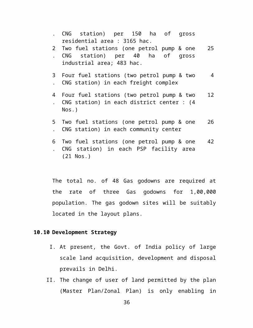
10.9.2 Petrol Pumps/CNG Station & Gas godowns:
As per Master plan-2021 the provision of Petrol Pump / CNG Station
& Gas Godowns are as follows:
1. Two fuel stations (one petrol pump & one CNG station) per 150 ha of gross residential area : 3165 hac.
42
2. Two fuel stations (one petrol pump & one CNG station) per 40 ha of gross industrial area; 483 hac.
25
3. Four fuel stations (two petrol pump & two CNG station) in each freight complex
4
25
4. Four fuel stations (two petrol pump & two CNG station) in each district center : (4 Nos.)
12
5. Two fuel stations (one petrol pump & one CNG station) in each community center
26
6. Two fuel stations (one petrol pump & one CNG station) in each PSP facility area (21 Nos.)
42
The total no. of 48 Gas godowns are required at the rate of three
Gas godowns for 1,00,000 population. The gas godown sites will be
suitably located in the layout plans.
10.10 Development Strategy
I. At present, the Govt. of India policy of large scale land
acquisition, development and disposal prevails in Delhi.
II. The change of user of land permitted by the plan (Master
Plan/Zonal Plan) is only enabling in nature and only lifts a
restriction, which otherwise is to be used as per the use of the
property as per ownership documents.
III. The land has to be used as per the approved layout plan (LOP)
and no change of the use premises can be made contrary to the
land ownership together with land use at premise land even if the
plans (MPD/ZDP) permit suchc user. There is no automatic
conversion of the ‘rural use’ to residential/or any other urban
activity.
IV. After a decision is taken by the Govt. to allow the
betterment/development of private lands, the conversion charges
are to be paid which are leviable on the basis of rates prevalent
on the date of application.
26

V. As per Development Code of MPD-2021, the National Capital
Territory of Delhi is divided into 9 landuse categories and under
Clause 3.0 of MPD-2021 (Page 123) each category is assigned
number of use zones, which shall be further sub-divided into
required number of use premises with or without conditions as
part of the layout plans.
VI. Clause 2(4) of MPD-2021 defines a layout plan indicating
configuration and size of all use premises. As such, without an
approved layout plan, the landuse can not be established for a
premise.
11.0 PROPOSED CHANGE OF LAND USE
The MPD-2021 has been notified by MOUD on 7.2.2007. To
accommodate the policy and modified requirements some
readjustments of landuses has been carried out to optimum
utilization of landuses along the major transport corridors. A care
has been taken not to revise /modify the original land-use
distribution stands approved. The modifications proposed along with
its areas processing under section 11A of DD, Act are placed at
Annexure ‘VI’.
27

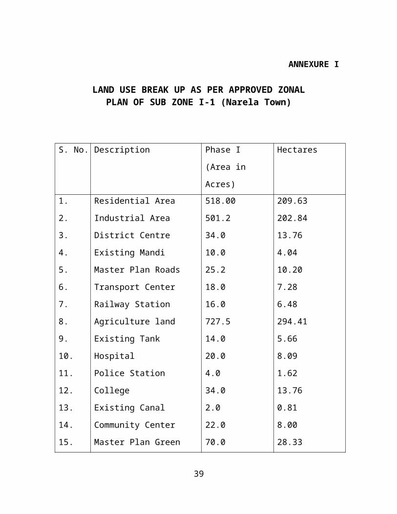
ANNEXURE I
LAND USE BREAK UP AS PER APPROVED ZONALPLAN OF SUB ZONE I-1 (Narela Town)
S. No. Description Phase I (Area in
Acres)
Hectares
1.
2.
3.
4.
5.
6.
7.
8.
9.
10.
11.
12.
13.
14.
15.
Residential Area
Industrial Area
District Centre
Existing Mandi
Master Plan Roads
Transport Center
Railway Station
Agriculture land
Existing Tank
Hospital
Police Station
College
Existing Canal
Community Center
Master Plan Green
518.00
501.2
34.0
10.0
25.2
18.0
16.0
727.5
14.0
20.0
4.0
34.0
2.0
22.0
70.0
209.63
202.84
13.76
4.04
10.20
7.28
6.48
294.41
5.66
8.09
1.62
13.76
0.81
8.00
28.33
Total 2015.00 815.81
28
ANNEXURE - II
VILLAGES/CENSUS TOWNS IN NARELA SUBCITY
S. No.
Name of the Village / Towns Population (2001)
1. Alipur (Cesus Town) 16631
2. Bakaner 21089
3. Bhorgarh 5562
4. Budhpur – Bijapur 1269
5. Holambi Kalan 3876
6. Holambi Khurd 2705
7. Iradat Nagar Alias Naya bans 2509
8. Khera Kalan 4790
9. Khera Khurd 8817
10. Kureni 2586
11. Mamurpur 3465
12. Narela Census Town 38848
13. Sanoth 2909
14. Shahpur Garhi 959
15. Singhola 1878
16. Sirsapur 15043
17. Tikri Khurd 8637
18. Razapur Kalan 0
29
ANNEXURE - III
Tentative list of Unauthorized Colonies falling in Narela Subcity
Sl. No.
Sl. No. as per list
Name of unauthorized colony Sl. no. given by GNCTD
DDA dev. area nos.
M
Zone
N P1 1016 Rajiv Colony Narela Delhi-40. 50 - - - P2 1012 Rajeev Colony Extn. Pio Maniari Road
Narela Delhi-40.256 - - - P
3 1200 Shiv Mandir Colony, Purani Basti, Saziyabad Border, Narela, Delhi-40.
140 - - - P
4 401 Gautam Colony Extn. (Arya Nagar), Safiabad Road, Narela, Delhi-40.
463 - - - P
5 1140 Sanjay Colony, S-235, Safiabad, Road, Narela, Delhi-40.
334 - - - P
6 1139 Sanjay Colony, Near Sabji Mandi, Arya Samaj Road, Narela, Delhi-40.
301 - - - P
7 402 Gautam Vihar Colony, Narela, Delhi-40. 475 - - - P8 125 Bunkner Basti, Near Bliarad Pana, Narela,
Delhi-40382 - - - P
9 129 Basti Bunkner (South) Colony, Lampur Road, Narela, Delhi-40.
230 - - - P
10 60 Ambedkar Colony, Bunkner Extn., Village Bakner, Narela, Delhi-40.
321 - - - P
11 59 Ambedkar Colony Extn., Part-II, Bankner. 736 175 M - -12 890 OM Vihar Colony, Lampur Road, Narela,
Delhi-40.1196 - - - P
13 853 New Basti Lampur, Narela, Delhi-40. 72 - - - P14 1162 Swatentra Nagar Extn., West Gonda
Road, Narela, Delhi-40. 3 - - - P
15 1302 Swatentra Nagar Ph-II (left out portion) Narela.
624 - - - P
16 649 Kureni New Basti, Narela, Delhi-40 285 - - - P17 1247 Shyam Kunj Colony, Tikri Khurd, Delhi-40 160 - - - P18 700 Mahavir Colony, Alipur Road, Bhorgarh,
Narela, Delhi-40.1067 - - - P
19 854 New Colony, Sunnod Ghonga More, Narela Bawana.
1180 - M - -
20 1143 Sannoth Extn. Part-I, II & III, Narela, Delhi-40.
816 Yet to be notified as DAW-175
- - -
21 1214 Shiv Vihar, Holambi Kalan, Delhi-40. 1430 - M - -22 1344 Vashu Vihar Colony, Holambi Kalan. 1211 - M - -23 77 Ankur Vihar Colony, Holambi Kalan. 1212 - M - -24 429 Govind Colony Near Jhangola No-2,
Alipur, Delhi-40.1093 - - - P
25 161 Bhgat Singh Park, Saraspur, Delhi-42. 465 - - - P/C26 141 Bhagat Singh Park Extn., Siraspur Village,
Delhi-42.858 - - - P/C
27 225 Chandan Park, Near Saraspur, Narela, Delhi-42.
431 - - - P/C
28 564 Jeevan Park, Siraspur, Delhi-42. 57 - - - P29 345 Extn. Rana Park Colony, Rana Park,
Siraspur, Delhi-42.127 - - - P
30 1052 Rana Park, Siraspur, Delhi-42. 108 - - - P31 486 Hazari Park, Holambi Kalan, Delhi-82. 73 - - - M
Source :- GNCTD, 2005
30
ANNEXURE – III-A
List of unauthorized regularized colonies (Tentative)
Sl. No.
Name of the colony Municipal Zone Date of approval
1. Swatantra Nagar, Narela Narela 1007/Stg.
Dt. 19.5.81
2. Indra Colony Narela 1007/Stg.
Dt. 19.5.81
3. Narela Mandi Extn. (Part) Narela 1007/Stg.
Dt. 19.5.81
4. Master Colony, Narela Narela 2919/St. Dt. 24.1.1983
5. Shiva Nagar Narela 2919/St. Dt. 24.1.1983
6. Punjabi Bagh Colony
‘G’ Block
Narela 2919/St. Dt. 24.1.1983
7. Vijay Nagar Narela 2919/St. Dt. 24.1.1983
Source :- M.C.D., 2006
31
ANNEXURE IV
DETAILS OF FACILITY AREAS
S. No. Name of Facility Areas Area (In Ha) Facility Proposed
1. FA-1 10.0 2 Proposed College, Hospital, Medical College
2. FA-2 49.0 Hospital ‘A’, Police Station, Working Women Hostel
3. FA-3 9.0 Hospital ‘C’, Hospital ‘D’, 2 (Maternity Hospital, Nursing Home), 1 Community Hall, 1 ESS 66 KV, Hospital. ‘A’, Fire Station
4. FA-4 4.0
5. FA-5 40.0 Hospital ‘C’, Hospital ‘D’, 2 (Maternity Hospital, Nursing Home), 1 Community Hall, 1 ESS 66 KV, Vet (h), Vocational Traning, Police Station, Veterinary Institute
6. FA-6 32.0 Hospital ‘C’, Hospital ‘D’, 2 (Maternity Hospital, Nursing Home), 1 Community Hall, 1 ESS 66 KV, Hos. ‘B’, Vocational Traning, Fire Station, Care Centre for physically challenged orphanage, Children Centre, Old Age Home, Religious Centre
7. FA-7 21.0 Hospital ‘C’, Hospital ‘D’, 2 (Maternity Hospital, Nursing Home), 1 Community Hall, 1 ESS 66 KV
8. FA-8 51.0 All India Radio
9. FA-9 54.0 Hospital ‘C’, Hospital ‘D’, 2 (Maternity Hospital, Nursing Home), 1 Community Hall, 1 ESS 66 KV, Hospital ‘A’, Vocational Traning, Fire Station, Care Centre for physically challenged, Working Women Hostel, Head Post Office, Telephone Exchange, Old Age Home
32
10. FA-10 56.0 Hospital ‘C’, Hospital ‘D’, 2 (Maternity Hospital, Nursing Home), 1 Community Hall, 1 ESS 66 KV, Religious Centre, Science Centre
11 FA-11 26.0 Hospital ‘C’, Hospital ‘D’, 2 (Maternity Hospital, Nursing Home), 1 Community Hall, 1 ESS 66 KV, Hospital ‘B’, Police Station, Fire Station
12 FA-12 9.7 All India Radio
13 FA-13 18.0 Hospital ‘C’, Hospital ‘D’, 2 (Maternity Hospital, Nursing Home), 1 Community Hall, 1 ESS 66 KV, Fire Station
14 FA-14 50.0 Hospital ‘C’, Hospital ‘D’, 2 (Maternity Hospital, Nursing Home), 1 Community Hall, 1 ESS 66 KV, Hospital ‘B’, Professional Collages, Police Station
15 FA-15 37.0 Hospital ‘C’, Hospital ‘D’, 2 (Maternity Hospital, Nursing Home), 1 Community Hall, 1 ESS 66 KV, Vet (h), Fire Station
16 FA-16 42.3 Hospital ‘C’, Hospital ‘D’, 2 (Maternity Hospital, Nursing Home), 1 Community Hall, 1 ESS 66 KV, Police Station
17. FA-17 60.0 Hospital ‘C’, Hospital ‘D’, 2 (Maternity Hospital, Nursing Home), 1 Community Hall, 1 ESS 66 KV, Hospital ‘A’, Fire Station, Care Centre for physically challenged, International Convention Centre, Exhibition Cum Fair Ground
18. FA-18 20.0
19. FA-19 20.0 Hospital ‘C’, Hospital ‘D’, 2 (Maternity Hospital, Nursing Home), 1 Community Hall, 1 ESS 66 KV
20. FA-20 39.0 Hospital ‘C’, Hospital ‘D’, 2 (Maternity Hospital, Nursing Home), 1 Community Hall, 1 ESS 66 KV,
33
Hospital ‘B’, Fire Station, Working Women Hostel Orphanage, Children Centre, telephone Exchange, Old Age Home
21. FA-21 29.0
22. FA-22 115.0 Hospital ‘C’, Hospital ‘D’, 2 (Maternity Hospital, Nursing Home), 1 Community Hall, 1 ESS 66 KV, Fire Station, University Campus, Medical College, Distt. Office & Battalion, Police Lines
23. FA-23 16.0 JAIL
24. FA-24 29.0 Hospital ‘C’, Hospital ‘D’, 2 (Maternity Hospital, Nursing Home), 1 Community Hall, 1 ESS 66 KV, Hospital ‘B’, Vet (h), Police Station, Fire Station, Orphanage, Children Centre, Fire Training Institute, Disaster Management
25 FA-25 23.0 Divisional Sports Complex
34
ANNEXURE – V
LIST OF VILLAGE PONDS – ALIPUR BLOCK
Sl. No. Name of the village / Census town (CT)
No. of Ponds Land Ownership
Surface Area (Sq.Mt.)
1 Bankner A BDO 9,000
B BDO 7,000
2 Lampur A BDO 3,500
3 Sanoth A BDO 25,000
B BDO 25,000
C BDO 2,500
4 Holambi Khurd A BDO 2,500
B BDO 4,500
5 Naya Bans A BDO 1,800
B BDO 2,500
6 Narela A BDO 2,500
B BDO 3,000
Mughal Tank C BDO 4,000
Source :- MCD
35
ANNEXURE – VI
Modification / changes in approved Zonal Plan
CATEGORY I- Already notified through MPD-2021 dated. 7.02.2007
Sl. No.
Pocket No.
Land-Use Area in hact.
Remarks
As per approved zonal development plan of Narela
Proposed modified landuse
1. 3 A. B. C. D. E. F.
ResidentialGovt. officeGovt. officePSP facilities IndustrialResidential
RecreationalRecreationalResidentialResidentialPSP facilitiesPSP facilities
42.004.0012.0040.006.004.00
All these changes have been made in sector A1-A4 due to shifting of Jail site and utilization of land under high tension line as “green” (recreational).
2. 4 Residential PSP facilities 1.00 As per the request received from local residents for cremation ground and graveyard.
3. 5 PSP facilities Govt. Office 16.00 This change is due to shifting of govt. Offices from sector A1-A4 (details given against pkt. 3/b and 3/c) as explained in Pkt.3.
4. 6 Recreational PSP facilities 16.00 This change is due to shifting of jail from sector A1-A4 (details given against pkt.3/A).
5. 7 Recreational Utility 10.50 This site was already under the Jal Board. Land has been shown as “utility”.
6. 23 PSP facilities Recreational 204 These two pockets have huge open space area with transmission tower. Keeping part of the land for “PSP” facility, rest of the open area is proposed for “recreational”.
7. 24 PSP facilities Recreational 38.40
8. 25 Circulation Residential 6.0 60M R/W reduced to 30m R/W, considering the overall road network plan of Narela Subcity.
36
CATEGORY-II- Being notified under section 11-A of DD, Act under the modified zonal Plan (P-1).
Sl. No.
Pocket No.
Land-Use Remarks
As per approved zonal development plan of Narela
Proposed modified landuse
Area in hact.
1 1 Recreational Residential 27.00 This modification was approved by the TC on 16.11.05.
2 2 Recreational PSP facilities 115.00 This modification was approved by the TC on 16.11.05.
3 8 Recreational PSP facilities 21.00 All these modification / Adjustments were approved by the TC on 16.11.05.
4 9 Residential PSP facilities 13.805 10 Residential Industrial 6.006 11 Residential PSP facilities 25.027 12 Utility (water
treatment plant)Recreational 10.50 This is in view of pocket-7.
This modification was approved by the TC on 16.11.05.
8 13 Recreational Residential 26.00 All these modification / Adjustments were approved by the TC on 16.11.05.
9 14 PSP facilities Residential 17.56 All these modification / Adjustments were approved by the TC on 16.11.05.
10 16 Residential PSP facilities 19.60
11 17 Residential Recreational 27.00All these modification / Adjustments were approved by the TC on 16.11.05.
12 18 Residential PSP facilities 32.00
13 19 Residential PSP facilities 17.4814 22 PSP facilities Residential 25.40
Note : All these changes in fourteen pockets are proposed to :1. Adjust the above (Category-I) 8 changes incorporated in MPD-2021.2. Intensity the urban extn. Corridors (including proposed metro corridors
UER- II) with non-residential land use. 3. Pocket No. 15, 20 & 21 were earlier considered for T.C. but due to
realignment of UER-III the change is not required.
37
CATEGORY-III- Being notified under section 11-A of DD, Act under the modified zonal Plan (P-1) due to realignment of UER-III for approval of T.C.
Sl. No.
Pocket No.
Land-UseRemarksAs per approved
zonal development plan of Narela
Proposed modified landuse
Area in hact.
1 26 Circulation A. ResidentialB. PSP FacilityC. CommercialD. ResidentialE. Residential
7.45.43.78.0
11.8
Shifting the alignment of UER-III.
2 27 Recreational (Green along UER-III)
a. Resedentialb. PSP Facilityc. Commerciald. Residential e. Residential
7.45.43.78.0
11.8
Shifting of the Green along UER-III.
3 28 A1. PSP FacilityB1. ResidentialC1. CommercialD1. ResidentialE1. Residential
Circulation Proposed (UER-III)
6.83.02.07.5
11.0
New alignment of UER-III.
4 29 a1. PSP Facilityb1. Residentialc1. Commerciald1. Residentiale1. Residential
RecreationalRecreationalRecreationalRecreationalRecreational
6.83.02.07.5
11.0
New alignment of UER-III.
5 30 PSP Facility Residential 23.5 Shifting of landuse along UER-III.
6 31 Commercial Residential 5.6 Shifting of landuse along UER-III.
7 32 PSP Facility Residential 25.2 Shifting of landuse along UER-III.
8 33 Residential Transportation 6.0 Adjustment of area plan UER-III.
9 34 Residential PSP Facility 23.5 Shifting of landuse along UER-III.
10 35 Residential Commercial 5.6 Shifting of landuse along UER-III.
11 36 Residential PSP Facility 25.2 Shifting of landuse along UER-III.
12 37 Residential PSP Facility 15.0 Shifting of landuse along UER-III.
13 38 Residential Commercial 6.3 Shifting of landuse along UER-III.
14 39 Residential PSP Facility 12.5 Shifting of landuse along UER-III.
15 40 Recreational PSP Facility 23.0 Change proposed in MPD-2021 (Divisional Sports Complex).
16 41 Residential Circulation 18.0 Proposal of 60m R/W road in south of UER-III near Siras Pur & shifting or road along Rly. Line.
38
ANNEXURE – VII
IDENTIFICATION OF STREETS FOR COMMERCIAL USE IN NARELA ZONE (as per notification dt. 15.9.2006)
Sl. No.
Name of the Road/Street Stretch of Road From – To ROW (Mtrs)
1. Arya Samaj Road Ram Dev Chowk to Y Turn 182. Narela – Lampur Road t. Point to Railway X-ing 24
IDENTIFICATION OF COMMERCIAL STREETS IN NARELA ZONE (as per notification of GNCTD dt. 12.4.2007)
Sl. No.
Name of the Road/StreetStretch
R.O.W (In Mtrs)
From To1. Main Swatantar Nagar
RoadBawana
Narela RoadNarela Lampur
Road9.00
2. Narela Bawana Road
Plot No.68 Plot No. 2152 only northern side
30.00
H. No. 2142 Railway Boundary 30.00Ram Dev Chowk
Railway crossing Bawana Road
30.00
Swami Swaroopanan
Railway crossing 30.00
Chaudhary Meer Sing Marg Narela Bawana
Road
Bankner Railway crossing
13.00
3. Punjabi Colony Road Physical Centre
Govt. Girls Sr. Sec. School
7.00
39
ANNEXURE – VIII
IDENTIFICATION OF MIXED LANDUSE STREETS IN NARELA ZONE (as per notification of GNCTD dt. 12.4.2007)
Sl. No.
Name of the Road/StreetStretch
R.O.W (In Mtrs)
From To1. Hawaldar Mukhtyar Singh End of Park Main Auchandi
Road Bawana6.00
2. Shivaji Nagar Road MCD Park L Point of Plot No. 73 only eastern
side
6.00
40
41
42