Embed Size (px)
Citation preview

SANITARY AND ZONING ORDINANCES ADOPTED
In a series of actions significant to regional land use plan implementation, several county and local units of government within the Region have, in recent months, completed and adopted revised zoning ordinances and new sanitary codes. The substantive content of these ordinances demonstrates that local governments within the Region are becoming increasingly aware of the pressing need to deal more forcefully with the serious environmental and developmental problems at hand. These recent ordinance or code adoptions include the following: Waukesha County Community Health (Sanitary) Code, Racine County Zoning Ordinance, Kenosha County Floodland and Shore land Sanitary Ordinance, and City of Racine Floodland Zoning Ordinance.
Waukesha County Community Health Code Mter over five years of study, public hearings, and deliberation, the Waukesha County Board of Health, on May 1, 1970, adopted Chapters 1 and 2 of the Waukesha County Community Health Code to regulate the location, construction, installation, alteration, design, and use of private sewage disposal systems and sites, including septic tanks, seepage pits, disposal fields, and holding tanks. Waukesha County thus becomes the third county within the seven-county Southeastern Wisconsin Region to adopt a county-wide sanitary code based in large part upon the detailed soil survey and interpretive analyses prepared for the Region by the U. S. Soil Conservation Service. Walworth County adopted a county-wide sanitary code in August 1966, and Washington County adopted such
n 0 ~ ~
~CII _0 CIte
-t I m ) CIt -I m
~ -~
-

SANIT ARY AND ZONING ORDINANCES-Continued
a code in April 1969. The adoption of such sanitary codes was recommended by the Commission for all counties in the Region, except Milwaukee County, as an important regional land use plan implementation action. Milwaukee County was excepted from this recommended plan implementation action because the entire County is scheduled to be provided with public sanitary sewerage service by the Metropolitan Sewerage Commission of the County of Milwaukee.
It is important to note that the Waukesha County Community Health Code was enacted under Section 140.09 of the Wisconsin Statutes, which Section contains a general grant of power to County Boards of Health to adopt and enforce rules and regulations deemed necessary to protect and preserve public health and, as such, makes the sanitary code applicable to all incorporated, as well as all unincorporated, areas of the County. The Walworth and Washington County Sanitary Codes were enacted under Section 59.07(51) of the Wisconsin Statutes which, while authorizing county boards to adopt and enforce sanitary codes, limits the application of the codes only to such cities, villages, and towns which do not have ordinances in effect concerning the same subject matter.
The Waukesha County Community Health Code provides an option whereby cities, villages, and towns within the County can assume the responsibility for administration of the regulations. At the request of the local governmental unit, the County Health Officer will appoint a local authorized agent to administer the Code provisions under the general supervision of the Health Department. The local option also provides for the retention of permit fees at the local level if the local unit of government elects to administer the Code.
The significance of the sanitary codes to regional land use plan implementation is related to the detailed soil survey data incorporated into the codes. In the Waukesha County Code, for example, all those soil types within the County that have been rated as having "very severe" limitations for the operation of soil absorption sewage disposal systems 2

SANITARY AND ZONING ORDINANCES-Continued
are declared unusable for such systems; and permits may not be issued for proposed installations on those soils. On those soils rated as having "severe" limitations for the proper absorption of septic tank effluent, the Code requires that measures be taken to ensure proper operation before the system can be installed. Provisions are made in the Code for contesting the soil classification and mapping by appeal to the Waukesha County Board of Health. The enactment of this Code by the Board is of great importance to the sound future development of Waukesha County-a County that is now experiencing significant public health and sanitation problems caused by failures of septic tank systems installed in large numbers on poorly suited soils during periods of rapid urban growth in the 1950's and 1960's.
Racine County Zoning Ordinance On December 10, 1969, the Racine County Board of Supervisors adopted the regulatory text of a new County Zoning Ordinance containing, in addition to the traditional zoning districts and regulations, floodland and shore land regulations designed to implement the adopted Root River watershed plan and the recently completed Fox River watershed plan, as well as to meet the requirements for effective county floodplain and shore land zoning contained in the State Water Resources Act of 1965. The Ordinance was adopted after over two years of intensive work by the Racine County Planning Committee, representatives of all nine Racine County towns, and a Citizens Advisory Committee.
Adoption of the Ordinance by the County Board is only the initial step in what is expected to be a year-long effort to complete the comprehensive rezoning process through the preparation of town zoning maps, the adoption of the Ordinance by each of the town boards, and the adoption of the maps by both the individual town boards and the County Board. This comprehensive rezoning procedure is being carried out pursuant to Section 59. 97 of the Wisconsin Statutes. The old Racine County Zoning Ordinance remains in effect during the one-year period. It has super-
3

SANITARY AND ZONING ORDINANCES-Continued
imposed upon it, however, the floodland and shore land regulations of the new ordinance, which became effective immediately upon adoption by the County Board. The more immediate action on the flood land and shoreland regulations was taken not only because the state-enabling legislation does not require town board ratification of floodland and shoreland regulations, as is required for all other comprehensive zoning regulations, but also because failure of the County to act might precipitate state action under the Water Resources Act.
As noted, each of the nine Racine County towns has until nearly the end of this year to adopt the new ordinance and a zoning map. In the alternative, a town may elect to adopt a zoning ordinance and map independent of the County ordinance, with such ordinance and map and any subsequent amendments thereto being subject to County Board approval. If a town elects to do nothing, the old zoning simply expires at the end of the one-year period; and the town would be unzoned. It is important to note, however, that, whatever the individual towns may elect to do, the County flood land and shore land regulations will remain intact.
The new Racine County floodland and shore land regulations follow closely the Commission's recommendations set forth in the amendments to the Commission Model Zoning Ordinance contained in SEWRPC Planning Guide No.5, Floodland and Shore land Development Guide. Of particular significance are the provisions in the new ordinance prohibiting dumping, filling, septic tank sewage disposal facilities, residential structures, and basements in all floodways and floodplains. The enactment of this provision represents a substantial plan implementation step with respect to the Root River and Fox River watershed plans as they affect Racine County. The floodways and floodplains that were determined through engineering studies in the two comprehehsive watershed planning programs are being utilized as a basis for the delineation of the floodland and shore land districts and, thereby, the administration of the new Racine County Ordinance. Some of the Significant shoreland regulations include special review and approval provisions for site develop-4

SANITARY AND ZONING ORDINANCES-Continued
ment in the shoreland areas, including tree-cutting, shrubbery-clearing, and earth-moving activities. The Ordinance also prohibits agricultural activities in shoreland areas, unless such activities are conducted in accordance with good soil conservation practices, to be formulated and adopted by the Racine County Soil and Water Conservation District supervisors.
Kenosha County Floodland and Shore land Sanitary Ordinance The Kenosha County Board of Supervisors, on February 17, 1970, upon recommendation of the Kenosha County Zoning Committee, adopted a Floodland and Shore land Sanitary Ordinance for the County. The Ordinance contains regulations concerning the location, construction, installation, alteration, design, and use of all private water supply, sewage disposal, and other waste disposal systems and sites proposed to be located within the floodland and shore land areas of Kenosha County. The Ordinance, adopted pursuant to Sections 59.07(51) and 144.26 of the Wisconsin Statutes, is effective in the floodland and shore land areas of the unincorporated portions of Kenosha County. The floodlands are to be delineated on the basis of the flood profiles and flood hazard maps prepared under the Commission's Fox River watershed study, under the U. S. Army Corps of Engineers Des Plaines River floodplain information study, and under similar subsequent studies as these studies are completed for other watersheds in the County. Like the Waukesha County Community Health Code, the Kenosha County Floodland and Shore land Sanitary Ordinance utilizes the detailed soil survey and interpretive analyses as a basis for the regulation of the installation of private sewage disposal fields. Such disposal fields cannot be installed on those soils rated as having "very severe" limitations for the absorption of sewage effluent. Disposal fields are also prohibited from being located on floodlands. The Ordinance is proposed to be administered through the existing Kenosha County Zoning Department. Deputy sanitary inspectors are to be appointed for each of the eight Kenosha County towns.
5

SANITARY AND ZONING ORDINANCES-Continued
City of Racine Floodland Zoning Ordinance Amendments In another significant plan implementation action, the Common Council of the City of Racine, on March 17, 1970, adopted amendments to the City of Racine Zoning Ordinance relating to flood land regulations. The adoption of such regulations was recommended by the Commission in the Root River watershed plan, which plan determined the limits of the floodway and floodplain to be used in the administration of the amended ordinance. In terms of substance, the flood land regulations contained in the amended City of Racine Zoning Ordinance are nearly identical to the regulations contained in the aforementioned Racine County Zoning Ordinance, thus providing for continuity of enforcement along the entire length of the Root River and its tributaries within Racine County. By adopting the new floodland amendments to the existing Ordinance, the City of Racine, in addition to taking an important watershed plan implementation action, has complied with the State Water Resources Act of 1965. The Commission is currently working with the Cities of Burlington and West Bend in efforts to create and enact similar floodplain regulations along the Fox and Milwaukee Rivers, respectively.
SEWRPC NOTES
Pursuant to Commission Bylaws, the annual election of Commission officers was held at the Commission quarterly meeting held on December 4,1969, in the Milwaukee County Courthouse. The Commission unanimously approved the Nominating Committee report that the 1969 officers of the Commission be elected to suceed themselves for calendar year 1970. The reelected officers are: George C. Berteau, Kenosha County, who was reelected to his ninth term as Chairman; Ray F. Blank, Ozaukee County, who was reelected to his second term as Vice-Chairman; Richard W. Cutler, Milwaukee County, who was reelected to his sixth term as Secretary; and Joseph A. Schmitz, Washington County, who was reelected to his second term as Treasurer
6

SEWRPC NOTES-Continued
1970 Commission Officers
George C. Berteau, Chairman Ray F. Blank, Vice-Chairman
Richard W. Cutler, Secretary Joseph A. Schmitz, Treasurer
7

SEWRPC NOTES-Continued
Commission Bylaws provide that the Executive Committee be composed of the four officers of the Commission and such additional members as to ensure that each of the seven constituent counties is represented on the Executive Committee. The Executive Committee meets monthly and is empowered to act for the full Commission on all matters except the adoption of an annual budget and the adoption of regional plan elements. The Executive Committee for 1970, elected at the December quarterly meeting, consists of the four above named Commission officers and the following Commissioners: James F. Egan, Ozaukee County; Eugene Hollister, Walworth County; Milton F. LaPour, Racine County; and Lyle L. Link, Waukesha County.
Subsequent to the December quarterly meeting, Chairman Berteau announced appointments to the three standing committees of the Commission for 1970. These appointments are as follows:
8
ADMINISTRATIVE COMMITTEE
Milton F. LaPour, Chairman Lyle L. Link, Vice-Chairman Leonard C. Rauen
Joseph A. Schmitz John D. Voss
PLANNING AND RESEARCH COMMITTEE
James F. Egan, Chairman Ray Schmidt, Vice -Chairman Albian O. 'Behrens George C. Berteau Richard W. Cutler
Charles J. Davis Lyle L. Link Richard C. Nowakowski Leonard C. Rauen Norman C. Storck
INTERGOVERNMENTAL AND PUBUC RELATIONS COMMITTEE
Eugene Hollister, Chairman Ray F. Blank, Vice-Chairman George C. Berteau Jacob Kammerzelt
Theodore F. Matt Richard C. Nowakowski Joseph A. Schmitz Garth R. Seehawer

SEWRPC NOTES-Continued
NEW COMMISSIONER APPOINTED
Mr. Paul F. Quick, Hartford businessman, has been appointed to the Regional Planning Commission by Governor Warren P. Knowles from a Washington County Board-approved list of candidates . Mr. Quick replaces Mr. Arnold R. Finch, who recently resigned from the Commission because relatively long periods of time spent out of state each year prevented his full participation in the work of the Commission. Mr. Quick will serve an unexpired term on the Commission ending September 15, 1974. Mr. Quick's activities in public affairs have included the following: Former to'lember and Chairman, City of Hartford Plan Commission; Member, SEWRPC Intergovernmental Coordinating Committee on Regional Land Usc-TransJX)rtalion Planning; Former PreSident, Hospital Advisory Board, City of Hartford; Former Member, Hartford Pub lie Affairs Committee; and Former Member, Hartford Industrial Development Committee. He is a mechanical engineering graduate of Mnrquette University and presently serves as Manager of Engineering for the Chrysler Outboard Corporation, Hartford, Wisconsin.
REGIONAL HOUSING STUDY PROSPECTUS PUBLISHED
Acting upon a request from the Mayor of the City of Milwaukee, the Commission has recently completed and published a Regional Housing Study Prospectus, which explores the need for, and feasibility of, and which sets forth the major work elements of, a regional housing study for the Southeastern Wisconsin Region. The Prospectus was prepared by the Commission staff, with the advice of a 20-member Technical Advisory Committee on Regional Housing Studies. This Committee, which brought a broad range of expertise in the housing field to the Commission effort, includes representatives from: the mortgage banking community; private land development firms; the home building industry; real estate appraisers; local citizen groups; church groups; federal, state, and local housing agencies; the university community; and other segments of the private sector of the economy.
9

REGIONAL HOUSING PROSPECTUS-Continued
This Prospectus was also intended to serve as a first step in the preparation of a "housing element" in the evolving comprehensive plan for the Region, as required by the U. S. Congress in the Federal Housing and Urban Development Act of 1968. Under this Act planning agencies receiving federal planning grants must include a housing element in their planning program. The Commission submitted the Housing Prospectus in fulfillment of the requirement for the completion of an initial housing element by September 30, 1969. This initial housing element was approved by the U. S. Department of Housing and Urban Development on January 16, 1970.
In preparing the Regional Housing Study Prospectus, investigations by the Technical Advisory Committee and the Commission staff revealed that at least 13 individual factors contribute to the need for a regional housing study and that these factors can be grouped under three major considerations. The three considerations and the contributing factors identified are:
10
1. The lack of timely, uniform, areawide information on the supply of, and demand for, housing within the Region, particularly in terms of:
a. The quantity and quality of the existing supply of housing.
b. The characteristics of housing demand.
c. The identification of the regional housing market(s).
d. The present public land use control policies and practices.
e. The shortage of certain types of housing units.
f. The lack of environmental considerations in re sidential developments.

REGIONAL HOUSING PROSPE CTUS-Continued
g. The practice of discrimination as it affects the free choice of housing.
h. The filtration of housing.
i. The resistance to new technology in the housing industry.
2. The increased role of government in the housing field, as indicated by its involvement in:
j. Housing loan, grant, and insurance programs.
k. Relocation housing programs.
1. Public housing programs.
m. Housing-related programs.
3. The determination of true housing needs as distinguished from effective housing demand.
The lack of uniform, areawide data on the supply of, and demand for, housing; the complex interrelationships between housing supply and demand factors; governmental constraints and program incentives; and the pressing need to provide all families and individuals with at least a minimum level of decent, safe, and sanitary housing have collectively precipitated a need for a regional housing study.
In addition to fulfilling the housing element requirement of the Housing and Urban Development Act of 1968, the proposed regional housing study would address itself to specific housing and housing-related problems that will include but not be limited to: a determination of existing and potential housing surplus or deficit for various income levels; a consid-
11

REGIONAL HOUSING PROSPECTUS-Continued
eration of the amount, location, and cost of developable land for housing in the Region related to existing institutional constraints, such as zoning ordinances, subdivision regulations, and other land use controls; and a detailed examination of all housing programs at the local, state, and national level to be coupled with recommendations as to the role that the various levels and agencies of government can assume now and in the future in providing decent, safe, and sanitary housing for all residents of the Region but paying particular attention to those families and individuals who need housing but cannot afford it.
The regional housing study will also contribute substantially to the resolution of housing relocation problems caused by construction activities connected with necessary public works programs, such as public buildings (schools, neighborhood centers, etc.), parks, urban renewal, and streets and highways, through a long-range analysis of the impact of proposed public works and improvement programs on relocation efforts. The housing study will identify the applicable areas for relocation housing; quantify the magnitude of relocation assistance needed; provide information about alternative solutions to relocation problems; and alert local officials to potential problem areas concerning nonscheduled but logical future public works improvement. In this respect the regional housing study will greatly assist in implementing the new uniform relocation assistance act enacted by the Wisconsin Legislature as Chapter 409 of the Laws of Wisconsin 1969. This act requires public agencies vested with the power of eminent domain under Chapter 32 of the Wisconsin Statutes to provide relocation services and assistance to persons, businesses, and farm operations displaced by public works projects.
The proposed housing study would also constitute a major contribution to one of the Commission's three principal functions; namely, areawide research. A housing study would facilitate the collection and analYSis of basic planning data not presently available for the Region as
12

REGIONAL HOUSING PROSPECTUS-Continued
a whole or for specific subareas of the Region and would assist private, as well as local, state, and federal, government agencies in finding sound solutions to housing and housing-related problems within the rapidly urbanizing Region.
The total net project cost of the recommended three-year regional housing study is estimated at $531,000. The Prospectus recommended that two-thirds of the funding be provided by the U. S. Department of Housing and Urban Development and that one-third be provided by the seven constituent counties of the Region. The Prospectus further recommended that the regional housing study begin in July 1970 with the preparation of detailed study design memoranda. It is anticipated that the majority of the basic inventories will be completed in 1971; analyses and forecasts, in 1972; and the preparation of final housing recommendations, by June 1973. Copies of the Prospectus are available from the Commission offices at a price of $1.50 within the Region and $3.00 outside the Region.
I
MENOMONEE RIVER WATERSHED PLA~NING PROGRAM PROSPECTUS PUBUSHED .
The Commission has completed and published a Menomonee River Watershed Planning Program Prospectus. As noted in an earlier issue of this Newsletter, the Commission has received requests from the Common Council of the Cities of Brookfield and Wauwatosa and from the Milwaukee County Board of Supervisors to undertake a comprehensive planning study of the Menomonee River watershed, looking to the ultimate resolution of the serious and costly flooding, water pollution, and related problems existing within that watershed and affecting the property and general welfare of its citizens. Acting on these requests, a 15-member Menomonee River Watershed Committee was established and given the charge of preparing a Prospectus intended to document the need for, and outline the scope, content, organization, timing, and budget of, a comprehensive planning program for the Menomonee River watershed. This
13

MENOMONEE RIVER WATERSHED PROSPECTUS-Continued
program would be the fourth comprehensive watershed planning program undertaken by the Commission, the first three being for the Root, Fox, and Milwaukee Rivers (see Map 1).
The Committee found that five major water and water-related resource problems existing in the watershed dictate the need for undertaking a study of the Menomonee River watershed at this time. These factors are:
• Flooding and flood damages.
• Water pollution.
• Park and open-space needs.
• Industrial water use and supply.
• Changing land use.
The Prospectus notes that solutions to the foregoing problems identified in the Menomonee River watershed can be effectively accomplished only within the framework of a comprehensive planning program which recognizes the watershed as an integrated land-water resource unit having a complex community of interest among its residents.
As in the past Commission watershed planning programs, the Menomonee River Watershed Planning Program Prospectus proposes extensive inventories relative to surface water data, ground water data, water quality conditions, water use, land use, and public utility facilities. These basic inventories would provide the data needed to analyze effectively the land and water resource problems, characteristics, and capabilities of the· entire watershed. The Prospectus further recommends that alternative watershed plans be prepared for public evaluation and selection, including proposals for erosion and {)edimentation control,
14

Mop r
MENOMONEE RIVER WATERSHED
'" • I ,£ "
LI A,' I ,;
II ICllfl. ,\,
1 t :
hn:'" 00: ::.:pr-_ _ !'1"" .. ...
15

MENOMONEE RIVER WATERSHED PROSPECTUS-Continued
flood damage abatement and flood protection, urban and rural drainage improvement, streamflow augmentation, water quality protection and pollution abatement, resource conservation and recreation facilities, stream channel stabilization and beautification, and land use development, not only in the riverine areas of the watershed but over the entire watershed. From these foregoing alternative proposals, a comprehensive watershed plan would be synthesized and recommended for adoption after public hearings.
The total cost of the program is estimated at $232,900. The Prospectus recommends that this cost be shared on the following basis: U. S. Department of Housing and Urban Development, 20 percent; U. S. Department of the Interior, Federal Water Pollution Control Administration, and the Wisconsin Department of Natural Resources, 68 percent; and the four counties within the watershed-Milwaukee, Ozaukee, Washington, and Waukesha-the remaining 12 percent. Funding arrangements are incomplete at this time, with funding being sought on the basis recommended in the Prospectus.
The program calls for study organization and initial inventory operations to be completed during 1971, with the remaining inventory operations and analyses and forecasts to be completed in 1972 and with alternative plan preparation and final plan selection scheduled for 1973. Copies of the Prospectus are available from the Commission offices at a price of $1.50 within the Region and $3.00 outside the Region.
ORAP LOCAL PARK AID GUIDELINES ANNOUNCED
Guidelines have recently been announced relating to the distribution and eligibility requirements for the state financial aids made available under the recently enacted Outdoor Recreation Act Program (ORAP) 200 Legislation for local park acquisition and development. The ORAP law was enacted by the Wisconsin Legislature on January 17, 1970, as Chapter 353 of the Wisconsin Laws of 1969. The ORAP law provides for twin
16

ORAP LOCAL PARK AND GUIDEUNES-Continued
state bonding programs to deal with the pressing need to provide water pollution abatement and park facilities. If fully carried out over a contemplated 10-year period, a total of about $144 million would be made available to local units of government within the state for pollution abatement purposes and about $56 million for park and outdoor recreation purposes.
Of particular importance to local communities in the Region at this time are the guidelines recently approved to make available $2 million during the current biennium through the Wisconsin Department of Natural Resources as state grants-in-aid for local park acquisition and development projects: $1 million during fiscal year 1970 and an additional $1 million during fiscal year 1971. This total allocation for local park aids will be divided among the 72 Wisconsin counties on a formula which distributes 70 percent of the total funds on the basis of county population and 30 percent of the total funds on an equal basis among the 72 counties. This will result for the current biennium, ending on June 30, 1971, the following amounts being made available to the seven southeastern Wisconsin counties and to the cities, villages, and towns within these counties: Kenosha County, $44,020; Milwaukee County, $363,354; Ozaukee County, $22,246; Racine County, $57,862; Walworth County, $26,278; Washington County, $24,532; and Waukesha County, $70,496.
The Department of Natural Resources has determined, in published preliminary guidelines, that the types of eligible projects, project priority, and project transmittal procedures and application forms for ORAP local park funding will be the same as for the established land and water conservation fund (LAWCON) program. All aided projects must be in accordance with the published State Outdoor Recreation Plan. On January 1, 1971, unused county allocations will be automatically transferred to a planning area (regional) fund and thus be made available for adjacent counties to use. On April 1, 1971, any unused planning area funds will be transferred to a statewide fund. The state ORAP local park assistance grants must be matched by local contributions. The
17

ORAP LOCAL PARK AND GUIDEIlNES-Continued
state ORAP funds may be used, however, as matching funds for federal park and open-space acquisition and development grants. The combination of federal and state aids may not exceed 75 percent of the total project costs. In addition, with respect to development projects, the combination of federal and state aids may not exceed 50 percent of the total project cost. Further information on the ORAP local parks aids program may be obtained by contacting the Wisconsin Department of Natural Resources, Bureau of Aid Programs, Box 450, Madison, Wisconsin 53701.
CENTENNIAL ANNIVERSARY OF WISCONSIN ACADEMY OF SCIENCES, ARTS AND LETTERS
The 100-year anniversary of the Wisconsin Academy of Sciences, Arts and Letters is being celebrated during 1970 in meetings held in Madison during May and scheduled to be held in Milwaukee during October. The Academy was incorporated by charter by the Wisconsin Legislature on March 18, 1870, and has served the people of the State of Wisconsin for 100 years in many ways, with its general purpose being to encourage investigation and dissemination of correct views in the various departments of science, literature, and the arts. The Academy has published over the years about 60 volumes of original science research papers on the people of Wisconsin and its natural resources. The Academy also sponsored the original geological and natural history survey some 70 years ago. The theme of the centennial meeting deals with environmental protection, a subject of interest and concern among Academy members throughout its long and distinguished history.
ST ANDARD SEWER AND WATER INSTALLATION SPECIFICATIONS PROPOSED
In an important attempt to promote the use of uniform specifications for sanitary and storm sewer and water supply facility construction throughout the Milwaukee metropolitan area, the Public Works Improvement
18

STANDARD SEWER AND WATER INSTALLATION-Continued
Program, Inc., an organization of Milwaukee area sewer and water contractors, has, with the assistance of an advisory committee of local public works officials, prepared and published a recommended set of standard specifications. The principal objective of this effort is to encourage the use of standard specifications with respect to construction practices and the design of inlets and such basic items as manholes, catch basins, and valve boxes so that greater efficiency and economy in public works installations can be achieved. The existing and highly varying requirements for sewer and water facilities in the many communities in the area unnecessarily add to the cost of the great amount of work being done. The standard specifications, which took about three years to prepare, are set forth in a 130-page draft now being circulated for review. Copies of the draft may be obtained at a cost of $5.00 each from the Public Works Improvement Program, Inc., 2835 N. Mayfair Road, Milwaukee, Wisconsin 53222.
SURVEY CORNER PERPETUATION LAW ENACTED
Chapter 499 of the Laws of Wisconsin 1969 provides that, beginning in 1970, each county shall annually inspect, reestablish, monument or remonument, and reference at least 5 percent of all the U. S. Public Land Survey section and quarter-section corners within its boundaries. Within a 20-year period, therefore, all of the original U. S. Public Land Survey monuments will be established or reestablished and thereafter perpetuated. The county surveyor is given the responsibility for performing the required survey work with the cost of perpetuating the corners to be paid out of the county road and bridge fund or other county fund, as may be determined by the County Board of Supervisors.
The basic principles of real property law in Wisconsin had their orIgIns in England, where the problem of locating real property boundaries was based upon the use of monuments and adjoiners. Transfers of title to real property had to be made in writing; and where the written legal description was capable of more than one interpretation, the courts
19

SURVEY CORNER PERPETUATION LAW ENACTED-Continued
gradually evolved a set of precedents which eventually formed the common law of boundaries. This body of law carried over, almost intact, into colonial America and eventually into Wisconsin. In the first public land survey act and in all subsequent acts, the Congress of the United States retained the best features of the English common law of boundaries virtually intact, superimposing upon that body of law systematic land survey procedures. Under the public land survey acts and subsequent court decisions and administrative decrees, the public domain was surveyed, monumented, and platted before patents were issued; legal descriptions were by reference to a plat; lines actually run and marked on the ground controlled boundaries; adjoiners were respected; and the body of law in effect at the moment a deed was issued was controlling and forever a part of the deed. Unlike scientific surveys which are made for the collection of information and which can be amended to meet improved standards or changing conditions, the original government land survey in an area cannot be ignored, repudiated, altered, or corrected so long as it controls rights vested in lands affected.
The U. S. Public Land Survey System is one of the finest systems ever devised for describing and marking land. It provides a basis for a clear, unambiguous title to land, together with the physical means by which that title can be related to the land which it describes. The system is ingenious yet simple and easy to comprehend and administer, and without it the nation would have been unquestionably poorer. The "rectangular" land survey system, however, has one serious flaw. Its use requires the perpetuation of the monuments set by the original government surveyor, monuments the position of which are not precisely related to the surface of the earth through a scientifically established map projection. This fact makes the preservation of the U. S. Public Land Survey corners extremely important. Time and the activities of man have served to destroy many of these corners within the Region; and under the impact of massive urban development, many such corners are in danger of being destroyed in the years ahead. Eventually, even as good a survey as the U. S. Public Land Survey in southeastern Wis-
20

SURVEY CORNER PERPETUATION LAW ENACTED-Continued
consin, with only its own monuments to preserve its ground location, will, by loss of original monuments and errors in replacement, become little more than a paper record, beyond the power of the surveyor to transform into a ground pattern of monumented lines without the aid of court decisions prescribing how conflicting records and survey discrepancies are to be construed and interpreted. A great need, therefore, exists not only to protect and perpetuate existing U. S. Public Land Survey corners but to remonument obliterated corners, to relocate and monument lost corners, and to relate all of these corners to a scientifically designed map projection and survey control network so that these corners can be readily used in topographic, as well as cadastral, mapping efforts and in engineering, as well as in land, surveys on a day-today basis in an efficient and scientific manner.
The Commission has recommended not only the perpetuation through relocation and remonumentation of all U. S. Public Land Survey corners, as now required by the new state law, but also the relation of these corners to a SCientifically designed map projection and survey control network so that the corners can be readily used in topographic, as well as cadastral (real property ownership), mapping efforts and in engineering, as well as in land, surveys on a day-to-day basis in an efficient manner. This can be accomplished by relating all of the survey corners to the State Plane Coordinate System, as described in SEWRPC Planning Guide No.2, Official Mapping Guide, and in SEWRPC Technical Report No. 7, Horizontal and Vertical Survey Control in Southeastern Wisconsin. Included in the latter report are suggested specifications for use in relocating and remonumenting U. S. Public Land Survey Section corners. The Commission encourages all counties in the Region to utilize these specifications in the coming years when complying with the new survey corner perpetuation law. Further information regarding this system and the related specifications may be obtained by contacting the Commission offices.
21

RACINE COUNTY MAPPING PROGRAM
Racine County, under a long-range program initiated prior to the enactment of the state legislation discussed above, has been steadily progressing toward the goal of locating and remonumenting all of the U. S. Public Land Survey corners in the County, placing these corners on the State Plane Coordinate System and providing accurate, largescale topographic base maps utilizing the remonumented corners as the basic survey control network for the mapping. About 87 square miles, or nearly 26 percent of the County, have already been completed, including both survey control and mapping. Another 26 square miles, or an additional 8 percent of the County, are currently being completed under the County's 1970 contract, with an additional 50 square miles, or an additional 16 percent of the County, scheduled for completion during calendar years 1971 and 1972. The completed areas include all those areas within Racine County surveyed and mapped by the State Highway Commi.ssion and the Regional Planning Commission in connection with the location of the proposed Lake Freeway; those areas surveyed and mapped by the Regional Planning Commission in efforts related to the Root River and Fox River watershed studies; and those areas surveyed and mapped by Racine County itself. The Racine County survey control and mapping program represents an extremely important contribution to sound planning and engineering practice within the County, as well as to the perpetuation and revitalization of the U. S. Public Land Survey system and the facilitation of private property boundary line surveys.
Other communities within the Region which have adopted and applied the recommended system of survey control include, to date (Apri11970): the County of Kenosha; the Cities of Franklin, Hartford, Kenosha, Mequon, New Berlin, Oak Creek, and West Bend; the Villages of Brown Deer, Germantown, Menomonee Falls, and River Hills; and the Town of Somers. In addition, the State Highway Commission of Wisconsin has adopted the recommended system of survey control as a basis for some of its highway corridor mapping efforts within southeastern Wisconsin.
22

RACINE COUNTY MAPPING PROGRAM -Continued
Consequently, the system has been extended to date throughout 378 square miles of area within the Region, or about 14 percent of the total area of the Region; and 2, 113 U. S. Public Land Survey section and quarter-section corners, or about 18 percent of the estimated total number of such corners within the Region, have been located, remonumented, and positioned accurately and precisely on the State Plane Coordinate System. In addition, work is presently underway which will extend the recommended system of survey control into an additional 104 square miles of area, or about 4 percent of the Region, and which will result in the relocation, monumentation, and coordination of an additional 388 U. S. Public Land Survey section and quarter-section corners, or an additional 3 percent of the corners within the Region. Thus, the recommended system of survey control will shortly have been extended over a total area of about 482 square miles, or about 18 percent of the total area of the Region; and 2,501 U. S. Public Land Survey corners, or 21 percent of the estimated total number of such corners in the Region, will have been located, remonumented, and placed on the State Plane Coordinate System through the cooperative efforts of the State Highway Commission, the Regional Planning Commission, and the local units of government concerned (see Map 2 and Table 1).
The exact number of U. S. Public Land Survey corners in the Region cannot be determined until the actual recovery and remonumentation work is underway, since the number of meander and closing corners can only be determined through an extensive record search. Meander corners are corners which are placed on the shorelines of lakes and streams as substitutes for true corners which may fall in those streams and lakes. Closing corners are additional corners placed along town lines as a result of allowable inaccuracies in the original land survey procedures. The estimates of the number of corners, as shown in Table 1, however, should be helpful to county officials in determining the magnitude of work necessary to meet the requirements of the new survey corner perpetuation law noted above.
23

24
M a p 2 NTROL SURVEY AND
RGE CO
LA CO
SCALE MAPPING TIZ N
VERAGE WITHIN THE REGION: APRIL, 1970 -
LE G END T
DENOTES AREAS FOR WHICH LARGE SCALE TOPOGRAPHIC MA P S (1" .100' ANO . ". ZOO' -SCALE 2'- 4 ' CONTOUR INTERVAL ) HAV e: SEEN flREPAAEO AND THROUGHOU T WHICH u.s. PUB LI C L AND SURVEY CORNERS HAVE BEEN RELOCATED, MQNUME NTEO, T 10 N AND COORDINATED.
DENOTES A REAS FOR WH IC H LA RGE SCAL E TOPOGRAPHIC MA P S ARE BEING PREPARED D AND THROUGHOUT WH ICH U.S. PUBL IC LAND SUR VEY CORNE RS A RE IN PROCESS OF BE ING RELOCATED, MONUMENTED. ANO COORDINATED. T. N
T •
~ -T7
t TO N
! I I I i I ! 0 1 ~~S!,, ~ e -"·T TO N
,
It - .-
2 N
,
,
E R 16 E R 17 E
R , .23<
' 2N I
Tli N
If-:-
TI ON
~ ') T9 N "f,
'" II ~. N ~~
,e .... \!\ -'\.
N
1
II T 6N
a ~ \ "I-t.
~4
1.1iIoiiiC9U 'F
I . " • I
T2 N
~.~ TIN
R 18 E R Ie E I R OO E R 21 E I R 22 E I ' 23<

Table 1
STATUS OF LARGE SCALE TOPOGRAPHIC MAPPING AND HORIZONTAL AND VERTICAL SURVEY CONTROL IN THE REGION BY COUNTY 1970'
Large Scale Topographic Mapping Estimated Total
Horizontal and Vertical Survey Control
Total Area Completed Area Under Preparation Total Number of U.S. Corners Completed Corners Under Preparation Total County Area in
Public Land (Square Miles) Square
Percent Square
Percent Square
Percent Number Percent Number Percent Number Percent Miles Miles Miles Survey Corners
Kenosha 278 21.25 7.64 12.50 4.50 33.75 12.14 1183 147 12.43 55 4.65 202 17.08
Milwaukee 242 64.00 26.45 6.75 2.79 70.75 29.24 1084 352 32.47 14 1.29 366 33.76
Ozaukee 234 32.25 13.78 19.75 8.44 52.00 22.22 1070 122 11.40 115 10.75 237 22.15
Racine 340 88.75 26.10 29.25 8.60 118.00 34.70 1534 504 32.86 99 6.45 603 39.31
Walworth 578 30.75 5.32 -- -- 30.75 5.32 2521 60 2.38 -- -- 60 2.38
Washington 436 44.75 10.26 22.75 5.22 67.50 15.48 1811 254 14.03 105 5.80 359 19.83
Waukesha 581 95.75 16.48 13.25 2.28 109.00 18.76 2577 674 26.15 -- -- 674 26.15
Region 2689 377.50 14.04 104.25 3.88 481.75 17.92 11780 2113 17.94 388 3.29 2501 21.23
I/ncludes only those areas of the Region for which large·scale topographic maps have been or are being prepared and throughout which U.S. Public Land Survey ~ corners have been or are being relocated, monumented, and coordinated utilizing SEWRPC recommended procedures.
Ot SOURCE: SEWRPC
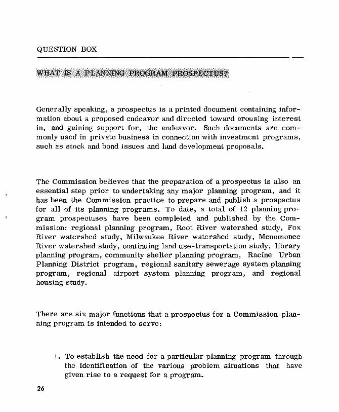
QUESTION BOX
Generally speaking, a prospectus is a printed document containing information about a proposed endeavor and directed toward arousing interest in, and gaining support for, the endeavor. Such documents are commonly used in private business in connection with investment programs, such as stock and bond issues and land development proposals.
The Commission believes that the preparation of a prospectus is also an essential step prior to undertaking any major planning program, and it has been the Commission practice to prepare and publish a prospectus for all of its planning programs. To date, a total of 12 planning program prospectuses have been completed and published by the Commission: regional planning program, Root River watershed study, Fox River watershed study, Milwaukee River watershed study, Menomonee River watershed study, continuing land use-transportation study, library planning program, community shelter planning program, Racine Urban Planning District program, regional sanitary sewerage system planning program, regional airport system planning program, and regional housing study.
There are six major functions that a prospectus for a Commission planning program is intended to serve:
26
1. To establish the need for a particular planning program through the identification of the various problem situations that have given rise to a request for a program.

QUESTION BOX - Continued
2. To outline in detail the main divisions of the work required to be undertaken if the program is mounted. This narrative outline becomes the basis for more detailed study design memoranda prepared during the initial phases of the program. This outline also provides the basis for determining the cost and time schedule for the program.
3. To recommend the most effective method for establishing, organizing, and accomplishing the desired work program. This would include recommendations with respect to study staff, location, and committee structure.
4. To recommend a practical time sequence and schedule for the particular work items.
5. To provide cost data to permit development of an initial program budget and to suggest possible funding of the program.
6. To determine the extent to which the various levels, units, and agencies of government and the various private interests concerned might participate in the conduct of the particular planning program under consideration.
In summary, a prospectus is intended to provide sufficient information to permit the county boards and the various state and federal agencies concerned to consider the needs for, and the benefits and costs of, a CommiSSion-proposed planning program. As a printed document, the prospectus provides a common understanding of the depth and scope of the particular proposed program. It is, in short, a document intended to be used in the making of the critical decision of whether or not to conduct a particular planning program.
27

° OJ
::r
' ::1
\ll
0
.'0
rt
rt(1
)"j
::r'
'1'1
(1)
0
c...
<: :
3 0
;>
H"
::r'
I--'
H
::1
rtH
(1)
"1
M:;:;
'1
X
' ::1
::
,()
OJ
OJ (1)
G)
~'~I~ ~
<
:1--
'(1
)0.
(1)
(1)
::1
::1
(Jl(
)Q()
(1)
:: (
1) (1
) '1
""
:s <:
:; ;s
<'1
-<::; ~
n 0.
<'1
-0.
;:s
-0.
?">
~ r·
0 es
:: ;:
s-;s
!:!
n ;:s
-n
0 0
«>
<'1-
<::;r
r es
::::
:l..
s:~«
>~:S
~;S
$;b:
~0-<'1-«>;S
;S~~
.g
• to
«
>0
o.~
(">
::
:: 0
n?
">
~,::r-~
;:s
0 ~
«> <
::; 0.
es
:: r.
«>
O::
:l..
~§«>
.;:s
-;:s
-;S
rr;:s-
?<
<:O
:::l
.. ~
«>
n r.
:::l
.. §
~
«>
:3
~<::;
<:
«>
0-~ <
'1-:::l
.. 0
-n
«>
s::
~ «> r.
0. r.
es::
r.?"
> n
:::l
.. 0.
•
<'1-
;S
';S
«>
«>
<'1
-O;S;....~tO~:
b: ~~?">
<'1-
0. ~. 0
. 0
;.... n
' 0.
<'1
-«>
«>
;:s
-()
~
:::l..
0.
«> -i"
;:S
-:::l.
.:::l.
. ~
«><:S;:S-~:::l..
;:s-
«>
«>
o ;:s
-("
> ;S
r. ~
«>
:3
rres
::,:
:r
;:s
r.
;:s-~;:s-~
r.·
to
~ b
: ;:S
-;S
0. ~ ~ §
~ ~
b: 0~0.§<::;0«>>-':~
2:0
0
-<
:<:;
S.;
:S-
~:::l..
r·
?">
t:> ~.
("> r.
~ 0
~ •
«>;:
s «>
lii
(">
,::r
<'1-
-;S
.
:::l..
0-<'
1-'.s:
: ~
0 ;:s
-<::;
<:
:; ~
r.es
::
.. ~ r.
rr
$; § ~ ~ ~t
5 :s ~
§ ~ ~ ~
;:s-
0-~ 0
<:
;:s
-~ ::
:l.. r
. <:
n
o (-:
. r.
<:
0. ~ 0
-?-
. k
<'1-
(">
«>
~;;!
t5 ~
'~es:: <
;' g..R~~~ ~
WIS
CO
NS
IN
RE
GIO
NA
L
CO
MM
ISS
ION
urt
ho
use
76
9
Wis
co
nsin
(41
4)
54
7-6
72
1
Bau
er
RE
QU
ES
TE
D
tg ~ O
J r m
tg ~
of
this
pu
bli
cati
on
was
fin
ance
d i
n p
art
th
rou
gh
a c
om
pre
hen
siv
e p
lan
nin
g g
ran
t fr
om
th
e o
f H
ousi
ng a
nd U
rban
Dev
elo
pm
ent
and
thro
ug
h a
S
tate
pla
nn
ing
ass
ista
nce
gra
nt
fro
m
Dep
artm
ent
of
Lo
cal
Aff
airs
an
d D
evel
op
men
t u
nd
er t
he
pro
vis
ion
s of
S
ecti
on
22.
14
of
the
BU
LK
R
AT
E
U.
S.
PO
ST
AG
E
P A
I
D
3 3
/4 ~
WA
UK
ES
HA
, W
IS.
PE
RM
IT
N
O.
64
5