Common Cloud Names, Shapes, and Altitudes:
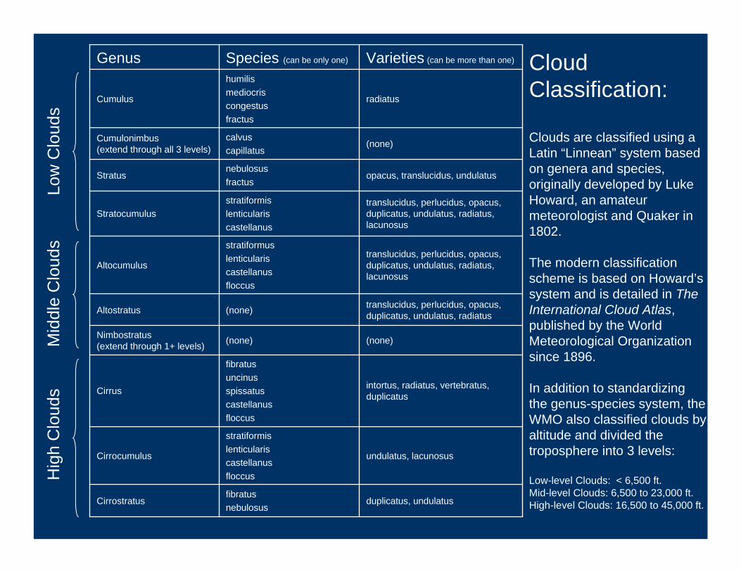
duplicatus, undulatusfibratusnebulosus
Cirrostratus
undulatus, lacunosus
stratiformislenticulariscastellanusfloccus
Cirrocumulus
intortus, radiatus, vertebratus, duplicatus
fibratusuncinusspissatuscastellanusfloccus
Cirrus
(none)(none)Nimbostratus (extend through 1+ levels)
translucidus, perlucidus, opacus, duplicatus, undulatus, radiatus(none)Altostratus
translucidus, perlucidus, opacus, duplicatus, undulatus, radiatus, lacunosus
stratiformuslenticulariscastellanusfloccus
Altocumulus
translucidus, perlucidus, opacus, duplicatus, undulatus, radiatus, lacunosus
stratiformislenticulariscastellanus
Stratocumulus
opacus, translucidus, undulatusnebulosusfractus
Stratus
(none)calvuscapillatus
Cumulonimbus (extend through all 3 levels)
radiatus
humilismediocriscongestusfractus
Cumulus
Varieties (can be more than one)Species (can be only one)GenusLo
w C
loud
sM
iddl
e C
loud
sH
igh
Clo
uds
CloudClassification:
Clouds are classified using a Latin “Linnean” system based on genera and species, originally developed by Luke Howard, an amateur meteorologist and Quaker in 1802.
The modern classification scheme is based on Howard’s system and is detailed in The International Cloud Atlas, published by the World Meteorological Organization since 1896.
In addition to standardizing the genus-species system, the WMO also classified clouds by altitude and divided the troposphere into 3 levels:
Low-level Clouds: < 6,500 ft.Mid-level Clouds: 6,500 to 23,000 ft.High-level Clouds: 16,500 to 45,000 ft.

Cumulus Clouds(“The cloud of choice for 6-yr.-olds”)
Fast Facts:
Typical Altitude: 2,000-3,000 ft.
Location: Worldwide (except in Antartica, where it’s too cold)
Precipitation: Generally none, except for brief showers from congestus
Composition: Liquid water
Formation: Thermal convection currents
There are three species of cumulus clouds:• humilis are wider than they are tall• mediocris are as wide as they are tall• congestus are taller than they are wide
Often called “fair-weather” clouds, cumulus clouds are common over land on sunny days, when the sun heats the land creating thermal convection currents
Each thermal is distinct, and, consequently, each cumulus cloud is a distinct puff

Cumulonimbus Clouds(“The towering thunderclouds that scare us senseless”)
Fast Facts:
Typical Altitude: 2,000-45,000 ft.
Location: Common in tropics and temperate regions, rare at poles
Precipitation: Heavy downpours, hail
Composition: Liquid water throughout, ice crystals at the top
Formation: Upwardly mobile cumulus congestus clouds (thermals)
Three critical conditions for cumulonimbus formation:
• Ready supply of warm, moist air, which rises at speeds of up to 25-70 mph
• Tropospheric winds need to increase considerably with height to encourage it to slant forward
• The atmosphere around the cloud needs to be “unstable” – no temp. inversions here

Stratus Clouds(“The clouds that weigh heavily on your mood”)
Fast Facts:
Typical Altitude: 0-6,500 ft.
Location: Worldwide, but especially common around coasts and mountains
Precipitation: No more than light drizzle
Composition: Liquid water
Formation: Advective or radiative cooling
Stratus clouds are the lowest forming and are often called fog or mists when they are earth-bound
Stratus clouds are formed when a large air mass cools at the same time (e.g. – a warm air parcel drifts into or above a cooler region)

Stratocumulus Clouds(“The low, puffy layers”)
Fast Facts:
Typical Altitude: 2,000-6,500 ft.
Location: Worldwide – very common
Precipitation: Occasional light rain, snow
Composition: Liquid water
Formation: Spreading and joining of cumulus clouds below a temperature inversion, wind turbulence in a stratus layer
Similar to cumulus clouds in form and composition, stratocumulus clouds are textured and puffy, but also joined into a semi-continuous layer
Stratocumulus clouds usually form from cumulus or stratus clouds

Altocumulus Clouds(“Layers of bread rolls”)
Fast Facts:
Typical Altitude: 6,500-18,000 ft.
Location: Worldwide
Precipitation: Very occasional light rain
Composition: Mostly liquid water, may also contain ice crystals
Formation: Mid-level atmospheric disturbances and wave propagation (from e.g. –mountatins)
Since altocumulus clouds are high in the sky, they are generally above the influence of thermals, and form very differently from cumulus and stratocumulus clouds, who share similar names.

Altostratus Clouds(“The boring clouds”)
Fast Facts:
Typical Altitude: 6,500-16,500 ft.
Location: Worldwide, common in middle latitudes
Precipitation: Occasional light rain, snow
Composition: Both liquid water, and ice crystals
Formation: Usually formed from the thickening and lowering of a cirrostratus cloud on its way to becoming a nimbostratus cloud
Below 6,500 ft. it’s stratus
Between 6,500 and 23,000 ft. it’s altostratus
Boring! – but being so high up, they do make for nice sunsets.
Altostratus are potentially dangerous to aircraft because they can cause ice accumulation on the wings.
Altostratus Altocumulus

Nimbostratus Clouds(“Rainy day clouds”)
Fast Facts:
Typical Altitude: 2,000-18,000 ft.
Location: Worldwide, common in middle latitudes
Precipitation: Moderate to heavy rain or snow, which is generally steady and prolonged
Composition: Liquid water, raindrops snowflakes and ice crystals
Formation: Usually formed from the thickening and lowering of a altostratus cloud
The nimbostratus cloud has no species or varieties.It is a thick, wet blanket with a ragged base caused by the continual precipitation

Cirrus Clouds(“Delicate cloud streaks”)
Fast Facts:
Typical Altitude: 16,500-45,000 ft.
Location: Worldwide
Precipitation: None that reaches ground
Composition: Ice crystals
Formation: Fall streaks of ice crystals in upper troposphere winds
Cirrus clouds are the highest of all clouds and are composed entirely of ice crystals.
Cirrus clouds are precipitating clouds, although the ice crystals evaporate high above the earth’s surface.
The crystals, caught in 100-150 mph winds create wisps of cloud.

Cirrocumulus Clouds(“Regularly spaced cloudlets, often rippled”)
Fast Facts:
Typical Altitude: 16,500-45,000 ft.
Location: Worldwide
Precipitation: None that reaches ground
Composition: Ice crystals
Formation: Cloudlets formed by choppy winds and high moisture levels in upper troposphere
Cirrocumulus clouds are usually a transitional phase between cirrus and cirrostratus clouds.
Large numbers of cirrocumulus clouds may indicate poor weather is approaching.

Cirrostratus Clouds(“Delicate cloud streaks”)
Fast Facts:
Typical Altitude: 20,000-42,000 ft.
Location: Worldwide
Precipitation: None
Composition: Ice crystals
Formation: Spreading and joining of cirrus clouds
Cirrostratus clouds are difficult to spot and appear as a pale, milky lightening of the sky.
Cirrostratus clouds never block out the sun completely, but rather produce a variety of optical effects.

Contrails and Others
cirrostratuscirrus
Cumulus
cirruscontrails Kelvin-Helmholtz Wave Clouds
Recommended