Oct 2014 Alberto R. Cunha 1
02
Vehicle to Infrastructure Interaction (V2I)
Alberto Ramos da Cunha
Alberto R. Cunha 2
Plan
Vehicle sensing
• Inductive loop detectors
• Magnetic sensors
• Ultrasound
• Microwave
• Video capture and processing
• Global sensing

Nov 2007 Alberto R. Cunha 3
Sensors
• Devices that detect or measure a physical property,
or its variation, an convert it on an electrical signal
which can be automatically processed
• The following sensing devices and equipments do
not require vehicle cooperation, the detect vehicles
as they move by

Alberto R. Cunha 4
Inductive loop detectors• Most common vehicle sensor
• Detects the inductance change
when a vehicle passes over a coil
• Several physical configurations
area able to support diverse
applications– Counting
– Speed measurement
– Vehicle classification
© US Department of Transportation – FHWA
Alberto R. Cunha 5
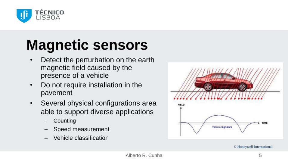
Magnetic sensors• Detect the perturbation on the earth
magnetic field caused by the presence of a vehicle
• Do not require installation in the pavement
• Several physical configurations area
able to support diverse applications– Counting
– Speed measurement
– Vehicle classification
© Honeywell International

Alberto R. Cunha 6
Ultrasound sensors• Detects the reflected ultrasonic
wave (25-50 kHz)
• Several physical configurations
area able to support diverse
applications– Counting
– Speed measurement (Doppler
effect)
– Presence/Occupation
© Microwave Sensors, Ann Arbor, MI; US Department of
Transportation – FHWA

Event processing
Sensed signals are processed to generate events
For two ILD sensors in the same lane d metres apart:
time (sensor, event) function returns the time of the event on a sensor
speed = d / [time(ILD1, ON) – time(ILD2, ON)]
length = speed x [time(ILD1, ON) – time(ILD1, OFF)]
11/6/2014 Instituto Superior Técnico

Alberto R. Cunha 8
Microwave radars• Detect echos from microwave bursts
(1-30 GHz)
• Constant frequency Doppler radar– Evaluates speed from the difference between the
emission frequency and the echo frequency
• Modulated frequency radar– Speed
– Presence
– Classificaton
© US Department of Transportation – FHWA
Alberto R. Cunha 9
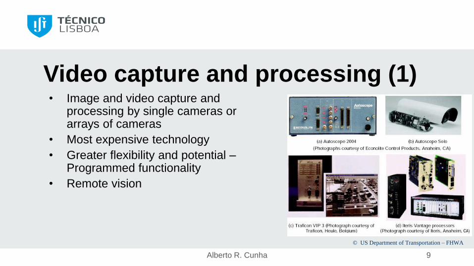
Video capture and processing (1)• Image and video capture and
processing by single cameras or arrays of cameras
• Most expensive technology
• Greater flexibility and potential –Programmed functionality
• Remote vision
© US Department of Transportation – FHWA

Alberto R. Cunha 10
Video capture and processing (2)• Diverse algorithms support many
applications– Counting
– Speed measurement
– Vehicle classification
– Vehicle identificaton, license plate recognition
Ex: HI-TEC solutions
– Legal enforcement• Access control to restricted zones
• Unauthorised parking
• Unauthorised circulation
© Lawrence Klein – Sensor Technologies and Data Requirements for ITS. Artech
House.
Alberto R. Cunha 11
Other sensorsRoadside:
• Passive Acoustic Arrays
• Infrared passive sensors
• Laser sensors
• Toll gantries
Global sensing:
• Celular networs
• Satellite positioning systems
Require an
identifier or some
form of terminal
equipment in the
vehicle
Alberto R. Cunha 12
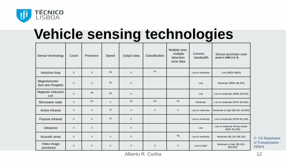
Vehicle sensing technologies
Sensor technology Count Presence Speed Output data Classification
Multiple lane,
multiple
detection
zone data
Comms.
bandwidthSensor purchase costa
(each in 1999 U.S. $)
Inductive loop X X Xb X XcLow to moderate Lowi ($500–$800)
Magnetometer
(two axis fluxgate)X X Xb X Low Moderatei ($900–$6,300)
Magnetic induction
coilX Xd Xb X Low Low to moderatei ($385–$2,000)
Microwave radar X Xe X Xe Xe XeModerate Low to moderate ($700–$2,000)
Active infrared X X Xf X X X Low to moderate Moderate to high ($6,500–$3,300)
Passive infrared X X Xf X Low to moderate Low to moderate ($700–$1,200)
Ultrasonic X X X LowLow to moderate (Pulse model:
$600–$1,900)
Acoustic array X X X X XgLow to moderate Moderate ($3,100–$8,100)
Video image
processorX X X X X X Low to highh
Moderate to high ($5,000–
$26,000)
© US Department
of Transportation –
FHWA

Alberto R. Cunha 13
Toll gantries• Reuse existing infrastructures
for road tolling
© Lawrence Klein – Sensor Technologies and
Data Requirements for ITS. Artech House.
Alberto R. Cunha 14
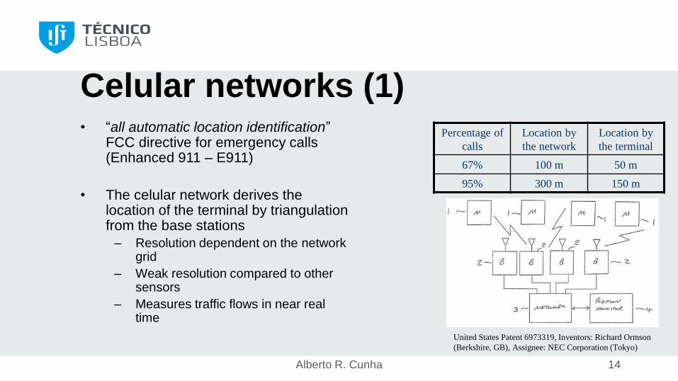
Celular networks (1)• “all automatic location identification”
FCC directive for emergency calls (Enhanced 911 – E911)
• The celular network derives the location of the terminal by triangulation from the base stations
– Resolution dependent on the network grid
– Weak resolution compared to other sensors
– Measures traffic flows in near real time
Percentage of
calls
Location by
the network
Location by
the terminal
67% 100 m 50 m
95% 300 m 150 m
United States Patent 6973319, Inventors: Richard Ormson
(Berkshire, GB), Assignee: NEC Corporation (Tokyo)
Alberto R. Cunha 15
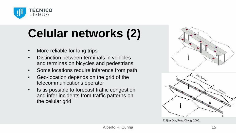
Celular networks (2)
• More reliable for long trips
• Distinction between terminals in vehicles and terminas on bicycles and pedestrians
• Some locations require inference from path
• Geo-location depends on the grid of the telecommunications operator
• Is tis possible to forecast traffic congestion and infer incidents from traffic patterns on the celular grid
Zhijun Qiu, Peng Cheng. 2006.
Alberto R. Cunha 16
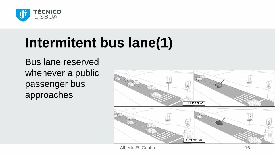
Intermitent bus lane(1)
Bus lane reserved
whenever a public
passenger bus
approaches
Alberto R. Cunha 17
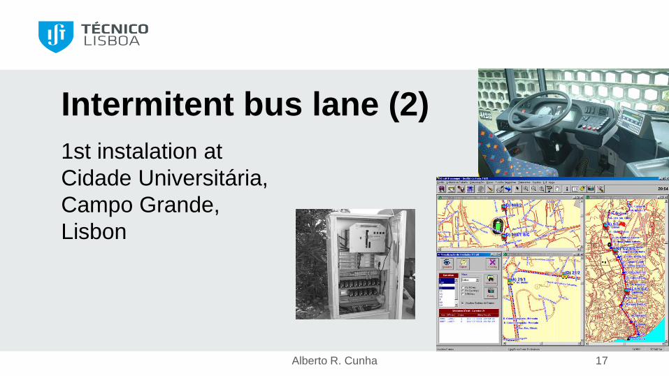
Intermitent bus lane (2)
1st instalation at
Cidade Universitária,
Campo Grande,
Lisbon
Nov 2007 Alberto R. Cunha 18
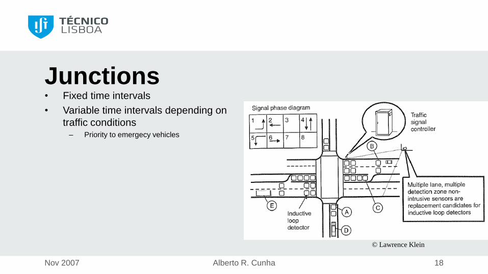
Junctions• Fixed time intervals
• Variable time intervals depending on
traffic conditions– Priority to emergecy vehicles
© Lawrence Klein
Alberto R. Cunha 19
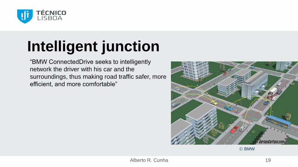
Intelligent junction“BMW ConnectedDrive seeks to intelligently
network the driver with his car and the
surroundings, thus making road traffic safer, more
efficient, and more comfortable”
BMW

Alberto R. Cunha 20
Traffic managementCaptura e funde os dados dos vários sensores e
comanda os semáforos à escala global
Lisbon Gertrude (Gestion Electronique de Règulation en
Temps Réel pour L’Urbanisme, les Déplacements et l’Environnement)

Alberto R. Cunha 21
References• Sensor Technologies and Data Requirements for ITS.
Lawrence A. Klein. Artech House. 2001.
• Traffic Detector Handbook: Third Edition – Volume I. Federal
Highway Administration, US Dep. of Transportation, October
2006.
Recommended