
1
© 2012 Oracle Corporation

<Insert Picture Here>
Map Views in Oracle Business Intelligence Enterprise Edition, 11g
Abhinav Agarwal Director, Prod. Mgmt., OBIEE
Jayant Sharma Director, Prod. Mgmt., Oracle Spatial
3
© 2012 Oracle Corporation
THE FOLLOWING IS INTENDED TO OUTLINE OUR
GENERAL PRODUCT DIRECTION. IT IS INTENDED
FOR INFORMATION PURPOSES ONLY, AND MAY
NOT BE INCORPORATED INTO ANY CONTRACT.
IT IS NOT A COMMITMENT TO DELIVER ANY
MATERIAL, CODE, OR FUNCTIONALITY, AND
SHOULD NOT BE RELIED UPON IN MAKING
PURCHASING DECISION. THE DEVELOPMENT,
RELEASE, AND TIMING OF ANY FEATURES OR
FUNCTIONALITY DESCRIBED FOR ORACLE'S
PRODUCTS REMAINS AT THE SOLE DISCRETION
OF ORACLE.
4
© 2012 Oracle Corporation
<Insert Picture Here>
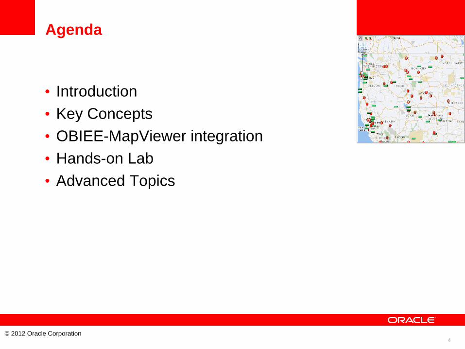
Agenda
• Introduction
• Key Concepts
• OBIEE-MapViewer integration
• Hands-on Lab
• Advanced Topics

5
© 2012 Oracle Corporation
INTRODUCTION

6
© 2012 Oracle Corporation
KEY CONCEPTS
7
© 2012 Oracle Corporation
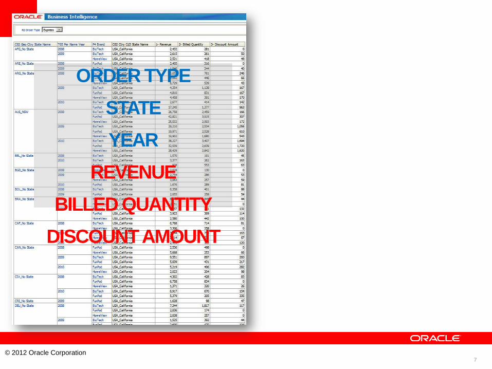
ORDER TYPE
STATE
YEAR
REVENUE
BILLED QUANTITY
DISCOUNT AMOUNT

8
© 2012 Oracle Corporation
State Year Revenue
Year Brand Order Type Revenue
Brand Year Billed Quantity Brand Year Revenue Brand Year Discount Amt
9
© 2012 Oracle Corporation
When are Map views useful
• Visualizing data related to geographic locations.
• Showing lots of data in a relatively small area.
• Showing or detecting spatial relationships and
patterns.
• Drilling down from a (map) overview to a detailed
report, chart, or graph.
10
© 2012 Oracle Corporation
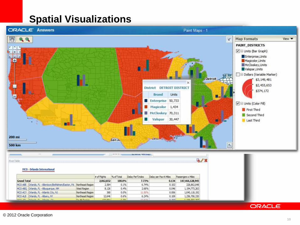
Spatial Visualizations

11
© 2012 Oracle Corporation
Spatial Visualizations
Interactive; choice of binning options, styles, & formats
Detect trends not visible with traditional visualizations
Visualize non-standard geographies
Multi-format, mulit-measure, multi-grain interactive visualizations
Floor-plans also
12
© 2012 Oracle Corporation
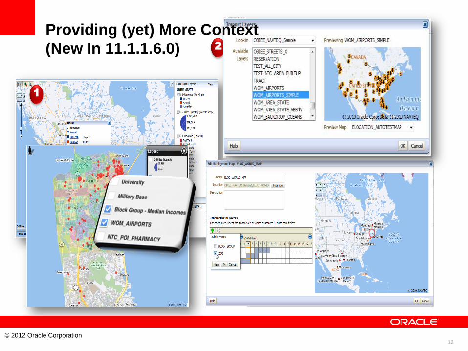
• Spatial Feature
Themes
1
2
Providing (yet) More Context
(New In 11.1.1.6.0)
13
© 2012 Oracle Corporation
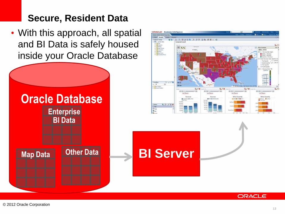
Secure, Resident Data
• With this approach, all spatial
and BI Data is safely housed
inside your Oracle Database
Map Data
Oracle Database
BI Server
Other Data
Enterprise BI Data

14
© 2012 Oracle Corporation
OBIEE – MAPVIEWER
INTEGRATION
15
© 2012 Oracle Corporation
What is Spatial Data?
• Business data that contains or describes location
– Geographic features (roads, rivers, parks, etc.)
– Assets (cell tower, fire hydrant, electrical transformer, etc.)
– Sales data (sales territory, customer registration, etc.)
– Street and postal address (customers, stores, factory, etc.)
• Anything connected to a physical location
• Almost every database contains some form of
business data that can be leveraged using spatial
technologies
• Location is a “universal key”
16
© 2012 Oracle Corporation
What Spatial Data do you need ?
• Business Data
– This is the data you need in order to show the results of your
BI queries
– For example: country boundaries, states, provinces, postal
code areas, etc.
• Background Data
– This is used to build maps on which the business data is
displayed
– Roads, rivers, forests, buildings, etc
– Could also be from satellite or aerial photos.
– Not always required
– Provides context for the business data
17
© 2012 Oracle Corporation
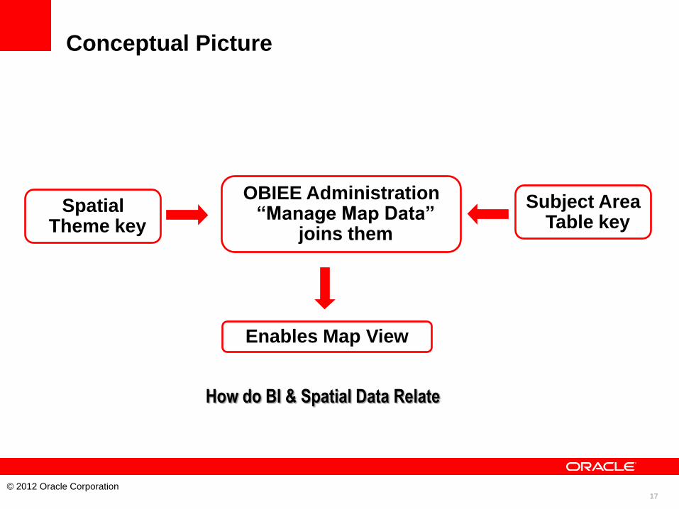
Conceptual Picture
How do BI & Spatial Data Relate
Spatial Theme key
Subject Area Table key
OBIEE Administration “Manage Map Data”
joins them
Enables Map View
18
© 2012 Oracle Corporation
Background Maps
• Internal
– MapViewer renders spatial data stored in Oracle
• External (3rd party map tile servers)
– Oracle Maps (free)
– NAVTEQ Maps (requires license)
– Google Maps (requires license)
– Others (may require license, planned for future release)
This document is for informational purposes only and may not be incorporated into a contract or agreement.
19
© 2012 Oracle Corporation
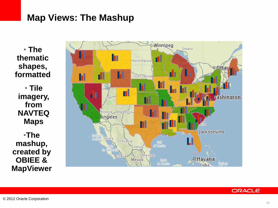
Map Views: The Mashup
• The thematic shapes,
formatted
• Tile imagery,
from NAVTEQ
Maps
•The mashup,
created by OBIEE &
MapViewer

20
© 2012 Oracle Corporation
Functional Picture
MapBuilder Spatial Theme Admin tool - BI Data
BI EE: Manage Map Data
BI Answers Map View
21
© 2012 Oracle Corporation
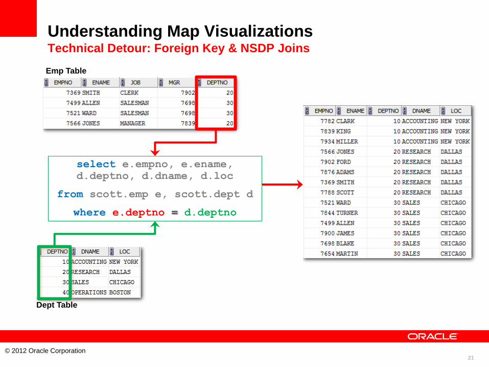
Understanding Map Visualizations Technical Detour: Foreign Key & NSDP Joins
select e.empno, e.ename,
d.deptno, d.dname, d.loc
from scott.emp e, scott.dept d
where e.deptno = d.deptno
Emp Table
Dept Table
22
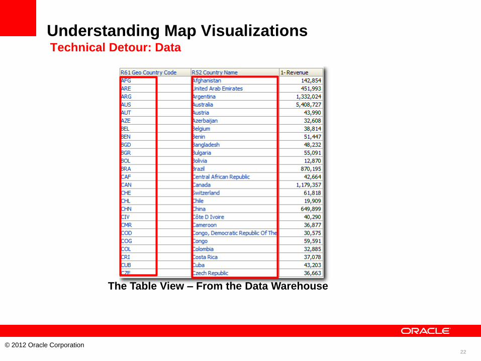
© 2012 Oracle Corporation
Understanding Map Visualizations Technical Detour: Data
The Table View – From the Data Warehouse
23
© 2012 Oracle Corporation
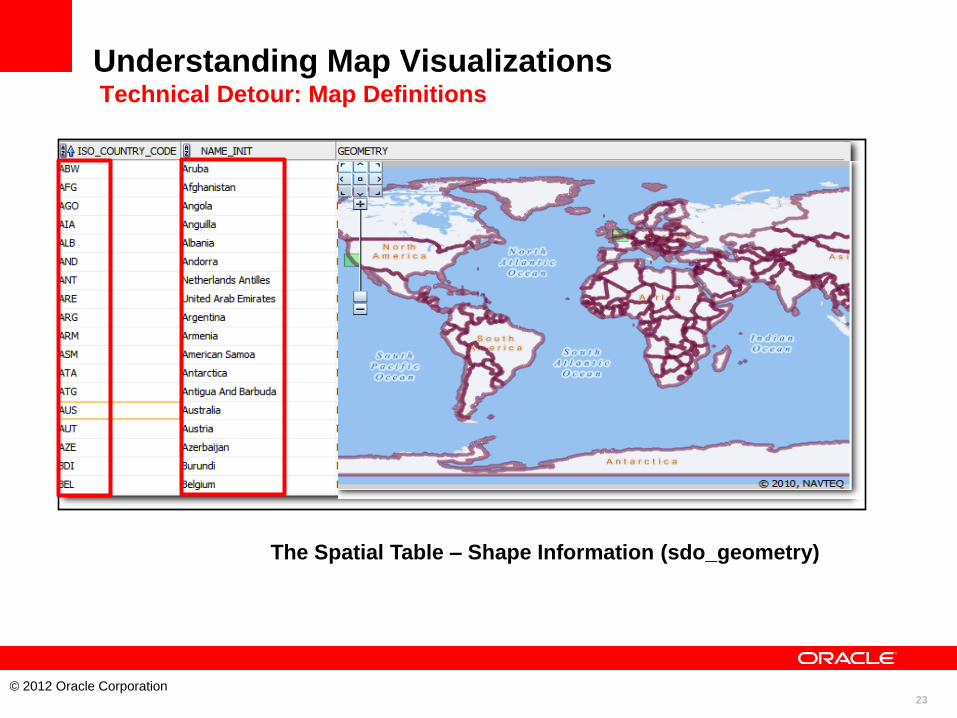
Understanding Map Visualizations Technical Detour: Map Definitions
The Spatial Table – Shape Information (sdo_geometry)
24
© 2012 Oracle Corporation
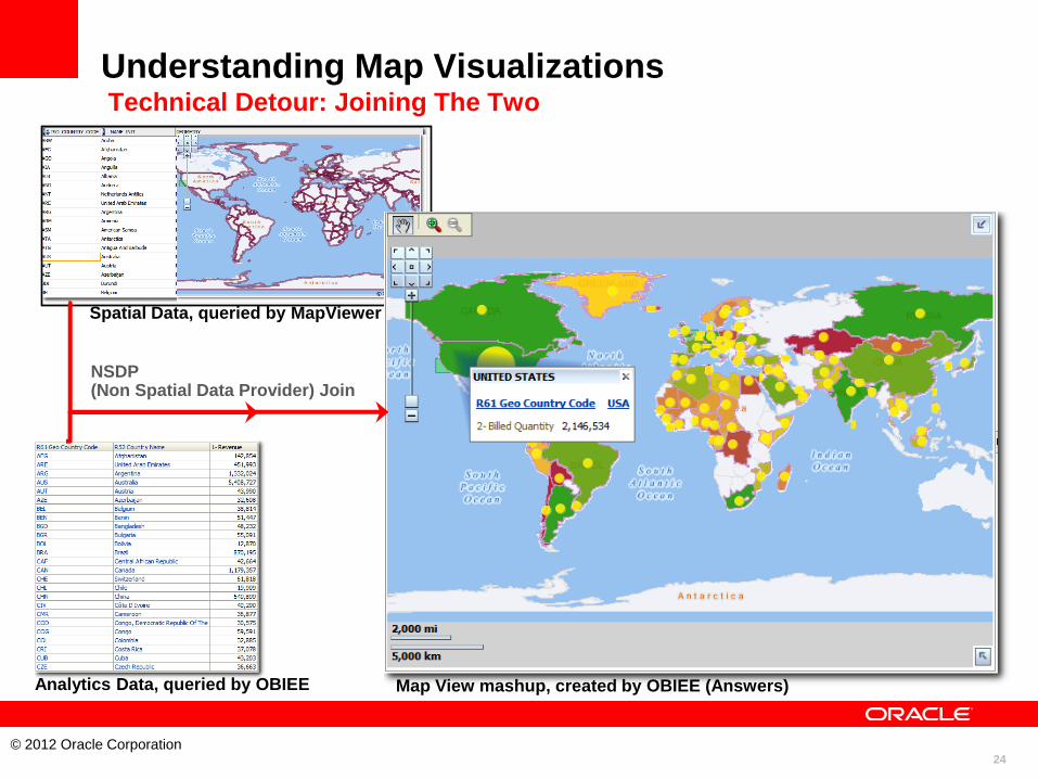
Understanding Map Visualizations Technical Detour: Joining The Two
NSDP (Non Spatial Data Provider) Join
Spatial Data, queried by MapViewer
Analytics Data, queried by OBIEE Map View mashup, created by OBIEE (Answers)
25
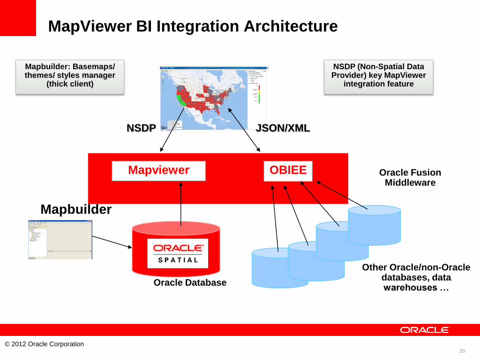
© 2012 Oracle Corporation
OBIEE Mapviewer
Oracle Database
NSDP
Other Oracle/non-Oracle databases, data warehouses …
NSDP (Non-Spatial Data Provider) key MapViewer
integration feature
Oracle Fusion Middleware
MapViewer BI Integration Architecture
Mapbuilder
Mapbuilder: Basemaps/ themes/ styles manager
(thick client)
JSON/XML
26
© 2012 Oracle Corporation
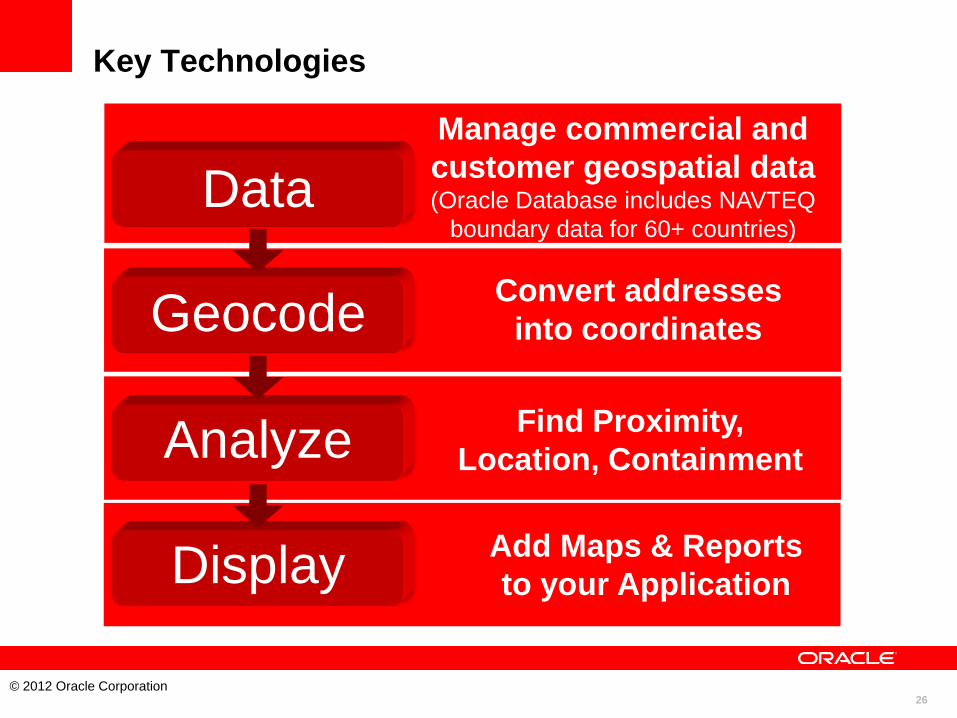
Data
Geocode
Analyze
Display Add Maps & Reports
to your Application
Manage commercial and
customer geospatial data (Oracle Database includes NAVTEQ
boundary data for 60+ countries)
Find Proximity,
Location, Containment
Convert addresses
into coordinates
Key Technologies
27
© 2012 Oracle Corporation
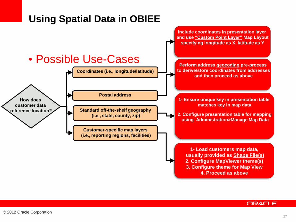
1- Load customers map data,
usually provided as Shape File(s)
2. Configure MapViewer theme(s)
3. Configure theme for Map View
4. Proceed as above
Coordinates (i.e., longitude/latitude)
How does
customer data
reference location?
Postal address
Standard off-the-shelf geography
(i.e., state, county, zip)
Customer-specific map layers
(i.e., reporting regions, facilities)
Include coordinates in presentation layer
and use “Custom Point Layer” Map Layout
specifying longitude as X, latitude as Y
Perform address geocoding pre-process
to derive/store coordinates from addresses
and then proceed as above
1- Ensure unique key in presentation table
matches key in map data
2. Configure presentation table for mapping
using Administration>Manage Map Data
Using Spatial Data in OBIEE
• Possible Use-Cases

28
© 2012 Oracle Corporation
HANDS-ON LAB
29
© 2012 Oracle Corporation
Hands-on Lab
• Create a simple analysis with a map view
• Add charts to the map view
• Master-Detail lining via map views
• Action Links in map views
• Additional material
– Distance queries
– Geocoding
– 3rd party map services
– Full example (import data, create layers, create map views)
30
© 2012 Oracle Corporation
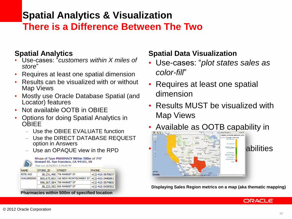
Spatial Analytics & Visualization
Spatial Analytics • Use-cases: “customers within X miles of
store”
• Requires at least one spatial dimension
• Results can be visualized with or without Map Views
• Mostly use Oracle Database Spatial (and Locator) features
• Not available OOTB in OBIEE
• Options for doing Spatial Analytics in OBIEE – Use the OBIEE EVALUATE function
– Use the DIRECT DATABASE REQUEST option in Answers
– Use an OPAQUE view in the RPD
Spatial Data Visualization
• Use-cases: “plot states sales as
color-fill”
• Requires at least one spatial
dimension
• Results MUST be visualized with
Map Views
• Available as OOTB capability in
OBIEE (11g)
• Require only Locator capabilities
(with minor exceptions)
Displaying Sales Region metrics on a map (aka thematic mapping)
There is a Difference Between The Two
Pharmacies within 500m of specified location

31
© 2012 Oracle Corporation
Spatial Analytics Example 1 People Living Within Distance of Store Type
• Population
Information
(by census
blocks) on
people living
within
distance of
specified
Store Type
• Requires Spatial analytic function (sdo_within_distance)
• Combines non-BI data (population information)
32
© 2012 Oracle Corporation
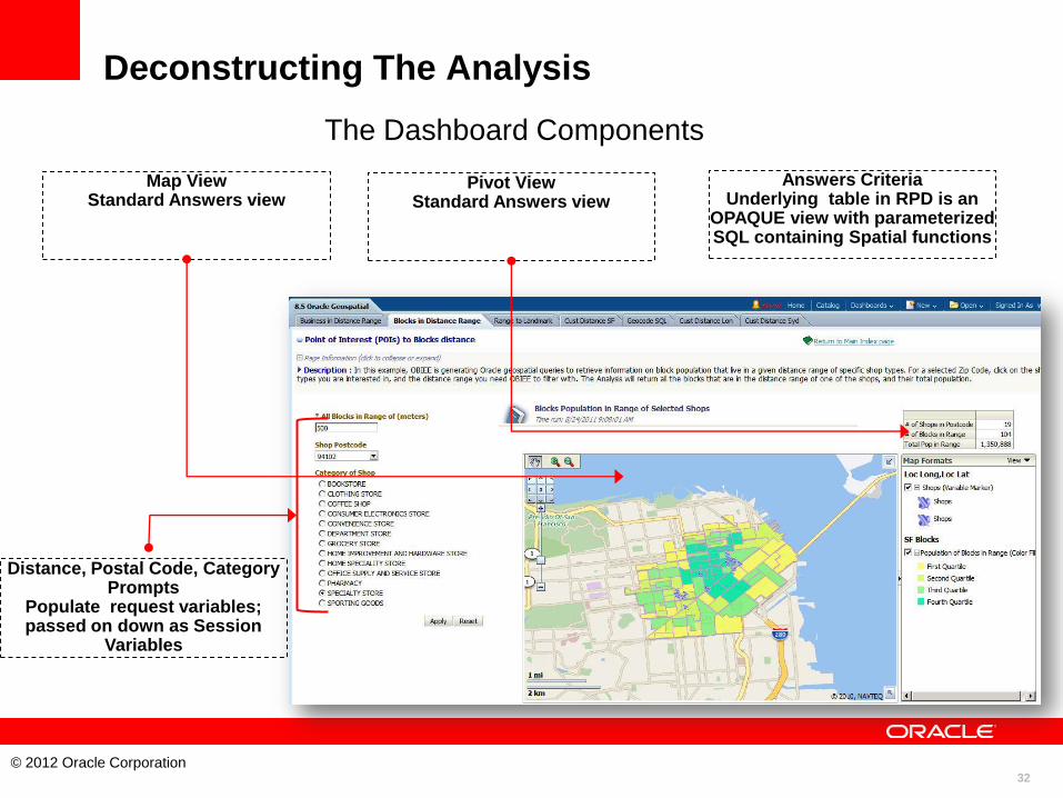
Deconstructing The Analysis
The Dashboard Components
Map View Standard Answers view
Distance, Postal Code, Category Prompts
Populate request variables; passed on down as Session
Variables
Pivot View Standard Answers view
Answers Criteria Underlying table in RPD is an
OPAQUE view with parameterized SQL containing Spatial functions
33
© 2012 Oracle Corporation
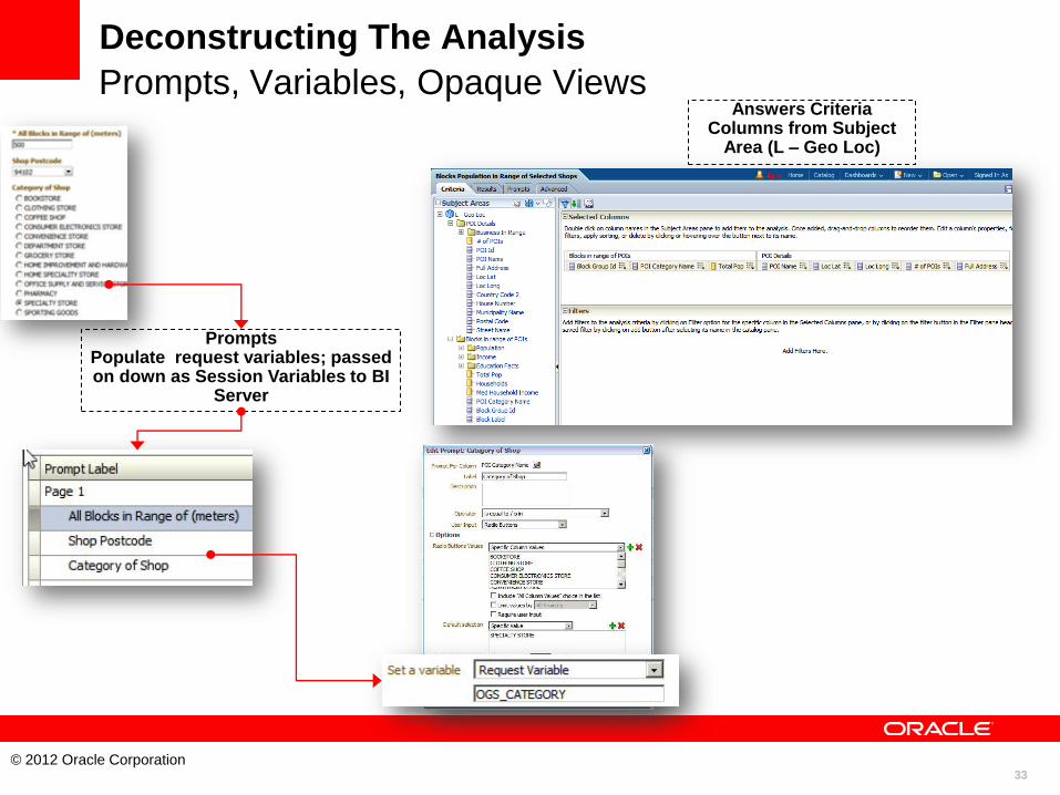
Deconstructing The Analysis
Prompts, Variables, Opaque Views
Prompts Populate request variables; passed on down as Session Variables to BI
Server
Answers Criteria Columns from Subject
Area (L – Geo Loc)
34
© 2012 Oracle Corporation
Deconstructing The Analysis
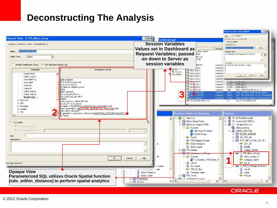
• Constructing The Spatial SQL In An Opaque View
Session Variables Values set in Dashboard as Request Variables; passed
on down to Server as session variables
Opaque View Parameterized SQL utilizes Oracle Spatial function (sdo_within_distance) to perform spatial analytics
1
2
3
35
© 2012 Oracle Corporation
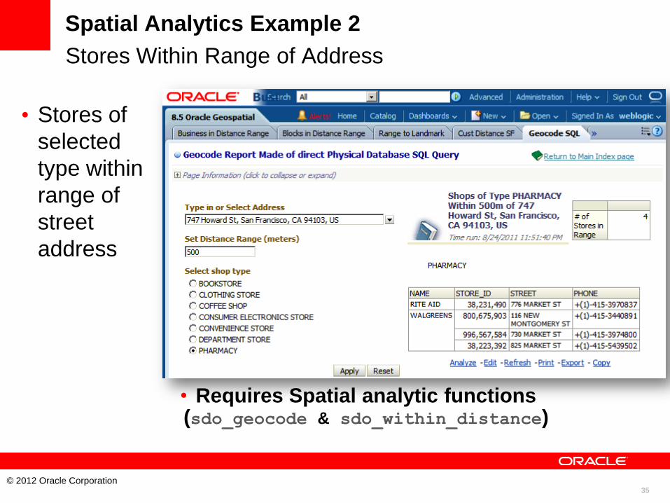
Spatial Analytics Example 2
Stores Within Range of Address
• Stores of
selected
type within
range of
street
address
• Requires Spatial analytic functions (sdo_geocode & sdo_within_distance)
36
© 2012 Oracle Corporation
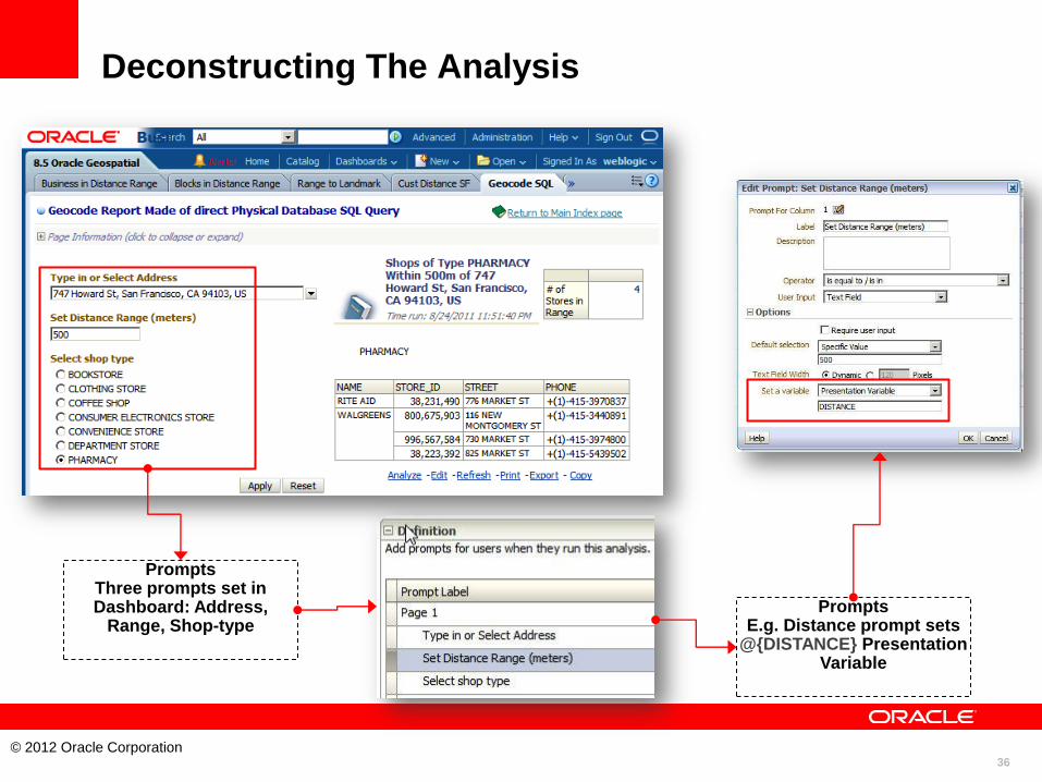
Deconstructing The Analysis
• Setting Presentation
Variables from
Prompts
Prompts Three prompts set in Dashboard: Address,
Range, Shop-type Prompts
E.g. Distance prompt sets @{DISTANCE} Presentation
Variable
37
© 2012 Oracle Corporation
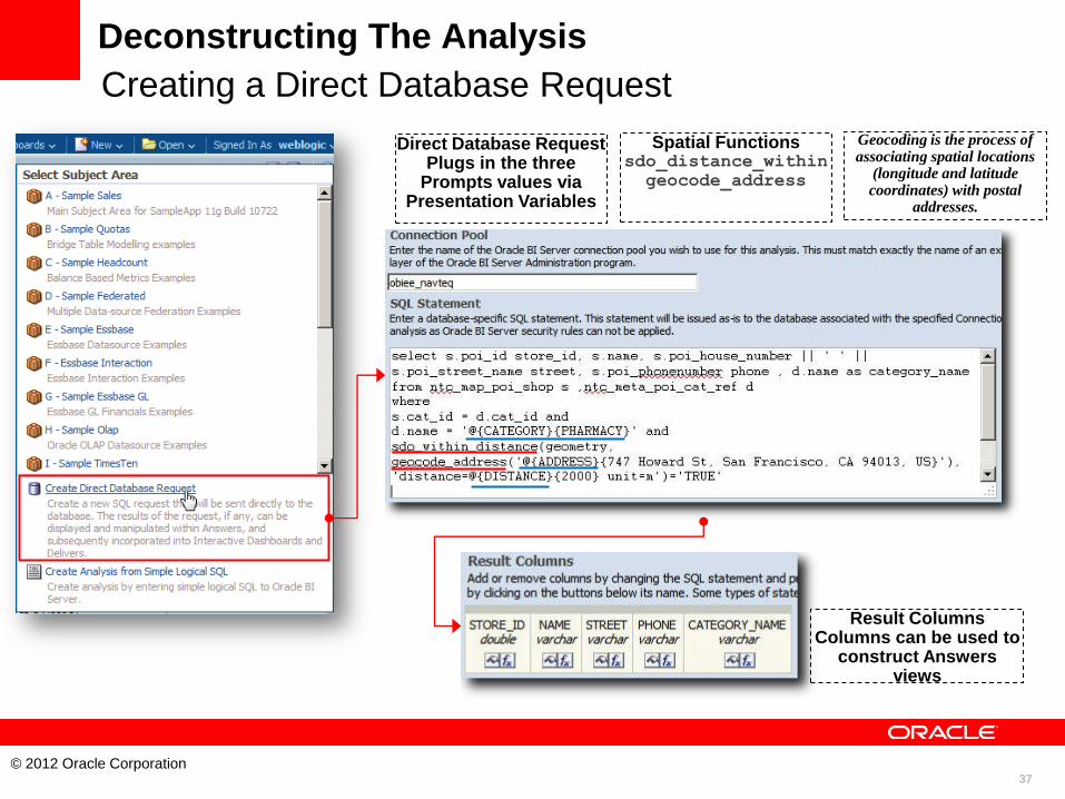
Deconstructing The Analysis
Creating a Direct Database Request
Direct Database Request Plugs in the three
Prompts values via Presentation Variables
Spatial Functions sdo_distance_within
geocode_address
Result Columns Columns can be used to
construct Answers views
Geocoding is the process of associating spatial locations
(longitude and latitude coordinates) with postal
addresses.
38
© 2012 Oracle Corporation
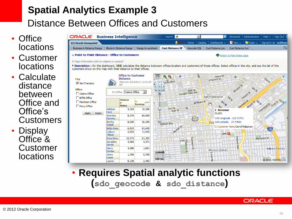
Spatial Analytics Example 3
Distance Between Offices and Customers
• Office locations
• Customer locations
• Calculate distance between Office and Office’s Customers
• Display Office & Customer locations
• Requires Spatial analytic functions (sdo_geocode & sdo_distance)
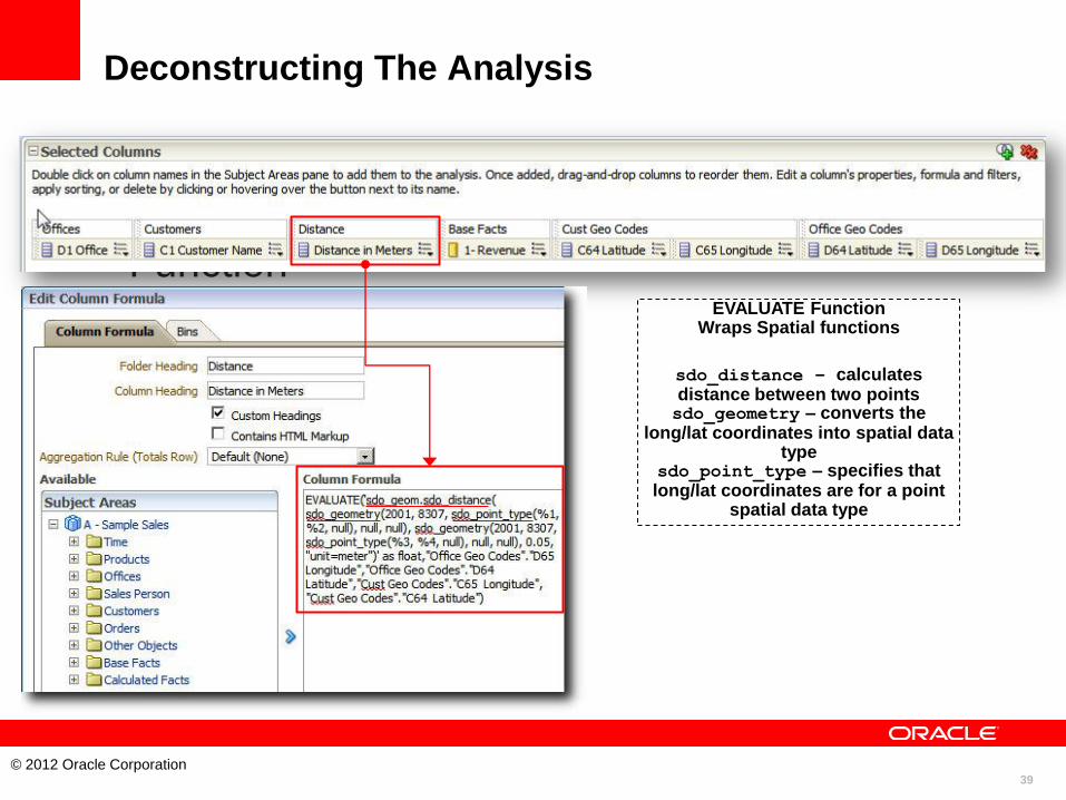
39
© 2012 Oracle Corporation
Deconstructing The Analysis
• Using the EVALUATE
Function EVALUATE Function
Wraps Spatial functions
sdo_distance – calculates distance between two points sdo_geometry – converts the
long/lat coordinates into spatial data type
sdo_point_type – specifies that long/lat coordinates are for a point
spatial data type
40
© 2012 Oracle Corporation
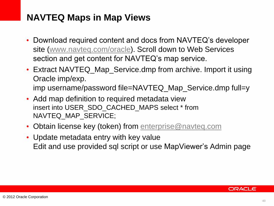
NAVTEQ Maps in Map Views
• Download required content and docs from NAVTEQ’s developer
site (www.navteq.com/oracle). Scroll down to Web Services
section and get content for NAVTEQ’s map service.
• Extract NAVTEQ_Map_Service.dmp from archive. Import it using
Oracle imp/exp.
imp username/password file=NAVTEQ_Map_Service.dmp full=y
• Add map definition to required metadata view insert into USER_SDO_CACHED_MAPS select * from
NAVTEQ_MAP_SERVICE;
• Obtain license key (token) from [email protected]
• Update metadata entry with key value
Edit and use provided sql script or use MapViewer’s Admin page

41
© 2012 Oracle Corporation
NAVTEQ Maps in Map Views
• Use in OBIEE once the map service is configured in MapViewer

42
© 2012 Oracle Corporation

43
© 2012 Oracle Corporation
44
© 2012 Oracle Corporation
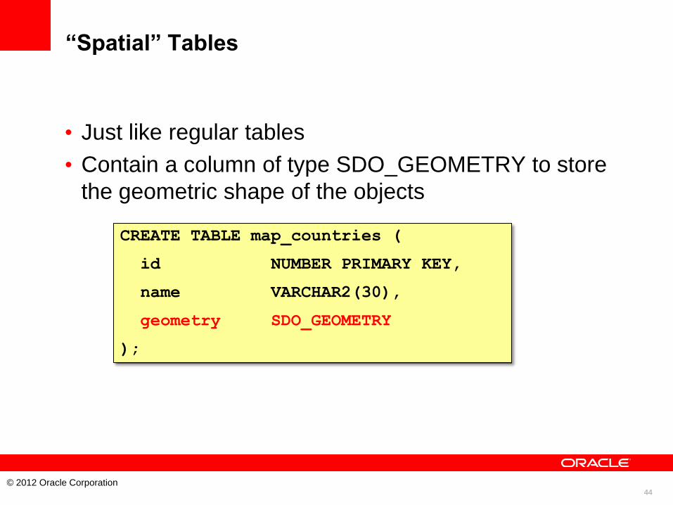
“Spatial” Tables
• Just like regular tables
• Contain a column of type SDO_GEOMETRY to store
the geometric shape of the objects
CREATE TABLE map_countries (
id NUMBER PRIMARY KEY,
name VARCHAR2(30),
geometry SDO_GEOMETRY
);
45
© 2012 Oracle Corporation
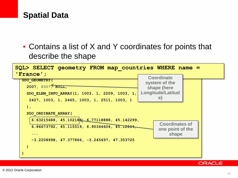
Spatial Data
• Contains a list of X and Y coordinates for points that
describe the shape
SDO_GEOMETRY(
2007, 8307, NULL,
SDO_ELEM_INFO_ARRAY(1, 1003, 1, 2209, 1003, 1,
2427, 1003, 1, 2465, 1003, 1, 2511, 1003, 1
),
SDO_ORDINATE_ARRAY(
6.63215688, 45.102186, 6.77118888, 45.142299,
6.86673792, 45.115519, 6.90344604, 45.12864,
...
-3.2208998, 47.377866, -3.245697, 47.353725
)
)
SQL> SELECT geometry FROM map_countries WHERE name =
'France'; Coordinate
system of the shape (here
Longitude/Latitude)
Coordinates of one point of the
shape
46
© 2012 Oracle Corporation
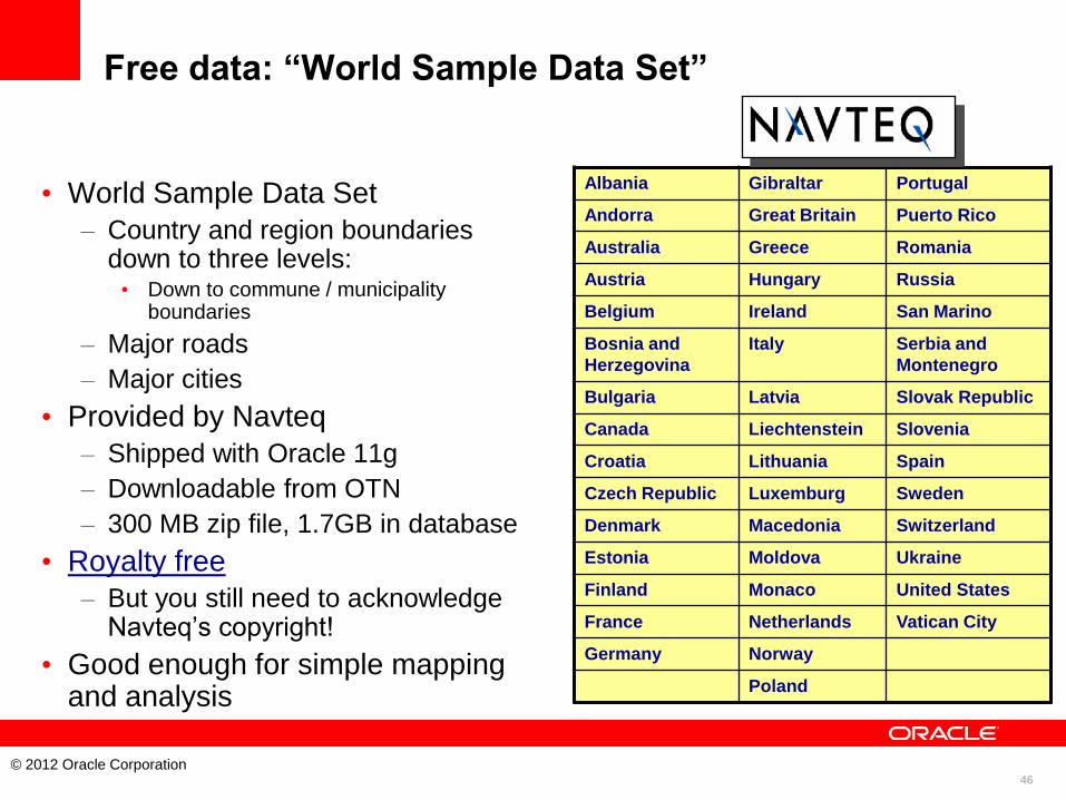
Free data: “World Sample Data Set”
• World Sample Data Set
– Country and region boundaries down to three levels: • Down to commune / municipality
boundaries
– Major roads
– Major cities
• Provided by Navteq
– Shipped with Oracle 11g
– Downloadable from OTN
– 300 MB zip file, 1.7GB in database
• Royalty free
– But you still need to acknowledge Navteq’s copyright!
• Good enough for simple mapping and analysis
Albania Gibraltar Portugal
Andorra Great Britain Puerto Rico
Australia Greece Romania
Austria Hungary Russia
Belgium Ireland San Marino
Bosnia and
Herzegovina
Italy Serbia and
Montenegro
Bulgaria Latvia Slovak Republic
Canada Liechtenstein Slovenia
Croatia Lithuania Spain
Czech Republic Luxemburg Sweden
Denmark Macedonia Switzerland
Estonia Moldova Ukraine
Finland Monaco United States
France Netherlands Vatican City
Germany Norway
Poland
47
© 2012 Oracle Corporation
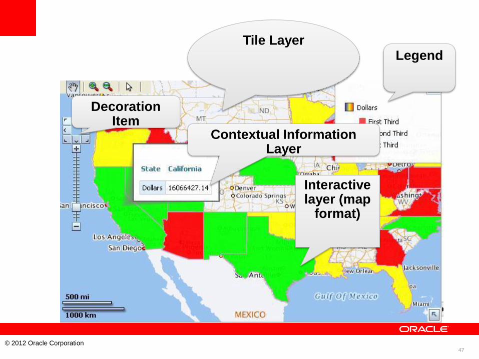
Tile Layer
Interactive layer (map
format)
Contextual Information Layer
Legend
Decoration Item

48
© 2012 Oracle Corporation
Spatial is a Natural BI Component IDC recognized BI sector.
Recommended