Joming Lau Virginia Werner
A Survey of Unreinforced Masonry Buildings in the Admiral Neighborhood of West Seattle
Digital Design PracticumSpring 2011

1
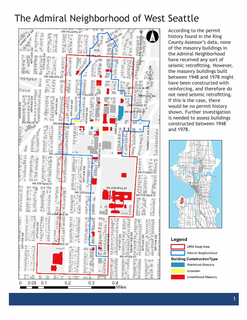
The Admiral Neighborhood of West SeattleAccording to the permit history found in the King County Assessor’s data, none of the masonry buildings in the Admiral Neighborhood have received any sort of seismic retrofitting. However, the masonry buildings built between 1948 and 1978 might have been constructed with reinforcing, and therefore do not need seismic retrofitting. If this is the case, there would be no permit history shown. Further investigation is needed to assess buildings constructed between 1948 and 1978.
2
Historic Significance of Masonry Buildings
45TH
AVE
SW
46TH
AVE
SW
CAL
IFO
RN
IA A
VE
SW
47TH
AVE
SW SW HILL ST
39TH
AVE
SW
48TH
AVE
SW
WAL
NU
T AV
E S
W
44TH
AVE
SW
SW HANFORD ST
SW ADMIRAL WAY
SW LANDER ST
SW WALKER ST
SW HINDS ST
FAIR
MO
UN
T AV
E S
W
SW COLLEGE ST
42N
D A
VE S
W
SW HOLGATE ST
41ST
AV
E S
W
40TH
AVE
SW
SW STEVENS ST
FERRY
AVE S
W
49TH
AVE
SW
SW WAITE ST
SUNSET AVE S
W
SW FOREST ST
ARC
H P
L SW
SW PRINCE ST
WAL
NU
T AV
SW
AC
CE
SS R
D
ARCH AVE SW
SW GRAYSON ST48TH
AVE
SW
44TH
AVE
SW
47TH
AVE
SW
48TH
AVE
SW
42N
D A
VE S
W
SW STEVENS ST
FERRY AVE SW
41ST
AV
E S
W
SW HINDS ST
SW COLLEGE ST
SW STEVENS ST
SW STEVENS ST
LegendURM Study Area
Admiral Neighborhood
Historic Masonry Buildings
Masonry Buildings
0 0.1 0.2 0.3 0.40.05Miles
°45
TH A
VE S
W
46TH
AVE
SW
CAL
IFO
RN
IA A
VE
SW
47TH
AVE
SW SW HILL ST
39TH
AVE
SW
48TH
AVE
SW
WAL
NU
T AV
E S
W
44TH
AVE
SW
SW HANFORD ST
SW ADMIRAL WAY
SW LANDER ST
SW WALKER ST
SW HINDS ST
FAIR
MO
UN
T AV
E S
W
SW COLLEGE ST
42N
D A
VE S
W
SW HOLGATE ST
41ST
AV
E S
W
40TH
AVE
SW
SW STEVENS ST
FERRY
AVE S
W
49TH
AVE
SW
SW WAITE ST
SUNSET AVE S
W
SW FOREST STAR
CH
PL
SW
SW PRINCE ST
WAL
NU
T AV
SW
AC
CE
SS R
D
ARCH AVE SW
SW GRAYSON ST48TH
AVE
SW
44TH
AVE
SW
47TH
AVE
SW
48TH
AVE
SW
42N
D A
VE S
W
SW STEVENS ST
FERRY AVE SW
41ST
AV
E S
W
SW HINDS ST
SW COLLEGE ST
SW STEVENS ST
SW STEVENS ST
LegendURM Study Area
Admiral Neighborhood
Historic Masonry Buildings
Masonry Buildings
0 0.1 0.2 0.3 0.40.05Miles
°
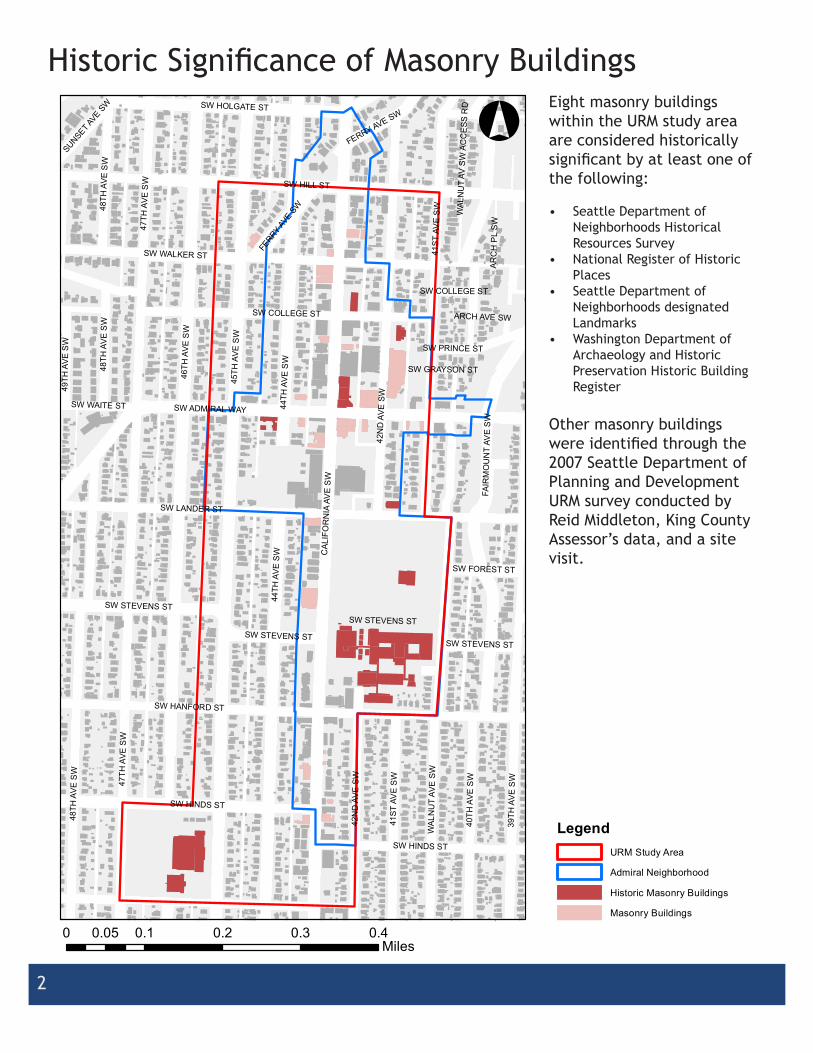
Eight masonry buildings within the URM study area are considered historically significant by at least one of the following:
• Seattle Department of Neighborhoods Historical Resources Survey
• National Register of Historic Places
• Seattle Department of Neighborhoods designated Landmarks
• Washington Department of Archaeology and Historic Preservation Historic Building Register
Other masonry buildings were identified through the 2007 Seattle Department of Planning and Development URM survey conducted by Reid Middleton, King County Assessor’s data, and a site visit.
3
Heartland Cafe
MethodologyStarting with data from the King County Department of Assessments database, a filtered list was created of masonry buildings (construction class 3) in zipcodes 98116 and 98126, which make up the Admiral neighborhood. These buildings were then geocoded using batchgeo.com and manually adjusted to match the boundary of our study area. These buildings were next sorted by the year built column, and divided into three categories describing their time of construction (before 1948, 1948-1978, and after 1978). Masonry buildings constructed before 1948 were most often unreinforced, and these buildings in our study area were assumed to be URM buildings.
Between 1948-1978, the practice of reinforcing masonry buildings became more prevalent, but it was not until 1978 that reinforced masonry became mandatory. Thus, a site visit was conducted to ascertain whether the buildings constructed between 1948-1978 are URMs, while the buildings constructed after 1978 are assumed to have been built with reinforced masonry.
Complicating our study was the fact that it was difficult to confirm whether buildings were URM, or indeed even masonry at all. The latter was the case for a number of buildings that were looked at in our site visit, and these can be found in the spreadsheet “URMFinalList” that is included on the CD that is submitted as part of this report.
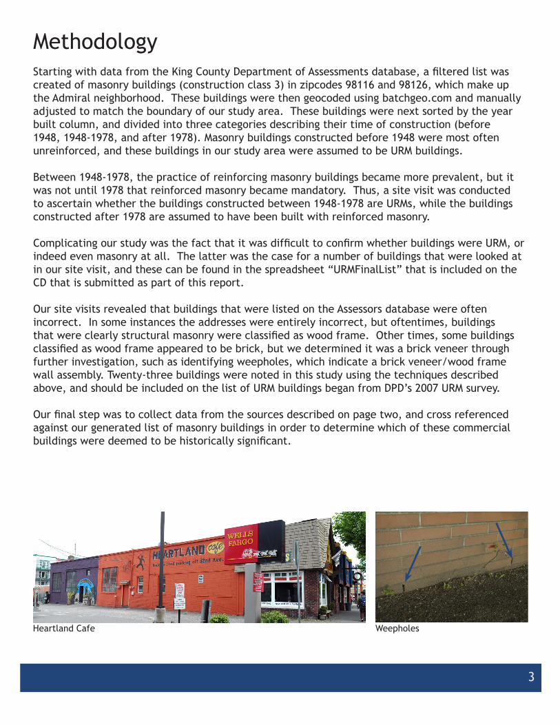
Our site visits revealed that buildings that were listed on the Assessors database were often incorrect. In some instances the addresses were entirely incorrect, but oftentimes, buildings that were clearly structural masonry were classified as wood frame. Other times, some buildings classified as wood frame appeared to be brick, but we determined it was a brick veneer through further investigation, such as identifying weepholes, which indicate a brick veneer/wood frame wall assembly. Twenty-three buildings were noted in this study using the techniques described above, and should be included on the list of URM buildings began from DPD’s 2007 URM survey.
Our final step was to collect data from the sources described on page two, and cross referenced against our generated list of masonry buildings in order to determine which of these commercial buildings were deemed to be historically significant.
Weepholes

4
Chase Bank Banquet Hall
Wiseman’s Appliance Store, Sound Orthodontics and the Ashcroft Building
James Apartments Admiral Apartments and Admiralty Antique Store

5
Present Use of Masonry Buildings
Wells Fargo

6
Construction Era of Masonry Buildings
7
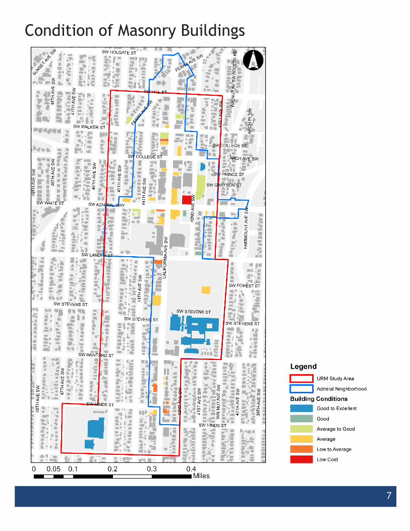
Condition of Masonry Buildings

8
Net Square Feet of Masonry Buildings
9
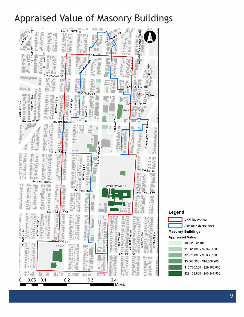
Appraised Value of Masonry Buildings

10
Seismic Retrofit Priority Assessment Flow Chart
11
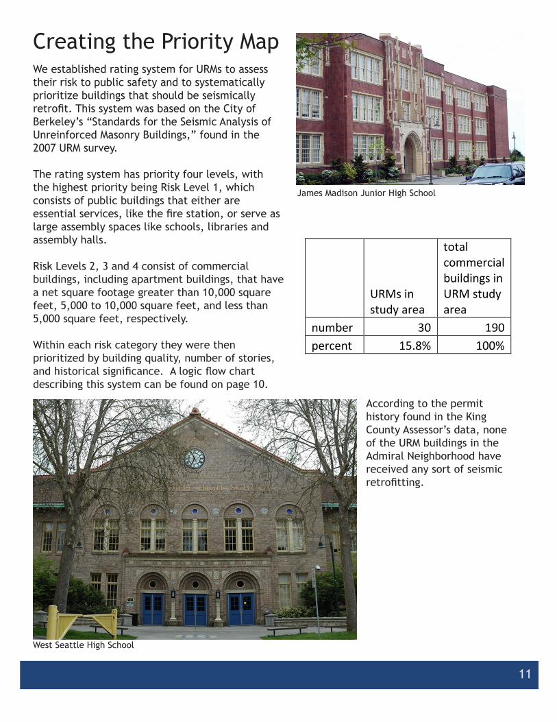
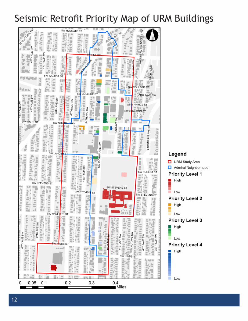
Creating the Priority MapWe established rating system for URMs to assess their risk to public safety and to systematically prioritize buildings that should be seismically retrofit. This system was based on the City of Berkeley’s “Standards for the Seismic Analysis of Unreinforced Masonry Buildings,” found in the 2007 URM survey.
The rating system has priority four levels, with the highest priority being Risk Level 1, which consists of public buildings that either are essential services, like the fire station, or serve as large assembly spaces like schools, libraries and assembly halls.
Risk Levels 2, 3 and 4 consist of commercial buildings, including apartment buildings, that have a net square footage greater than 10,000 square feet, 5,000 to 10,000 square feet, and less than 5,000 square feet, respectively.
Within each risk category they were then prioritized by building quality, number of stories, and historical significance. A logic flow chart describing this system can be found on page 10.
West Seattle High School
James Madison Junior High School
URMs in study area
total commercial buildings in URM study area
number 30 190 percent 15.8% 100%
According to the permit history found in the King County Assessor’s data, none of the URM buildings in the Admiral Neighborhood have received any sort of seismic retrofitting.
12
45TH
AVE
SW
46TH
AVE
SW
CAL
IFO
RN
IA A
VE
SW
47TH
AVE
SW SW HILL ST
39TH
AVE
SW
48TH
AVE
SW
WAL
NU
T AV
E S
W
44TH
AVE
SW
SW HANFORD ST
SW ADMIRAL WAY
SW LANDER ST
SW WALKER ST
SW HINDS ST
FAIR
MO
UN
T AV
E S
W
SW COLLEGE ST
42N
D A
VE S
W
SW HOLGATE ST
41ST
AV
E S
W
40TH
AVE
SW
SW STEVENS ST
FERRY
AVE S
W
49TH
AVE
SW
SW WAITE ST
SUNSET AVE S
W
SW FOREST ST
ARC
H P
L SW
SW PRINCE ST
WAL
NU
T AV
SW
AC
CE
SS R
D
ARCH AVE SW
SW GRAYSON ST48TH
AVE
SW
44TH
AVE
SW
47TH
AVE
SW
48TH
AVE
SW
42N
D A
VE S
W
SW STEVENS ST
FERRY AVE SW
41ST
AV
E S
W
SW HINDS ST
SW COLLEGE ST
SW STEVENS ST
SW STEVENS ST
LegendURM Study Area
Admiral Neighborhood
Priority Level 1High
Low
Priority Level 2High
Low
Priority Level 3High
Low
Priority Level 4High
Low0 0.1 0.2 0.3 0.40.05
Miles
°Seismic Retrofit Priority Map of URM Buildings

13
Fire Station No. 29
Address: 2139 Ferry Ave SWYear Built: 1970Net Square Feet: 3,929 Appraised Value: $956,500
Southeast Facade
Northwest Facade View looking Southwest towards Fire Station
View looking Northwest towards Fire Station

14
Admiralty House Antiques
Address: 2141 California Ave SWYear Built: 1926Net Square Feet: 2,500Appraised Value: $852,000
Photo looking Southwest towards Antique Store
View looking Northwest towards Antique Store
View looking Northeast towards Antique Store
View looking Southwest towards Antique Store
Recommended