Age of the Coso Formation, Inyo County, California
GEOLOGICAL SURVEY BULLETIN 1527


Age of the Coso Forn1ation, Inyo County, California
By CHARLES R. BACON, DENNIS M. GIOV ANNETT!, WENDELL A. DUFFIELD, G. BRENT DALRYMPLE, and ROBERT E. DRAKE
GEOLOGICAL SURVEY BULLETIN 1527
A re-evaluation of the age of the Coso Formation) based on potassium-argon ages of the volcanic rocks that are intercalated with) intrude) and overlie ihe Coso Formation
UNITED STATES GOVERNMENT PRINTING OFFICE, WASHINGTON : 1982

UNITED STATES DEPARTMENT OF THE INTERIOR
JAMES G. WATT, Secretary
GEOLOGICAL SURVEY
Dallas L. Peck, Director
Library of Congress Cataloging in Publication Data Bacon, CharlesR., Age of the Coso Formation, In yo County, California (Geological Survey Bulletin 1527) Bibliography: p. 18 Supt. ofDocs. No.: I 19.3:1527 I. Geology, Stratigraphic-Tertiary. 2. Geology-Califomia-Inyo County. I. Bacon, Charles R. II. Series. QE75.B9 No. 1527 [QE90.15] 557.3s 81-607973 [551.7'88'0979487) AACR2
For sale by the Branch of Distribution, U.S. Geological Survey 604 South Pickett Street, Alexandria, VA 22304

CONTENTS
Page
Abstract --- - - - - -- - - -- --- -- - -- -- - --- -- - -- -- - -- -- - - - -- - ---- - - --- - - - --- - - - -- - - 1 Introduction - -- -- ------ - -- - -- - - - -- -- --- - - - -- --- -- - -- - - - -- - - --- - - - -- - - - --- - - 1 Acknowledgments ------- ----------- -------------- ---- ------ ----- ----------- 3 Dating techniques - - - - - -- -- - -- - -- -- - -- - - -- --- -- - --- ---- - -- - - - -- - - - - -- - - - -- -- 3 Stratigraphic relations between potassium-argon-dated volcanic rocks and beds of
the Coso Formation -------------------------------------------------- 6 Miocene volcanic rocks - -- - - - - -. - ---- - -- -- - - -- --- -- ----- - --- - - - -- - -- --- - 6 Pliocene basaltic lava flow ---------------------------------------------- 12 Pliocene rhyolitic pyroclastic deposits ------------------------------------ 13 Pliocene rhyodacitic pyroclastic deposits --------------------------------- 14 Pliocene rhyodacite lava flows ------------------------------------- ----- - 16
Conclusions ---------------------------------------------------- ---- -------- 16 References cited - - -- -- -- - -- -- --- - - --- -- - - - -- - --- -- - - - - - - -- - -- - - - - - - -- - - -- - - - 17
ILLUSTRATIONS
Page
FIGURE 1. Distribution of Coso Formation - -- -- -- - - - --- - ------ - - --- -- -- - - - -- - - - 2 2. View southwest from near locality 68------------------------------- 7 3. Geologic map of northernmost exposures of Coso Formation - -- - - - -- -- 8 4. Correlation sections of southeastern Owens Valley and Coso Range rocks 9 5. Contact of invasive basalt flow with Coso formation ----------------- 10 6. Intrusive contact between rhyolite plug-dome and Coso rocks -------- 12 7. Intrusive contact between rhyodacite and Coso Formation rocks -- ---- 13
TABLES
Page
TABLE 1. Analytical data for potassium-argon measurements -------------------- 4 2. Fission-track data ------------------------------------------------- 6 3. Composition of feldspars------------------------------------------- 14
III


AGE OF THE COSO FORMATION,
INYO COUNTY, CALIFORNIA
By CHARLES R. BACON, DENNIS M. GIOV ANETII,
WENDELL A. DUFFIELD, G. BRENT DALRYMPLE, and
ROBERT E. DRAKE
ABSTRACT
The late Tertiary Coso Formation consisting of sedimentary and volcaniclastic rocks occurs in the Coso Range and at the south end of Owens Valley, Calif. Potassium-argon dating of the volcanic rocks that overlie, are intercalated with, and intrude the Coso indicates that the Coso Formation contains strata at least as old as 6.0 m.y. (million years) and no younger than 2.5 m.y. Within the Coso Formation, Blancan fossils from a locality on the northern slope of the Coso Range are probably 3.0 m.y. old and a Hemphillian fossil was recovered northeast of there from beds between 3.6 and 5.3 m.y. old. A rhyodacite and four rhyolite plug domes that intrude sedimentary rocks of the Coso on the northern flank of the Coso Range range in age from 5.7 to 6.0 m.y.
The late Miocene fluvial and lacustrine sedimentary rocks of the Coso Formation suggest that a shallow basin had formed in southern Owens Valley by about 6 m.y. ago. Airfall tuff and coarse clastic sedimentary rocks of the Coso Formation within the Coso Range suggest that block faulting had begun by about 3 m.y. ago.
INTRODUCTION
Tertiary sedimentary rocks that predate Quaternary alluvial deposits at the south end of Owens Valley, the westernmost basin of the Basin and Range province, and in the Coso Range have been mapped by a number of workers as the Coso Formation (fig. 1). This formation is of interest because it records sedimentation in response to deformation at the western margin of the Basin and Range province, and it contains vertebrate fossils of Hemphillian and Blancan mammalian ages and uranium minerals of potential economic importance.
Late Cenozoic rocks in the area that are now included in the Coso Formation were described by early workers (for example, Knopf, 1918). Schultz (1937) defined the Coso Formation to include all Cenozoic sedimentary deposits in the area that lie beneath late Cenozoic lava flows and described vertebrate fossils from two localities within the Coso at the north end of the Coso Range. In light of more recent work,
1

2
15'
c:: 0
·.;:::; co
E 0 u.. 0 U)
0 u
AGE, COSO FORMATION, INYO COUNTY, CALIF.
Owens Lake (dry)
m
)>
z
m
<
)>
c 0 s 0
R A N G E
Upper Cactus
Flat
•43
,., EXPLANATION
~ Pyroclastic deposits
~Fanglomerate
I2IT] Arkosic and lacustrine deposits
--Contact
•52 K-Ar sample locality
.A Locality that yielded Coso Hot Agriotherium remains Springs A
•F Approximate location <.....$48 (Stinson, 1964) of !' fauna described by Schultz (1937)
36° OO'L_ __________ L_ ____________________________ L_ __ ~----------~
10 15 20 KILOMETERS
FIGURE !-Distribution of the Coso Formation generalized and modified from Hall and MacKevett (1962), Stinson (1977a, b), Duffield and Bacon (1981), and Giovannetti (1979a). Numbers refer to sample localities of table 1 and Duffield, Bacon, and Roquemore (1979).

DATING TECHNIQUES 3
Schultz's definition (1937, p.79) of the Coso should be clarified because the lava flows in the Coso Range have a wide age range. We believe that the lava flows referred to by Schultz are the rhyodacite flows on the Haiwee Ridge (fig. 1) described in the section on Pliocene rhyodacite lava flows.
Parts of the Coso Formation have been described by Hopper (1947), Power (1959, 1961), Bacon and Duffield (1978), Duffield, Bacon, and Roquemore (1979), Duffield, Bacon, and Dalrymple (1980), and Giovannetti (1979a, b). Deposits mapped as the Coso (fig. 1) Occur in the Haiwee Reservoir (Stinson, 1977a), Keeler (Stinson, 1977b), and Darwin (Hall and MacKevett, 1962) 15-minute quadrangles and have been mapped in the Coso volcanic field (Duffield and Bacon, 1981).
Potassium-argon dating of volcanic rocks intercalated with, and overlying, the Coso Formation has been used by Evernden, Savage, Curtis, and James (1964), Bacon, Giovannetti, Duffield, and Dalrymple (1979), and Duffield, Bacon, and Dalrymple (1980) to constrain the age of the Coso. In this report, we review these potassium-argon ages and present additional data that provide more accurate limits on the age of the Coso Formation.
ACKNOWLEDGMENTS
We thank C. A. Repenning for advice on paleontologic aspects of this study. G. R. Roquemore contributed valuable observations of field relations of pyroclastic rocks near Sugar Loaf. J. Metz painstakingly prepared and analyzed glass fractions of tuffs. C. E. Meyer and M. J. Woodward kindly determined fission-track ages of zircons. Part of this report is based on the second author's M. S. thesis, which was completed under the guidance of Professor R. L. Hay. Potassi urn-argon age determinations at the University of California, Berkeley, were made possible through National Science Foundation grant EAR76-21833.
DATING TECHNIQUES
Potassium and argon analyses were performed on crushed whole-rock samples of obsidian and basalt and on separates of sanidine, plagioclase, and biotite. The analytical data are presented in table 1 and include some data published previously (Duffield and others, 1980) for the sake of completeness. Analyses of samples from localities 43-66 were performed at the U.S Geological Survey, Menlo Park, Calif., as described by Duffield, Bacon, and Dalrymple (1980); those for localities 67-72 were made at the University of California at Berkley by techniques described by Dalrymple and Lanphere (1969).
Fission-track ages of zircons (table 2) were determined by techniques described by Naeser (1976).

~
TABLE !.-Analytical data for potassium-argon measurements on volcanic rocks [Samples from localities 43 to 66 analyzed at U.S. Geological Survey, Menlo Park, California; 67-72 analyzed at Department of Geology and Geophysics, University of California, Berkeley, California;.
43-63 from Duffield, Bacon, and Dalrymple (1980). Analytical constants: AE+AE' = 0.581X 10- 10 yr- 1, >.13
=4.692X10- 10 yr- 1, 4°K/K = 1.167X 10-• moVmol. Errors are estimated standard devia-tions (Cox and Dalrymple, 1967))
> 0
Per- 40Arrad Per- Calcu- Weighted J:rJ Loc- Sample Lat Long Stratigraphic Material centage Weight (X1012 centage latedage mean age ("':) ality No. relations K20 (gm) mol/gm) .. Arrad (million years) (million years) 0
r:n 0
43 9--8-11 36°06'04" 117°50'02" Near top of Coso Formation, Biotite --------- 6.48, 6.47 1.151 22.975 2.4 2.46±0.98 '"%j Upper Cactus Flat; 0 air-fall pumice. Plagioclase------ 0.460, 0.457 5.863 2.004 16.0 3.04±0.20 ~ 2.99±0.20
48 13-113-6 36°02'10" 117°44'22" Near top of Coso Formation, Biotite --------- 7.01, 6.98 1.96 33.45 4.1 3.31±0.42 > t-3 East of Coso Hot l-ot
Springs; air-fall pumice. Plagioclase------ 0.524, 0.513 6.108 2.203 24.4 2.95±0.13 0 ,;Z
44 9-85-2 36°11'56" 117°55'14" Within Coso Formation, Biotite --------- 7.62, 7.67 1.977 41.34 5.9 3.75±0.32} l-ot
between Cactus Flat 3.14±0.15 z and Haiwee Reservoir; Sanidine---- ---- 12.31, 12.32 3.835 54.88 66.2 3.09±0.09 t<
0 pumice in ("':) pyroclastic flow. 0
52 75G317 36°08'02" 117°52'00" Overlies Coso Formation, Biotite --------- 8.63, 8.63 27.8} c::::
{4.711 30.90 251±0~1 z McCloud Flat; 5.208 31.69 33.6 t-3 rhyodacite lava flow. 2.52±0.05 ~t<
61 13-43-13 36°06'00" 117°53'32" Overlies Coso Formation, - -do - - -- - - - - - - - 8.58, 8.55 3.357 31.40 24.5 2.54±0.05 ("':)
> Haiwee Ridge; t""' rhyodacite lava flow. ~
63 8-191-1 36°14'10" 117°45'20" Within Coso Formation, Basalt _______ ---{0.883, 0.884} {13.406 4.087 11.7} 3.56±0.10 Upper Centennial Flat; 0.880, 0.886 15.521 4.736 45.9
lava flow.
64 13-51-1 36°19'12" 117°52'00" Intrudes Coso Formation, Biotite - -------- 8.83, 8.84 1.628 72.90 47.0 5.72±0.17 NW slope of Coso Range; rhyolite plug.

65 13-52-2 36°20'16" 117°50'24" Intrudes Coso Formation, Obsidian ------- {4
·35• 4
·26
} f.184 36.88 43.2} 5.99±0.08 N. end of Coso Range; 4.32, 4.27 3.437 37.44 54.9
rhyolite plug.
66 13-52-3 36°20'32" 117°50'22" Intrudes Coso Formation, _-do -----------{4.32,4.28} {3.211 36.58 48.3} 5.98±0.06 N. end of Coso Range; 4.32, 4.28 3.323 37.37 42.1
rhyolite plug.
67 78--G-137 36°22'20" 117°49'44" Invades Coso Formation, Basalt ---- --- --- 1.238 5.038 10.49 38.30 5.88±0.18 between Coso River and lnyo Mountains; lava flow.
68 78-G-133 36°22'36" 117°49'20" Overlain by Coso Formation, - -do ---- ----- -- 1.450 4.965 10.98 22.8 5.25±0.23 between Coso River and Inyo Mountains; tj
> lava flow. :j 69 78--G-70 36°22'54" 117°48'54" Interbedded with Coso Sanidine--------10.18 3.192 86.55 83.1 5.90±0.12 z
Formation, between Coso 0 River and Inyo t-3
t_:r::j Mountains; rhyolite 0 dome breccia. ::X:: z
70 78--G-135L 36°23'12" 117°48'18" Overlain by Coso Formation, Basalt ----- ----- 1.907 5.004 15.40 69.8 5.60±0.17 ...... .0
between Coso River c::: and lnyo Mountains; t_:r::j
lava flow. en
71 78-G-131 36°23'24" 117°50'42" Overlies Coso Formation, - -do -- -- ---- --- 1.299 5.006 10.35 25.1 5.53±0.22 between Coso River and Inyo Mountains; lava flow.
72 78-G-130 36°23'54" 117°50'00" Overlies Coso Formation, - -do ---- ------ - 1.282 5.070 11.17 22.9 6.04±0.26 between Coso River and Inyo Mounains; lava flow.
01
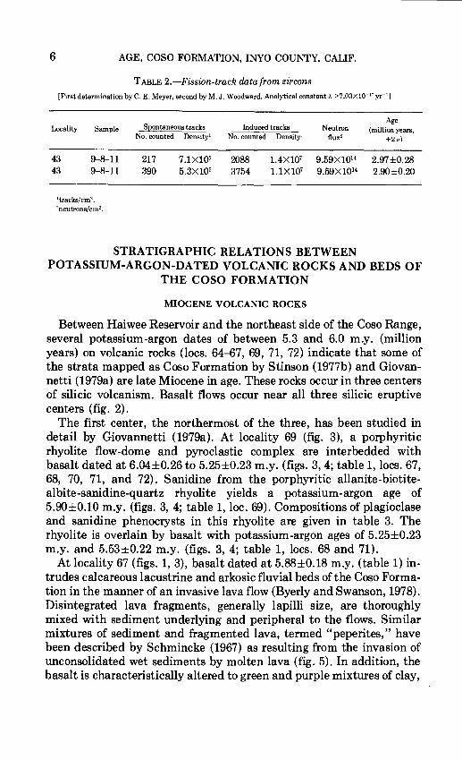
6 AGE, COSO FORMATION, INYO COUNTY, CAUF.
TABLE 2.-Fission-track data from zircons [First determination by C. E. Meyer, second by M. J. Woodward. Analytical constant X :?.7.03xl0- 17 yr- 1
]
Locality Sample
43 9-8--11 43 9-8-11
1tracks/cm2 •
2neutrons/cm2•
Spontaneous tracks No. counted Density'
217 7.1X10⁵
390 5.3X10⁵
Induced tracks Neutron Age
(million years, No. counted Density' flux 2
±2u)
2088 1.4X10⁷ 9.59X10¹⁴ 2.97±0.28 3754 1.1X10⁷ 9.59X10¹⁴ 2.90±0.20
STRATIGRAPHIC RELATIONS BETWEEN POTASSIUM-ARGON-DATED VOLCANIC ROCKS AND BEDS OF
THE COSO FORMATION
MIOCENE VOLCANIC ROCKS
Between Haiwee Reservoir and the northeast side of the Coso Range, several potassium-argon dates of between 5.3 and 6.0 m.y. (million years) on volcanic rocks (locs. 64-67, 69, 71, 72) indicate that some of the strata mapped as Coso Formation by Stinson (1977b) and Giovannetti (1979a) are late Miocene in age. These rocks occur in three centers of silicic volcanism. Basalt flows occur near all three silicic eruptive centers (fig. 2).
The first center, the northermost of the three, has been studied in detail by Giovannetti (1979a). At locality 69 (fig. 3), a porphyritic rhyolite flow-dome and pyroclastic complex are interbedded with basalt dated at 6.04±0.26 to 5.25±0.23 m.y. (figs. 3, 4; table 1, locs. 67, 68, 70, 71, and 72). Sanidine from the porphyritic allanite-biotitealbite-sanidine-quartz rhyolite yields a potassium-argon age of 5.90±0.10 m.y. (figs. 3, 4; table 1, loc. 69). Compositions of plagioclase and sanidine phenocrysts in this rhyolite are given in table 3. The rhyolite is overlain by basalt with potassium-argon ages of 5.25±0.23 m.y. and 5.53±0.22 m.y. (figs. 3, 4; table 1, locs. 68 and 71).
At locality 67 (figs. 1, 3), basalt dated at 5.88±0.18 m.y. (table 1) intrudes calcareous lacustrine and arkosic fluvial beds of the Coso Formation in the manner of an invasive lava flow (Byerly and Swanson, 1978). Disintegrated lava fragments, generally lapilli size, are thoroughly mixed with sediment underlying and peripheral to the flows. Similar mixtures of sediment and fragmented lava, termed "peperites," have been described by Schmincke (1967) as resulting from the invasion of unconsolidated wet sediments by molten lava (fig. 5). In addition, the basalt is characteristically altered to green and purple mixtures of clay,

STRATIGRAPHIC RELATIONS
Sugar loaf I
7
FIGURE 2.-View looking southwest from near locality 68. Basalt lava flows in foreground. Coso Formation underlying 5-m.y.-old basalt lava flow in middle distance; northern end of Coso Range in the far distance; Sugar Loaf, the small rounded feature in the middle distance, is a porphyritic rhyodacite plug-dome; Sierra Nevada forms right skyline.
carbonate, and hydrated iron oxide minerals. Similar relations are evident between basalt and sedimentary rocks between localities 66 and 67 (Bacon and Duffield, 1978).
Near the northernmost rhyolite complex (loc. 69), arkosic sedimentary deposits are intercalated with basalt flows, some of which may be invasive. A thick (30m), altered dacite flow appears to be the youngest volcanic rock in the area. Relatively extensive alteration of most of these volcanic rocks suggests water saturation of the sediments into or onto which they flowed. The presence of large euhedral crystals of gypsum and scalenohedrons of calcite in vugs and fractures suggests post eruption exposure of the volcanic rocks to high-salinity, alkaline water, either from groundwater or shallow lakes. Bedded arkosic fluvial sedimentary rocks overlie the entire section of volcanic rocks in this area (Giovannetti, 1979a, b). It was from these sedimentary rocks that the Agriotherium remains were recovered. The 4.8- to 6.2-m.y. age implied for Agriotherium is consistent with the maximum age for these rocks as indicated by the 5.3- to 5.9·-m.y. potassium-argon ages of the volcanic rocks stratigraphically beneath them (locs. 68-70) and the

8
36° 25'
36° 20'
I
AGE, COSO FORMATION, INYO COUNTY, CALIF.
Owens /
,/
/"
Lake /,/ (dry) /
,,./'-'.,"
)
D Alluvium
I I
CE1 Coso Formation
Rhyolite
Dacite
EXPLANATION ci:: }w>- rm t-0:: Basalt <(<( v :JZ
li EJ Basement rock
--Contact
.71 K-Ar sample locality
.A Locality that yielded
' I- Agriotherium remains
Lower Centennial
Flat
FIGURE 3.-Geologic map of area showing northernmost exposures of Coso Formation, modified from Stinson (1977a, b) and Giovannetti (1979a); faults omitted.

East of Haiwee
Reservoir
Haiwee Ridge Southeast of Coso
Hot Springs c:J=c><::> 25
~:::'4-~;;t ,;>' -------------- · -o.u 1.,." •. ·.c • , oo 1 c c::l C:::J Cl-
~_: _-_. <:::;, <:?
Northeast of Coso
Hot Springs
g {'~ ~·.:; ~ 0 C1l
u § 0 I,A .aQ..q
u.. ~~~~
~~~~
~
EXPLANATION
Fanglomerate
Air-fall pyroclastic deposits
Silicic flows, domes, and plugs
Basalt flows
~ ~ ~
Lacustrine and fluvial deposits
Pyroclastic flows
[ill Dacite flows
~ ~ Granitic rocks
5.3 K-Ar age, in millions of years
~ 3.0 ..
~,·,·,,:,·;·n5.3
5.6
_____ ...-. {
5.7 3 plugs 6.0
6.0
Upper and Lower
--=:--=----= ~::~-=-=
FIGURE 4.-Schematic stratigraphic sections of the southeastern Owens Valley and Coso Range showing correlation and age of volcanic and sedimentary rocks. Unit A is rhyolite pumice of locality 44 and compositionally similar, apparently correlative deposits; B is rhyodacite air-fall pumice of locations 43 and 48. Stratigraphic relation between A and B northeast of Coso Hot Springs inferred.
w o-3
~ ~ ~ > "d ::r:: (3 ::0 t,:tj t'"'
~ 0 z w
co

10 AGE, COSO FORMATION, INYO COUNTY, CAUF.
FIGURE 5.-Contact of an invasive basalt flow with sedimentary rocks of the Coso Formation near locality 67. Fragments of highly altered columnar basalt are locally mixed with clay-rich sediment. Pencil gives scale.

STRATIGRAPHIC RELATIONS 11
m1n1mum age defined by the 3.6-m.y .. -old basalt (loc. 63) overlying them.
The second center comprises a group of three aphyric, apparently coeval rhyolite plug-domes (figs. 3, 4; locs. 65 and 66) that intrude tuffaceous lacustrine and fluvial sediments mapped as Coso Formation by Stinson (1977b). The three plugs consist predominantly of felsite and minor perlitic glass; the southern and middle ones contain small amoants of obsidian (marekanite) that are chemically identical (C. R. Bacon and R. L. Smith, unpub. data, 1977) and yield potassium-argon ages of 5.99±0.08 and 5.98±0.06 m.y. (table 1, locs. 65 and 66, respectively). Thin beds of arkosic fluvial and tuffaceous lacustrine sediments are nearly flat lying within less than 100m of the plug-domes but have been forced into nearly vertical attitudes adjacent to the plug-domes by intrusion of the rhyolite (fig. 6). Glassy and devitrified zones appear to parallel contacts with sedimentary rocks, although not so clearly as at Sugar Loaf (fig. 7). Moderately dipping air-fall and base-surge rhyolitic pyroclastic deposits with abundant, well-developed accretionary lapilli are exposed in a small drainage adjacent to the northernmost plugdome on its northwest side. These plug-domes are the Olancha domes of Friedman and Smith (1958) and Smith and Shaw (1975).
The third center, Sugar Loaf, is a porphyritic rhyodacite plug-dome. This dome has yielded a potassium-argon biotite age of 5. 72±0.17 m.y. (figs. 3, 4; table 1, loc. 64). Several lines of evidence here suggest that the rhyodacite intrudes the tuffaceous fluvial and lacustrine beds of the Coso Formation and the intercalated basalt: (1) the sedimentary deposits dip steeply away from the contact with the rhyodacite, whereas less than 100 m from the contad, they dip gently; (2) foliation in the rhyodacite, as defined by platy jointing and by preferred orientation of phenocrysts, is steep to vertical everywhere near the contact and is nearly parallel to the contact (fig. 7); (3) abundant columnar joints, 10 em in diameter, are oriented perpendicular to the contact (fig. 7); ( 4) crystallization of the rhyodacite is concentrically zoned, with a discontinuous band of dark vitrophyre about 1m thick at the margin (fig. 7), followed by several meters of gray perlite that grade into a pink, largely devitrified core; and (5) the sediments, particularly those rich in clay, are altered and appear to be baked near contacts with the rhyodacite. Stinson (1977b) also noted the intrusive nature of the contact between this rhyodacite and the Coso. Approximately 350 m due west of the southern margin of the Sugar Loaf plug-dome, a 3-m-thick bed of pumiceous rhyodacite blocks is interbedded with clayey arkosic sandstone. The blocks form an avalanche or pyroclastic-flow deposit from Sugar Loaf, indicating that the rhyodacite reached the surface and that sedimentation of the Coso was in progress before and at the time of emplacement of the plug-dome.

12 AGE, COSO FORMATION, INYO COUNTY, CALIF.
FIGURE 6.-Intrusive north contact between middle rhyolite plug-dome (left; middle Olancha dome of Smith and Shaw, 1975) and sedimentary rocks of the Coso Formation. Prominent, steeply dipping outcrops are flow-banded vitrophyre just within rhyolite from contact. Bedding in Coso sedimentary rocks is virtually parallel to contact and flow banding. Note man (in circle) for scale.
PLIOCENE BASALTIC LA VA FLOW
At the north end of Upper Centennial Flat in the Coso Range, basalt dated at 3.56±0.10 m.y. (Duffield and others, 1980; fig. 1; table 1, loc. 63; fig. 4) is overlain by alluvial fan deposits of the Coso Formation. These deposits contain a bed of hornblende-biotite-rhyodacite pumice lapilli. The pumice in this bed is probably correlative with pumice (table 1, locs. 43 and 48) dated at about 3.0 m.y. Thus, these alluvial fan deposits are probably in the upper part of the Coso Formation. Five kilometers to the north, at Lower Centennial Flat, the same basalt flow lies on about 100m of calcareous lacustrine and arkosic fluvial deposits (fig. 3) that were assigned to the Coso Formation by Hall and MacKevett (1962) and by Stinson (1977b). The arkosic deposits may be correlative with similar deposits 10 km to the north-northwest (figs. 1, 3, loc. A) where a mandibular ramus identified as Agriotherium sp. cf. A. sivalensis (C. A. Repenning, written commun., 1979) was found by D. W. Andersen. According to Repenning, Agriotherium lived in North America in late Hemphillian time, most probably between 4.8 and 6.2 m.y. ago.

STRATIGRAPHIC RELATIONS 13
PLIOCENE RHYOLITIC PYROCLASTIC DEPOSITS
Rhyolitic air-fall and ash-flow deposits of the Coso Formation occur at several localities. All the occurrences described in the following paragraphs apparently represent a single eruption, or a series of eruptions closely spaced in time, from vents immediately east of Haiwee Reservoir.
A weighted-mean potassium-argon age of 3.14±0.15 m.y. on sanidine and biotite from large pumice lumps in a rhyolite ash-flow tuff of the Coso Formation (loc. 44; Duffield and others, 1980) provides age control for the upper part of the Coso. This ash-flow tuff, mapped as rhyolite tuff breccia by Stinson (1977a), is interbedded with lacustrine deposits of the Coso east of the northern part of Haiwee Reservoir (fig. 4). Pumice in the ash-flow tuff contains phenocrysts of quartz, oligoclase, sanidine, and biotite. Rhyolite pumice identical in appearance to that in the ash-flow tuff east of the Haiwee Reservoir occurs northeast of Coso Hot Springs in a bed 1 m thick within alluvial deposits, which are overlain by a dacite lava flow (fig. 4).
Similar pumice and ash form base-surge and near-vent explosion deposits at the base of the pyroclastic section mapped as Coso Forma-
FIGURE 7.-Intrusive contact between rhyodacite of Sugar Loaf and sedimentary rocks of the Coso Formation. Flow banding and dark vitrophyric zone in rhyodacite are parallel to contact; columnar joints are perpendicular. Sugar Loaf is to right (west) in photo. Pick at contact gives scale.

14 AGE, COSO FORMATION, INYO COUNTY, CALIF.
tion at the south end of Haiwee Ridge (fig. 4; Duffield and Bacon, 1981; Duffield and others, 1980).
An approximately 30-cm-thick bed of reworked rhyolite pumice lapilli is present within sedimentary rocks of the Coso about 1.5 km northwest of the vertebrate fossil locality (fig. 1, loc. F) described by Stinson (1964). This material apparently came from the same volcanic source as the rhyolite ash flow, on the basis of phenocryst assemblage and rubidium, strontium, yttrium, and zirconium content (X-ray flourescence analyses) of glass seperated from pumice. Microprobe analyses show the oligoclase and sanidine to be similar to, but slightly more sodic than, the same phases in pumice from the ash-flow tuff (table 3). This observation is consistent with the idea that the bed of pumice lapilli represents the reworked air-fall component of the same eruption that resulted in emplacement of the ash-flow tuff (Hildreth, 1979). By similar reasoning, it is unlikely that the pumice lapilli are related to emplacement of the late Miocene rhyolitic plug-domes because feldspars from the only porphyritic rhyolite (table 3, loc. 69) are more sodic than would be expected if the reworked pumice lapilli were to represent an early phase of emplacement.
TABLE 3.-Compositions of feldspars in silicic rocks
[Compositions calculated from average analyses of phenocrysts determined with ARL-EMX electron microprobe. See Bacon and Duffield (1981) for operating conditions and data reduction techniques)
Weighted mean Average composition of feldspar (mole percent)
Locality Sample K-Arage Type of
No. of deposit Sanidine Plagioclase deposit (million years) An Ab Or An Ab Or
F 9-90-2 Not present --- 42.4 55.2 2.4 Pumice in water-laid tuff. 43 9-8-11 3.0 ---do. -------- 41.2 56.5 2.3 Pumice in air-fall tuff. 48 13-113-6 3.0 ---do. -------- 33.6 63.1 3.3 ---Do.-----------
9-90-1 0.5 30.5 69.0 11.9 82.8 5.3 Pumice in reworked tuff. 44 9-85-2 3.1 .6 26.5 72.9 15.5 79.4 5.1 Pumice in ash-flow tuff. 69 77CDG-70 5.9 .6 34.4 65.0 9.0 84.4 6.6 Pumiceous rhyolite from
dome.
PLIOCENE RHYODACITIC PYROCLASTIC DEPOSITS
A thick sequence of porphyritic rhyodacite air-fall, ash-flow, and base-surge deposits overlies the rhyolite pumice deposits at the south end of Haiwee Ridge (Fig. 4; Duffield and others, 1979, 1980). These rhyodacite deposits were mapped as andesite tuff and breccia by Stinson (1977a). Biotite and plagioclase from pumice in correlative rhyodacite air-fall deposits from two widely separated localities in the

STRATIGRAPHIC RELATIONS 15
Coso Range yield a weighted-mean age of 2.99±0.20 m.y. (Duffield and others, 1980; locs. 43 and 48). Fission-track ages of zircons from the pumice (table 2) are in good agreement with the potassium-argon age. This rhyodacite pumice is easily recognized by its biotite-hornblendeandesine phenocryst assemblage and thus provides a means for the correlation of sedimentary rocks throughout much of the Coso Range (fig. 1, this report; Duffield and Bacon, 1981; Duffield and others, 1980). Airfall deposits of this rhyodacite pumice occur interbedded with coarse alluvial sedimentary deposits mapped as Coso in a series of grabens south of lat. 36°15' N (Duffield and others, 1979).
Pumice studied by Evemden, Savage, Curtis, and James (1964; sample KA 451) from a water-laid tuff reported to be about 30 m stratigraphically above the Blanchan vertebrate fossil locality (fig. 1, loc. F) described by Schultz (1937; loc. 131) and Stinson (1964) is apparently reworked 3.0-m.y.-old rhyodacite air-fall tephra. We collected several rounded pumice lumps 1-5 em in diameter from a bed of waterlaid tuff believed to be that described by Evernden, Savage, Curtis, and James (1964). This pumice contains the same phenocryst assemblage as does that from Haiwee Ridge; glass separated from one large lump has contents of rubidium, strontium, yttrium, and zirconium (determined by X-ray flourescence) that are closely similar to glass from pumice of the 3.0-m.y .-old rhyodacite air-fall tuff of Haiwee Ridge. Plagioclase phenocrysts in all Coso rhyodacitic rocks are complexly zoned; consequently, microprobe analyses of crystal fragments separated from pumice lumps are variable. Despite this fact, the average compositions determined by analyzing many grains are very similar for the pumice lumps from the water-laid tuff and for dated air-fall pumice (table 3), and this similarity provides further evidence for correlation. The large, rounded pumice lumps were probably derived from air-fall tuff shortly after its deposition. The possibility that the pumice was reworked much more recently is considered remote but cannot be ignored. Thus, the rocks containing the vertebrate fossils at this locality are probably about 3.0 m.y. old. Evemden, Savage, Curtis, and James (1964) determined the potassium-argon age of biotite from pumice lumps, apparently from the same outcrop of water-laid tuff. The biotite concentrate analyzed by them (sample KA 451) contained only 4 percent radiogenic 40Ar and 3.87 percent K20. When recalculated using current decay constants (table 2), the original analytical data yield an age of 2.31 m.y. with a large unevaluated analytical error; we believe that this defines only an imprecise minimum age for the pumice because of the appparently altered or very impure nature of the biotite concentrate.
Wilson (1932) described a small rodent, Cosomys primus, from the same locality studied by Schultz (1937, loc. 131). He tentatively assigned a Pliocene (Blanchan) age to fossiliferous strata, on the basis of

16 AGE, COSO FORMATION, INYO COUNTY, CALIF.
horse material. Neville, Opdyke, Lindsay, and Johnson (1979), investigating the magnetic stratigraphy, radiometric age relationships, and fossil mammals of the Glenns Ferry Formation in Idaho, determined an age of 3.75 m.y. for the lowest stratigraphic occurence of Cosomys. According to C. A. Repenning (written commun., 1979) Cosomys primus from the Coso Formation is about 3.4 m.y. old. The pumice-bearing water-laid tuff appears to be no older than 3.0 m.y. Consequently, if the relation of the tuff to the fossiliferous strata is correct, a gap in the record may be present or an unusually low sedimentation rate may have pertained to the intervening period.
PLIOCENE RHYODACITE LAVA FLOWS
Several thick flows of porphyritic rhyodacite overlie both the rhyolite and rhyodacite pumice deposits of the Coso Formation in the vicinity of Haiwee Ridge (Duffield and Bacon, 1981; Duffield and others, 1980). These flows were described as andesite by Stinson (1977a) and Chesterman (1956). All the flows are similar in appearance and composition; the weighted mean of two biotite age determinations is 2.52±0.05 m.y. (table 1, locs. 1 and 2; Duffield and others, 1980). This age is probably consistent with an age of 2.01 m.y. calculated from the original data of Evernden, Savage, Curtis, and James (1964, sample KA 1026) for low-potassium biotite from the northernmost flow. Duffield, Bacon, and Dalrymple (1980, loc. 51) were unable to obtain a meaningful age for either biotite or hornblende from the same locality studied by Evernden and coworkers (sample KA 1026). Some of the rhyodacite flows fill canyons in the under lying pyroclastic rocks of the Coso Formation (fig. 4; Duffield and others, 1980) and provide a minimum age of approximately 2.5 m.y. for the Coso Formation.
CONCLUSIONS
The potassium-argon ages of volcanic rocks that overlie, are interbedded with, and intrude the Coso Formation indicate that the formation includes strata that range in age from somewhat greater than 2.5 m.y. to at least 6.0 m.y. old and that the Coso Formation is Miocene and Pliocene in age. The oldest exposed part of the Coso Formation crops out from the north end of the Coso Range northeast to the lnyo Mountains. Sedimentary rocks of the Coso Formation northeast of the Coso Range contain a vertebrate fossil (Agriotherium) that is not younger than 4.8 m.y. old. The 3.0-m.y. age implied for the Blanchan fossilbearing strata of the Coso in the Coso Range (fig. 1, loc F) described by Schultz (1937, locs. 131 and 284) is consistent with radiometric age
REFERENCES CITED 17
determinations on rocks associated with Blanchan faunas from other areas (C. A. Repenning, oral commun., 1978; Repenning, 1980); the 2.3-m.y. age calculated from the data of Evernden, Savage, Curtis, and James (1964) is probably a minimum age.
The age of the Owens Valley, the westernmost basin of the Basin and Range province, is of considerable significance to the history of Basin and Range extension. Fluvial and lacustrine deposits exposed northeast of the Coso Range indicate that a basin, possibly the tectonic precursor to the Owens Valley, began collecting sediment at least 6 m.y. ago. Crustal instability in the region is documented by the presence of arkosic sedimentary rocks and by the contemporaneous eruption of mafic and silicic volcanic rocks. Sedimentary rocks slightly older than 2.5 m.y. occur in the northwestern Coso Range and coarse 3-m.y.-old clastic sedimentary deposits are cut by graben-forming faults in the interior of the range. Volcanism began within the Coso Range approximately 4 m.y. ago (Duffield and other~, 1980). The ages of volcanic and sedimentary rocks in southern Owens Valley show a shift from early volcanism and sedimentation (5-6 m.y .) on the north flank and northeast of the Coso Range to later volcanism, block faulting, and sedimentation (2.5-4 m.y .) within the range.
REFERENCES CITED
Bacon, C. R., and Duffield, W. A., 1978, Soft-sediment deformation near the margin of a basalt sill in the Pliocene Coso Formation, Inyo County, California: Geological Society of America Abstracts with Programs, v. 10, no. 3, p. 103.
__ 1981, Late Cenozoic rhyolites from the Kern Plateau, southern Sierra Nevada, California: American Journal of Science, v. 281, p. 1-34.
Bacon, C. R., Giovannetti, D. M., Duffield, W. A., and Dalrymple, G. B., 1979, New constraints on the age of the Coso Formation, Inyo County, California: Geological Society of America Abstracts with Programs, v. 11, no. 3, p. 67.
Byerly, Gary, and Swanson, D. A., 1978, Invasive Columbia River Basalt flows along the nothwestern margin of the Columbia Plateau, north-central Washington: Geological Society of America Abstracts with Programs, v. 10, no. 3, p. 98.
Chesterman, C. W., 1956, Pumice, pumicite, and volcanic cinders in California: California Division of Mines Bulletin 174, p. 1-97.
Cox, Allan, and Dalrymple, G. B., 1967, Statistical analysis of geomagnetic reversal data and the precision of potassium-argon dating: Journal of Geophysical Research, v. 72, p. 2603-2614.
Dalrymple, G. B., and Lanphere, M. A., 1969, Potassium-argon dating: San Francisco, W. H. Freeman and Co., 258 p.
Duffield, W. A., and Bacon, C. R., 1981, Geologic map of the Coso volcanic field and adjacent areas, Inyo County, California: U.S. Geological Survey Miscellaneous Investigations Map I-1200.
Duffield, W. A., Bacon, C. R., and Dalrymple, G. B., 1980, Late Cenozoic volcanism, geochronology, and structure of the Coso Range, In yo County, California: Journal of Geophysical Research, v. 85, p. 2381-2404.
18 AGE, COSO FORMATION, INYO COUNTY, CALIF.
Duffield, W. A., Bacon, C. R., and Roquemore, G. R., 1979, Origin ofreverse-graded bedding in air-fall pumice, Coso Range, California: Journal of Volcanology and Geothermal Research, v. 5, p. 35-48.
Evernden, J. F., Savage, D. E., Curtis, G. H., and James, G. T., 1964, Potassium-argon dates and the Cenozoic mammalian chronology ofN~rth America: American Journal of Science, v. 262, p. 145-198.
Friedman, Irving, and Smith, R. L., 1958, The deuterium content of water in some volcanic glasses: Geochimica et Cosmochimica Acta, v. 15, p. 218-228.
Giovannetti, D. M., 1979a, Mio-Pliocene volcanic rocks and associated sediments of southeastern Owens Lake, lnyo County, California: Berkeley, California, University of California, M.S. thesis, 76 p.
___ 1979b, Volcanism and sedimentation associated with the formation of southern Owens Valley, California: Geological Society of America Abstracts with Programs, v. 11, no. 3, p. 79.
Hall, W. E., and MacKevett, E. M., Jr., 1962, Geology and ore deposits of the Darwin quadrangle, lnyo County, California: U.S. Geological Survey Professional Paper 368, 87 p.
Hildreth, Wes, 1979, The Bishop Tuff: Evidence for the origin of compositional zonation in silicic magma chambers, in C. E. Chapin and W. E. Elston, eds., Ash-flow tuffs: Geological Society of America Special Paper 180, p. 43-75.
Hopper, R. H., 1947, Geological section from the Sierra Nevada to Death Valley, California: Geological Society of America Bulletin, v. 58, p. 393-432.
Knopf, A dol ph, 1918, A geologic reconnaissance of the lnyo Range and the eastern slope of the SierraN evada, California: U.S. Geological Survey Professional Paper 110, 130 p.
Naeser, C. W., 1976, Fission track dating: U.S. Geological Survey Open-File Report 76-190, 30 p.
Neville, Colleen, Opdyke, N. D., Lindsay, E. H., and Johnson, N. M., 1979, Magnetic stratigraphy of Pliocene deposits of the Glenns Ferry Formation, Idaho, and its implications for North American mammalian biostratigraphy: American Journal of Science, v. 279, p. 503-526.
Power, W. R., Jr., 1959, Geology and petrology ofHaiwee Ridge, lnyo County, California: Baltimore, Maryland, The John Hopkins University, Ph.D. thesis, 130 p.
___ 1961, Backset beds in the Coso Formation, lnyo County, California: Journal of Sedimentary Petrology, v. 31, p. 603-607.
Repenning, C. A., 1980, Faunal exchanges between Siberia and North America: Canadian Journal of Anthropology, v. 1, p. 37-44.
Schmincke, H. U., 1967, Fused tuff and peperites in south-central Washington: Geological Society of America Bulletin, v. 78, p. 319-330.
Schultz, J. R., 1937, A late Cenozoic vertebrate fauna from the Coso Mountains, lnyo County, California: Carnegie Institution of Washington Publication 487, p. 75-109.
Smith, R. L., and Shaw, H. R., 1975, Igneous-related geothermal systems: U.S. Geological Survey Circular 726, p. 58-83.
Stinson, M. C., 1964, A trip to a vertebrate fossil locality: Mineral Information Service, v. 17, no. 9, p. 160-163.
___ 1977a, Geologic map and sections of the Haiwee Reservoir 15-minute quadrangle, lnyo County, California: Californ'ia Division of Mines and Geology Map Sheet 37.
___ 1977b, Geologic map and sections of the Keeler 15-minute quadrangle, lnyo County, California: California Division of Mines and Geology Map Sheet 38.
Wilson, R. W., 1932, Cosomys, a new genus of vole from the Pliocene of California: Journal of Mammalogy, v. 13, no. 2, p. 150-154.
t.U.S. GOVERNMENT PRINTING OFFICE: 1982-576-034/129


Recommended