Airborne Gravity Processing 101
Sandra Preaux
571-344-5792

Outline
• What we have:– The Measurement Systems– The Data
• What we want: Gravity• How we get there:
– Conversion From Raw Measurements– A Note About Time– Correcting for Airplane Motion– Correcting for Sensor Orientation– Tying into an Absolute Reference– Filter
IMU
GPS Base StationOr 2 Or 3
GPS Antenna
• Positioning System– GPS in Gravimeter– GPS in IMU– GPS Base Station
• Orientation System– IMU– Gravimeter Platform
• Gravity– Main sensor in the Gravimeter
Gravimeter Absolute Gravity Tie

NRL Meter S93 in NOAA 52 in Floridafor GLS05 Survey, May 2005
NRL Meter S93 inNOAA 52 in AlabamaFor GLS06, January 2006

The Data• Position
– Latitude, Longitude, Ellipsoidal Height– And/or GPS X, Y, Z– Velocity and Acceleration
• Orientation– Pitch, Roll, Yaw– Platform Cross and Long Acceleration
• Gravimeter– Spring Tension, Beam Position, Cross Coupling
• Meta Data– Lever Arm between GPS antenna and Gravimeter– Vertical Distance from Gravimeter to Tie Spot– Gravity at the Tie Spot

What do we want from this data?
• Gravity, g• g=Gravitation-the Vertical
Component of Centrifugal Acceleration
• Units:1 gal = 1 cm/s2 = 103 mgal1 mgal = 10-5 m/s2
• At the Equator:C=3373 mgal
• We want errors in g of 1 to 2 mgal or less
www.dinosaurtheory.com/solution.html

How do we get there?
1. Combine ST, BV, and CC with various manufacturer scale factors to get graw
2. Translate positions from the GPS antenna to the sensor position
3. Synchronize position and gravity measurements4. Remove Accelerations due to Airplane motion 5. Correct for slight deviation of sensor from level6. Correct for Instrument Drift and Tie to Absolute
Measurement7. Filter

Synchronizing the Data• More than 95% of the Measured Beam
Velocity is due to Aircraft Motion
• A Cross-Covariance Analysis finds the best delay for each 4 minute window during the flight to 0.01 seconds

rωωrdt
ωd
dt
rdω2
dt
rda
2
2
Airplane Motion
• Full acceleration of the airplane in a rotating reference system
• Historically – r, ω and their derivatives are defined in
terms of latitude, longitude and height– The resulting vertical acceleration is
then subtracted from graw
– Common simplifications reduce computation time with errors smaller than 1 mgal for low altitude, slow flight
Coriolis
http://www.webweaver.nu/clipart/earth2.shtml
Centrifugal
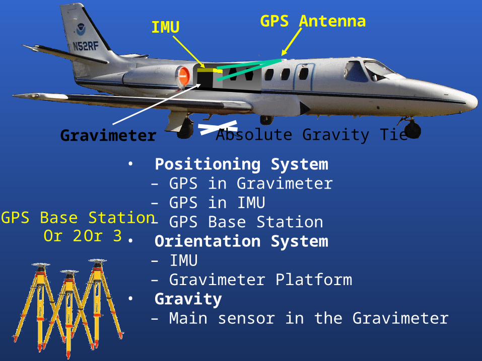
Eötvös Correction
East
Depends on:
•Speed
•Direction
•Latitude
•Altitude
The Vertical Component of:
•Coriolis Term
•Centrifugal of Airplane
West

Vertical Acceleration
•2nd Derivative of Height
•Mostly less than 10,000 mgal
•May have spikes to 50,000 mgal during data collection
•May have spikes to 100,000s mgal offline
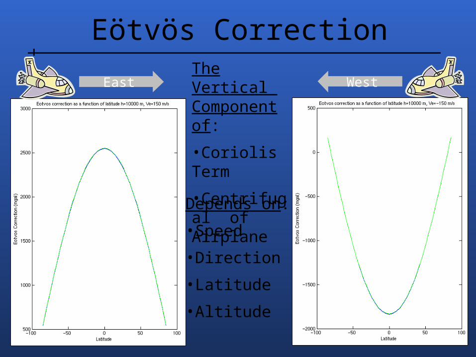
Off Level
• If the gravity meter is off level, gmeasured < g
• Two ways to correct– Derive off level angle from
platform horizontal accelerations
– Use the difference in the sum of accelerations between the airplane and the meter to derive the correction


1. Combine ST, BV, and CC with various manufacturer scale factors to get graw
2. Translate positions from the GPS antenna to the sensor position
3. Synchronize position and gravity measurements4. Remove Accelerations due to Airplane motion 5. Correct for slight deviation of sensor from level6. Correct for Instrument Drift and Tie to Absolute
Measurement7. Filter
How do we get there?


Thank You
Recommended


![Application planning [17 p/5792 w] {J. Albrecht} Chapter 7 ... · Chapter 7 – Application planning [17 p/5792 w] {J. Albrecht} thorough investigation of the cognitive aspects of](https://img.pdfslide.net/doc/110x75/6066b2a04b04485c736444ac/application-planning-17-p5792-w-j-albrecht-chapter-7-chapter-7-a-application.jpg)