Downtown Development Authority/City of Fort Collins, CO Quiet Zone Study
Appendix
APPENDIX A U.S. DOT CROSSING INVENTORY SUMMARY SHEETS

U.S. DOT - CROSSING INVENTORY INFORMATION
Crossing No.: 906295A Effective Begin-Date of Record:
Part I Location and Classification of Crossing
Railroad:
Division:
Subdivision:
State:
County:
County Map Ref. No.:
City:
Highway Type & No.:
Street or Road Name:
RailRoad I.D. No.:
Nearest RR Timetable Stn:
Branch or Line Name:
Railroad Milepost:
Part II Railroad Information
Union Pacific RR Co. [UP ]
DENVER
FT.COLLINS SUB
CO
LARIMER
LARIMER S2
LINCOLN AVE
FAU5062
FT COLLINS
FT COLLINS BR.
0031.72
Number of Daily Train Movements:
Day Thru:
Less Than One Movement Per Day:
Total Trains: Total Switching: 1
No
3 1
Maximum Time Table Speed: 10Typical Speed Range Over Crossing: From to mph5 10
Type and Number of Tracks: Main: Other:
1 0
Does Another RR Operate a Separate Track at Crossing? No
Does Another RR Operate Over Your Track at Crossing? No
06/30/03
FORT COLLINS
AS OF 2/18/2009
Lat/Long Source: Actual
Type and Positiion: Public At Grade
Update Reason: Changed Crossing
Initiating Agency Railroad
End-Date of Record:
In
HSR Corridor ID:
Latitude: 40.5874667
Longitude: -105.0712250
Parent Railroad:
Crossing Owner:
ENS Sign Installed:
Passenger Service:
Avg Passenger Train Count: 0
Adjacent Crossing with Separate Number:
Private Crossing Information:
Category:
Specify Signs:
Railroad Use:
ST/RR A
ST/RR B
ST/RR C
ST/RR D
State Use:
Narrative:
Emergency Contact: (800)848-8715 Railroad Contact: State Contact:
Specify:
UP
Specify Signals:
Quiet Zone: No
Public Access: Unknown

U.S. DOT - CROSSING INVENTORY INFORMATIONCrossing 906295A
Part III: Traffic Control Device Information
Type of Development: Smallest Crossing Angle:
Number of Traffic Lanes Crossing Railroad:
Are Truck Pullout Lanes Present?
Is Highway Paved?
Pavement Markings:
Crossing Surface:
Does Track Run Down a Street?
Nearby Intersecting Highway?
Part IV: Physical Characteristics
Highway System:
Is Crossing on State Highway System:
Functional Classification of Road at Crossing:
Annual Average Daily Traffic (AADT):
Estimated Percent Trucks:
2
Urban CollectorOther FA Highway - Not NHS
004850
13
Continued
Industrial 60 to 90 Degrees
No
Yes
Stop Lines and RR Xing Symbols
Yes
Concrete
No
Less than 75 feet
No
Effective Begin-Date of Record: 06/30/03
End-Date of Record:
Crossbucks: Highway Stop Signs:
Other Signs:
Train Activated Devices:
Special Warning Devices Not Train Activated:
Type of Train Detection:
Track Equipped with Train Signals?
0 0
0
0
Specify:
DC/AFO
No
Gates: 3
Mast Mounted FL: 0
Highway Traffic Signals: 0 Wigwags: 0 Bells: 3
Other Flashing Lights:
Cantilevered FL (Over): 0 Cantilevered FL (Not over): 0
0
Signs:
Advanced Warning: Hump Crossing Sign:
4 Quad or Full Barrier:
Total Number FL Pairs: 0
Specify Other Flashing Lights:
Other Train Activated Warning Devices:
Is Commercial Power Yes
Channelization:
Traffic Light Interconnection/Preemption:
Is it Signalized?
Is Crossing Illuminated?
Part V: Highway Information
AADT Year: 1994
Posted Highway Speed: 0
Avg. No of School Buses per Day: 0
If Other:

U.S. DOT - CROSSING INVENTORY INFORMATION
Crossing No.: 906296G Effective Begin-Date of Record:
Part I Location and Classification of Crossing
Railroad:
Division:
Subdivision:
State:
County:
County Map Ref. No.:
City:
Highway Type & No.:
Street or Road Name:
RailRoad I.D. No.:
Nearest RR Timetable Stn:
Branch or Line Name:
Railroad Milepost:
Part II Railroad Information
Union Pacific RR Co. [UP ]
CENTRAL REGION
WYOMING DIV.
CO
LARIMER
LARIMER S2
LINDEN EOJEFFERSN
FAU5049
FT COLLINS
FT COLLINS BR.
0031.93
Number of Daily Train Movements:
Day Thru:
Less Than One Movement Per Day:
Total Trains: Total Switching: 1
No
2 0
Maximum Time Table Speed: 10Typical Speed Range Over Crossing: From to mph5 10
Type and Number of Tracks: Main: Other:
1 1
Does Another RR Operate a Separate Track at Crossing? No
Does Another RR Operate Over Your Track at Crossing? No
06/30/03
FORT COLLINS
AS OF 2/18/2009
Lat/Long Source: Actual
Type and Positiion: Public At Grade
Update Reason: Changed Crossing
Initiating Agency Railroad
End-Date of Record:
In
HSR Corridor ID:
Latitude: 40.5893006
Longitude: -105.0738750
Parent Railroad:
Crossing Owner:
ENS Sign Installed:
Passenger Service:
Avg Passenger Train Count: 0
Adjacent Crossing with Separate Number:
Private Crossing Information:
Category:
Specify Signs:
Railroad Use:
ST/RR A
ST/RR B
ST/RR C
ST/RR D
State Use:
Narrative:
Emergency Contact: (800)848-8715 Railroad Contact: State Contact:
Specify: SIDE
UP
Specify Signals:
Quiet Zone: No
Public Access: Unknown

U.S. DOT - CROSSING INVENTORY INFORMATIONCrossing 906296G
Part III: Traffic Control Device Information
Type of Development: Smallest Crossing Angle:
Number of Traffic Lanes Crossing Railroad:
Are Truck Pullout Lanes Present?
Is Highway Paved?
Pavement Markings:
Crossing Surface:
Does Track Run Down a Street?
Nearby Intersecting Highway?
Part IV: Physical Characteristics
Highway System:
Is Crossing on State Highway System:
Functional Classification of Road at Crossing:
Annual Average Daily Traffic (AADT):
Estimated Percent Trucks:
2
Urban CollectorOther FA Highway - Not NHS
002800
05
Continued
Industrial 60 to 90 Degrees
No
Yes
No Markings
Yes
Concrete and Rubber
No
Less than 75 feet
No
Effective Begin-Date of Record: 06/30/03
End-Date of Record:
Crossbucks: Highway Stop Signs:
Other Signs:
Train Activated Devices:
Special Warning Devices Not Train Activated:
Type of Train Detection:
Track Equipped with Train Signals?
1 0
0
0
Specify:
DC/AFO
No
Gates: 3
Mast Mounted FL: 2
Highway Traffic Signals: 0 Wigwags: 0 Bells: 2
Other Flashing Lights:
Cantilevered FL (Over): 0 Cantilevered FL (Not over): 0
0
Signs:
Advanced Warning: Hump Crossing Sign:
4 Quad or Full Barrier:
Total Number FL Pairs: 0
Specify Other Flashing Lights:
Other Train Activated Warning Devices:
Is Commercial Power Yes
Channelization:
Traffic Light Interconnection/Preemption:
Is it Signalized?
Is Crossing Illuminated?
Part V: Highway Information
AADT Year: 1994
Posted Highway Speed: 0
Avg. No of School Buses per Day: 0
If Other:

U.S. DOT - CROSSING INVENTORY INFORMATION
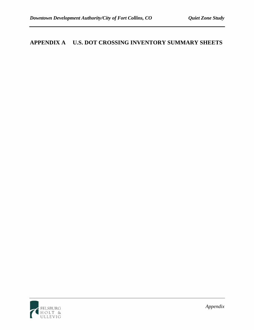
Crossing No.: 244644C Effective Begin-Date of Record:
Part I Location and Classification of Crossing
Railroad:
Division:
Subdivision:
State:
County:
County Map Ref. No.:
City:
Highway Type & No.:
Street or Road Name:
RailRoad I.D. No.:
Nearest RR Timetable Stn:
Branch or Line Name:
Railroad Milepost:
Part II Railroad Information
BNSF Rwy Co. [BNSF]
COLORADO
FRONT RANGE
CO
LARIMER
LARIMER S2
LINDEN ST
FAU50490476
FT COLLINS
DEN UD-WENDOVER
0075.09
Number of Daily Train Movements:
Day Thru:
Less Than One Movement Per Day:
Total Trains: Total Switching: 8
No
15 0
Maximum Time Table Speed: 20Typical Speed Range Over Crossing: From to mph1 20
Type and Number of Tracks: Main: Other:
1 0
Does Another RR Operate a Separate Track at Crossing? No
Does Another RR Operate Over Your Track at Crossing? No
09/20/06
FORT COLLINS
AS OF 2/18/2009
Lat/Long Source: Actual
Type and Positiion: Public At Grade
Update Reason: Changed Crossing
Initiating Agency Railroad
End-Date of Record:
In
HSR Corridor ID:
Latitude: 40.5956920
Longitude: -105.0687340
Parent Railroad:
Crossing Owner:
ENS Sign Installed:
Passenger Service: None
Avg Passenger Train Count: 0
Adjacent Crossing with Separate Number:
Private Crossing Information:
Category:
Specify Signs:
Railroad Use:
ST/RR A
ST/RR B
ST/RR C
ST/RR D
State Use:
Narrative:
Emergency Contact: (800)832-5452 Railroad Contact: (913)551-4540 State Contact:
Specify:
BNSF
Specify Signals:
Quiet Zone: No
Public Access:
U.S. DOT - CROSSING INVENTORY INFORMATIONCrossing 244644C
Part III: Traffic Control Device Information
Type of Development: Smallest Crossing Angle:
Number of Traffic Lanes Crossing Railroad:
Are Truck Pullout Lanes Present?
Is Highway Paved?
Pavement Markings:
Crossing Surface:
Does Track Run Down a Street?
Nearby Intersecting Highway?
Part IV: Physical Characteristics
Highway System:
Is Crossing on State Highway System:
Functional Classification of Road at Crossing:
Annual Average Daily Traffic (AADT):
Estimated Percent Trucks:
2
Urban CollectorOther FA Highway - Not NHS
001550
09
Continued
Commercial 60 to 90 Degrees
No
Yes
Stop Lines and RR Xing Symbols
Yes
Concrete
No
N/A
No
Effective Begin-Date of Record: 09/20/06
End-Date of Record:
Crossbucks: Highway Stop Signs:
Other Signs:
Train Activated Devices:
Special Warning Devices Not Train Activated:
Type of Train Detection:
Track Equipped with Train Signals?
0 0
0
0
Specify:
DC/AFO
No
Gates: 2
Mast Mounted FL: 2
Highway Traffic Signals: 0 Wigwags: 0 Bells: 1
Other Flashing Lights:
Cantilevered FL (Over): 0 Cantilevered FL (Not over): 0
0
Signs:
Advanced Warning: Hump Crossing Sign:
4 Quad or Full Barrier:
Total Number FL Pairs: 0
Specify Other Flashing Lights:
Other Train Activated Warning Devices:
Is Commercial Power Yes
Channelization:
Traffic Light Interconnection/Preemption:
Is it Signalized?
Is Crossing Illuminated?
Part V: Highway Information
AADT Year: 1989
Posted Highway Speed: 0
Avg. No of School Buses per Day: 0
If Other:

U.S. DOT - CROSSING INVENTORY INFORMATION
Crossing No.: 244643V Effective Begin-Date of Record:
Part I Location and Classification of Crossing
Railroad:
Division:
Subdivision:
State:
County:
County Map Ref. No.:
City:
Highway Type & No.:
Street or Road Name:
RailRoad I.D. No.:
Nearest RR Timetable Stn:
Branch or Line Name:
Railroad Milepost:
Part II Railroad Information
BNSF Rwy Co. [BNSF]
COLORADO
FRONT RANGE
CO
LARIMER
LARIMER S2
N COLLEGE AVE
FAP 2870476
FT COLLINS
DEN UD-WENDOVER
0074.63
Number of Daily Train Movements:
Day Thru:
Less Than One Movement Per Day:
Total Trains: Total Switching: 8
No
15 0
Maximum Time Table Speed: 49Typical Speed Range Over Crossing: From to mph1 49
Type and Number of Tracks: Main: Other:
1 0
Does Another RR Operate a Separate Track at Crossing? No
Does Another RR Operate Over Your Track at Crossing? No
09/20/06
FORT COLLINS
AS OF 1/21/2009
Lat/Long Source: Actual
Type and Positiion: Public At Grade
Update Reason: Changed Crossing
Initiating Agency Railroad
End-Date of Record:
In
HSR Corridor ID:
Latitude: 40.5930960
Longitude: -105.0767460
Parent Railroad:
Crossing Owner:
ENS Sign Installed:
Passenger Service: None
Avg Passenger Train Count: 0
Adjacent Crossing with Separate Number:
Private Crossing Information:
Category:
Specify Signs:
Railroad Use:
ST/RR A
ST/RR B
ST/RR C
ST/RR D
State Use:
Narrative:
Emergency Contact: (800)832-5452 Railroad Contact: (913)551-4540 State Contact:
Specify:
BNSF
Specify Signals:
Quiet Zone: No
Public Access:

U.S. DOT - CROSSING INVENTORY INFORMATIONCrossing 244643V
Part III: Traffic Control Device Information
Type of Development: Smallest Crossing Angle:
Number of Traffic Lanes Crossing Railroad:
Are Truck Pullout Lanes Present?
Is Highway Paved?
Pavement Markings:
Crossing Surface:
Does Track Run Down a Street?
Nearby Intersecting Highway?
Part IV: Physical Characteristics
Highway System:
Is Crossing on State Highway System:
Functional Classification of Road at Crossing:
Annual Average Daily Traffic (AADT):
Estimated Percent Trucks:
4
Urban Other Principal Other National Highway
020800
09
Continued
Commercial 60 to 90 Degrees
No
Yes
Stop Lines and RR Xing Symbols
Yes
Rubber
No
N/A
Yes
Effective Begin-Date of Record: 09/20/06
End-Date of Record:
Crossbucks: Highway Stop Signs:
Other Signs:
Train Activated Devices:
Special Warning Devices Not Train Activated:
Type of Train Detection:
Track Equipped with Train Signals?
0 0
0
0
Specify:
Constant Warning Time
No
Gates: 4
Mast Mounted FL: 4
Highway Traffic Signals: 4 Wigwags: 0 Bells: 2
Other Flashing Lights:
Cantilevered FL (Over): 0 Cantilevered FL (Not over): 0
0
Signs:
Advanced Warning: Hump Crossing Sign:
4 Quad or Full Barrier:
Total Number FL Pairs: 0
Specify Other Flashing Lights:
Other Train Activated Warning Devices:
Is Commercial Power Yes
Channelization:
Traffic Light Interconnection/Preemption:
Simultaneous Preemption
Is it Signalized?
Is Crossing Illuminated?
Part V: Highway Information
AADT Year: 1996
Posted Highway Speed: 0
Avg. No of School Buses per Day: 0
If Other:

U.S. DOT - CROSSING INVENTORY INFORMATION
Crossing No.: 244642N Effective Begin-Date of Record:
Part I Location and Classification of Crossing
Railroad:
Division:
Subdivision:
State:
County:
County Map Ref. No.:
City:
Highway Type & No.:
Street or Road Name:
RailRoad I.D. No.:
Nearest RR Timetable Stn:
Branch or Line Name:
Railroad Milepost:
Part II Railroad Information
BNSF Rwy Co. [BNSF]
COLORADO
FRONT RANGE
CO
LARIMER
LARIMR S2
CHERRY ST
0476
FT COLLINS
DEN UD-WENDOVER
0074.52
Number of Daily Train Movements:
Day Thru:
Less Than One Movement Per Day:
Total Trains: Total Switching: 8
No
15 0
Maximum Time Table Speed: 49Typical Speed Range Over Crossing: From to mph1 49
Type and Number of Tracks: Main: Other:
1 0
Does Another RR Operate a Separate Track at Crossing? No
Does Another RR Operate Over Your Track at Crossing? No
09/20/06
FORT COLLINS
AS OF 2/18/2009
Lat/Long Source: Actual
Type and Positiion: Public At Grade
Update Reason: Changed Crossing
Initiating Agency Railroad
End-Date of Record:
In
HSR Corridor ID:
Latitude: 40.5921610
Longitude: -105.0783300
Parent Railroad:
Crossing Owner:
ENS Sign Installed:
Passenger Service: None
Avg Passenger Train Count: 0
Adjacent Crossing with Separate Number:
Private Crossing Information:
Category:
Specify Signs:
Railroad Use:
ST/RR A
ST/RR B
ST/RR C
ST/RR D
State Use:
Narrative:
Emergency Contact: (800)832-5452 Railroad Contact: (913)551-4540 State Contact:
Specify:
BNSF
Specify Signals:
Quiet Zone: No
Public Access:

U.S. DOT - CROSSING INVENTORY INFORMATIONCrossing 244642N
Part III: Traffic Control Device Information
Type of Development: Smallest Crossing Angle:
Number of Traffic Lanes Crossing Railroad:
Are Truck Pullout Lanes Present?
Is Highway Paved?
Pavement Markings:
Crossing Surface:
Does Track Run Down a Street?
Nearby Intersecting Highway?
Part IV: Physical Characteristics
Highway System:
Is Crossing on State Highway System:
Functional Classification of Road at Crossing:
Annual Average Daily Traffic (AADT):
Estimated Percent Trucks:
4
Urban Minor ArterialNon-Federal-aid
010000
05
Continued
Commercial 30 to 59 Degrees
No
Yes
Stop Lines and RR Xing Symbols
Yes
Concrete
No
Less than 75 feet
No
Effective Begin-Date of Record: 09/20/06
End-Date of Record:
Crossbucks: Highway Stop Signs:
Other Signs:
Train Activated Devices:
Special Warning Devices Not Train Activated:
Type of Train Detection:
Track Equipped with Train Signals?
0 0
0
0
Specify:
Constant Warning Time
Yes
Gates: 4
Mast Mounted FL: 4
Highway Traffic Signals: 0 Wigwags: 0 Bells: 2
Other Flashing Lights:
Cantilevered FL (Over): 0 Cantilevered FL (Not over): 0
0
Signs:
Advanced Warning: Hump Crossing Sign:
4 Quad or Full Barrier:
Total Number FL Pairs: 0
Specify Other Flashing Lights:
Other Train Activated Warning Devices:
Is Commercial Power Yes
Channelization:
Traffic Light Interconnection/Preemption:
Is it Signalized?
Is Crossing Illuminated?
Part V: Highway Information
AADT Year: 1994
Posted Highway Speed: 0
Avg. No of School Buses per Day: 0
If Other:

U.S. DOT - CROSSING INVENTORY INFORMATION
Crossing No.: 244641G Effective Begin-Date of Record:
Part I Location and Classification of Crossing
Railroad:
Division:
Subdivision:
State:
County:
County Map Ref. No.:
City:
Highway Type & No.:
Street or Road Name:
RailRoad I.D. No.:
Nearest RR Timetable Stn:
Branch or Line Name:
Railroad Milepost:
Part II Railroad Information
BNSF Rwy Co. [BNSF]
COLORADO
FRONT RANGE
CO
LARIMER
LARIMR S2
MAPLE ST
0476
FT COLLINS
DEN UD-WENDOVER
0074.42
Number of Daily Train Movements:
Day Thru:
Less Than One Movement Per Day:
Total Trains: Total Switching: 8
No
15 0
Maximum Time Table Speed: 49Typical Speed Range Over Crossing: From to mph1 49
Type and Number of Tracks: Main: Other:
1 1
Does Another RR Operate a Separate Track at Crossing? No
Does Another RR Operate Over Your Track at Crossing? No
09/20/06
FORT COLLINS
AS OF 2/18/2009
Lat/Long Source: Actual
Type and Positiion: Public At Grade
Update Reason: Changed Crossing
Initiating Agency Railroad
End-Date of Record:
In
HSR Corridor ID:
Latitude: 40.5907930
Longitude: -105.0788770
Parent Railroad:
Crossing Owner:
ENS Sign Installed:
Passenger Service: None
Avg Passenger Train Count: 0
Adjacent Crossing with Separate Number:
Private Crossing Information:
Category:
Specify Signs:
Railroad Use:
ST/RR A
ST/RR B
ST/RR C
ST/RR D
State Use:
Narrative:
Emergency Contact: (800)832-5452 Railroad Contact: (913)551-4540 State Contact:
Specify: YARD
BNSF
Specify Signals:
Quiet Zone: No
Public Access:

U.S. DOT - CROSSING INVENTORY INFORMATIONCrossing 244641G
Part III: Traffic Control Device Information
Type of Development: Smallest Crossing Angle:
Number of Traffic Lanes Crossing Railroad:
Are Truck Pullout Lanes Present?
Is Highway Paved?
Pavement Markings:
Crossing Surface:
Does Track Run Down a Street?
Nearby Intersecting Highway?
Part IV: Physical Characteristics
Highway System:
Is Crossing on State Highway System:
Functional Classification of Road at Crossing:
Annual Average Daily Traffic (AADT):
Estimated Percent Trucks:
4
Urban LocalNon-Federal-aid
003100
00
Continued
Commercial 60 to 90 Degrees
No
Yes
Stop Lines and RR Xing Symbols
Yes
Concrete
Yes
N/A
No
Effective Begin-Date of Record: 09/20/06
End-Date of Record:
Crossbucks: Highway Stop Signs:
Other Signs:
Train Activated Devices:
Special Warning Devices Not Train Activated:
Type of Train Detection:
Track Equipped with Train Signals?
0 0
2
0
TWO TRACKS
Specify:
DC/AFO
Yes
Gates: 0
Mast Mounted FL: 2
Highway Traffic Signals: 0 Wigwags: 0 Bells: 2
Other Flashing Lights:
Cantilevered FL (Over): 0 Cantilevered FL (Not over): 0
0
Signs:
Advanced Warning: Hump Crossing Sign:
4 Quad or Full Barrier:
Total Number FL Pairs: 0
Specify Other Flashing Lights:
Other Train Activated Warning Devices:
Is Commercial Power Yes
Channelization:
Traffic Light Interconnection/Preemption:
Is it Signalized?
Is Crossing Illuminated?
Part V: Highway Information
AADT Year: 1989
Posted Highway Speed: 0
Avg. No of School Buses per Day: 0
If Other:

U.S. DOT - CROSSING INVENTORY INFORMATION
Crossing No.: 244640A Effective Begin-Date of Record:
Part I Location and Classification of Crossing
Railroad:
Division:
Subdivision:
State:
County:
County Map Ref. No.:
City:
Highway Type & No.:
Street or Road Name:
RailRoad I.D. No.:
Nearest RR Timetable Stn:
Branch or Line Name:
Railroad Milepost:
Part II Railroad Information
BNSF Rwy Co. [BNSF]
COLORADO
FRONT RANGE
CO
LARIMER
LARIMR S2
LAPORTE AVE
FAU50540476
FT COLLINS
DEN UD-WENDOVER
0074.30
Number of Daily Train Movements:
Day Thru:
Less Than One Movement Per Day:
Total Trains: Total Switching: 8
No
15 0
Maximum Time Table Speed: 49Typical Speed Range Over Crossing: From to mph1 49
Type and Number of Tracks: Main: Other:
1 0
Does Another RR Operate a Separate Track at Crossing? No
Does Another RR Operate Over Your Track at Crossing? No
09/20/06
FORT COLLINS
AS OF 2/18/2009
Lat/Long Source: Actual
Type and Positiion: Public At Grade
Update Reason: Changed Crossing
Initiating Agency Railroad
End-Date of Record:
In
HSR Corridor ID:
Latitude: 40.5889400
Longitude: -105.0788930
Parent Railroad:
Crossing Owner:
ENS Sign Installed:
Passenger Service: None
Avg Passenger Train Count: 0
Adjacent Crossing with Separate Number:
Private Crossing Information:
Category:
Specify Signs:
Railroad Use:
ST/RR A
ST/RR B
ST/RR C
ST/RR D
State Use:
Narrative:
Emergency Contact: (800)832-5452 Railroad Contact: (913)551-4540 State Contact:
Specify:
BNSF
Specify Signals:
Quiet Zone: No
Public Access:

U.S. DOT - CROSSING INVENTORY INFORMATIONCrossing 244640A
Part III: Traffic Control Device Information
Type of Development: Smallest Crossing Angle:
Number of Traffic Lanes Crossing Railroad:
Are Truck Pullout Lanes Present?
Is Highway Paved?
Pavement Markings:
Crossing Surface:
Does Track Run Down a Street?
Nearby Intersecting Highway?
Part IV: Physical Characteristics
Highway System:
Is Crossing on State Highway System:
Functional Classification of Road at Crossing:
Annual Average Daily Traffic (AADT):
Estimated Percent Trucks:
4
Urban Minor ArterialOther FA Highway - Not NHS
007400
05
Continued
Commercial 60 to 90 Degrees
No
Yes
Stop Lines and RR Xing Symbols
Yes
Concrete
Yes
Less than 75 feet
No
Effective Begin-Date of Record: 09/20/06
End-Date of Record:
Crossbucks: Highway Stop Signs:
Other Signs:
Train Activated Devices:
Special Warning Devices Not Train Activated:
Type of Train Detection:
Track Equipped with Train Signals?
0 0
0
0
Specify:
DC/AFO
Yes
Gates: 0
Mast Mounted FL: 2
Highway Traffic Signals: 2 Wigwags: 0 Bells: 2
Other Flashing Lights:
Cantilevered FL (Over): 0 Cantilevered FL (Not over): 0
0
Signs:
Advanced Warning: Hump Crossing Sign:
4 Quad or Full Barrier:
Total Number FL Pairs: 0
Specify Other Flashing Lights:
Other Train Activated Warning Devices:
Is Commercial Power Yes
Channelization:
Traffic Light Interconnection/Preemption:
Simultaneous Preemption
Is it Signalized?
Is Crossing Illuminated?
Part V: Highway Information
AADT Year: 1994
Posted Highway Speed: 0
Avg. No of School Buses per Day: 0
If Other:
U.S. DOT - CROSSING INVENTORY INFORMATION
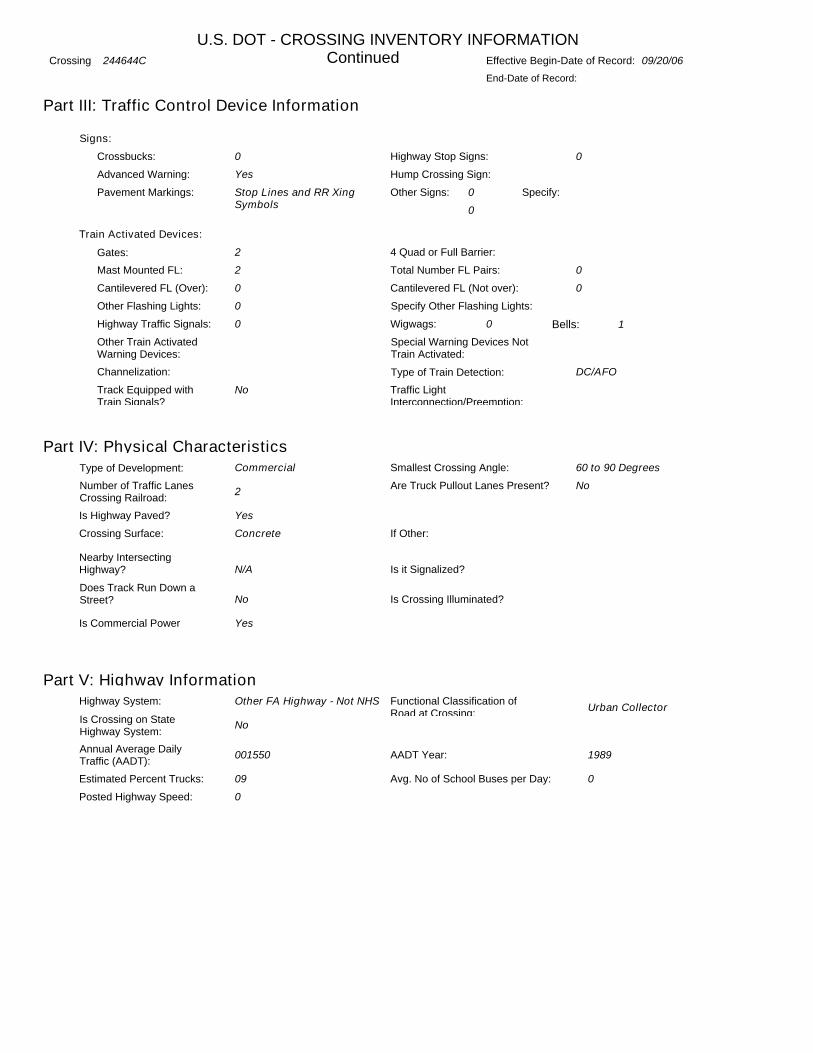
Crossing No.: 244639F Effective Begin-Date of Record:
Part I Location and Classification of Crossing
Railroad:
Division:
Subdivision:
State:
County:
County Map Ref. No.:
City:
Highway Type & No.:
Street or Road Name:
RailRoad I.D. No.:
Nearest RR Timetable Stn:
Branch or Line Name:
Railroad Milepost:
Part II Railroad Information
BNSF Rwy Co. [BNSF]
COLORADO
FRONT RANGE
CO
LARIMER
LARIMR S2
MOUNTAIN AVE
FAU50500476
FT COLLINS
DEN UD-WENDOVER
0074.16
Number of Daily Train Movements:
Day Thru:
Less Than One Movement Per Day:
Total Trains: Total Switching: 8
No
15 0
Maximum Time Table Speed: 49Typical Speed Range Over Crossing: From to mph1 49
Type and Number of Tracks: Main: Other:
1 0
Does Another RR Operate a Separate Track at Crossing? No
Does Another RR Operate Over Your Track at Crossing? No
09/20/06
FORT COLLINS
AS OF 2/18/2009
Lat/Long Source: Actual
Type and Positiion: Public At Grade
Update Reason: Changed Crossing
Initiating Agency Railroad
End-Date of Record:
In
HSR Corridor ID:
Latitude: 40.5870320
Longitude: -105.0789100
Parent Railroad:
Crossing Owner:
ENS Sign Installed:
Passenger Service: None
Avg Passenger Train Count: 0
Adjacent Crossing with Separate Number:
Private Crossing Information:
Category:
Specify Signs:
Railroad Use:
ST/RR A
ST/RR B
ST/RR C
ST/RR D
State Use:
Narrative:
Emergency Contact: (800)832-5452 Railroad Contact: (913)551-4540 State Contact:
Specify:
BNSF
Specify Signals:
Quiet Zone: No
Public Access:

U.S. DOT - CROSSING INVENTORY INFORMATIONCrossing 244639F
Part III: Traffic Control Device Information
Type of Development: Smallest Crossing Angle:
Number of Traffic Lanes Crossing Railroad:
Are Truck Pullout Lanes Present?
Is Highway Paved?
Pavement Markings:
Crossing Surface:
Does Track Run Down a Street?
Nearby Intersecting Highway?
Part IV: Physical Characteristics
Highway System:
Is Crossing on State Highway System:
Functional Classification of Road at Crossing:
Annual Average Daily Traffic (AADT):
Estimated Percent Trucks:
2
Urban CollectorOther FA Highway - Not NHS
007600
05
Continued
Commercial 60 to 90 Degrees
No
Yes
Stop Lines and RR Xing Symbols
Yes
Concrete
Yes
Less than 75 feet
No
Effective Begin-Date of Record: 09/20/06
End-Date of Record:
Crossbucks: Highway Stop Signs:
Other Signs:
Train Activated Devices:
Special Warning Devices Not Train Activated:
Type of Train Detection:
Track Equipped with Train Signals?
0 0
0
0
Specify:
DC/AFO
Yes
Gates: 0
Mast Mounted FL: 2
Highway Traffic Signals: 0 Wigwags: 0 Bells: 2
Other Flashing Lights:
Cantilevered FL (Over): 0 Cantilevered FL (Not over): 0
0
Signs:
Advanced Warning: Hump Crossing Sign:
4 Quad or Full Barrier:
Total Number FL Pairs: 0
Specify Other Flashing Lights:
Other Train Activated Warning Devices:
Is Commercial Power Yes
Channelization:
Traffic Light Interconnection/Preemption:
Simultaneous Preemption
Is it Signalized?
Is Crossing Illuminated?
Part V: Highway Information
AADT Year: 1994
Posted Highway Speed: 0
Avg. No of School Buses per Day: 0
If Other:

U.S. DOT - CROSSING INVENTORY INFORMATION
Crossing No.: 244638Y Effective Begin-Date of Record:
Part I Location and Classification of Crossing
Railroad:
Division:
Subdivision:
State:
County:
County Map Ref. No.:
City:
Highway Type & No.:
Street or Road Name:
RailRoad I.D. No.:
Nearest RR Timetable Stn:
Branch or Line Name:
Railroad Milepost:
Part II Railroad Information
BNSF Rwy Co. [BNSF]
COLORADO
FRONT RANGE
CO
LARIMER
LARIMER S2
OAK ST
10476
FT COLLINS
DEN UD-WENDOVER
0074.06
Number of Daily Train Movements:
Day Thru:
Less Than One Movement Per Day:
Total Trains: Total Switching: 8
No
15 0
Maximum Time Table Speed: 49Typical Speed Range Over Crossing: From to mph1 49
Type and Number of Tracks: Main: Other:
1 0
Does Another RR Operate a Separate Track at Crossing? No
Does Another RR Operate Over Your Track at Crossing? No
09/20/06
FORT COLLINS
AS OF 2/18/2009
Lat/Long Source: Actual
Type and Positiion: Public At Grade
Update Reason: Changed Crossing
Initiating Agency Railroad
End-Date of Record:
In
HSR Corridor ID:
Latitude: 40.5856130
Longitude: -105.0789100
Parent Railroad:
Crossing Owner:
ENS Sign Installed:
Passenger Service: None
Avg Passenger Train Count: 0
Adjacent Crossing with Separate Number:
Private Crossing Information:
Category:
Specify Signs:
Railroad Use:
ST/RR A
ST/RR B
ST/RR C
ST/RR D
State Use:
Narrative:
Emergency Contact: (800)832-5452 Railroad Contact: (913)551-4540 State Contact:
Specify:
BNSF
Specify Signals:
Quiet Zone: No
Public Access:

U.S. DOT - CROSSING INVENTORY INFORMATIONCrossing 244638Y
Part III: Traffic Control Device Information
Type of Development: Smallest Crossing Angle:
Number of Traffic Lanes Crossing Railroad:
Are Truck Pullout Lanes Present?
Is Highway Paved?
Pavement Markings:
Crossing Surface:
Does Track Run Down a Street?
Nearby Intersecting Highway?
Part IV: Physical Characteristics
Highway System:
Is Crossing on State Highway System:
Functional Classification of Road at Crossing:
Annual Average Daily Traffic (AADT):
Estimated Percent Trucks:
2
Urban LocalNon-Federal-aid
003500
05
Continued
Commercial 60 to 90 Degrees
No
Yes
Stop Lines and RR Xing Symbols
Yes
Concrete
Yes
Less than 75 feet
No
Effective Begin-Date of Record: 09/20/06
End-Date of Record:
Crossbucks: Highway Stop Signs:
Other Signs:
Train Activated Devices:
Special Warning Devices Not Train Activated:
Type of Train Detection:
Track Equipped with Train Signals?
0 2
0
0
Specify:
None
No
Gates: 0
Mast Mounted FL: 0
Highway Traffic Signals: 0 Wigwags: 0 Bells: 0
Other Flashing Lights:
Cantilevered FL (Over): 0 Cantilevered FL (Not over): 0
0
Signs:
Advanced Warning: Hump Crossing Sign:
4 Quad or Full Barrier:
Total Number FL Pairs: 0
Specify Other Flashing Lights:
Other Train Activated Warning Devices:
Is Commercial Power Yes
Channelization:
Traffic Light Interconnection/Preemption:
Simultaneous Preemption
Is it Signalized?
Is Crossing Illuminated?
Part V: Highway Information
AADT Year: 1994
Posted Highway Speed: 0
Avg. No of School Buses per Day: 0
If Other:

U.S. DOT - CROSSING INVENTORY INFORMATION
Crossing No.: 244637S Effective Begin-Date of Record:
Part I Location and Classification of Crossing
Railroad:
Division:
Subdivision:
State:
County:
County Map Ref. No.:
City:
Highway Type & No.:
Street or Road Name:
RailRoad I.D. No.:
Nearest RR Timetable Stn:
Branch or Line Name:
Railroad Milepost:
Part II Railroad Information
BNSF Rwy Co. [BNSF]
COLORADO
FRONT RANGE
CO
LARIMER
LARIMR S2
OLIVE ST
0476
FT COLLINS
DEN UD-WENDOVER
0073.97
Number of Daily Train Movements:
Day Thru:
Less Than One Movement Per Day:
Total Trains: Total Switching: 8
No
15 0
Maximum Time Table Speed: 49Typical Speed Range Over Crossing: From to mph1 49
Type and Number of Tracks: Main: Other:
1 0
Does Another RR Operate a Separate Track at Crossing? No
Does Another RR Operate Over Your Track at Crossing? No
09/20/06
FORT COLLINS
AS OF 2/18/2009
Lat/Long Source: Actual
Type and Positiion: Public At Grade
Update Reason: Changed Crossing
Initiating Agency Railroad
End-Date of Record:
In
HSR Corridor ID:
Latitude: 40.5842290
Longitude: -105.0789110
Parent Railroad:
Crossing Owner:
ENS Sign Installed:
Passenger Service: None
Avg Passenger Train Count: 0
Adjacent Crossing with Separate Number:
Private Crossing Information:
Category:
Specify Signs:
Railroad Use:
ST/RR A
ST/RR B
ST/RR C
ST/RR D
State Use:
Narrative:
Emergency Contact: (800)832-5452 Railroad Contact: (913)551-4540 State Contact:
Specify:
BNSF
Specify Signals:
Quiet Zone: No
Public Access:

U.S. DOT - CROSSING INVENTORY INFORMATIONCrossing 244637S
Part III: Traffic Control Device Information
Type of Development: Smallest Crossing Angle:
Number of Traffic Lanes Crossing Railroad:
Are Truck Pullout Lanes Present?
Is Highway Paved?
Pavement Markings:
Crossing Surface:
Does Track Run Down a Street?
Nearby Intersecting Highway?
Part IV: Physical Characteristics
Highway System:
Is Crossing on State Highway System:
Functional Classification of Road at Crossing:
Annual Average Daily Traffic (AADT):
Estimated Percent Trucks:
4
Urban LocalNon-Federal-aid
002000
00
Continued
Commercial 60 to 90 Degrees
No
Yes
Stop Lines and RR Xing Symbols
Yes
Asphalt
Yes
Less than 75 feet
No
Effective Begin-Date of Record: 09/20/06
End-Date of Record:
Crossbucks: Highway Stop Signs:
Other Signs:
Train Activated Devices:
Special Warning Devices Not Train Activated:
Type of Train Detection:
Track Equipped with Train Signals?
0 0
0
0
Specify:
DC/AFO
No
Gates: 0
Mast Mounted FL: 2
Highway Traffic Signals: 0 Wigwags: 0 Bells: 2
Other Flashing Lights:
Cantilevered FL (Over): 0 Cantilevered FL (Not over): 0
0
Signs:
Advanced Warning: Hump Crossing Sign:
4 Quad or Full Barrier:
Total Number FL Pairs: 0
Specify Other Flashing Lights:
Other Train Activated Warning Devices:
Is Commercial Power Yes
Channelization:
Traffic Light Interconnection/Preemption:
Simultaneous Preemption
Is it Signalized?
Is Crossing Illuminated?
Part V: Highway Information
AADT Year: 1989
Posted Highway Speed: 0
Avg. No of School Buses per Day: 0
If Other:

U.S. DOT - CROSSING INVENTORY INFORMATION
Crossing No.: 244636K Effective Begin-Date of Record:
Part I Location and Classification of Crossing
Railroad:
Division:
Subdivision:
State:
County:
County Map Ref. No.:
City:
Highway Type & No.:
Street or Road Name:
RailRoad I.D. No.:
Nearest RR Timetable Stn:
Branch or Line Name:
Railroad Milepost:
Part II Railroad Information
BNSF Rwy Co. [BNSF]
COLORADO
FRONT RANGE
CO
LARIMER
LARIMR S2
MAGNOLIA ST
0476
FT COLLINS
DEN UD-WENDOVER
0073.87
Number of Daily Train Movements:
Day Thru:
Less Than One Movement Per Day:
Total Trains: Total Switching: 8
No
15 0
Maximum Time Table Speed: 49Typical Speed Range Over Crossing: From to mph1 49
Type and Number of Tracks: Main: Other:
1 0
Does Another RR Operate a Separate Track at Crossing? No
Does Another RR Operate Over Your Track at Crossing? No
09/20/06
FORT COLLINS
AS OF 2/18/2009
Lat/Long Source: Actual
Type and Positiion: Public At Grade
Update Reason: Changed Crossing
Initiating Agency Railroad
End-Date of Record:
In
HSR Corridor ID:
Latitude: 40.5828500
Longitude: -105.0789180
Parent Railroad:
Crossing Owner:
ENS Sign Installed:
Passenger Service: None
Avg Passenger Train Count: 0
Adjacent Crossing with Separate Number:
Private Crossing Information:
Category:
Specify Signs:
Railroad Use:
ST/RR A
ST/RR B
ST/RR C
ST/RR D
State Use:
Narrative:
Emergency Contact: (800)832-5452 Railroad Contact: (913)551-4540 State Contact:
Specify:
BNSF
Specify Signals:
Quiet Zone: No
Public Access:

U.S. DOT - CROSSING INVENTORY INFORMATIONCrossing 244636K
Part III: Traffic Control Device Information
Type of Development: Smallest Crossing Angle:
Number of Traffic Lanes Crossing Railroad:
Are Truck Pullout Lanes Present?
Is Highway Paved?
Pavement Markings:
Crossing Surface:
Does Track Run Down a Street?
Nearby Intersecting Highway?
Part IV: Physical Characteristics
Highway System:
Is Crossing on State Highway System:
Functional Classification of Road at Crossing:
Annual Average Daily Traffic (AADT):
Estimated Percent Trucks:
4
Urban LocalNon-Federal-aid
003800
10
Continued
Commercial 60 to 90 Degrees
No
Yes
Stop Lines
Yes
Asphalt
Yes
Less than 75 feet
No
Effective Begin-Date of Record: 09/20/06
End-Date of Record:
Crossbucks: Highway Stop Signs:
Other Signs:
Train Activated Devices:
Special Warning Devices Not Train Activated:
Type of Train Detection:
Track Equipped with Train Signals?
2 2
0
0
Specify:
None
No
Gates: 0
Mast Mounted FL: 0
Highway Traffic Signals: 0 Wigwags: 0 Bells: 0
Other Flashing Lights:
Cantilevered FL (Over): 0 Cantilevered FL (Not over): 0
0
Signs:
Advanced Warning: Hump Crossing Sign:
4 Quad or Full Barrier:
Total Number FL Pairs: 0
Specify Other Flashing Lights:
Other Train Activated Warning Devices:
Is Commercial Power Yes
Channelization:
Traffic Light Interconnection/Preemption:
Is it Signalized?
Is Crossing Illuminated?
Part V: Highway Information
AADT Year: 1989
Posted Highway Speed: 0
Avg. No of School Buses per Day: 0
If Other:

U.S. DOT - CROSSING INVENTORY INFORMATION
Crossing No.: 244635D Effective Begin-Date of Record:
Part I Location and Classification of Crossing
Railroad:
Division:
Subdivision:
State:
County:
County Map Ref. No.:
City:
Highway Type & No.:
Street or Road Name:
RailRoad I.D. No.:
Nearest RR Timetable Stn:
Branch or Line Name:
Railroad Milepost:
Part II Railroad Information
BNSF Rwy Co. [BNSF]
COLORADO
FRONT RANGE
CO
LARIMER
LARIMR S2
MULBERRY ST
FAU50460476
FT COLLINS
DEN UD-WENDOVER
0073.78
Number of Daily Train Movements:
Day Thru:
Less Than One Movement Per Day:
Total Trains: Total Switching: 8
No
15 0
Maximum Time Table Speed: 49Typical Speed Range Over Crossing: From to mph1 49
Type and Number of Tracks: Main: Other:
1 0
Does Another RR Operate a Separate Track at Crossing? No
Does Another RR Operate Over Your Track at Crossing? No
09/20/06
FORT COLLINS
AS OF 2/18/2009
Lat/Long Source: Actual
Type and Positiion: Public At Grade
Update Reason: Changed Crossing
Initiating Agency Railroad
End-Date of Record:
In
HSR Corridor ID:
Latitude: 40.5814940
Longitude: -105.0789240
Parent Railroad:
Crossing Owner:
ENS Sign Installed:
Passenger Service: None
Avg Passenger Train Count: 0
Adjacent Crossing with Separate Number:
Private Crossing Information:
Category:
Specify Signs:
Railroad Use:
ST/RR A
ST/RR B
ST/RR C
ST/RR D
State Use:
Narrative:
Emergency Contact: (800)832-5452 Railroad Contact: (913)551-4540 State Contact:
Specify:
BNSF
Specify Signals:
Quiet Zone: No
Public Access:

U.S. DOT - CROSSING INVENTORY INFORMATIONCrossing 244635D
Part III: Traffic Control Device Information
Type of Development: Smallest Crossing Angle:
Number of Traffic Lanes Crossing Railroad:
Are Truck Pullout Lanes Present?
Is Highway Paved?
Pavement Markings:
Crossing Surface:
Does Track Run Down a Street?
Nearby Intersecting Highway?
Part IV: Physical Characteristics
Highway System:
Is Crossing on State Highway System:
Functional Classification of Road at Crossing:
Annual Average Daily Traffic (AADT):
Estimated Percent Trucks:
5
Urban Minor ArterialOther FA Highway - Not NHS
014500
05
Continued
Commercial 60 to 90 Degrees
No
Yes
Stop Lines and RR Xing Symbols
Yes
Asphalt
Yes
Less than 75 feet
No
Effective Begin-Date of Record: 09/20/06
End-Date of Record:
Crossbucks: Highway Stop Signs:
Other Signs:
Train Activated Devices:
Special Warning Devices Not Train Activated:
Type of Train Detection:
Track Equipped with Train Signals?
0 0
0
0
Specify:
DC/AFO
Yes
Gates: 0
Mast Mounted FL: 2
Highway Traffic Signals: 0 Wigwags: 0 Bells: 2
Other Flashing Lights:
Cantilevered FL (Over): 0 Cantilevered FL (Not over): 0
0
Signs:
Advanced Warning: Hump Crossing Sign:
4 Quad or Full Barrier:
Total Number FL Pairs: 0
Specify Other Flashing Lights:
Other Train Activated Warning Devices:
Is Commercial Power Yes
Channelization:
Traffic Light Interconnection/Preemption:
Simultaneous Preemption
Is it Signalized?
Is Crossing Illuminated?
Part V: Highway Information
AADT Year: 1994
Posted Highway Speed: 0
Avg. No of School Buses per Day: 0
If Other:

U.S. DOT - CROSSING INVENTORY INFORMATION
Crossing No.: 244634W Effective Begin-Date of Record:
Part I Location and Classification of Crossing
Railroad:
Division:
Subdivision:
State:
County:
County Map Ref. No.:
City:
Highway Type & No.:
Street or Road Name:
RailRoad I.D. No.:
Nearest RR Timetable Stn:
Branch or Line Name:
Railroad Milepost:
Part II Railroad Information
BNSF Rwy Co. [BNSF]
COLORADO
FRONT RANGE
CO
LARIMER
LARIMR S2
MYRTLE ST
0476
FT COLLINS
DEN UD-WENDOVER
0073.68
Number of Daily Train Movements:
Day Thru:
Less Than One Movement Per Day:
Total Trains: Total Switching: 8
No
15 0
Maximum Time Table Speed: 49Typical Speed Range Over Crossing: From to mph1 49
Type and Number of Tracks: Main: Other:
1 0
Does Another RR Operate a Separate Track at Crossing? No
Does Another RR Operate Over Your Track at Crossing? No
09/20/06
FORT COLLINS
AS OF 2/18/2009
Lat/Long Source: Actual
Type and Positiion: Public At Grade
Update Reason: Changed Crossing
Initiating Agency Railroad
End-Date of Record:
In
HSR Corridor ID:
Latitude: 40.5801200
Longitude: -105.0789230
Parent Railroad:
Crossing Owner:
ENS Sign Installed:
Passenger Service: None
Avg Passenger Train Count: 0
Adjacent Crossing with Separate Number:
Private Crossing Information:
Category:
Specify Signs:
Railroad Use:
ST/RR A
ST/RR B
ST/RR C
ST/RR D
State Use:
Narrative:
Emergency Contact: (800)832-5452 Railroad Contact: (913)551-4540 State Contact:
Specify:
BNSF
Specify Signals:
Quiet Zone: No
Public Access:

U.S. DOT - CROSSING INVENTORY INFORMATIONCrossing 244634W
Part III: Traffic Control Device Information
Type of Development: Smallest Crossing Angle:
Number of Traffic Lanes Crossing Railroad:
Are Truck Pullout Lanes Present?
Is Highway Paved?
Pavement Markings:
Crossing Surface:
Does Track Run Down a Street?
Nearby Intersecting Highway?
Part IV: Physical Characteristics
Highway System:
Is Crossing on State Highway System:
Functional Classification of Road at Crossing:
Annual Average Daily Traffic (AADT):
Estimated Percent Trucks:
3
Urban LocalNon-Federal-aid
001000
05
Continued
Commercial 60 to 90 Degrees
No
Yes
Stop Lines and RR Xing Symbols
Yes
Asphalt
Yes
Less than 75 feet
No
Effective Begin-Date of Record: 09/20/06
End-Date of Record:
Crossbucks: Highway Stop Signs:
Other Signs:
Train Activated Devices:
Special Warning Devices Not Train Activated:
Type of Train Detection:
Track Equipped with Train Signals?
2 2
0
0
Specify:
None
No
Gates: 0
Mast Mounted FL: 0
Highway Traffic Signals: 0 Wigwags: 0 Bells: 0
Other Flashing Lights:
Cantilevered FL (Over): 0 Cantilevered FL (Not over): 0
0
Signs:
Advanced Warning: Hump Crossing Sign:
4 Quad or Full Barrier:
Total Number FL Pairs: 0
Specify Other Flashing Lights:
Other Train Activated Warning Devices:
Is Commercial Power Yes
Channelization:
Traffic Light Interconnection/Preemption:
Is it Signalized?
Is Crossing Illuminated?
Part V: Highway Information
AADT Year: 1989
Posted Highway Speed: 0
Avg. No of School Buses per Day: 0
If Other:

U.S. DOT - CROSSING INVENTORY INFORMATION
Crossing No.: 244633P Effective Begin-Date of Record:
Part I Location and Classification of Crossing
Railroad:
Division:
Subdivision:
State:
County:
County Map Ref. No.:
City:
Highway Type & No.:
Street or Road Name:
RailRoad I.D. No.:
Nearest RR Timetable Stn:
Branch or Line Name:
Railroad Milepost:
Part II Railroad Information
BNSF Rwy Co. [BNSF]
COLORADO
FRONT RANGE
CO
LARIMER
LARIMR S2
LAUREL ST
FAU50420476
FT COLLINS
DEN UD-WENDOVER
0073.54
Number of Daily Train Movements:
Day Thru:
Less Than One Movement Per Day:
Total Trains: Total Switching: 8
No
15 0
Maximum Time Table Speed: 49Typical Speed Range Over Crossing: From to mph1 49
Type and Number of Tracks: Main: Other:
1 0
Does Another RR Operate a Separate Track at Crossing? No
Does Another RR Operate Over Your Track at Crossing? No
09/20/06
FORT COLLINS
AS OF 2/18/2009
Lat/Long Source: Actual
Type and Positiion: Public At Grade
Update Reason: Changed Crossing
Initiating Agency Railroad
End-Date of Record:
In
HSR Corridor ID:
Latitude: 40.5780950
Longitude: -105.0789310
Parent Railroad:
Crossing Owner:
ENS Sign Installed:
Passenger Service: None
Avg Passenger Train Count: 0
Adjacent Crossing with Separate Number:
Private Crossing Information:
Category:
Specify Signs:
Railroad Use:
ST/RR A
ST/RR B
ST/RR C
ST/RR D
State Use:
Narrative:
Emergency Contact: (800)832-5452 Railroad Contact: (913)551-4540 State Contact:
Specify:
BNSF
Specify Signals:
Quiet Zone: No
Public Access:

U.S. DOT - CROSSING INVENTORY INFORMATIONCrossing 244633P
Part III: Traffic Control Device Information
Type of Development: Smallest Crossing Angle:
Number of Traffic Lanes Crossing Railroad:
Are Truck Pullout Lanes Present?
Is Highway Paved?
Pavement Markings:
Crossing Surface:
Does Track Run Down a Street?
Nearby Intersecting Highway?
Part IV: Physical Characteristics
Highway System:
Is Crossing on State Highway System:
Functional Classification of Road at Crossing:
Annual Average Daily Traffic (AADT):
Estimated Percent Trucks:
4
Urban Minor ArterialOther FA Highway - Not NHS
015800
05
Continued
Commercial 60 to 90 Degrees
No
Yes
Stop Lines
No
Asphalt
Yes
Less than 75 feet
No
Effective Begin-Date of Record: 09/20/06
End-Date of Record:
Crossbucks: Highway Stop Signs:
Other Signs:
Train Activated Devices:
Special Warning Devices Not Train Activated:
Type of Train Detection:
Track Equipped with Train Signals?
0 0
0
0
Specify:
DC/AFO
No
Gates: 0
Mast Mounted FL: 2
Highway Traffic Signals: 0 Wigwags: 0 Bells: 1
Other Flashing Lights:
Cantilevered FL (Over): 2 Cantilevered FL (Not over): 0
0
Signs:
Advanced Warning: Hump Crossing Sign:
4 Quad or Full Barrier:
Total Number FL Pairs: 0
Specify Other Flashing Lights:
Other Train Activated Warning Devices:
Is Commercial Power Yes
Channelization:
Traffic Light Interconnection/Preemption:
Is it Signalized?
Is Crossing Illuminated?
Part V: Highway Information
AADT Year: 1994
Posted Highway Speed: 0
Avg. No of School Buses per Day: 0
If Other:

Downtown Development Authority/City of Fort Collins, CO Quiet Zone Study
Appendix
APPENDIX B QUIET ZONE SUMMARY FLOWCHART

Chart 3 - Creating a New Quiet Zone or New Partial Quiet Zone using SSMs
Select crossings for inclusion in QZ
yesPvt xings with
public access and/or pedestrian xings
included?
no
SSMs at every public xing?
Send affirmation and updated inventory form to FRA every
4.5-5 yrs
QZRI < NSRT?
QZRI < RIWHOR
QZRI < NSRT?
no
no
yes
yes
yes
Obtain cooperation from
all affected jurisdictions
Conduct diagnostic team
review
Comply with diagnostic team's recommendations
Update National Inventory to
reflect existing conditions
Update National Inventory
Send affirmation and updated inventory form to FRA every
2.5-3 yrs
Update National Inventory
Qualified!
Qualified!
QZ must be at least 1/2 mile
long
Install gates and lights at all public
crossings
Install SSMs
yes
no
ASM use requires FRA
approval
Go to Chart 4A
no
Submit notification, silence horns, and install signage
at all crossings
Send affirmation and updated inventory form to FRA every
2.5-3 yrs
Qualified!
Disclaimer: This summary of the rule is for informational purposes only. Entities subject to the rule should refer to the rule text as published in the Federal Register on
August 17, 2006. Should any portion of this summary conflict with the rule, the language of the rule shall govern.
QZs established on thisbasis subject to annualreview
QZs established on the basis ofcomparison with NSRT aresubject to annual review
Submit Notification, silence horns, and install signage at all crossings
Submit notification, silence horns, and install signage
at all crossings
Submit Notice of Intent to Create
New QZ
Downtown Development Authority/City of Fort Collins, CO Quiet Zone Study
Appendix
APPENDIX C TRACK ISOLATION RENDERING

Downtown Development Authority/City of Fort Collins, CO Quiet Zone Study
Appendix
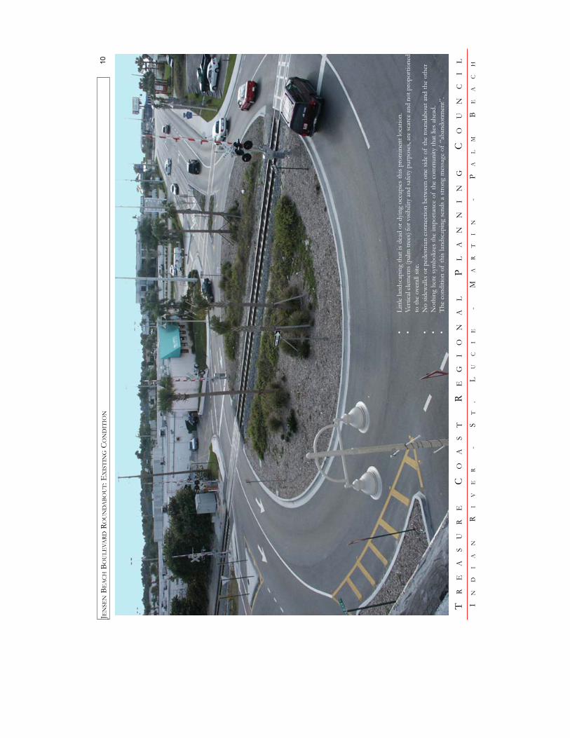
APPENDIX D RAILROAD CROSSINGS THROUGH ROUNDABOUTS

Sa
lt La
ke C
ity, U
T

Sa
lt La
ke C
ity, U
T
TR
EA
SU
RE
CO
AS
TR
EG
IO
NA
LP
LA
NN
IN
GC
OU
NC
IL
IN
DI
AN
RI
VE
R-
S
T.
LU
CI
E-
M
AR
TI
N-
P
AL
MB
EA
CH
JEN
SEN
BEAC
HBO
ULE
VARD
ROU
ND
ABO
UT:
EX
ISTI
NG
CON
DIT
ION
10
•Li
ttle
lands
capi
ng th
at is
dea
d or
dyi
ng o
ccup
ies t
his p
rom
inen
t loc
atio
n.•
Vert
ical
elem
ents
(palm
tree
s) fo
r visi
bilit
y and
safe
ty p
urpo
ses,
are s
carc
e and
not
pro
port
ione
dto
the
over
all si
te.
•N
o sid
ewalk
s or p
edes
trian
con
nect
ion
betw
een
one
side
ofth
e ro
unda
bout
and
the
othe
r•
Not
hing
her
e sy
mbo
lizes
the
impo
rtan
ce o
fth
e co
mm
unity
that
lies
ahe
ad.
•Th
e co
nditi
on o
fth
is lan
dsca
ping
send
s a st
rong
mes
sage
of
“aba
ndon
men
t”.
Downtown Development Authority/City of Fort Collins, CO Quiet Zone Study
Appendix
APPENDIX E FIELD DIAGNOSTIC REVIEW SUMMARIES

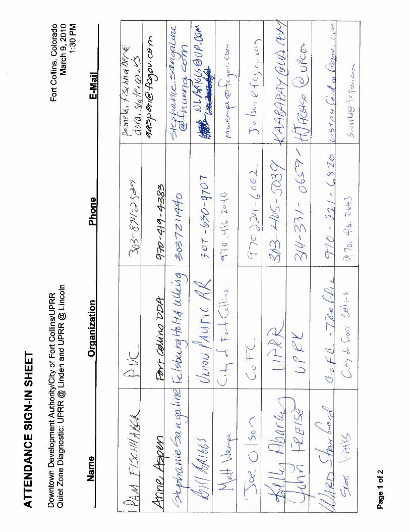
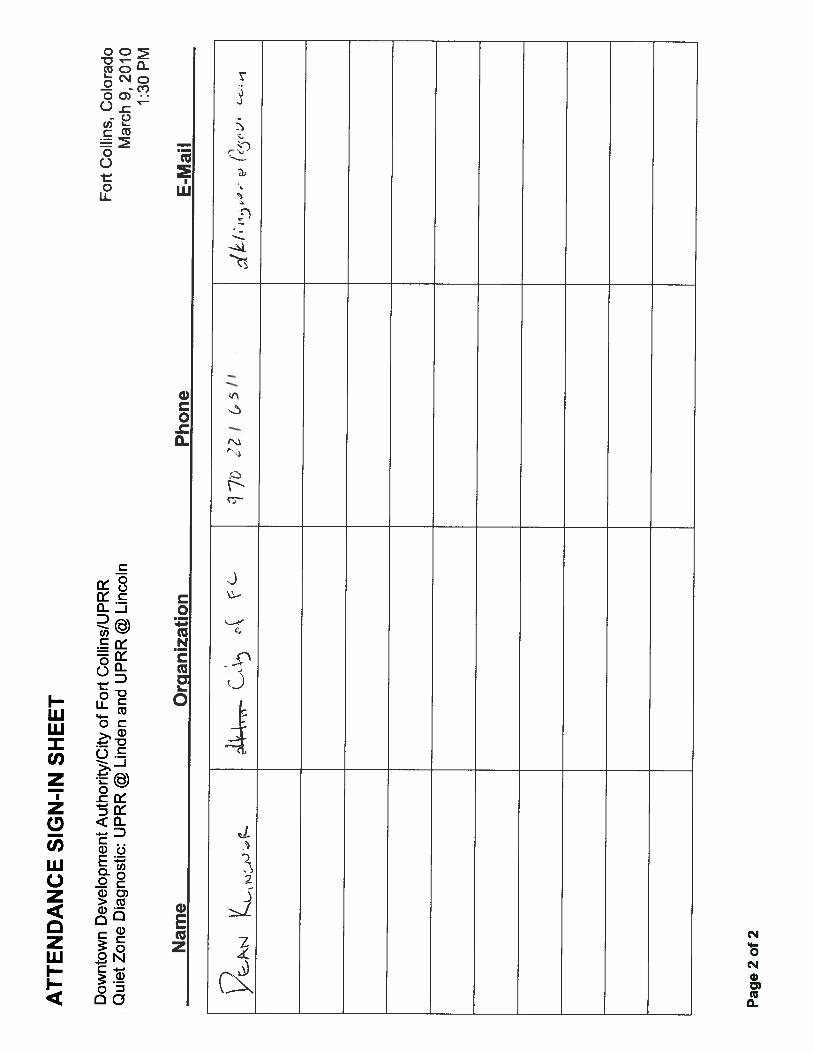
Downtown Development Authority/City of Fort Collins/Union Pacific Railroad Quiet Zone Field Diagnostic Review March 9, 2010 Lincoln Avenue-UPRR Crossing 1:30 PM Linden Street – UPRR Crossing ATTENDANCE See attached sign in sheets DIAGNOSTIC SUMMARY
The following summarizes the group’s discussion regarding existing railroad crossing features and possible railroad warning device installation for Quiet Zone establishment at each crossing. Lincoln Ave and Linden St -
1. Lincoln Ave. and Linden St. crossings are both currently equipped with HXP3 constant warning time circuitry.
2. UPRR indicated this circuitry may not support an upgrade to 4-quadrant gates or installation of wayside horns. It is likely the bungalow, gates and circuitry would need to be upgraded.
3. UPRR stated: a. recent installations Castle Rock ran $350k to $370k b. to budget $400k for each crossing c. the majority of the cost is for the bungalow and circuitry d. gate installation runs about $8000 (without maintenance), so it may be cost effective to
install the 4-quad gates. 4. UPRR will not do any additional work on these crossings following this Diagnostic Review
without receipt of a Preliminary Engineering (PE) Letter indicating the DDA/City will reimburse the UPRR for any design engineering or cost estimating. Initial costs run $5000 for circuitry design and $10,000 for design associated with Wayside Horn installation.
5. DDA indicated the timeline for Quiet Zone improvements is dependant upon funding. The study currently underway is funded, and our current efforts are to determine through Diagnostic Reviews with the agencies of jurisdiction what possible Quiet Zone improvements would be acceptable. The DDA and City are investigating funding options for implementation.
Lincoln Ave –
1. UPRR indicated the 12” lights are LED lights. The gates lights are incandescents. Linden St –
1. Linden Street corridor is being designed for street improvements. 2. The City would like to look at an alternative to remove the existing medians. PUC indicated
removal of the medians and mast-mounted flashers would reduce the level of safety warning. There would need to be some replacement installation for the median mast-mounted flashers if the medians are removed.
3. UPRR suggested cantilever lights over the street approaches may be an option. 4. The City stated they would like to pursue the utility work associated with the Linden Street
project later this year.

Downtown Development Authority/City of Fort Collins/Union Pacific Railroad Quiet Zone Field Diagnostic Review March 9, 2010 Lincoln Avenue-UPRR Crossing 1:30 PM Linden Street – UPRR Crossing Page 2
5. PUC encouraged the City to consider the potential future placement of elements for Quiet Zone compliance in the Linden Street project design so as to avoid the need for relocation or reconstruction of facilities at a later date. Sidewalks need to be routed around the back side of gates, with 5 foot of clear distance to allow space for the counterbalance of the gate. The possible placement of entrance and exit gates (as for a 4-quadrant installation) would cause the sidewalk to be detached for a longer length across the crossing to get past both gates, prior to being returned to the back of curb.
6. The City stated the sidewalks will be 15 feet wide, on both the north and south sides of the roadway. These are sidewalks only. Bike lanes will remain on the street.
7. It appears the concrete crossing material length is the full width of the Linden Street roadway easement. Therefore, sidewalks would be constructed leading up to either side of the existing crossing material.
8. PUC stated the existing medians appear to be narrower than current MUTCD standards. The medians, if to remain, would need to be widened to current MUTCD standards.
9. UPRR asked if the City would need any additional easement width across the UPRR tracks for the sidewalks. The City will not need any additional easement width. The sidewalks will be within the existing roadway easement.
10. UPRR stated they like to have 3 additional feet of concrete crossing material beyond a sidewalk. If this concrete crossing material extends beyond the City’s easement, the City does not need to obtain an easement for that crossing material.
11. The UPRR will forward a .pdf of their standard flasher pole location and acceptable distances to the DDA for their use.
12. PUC indicated the recently issued 2009 version of the MUTCD requires either stop signs or yield signs along with cross bucks. This version of the MUTCD will likely be adopted prior to construction of the Linden Street improvements. Design should consider requirements of the 2009 MUTCD.
DETERMINATION The group agreed that at both the Lincoln Avenue crossing and Linden Street crossing, the two Quiet Zone Supplemental Safety Measure (SSM) options remain viable. The two options are:
1. 4-quadrant gates 2. Wayside horns

Downtown Development Authority/City of Fort Collins/BNSF Railway Fort Collins, Colorado Fort Collins Quiet Zone Office Meeting & Field Diagnostic Review April 15, 2010 Traffic Operations Center Conference Room & Site Visits 8:00 AM Print Date: April 23, 2010 Revision Date: April 26, 2010 ATTENDANCE See attached sign in sheet HANDOUTS
1. Partial Draft Report (Crossing Existing Conditions, Concept Crossing Improvement options, Track Isolation Renderings, Roundabout information)
2. FRA Inventory Reports for each crossing 3. Michigan State Rail Crossing presentation on Retractable Bollards 4. Mason 2-Way Installation Exhibits (from PUC filing)
DIAGNOSTIC SUMMARY
Opening Discussion:
1. Self introductions were made
2. Handout material was identified for the group’s reference during discussions
3. Anne (DDA) and Matt (City) gave a brief overview of the limits of this Quiet Zone Study a. Current DDA boundary limits include the crossings identified to be reviewed as part
of this diagnostic, however Myrtle and Laurel are outside of the current DDA boundary
b. The Quiet Zone Study is funded. Funding has not yet been for the implementation of the Quiet Zone
c. The purpose of this diagnostic is to determine what options are viable for the crossings within this study, to assist the DDA and City in refining a concept level cost estimate for use in pursuing funding
4. Rick (FHU) provided a brief overview of the current testing of retractable bollards being conducted in Michigan. Retractable bollards are not currently accepted by the PUC as a traffic control device. Proposed use of retractable bollards for isolation of track associated with Quiet Zone establishment would require an application to the FRA, monitoring and reporting as an Alternative Safety Measure (ASM).
5. Steph (FHU) provided background specifically regarding the downtown corridor regarding the imminent conversion of Mason Street to 2-way operation and the planned installation of additional warning devices along the corridor. This 2-way scenario will be

Downtown Development Authority/City of Fort Collins/BNSF Railway Fort Collins, Colorado Fort Collins Quiet Zone Office Meeting & Field Diagnostic Review April 15, 2010 Traffic Operations Center Conference Room & Site Visits 8:00 AM Page 2 Revised April 26, 2010
an as-built condition when Quiet Zone treatments are implemented and should be kept in mind when reviewing the downtown crossings as part of this diagnostic review.
6. Andy (BNSF) stated that primary reasons for train horn blowing within established Quiet Zones is due to trespassing, presence of roadway workers, or train switching in the vicinity of a crossing. Howard (FRA) reiterated Andy’s comments, emphasizing that trespassing is a big issue.
7. The group discussed the need for track isolation between the cross streets through downtown Mason as a measure to discourage pedestrian/bike movements over the tracks between crossings. These movements cause locomotive engineers to sound the horn even in established Quiet Zones as a warning device for those crossing the tracks.
The initial crossing concepts included the placement of curb and gutter along the track envelope, and allowing removal of pavement and track rehabilitation to restore the standard open ballast condition. This, as a minimum treatment between cross streets, would effectively prevent vehicles from crossing to the opposite side of the tracks except at cross streets. The issue with only curb, gutter and the open ballast section is the possibility of pedestrian slip, trip or fall within the track envelope in an attempt to cross mid-block. This would be a liability to the City .
The group discussed other features, in addition to the curb, gutter and open ballast condition, that may discourage mid-block crossing, as follows: Treatment Option Pros Cons Fence along one side of the tracks between cross streets
1. Discourages mid block crossing by pedestrians and bikes
2. Combined with crossing treatments, blocks the entire corridor during presence of a train
1. Inhibits downtown circulation of pedestrians and bikes for retail businesses
2. Aesthetically unattractive 3. Divides the downtown area
Seat/planter walls along the outside of sidewalks and elimination of parking (i.e. between Laporte & Mountain – east side)
1. Pedestrians less likely to climb over seat/planter walls to cross streets mid-block
2. Effectively discourages pedestrians on the opposite side of the street from crossing mid-block as there is no sidewalk access except at cross streets
1. Lack of parking and inability to access businesses has detrimental economic effects on businesses within this type of treatment
2. Creates a “sterile” environment with more hard infrastructure
8. Andy (BNSF) stated the BNSF will oppose any applications for roundabouts at the
crossings through downtown Fort Collins. The group discussed the concern of traffic queuing back over the tracks and how this would be cleared. While there are existing roundabouts with railroad tracks through them in other states, no one in the group had

Downtown Development Authority/City of Fort Collins/BNSF Railway Fort Collins, Colorado Fort Collins Quiet Zone Office Meeting & Field Diagnostic Review April 15, 2010 Traffic Operations Center Conference Room & Site Visits 8:00 AM Page 3 Revised April 26, 2010
any information regarding how the roundabouts are working or if there have been any incidents
9. Generally with regard to pedestrian and bicycle movements, it is anticipated that upon conversion to 2-way operation, these movements may become more cumbersome for users to cross 2 directions of vehicle traffic as well as the freight rail tracks. It was suggested that the 2-way operation be monitored for a period of time to determine if this is the case, prior to finalizing recommendations for mid-block treatments to discourage this behavior
10. An FRA application for Quiet Zone establishment along Mason Street must address treatments at all of the public at-grade crossings. The FRA Final Rule does not address treatments between public at-grade crossings.
11. The PUC rule currently indicates that pedestrian crossings of a mainline track must be grade separated. Therefore if any crossings are proposed for closure along Mason Street the associated pedestrian sidewalks would also need to be closed or grade separated. The group questioned if the Commission would consider allowing closure of the roadway portion, and allowing the sidewalks to remain open, provided fencing was installed along one side of the tracks, and the sidewalk crossings treated with pedestrian scale warning devices. Pam (PUC) indicated she did not know how the Commission may respond to that request. Generally the only way to find out is to submit a PUC application with this scenario and see if it is accepted by the Commission.
12. The general recommendation of the PUC and FRA was to look at the 4-quadrant gate option at every crossing through downtown as this option would truly isolate the tracks while allowing thru movements along Mason and right-in-right-out movements to continue during train presence.
13. The group discussed the process of coordinating with the PUC and FRA. The PUC has
authority in Colorado over all railroad crossings for safety. The FRA has nationwide jurisdiction with regard to treatments for Quiet Zone establishment. There was question, given the unique nature of the Mason Street corridor downtown, as to whether a proposed treatment for Quiet Zone establishment would be in compliance with the Manual on Uniform Traffic Control Devices (MUTCD), and therefore acceptable to the PUC. Alternatively, proposed treatments could be applied for through the PUC process and potentially approved, but not viable for Quiet Zone establishment with the FRA. There is no clear resolution to this process issue. However, both agencies agreed that 4-quadrant gates immediately adjacent to the tracks at each crossing would satisfy both the PUC for safety and FRA for Quiet Zone establishment.
14. There was conversation among the group regarding the lack of precedent anywhere in
the country for a Quiet Zone being established in similar circumstances as the Mason Corridor. With this is mind, the group was continually encouraged to think outside the box to help determine what options could be available for establishing a Quiet Zone along the Mason corridor.

Downtown Development Authority/City of Fort Collins/BNSF Railway Fort Collins, Colorado Fort Collins Quiet Zone Office Meeting & Field Diagnostic Review April 15, 2010 Traffic Operations Center Conference Room & Site Visits 8:00 AM Page 4 Revised April 26, 2010
Crossing Review: The following summarizes the group’s discussion regarding railroad warning device options at the crossings:
Linden Street – a. Development north of Vine is residential b. Pam (PUC) indicated that the new 4th leg of the intersection to the north necessitates
some rotation of the existing railroad flashers to face north (they formerly faced northeasterly/northwesterly along the approaches on Vine prior to completion of the north roadway)
c. Wayside Horns and 4-Quadrant Gates are both still options for this crossing
College Avenue – a. Raised medians with approach gates are present at this crossing b. The north median needs to be extended to 100 feet from the gate arm c. The commercial business access on the southeast corner (currently Easycare Quick
Lube) needs to be relocated to 60 feet from the gate arm d. This crossing does have Constant Warning Time (CWT) circuitry e. The group discussed the detached pedestrian sidewalk west of College Avenue. The
2009 MUTCD requires separate treatment for detached pedestrian facilities 25 feet or more away from the roadway; Pam (PUC) indicated that the 2009 MUTCD has not been adopted by the Transportation Commission as of yet. Additionally, because the sidewalk configuration is existing and was completed prior to the 2009 MUTCD recommendations, the PUC would not likely require modifications.
f. Wayside horns could be considered as an option if the commercial access on the southeast quadrant cannot be relocated to 60 feet from the gate arm
Cherry Street – a. Has CWT circuitry b. The raised median with approach gate option will work if the alley on the southeast
quadrant can be closed or relocated c. The property east of the alley is slated for redevelopment. It may be possible as part
of that redevelopment to redefine the closest access at 60 feet from the gate arm, which is approximately at the location of the parking lot access east of the alley
Maple Street - a. None of the original options completely isolates the railroad tracks b. The group identified the 4-quadrant gate option as the favored option to isolate the
tracks c. Northbound and southbound left turns from Mason Street will be prohibited in the 2-
way operation d. Left turn movements from Maple onto Mason may conflict with gate base locations;
this will need to be reviewed e. Maple at Mason is does not have a traffic signal
Downtown Development Authority/City of Fort Collins/BNSF Railway Fort Collins, Colorado Fort Collins Quiet Zone Office Meeting & Field Diagnostic Review April 15, 2010 Traffic Operations Center Conference Room & Site Visits 8:00 AM Page 5 Revised April 26, 2010
f. Due to the curve of the mainline track to the east just north of Maple, an additional approach gate is recommended for the northbound lane of Mason just north of Maple to stop traffic prior to the mainline track crossing this lane
g. The median curbline along the west side of the mainline track should be extended north past the multi-family residential building access on the northwest quadrant of Mason and Maple. Additionally, the access should be right-in-right-out only to prohibit left turns out of the access that could conflict with train movements
Laporte Avenue – a. This crossing needs CWT circuitry b. This intersection has a wider pavement section on all four legs of the intersection
making it difficult to close completely with 4-quadrant gates c. Left turn movements are allowed in all directions at this intersection; gate bases may
be within the wheel track of left turn movements and will need to be reviewed d. This intersection has a traffic signal which will remain and be reconfigured for the 2-
way operation e. Consideration can be given to eliminating or dropping lanes at the intersection or
narrowing lanes through the intersection to create a crossing that can be completely closed by 4-quadrant gates
f. Placement of small curb islands within the intersection to potentially house additional gates would cause the elimination of left turn movements in nearly all directions; this is not desirable by the City
Mountain Avenue - a. The 4-quadrant gate option will close off this crossing completely b. Left turn movements are allowed in all directions at this intersection; gate bases may
be within the wheel track of left turn movements and will need to be reviewed c. There will be a dedicated left turn lane and a thru-right lane in the northbound and
southbound directions on Mason in the 2-way operation. d. This intersection has a traffic signal which will remain and be reconfigured for the 2-
way operation e. The 4-quadrant gate option would require space within the dedicated left turn lanes
for placement of the gate bases. This will push the dedicated left turn lanes out, as well as the thru-right lanes out.
f. The City may consider two options to this scenario: a. Prohibiting left turns from Mason Street in both directions to narrow the
laneage to one lane northbound and one lane southbound b. Obtaining the additional area to the outside of the street to provide for both
lanes at the intersection (the additional area may be obtained through elimination of parking, or acquisition of additional right-of-way)
Oak Street – a. Northbound and southbound left turns from Mason Street will be prohibited in the 2-
way operation b. This intersection has a traffic signal which will remain and be reconfigured for the 2-
way operation
Downtown Development Authority/City of Fort Collins/BNSF Railway Fort Collins, Colorado Fort Collins Quiet Zone Office Meeting & Field Diagnostic Review April 15, 2010 Traffic Operations Center Conference Room & Site Visits 8:00 AM Page 6 Revised April 26, 2010
c. The original preferred concept of closure at this crossing is no longer acceptable to the DDA or the City because they do not wish to lose the pedestrian crossings at this location (Oak Street east of Mason is a pedestrian-friendly area and closed off from College Avenue)
d. 4-quadrant gates would close this crossing completely e. Left turn movements from Oak onto Mason may conflict with gate base locations;
this will need to be reviewed f. An additional option to be considered includes creating a one-way east street on Oak
to the east of Mason and creating a one-way movement eastbound Oak to northbound Mason (westbound Oak to southbound Mason would not be allowed). This option will be generated as a possible concept at this crossing with the Quiet Zone treatment of one-way street with gates
Olive Street - a. The 4-quadrant gate option will close off this crossing completely b. Left turn movements are allowed in all directions at this intersection; gate bases may
be within the wheel track of left turn movements and will need to be reviewed c. There will be a dedicated left turn lane and a thru-right lane in the northbound and
southbound directions on Mason in the 2-way operation. d. This intersection has a traffic signal which will remain and be reconfigured for the 2-
way operation e. The 4-quadrant gate option would require space within the dedicated left turn lanes
for placement of the gate bases. This will push the dedicated left turn lanes out, as well as the thru-right lanes out.
f. The City may consider two options to this scenario: a. Prohibiting left turns from Mason Street in both directions to narrow the
laneage to one lane northbound and one lane southbound b. Obtaining the additional area to the outside of the street to provide for both
lanes at the intersection (the additional area may be obtained through elimination of parking, or acquisition of additional right-of-way)
Magnolia Street – a. Northbound and southbound left turns from Mason Street will be prohibited in the 2-
way operation b. This intersection does not have a traffic signal. It will remain a passive crossing in
the 2-way operation c. Magnolia is stop controlled; Mason is the free flow movement d. Cross traffic on Magnolia is relatively constant as this is one of the few east-west
connector streets across the Mason corridor e. 4-quadrant gates would close this crossing completely f. Left turn movements from Magnolia onto Mason may conflict with gate base
locations; this will need to be reviewed Mulberry Street – a. The 4-quadrant gate option will close off this crossing completely

Downtown Development Authority/City of Fort Collins/BNSF Railway Fort Collins, Colorado Fort Collins Quiet Zone Office Meeting & Field Diagnostic Review April 15, 2010 Traffic Operations Center Conference Room & Site Visits 8:00 AM Page 7 Revised April 26, 2010
b. Left turn movements are allowed in all directions at this intersection; gate bases may be within the wheel track of left turn movements and will need to be reviewed
c. There will be a dedicated left turn lane and a thru-right lane in the northbound and southbound directions on Mason in the 2-way operation.
d. This intersection has a traffic signal which will remain and be reconfigured for the 2-way operation
e. The 4-quadrant gate option would require space within the dedicated left turn lanes for placement of the gate bases. This will push the dedicated left turn lanes out, as well as the thru-right lanes out.
f. The City may consider two options to this scenario: a. Prohibiting left turns from Mason Street in both directions to narrow the
laneage to one lane northbound and one lane southbound b. Obtaining the additional area to the outside of the street to provide for both
lanes at the intersection (the additional area may be obtained through elimination of parking, or acquisition of additional right-of-way)
Myrtle Street – Note: Myrtle Street was not reviewed in the field by the group; comments are provided for information only based on findings at other similar crossings a. Northbound and southbound left turns from Mason Street will be prohibited in the 2-
way operation b. This intersection does not have a traffic signal. It will remain a passive crossing in
the 2-way operation c. Myrtle is stop controlled; Mason is the free flow movement d. The original preferred concept of closure at this crossing is no longer acceptable to
the DDA or the City because they do not wish to lose the pedestrian crossings at this location
e. 4-quadrant gates would close this crossing completely f. Left turn movements from Myrtle onto Mason may conflict with gate base locations;
this will need to be reviewed Laurel Street - Note: Laurel Street was not reviewed in the field by the group; comments are provided for information only based on findings at other similar crossings a. The 4-quadrant gate option will close off this crossing completely b. Left turn movements are allowed in all directions at this intersection; gate bases may
be within the wheel track of left turn movements and will need to be reviewed c. This intersection has a traffic signal which will remain and be reconfigured for the 2-
way operation d. The 4-quadrant gate option would require space within the northbound and
southbound thru lanes on Mason for placement of the gate bases. This will push the thru lanes out, and may require additional right-of-way

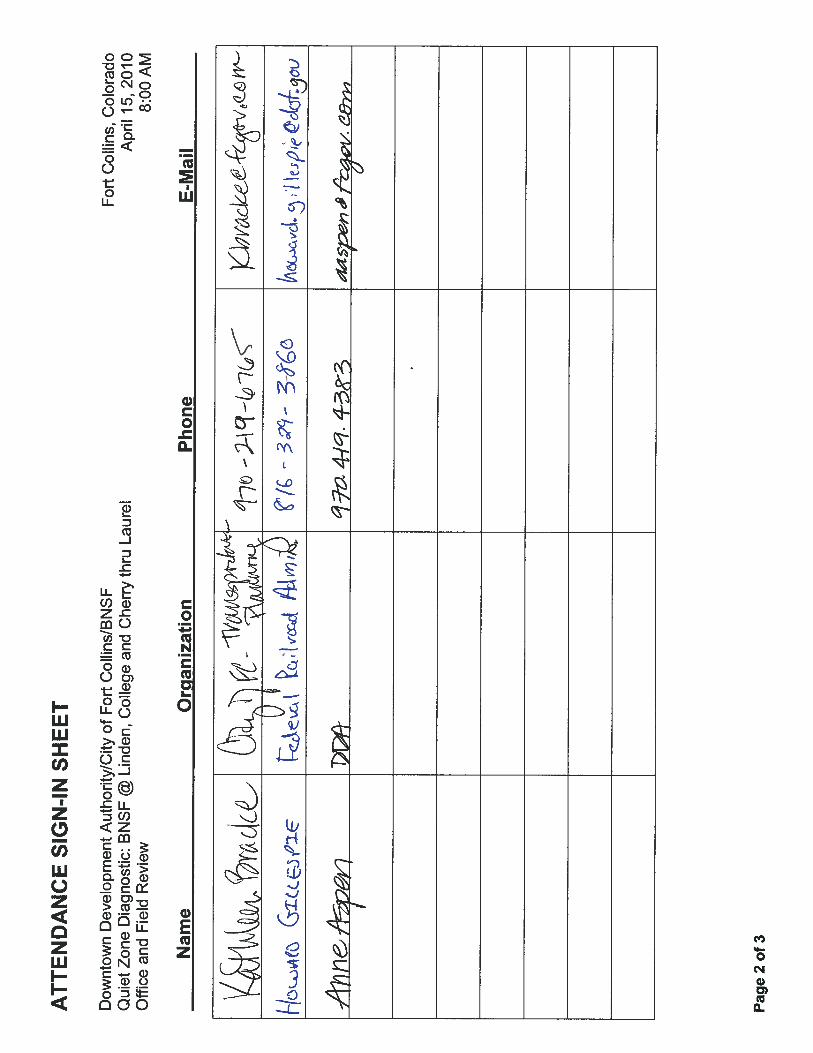

Downtown Development Authority/City of Fort Collins, CO Quiet Zone Study
Appendix
APPENDIX F MASON 2-WAY CONVERSION EXHIBITS
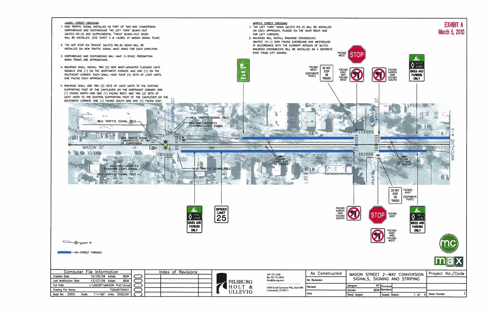
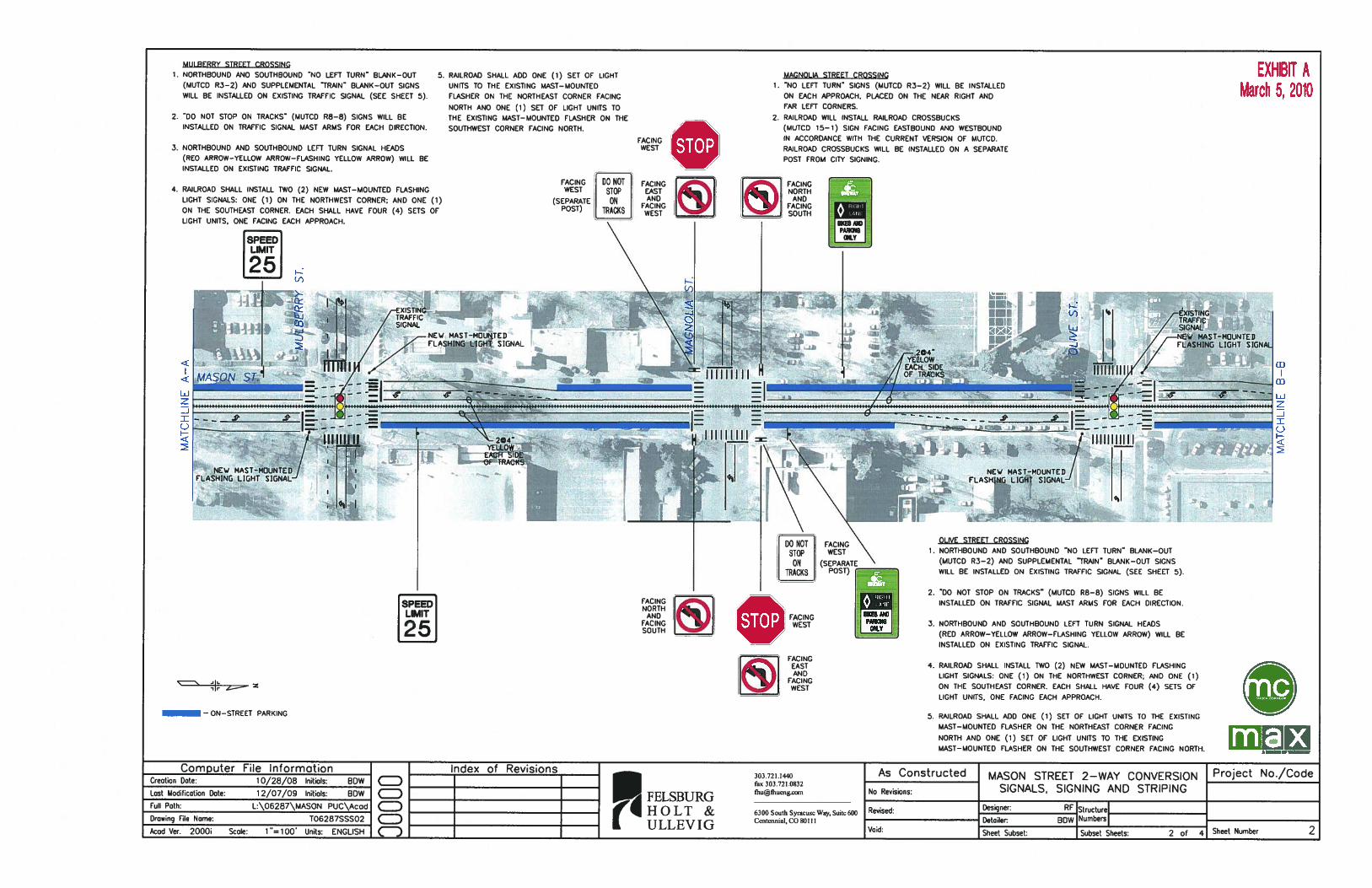


Recommended