UWM CAMPUS MASTER PLAN
NOVEMBER 2008 SUSTAINABILITY ASSESSMENT SECTION 2— 1
2.1 ASSESSMENT OF EXISTING HYDROLOGY AND STORM WATER
MANAGEMENT SYSTEMS
Impervious Area
Figure 2.1 shows the Kenwood Campus drainage divide. Storm water from
the north half of the campus discharges westward to a combined sewer in E.
Edgewood Avenue, which overflows to the Milwaukee River. Storm water
from the south half of the campus discharges west and south, to a combined
sewer in E. Park Place, which overflows to the Milwaukee River.
Approximately 62 acres of the campus drain to the north and 37 acres drain
to the south. The campus contains approximately 57 acres of impervious
surface, which is about 57 percent of the total area. There are 30 acres of
impervious surface in the northern drainage area (48 percent), and 27 acres
of impervious surface in the southern drainage area (73 percent). Downer’s
Woods are a large portion of the pervious area in the northern drainage area
Soil Conditions
General: The primary sources for soils data are the NRCS (formerly SCS)
soil surveys and actual soil boring logs from boring taken for specific
projects. The NRCS’s Soil Survey of Milwaukee and Waukesha Counties1
does not show specific soil types for the Kenwood Campus or the four
remote sites, as these locations are all within urbanized areas that have
previously been subjected to significant disturbance. Data from soil borings
for projects within the Kenwood Campus and at the remote sites can also be
used to determine the hydrological characteristics of the soils.
The NRCS has a hydrological classification system for soils that rates the
infiltration capacity of the soil2. Soils are classified as hydrological soil
classifications A, B, C or D, with A being the most permeable, and D being
the least. Group A soils are primarily composed of sands and gravels, while
Group D soils are primarily comprised of silts and clays. The NRCS’s
hydrological analysis methodology3 uses runoff curve numbers (RCN) to
compute the amount of runoff from various land cover types, and has
assigned the RCN’s based on the cover type and soil group. Land use types
within Group A soil areas have lower RCN’s than the same land use types
within Group B, C, or D areas, with Group D areas having the highest
RCN’s. Hydrological soil classifications have no impact on the RCN for
impervious areas.
Kenwood Campus: The NRCS Soil Survey does not show a soil type for the
Kenwood Campus area. This indicates that there has been significant soil
disturbance within an urbanized area. The NRCS does not assign a
hydrological soil classification to this type of soil.
1 U.S. Department of Agriculture, Natural Resources Conservation Service,
“Soil Survey Geographic (SSURGO) database for Milwaukee and
Waukesha Counties”, February 2004 2 Mockus, Victor et al., U.S. Department of Agriculture, “National
Engineering Handbook, Part 630, Chapter 7, Hydrologic Soil Groups”, May
2007 3 Cronshey, Roger et al., U.S. Department of Agriculture, “Urban
Hydrology for Small Watersheds, Technical Release 55”, June 1986

66
4
666
66
8
662660
674
67
2
658
670
676
68
0
68
4
682
678
65
6
65
4
68
6
652650
6 48
646
688
644
692
642
69
4
69
0
640
69
6
63 6638
69
8
70 0
66 4
662
664
698
68
8
67
2
6
74
6 70
636
67
2
67
8
6706
7667
4
67
6
662
674
638
68
6
6 9 6
690
68
8
67
2
672
66
4
69
2
67
0
6 82
698
66
4
6 6 0
692
682
6 78
692
678
6 98
6
74
638
69 6
666
682
6 94
66
6
68
8
6 88
686
6 62
666
66
8
69
0
6 90
678
682
6 7 6
66
4
670
68
8
670
682
660
682
69
8
64
0
646
684
690
69
4
69
0
69
0
6 62
66
8
66
8
67
0
6886
9
0
6 7
2
6 80
6 44
68
8
68
8
Campus Master Plan
November 2008
Figure 2.1
DrainageBoundary
I
North BasinDrains to EdgewoodCombined SewerOutfall to the Milwaukee River
Kenwood Blvd
Hartford Ave
Edgewood Ave
Ma
ryla
nd
A
ve
Do
wn
er
A
ve
South BasinDrains to ParkPlace CombinedSewer Outfallto The Milwaukee River
�
�
0 300100 200 Feet
Legend
Drainage Boundary
UWM CAMPUS MASTER PLAN
NOVEMBER 2008 SUSTAINABILITY ASSESSMENT SECTION 2— 2
The University prepared a report entitled “UWM as a Zero – Discharge Zone:
A Storm Water Master Plan for the UWM Campus”, dated May 5, 20064.
Chapter 3 of the Report, entitled “Runoff Modeling” begins with an M.S.
Engineering Thesis by Elizabeth Locke5 which states that the Kenwood
Campus has Group C soils, described as clay loams, soils low in organic
content, and soils usually high in clay.
Soil borings within the Kenwood Campus, obtained from the UWM Geologic
Sciences Department, show that the main soil constituent is clay, which
supports the assumption of Group C soils.
Kenilworth Building: The NRCS Soil Survey does not show a soil type for
the Kenilworth site. This indicates that there has been significant soil
disturbance within an urbanized area. The NRCS does not assign a
hydrological soil classification to this type of soil.
Hydrological analysis for the nearby Park Lafayette Condominium
Development assumed Group C soils for that site. Soil borings at the Park
Lafayette site show the main soil constituent is clay6.
Plankinton Building: The NRCS Soil Survey does not show a soil type for
the Plankinton site. This indicates that there has been significant soil
disturbance within an urbanized area. The NRCS does not assign a
hydrological soil classification to this type of soil.
The Plankinton site is located very close to the Milwaukee River, and has a
pile-supported foundation. This suggests soils with a high organic content,
and a high groundwater table.
Soil borings at and near the Plankinton site, including borings taken for the
Milwaukee Metropolitan Sewerage District’s (MMSD) Water Pollution
Abatement Program (WPAP), show substantial fill and clay7.
Group C soils would be assumed for a hydrologic analysis of the Plankinton
site.
Great Lakes Research Facility: The NRCS Soil Survey does not show a soil
type for the Great Lakes Research Facility site. This indicates that there has
been significant soil disturbance within an urbanized area. The NRCS does
not assign a hydrological soil classification to this type of soil.
4 Wasley, James et al., “UWM as a Zero-Discharge Zone, A stormwater
masterplan for the UWM Campus”, May 2006 5 Locke, Elizabeth, “Thesis Document - Runoff Modeling and Stormwater
Reduction Practices Study”, December 2005 6 Wisconsin Testing Laboratories, LLC, “Geotechnical Investigation –
Proposed Park Lafayette, E. Lafayette and N. Prospect Avenue, Milwaukee
Wisconsin”, November 2005 7 Contract Documents – Milwaukee Metropolitan Sewerage District, North
Shore 9/10 Collector Systems Volume III, Geotechnical Report”, January
1988

UWM CAMPUS MASTER PLAN
NOVEMBER 2008 SUSTAINABILITY ASSESSMENT SECTION 2— 3
The Great Lakes Research Facility site is located on the estuary of the
Kinnickinnic River, adjacent to the Greenfield Slip. Soils with a high organic
content and a high groundwater table would be expected at this site.
Soil borings at or near the Great Lakes Research Facility site, including
borings taken for the MMSD’s WPAP show substantial fill and clay8.
Group C soils would be assumed for a hydrologic analysis of the Great
Lakes Research Facility site.
University Services Site: The NRCS Soil Survey does not show a soil type
for the University Services area. This indicates that there has been
significant soil disturbance within an urbanized area. The NRCS does not
assign a hydrological soil classification to this type of soil.
Group C soils would be assumed for a hydrologic analysis of the University
Services site.
Storm Water Management
General: Storm Water Management is necessitated by development within
the natural environment that increases the rate and volume of storm water
discharge and contributes pollutants to the runoff. It is comprised of three
components: conveyance of runoff; control of runoff quantity; and removal
of pollutants from the runoff. Storm water conveyance is accomplished by
means of overland flow, pipes, and open channels. Storm water quantity
control is accomplished by temporary storage, to reduce the peak discharge
rate and prolong the duration of the discharge. Storm water quality control
involves a variety of measures to prevent the entry of pollutants, picked up
by the storm water during the conveyance process, from entering
watercourses.
Kenwood Campus: The Milwaukee Metropolitan Sewerage District
partnered with James Wasley and an interdisciplinary team at the University
of Wisconsin-Milwaukee on two projects: A study aimed at demonstrating
the potential for UWM’s urban campus to utilize best management practices
to become a stormwater friendly landscape, and the design of a
demonstration project that fits the framework of the stormwater study.
The study report, titled “UWM as a Zero-Discharge Zone”4 outlines the
masterplanning project, which created an inventory of design opportunities
to transform the UWM campus into a testing site for urban stormwater best
management practices. The ultimate goal is achieving a 100-year zero-
discharge condition for the campus as a whole. The study has catalogued
the potentials on campus for green roof retrofits, downspout disconnections,
and the redesign of both pedestrian and vehicular hardscaped areas. The
8 Contract Documents – Milwaukee Metropolitan Sewerage District,
Crosstown 8 Collector Systems Volume II, Specifications, Plans,
Geotechnical Report”, October 1986
Figure 2.2 UWM Kenwood Campus
(Source: www.uwm.edu/about-uwm)

UWM CAMPUS MASTER PLAN
NOVEMBER 2008 SUSTAINABILITY ASSESSMENT SECTION 2— 4
study also includes design opportunities related to ‘daylighting’ stormwater
once it has entered the campus storm sewer system.
The design project, “The Pavilion Gateway Demonstration Project”9, details
the redesign of four acres of the UWM campus to meet this same ‘zero-
discharge’ standard. The Pavilion Gateway Project proposes the creation of
five gardens and other interconnecting landscape features, totaling
approximately 13,000 square feet of enhanced landscaping. Components of
the project include 32,000 square feet of internally drained roofs captured
and day lit to create sculptural water features; 39,000 square feet of
externally drained roofs captured through 31 sculptural downspout
disconnections on 7 different buildings; the elimination of 2-½ parking lots
and 11,000 square feet of asphalt with a net loss of only 5 parking spaces;
20,000 square feet of pervious paving of various types installed for
demonstration purposes; and the creation of a scientific research garden
capable of replicating radically different soils profiles native to Wisconsin, as
well as of the infrastructure necessary to treat the entire demonstration site
as an ongoing research project and outdoor classroom.
Figure 6.5 shows the storm water conveyance system that serves the
Kenwood Campus. Figure 2.1 shows the topography of the Kenwood
Campus area, and the drainage divide, with approximately 62 acres draining
to the north, and approximately 37 acres draining to the south. Both of the
major drainage areas discharge to the west, eventually reaching the
Milwaukee River via the City of Milwaukee’s combined sewer system. Note
that a significant portion of this storm water enters the MMSD’s Deep Tunnel
System and is then conveyed to the MMSD’s treatment plants for treatment
prior to discharge to Lake Michigan. There are occasions, during extreme
precipitation events, that the storm water is bypassed around the Deep
Tunnel System and is discharged, combined with wastewater, directly to the
river. A reduction in the rate and volume of storm water discharge would
reduce the frequency of these “overflow” events. This is the basis of UWM’s
goal to become a “zero-discharge zone”.
Kenilworth Building: The Kenilworth building, located at 1925 East
Kenilworth Place, is approximately 34,000 square feet. The Kenilworth
Building provides storage and research facilities for the School of Fine Arts
and also contains a UWM Parking and Transit office and retail tenants. The
site, as it is currently developed, is served by City of Milwaukee combined
sewers in N. Prospect Avenue, E. Kenilworth Place, and N. Farwell Avenue.
It does not contain any storm water BMP’s.
Plankinton Building: The Plankinton Building, located at 161 West
Wisconsin Avenue, is home to the School of Continuing Education. The
School occupies the top two floors of the historic building overlooking the
Grand Avenue Mall. The remodeled 100,000 square-foot facility contains
multimedia classrooms, meeting rooms, computer labs, dining facilities and
offices. The Plankinton Building is served by City of Milwaukee combined
sewers in W. Wisconsin Avenue, N. Plankinton Avenue and N. 2nd Street.
9 Wasley, James et al., “The Pavilion Gateway Demonstration Project”,
May 2006

UWM CAMPUS MASTER PLAN
NOVEMBER 2008 SUSTAINABILITY ASSESSMENT SECTION 2— 5
There is a separate storm sewer in Wisconsin Avenue, owned by the
MMSD. These mains convey wastewater and storm water discharge from
the building, and collect storm water from the site and adjacent right-of-way.
Great Lakes Research Facility: The Great Lakes Research Facility, which
houses the Great Lakes Water Research Institute, is located at 600 East
Greenfield Avenue, and is approximately 98,000 square feet. It is the
primary home of the UWM Center for Great Lakes Studies, and also houses
a federally funded biomedical and environmental research laboratory and
the University of Wisconsin Sea Grant Institute. The Water Institute teamed
up with the Milwaukee Metropolitan Sewerage District (MMSD) in 2003 to
test a method of water pollution control. A portion of the roof was converted
to a 10,000 square foot green roof. There is a combined sewer outfall in
Greenfield Avenue, owned by the MMSD, that handles storm water
discharge from the building, the site, and the adjacent right-of-way.
University Services Site: The University Services building, located at 115 by
other tenants. The UWM building portions cover approximately 150,000
square feet. The site is served by City of Glendale separate storm sewers in
N. Lydell Avenue, E. Reindl Way, N. Hubbard Street and E. Fiebrantz
Avenue. These mains convey storm water discharge from the building, and
collect storm water from the site and adjacent right-of-way. As it is currently
developed, the site does not contain storm water BMP’s.
Storm Water Regulations
Storm water management within the master plan area is regulated by the
local municipalities, the MMSD, the Wisconsin Department of Natural
Resources (WDNR), and the United States Environmental Protection
Agency (USEPA), and the U.S. Army Corps of Engineers (CORPS).
Regulatory requirements from the Federal government, such as the National
Pollutant Discharge Elimination System (NPDES) are applied through State
and local programs. Impacts to waterways and wetlands are also regulated
by all of the above listed entities. The Kenwood Campus and the
Kenilworth, Plankinton, and Great Lakes sites are located within the City of
Milwaukee, and are subject to Milwaukee’s Ordinance 120 requirements.
The University Services site is located in the City of Glendale, and is subject
to Glendale’s Storm Water Management Ordinance. Following is a list of the
applicable regulations:
NR 216 (Comm 60) Storm Water Discharge Permits
NR 151 (Comm 60, Comm 82, Comm 85) Runoff Management
NR 116 – Wisconsin’s Floodplain Management Program
Chapter 30 – Navigable Waters, Harbors and Navigation
City of Milwaukee Ordinance - Chapter 120
City of Glendale Ordinance - Title 6, Chapter 5
Milwaukee Metropolitan Sewerage District – Chapter 13
Section 404 of the Federal Clean Water Act
NR 216 (Comm 60) Storm Water Discharge Permits
NR 216 of the Wisconsin Administrative Code covers three types of storm
water discharge permits: Municipal, Industrial and Construction Site. UWM
Figure 2.3 GLRF Green Roof
(Source: glwi.uwm.edu /resarch/
genomics/ecoli/greenroof)
Figure 2.4 GLRF Green Roof
(Source: glwi.uwm.edu /resarch/
genomics/ecoli/greenroof)

UWM CAMPUS MASTER PLAN
NOVEMBER 2008 SUSTAINABILITY ASSESSMENT SECTION 2— 6
must meet the Construction Site Storm Water Discharge Permit
requirements.
The cities of Milwaukee and Glendale have initiated regulations and actions
that will meet the Municipal Storm Water Discharge Permit. The cities have
adopted MMSD Chapter 13 regulations, and must enforce NR 151 post-
construction storm water performance standards.
The Construction Site Storm Water Discharge Permit is applicable to UWM.
Subchapter III of NR 216 describes the permit requirements that apply to
construction sites that are one or more acres of disturbed land. To obtain a
Construction Site Erosion Control and Storm Water Discharge Permit, the
landowner must:
• Develop a Storm Water Pollution Prevention and Erosion Control
Plan describing the best management practices that will be used
on-site for erosion control. The Wisconsin Construction Site Best
Management Practice Handbook was written by the Department to
assist landowners and contractors in developing a Construction
Site Erosion Control Plan. Conformance with the handbook is
required under NR 216.46(1).
• Submit a Construction Site Notice of Intent form to the WDNR of
the Department of Commerce before construction begins.
• Implement best management practices, as described in the Storm
Water Pollution Prevention and Erosion Control Plan, to help
control erosion and prevent contamination of storm water.
• Conduct weekly on-site inspections through the duration of the
project.
Municipalities are authorized to provide technical reviews and administration
of the construction site permit. Subchapter III of NR 151 reiterates the
construction site requirement of NR 216. A permit is not required for routine
maintenance, if the site is less than 1 acre.
NR 151 (Comm 60, Comm 82, Comm 85) – Runoff Management
Chapter NR 151, Runoff Management, of the Wisconsin Administrative Code
provides runoff pollution performance standards and practices to achieve
water quality standards. Subchapter III focuses on non-agricultural
performance standards for development and redevelopment. Construction
sites of one or more acres require an erosion control plan using BMPs.
The construction site erosion control plan should show BMPs that, by
design, achieve, to the maximum extent practicable, a reduction of 80
percent of the sediment load carried in runoff, on an average annual basis,
as compared with no sediment or erosion controls, until the construction site
has undergone final stabilization. Generally, current erosion control plans
will meet this requirement.

UWM CAMPUS MASTER PLAN
NOVEMBER 2008 SUSTAINABILITY ASSESSMENT SECTION 2— 7
Maximum Extent Practicable (MEP) is the degree to which BMP’s are
required to perform, and considers available technology, cost, safety,
welfare, endangered resources, historic resources and geographical
resources. MEP allows “flexibility” in meeting standards.
Post-construction performance standards for new development and
redevelopment are provided in NR 151.12 and are applicable to all land
disturbances that are one or more acres. Post-construction performance
standards apply to control of total suspended solids, peak runoff discharge
rates, infiltration, protecting certain natural resources, and controlling fueling
and vehicle maintaining maintenance areas.
BMPs shall be designed, installed and maintained to control total suspended
solids carried in runoff from the post−construction site. BMPs for new
development, by design, should reduce to the maximum extent practicable,
the total suspended solids load by 80 percent, based on an average annual
rainfall, as compared to no runoff management controls. BMPs for
redevelopment, should be designed to reduce, to the maximum extent
practicable, the total suspended solids load by 40 percent, based on an
average annual rainfall, as compared to no runoff management controls
BMPs by design shall be employed to maintain or reduce the peak runoff
discharge rates, to the maximum extent practicable, as compared to
predevelopment conditions for the 2−year, 24−hour design storm applicable
to the post−construction site. Redevelopment sites are exempt from peak
runoff reduction.
Infiltration of storm water may be required. An infiltration facility should
provide 60 percent of the pre-development infiltration, for non-residential
areas, for the 2-year, 24-hour storm, using no more than 2 percent of the site
area. This administrative rule has numerous exceptions and prohibitions
related to redevelopment areas.
Lakes, streams, and wetlands are “protected areas” and require buffers for
certain uses. The buffers range from 10 to 50 feet, with many variables.
Fueling and maintenance areas have special requirements in NR 151.
NR 116 – Wisconsin’s Floodplain Management Program
Municipalities are required by State Statute 87.30 (1) to adopt reasonable
and effective floodplain zoning ordinances within their respective
jurisdictions to regulate all floodplains where serious flood damage may
occur. The purpose of these rules is to provide a uniform basis for the
preparation and implementation of sound floodplain regulations.
The 100-year rainfall event produces a water surface that, when mapped
with topography, generates a floodplain that is regulated by municipalities for
navigable waters relating to NR 116. This Administrative Code prohibits a
development from increasing the water surface of a floodplain by more than
0.01 feet, without providing compensatory floodplain volume.

UWM CAMPUS MASTER PLAN
NOVEMBER 2008 SUSTAINABILITY ASSESSMENT SECTION 2— 8
Chapter 30 – Navigable Waters, Harbors and Navigation
Chapter 30 of the Wisconsin statutes regulates navigable waters. Chapter
30 was changed in 2004 to reduce the frequency of permits. This change
will allow grading more than 75 feet from a navigable waterway without
obtaining a Chapter 30 permit from WDNR.
City of Milwaukee Ordinance - Chapter 120
The City of Milwaukee’s stormwater requirements are found in Chapter 120
of the City’s Code of Ordinances. If the development or redevelopment
causes an increase of 0.5 acres or more of impervious area, the release rate
and requirements are governed by MMSD’s Chapter 13 rules for water
quantity control. If the development or redevelopment disturbs more than an
acre of land and does not cause an increase of 0.5 acres or more of
impervious area, the peak runoff flow rates under post-development
conditions shall be at least 10% less than the peak runoff rates under pre-
development conditions. The City has adopted NR151 requirements for
water quality, without amendment.
City of Glendale Ordinance - Title 6, Chapter 5
The City of Glendale has adopted MMSD’s Chapter 13 rules for water
quantity control with one amendment. The 100-year post-development peak
runoff discharge shall not exceed the more restrictive of either 0.5 cfs per
acre or exceed the maximum hydraulic capacity of existing downstream
conveyance, drainage, or storage facilities. The City has adopted NR151
requirements for water quality, without amendment.
Milwaukee Metropolitan Sewerage District – Chapter 13
The MMSD’s Chapter 13 rules define storm water management
requirements for the entire MMSD service area, which includes the Cities of
Milwaukee and Glendale. The rules apply to proposed developments which
will result in a net increase in impervious surfaces of 0.5 acres or greater.
The Chapter 13 rules allow two methods for determination of the volume of
detention required. Under the Allowable Release Rate Method, the
detention volume is computed based on an allowable discharge from the
developed site of 0.5 cfs per acre for the 100-year storm event and 0.15 cfs
per acre for the 2-year storm event. Under the Volumetric Method, the
detention volume is computed based on the volume of runoff in the outflow
hydrograph for developed conditions being equal to or less than the volume
of runoff in the outflow hydrograph for existing conditions, during the critical
duration on the affected watercourse.
Section 404 of the Federal Clean Water Act
The Corps of Engineers (COE) regulates discharges to “Waters of the U.S.”,
including filling and excavation of wetlands. Section 404 applies to most
wetlands in the State connected to federal jurisdictional navigable
waterways. All COE regulated activities under Section 404 must comply
with the water quality certification of Chapter NR 299 of the Wisconsin
Administrative Code. Wetlands not governed by Section 404 are governed
by WDNR via water quality standards for surface waters in Chapter NR 102
and Chapter NR 299 of the Wisconsin Administrative Code. Land
UWM CAMPUS MASTER PLAN
NOVEMBER 2008 SUSTAINABILITY ASSESSMENT SECTION 2— 9
disturbances within a wetland boundary require a NR 103 Water Quality
Certification to be issued by the WDNR.
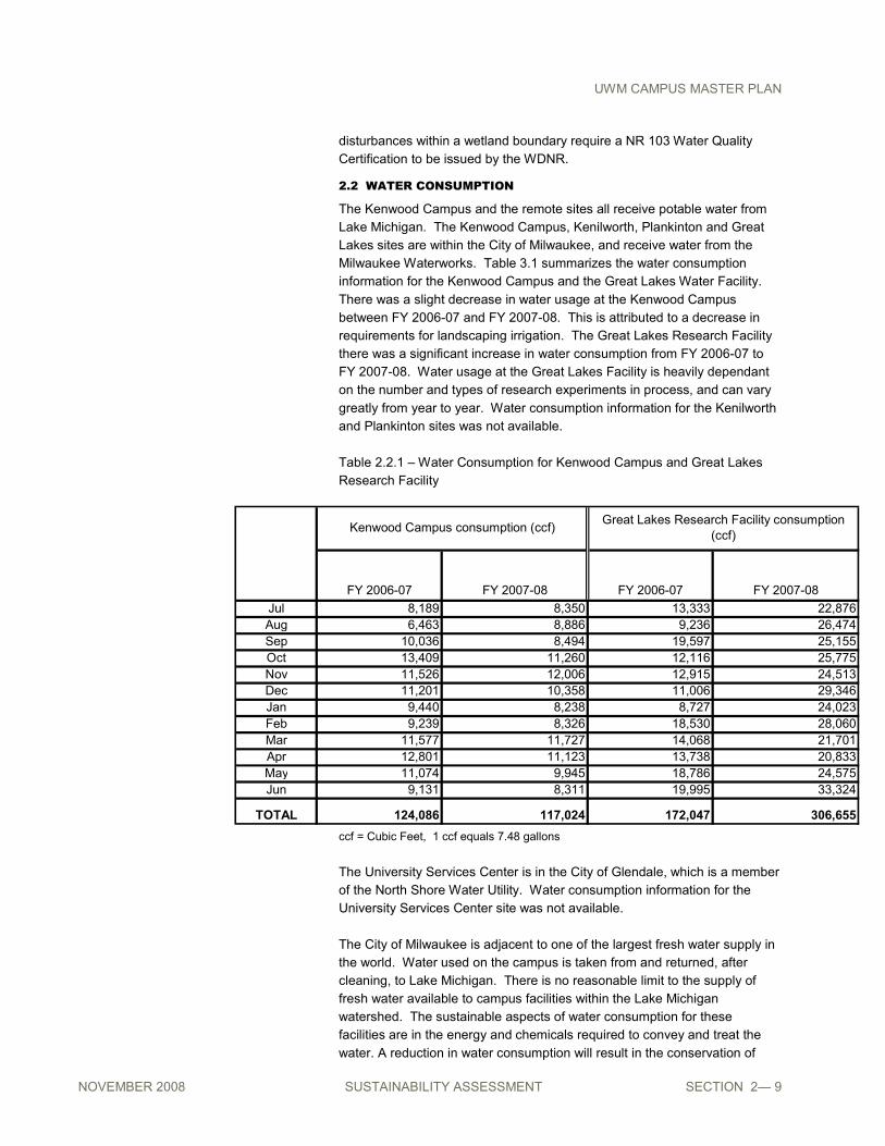
2.2 WATER CONSUMPTION
The Kenwood Campus and the remote sites all receive potable water from
Lake Michigan. The Kenwood Campus, Kenilworth, Plankinton and Great
Lakes sites are within the City of Milwaukee, and receive water from the
Milwaukee Waterworks. Table 3.1 summarizes the water consumption
information for the Kenwood Campus and the Great Lakes Water Facility.
There was a slight decrease in water usage at the Kenwood Campus
between FY 2006-07 and FY 2007-08. This is attributed to a decrease in
requirements for landscaping irrigation. The Great Lakes Research Facility
there was a significant increase in water consumption from FY 2006-07 to
FY 2007-08. Water usage at the Great Lakes Facility is heavily dependant
on the number and types of research experiments in process, and can vary
greatly from year to year. Water consumption information for the Kenilworth
and Plankinton sites was not available.
Table 2.2.1 – Water Consumption for Kenwood Campus and Great Lakes
Research Facility
FY 2006-07 FY 2007-08 FY 2006-07 FY 2007-08
Jul 8,189 8,350 13,333 22,876
Aug 6,463 8,886 9,236 26,474
Sep 10,036 8,494 19,597 25,155
Oct 13,409 11,260 12,116 25,775
Nov 11,526 12,006 12,915 24,513
Dec 11,201 10,358 11,006 29,346
Jan 9,440 8,238 8,727 24,023
Feb 9,239 8,326 18,530 28,060
Mar 11,577 11,727 14,068 21,701
Apr 12,801 11,123 13,738 20,833
May 11,074 9,945 18,786 24,575
Jun 9,131 8,311 19,995 33,324
TOTAL 124,086 117,024 172,047 306,655
Kenwood Campus consumption (ccf)Great Lakes Research Facility consumption
(ccf)
ccf = Cubic Feet, 1 ccf equals 7.48 gallons
The University Services Center is in the City of Glendale, which is a member
of the North Shore Water Utility. Water consumption information for the
University Services Center site was not available.
The City of Milwaukee is adjacent to one of the largest fresh water supply in
the world. Water used on the campus is taken from and returned, after
cleaning, to Lake Michigan. There is no reasonable limit to the supply of
fresh water available to campus facilities within the Lake Michigan
watershed. The sustainable aspects of water consumption for these
facilities are in the energy and chemicals required to convey and treat the
water. A reduction in water consumption will result in the conservation of

UWM CAMPUS MASTER PLAN
NOVEMBER 2008 SUSTAINABILITY ASSESSMENT SECTION 2— 10
energy and chemicals; and the materials and energy required to make those
chemicals. Expending more limited resources and energy to avoid using
Lake Michigan water in favor of other sources such as storm water and
groundwater does not appear to be an appropriate sustainable strategy.
The reduction of water consumption also reduces the amount of wastewater
produced, which, combined with a reduction in storm water discharge to the
combined sewer system will contribute to a reduction in sewer overflows that
discharge pollutants into the rivers and ultimately, Lake Michigan. The
University's Storm Water Management Plan recognizes this value, with its
"Zero Discharge Approach" for storm water.
2.3 KENWOOD CAMPUS ENERGY, WATER, AND EMISSIONS
Energy and Emissions
In order to begin to estimate energy consumption and campus greenhouse
gas emissions for the Kenwood campus, a preliminary inventory was
conducted. The inventory used the Clean Air Cool Planet Campus Carbon
Calculator to consider electricity and natural gas use in calendar year 2007.
The calculations factored in UWM-specific variables including local
temperature, campus population (considered to include full time enrollment
of students, faculty, staff), regional fuel mix, and total building space. Many
other factors contribute to Kenwood campus' complete energy and
emissions, such as transportation (university fleet, commuting
students/faculty/staff), waste, and water; however, this investigation focuses
on electricity and gas in the context of campus population and square
footage of campus buildings. Water consumption is addressed separately
from energy.
In the 2007 calendar year, it was reported that the Kenwood campus
consumed 528,381 mmBTU (million British Thermal Units) of natural gas
and 68,570,961 kWh (kilowatts) of electricity. These energy inputs resulted
in emissions of 27,975 MT eCO2 (metric tones of carbon dioxide equivalents)
from natural gas and 59,862 MT eCO2 due to electricity. [A carbon dioxide
equivalent is a measure used to compare the emissions from various
greenhouse gases. Based upon their global warming potentials, the carbon
calculator used for this emissions inventory translates methane (CH4),
nitrous oxide (N2O), hydrofluorocarbons (HFCs), perfluorocarbons (PFCs),
and sulphur hexafluoride (SF6) into CO2 equivalents.] This means that of the
emissions factors considered for the campus in this study, approximately
68% of emissions were generated from electricity and 32% from natural gas.
Carbon emissions for UWM can be compared on a -per student and -per
built square foot basis. Densely built, the Kenwood campus contains
3,954,881 gross square feet of space. This results in average emissions of
50 pounds of eCO2 per square foot. Similarly, based on reported data, the
energy use intensity is calculated to be 305.7 kBTU/gsf. In 2007, UWM had
a total campus population of 28,465, with a full time student enrollment of
23,828; 1,385 faculty; and 3,252 staff. Hence, in terms of emissions by
population, Kenwood campus emitted 3.69 MT eCO2 per full-time student or
3.09 MT eCO2 per capita in 2007.

UWM CAMPUS MASTER PLAN
NOVEMBER 2008 SUSTAINABILITY ASSESSMENT SECTION 2— 11
Water
Water consumption on Kenwood campus was measured independently of
energy implications, although ultimately it is also a factor in energy use.
Over calendar year 2007, the Kenwood campus consumed 92 million
gallons. The peak monthly water use was recorded in April, when 9.6 million
gallons were consumed. This equates to a daily use of 318,190 gallons,
approximately equivalent to the volume of half of an Olympic swimming pool
each day.
Cost Implications
As shown in Table 1, energy costs vary seasonally. Water costs hold
relatively constant, while gas and electricity vary with the highest natural gas
costs seen in February and the highest electricity costs in August, according
to reasons including varying climate demands on different systems.
Similarly, natural gas costs are lowest in June while electricity is lowest in
February.
Table 2.3.1. Kenwood campus utilities costs 2007
$0
$100,000
$200,000
$300,000
$400,000
$500,000
$600,000
$700,000
Jan Feb Mar Apr May Jun Jul Aug Sep Oct Nov Dec
water
electricity
gas
Recommended