Earth Science + Technology
Baseline Conditions Assessment Report
Mason Gulch Management Area
Tacoma, Washington
for
City of Tacoma
November 6, 2014

Baseline Conditions Assessment Report
Mason Gulch Management Area
Tacoma, Washington
for
City of Tacoma
November 6, 2014
1101 South Fawcett Avenue, Suite 200
Tacoma, Washington 98402
253.383.4940


November 6, 2014 | Page i File No. 0570-140-02
Table of Contents
INTRODUCTION ............................................................................................................................................. 1
Project Location and Study Area ........................................................................................................... 1
Scope of Services................................................................................................................................... 1
Task 1 – Existing Data Review ....................................................................................................... 1
Task 2 – Field Reconnaissance and Data Acquisition.................................................................. 2
Task 3 – Communication, Coordination and Project Management ............................................. 2
Task 4 – Deliverables ..................................................................................................................... 2
EXISTING ENVIRONMENT ............................................................................................................................. 3
DATA REVIEW ................................................................................................................................................ 4
Geology and Geologic Maps .................................................................................................................. 4
Reports ................................................................................................................................................... 5
1964 – Hydrogeologic Report, Mason Gulch, City of Tacoma Department of Public Utilities
Water Division (Robinson, Roberts & Associates, 1964) ............................................................. 5
1965 – Report of Soils Investigation, Proposed North Side Sewage Treatment Plant, Mason
Gulch Site (Dames and Moore, 1965) ........................................................................................... 6
1989 – Subsurface Exploration and Geotechnical Engineering Report, Chlorine Contact
Chamber Addition, North End WWTP (Rittenhouse-Zeman & Associates, May 1989a) ............. 7
1989 – Subsurface Exploration and Geotechnical Engineering Report, North End WWTP
Additions (Rittenhouse-Zeman & Associates, December 1989b) ............................................... 7
2014 – Ecology Well Log Viewer (2014) ....................................................................................... 7
Wetlands and Aquatic Areas ................................................................................................................. 8
Vegetation .............................................................................................................................................. 8
SITE CONDITIONS ......................................................................................................................................... 8
Soil .......................................................................................................................................................... 8
Groundwater and Surface Water .......................................................................................................... 9
Vegetation ............................................................................................................................................ 10
Mature Bigleaf Maple Forest ........................................................................................................ 11
Mature Douglas Fir Forest ............................................................................................................ 11
Trimmed Trees and Shrubs .......................................................................................................... 11
Native and Invasive Shrub Communities..................................................................................... 11
Wetlands ........................................................................................................................................ 12
Grass and Herbaceous ................................................................................................................. 12
Landscaped ................................................................................................................................... 12
Invasive Species ............................................................................................................................ 12
Man-Made Features ............................................................................................................................ 13
MANAGEMENT CONSIDERATIONS ............................................................................................................ 15
Slope Stability ...................................................................................................................................... 15
Public Access ....................................................................................................................................... 16
SUMMARY ................................................................................................................................................... 17
LIMITATIONS ............................................................................................................................................... 17

November 6, 2014 | Page ii File No. 0570-140-02
REFERENCES .............................................................................................................................................. 17
LIST OF FIGURES
Figure 1. Vicinity Map
Figure 2. General Conditions
Figure 3. LiDAR Hillshade
Figure 4. Geologic Condition
Figure 5. Vegetation Mapping
APPENDICES
Appendix A. Geologic Map
Appendix B. Coastal Zone Atlas
Appendix C. City of Tacoma GovME Maps
Appendix D. Report Limitations and Guidelines for Use

November 6, 2014 | Page 1 File No. 0570-140-02
INTRODUCTION
This report presents the results of a baseline conditions assessment of geologic and biologic conditions in
the Mason Gulch completed by GeoEngineers, Inc. (GeoEngineers) on behalf of the City of Tacoma (City).
The baseline conditions assessment included a review of existing information, performing a field
reconnaissance and preparing this report to document the geology, slope characteristics, vegetation
communities, presence of potential wetland areas and other features such as trails and infrastructure
within the study area. Soil sample collection and slope stability analyses were not performed as part of this
assessment. The baseline conditions assessment that was performed for the Mason Gulch is a
reconnaissance-level analysis. We understand the information presented in this report will be used by the
City as the baseline for preparing a Slope Management Plan.
Project Location and Study Area
Mason Gulch is located in Tacoma, Washington (Figure 1). The Mason Gulch study area includes
11 City-owned parcels comprising 39 acres and portions of several rights-of-way (ROW) within or adjacent
to Mason Gulch as outlined on Figure 2.
The City’s North End Wastewater Treatment Plant (WWTP) is located in the lower portion of the gulch. The
reconnaissance included the area around the perimeter of the WWTP to document baseline conditions;
however, a reconnaissance was not performed on the area within the WWTP.
Scope of Services
The services completed for this project were divided into the following tasks:
Task 1 – Existing Data Review
The purpose of this task was to review and summarize existing data previously collected within the study
area. This information was obtained and summarized in this report as background for the project and study
area and was used to inform the current work. To complete this task, GeoEngineers:
■ Coordinated with City representatives to obtain background information for the project area. The
following reports were provided by the City:
Hydrogeologic Report, Mason Gulch, City of Tacoma Department of Public Utilities Water
Division (Robinson, Roberts & Associates, 1964)
Report of Soils Investigation, Proposed North Side Sewage Treatment Plant, Mason Gulch Site
(Dames and Moore, 1965)
Subsurface Exploration and Geotechnical Engineering Report, Chlorine Contact Chamber
Addition, North End WWTP (Rittenhouse-Zeman & Associates, April 1989a)
Subsurface Exploration and Geotechnical Engineering Report, North End WWTP Additions
(Rittenhouse-Zeman & Associates, December 1989b)
■ Obtained other background information pertinent to the study area including maps showing geologic
conditions (Troost, in review) and slope stability conditions (Ecology, 1979).
■ Reviewed the reports and background information that was obtained, summarized the information
relevant to the project and included a written summary in this report.

November 6, 2014 | Page 2 File No. 0570-140-02
Task 2 – Field Reconnaissance and Data Acquisition
The purpose of this task was to gather data needed to address the goals of the project as outlined above.
To complete this task, GeoEngineers:
■ Compiled 2010 Light Detection and Ranging (LiDAR) geo-data covering the project area and processed
the data to develop hillshade and slope contour maps. The maps were reviewed to assist in identifying
potential landslide, slope instability, or other geologic features (for example, alluvial fans or landslide
debris), including those that may be visible on aerial photos, identified in previous assessments, or
observed in the field.
■ Completed geologic, hydrogeologic and biologic reconnaissance of the study area. The field
reconnaissance and data acquisition was completed by qualified personnel in their respective
disciplines, including a licensed geologist, habitat biologist and professional wetland scientist. Field
personnel made general observations and documented/mapped the following features: slope failures;
areas of potential slope failure; general geologic conditions; vegetation communities; distribution of
invasive vegetation; presence of wetlands, springs, streams (surface water) and other aquatic features;
and built structures or features, including stormwater infrastructure, roads and trails. The features
were mapped in the field using Geographic Positioning System (GPS) technology and reference aerial
imagery.
■ Developed a summary of current geologic conditions and an evaluation of slopes relative to soils, slope
stability, groundwater springs, drainage conditions, and readily observable stormwater structures.
■ Provided preliminary identification and mapping of springs, potential wetlands, streams and other
aquatic areas. This inventory does not include formal jurisdictional delineation and survey of aquatic
features to the level of detail required for permitting, but is instead intended to provide a general
understanding of aquatic habitat and drainage conditions, including approximate locations and
extents.
■ Provided general description and mapping of existing vegetation communities, including invasive
species.
■ Identified other structures or features including the approximate routes of existing roads and trails.
This was completed during field reconnaissance and was also based on review of available maps.
■ Summarized the results of this task into GIS-based graphics for illustrative purposes and into this
report.
Task 3 – Communication, Coordination and Project Management
This task included communication and coordination between GeoEngineers and City personnel, including
telephone, email and in-person communication. This task also included project management activities
such as invoicing, accounting, and budget management.
Task 4 – Deliverables
The results of the tasks outlined above are presented in this Baseline Conditions Assessment report.

November 6, 2014 | Page 3 File No. 0570-140-02
EXISTING ENVIRONMENT
The study area generally comprises Mason Gulch and is located between North Stevens Street, North
Mason Street and private properties on the northwest; North Stevens Street, North 38th Street, North 39th
Street and private residences on the south; a forested slope on the southeast; and North Waterview Street
on the northeast (Figure 2). A WWTP, constructed in 1966, is located at the mouth of the gulch. The WWTP
portion of the site is enclosed by a chain-link fence with gates at key access points.
The elevation near the bottom of the gulch at the WWTP is 30 feet NAVD88, and the elevation of the streets
and residential properties near the head of the gulch (i.e., the southwestern rim of the gulch) is 310 feet
NAVD88 (Figure 2). The gulch can be divided into an area of steeper slopes rimming the top of the gulch
and the valley-bottom portion of the gulch comprised of gentler slopes. The steeper slopes are 30 to
40 degrees overall, but with shorter, localized slopes reaching 70 degrees. Slopes in the valley-bottom
portion of the gulch are 5 to 20 degrees, with shorter, localized slopes reaching 50 degrees.
Forested vegetation communities dominate the upper slope with extensive shrub and forested riparian
wetlands in the bottom of the gulch as well as invasive shrub vegetation, grass, landscaped areas, or bare
ground in areas more heavily influenced by anthropogenic land use alteration.
A number of springs occur in the gulch and flowing water has carved multiple gullies that trend towards a
central, unnamed stream that flows towards the WWTP (Figure 2). The water from the stream flows into a
sedimentation pond followed by a control/diversion structure at the west end of the WWTP. The majority
of stream water flows in a pipe under the WWTP and discharges to Commencement Bay approximately
450 feet east of the WWTP. A small amount of water (approximately 30 gallons per minute [gpm]) is
diverted and pumped to a 50,750-gallon holding tank located on the hillside north of the WWTP
infrastructure (Figure 2). The water in the tank is used as washdown water at the WWTP. The tank can
also be filled by a City-owned water supply pipe but the stream water is used most of the time (Dave Clark,
pers. Comm.).
The Gulch area was formerly owned and operated by private water supply companies from about 1883 to
about 1926 (Robinson, Roberts & Associates, 1964). Remnants of abandoned water supply infrastructure
that are still present in the study area include: “pipe areas” where groups of 2-inch metal pipes tap springs;
other metal pipes that convey(ed) water; concrete foundations; and a filled reservoir (Figure 2).
Other infrastructure present in the study area includes a buried metal water-conveyance pipe oriented
northeast-southwest through the study area, installed in 1927, and a gravel access road that follows a
significant portion of the pipe alignment, ending at a capped well that was drilled in 1964 (“B-6,” discussed
below). The gravel access road is reportedly maintained on an annual basis by the City (Dave Clark, pers.
Comm.). Two additional access roads are present north of the WWTP. One is a maintained road that
connects Waterview Street with the 50,750-gallon water tank that is part of the WWTP infrastructure. The
other is an old, overgrown road that leads northwest and likely dead-ends a short distance off of the City
property.

November 6, 2014 | Page 4 File No. 0570-140-02
DATA REVIEW
Geology and Geologic Maps
The study area is a gulch carved by glacial action during the melting and retreat of glacial ice from the area.
Sediment has since been transported downgradient within the study area.
The Puget Sound basin, including the study area, was covered on several occasions over the last 1-plus
million years by glacial ice that advanced from the north then melted and retreated from the region.
Between glacial periods, climatic and geologic process conditions were similar to modern conditions. The
time between glaciations is called an interglacial period.
The most recent advance of ice is called the Vashon glaciation. Ice from the Vashon glaciation reached a
maximum thickness of approximately 2,000 feet or more in the Tacoma area then melted and retreated
from the region approximately 12,000 years ago. Soils deposited during the pre-Vashon interglacial period
are called Sedimentary deposits of pre-Frasier glaciation age. These sedimentary deposits will be referred
to in this report as pre-Fraser sediments.
The Geologic Map of the Tacoma North 7.5-minute Quadrangle, Washington (Troost, in review) (Appendix
A) was reviewed for the study area. The map shows the following units in the study area, described from
youngest to oldest:
■ Fan deposits are mapped in the lowest portion of the study area, and are expected to lie generally
underneath the existing WWTP. This geologic unit has been deposited near the mouth of the gulch
since the last glacial retreat. Fan deposits consist of loose to ‘normally consolidated’ silt- to cobble-
sized material that were weathered/eroded from glacially consolidated materials in gulch sidewalls and
deposited in the base of the gulch.
■ Vashon till is mapped at the top of the gulch to the northwest, southwest and southeast. Vashon till is
expected to be generally outside the study area. Vashon till consists of an unsorted mixture of dense
to very dense silt- to boulder-sized material deposited directly by glacial ice.
■ Advance outwash deposits are mapped below the Vashon till. Advance outwash deposits consist of
dense to very dense sand and gravel deposited by streams and rivers flowing from the front of an
advancing glacier. Silt lenses may be present. Older maps and reports than those reviewed for this
project sometimes refer to these deposits as Esperance Sand or Colvos Sand.
■ Pre-Fraser sediments (Sedimentary deposits of pre-Fraser glaciation age) are mapped below the
advance outwash (i.e., below approximately 120 feet NAVD88). These materials are also likely present
below the fan deposits. Pre-Fraser sediments are described as very dense sand and gravel, hard
lacustrine deposits containing local peat layers, or very dense and hard diamict (coarse-grained
sediment suspended in a mud matrix). Older maps than those reviewed for this project sometimes
refer to these deposits as Kitsap deposits.
Colluvium (loose sediments on or at the bottom of slopes) and alluvium (loose sediments deposited by
streams) were observed at the surface of the majority of the study area.
The Washington State Department of Ecology (Ecology) Coastal Zone Atlas (1979) (Appendix B) was also
reviewed in the vicinity of the study area. The maps cover areas that extend approximately 2,000 feet
inland from Washington’s shorelines. The coverage of the Atlas at the study area comprises most of Mason

November 6, 2014 | Page 5 File No. 0570-140-02
Gulch to within approximately 400 feet of the head of the gulch. The Atlas identifies a ribbon of “unstable”
material at the site (see map from Atlas in Appendix B). This material coincides with the steep gulch side
slopes of the advance outwash deposits. The Atlas identifies stable areas beyond the top of the gulch side
slopes, outside of the gulch and where gentler slopes exist in the bottom of the gulch.
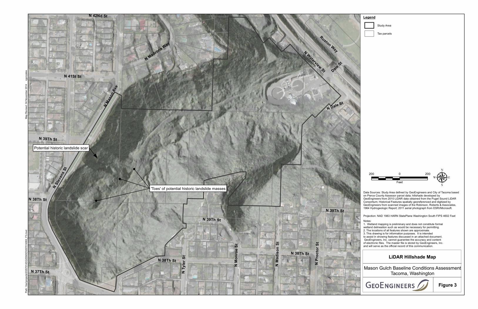
Finally, a hillshade map generated from 2010 LiDAR data (Figure 3) was reviewed. An area of potential
historic landslide masses was identified to be located at the bottom of the steep slope, on the northwest
side of the study area generally between North 38th and North 39th Street. The “toes” of the potential
historic landslide masses appear to be 100 to 200 feet wide.
Reports
The following reports were reviewed as part of the project and a summary of the information pertaining to
characteristics of Mason Gulch provided in each report is provided below.
1964 – Hydrogeologic Report, Mason Gulch, City of Tacoma Department of Public Utilities Water Division
(Robinson, Roberts & Associates, 1964)
The 1964 Hydrogeologic Report summarizes geologic and hydrologic data in the southwest portion of the
study area. The purpose of the report was to evaluate the hydrogeologic characteristics of Mason Gulch
for use as a potential City water supply source. This was completed because of the relatively high
groundwater flow from springs within the gulch area and the former ownership of the site by the Tacoma
Water Supply Company. The City purchased the site from Tacoma Water Supply in 1926. The 1964
Hydrogeologic Report consisted of a review of a previous report and a field investigation which consisted
of:
■ Sketching the gulch topography.
■ Mapping streams, springs, and pipe areas where groups of metal pipes tapped into springs. The pipe
areas are identified on Figures 2 and 4 of this report.
■ Measuring stream flow rates using temporary weir structures.
■ Drilling six borings in the base of the gulch to depths of 7 to 70 feet below ground surface (bgs) (B-1
through B-6). The boring locations are identified on Figures 2 and 4 of this report. Borings B-1 through
B-5 were backfilled. Boring B-6 was completed as a well and was pump-tested.
■ Collecting water samples from one spring and three pipe areas and submitting all samples for analysis
of iron. One of the samples was also analyzed for pH, hardness, alkalinity, manganese, chloride, nitrate,
silica and total residue.
The portion of Mason Gulch that is the focus of the report is generally southwest of the location of the
report’s boring “B-1” shown on Figures 2 and 4. This geographic area of the Gulch is where private
companies withdrew water from 1883 to 1926.
The report indicates there are two important geologic units in Mason Gulch: an “upper sandy unit” and a
“lower clayey unit”, both described in the report as being part of the “Colvos (?)” formation. The “upper
sandy unit” described by the report appears to be co-incident with Advance outwash, and the “lower clayey
unit” appears to be coincident with pre-Fraser sediments.

November 6, 2014 | Page 6 File No. 0570-140-02
The report describes and maps multiple springs, streams, and features at the site associated with
abandoned water supply infrastructure. The report divides the springs into two categories that include
“semi-perched” springs which are located above a 5-foot-thick clay layer present at approximately 200 feet
(no datum given) and lower “water table” springs present between about 110 to 185 feet. Water-supply
infrastructure included four pipe areas, where groups of horizontal to near horizontal 2-inch-diameter metal
pipes tap springs. Other infrastructure included a pump house foundation, a filled reservoir (i.e., a reservoir
that had been filled in with large gravel) and two 12-inch metal pipes that drain the filled reservoir. Finally,
a pipe labeled “North End Reservoir Spillway – 12” CI (abandoned)” is shown running generally northeast-
southwest through the study area.” We have included the infrastructure described above that is shown on
“Figure 1” of the 1964 Hydrogeologic Report on Figures 2, 4 and 5 of this report.
Figure 1 of the 1964 Hydrogeologic Report shows two drain pipes emanating from the reservoir and
indicates flow rates of 75 gpm and 550 gpm (i.e., a combined flow of 625 gpm). An additional combined
flow of 610 gpm was measured as the sum of flows from approximately a dozen other springs/streams/
pipe areas in the southwestern portion of the study area. Finally, the report references 13 approximately
monthly flow measurements ranging from 1,590 gpm to 2,040 gpm made in 1954 and early 1955 near
the “mouth of the gulch, 200 feet [from] Water Street [presently Waterview Street].”
The report also describes several historic features that were either not mapped (i.e., apparently not
observed in 1964), or only inferred at the time. These include two dug wells and a pipeline connecting the
wells to the filled reservoir, an additional pipe area near the filled reservoir, an excavated spring on the
west side of the filled reservoir, a 150-foot long tunnel excavated west from north of the filled reservoir,
and the topographic outline of a dam northeast of B-1.
The report concludes that the gulch could be developed as a resource for water using “high level” vertical
wells, “low level” vertical wells or low level horizontal wells. The author estimates that up to 2 million gallons
per day of water (1,400 gallons per minute) could be obtained through a series of wells drilled into the
water-producing layers at the site.
1965 – Report of Soils Investigation, Proposed North Side Sewage Treatment Plant, Mason Gulch Site (Dames
and Moore, 1965)
The report consisted of a site reconnaissance and 10 soil borings to investigate the proposed WWTP area
and make geotechnical recommendations regarding construction including relative stability of hillside cut
slopes. The report notes numerous springs, streams, and wet areas on and adjacent to the proposed WWTP
facility and notes that water infiltrates soils on the slopes, causing erosion and reducing soil strength. The
report also notes the side slopes of Mason Gulch contained moderately dense trees and brush.
Borings encountered between 5 and 10 feet of granular soil with organic matter (likely alluvium and/or Fan
deposits) at the surface. Ten to 15 feet of granular soils without organic matter (likely alluvium and/or Fan
deposits) were encountered beneath the granular and organic matter. Clay (likely pre-Fraser deposits) was
encountered beneath the granular soils. Abundant groundwater was encountered in the upper granular
soils and to a lesser extent in the clayey soils.
In addition to general geotechnical recommendations for the WWTP, the report indicates that the south
slope, underlain predominantly by clayey soils, could be cut at 2.5H:1V (2.5 horizontal to 1 vertical) and
November 6, 2014 | Page 7 File No. 0570-140-02
that the required ‘minor cutting’ along the north slope, predominantly in granular soils, could be cut at a
steeper slope of 2:1.
1989 – Subsurface Exploration and Geotechnical Engineering Report, Chlorine Contact Chamber Addition, North
End WWTP (Rittenhouse-Zeman & Associates, May 1989a)
The report describes surface features in the southern portion of the WWTP and included the results of three
soil borings drilled to depths of 39 to 50 feet bgs (B-1, B-2 and B-3) at the location of a proposed chlorine
contact chamber on the southern portion of the WWTP. The report indicates the WWTP was built in
approximately 1966. The report notes considerable spring and stream activity on the southern slope in the
location of the proposed chamber addition and notes that French drains are reportedly located at the base-
and mid-slope areas. The report indicates that previous reports and anecdotal information suggests
several slides occurred during construction of the WWTP, especially in the southern slope area, and that
French drains and crushed rock surfacing was therefore used for slope stability. The report notes the
southern slopes contained alder, maple, blackberries, devil’s club, nettles and horsetails.
Borings B-1 through B-3 encountered 5 to 10 feet of granular fill overlying stiff to hard clayey silt (likely pre-
Fraser sediments). Groundwater was observed at 4 to 11 feet bgs, perched in the granular soils atop the
clayey silt. The report notes potential confined, and even artesian, aquifer conditions of the clayey silt.
The report concludes conventional shoring of the southern slope represents an above-average level of risk
based on marginal slope stability. Marginal slope stability was speculated based on:
■ Observations of topography, vegetation and seepage.
■ The observation that the clayey silt that comprises the southern slope is softer than other clayey silts
in the area, including slopes on the north side of the WWTP.
■ Previous reports and anecdotal information suggesting that slides occurred during WWTP construction.
■ Observations by others of blocky fractures and slickensides (polished, grooved shear planes that result
from soil movement) in the clayey silt.
1989 – Subsurface Exploration and Geotechnical Engineering Report, North End WWTP Additions (Rittenhouse-
Zeman & Associates, December 1989b)
The report describes surface features at the WWTP, and included three test pits excavated to depths of 6
to 14 feet bgs (TP-1, TP-2 and TP-3) in the location of proposed additions in various locations at the WWTP.
The report contains much of the same information in the May 1989a report by Rittenhouse-Zeman &
Associates described above. Additional information not contained in the above report included the absence
of springs and streams north of the WWTP. Test pits TP-1 and TP-2 in the northeastern portion of the WWTP
encountered granular soils (fill and/or alluvium). TP-3 in the western portion of the WWTP encountered
clayey silt (likely pre-Fraser deposits).
2014 – Ecology Well Log Viewer (2014)
A search of Ecology’s well log viewer identified four wells located within approximately 2,000 feet of Mason
Gulch in the upland area (i.e., borings located northwest, southwest, or southeast of Mason Gulch). The
borings were drilled to depths of 20 to 176 feet bgs. In general, all borings encountered tan to brown sand,
sand and gravel, or sand with some silt within 40 feet of the ground surface (all likely Advance outwash
deposits, or Vashon till grading to Advance outwash deposits). Two of the deeper borings encountered silt

November 6, 2014 | Page 8 File No. 0570-140-02
or gray/blue clay underlying the granular soils (likely pre-Fraser deposits). Three of the well logs either
indicate “no water,” or make no indication of water. A well drilled to 176 feet bgs indicates heaving sands
at 16 to 28 feet bgs and a static water level of 144 feet bgs.
Wetlands and Aquatic Areas
The U.S. Fish & Wildlife Service (USFWS) National Wetland Inventory (NWI) dataset does not show any
wetlands or riparian areas in the study area (USFWS, 2014). City GovME online mapping database (City of
Tacoma, 2014) shows two streams—one through the central portion of the gulch and a second tributary
originating from the secondary gulch south of the WWTP. The confluence of these two streams is mapped
at the WWTP. GovME also shows extensive “high probability” wetlands throughout the central portion of
the gulch and extending to the upper rim at the western limits of the study area, into the secondary gulch
south of the WWTP, and laterally along slopes northwest and southeast from the WWTP (see Appendix C).
Vegetation
Aerial imagery covering the study area (e.g., Appendix C and Google Earth images from 2010-2013) shows
heavy forest and shrub vegetation cover throughout most of the study area, with the exception of the WWTP.
There is a landscaped strip and mowed area within the street ROW around the upper rim (North Mason
Avenue, North Stevens Street, North 37th Street and North 38th Street), and some trimmed or cleared areas
that are apparent extending into the study area from adjacent residential areas at the top of the slopes.
Previous reports for the site generally did not include significant descriptions of vegetation. However,
several of the reports present limited vegetation observations in the context of general site conditions
and/or slope stability. These reports note “moderately dense growth of trees and brush” (Dames and
Moore, 1965) and “alder and maple trees, with an undergrowth [of] blackberries, devil’s club, nettles, and
horsetails” (Rittenhouse-Zeman & Associates, 1989).
SITE CONDITIONS
Site conditions were evaluated by a licensed geologist and a professional wetland scientist/habitat biologist
during reconnaissance performed July 30 through August 1, 2014. Personnel walked the study area,
recording observations using handheld GPS technology and recording written field notes and sketches. On
the morning of July 30th we were accompanied by a WWTP employee who provided access to locked gates
and who identified features with which he was familiar on the gravel access road that runs between the
WWTP and the capped well (B-6) southwest of the WWTP. In addition to the road and well, the employee
identified the sedimentation pond and control/diversion structure, a pressure reducer approximately 60
feet west of the WWTP fenceline, eight catch basins along the road, and the filled reservoir and pump house
foundation area. The following sections describe the site conditions based on our field observations and
data review.
Soil
There were very few exposures of Advance outwash or pre-Fraser deposits in the study area, as the majority
of the area is covered in loose colluvium or alluvium. However, we were able to generally confirm the
stratigraphy as mapped by Troost based on the following:

November 6, 2014 | Page 9 File No. 0570-140-02
■ Soil exposures of very stiff gray clay (pre-Fraser sediments – likely lacustrine) observed in several deeply
incised stream channels near where the channels enter the main stream, lower in the study area.
■ Soil exposures of dense gray sand (Advance outwash) in two erosional features higher in the study
area.
■ The sandy and/or gravelly nature of colluvium on and at the base of the steeper slopes around the
perimeter of the gulch are consistent with an Advance outwash provenance.
■ Borings B-1 and B-2 performed as part of the 1964 Hydrogeologic Report encountered clay at the
surface, whereas B-3 through B-6 encountered predominantly brown or gray coarser-grained deposits
overlying clay. This indicates the contact between the Advance outwash and pre-Fraser sediments is
located between borings B-2 and B-4, which is consistent with the geologic map (see Figure 4).
We did not observe fan deposits or Vashon till. It is possible fill and/or till are located near the top of the
gulch (under and adjacent to sidewalks, etc.), however, our investigation did not identify subsurface
explorations in these areas.
We did not observe recent landslide scarps in the study area, however, we did observe the following
indications of potential slope instability (Figure 4):
■ Headward erosion at all springs
■ Recently downed (tipped) trees with uprooted root masses;
■ Localized areas of bare ground (i.e., little or no understory); and
■ Debris deposited as a result of a landslide that reportedly occurred in the early 2000s. The landslide
covered the gravel access road with mud to a depth of 2 to 3 feet in the location shown on Figure 4.
The landslide occurred during/after a period of unusually heavy rains in the winter. The debris was
later cleared from the road using construction equipment (Dave Clark, pers. Comm.). We observed that
whereas the majority of the gravel access road is elevated above the land surface on both sides, the
ground surface on both sides of the road in the vicinity of the slide was relatively flat.
We visited the areas identified by the LiDAR hillshade map (Figure 3) as potential historic landslide masses.
We observed no evidence of recent landslide activity. It should be noted that the areas were thickly
vegetated, precluding a visual examination for hummocky ground typical of landslide masses. Based on
the LiDAR hillshade map, these areas could represent older landslides. These relatively large areas could
be investigated further by observing them when vegetation cover is less, thus allowing a broader visual
view, or potentially by test pit explorations.
Groundwater and Surface Water
Numerous springs, streams and potential wetlands were observed throughout the study area (Figure 2).
The locations of springs and streams mapped in 1964 in the southwestern portion of the gulch (i.e.,
southwest of the location of B-1 on Figure 2) do not appear to have changed significantly, within the
accuracy of the mapping methodologies (i.e., sketching in 1964 and GPS technology in 2014). Pipes were
observed at three out of the four “pipe areas” mapped in 1964, as summarized in the table below. Any
discrepancies are likely due to a combination of erosion and/or deposition, pipe degradation and/or
vandalism.

November 6, 2014 | Page 10 File No. 0570-140-02
“Pipe Area” on Figure 1 in 1964
Hydrogeologic Report
Number of Pipes Shown on Figure 1
in 1964 Hydrogeologic Report
Number of Pipes Observed
in 2014
No. 1 5 5
No. 2 4 3
No. 3 2 2
No. 4 2 0
In addition to the springs, streams and pipe areas mapped in 1964, we identified previously unmapped
springs and streams northeast of B-1 and also mapped the location of potential wetlands in the gulch.
Based on the season and month of our site visit (summer/August) following an extended period of hot, dry
weather, we estimate that most streams mapped in the study area contain perennial flow in most years.
None of the streams appear to be fish-bearing, including the main channel in the bottom of the valley. The
main channel flows into the control/diversion structure associated with the WWTP from which point it is
piped underground to an outfall on Commencement Bay. The control/diversion structure is not fish
passable. Extensive wetland areas were observed in the lower slopes and valley bottom. Most wetland
areas are associated with riparian habitat forming an extensive mosaic within the central portion of the
study area (Figure 2).
Significant groundwater flow from springs is occurring and has occurred in the project area. Groundwater
flow appears to be from the Advance outwash unit. Based on this, it appears that Mason Gulch may be a
discharge point/area for the regional Vashon advance outwash aquifer which extends beneath the broad
upland area south of the site. Recharge to the aquifer is through precipitation that percolates vertically
through other overlying geologic formations (recessional outwash and glacial till) that covers the upland
area. Water within the Advance outwash aquifer generally flows from north to south in the Tacoma area.
The vertical flow of water within this unit is impeded by the impermeable pre-Fraser silt and clay layer.
Where this contact is exposed on a slope, springs can occur. Groundwater flow from springs at the site is
significant and appears to be higher than in other gulches and hillslopes in the Tacoma area, based on our
experience.
Vegetation
Mapping of the approximate distribution of vegetation communities in the study area was performed during
the site reconnaissance. Field reconnaissance and mapping of vegetation communities was not performed
on private properties in Mason Gulch. Vegetation was informally classified based on dominant strata (i.e.,
forest, shrub or herbaceous), species composition (for forested areas), predominance of native or invasive
species (shrub and wetland areas), and moisture regime (wetlands were classified separately). We also
collected point data where concentrations of invasive species were observed. These point locations
indicate occurrence of invasive species within the understory of forested areas and/or dominant or co-
dominant species in shrub or wetland areas. Point locations represent a concentration of invasive species
and should not be interpreted as representing the precise location of individual plants. The results of
mapping vegetation communities are shown on Figure 5.
The majority of the study area is comprised of two primary vegetation communities: an upland hardwood
forest dominated by bigleaf maple (Acer macrophyllum) with shrub understory and a shrub wetland
community with sparse trees and limited forest canopy cover (Figure 5). Other areas within the study area
include a landscaped grass strip at the top of the slope along North Mason Avenue, landscaped areas
November 6, 2014 | Page 11 File No. 0570-140-02
within the WWTP fence, some mowed grass and herbaceous areas along the top of the slope that are not
actively landscaped, native and invasive shrub areas in forest canopy openings as well as near the top of
the slope where forest cover has been trimmed or removed, and an area of mature forest dominated by
Douglas fir (Pseudotsuga menziesii) with a lesser component of bigleaf maple.
The general distribution of invasive species was also mapped within the study area. Invasive species are
most common near the edges of the study area where they have likely encroached from other developed
areas and in cleared portions of the interior of the study area (i.e., along the access road); however, English
holly was common throughout forested portions of the site.
Vegetation communities are described in more detail in the following sections and the distribution of these
communities as estimated in the field is shown on Figure 5.
Mature Bigleaf Maple Forest
This vegetation community dominates most non-wetland forested habitat throughout the site including the
upper side slopes of the gulch on all aspects. Bigleaf maple is the dominant tree with sub-dominant
occurrence of red alder (Alnus rubra), cascara (Rhamnus purshiana)), Douglas fir, Western red cedar (Thuja
plicata), and Pacific madrone (Arbutus menziesii). Understory vegetation includes salmonberry (Rubus
spectabilis), sword fern (Polystichum munitum), English holly (Ilex aquifolium), red huckleberry (Vaccinium
parvifolium), Indian plum (Oemleria cerasiformis), Oregon grape (Mahonia aquifolium), beaked hazelnut
(Corylus cornuta), evergreen huckleberry (Vaccinium ovatum) and salal (Gaultheria shallon).
Mature Douglas Fir Forest
This vegetation community is more limited in distribution, occurring only along the north-facing aspect of
the upper slope near North 38th and 39th Streets. It is generally similar to the bigleaf maple forest, but with
a higher proportion of Douglas fir trees and few maples. Understory is generally dominated by sword fern
and beaked hazelnut with occasional other shrubs from the suite that occurs in the bigleaf maple forest.
Trimmed Trees and Shrubs
This community is limited to the upper slopes near the top of the gulch where forest vegetation has been
trimmed adjacent to roads and residences, presumably with the purpose of improving view corridors.
Young/small bigleaf maple are common, as well as red alder, Pacific madrone on south-facing slopes and
non-native cherry trees (Prunus sp.). Shrubs include beaked hazelnut, red elderberry (Sambucus
racemosa), Cascade mountain ash (Sorbus scopulina), Himalayan blackberry (Rubus armeniacus), and an
unidentified exotic oak (Quercus sp.).
Native and Invasive Shrub Communities
Shrub communities occur in canopy clearings in otherwise forested areas as well as at the forest margin
where forest cover has been cleared adjacent to other development (roads and residences). A native shrub
community dominated by salmonberry occurs in the lower valley adjacent to the access road where historic
site use activities resulted in clearing of forest vegetation during development of water infrastructure
(reservoir, pump house and associated pipes). Invasive and mixed native and invasive shrub communities
occur in the valley bottom and side slopes, predominantly north of the stream channel and near the access
road where site use has been more intensive historically and currently as well as near the top of the slope.
Dominant or common native species include red elderberry, beaked hazelnut, thimbleberry (Rubus

November 6, 2014 | Page 12 File No. 0570-140-02
parviflorus), bracken fern (Pteridium aquilinum), sword fern, horsetails (Equisetum spp.), stinging nettle
(Urtica dioeca), and bedstraw cleaver (Galium aparine). Common non-native invasive species include
Himalayan blackberry, Scotch broom (Cytisus scoparius), common tansy (Tanacetum vulgare), and Robert
geranium (Geranium robertianum).
Wetlands
Wetland mapping did not include formal jurisdictional delineation and survey, but was performed to provide
a general understanding of aquatic habitat and drainage conditions, including approximate locations and
extents. Wetlands within the study area are predominantly native shrub systems with limited forested
wetland components and few areas dominated by non-native invasive species. Native wetlands are
dominated by salmonberry, Pacific willow (Salix lasiandra), red-osier dogwood (Cornus sericea), devil’s club
(Oplopanax horridus), skunk cabbage (Lysichiton americanus), youth-on-age (Tolmiea menziesii), false lily-
of-the-valley (Maianthemum dilatatum), small-fruited bulrush (Scirpus microcarpus), slough sedge (Carex
obnupta), lady fern (Athyrium filix-femina), and horsetails. Non-native wetland areas are typically being
encroached upon by Himalayan blackberry.
Grass and Herbaceous
Grass and herbaceous cover occurs at the top of the gulch adjacent to North Mason Avenue, North Stevens
Street, North 37th Street and North 38th Street where shrub or forest communities have been excluded
through mowing or other plant control but landscaping has not been implemented. These areas are
dominated by native and non-native grasses, Scotch broom, bracken fern, thimbleberry, fireweed
(Chamerion angustifolium), and common mullein (Verbascum thapsus).
Landscaped
A grass landscape strip occurs along North Stevens Street and North Mason Avenue. Landscaping is also
present on slopes adjacent to the WWTP that are believed to have been cut slopes that were planted with
Douglas fir trees.
Invasive Species
Point locations for concentrations of invasive species observed in the field are included on Figure 5. In
general, much of the study area is relatively intact with native vegetation dominating most of the interior
mature forested areas and riparian wetlands. The most common non-native invasive species occurring in
interior forested portions of the site is English holly. Other species are generally limited to forest edge
habitats or disturbed areas resulting from vegetation clearing activities (historic or recent). Himalayan
blackberry is common in cleared areas near the access road as well as at the top of the slope and in a few
other potentially natural canopy openings (e.g., resulting from fallen trees) where it has invaded
opportunistically. English ivy (Hedera helix) is surprisingly sparse through most of the site with occurrence
primarily limited to the northern lobe of the study area but also occurring on a few isolated trees in other
areas. Common tansy was observed in a couple of locations along the access road. Common periwinkle
(Vinca minor) was observed in one location just south of the WWTP. Ornamental bamboo (species
unknown) was observed in a couple of locations at or near the site boundary, one of which was associated
with an adjacent residence. This species likely has escaped from residential landscape areas. A Japanese
knotweed (Polygonum cuspitatum) infestation was also present in one location near the top of the slope
near North Mason Avenue, south of North 41st Street.

November 6, 2014 | Page 13 File No. 0570-140-02
Man-Made Features
Noteworthy man-made features in the study area include:
■ WWTP infrastructure and grounds. Retaining walls are located on the north and west sides of the
WWTP and a rockery is located on the southwest side of the WWTP. Although a detailed analysis was
not performed, it was noted the retaining walls were more or less vertical and without obvious cracks
and the batter of the rockery was generally uniform. On the slope south of the administration building,
a slight scarp/slump feature was observed (Figure 4). The feature was approximately 20 feet long with
a vertical relief of approximately 1 foot. Bare ground was not visible as the feature and surroundings
were covered in a very thick accumulation of pine needles.
■ Water tank north of the WWTP. The reconnaissance did not include entering the locked fence
surrounding the water tank; however, the tank and surrounding fence were observed from outside the
fence. Obvious cracks were not observed in the readily observable portions of the tank’s concrete
foundation and the tank appeared generally level and without major dents. One tree was observed to
have fallen on the south side of the tank as a result of a cracked trunk damaging a portion of the chain
link fence and brushing up against the side of the tank.
■ Fence surrounding the WWTP. The chain link fence was installed in 1966 and has only been repaired
in places where trees have fallen on it over the years (Dave Clark, pers. Comm.). It was observed that
the fence was approximately straight on the north, west, and southwest sides of the WWTP. The
southeastern portion of the fence was observed to be slightly crooked and a vertical grade separation
of approximately 3 to 18 inches was observed along the length of the fence. In several places we
observed exposed portions of fence-post concrete foundations and places where soil movement had
moved small concrete blocks and/or railroad ties that appeared to have been placed to prevent
erosion.
■ The sedimentation pond and control/diversion structure at the west end of the WWTP. Although the
flow rate was not measured, we estimate the stream flow rate into the control/diversion structure was
between 250 and 750 gpm on July 30th. The City has a permit to dredge up to 50 cubic yards of
sediment each year from the sedimentation pond and spread the sediment at an approved upland
location (City of Tacoma, 2005). The amount typically dredged is 30 cubic yards (Desiree Pooley, pers.
Comm.).
■ Gravel access road and vicinity. The gravel access road between the WWTP and the capped well (B-6)
appeared in generally good condition. At the time of our visit the road was covered with knee high
grass and other vegetation. The vegetation is reported to be mowed once per year (Dave Clark, pers.
Comm.). Tension cracks, soil erosion, or other signs of immediate slope stability issues were not
observed. Water accumulates in a ditch that runs the majority of the north side of the road and seven
catch basins and culverts allow water to flow to the south side of the road and discharge in streams
toward the main stream. The WWTP personnel use a shovel to clear debris from some or all of the
catch basins at least once per year. Personnel indicated that a landslide in the early 2000s covered
the gravel access road with mud to a depth of 2 to 3 feet in the location shown on Figure 4. The
landslide occurred during/after a period of unusually heavy rains in the winter. The debris was later
cleared from the road using construction equipment (Dave Clark, pers. Comm.). It was observed that
whereas the majority of the gravel access road is elevated above the land surface on either side, the
ground surface on either side of the road in the vicinity of the slide was relatively flat.

November 6, 2014 | Page 14 File No. 0570-140-02
■ Filled reservoir and drain pipes. The filled reservoir was evident as a conspicuous, relatively flat area.
A stream flows along the north side of the filled reservoir then disappears into the ground where the
west end of a drain pipe is mapped in the 1964 Hydrogeologic Report. We excavated approximately
1 foot where the water disappears into the ground; however, we were not able to find an inlet structure
such as a catch basin. We found at-grade portions of the drain pipe to the east, and we also found the
outlet of the drain pipe (near B-2 on Figure 2). The end of the 12-inch metal pipe was choked with thick
vegetation including moss, and flow was difficult to discern, although it was substantially less than the
75 gpm noted in the 1964 Hydrogeologic Report. The outlet from the other 12-inch metal drain pipe
to the south is located in the same area. We estimated the flow to be at least several hundred gallons
per minute.
■ Pump house foundation. We observed concrete structures that housed a 12-inch metal pipe with
valves. At the time of our visit a large maple cluster had fallen on top of the pump house foundation.
■ Capped well (B-6). We observed a 6-inch-diameter, approximately 3-foot high metal stickup well
monument at the location of B-6. The top of the monument consisted of a welded metal plate. The
well monument was generally straight and vertical.
■ Abandoned water distribution pipe. We observed water valves and/or pressure reducers (air relief
valves) at the top and near the bottom of the study area (i.e., north of the intersection of North 37th
Street and North Stevens Street and also west of the WWTP on the gravel access road – see Figure 2).
The valves and/or pressure reducers are associated with an abandoned water distribution pipe.
According to City personnel, the pipe is an 18-inch-diameter steel pipe that was installed in 1927 (Ryan
Flynn, pers. Comm.). The pipe was used as a main water transmission line until 2014, when it was
abandoned. City personnel indicated the pipe may be 18 inches in diameter near the top of the gulch,
and reduced to 12 inches in diameter lower in the gulch. A portion of the pipeline is shown in the 1964
Hydrogeologic Report Figure 1 and is labeled “North End Reservoir Spillway – 12” CI (abandoned);”
(Figures 2 and 4).
■ Wood stave pipe. At-grade segments of an old wood stave pipe are visible in three locations in and at
the bottom of a small ravine in the southwest portion of the study area. At the time of our visit there
was a hole in the top of the pipe at the upper-most segment that permitted observation of the interior
of the pie. The pipe did not contain water. The two lower segments were intact and thus did not permit
observation of the pipe interior; however, it was noted there was wet ground and a small stream in the
general vicinity of the pipe.
■ Concrete debris. Small amounts of concrete debris were observe in the locations shown on Figure 2.
Debris ranged from small portions of concrete panels less than several square feet in size to hollow
structures that measure several feet across.
■ Trails. Formal trails (i.e., engineered and well maintained) were not observed in the study area.
Numerous “social” and/or animal trails were observed. Some of the more obvious established “social”
and/or animal trails are located south and southwest of the WWTP as shown on Figure 2. Other trails
are generally intermittent and likely the result of deer or other wildlife activity as much as any human
activity and were not mapped.
■ Top-of-gulch features:
Concrete foundation. A 200- to 300-square foot concrete foundation was observed at the top
of the gulch near North 39th Street. It is possible the foundation was formerly associated with
the water supply infrastructure in use in the early 1900s. The foundation was cracked, and

November 6, 2014 | Page 15 File No. 0570-140-02
various portions of the foundation were tilted 2 to 10 degrees from horizontal, generally
towards the middle of the foundation.
Metal posts. Two 3-inch, approximately 4-foot high near-vertical metal posts were observed at
the top of the gulch near North 39th Street. The northernmost post was bent as if it had been
struck. The southernmost post did not appear bent but was leaning from vertical approximately
10 degrees to the east (i.e., toward Mason Gulch).
Fences, guard rails, sign posts, light poles, sidewalks and streets. Fences and guard rails were
generally straight, sign posts and light poles were vertical or near vertical, and streets and
sidewalks were not significantly cracked or degraded. There are no utility poles.
Guard-rail retaining walls. Three sections of retaining walls comprised of guard rails and other
material were observed along the top of the gulch. The materials appear to have been
constructed at locations where the steep, upper portion of Mason Gulch comes relatively close
to the street ROWs. One guard rail wall that is approximately 50 feet long is located north of
North 38th Street. To the south is another guard rail wall approximately 65 feet long. Just
south of that wall is a third wall comprised of two 5-foot long sections of guard rail separated
by a distance of approximately 5 feet. Concrete debris with an asphalt surfacing is located
between the two 5-foot sections of guard rail wall. The asphalt extends downslope for
approximately 10 feet. All guard rail walls appeared generally straight. The southern wall is
notable as it appears to be an access point to the gulch, and an area of destabilized slope is
located below it (see “Slope Stability,” below).
MANAGEMENT CONSIDERATIONS
Slope Stability
The Ecology Coastal Zone Atlas maps the steep upper portions of Mason Gulch as “unstable.” Furthermore,
the majority of Mason Gulch would likely be considered a landslide hazard area based on the City of
Tacoma’s Critical Areas Ordinance. The results of our data review and observations support previous
mapping and designation efforts that characterize slopes in the study area as unstable. Relevant
observations and information include:
■ Historical descriptions of landslide events. The May 1989 geotechnical engineering report
(Rittenhouse-Zeman & Associates, 1989a) indicates that landslides occurred during construction of
the WWTP. WWTP personnel we interviewed on July 30, 2014 recalled at least one landslide that
covered the gravel access road with 2 to 3 feet of mud in the early 2000s (Figure 4).
■ The presence of significant groundwater seepage from springs at the study area, both historically and
presently (2014). Spring flow was sufficient for a water supply company to develop the study area for
water supply from 1883 to 1926. The 1964 Hydrogeologic report estimated that the gulch could supply
approximately 1,400 gpm of water. The springs originate where permeable Advance outwash deposits
overly relatively impermeable pre-Fraser deposits. This stratigraphic sequence, particularly where
spring flow is significant, can be and is a primary cause of landslides in the Puget Sound region. It is
our opinion that the existing pipes in the study area, including the four ‘pipe areas’ and the two pipes
that drain the former reservoir, have likely helped maintain slope stability in localized areas by lowering
the water table. As the pipes degrade there is the potential their ability to drain water will diminish,
thus decreasing slope stability in those areas. The insertion of horizontal drains into a permeable,
landslide-prone geologic formation is a primary landslide mitigation/reduction methodology in the
Puget Sound region.

November 6, 2014 | Page 16 File No. 0570-140-02
■ Headward erosion at springs. At each spring, headward erosion is causing over-steepened and in some
cases undermined soil conditions and eventually soil sloughs off in localized landslides.
■ Leaning, butt-bowed, or recently fallen trees. Most trees in the study area are either leaning or butt-
bowed (the base of the tree is bent, likely as a result of slope creep). The location of recently fallen
trees is shown on Figure 4.
■ Bare ground. Localized areas of bare ground are an indication of potential soil creep or erosion. These
areas are shown on Figure 4. The most prominent bare ground feature in the study area is located
below an access point near a guard rail/concrete/asphalt retaining wall structure south of 38th Street.
In our opinion the area should be stabilized to prevent further erosion. Stabilization could include
revegetation, engineered soil stabilization, and/or control and/or diversion of surface water flow onto
the area from above (i.e., from the access point which is currently concentrating stormwater flows onto
the bare ground area below).
■ Man-made features. The majority of man-made features observed in and at the top of the study area
do not appear to be affected by the adjacent gulch at present. Exceptions include the chain link fence
south of the WWTP, the cracked and tilted concrete foundation located at the top of the gulch north of
North 39th Street, and the leaning 3-inch-diameter metal post also located at the top of the gulch north
of North 39th Street. (The adjacent 3-inch-diameter post is more difficult to use as an indicator of slope
stability as it has obviously been struck and bent.)
The project area may be more susceptible to landsliding primarily because of the significant amount of
groundwater flow emanating from springs throughout the gulch. As previously stated, one of the primary
causes of slope instability in Puget Sound is groundwater flow, on a slope, from springs. Based on the
information reviewed it appears that significant spring flow at the site has occurred at least since 1883.
Landslides occurring in this geologic setting likely include earth/mud flows, which are common in Puget
Sound and do not require spring flow. Landslides in this geologic setting can also include larger rotational
failures, which can occur when a surge in groundwater flow from the Advance outwash is discharged
through the springs. Landsliding, in general, is expected to be more significant in Mason Gulch primarily
because of the abundant presence of groundwater springs at the site.
The WWTP utilizes water flowing through Mason Gulch and is interested in the likelihood of an event such
as a landslide interrupting the water supply to the control/diversion structure that supplies water to the
50,750-gallon water tank located north of the plant. The WWTP uses only 30 gpm of the much larger flow
entering the control/diversion structure (250 to 750 gpm on July 30, 2014). A relatively large landslide not
far upgradient of the control/diversion structure would be required to reduce stream flow into the control/
diversion structure to less than 30 gpm. Such a landslide is possible but is relatively unlikely, in our opinion.
Public Access
Increased public access to Mason Gulch, would require construction of trails. In our opinion trail
construction in the Mason Gulch is not infeasible; however, construction and maintenance may be more
expensive in the study area compared to other similar Tacoma slopes such as Schuster Slope or Puget
Park. While slope gradients and geologic materials are similar amongst all three areas, the total elevation
change is greatest in Mason Gulch. Furthermore, extensive groundwater seepage and surface water
drainage channels present across all slope aspects may result in increased need for engineered solutions
to trail development and more regular and costly maintenance. Wetlands, stream channels, and regulatory
critical area buffers also increase the cost and permitting of trail development.

November 6, 2014 | Page 17 File No. 0570-140-02
SUMMARY
GeoEngineers performed a baseline assessment of geologic and biologic conditions in the study area.
Existing reports and maps describe historic landslide activity/unstable slopes and we observed signs of
slope instability during our site reconnaissance including significant spring activity on and at the base of
steep slopes. Stratigraphy in the study area – permeable soils overlying impermeable soils – is a cause of
the observed hydrogeology and a contributing factor for multiple Puget Sound landslides.
The majority of the study area is covered in heavy forest and shrub vegetation with localized areas of
landscaping and bare ground. The predominant vegetation communities include hardwood forest
dominated by bigleaf maple with shrub understory and shrub wetland community with sparse trees and
limited forest canopy cover. Invasive species are present near the edges of the study area and along a
gravel access road in the study area.
LIMITATIONS
We have prepared this baseline assessment report for use by the City of Tacoma. Within the limitations of
scope, schedule and budget, our services have been executed in accordance with generally accepted
practices in the fields of engineering geology and biologic sciences in this area at the time this report was
prepared. No warranty or other conditions, express or implied, should be understood.
Please refer to Appendix D titled “Report Limitations and Guidelines for Use” for additional information
pertaining to use of this report.
REFERENCES
City of Tacoma. 2005. Operations Plan for Mason Creek Sediment Removal Project, HPA Control
#103477-1.
City of Tacoma. 2014. GovME Web Mapping Printout: Streams and Wetlands. http://govME.org/map.
Accessed July 23, 2014.
Dames and Moore. 1965. Report of Soils Investigation: Proposed North Side Sewage Treatment Plant,
Mason Gulch Site, Tacoma, Washington. March 18, 1965.
Dave Clark, personal communication.
Desiree Pooley, personal communication.
Rittenhouse-Zeman & Associates, Inc. 1989a. Subsurface Exploration and Geotechnical Engineering
Report: Chlorine Contact Chamber Addition, North End Wastewater Treatment Plant, Tacoma,
Washington. May 1989.
Rittenhouse-Zeman & Associates. December 1989b. Subsurface Exploration and Geotechnical
Engineering Report, North End WWTP Additions.

November 6, 2014 | Page 18 File No. 0570-140-02
Robinson, Roberts & Associates. 1964. Hydrogeologic Report, Mason Gulch, City of Tacoma Department
of Public Utilities Water Division.
Ryan Flynn, personal communication.
Troost, K. In review. Geologic Map of the Tacoma North 7.5-minute Quadrangle, Washington. 2004
Draft.
U.S. Fish and Wildlife Service. 2014. National Wetlands Inventory. Accessed August 20, 2014.
Washington State Department of Ecology. 1979. Coastal Zone Atlas. http://www.ecy.wa.gov/
programs/sea/landslides/maps/maps.html. Accessed July 23, 2014.
Washington State Department of Ecology. 2014. Well Log Viewer. https://fortress.wa.gov/ecy/
waterresources/map/WCLSWebMap/default.aspx Accessed July 23, 2014.

Vicinity Map
Figure 1
W a s h i n g t o n
O r e g o n
I d a h o1 10
Miles
Data Sources: ESRI Data & Maps, Street Maps 2005
Notes:1. The locations of all features shown are approximate.2. This drawing is for information purposes. It is intended to assist in showing features discussed in an attached document. 3. It is unlawful to copy or reproduce all or any part thereof, whether for personal use or resale, without permission.
Transverse Mercator, State Plane South, North American Datum 1983North arrow oriented to grid north
Study Area
Mason Gulch Baseline Conditions AssessmentTacoma, Washington
Path:
\\tac
\Proj
ects\
0\057
0140
\GIS
\MXD
\0570
1400
2_F1
_VM.
mxd
Map R
evise
d: 14
Augu
st 20
14
dcon
lin

Sediment pond andcontrol/diversion structure
Concrete foundation
12" wood stave pipeobserved in 3 locationsBroken 5" metal pipe
N St
even
s St
140160180
130
140
150
160
170180190210230250260270
290
100110
130140150
200220
240250
10
50
310300
260
270
320
170
300
300
310
300
310
310
300300
180
190200
220
230
30
130110
120
10
240
240
250
30
60
80
250
320
320
150
160
320
290
260
10
10240
40
280
90100
170180
310310
320320320
310
310
240
270
310
310320
320
310
300
70
170190
200
210230
260280
280290
120
300
220210
50
60
160
190200210220
230
90
Ruston Way
N 37Th St
N Steve
nsSt
N Mas
on Av
e
N 38Th St
N 39Th StN 39Th St
N Mo
nroe
St
N Waterview St Dale St
N Pr
octor
St
N 38Th St
N 39Th St
N 41St St
N Ty
ler S
t
N Madrona Way
N Dale St
N 38Th St
N Ma
dison
St
N 42Nd St
1
2 3
4
B-1
B-2
B-4
B-5
B-3B-6
General ConditionsMason Gulch Baseline Conditions Assessment
Tacoma, Washington
Figure 2
200 0 200
Feet
Legend
Study Area10-ft contours(NAVD 88)
Historical Features1964 soil boring(backfilled)1964 pump test well(capped)Former reservoirand pump houseNorth end reservoir spillway12" CI (abandoned)
Pipe Areas
Other drain pipe
Field ObservationsMetal post(s)
Catch basin
Pressure reducer/air valve
Water valve
Water tank
Concrete debris
Pipe
Culvert
Access road
Trail
Fence
Retaining wall
Stream
Sediment pond
Wetlands1
Path:
\\tac
\Proje
cts\0\
0570
140\G
IS\MX
D\05
7014
002_
F2.m
xdMa
p Rev
ised:
28 Au
gust
2014
dc
onlin
Notes:1. Wetland mapping is preliminary and does not constitute formalwetland delineation such as would be necessary for permitting.2. The locations of all features shown are approximate.3. This drawing is for information purposes. It is intendedto assist in showing features discussed in an attached document. GeoEngineers, Inc. cannot guarantee the accuracy and contentof electronic files. The master file is stored by GeoEngineers, Inc.and will serve as the official record of this communication.
Projection: NAD 1983 HARN StatePlane Washington South FIPS 4602 Feet
Data Sources: Study Area defined by GeoEngineers and City of Tacoma based on Pierce County Assessor parcel data; topographic contours developed by GeoEngineers from 2010 LiDAR data obtained from the Puget Sound LiDAR Consortium; Historical Features spatially georeferenced and digitized by GeoEngineers from scanned images of the Robinson, Roberts & Associates, 1964 Hydrogeologic Report; 2011 aerial photograph from ESRI/Microsoft.
1
!
'Toes' of potential historic landslide masses
!
!
Potential historic landslide scar
Ruston Way
N 37Th St
N Steve
nsSt
N Mas
on Av
e
N 38Th St
N 39Th StN 39Th St
N Mo
nroe
St
N Waterview St Dale St
N Pr
octo
r St
N 38Th St
N 39Th St
N 41St St
N Ty
ler S
t
N Madrona Way
N Dale St
N 38Th St
N Ma
dison
St
N 42Nd St
LiDAR Hillshade MapMason Gulch Baseline Conditions Assessment
Tacoma, Washington
Figure 3
µ200 0 200
Feet
Legend
Study Area
Tax parcels
Path:
\\tac
\proje
cts\0\
0570
140\G
IS\MX
D\05
7014
002_
F3.m
xdMa
p Rev
ised:
04 N
ovem
ber 2
014
cgo
nzale
s
Notes:1. Wetland mapping is preliminary and does not constitute formalwetland delineation such as would be necessary for permitting.2. The locations of all features shown are approximate.3. This drawing is for information purposes. It is intendedto assist in showing features discussed in an attached document. GeoEngineers, Inc. cannot guarantee the accuracy and contentof electronic files. The master file is stored by GeoEngineers, Inc.and will serve as the official record of this communication.
Projection: NAD 1983 HARN StatePlane Washington South FIPS 4602 Feet
Data Sources: Study Area defined by GeoEngineers and City of Tacoma based on Pierce County Assessor parcel data; hillshade developed by GeoEngineers from 2010 LiDAR data obtained from the Puget Sound LiDAR Consortium; Historical Features spatially georeferenced and digitized by GeoEngineers from scanned images of the Robinson, Roberts & Associates, 1964 Hydrogeologic Report; 2011 aerial photograph from ESRI/Microsoft.

Sediment pond andcontrol/diversion structure
Concrete foundation
Broken 5" metal pipe
Qvt
Qva Qpf QfSlight slump/scarp feature
!
Soil exposure
!
Soil exposure
!
Soil exposure
!
Soil exposureLandslide debris
12" wood stave pipeobserved in 3 locations
140160180
130
140
150
160
170180190210230250260270
290
150
200220
240250
50
310300
260
270
320
170
300
300
310
300
310
300
180
190200
220
230
30
130110
120
240
240
250
30
60
80
250
320
320
150
160
320
290
260
10
240
40
280
90100
170180
310310
320320320
310
310
240
270
310
310320
320
310
300
70
170190
200
210230
260280
280290
300
220210
50
60
160
190200210220
230
Ruston Way
N 37Th St
N Steve
nsSt
N Mas
on Av
e
N 38Th St
N 39Th StN 39Th St
N Mo
nroe
St
N Waterview St Dale St
N Pr
octo
r St
N 38Th St
N 39Th St
N 41St St
N Ty
ler S
t
N Madrona Way
N Dale St
N 38Th St
N Ma
dison
St
N 42Nd St
1
2 3
4
B-1
B-2
B-4
B-5
B-3B-6
T
T TT
T
T
T
T
Geologic ConditionsMason Gulch Baseline Conditions Assessment
Tacoma, Washington
Figure 4
µ200 0 200
Feet
Legend
Study Area10-ft contours(NAVD 88)
Historical Features?
1964 soil boring(backfilled)
A1964 pump test well(capped)Former reservoirand pump houseNorth end reservoir spillway12" CI (abandoned)
Pipe Areas
Other drain pipe
Field ObservationsMetal post(s)
") Catch basin
$1 Pressure reducer/air valve
$1 Water valve
!( Water tank
j Concrete debris
X Areas of recentlycut trees
T Recently downedtree and root mass
Geologic contacts
Pipe
Culvert
Access road
Trail
}} }} }} Fence
Retaining wall
Stream
Sediment pondBare ground(little or no understory)
Path:
\\tac
\proje
cts\0\
0570
140\G
IS\MX
D\05
7014
002_
F4.m
xdMa
p Rev
ised:
06 N
ovem
ber 2
014
cgo
nzale
s
Notes:1. Geologic contacts should be considered approximate and are based on Troost (in review), modified based on field observations. See report text.2. The locations of all features shown are approximate.3. This drawing is for information purposes. It is intendedto assist in showing features discussed in an attached document. GeoEngineers, Inc. cannot guarantee the accuracy and contentof electronic files. The master file is stored by GeoEngineers, Inc.and will serve as the official record of this communication.
Projection: NAD 1983 HARN StatePlane Washington South FIPS 4602 Feet
Data Sources: Study Area defined by GeoEngineers and City of Tacoma based on Pierce County Assessor parcel data; topographic contours developed by GeoEngineers from 2010 LiDAR data obtained from the Puget Sound LiDAR Consortium; Historical Features spatially georeferenced and digitized by GeoEngineers from scanned images of the Robinson, Roberts & Associates, 1964 Hydrogeologic Report; 2011 aerial photograph from ESRI/Microsoft.
!(1
Geology Key1
Qf - fan depositsQpf - pre-Fraser sedimentsQva - advance outwashQvt - Vashon till

N St
even
s St
Ruston Way
N 37Th St
N Steve
nsSt
N Mas
on Av
e
N 38Th St
N 39Th StN 39Th St
N Mo
nroe
St
N Waterview St Dale St
N Pr
octor
St
N 38Th St
N 39Th St
N 41St St
N Ty
ler S
t
N Madrona Way
N Dale St
N 38Th St
N Ma
dison
St
N 42Nd St
1
2 3
4
Vegetation MappingMason Gulch Baseline Conditions Assessment
Tacoma, Washington
Figure 5
200 0 200
Feet
Legend
Study Area
Pipe Areas
Other drain pipe
Stream
Culvert
Access road
Fence
Invasive SpeciesBamboo
Common periwinkle
Common tansy
English holly
English ivy
Himalayan blackberry
Japanese knotweed
Vegetation CommunitiesMature bigleaf maple forest
Mature Douglas fir forest
Trimmed trees and shrubs
Native shrubs
Native and invasive shrubs
Invasive shrubs
Native wetland
Invasive shrub wetland
Grass and herbaceous
Landscaped
Developed
Path:
\\tac
\Proje
cts\0\
0570
140\G
IS\MX
D\05
7014
002_
F5.m
xdMa
p Rev
ised:
28 Au
gust
2014
dc
onlin
Notes:1. Wetland mapping is preliminary and does not constitute formalwetland delineation such as would be necessary for permitting.2. The locations of all features shown are approximate.3. This drawing is for information purposes. It is intendedto assist in showing features discussed in an attached document. GeoEngineers, Inc. cannot guarantee the accuracy and contentof electronic files. The master file is stored by GeoEngineers, Inc.and will serve as the official record of this communication.
Projection: NAD 1983 HARN StatePlane Washington South FIPS 4602 Feet
Data Sources: Study Area defined by GeoEngineers and City of Tacoma based on Pierce County Assessor parcel data; topographic contours developed by GeoEngineers from 2010 LiDAR data obtained from the Puget Sound LiDAR Consortium; Historical Features spatially georeferenced and digitized by GeoEngineers from scanned images of the Robinson, Roberts & Associates, 1964 Hydrogeologic Report; 2011 aerial photograph from ESRI/Microsoft.
1

APPENDIX A Geologic Map

Approximate location of study area showing, from the bottom up: Qf – Fan deposits; Qpf – Sedimentary deposits of pre-Fraser glaciation age; Qva – Advance outwash deposits; and Qvt – Till.

APPENDIX B Coastal Zone Atlas

Page 1 of 1
8/19/2014http://www.ecy.wa.gov/programs/sea/femaweb/Pierce/PI_2Aith.jpg

APPENDIX C City of Tacoma GovME Map

RUSTON WAY
NORTH 37TH STREET
RUSTON WAY
NO. 39TH STREET
NORTH 38TH STREET
MO
NR
OE
STR
EE
T
MA
DIS
ON
STR
EE
T
TYLE
R S
T RE
ET
NORTH 37TH STREET
NORTH 38TH STREET
NORTH 37TH STREET
NORTH 38TH STREET
RUSTON WAY
WATERVIEW STREETVINE S
TREET
DALE STREET
MADRONA
WAY
NORTH 37TH ST.
NORTH 41ST. STREET
NORTH 39TH STREET
NORTH 38TH STREET
STE
VE
NS
ST R
EE
T
VE
RD
E S
TRE
ET
CH
EY
EN
NE
STR
EE
T
GO
VE
STR
EE
T
MAS
ON
AVEN
UE
NORTH 37TH ST.
GO
VE
STR
EE
T
NORTH 44TH STREET
NORTH 43RD STREET
NORTH 43RD STREET
VE
RD
E S
TRE
STE
VE
NS
ST
NORTH 42ND STREET
MA
SO
N A
VE
NU
E
ALKI STREET
WATERVIEW
STREET
http://govME.org/mapProperty
AddressParcel
Building & Land Use (BLUS)Pierce County Water Boundaries
Critical AreasStreams (City)Wetlands
FilledHigh ProbabilityKnownNon-Jurisdictional
StreetAbc Street Name
PW Off Street LineStreet CenterlineHighway
Mason Gulch - Wetlands & Streams
Monday, June 30, 2014 2:03 PM
SCALE 1 : 8,234
0500 500 1,000 1,500FEET

APPENDIX D Report Limitations and Guidelines for Use

November 6, 2014 | Page D-1 File No. 0570-140-02
APPENDIX D
REPORT LIMITATIONS AND GUIDELINES FOR USE
This appendix provides information to help you manage your risks with respect to the use of this report.
Geologic and Biologic Services are performed for specific purposes, persons and projects
This report has been prepared for use by the City of Tacoma. This report is not intended for use by others,
and the information contained herein is not applicable to other sites.
GeoEngineers structures our services to meet the specific needs of our clients. No one except the City of
Tacoma and their agents should rely on this report without first conferring with GeoEngineers. This report
should not be applied for any purpose or project except the one originally contemplated.
Geologic and/or Biologic Reports are Based on a Unique Set of Project-Specific Factors
This baseline conditions assessment report has been prepared the area of sloping ground in the City of
Tacoma as described in this document. GeoEngineers considered a number of unique, project-specific
factors when establishing the scope of services for this project and report. Unless GeoEngineers specifically
indicates otherwise, do not rely on this report if it was:
■ not prepared for you,
■ not prepared for your project,
■ not prepared for the specific site, or
■ completed before important project changes were made.
If important changes are made after the date of this report, GeoEngineers should be given the opportunity
to review our interpretations and recommendations and provide written modifications or confirmation, as
appropriate.
Subsurface, Surface Geologic and Biologic Conditions Can Change
This report is based on conditions that existed at the time the study was performed. The findings and
conclusions of this report may be affected by the passage of time, by manmade events such as construction
on or adjacent to the site, or by natural events such as floods, earthquakes, slope instability or groundwater
fluctuations. Always contact GeoEngineers before applying a report to determine if it remains applicable.
Most Geologic and Biologic Findings are Professional Opinions
Our interpretations of surface and subsurface conditions are based on field observations from widely
spaced locations at the site. GeoEngineers reviewed the observational and map data and then applied our
professional judgment to render an opinion about subsurface conditions throughout the site. Actual
subsurface conditions may differ, sometimes significantly, from those indicated in this report. Our report,
conclusions and interpretations should not be construed as a warranty of the subsurface conditions.

November 6, 2014 | Page D-2 File No. 0570-140-02
Read These Provisions Closely
Some clients, design professionals and contractors may not recognize that the geoscience practices
(geology and biology) are far less exact than other engineering and natural science disciplines. This lack of
understanding can create unrealistic expectations that could lead to disappointments, claims and disputes.
GeoEngineers includes these explanatory “limitations” provisions in our reports to help reduce such risks.
Please confer with GeoEngineers if you are unclear how these “Report Limitations and Guidelines for Use”
apply to your project or site.
Recommended


![Baseline Assessment 1[1]](https://img.pdfslide.net/doc/110x75/577d241d1a28ab4e1e9baad7/baseline-assessment-11.jpg)