Benson Parish
Neighbourhood Plan
October 2017

Benson Parish Neighbourhood Plan �
2018-2033 �
2 of 90 Submission Version 1
October 2017
Benson Parish Neighbourhood Plan 2018–2033
This Neighbourhood Plan is published by Benson Parish Council for Final Submission
Consultation under the Neighbourhood Planning (General) Regulations 2012 and in
accordance with EU Directive 2001/42.
October 2017

� Benson Parish Neighbourhood Plan
� 2018-2033
Submission Version 1 3 of 90 October 2017
Table of Contents
Benson Parish Neighbourhood Plan 2018–2033 ............................................................. 2
1. Executive Summary ................................................................................................. 6
Our Ambitions........................................................................................................... 6
Sustainable Development ......................................................................................... 6
The Benson Relief Road .......................................................................................... 7
2. Foreword .................................................................................................................. 8
Our Vision ................................................................................................................ 8
3. List of Policies .......................................................................................................... 9
4. Introduction & Background ..................................................................................... 11
The Pre-Submission Plan ....................................................................................... 12
5. The Neighbourhood Area ....................................................................................... 13
6. Planning Policy Context .......................................................................................... 15
7. Community Views on Planning ............................................................................... 19
8. Vision and Objectives ............................................................................................. 21
Vision ..................................................................................................................... 21
Objectives .............................................................................................................. 21
9. Land Use Policies ................................................................................................... 23
Introduction ............................................................................................................ 23
Housing Allocation Policy ....................................................................................... 23
Site Allocations ....................................................................................................... 25
Land to the north of Littleworth Road (Site BEN1 Phase 2) ..................................... 26
Land off Hale Road (Site BEN2) ............................................................................. 30
Land North and North East of The Sands (Sites BEN 3 / BEN4) ............................. 33
Land to the south of St Helen’s Avenue (Site BEN7) .............................................. 36
10. Conservation and Heritage ..................................................................................... 38
11. Design .................................................................................................................... 41
12. Infrastructure Policies ............................................................................................. 43
Transport ................................................................................................................ 43
Transport Policies ................................................................................................... 44
Benson Parish Neighbourhood Plan �
2018-2033 �
4 of 90 Submission Version 1
October 2017
Traffic Flow & Pinch Points ..................................................................................... 44
Parking ................................................................................................................... 49
Sustainable Transport ............................................................................................ 50
Accessibility ............................................................................................................ 51
Public Transport ..................................................................................................... 52
River Transport ....................................................................................................... 53
Air Transport ........................................................................................................... 53
Pedestrians & Cyclists ............................................................................................ 53
Sustainable Travel .................................................................................................. 54
Road Safety ............................................................................................................ 54
13. Community Facilities' Policies ................................................................................ 58
Education ............................................................................................................... 62
Key Issues .............................................................................................................. 65
Benson Library ....................................................................................................... 65
Village Centre ........................................................................................................ 67
Assets of Community Value ................................................................................... 68
Burial Ground ......................................................................................................... 69
Doctors Surgery ..................................................................................................... 69
Phone and Broadband Provision ............................................................................ 70
Allotments .............................................................................................................. 71
Outdoor Recreation ................................................................................................ 72
14. Environmental Policies ........................................................................................... 74
Introduction to Green Infrastructure ........................................................................ 74
Benson Community Views on Green Infrastructure ................................................ 75
Benson’s Approach to Green Infrastructure ............................................................ 76
Strategy for People and Nature in Benson ............................................................. 76
Local Green Spaces and Connections to the Wider Countryside ........................... 77
Protecting Existing Green Spaces .......................................................................... 77
Creating New Green Spaces .................................................................................. 79
Biodiversity – Nature in Benson ............................................................................. 80
Context ................................................................................................................... 80

� Benson Parish Neighbourhood Plan
� 2018-2033
Submission Version 1 5 of 90 October 2017
Summary of Assets ................................................................................................. 81
Landscape Setting and Character .......................................................................... 83
Distinctiveness of Settlements ................................................................................ 83
Important Views ...................................................................................................... 84
Scope for development ........................................................................................... 86
Drainage and Flood Risk Management .................................................................. 88
Note on Agriculture ................................................................................................. 89
15. Appendices ............................................................................................................ 90
Appendix A – Sites Assessment ............................................................................. 90
Appendix B – Design Statement ............................................................................. 90
Appendix C – Heritage Study ................................................................................. 90
Appendix D – Community Questionnaire Report .................................................... 90
Appendix E – Character Assessment ..................................................................... 90
Appendix F – Transport Assessment ...................................................................... 90
Appendix G – Parking Plan..................................................................................... 90
Appendix H – Map of Sustainable Transport .......................................................... 90
Appendix I – Community Facilities .......................................................................... 90
Appendix J – Parish Allotment Usage Data ............................................................ 90
Appendix K – Green Infrastructure & Biodiversity Audit .......................................... 90
Appendix L – Benson’s Strategy for People and Nature ......................................... 90
Benson Parish Neighbourhood Plan �
2018-2033 �
6 of 90 Submission Version 1
October 2017
1. Executive Summary
The submitted Plan represents the views of the local community with regard to the future
of Benson up to 2033. It has been prepared by the Parish Council and with extensive
support from the local people, statutory bodies and the development industry. In our
view, it represents a strong and robust approach to the Localism agenda. Within this
context it has been designed to deliver the emerging South Oxfordshire Local Plan
(2011-2033) in the Benson Neighbourhood Plan area.
Our Ambitions
The Plan has been designed to be a planning, land use document. However, within this
important context it delivers several overlapping community ambitions in Benson as
follows:
� A wish to plan positively for growth rather than to respond on an ad hoc basis to
unplanned growth and development;
� A wish to bring forward the implementation of its relief road through additional
housing development beyond that which is strategically required in the emerging
Local Plan;
� An ambition to reduce the impact of through traffic on the B4009 in our village in
general, and in its centre in particular (See Appendix F);
� An ambition to enhance the vitality and viability of its village centre;
� A wish to safeguard the rural character of the village.
Sustainable Development
The submitted Plan has paid particular attention to delivering sustainable development in
the neighbourhood area. We recognise its importance in both national and local planning
policies. We are confident that the Plan and its suite of policies will deliver sustainable
development within the context of its three dimensions as set out in the NPPF as follows:
With regard to the economic dimension of sustainable development the Plan will:
� Deliver approximately 565 new houses;
� Provide considerable assistance in securing a 5-year housing land supply
in the District;
� Benson Parish Neighbourhood Plan
� 2018-2033
Submission Version 1 7 of 90 October 2017
� Provide the context for the revitalisation of the village centre through a
reduction in through traffic and increase in the population base of the
village.
With regard to the social dimension of sustainable development the Plan will:
� Deliver much-needed new affordable housing.
� Enhance the ability of local people to enjoy the character, the appearance
and the services in the village centre.
� Enhance access to recreational facilities.
With regard to the environmental dimension of sustainable development the Plan will:
� Deliver high quality design in new developments;
� Safeguard the character and appearance of the Benson Conservation
Area;
� Safeguard ecology and biodiversity assets in the Plan area;
� Designate Local Green Spaces;
� Maintain the separation between Benson and surrounding settlements;
� Define the new edge of Benson with a landscape buffer.
The Benson Relief Road
This proposal is a key element of the Plan. The emerging South Oxfordshire Local Plan
proposes that a line for this route is safeguarded. The submitted Neighbourhood Plan
takes this proposal a step further. The identification of new housing sites will collectively
secure the delivery of this route.
Benson has particular transportation issues. It is located at the junction of the A4074
Oxford to Reading road and the B4009 which links the village to the M40 to the east.
During the development of the Plan it became clear significant development outside
Benson (such as Chalgrove Airfield, Berinsfield & Culham) would have significant traffic
flow implications for the existing road system in the centre of Benson. These
developments, together with the increase in Benson housing numbers and the general
increase in housing numbers across the District made it evident that there was a need
for new transport infrastructure. Detailed supporting material for the relief road is set out
in the Plan (See Section 9 and Appendix F - Transport Assessment).
Benson Parish Neighbourhood Plan �
2018-2033 �
8 of 90 Submission Version 1
October 2017
2. Foreword
Benson is a rural village in South Oxfordshire located approximately 12 miles from
Oxford and 15 miles from Reading. The nearest town is Wallingford, located some 3
miles to the South West of Benson.
Benson Parish is made up of Benson village, the hamlet of Preston Crowmarsh and the
small settlement of Oakley Wood. RAF Benson, a front-line helicopter support base
within Joint Helicopter Command, is located on the eastern edge of the village and is
home to Chinook and Puma helicopters, 606 Squadron Royal Auxiliary Air Force as well
as lodger units No 6 Air Experience Flight, Thames Valley Air Ambulance and National
Police Air Service (South East).
The River Thames and Thames Path lie to the western edge of Benson as does the
A4074, the main Oxford-Reading road. Benson Brook (also known as Ewelme Stream)
a chalk stream running through the village, discharges into the River Thames.
The Parish retains a good range of facilities including two pubs, several shops (Co-Op
convenience store, Butchers, Green Grocers, Hairdressers and Estate Agent), a
Doctors surgery, Dentist, garages, part-time Post Office and primary School.
There are two Conservation Areas, the historic core of Benson extending to Littleworth
Road and one at the southern end of Preston Crowmarsh.
The village has a strong ‘sense of place’ with many clubs and societies and a wide
variety of events taking place, all of which makes Benson a highly desirable place to
live.
In order to meet the Parish’s housing need and to guide sustainable development, in
early 2016 Benson Parish Council agreed to undertake a Neighbourhood Plan.
Our Vision
Benson will accommodate the level of growth required to meet our local housing needs,
while respecting its history and protecting its rural setting beneath the Chiltern Hills and
alongside the River Thames. Our Neighbourhood Plan will encourage a modern,
thriving and self-confident village centre, together with the facilities and infrastructure
necessary to meet the economic, social and environmental needs of the community. As
part of this, the planning process will promote sensitive development that integrates well
with the rest of the village and design standards that ensure Benson retains its
distinctive character.
� Benson Parish Neighbourhood Plan
� 2018-2033
Submission Version 1 9 of 90 October 2017
3. List of Policies
Policy Title
NP1 Housing Allocation Policy
NP2 Land to the north of Littleworth Road- Residential development
NP3 Land at Hale Road – Residential development
NP4 Land to the north and north east of The Sands – Residential development
NP5 Land to the south of St Helen’s Avenue – Burial ground
NP6 Conservation and Heritage
NP7 Design
NP8 Traffic Flow
NP9 Parking
NP10 Access to Public Transport
NP11 Pedestrians and Cyclists
NP12 Sustainable Travel
NP13 Community Facilities
NP14 Benson Library
NP15 Shops
NP16 Village Centre
NP17 Assets of Community Value
NP18 Doctors’ Surgery
NP19 Internet Provision
NP20 Broadband

Benson Parish Neighbourhood Plan �
2018-2033 �
10 of 90 Submission Version 1
October 2017
Policy Title
NP21 Allotments
NP22 Outdoor Recreation
NP23 Outdoor Recreation
NP24 Protection of Local Green Space
NP25 Creating new Local Green Space
NP26 Biodiversity Net Gain
NP27 Wildlife Corridors
NP28 Green Infrastructure Management Plans
NP29 Benson Brook
NP30 Distinctiveness of Settlements
NP31 Important Views
NP32 Scope for development
NP33 Sustainable Drainage Systems
NP34 Flood Risk
� Benson Parish Neighbourhood Plan
� 2018-2033
Submission Version 1 11 of 90 October 2017
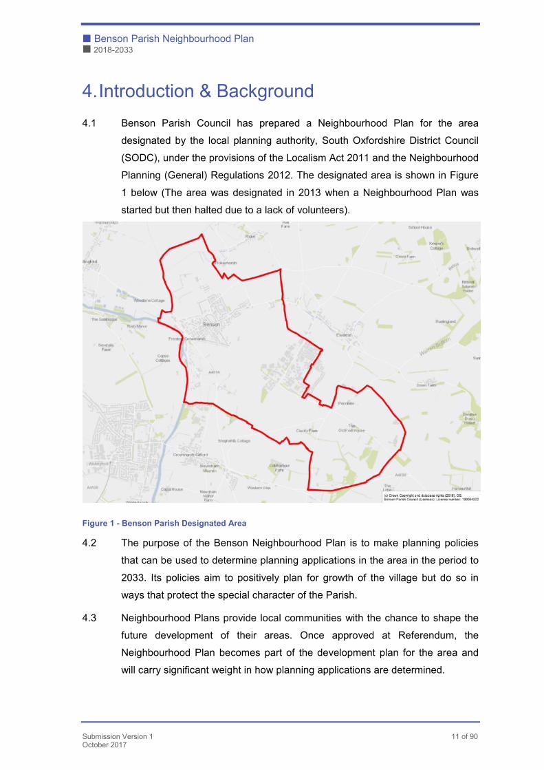
4. Introduction & Background
4.1 Benson Parish Council has prepared a Neighbourhood Plan for the area
designated by the local planning authority, South Oxfordshire District Council
(SODC), under the provisions of the Localism Act 2011 and the Neighbourhood
Planning (General) Regulations 2012. The designated area is shown in Figure
1 below (The area was designated in 2013 when a Neighbourhood Plan was
started but then halted due to a lack of volunteers).
Figure 1 - Benson Parish Designated Area
4.2 The purpose of the Benson Neighbourhood Plan is to make planning policies
that can be used to determine planning applications in the area in the period to
2033. Its policies aim to positively plan for growth of the village but do so in
ways that protect the special character of the Parish.
4.3 Neighbourhood Plans provide local communities with the chance to shape the
future development of their areas. Once approved at Referendum, the
Neighbourhood Plan becomes part of the development plan for the area and
will carry significant weight in how planning applications are determined.
Benson Parish Neighbourhood Plan �
2018-2033 �
12 of 90 Submission Version 1
October 2017
4.4 Neighbourhood Plans can therefore only carry land use policies that can be
used for this purpose. Other important issues of interest to the local community
that cannot be addressed in a Neighbourhood Plan should be pursued through
alternative means if not directly related to planning.
4.5 Although there is considerable scope for the local community to decide on its
planning policies, Neighbourhood Plans must meet some ‘basic conditions’.
These are:
� Is the Plan consistent with the National Planning Policy?
� Is the Plan consistent with local planning policy?
� Does the Plan promote the principles of sustainable development?
� Has the process of making the Plan met the requirements of the European
environmental standards?
4.6 In addition, the Parish Council must be able to show that it has properly
consulted local people and other relevant organisations during the process of
making its Neighbourhood Plans and has followed the 2012 Neighbourhood
Planning Regulations.
4.7 These requirements will be tested by an independent examiner once the
Neighbourhood Plan is finalised. If satisfied, the examiner will recommend the
Plan goes to a referendum of the local electorate. If a simple majority votes for
the Plan, then it becomes adopted as formal planning policy for the area.
The Pre-Submission Plan
4.8 The Pre-Submission Plan was submitted for consultation in March 2017. A total
of 256 comments were received from Statutory Bodies, Developers and local
residents. The Benson Neighbourhood Plan website contains background
information: www.bensonplan.org
4.9 The Parish Council received a Screening Opinion from SODC which
established the need for the Benson Neighbourhood Plan to be accompanied
by a Sustainability Appraisal (incorporating a Strategic Environmental
Assessment (SA/SEA)) under the Directives 42/2001 and the 2004
Environmental Assessment of Plans and Programmes Regulations.
� Benson Parish Neighbourhood Plan
� 2018-2033
Submission Version 1 13 of 90 October 2017
5. The Neighbourhood Area
5.1 Benson is located in the County of Oxfordshire and is approximately 3 miles
from Wallingford and 12 miles from Oxford. The population of Benson Parish is
currently 47541 people, inclusive of RAF Benson personnel. It has 1719
dwellings however, it should be noted that this figure includes RAF Benson
Service Family Accommodation which is not available to non-service
personnel. Therefore, for the purpose of Neighbourhood Planning, the accurate
figure for the number of dwellings in Benson is 1319.
None of the facilities within RAF Benson are available to non-service personnel
with the exception of the RAF Benson Primary School, which is open to non-
service children.
5.2 Benson was once known as Bensington and developed east of the River
Thames which once formed the boundary between British tribes of the Anglo-
Saxon era (fighting at Bensington is recorded in the Anglo-Saxon Chronicle).
5.3 Bensington was a Royal manor for over 800 years from the days of Offa the
Mercian, who built the first stone church in Benson, to 1628 when it was sold
by King Charles I. Prosperity came to Benson with the growth of the stage-
coach service from London to Oxford when Benson became an important stop
on this route. There are still a number of former coaching inns in the village.
5.4 In 1937 work began on the construction of RAF Benson on fields on the
outskirts of the village. During World War II it was home to the Photographic
Reconnaissance Unit and later the Queen’s Flight. It is now a front-line
helicopter support base within Joint Helicopter Command and is home to
Chinook and Puma helicopters as well as various Lodger units.
5.5 Benson is a rural community surrounded by agricultural land, with the
exception of RAF Benson which lies to the East of the village. There are limited
employment opportunities in the village with the majority of working people
commuting to their place of work.
5.6 The Parish Facilities include St Helen’s Church, Benson Church of England
primary school, the Mill Stream Day Centre, several shops, a Doctors Surgery,
two pubs and a petrol filling station. The Parish Council also maintains four play
1 2011 Census figure
Benson Parish Neighbourhood Plan �
2018-2033 �
14 of 90 Submission Version 1
October 2017
areas, two sets of allotments and a large recreation ground used for football,
general recreation and hosting community events.
5.7 The nearest train station is Cholsey, located approximately 5 miles from
Benson, and provides links to Oxford, Reading and London Paddington. The
X39/X40 provides a good bus service to Oxford and Reading and the 136
service provides a local service between RAF Benson and Cholsey via Benson
and Wallingford.
5.8 There are two conservation areas in the Parish. The historic core of Benson
extending to Littleworth Road, and another at the southern end of Preston
Crowmarsh. There are also 74 listed buildings in Benson. For further detail see
Section 7: Conservation and Heritage, and Appendices C Heritage and E
Character Assessment.
� Benson Parish Neighbourhood Plan
� 2018-2033
Submission Version 1 15 of 90 October 2017
6. Planning Policy Context
6.1 The Plan area lies within South Oxfordshire District in the County of
Oxfordshire.
6.2 The National Planning Policy Framework (NPPF) published by the Government
in 2012 is an important guide in the preparation of Local and Neighbourhood
Plans. The Benson Neighbourhood Plan must demonstrate that it is
consistent with the provisions of the NPPF. The following paragraphs of the
NPPF are particularly relevant to the Benson Neighbourhood Plan:
� Supporting a prosperous rural community (paragraph 28)
� Good Design (paragraph 58)
� Protecting healthy communities (paragraph 70)
� Protecting local green spaces (paragraph 76)
� Conserving and enhancing the natural environment (paragraph 109)
� Conserving and enhancing the historic environment (paragraph 126)
� Neighbourhood Planning (paragraph 185)
6.3 The development plan for the Parish currently comprises the South Oxfordshire
Core Strategy of December 2012 (covering a plan period to 2027) and a
number of saved policies of the South Oxfordshire Local Plan 2011, adopted in
January 2006 (covering the plan period to 2011). The emerging South
Oxfordshire Local Plan 2033, which is expected to be adopted in 2018, will
replace the Core Strategy and saved policies.
6.4 Although the Benson Neighbourhood Plan will be tested for general conformity
with the strategic policies of the adopted Core Strategy and Local Plan, the
imminence of the new Local Plan means the Benson Neighbourhood Plan
should consider the emerging policy direction and its reasoning and evidence.
6.5 The overall planning strategy for the District is to focus development on a new
strategic town, the existing main towns of Didcot, Henley and Wallingford and
the larger villages of the District whilst maintaining the rural character of the
open countryside that makes up the majority of the area. See Figure 2 below.
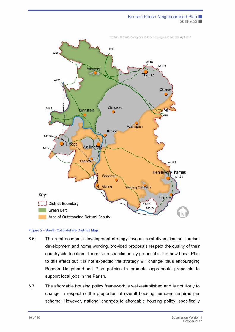
Benson Parish Neighbourhood Plan �
2018-2033 �
16 of 90 Submission Version 1
October 2017
Figure 2 - South Oxfordshire District Map
6.6 The rural economic development strategy favours rural diversification, tourism
development and home working, provided proposals respect the quality of their
countryside location. There is no specific policy proposal in the new Local Plan
to this effect but it is not expected the strategy will change, thus encouraging
Benson Neighbourhood Plan policies to promote appropriate proposals to
support local jobs in the Parish.
6.7 The affordable housing policy framework is well-established and is not likely to
change in respect of the proportion of overall housing numbers required per
scheme. However, national changes to affordable housing policy, specifically
� Benson Parish Neighbourhood Plan
� 2018-2033
Submission Version 1 17 of 90 October 2017
the inclusion of Starter Homes in its definition, are likely to significantly alter the
economics and therefore mix of tenure type that can be planned for through the
local planning system.
6.8 The indication from the Strategic Housing Market Assessment (SHMA) is that
Benson will be required to plan for an additional 383 dwellings in the period to
2033 (Core Strategy + 15% growth). In July 2016 the District Council Planning
Committee voted in favour of delegating authority to grant outline planning
permission to the Head of Planning for 241 dwellings on the site opposite
Littleworth Road, subject to the completion of a Section 106 agreement and
various conditions.
6.9 This followed an earlier Appeal hearing which found in favour of the 159
dwellings on the same site at Littleworth Road. This figure was then increased
to 187 via an amended planning application. Therefore, a total of 428 dwellings
are being developed on the site. Given the timing of the approval of the second
phase these additional houses count as a commitment rather than as additional
growth. Nevertheless a policy is included in the Plan to control the development
of this site in the event that revised or new applications are submitted.
6.10 The Benson Neighbourhood Plan Team recognise the 15-year period of the
Plan and the facilities that Benson offers as a larger village. The Benson
Neighbourhood Plan will therefore be recommending up to an additional 324
dwellings in addition to the 241 already approved. This reflects a balanced
approach that seeks to facilitate new residential development to include the
construction of a Relief Road. The road will provide capacity for the new
developments themselves and in doing so will bring significant relief to the
historic street network as the B4009 runs through the village in an east-west
direction. This approach to the future development of the Plan area is set out in
the Strategic Policies section of this document. Policies NP 2-5 respectively set
out the details of the sites concerned and the development principles that will be
applied to each in turn.
6.11 The Core Strategy requires the mix of housing types to reflect local
circumstances, which is expected to remain a requirement as this is consistent
with the NPPF.
Benson Parish Neighbourhood Plan �
2018-2033 �
18 of 90 Submission Version 1
October 2017
6.12 The Core Strategy and saved polices seek to prevent the unnecessary loss of
valued community facilities. This provides an opportunity for the Benson
Neighbourhood Plan to identify those community facilities in the Parish that
warrant protection from these policies.
6.13 There is a comprehensive framework of landscape protection policies that are
relevant to the Plan area, given its proximity to the AONB and River Thames.
The framework allows for appropriate development but reinforces the
importance of ensuring all development proposals respect the landscape
character. The policies will help inform site selection and other policies of the
Benson Neighbourhood Plan.
6.14 Although these policies now repeat national policy guidance, and so are
therefore unlikely to be included in the new Local Plan in these forms, they
reinforce the importance of proposals having full regard to heritage assets,
whether formerly designated or not. The Parish contains a significant number
of listed buildings as well as two Conservation Areas. These heritage assets
will very much shape the Design and other policies of the Benson
Neighbourhood Plan. The Benson Neighbourhood Plan may also define the
special character of the local Conservation Areas and design specific guidance
that is appropriate to this character.
6.15 The local policy framework contains a range of generic design and
development management policies to be applied to all types of development
proposals across the District. There is the opportunity for the Benson
Neighbourhood Plan to refine this framework so the guidance is specific to the
Parish. This more specific Plan area guidance will have weight in decision
making.
6.16 The framework contains a variety of policies promoting the multi-functional
benefits of green infrastructure assets and requiring their protection, achieving
no net loss of biodiversity. Such assets are especially important in defining the
character and in the functioning of the village and wider Parish. The Benson
Neighbourhood Plan will bring forward specific policy proposals to protect and
improve existing green infrastructure assets and to create new assets through
development proposals.
� Benson Parish Neighbourhood Plan
� 2018-2033
Submission Version 1 19 of 90 October 2017
7. Community Views on Planning
7.1 The decision to prepare a Neighbourhood Plan was taken by Benson Parish
Council in January 2016 following a public meeting held in the Parish Hall on
the 15th January 2016. A Steering Group for the Neighbourhood Plan, made up
of residents and 3 Parish Councillors, was formed in February 2016.
7.2 A consultant, recommended and funded by SODC, was appointed in January
2016. With the assistance of the consultant, the Benson Neighbourhood Plan
was developed over a period of 12 months, rather than the usual 2 or 3 years.
7.3 The Parish Council submitted an application to South Oxfordshire District
Council to designate the area covered by the Benson Neighbourhood Plan in
the first quarter of 2016. The agreed designated area is the same as the Parish
boundary.
7.4 A Neighbourhood Plan is a community project and must derive its authority and
policies from the community. Communication, consultation and feedback have
played a major part in the development of our Plan. The consultation process
included:
� The Neighbourhood Plan Steering Group meeting at least monthly;
� Minutes of the meetings being posted on the Neighbourhood Plan website;
� Updates were provided in the Benson Bulletin (village magazine) and
Neighbourhood Plan Facebook page;
� One to one meetings with land owners and developers;
� Updates to the Parish Council;
� Drop-In sessions for villagers throughout the development of the Plan;
� Attendance at Village Events (e.g. Benson Village Fayre);
� Regular email updates to villagers;
� Village meetings open to all residents of the village
As the Neighbourhood Plan progressed, the frequency of meetings has
increased in order to gauge community response to site allocations and
policies.
7.5 In May 2016 an independent Housing Needs Survey was commissioned by the
Neighbourhood Plan Team and undertaken by Community First Oxfordshire.
Benson Parish Neighbourhood Plan �
2018-2033 �
20 of 90 Submission Version 1
October 2017
The Housing Needs Survey allowed respondents to answer questions designed
to help establish priorities for the Plan and allowed them to make general
comments. The results were independently collated and made available to the
Neighbourhood Plan Team and Parish Council. A total of 595 questionnaires
were returned, representing a 42.4% response rate.
7.6 In order to inform development of the Plan a traffic study was carried out by the
Transport Team of the Neighbourhood Plan with traffic data also being
obtained from Oxfordshire County Council Highways. The data was collected
from various points within the village and used to assess the impact of
developments on the current road infrastructure within the village and known
traffic ‘pinch points’.
7.7 A heritage study was undertaken in collaboration with members of the
Bensington Society History Group with results set out in Appendix C. It looks
at key areas of local heritage significance and identifies buildings within
Benson and Preston Crowmarsh which are not designated as listed buildings
but are of local note. The results of this study were also used, along with
character assessments carried out by members of the Design Team, to inform
the Design Policy and the Design Statement for Benson.
7.8 An independent planning consultant, Andrew Ashcroft, recommended by
SODC was appointed to help with policy development. In addition RCOH Ltd
was appointed to undertake the Strategic Environmental Assessment (SEA)..
7.9 The Benson Neighbourhood Plan and its supporting evidence is available on
the Benson Neighbourhood Plan website and Parish Council website. Links are
also provided on the Neighbourhood Plan Facebook page. To allow for access
to those without the Internet, paper copies have been made available at the
Parish Office and Library.
� Benson Parish Neighbourhood Plan
� 2018-2033
Submission Version 1 21 of 90 October 2017
8. Vision and Objectives
Vision
8.1 Benson will accommodate the level of growth required to meet our local
housing needs, while conserving and enhancing its heritage and protecting its
rural setting beneath the Chiltern Hills and alongside the River Thames. Our
Neighbourhood Plan will encourage a modern, thriving and self-confident
village centre, together with the facilities and infrastructure necessary to meet
the economic, social and environmental needs of the community. As part of
this, the planning process will promote sensitive development that integrates
well with the rest of the village and design standards that ensure Benson
retains its distinctive character.
Objectives
8.2 In order to achieve the above Vision a number of objectives have been
identified as follows:
� Provide sufficient housing to meet local needs;
� Cater for growth in a manner that maintains the distinct and separate
character of the village;
� Cater for growth in a manner that conserves and enhances heritage within the
Neighbourhood Plan area;
� Cater for growth in a manner which respects Benson’s setting in the rural
landscape and its close association with the River Thames;
� Ensure that Benson has a modern, vibrant village centre;
� Ensure there are adequate facilities to serve our growing local population;
� Ensure the sustainability of economic activity in the Neighbourhood Plan
area;
� Safeguard and enhance existing green infrastructure and secure the provision
of additional green space connected to the wider countryside;
� Ensure that new development is sited, planned and executed in a way that
takes account of climate change and other changes in the natural
environment;
Benson Parish Neighbourhood Plan �
2018-2033 �
22 of 90 Submission Version 1
October 2017
� Ensure that new development contributes towards the free and safe flow of
traffic and has a minimum impact on the existing highway infrastructure;
� Encourage walking and cycling to get around the village by providing a
network of safe pedestrian and cyclist routes, in particular to the centre;
� Encourage sustainable modes of transport by all means available.
� Benson Parish Neighbourhood Plan
� 2018-2033
Submission Version 1 23 of 90 October 2017
9. Land Use Policies
Introduction
9.1 Prior to development of the Neighbourhood Plan, Phase 1 of site BEN1 at
Littleworth Road was approved for development following an Appeal Inquiry (See
SODC Planning Application P14/S0673/O). The original outline application was
for 159 dwellings however this was subsequently increased to 187 dwellings
following the submission of an amended planning application, The 187 dwellings
do not count towards the housing allocation target for Benson as the application
was approved prior to March 2016.
Housing Allocation Policy
9.2 An assessment of each potential development site was undertaken as part of
the Neighbourhood Plan development in order to objectively assess the 10
sites put forward. The sites were assessed against the following criteria:
� Landscape Character and setting
� Green Infrastructure
� Heritage
� Core Facilities
� Transport
� Other
The Sites Assessment report can be found at Appendix A.
9.3 Following the assessments, three of these sites (BEN1 Phase 2, BEN2,
BEN3/4) are allocated for housing development in this Neighbourhood Plan.
These three allocated sites will together deliver 565 additional homes.
9.4 Phase 1 of site BEN1 already has the benefit of planning permission and that,
taken together with sites BEN1 Phase 2, BEN2, and BEN3/4, would be able to
deliver a Relief Road to the north of the village, linking the B4009 on the east side
directly with the A4074 or B4009 on the west. This is the only feasible route for
such a Relief Road, bounded as the village is by RAF Benson on the south and
Benson Parish Neighbourhood Plan �
2018-2033 �
24 of 90 Submission Version 1
October 2017
east and by the A4074 and River Thames to the south and west (see the
Transport Assessment at Appendix F). The Relief Road would provide
appropriate transport capacity for the new homes, provide connectivity for the
allocated sites to the services and facilities in the village and also provide relief to
the existing road network within the village, thereby reducing congestion and
traffic flow through the congested village centre. The proposals would therefore
provide sustainable development.
9.5 A small-scale site at The Meer (BEN10) has been identified as a possible site for
100% affordable housing. Parts of two further sites are allocated for provision of
communal facilities, one for a burial ground (BEN7) and one for a green space
nature area with car parking (BEN9 - Materials Store).
9.6 The remaining sites put forward for development are not allocated for housing for
the reasons set out in the Site Assessment Report (Appendix A). The selected
sites represent sustainable development and further less sustainable sites are
not required as local housing requirements will be met by the allocated sites.
They would place additional load on infrastructure without securing the delivery of
the much needed Relief road, and could prejudice delivery of that road by
consuming school places for which there is limited additional capacity.
Development levels beyond that proposed in this Neighbourhood Plan would
represent excessive and unsustainable change to the village in both
environmental and social terms.
9.7 The community recognises that the development of the various sites will take
place throughout the Plan period. Nevertheless, each housing allocation sets out
a requirement that the site’s contribution towards the development of the Relief
Road is completed during the construction period.
� Benson Parish Neighbourhood Plan
� 2018-2033
Submission Version 1 25 of 90 October 2017
Site Allocations
9.8 The Plan proposes the development of three sites throughout the Plan period.
These allocations sit at the very heart of the Plan. All of the development sites
are fundamentally associated with the construction of the proposed Relief
Road. The fourth site proposes the allocation of a burial ground.
NP 1
New residential development in the neighbourhood will be focussed in the three proposed housing allocations (Policies NP2 – NP4). The three large scale developments identified in Policies NP2 – NP4 will be supported where they:
• Together safeguard land for the whole route of a viable Relief Road, to a specification agreed by OCC Highways, to the north of the village that connects the B4009 at or near Braze Lane in the east to the A4074 or B4009 at or near Elm Bridge roundabout in the west; and
• Provide for the construction of the Relief Road to a single consistent specification across their site and connecting with neighbouring sites; and
• Contribute proportionally to the financing and connecting of the Relief road into the B4009 at or near Braze Lane in the east and into the A4074/B4009 at or near Elm Bridge roundabout to the west; and
• Conform to the other policies in this Plan.
In-fill development, which reflects the scale and character of the village, will be supported within the built-up area of Benson where it accords with the policies of this Plan, with the emerging South Oxfordshire Development Plan, and in particular with those policies relating to rural areas and to the status of Preston Crowmarsh as an ‘Other Village’;
Proposals for development outside of the built-up area of Benson or outside of the sites identified in Policies NP2 – NP4 will only be supported if they are consistent with local development plan policies.
Benson Parish Neighbourhood Plan �
2018-2033 �
26 of 90 Submission Version 1
October 2017
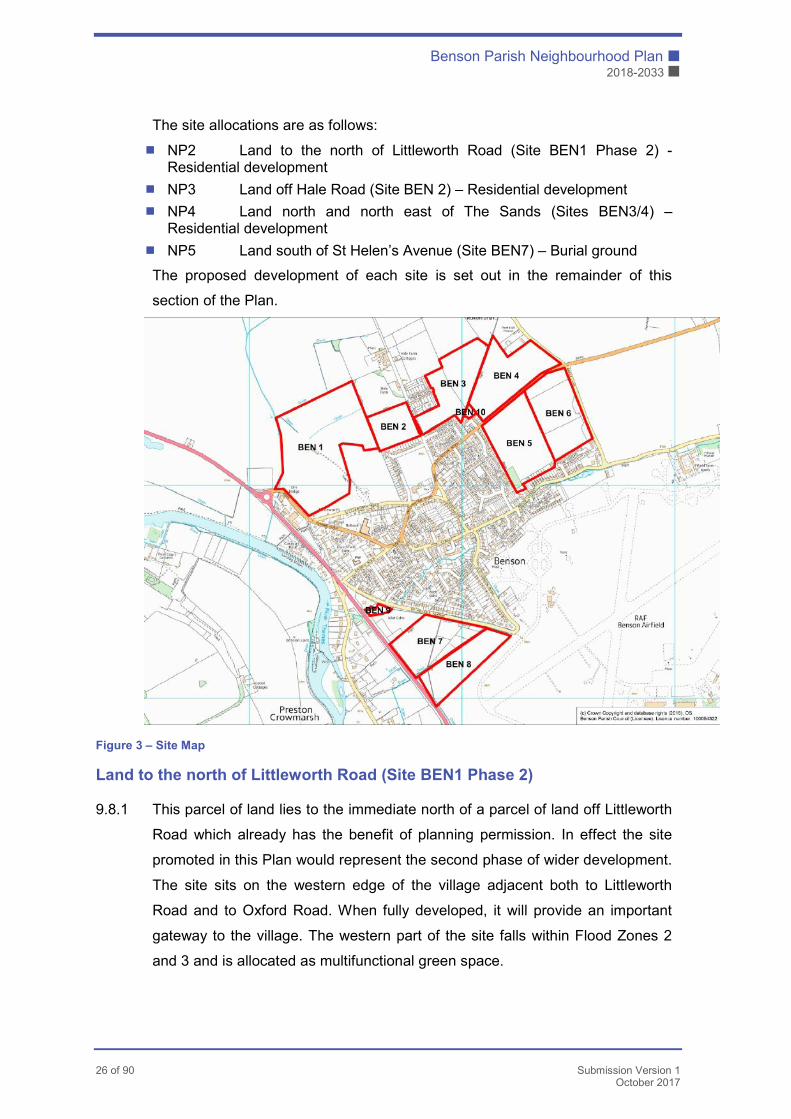
The site allocations are as follows:
� NP2 Land to the north of Littleworth Road (Site BEN1 Phase 2) - Residential development
� NP3 Land off Hale Road (Site BEN 2) – Residential development
� NP4 Land north and north east of The Sands (Sites BEN3/4) – Residential development
� NP5 Land south of St Helen’s Avenue (Site BEN7) – Burial ground
The proposed development of each site is set out in the remainder of this
section of the Plan.
Figure 3 – Site Map
Land to the north of Littleworth Road (Site BEN1 Phase 2)
9.8.1 This parcel of land lies to the immediate north of a parcel of land off Littleworth
Road which already has the benefit of planning permission. In effect the site
promoted in this Plan would represent the second phase of wider development.
The site sits on the western edge of the village adjacent both to Littleworth
Road and to Oxford Road. When fully developed, it will provide an important
gateway to the village. The western part of the site falls within Flood Zones 2
and 3 and is allocated as multifunctional green space.
� Benson Parish Neighbourhood Plan
� 2018-2033
Submission Version 1 27 of 90 October 2017
9.8.2 The proposed Relief Road for the village would run through this site and is
proposed to link into the A4074 in the vicinity of Elm Bridge roundabout.
9.8.3 Other policies in this Plan set out the need for the delivery of recreational open
space on new residential developments. This principle is applied directly to this
site. In addition, this site has been identified for the provision of a Youth Facility
Building, Fitness Trail, a Skate Park and other green infrastructure including
space to meet wildlife needs (as set out in Policy NP26 of this Plan).
9.8.4 This and other sites will increase the demand on the usage of the GP surgery
in the village. Policy NP18 addresses this matter in a strategic way and
allocates CIL funding for the expansion of the Surgery. The development of this
site will be expected to contribute towards the delivery of this new facility
9.8.5 This site has the potential to offer one of the highest yields of new homes of the
allocated sites proposed in this Plan. Its approximate yield is anticipated to be
240 dwellings. Its development in accordance with the principles set out in this
policy will contribute much to sustainable development – in particular it will
bring an economic dimension through the houses themselves, it will have a
social dimension through its community and open spaces contributions and its
part in delivering a Relief Road will have significant environmental benefits
9.8.6 The land to the west of the Littleworth Road site is Flood Zone 2 and 3, and in
proposals seeking outline consent for development, the developer proposed
the creation of a 5ha nature park/reserve on this section of land. This plan
formally allocates that land for this purpose, ensuring that policy NP27, which
requires a net positive gain for biodiversity, is met. Habitat creation on the
reserve will be taken forward to achieve the locally specific priorities set out in
Benson's People and Nature Strategy. This significant new green space for the
village will be have footpaths aimed at encouraging public access/recreational
use including as a fitness trail. It will also connect via margins around the
development with the new green buffer proposed to the north of land off Hale
Road (BEN 2), land to the north and north east of Sands Way (BEN3) and land
to the north of The Sands B4009 (BEN4).
9.8.7 There is an opportunity to enhance connectivity by creating a walking/cycling
route between the new 5ha nature area/reserve and Warwick Spinney (a
Benson community-owned green asset immediately adjacent to the western
parish boundary). The Spinney is managed for its wildlife interest (as agreed
Benson Parish Neighbourhood Plan �
2018-2033 �
28 of 90 Submission Version 1
October 2017
with the Charities Commission) and the provision of green space for dog
walking, but at present there is no safe pedestrian access from the village. A
new connection would address this shortcoming. A footbridge will be provided
crossing Berrick Stream and Lady Brook from the nature area, to link up with
Footpath 392/17 (WB17) which runs north towards Warborough and thus
create access to Warwick Spinney. The access involves crossing a small area
of farmland, currently not in cultivation, upon which the landowner is supportive
of creating a permissive path to facilitate this measure.
9.8.8 This policy identifies a series of obligations on the land owner and/or developer
concerned. These obligations reflect the overall strategy of the Plan and its
ambition to secure high-quality, sustainable development in Benson. There are
two principal obligations. The first is for the developer to construct the relevant
section of the relief road as part of the development of the site. The second is
for the provision of affordable housing to development plan standards.
9.8.9 The Parish Council recognises that the costs of delivering the relief road may
be beyond those normally associated with the development of a housing site of
this scale. It also acknowledges that viability is a key consideration in national
planning policy. Nevertheless, any proposals to reduce the scale of
contributions associated with this site will only be considered in the event that
they are supported by a full justification underpinned by robust evidence and a
clear reasoning for the proposed reduced contributions. Such matters should
be included with the wider package of information submitted with the eventual
planning applications.
� Benson Parish Neighbourhood Plan
� 2018-2033
Submission Version 1 29 of 90 October 2017
NP 2
Proposals for the residential development of land off Littleworth Road as shown on the proposals map will be supported subject to delivery of a comprehensive proposal addressing the following criteria:
• Provision of a Relief Road providing a connection to the A4074 or B4009 and to the land off Hale Road (NP3);
• The Relief road should be fully constructed and adopted before the occupation of more than 50% of houses on the site;
• Provision of open space and allotments and associated parking and access as set out in Policy NP21, NP22 and NP23 including the provision of a Youth Facilities building with appropriate parking, Skate Park and Fitness Trail;
• A housing mix to meet local needs as identified in the Community Questionnaire Report (Housing Needs Survey);
• Delivery of 40% of the total housing numbers to be Affordable Housing;
• Provision of appropriate CIL contributions towards the capital costs of the Doctors’ surgery expansion;
• A (5 ha) nature reserve (as proposed in the P16/S1139/O planning application) must be provided on the area falling within Flood Zone 2 and 3. Detailed design of the nature area will reflect the locally specific aims and ambitions of Benson’s strategy for People and Nature. The nature area will connect with the green buffer to be created along the edge of development on land off Hale Road (BEN2), land to the north and north east of The Sands (BEN4) and;
• A new connection for pedestrians must be provided from the nature area opposite Warwick Spinney via a footbridge across ‘Berrick Stream and Ladybrook’ to the public right of way Footpath 392/17 (WB17) running north towards Warborough;
• Development proposals must incorporate measures that avoid the risk of causing any deterioration in the ecological status of ‘Berrick Stream and Ladybrook’ (also known as Elm Brook).
• As far as possible, existing hedges and trees should be retained, and where removal is necessary, compensation for the loss of the biodiversity asset must be incorporated into plans.
Benson Parish Neighbourhood Plan �
2018-2033 �
30 of 90 Submission Version 1
October 2017
Land off Hale Road (Site BEN2)
9.8.10 This site is located adjacent to Hale Road and to the north of Sunnyside. It is
the smallest of the strategic housing allocations proposed in the Plan. It is
rectangular in shape and sits to the immediate west of Hale Road. It is one of
four allocated sites both to provide new housing in the village to meet strategic
housing needs and to provide a Relief Road to the village. The Relief Road
provision will be fundamental to any approval. Its junction with Hale Road will
need to be implemented in accordance with Highway Authority guidance. It is
anticipated that the site will yield approximately 80 dwellings.
9.8.11 During discussions with the developer promoting this site they have advised
they typically build smaller housing units (2 or 3-bedroom units) which aligns
well with the Community Questionnaire Report which identified a desire of 33%
current residents to downsize and a need for some bungalow accommodation.
9.8.12 Play space on the site will be required and in a proportionate fashion to number
of dwellings. This reflects the need to secure a sustainable development in its
own right and the stretched nature of existing facilities in the village. Given the
limited nature of this allocation and its need to accommodate both the Relief
Road itself and its junction arrangements with Hale Road there may be merit in
providing the appropriate amount of open space off site.
9.8.13 Residential development should allow for views out to Vale, Chiltern Hills and
North Wessex Downs (Wittenham Clumps). It is important that new residential
development reflects its position within the wider landscape. This matter is
addressed more generally in policy NP31 of this Plan.
9.8.14 This and other sites will increase the demand on the usage of the GP surgery
in the village. Policy NP18 addresses this matter in a strategic way and
allocates CIL funding for expansion of the Surgery. The development of this
site will be expected to contribute towards the expansion of this facility.
9.8.15 The existing hedge to the north of the site is important in its own right. It will
also serve to provide an important buffer between the new housing and the
open countryside to the immediate north. Policy NP3 proposes that it is
reinforced with a landscape buffer incorporating public access to its immediate
south within the development site.
� Benson Parish Neighbourhood Plan
� 2018-2033
Submission Version 1 31 of 90 October 2017
9.8.16 Development of the site will be expected to respect and safeguard the
residential amenities of the properties to the immediate south of the site (in
Sunnyside).
9.8.17 This policy identifies a series of obligations on the land owner and/or developer
concerned. These obligations reflect the overall strategy of the Plan and its
ambition to secure high-quality, sustainable development in Benson. There are
two principal obligations. The first is for the developer to construct the relevant
section of the relief road as part of the development of the site. The second is
for the provision of affordable housing to development plan standards.
9.8.18 The Parish Council recognises that the costs of delivering the relief road may
be beyond those normally associated with the development of a housing site of
this scale. It also acknowledges that viability is a key consideration in national
planning policy. Nevertheless, any proposals to reduce the scale of
contributions associated with this site will only be considered in the event that
they are supported by a full justification underpinned by robust evidence and a
clear reasoning for the proposed reduced contributions. Such matters should
be included with the wider package of information submitted with the eventual
planning applications.

Benson Parish Neighbourhood Plan �
2018-2033 �
32 of 90 Submission Version 1
October 2017
NP3
Proposals for residential development of land off Hale Road as shown on the proposals map will be supported subject to delivery of a comprehensive proposal which addresses the following criteria:
� Provision of a Relief Road connecting land off Littleworth Road (NP2) to land north and north-east of The Sands (NP4);
� The Relief Road should be fully constructed and adopted before occupation of more than 50% of the total houses on the site;
� Provision of open space and allotments plus associated parking and access as set out in Policy NP21;
� The housing mix for this site should predominantly focus on 2 and 3-bedroom units with some bungalow provision on site;
� Delivery of 40% of the total housing numbers to be Affordable Housing;
� Provision of offsite contributions to be applied to the improvement of the existing play area at Sunnyside for the required amount of open space for the housing development to SODC standards in place at the time any application is determined;
� Provision of appropriate CIL contributions towards capital costs of expansion of the Doctors’ Surgery;
� Delivery of a layout that safeguards residential amenities of the properties to the immediate south of the site in Sunnyside;
� Retention of the existing hedge forming the northern boundary of the site and its consolidation with a 3metre landscape buffer to its immediate south.
� Benson Parish Neighbourhood Plan
� 2018-2033
Submission Version 1 33 of 90 October 2017
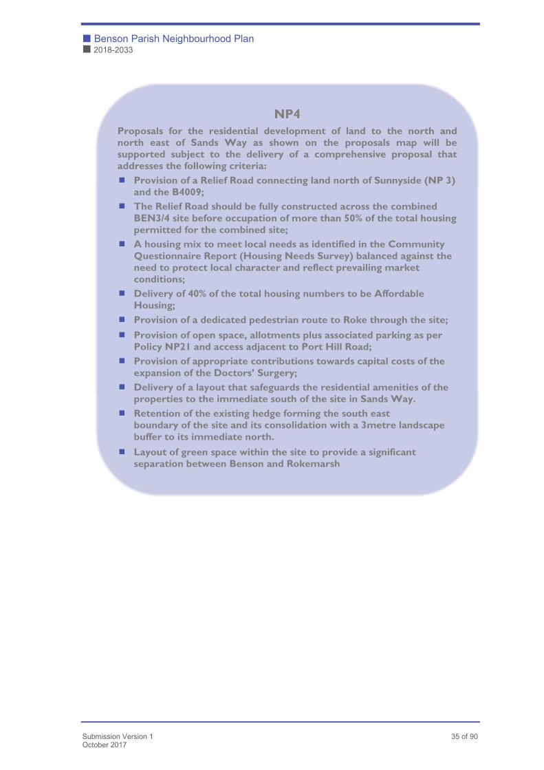
Land North and North East of The Sands (Sites BEN 3 / BEN4)
9.8.19 This site is located to the north and north east of The Sands. It is one of
three allocated sites both to provide new housing in the village to meet
strategic housing needs and to provide a Relief Road to the village. The Relief
Road provision will be fundamental to any approval. Its junctions with Hale
Road and the B4009 are to be implemented in accordance with Highway
Authority guidance.
9.8.20 It is anticipated that the site will yield approximately 240 dwellings.
9.8.21 A green/landscape buffer will need to be provided such that the settlement of
Rokemarsh remains distinct and separate from Benson. The buffer must be
designed such that it acts as a wildlife corridor and offers a safe route for
pedestrians and cyclists, in particular providing improved access to the Local
Green Space at Sunnyside
9.8.22 Residential development should allow for views out to Vale, Chiltern Hills and
North Wessex Downs (Wittenham Clumps). It is important that new residential
development reflects its position within the wider landscape. This matter is
addressed more generally in policy NP31 of this Plan.
9.8.23 A well-used public footpath cuts through the centre of the site. A pedestrian
route to Roke must be maintained, but with enhancements (widening, planting)
such that the routes performs as a wildlife corridor and as a dual-purpose
footpath/cycleway. The policy requires the provision of allotments with parking
and vehicle delivery access (at northern edge next to Port Hill). This is an
important factor which reflects community feedback.
9.8.24 This and other sites will increase the demand on the usage of the GP surgery
in the village. Policy NP18 addresses this matter in a strategic way and
allocates CIL funding for expansion of the Doctors Surgery. The development
of this site will be expected to contribute towards the expansion of this facility.
9.8.25 There is a shortage of allotments in the Plan area with uptake consistently
running at over 90% with, at times, a waiting list in operation. Play space on the
site will be required and in a proportionate fashion to number of dwellings. This
reflects the need to secure a sustainable development in its own right and the
stretched nature of existing facilities in the village.
Benson Parish Neighbourhood Plan �
2018-2033 �
34 of 90 Submission Version 1
October 2017
9.8.26 The development of the site will be expected to respect and safeguard the
residential amenities of the properties to the immediate south of the site (in
Sands Way).
9.8.27 The existing hedge to the south east of the site which forms its boundary with
The Sands (B4009) is important in its own right. It will also serve to provide an
important buffer between the new housing and the open countryside to the
immediate south. Policy NP4 proposes that it is reinforced with a landscape
buffer to its immediate south within the development site.
9.8.28 This policy identifies a series of obligations on the land owner and/or developer
concerned. These obligations reflect the overall strategy of the Plan and its
ambition to secure high-quality, sustainable development in Benson. There are
two principal obligations. The first is for the developer to construct the relevant
section of the relief road as part of the development of the site. The second is
for the provision of affordable housing to development plan standards.
9.8.29 The Parish Council recognises that the costs of delivering the relief road may be
beyond those normally associated with the development of a housing site of this
scale. It also acknowledges that viability is a key consideration in national
planning policy. Nevertheless, any proposals to reduce the scale of
contributions associated with this site will only be considered in the event that
they are supported by a full justification underpinned by robust evidence and a
clear reasoning for the proposed reduced contributions. Such matters should be
included with the wider package of information submitted with the eventual
planning applications.
� Benson Parish Neighbourhood Plan
� 2018-2033
Submission Version 1 35 of 90 October 2017
NP4
Proposals for the residential development of land to the north and north east of Sands Way as shown on the proposals map will be supported subject to the delivery of a comprehensive proposal that addresses the following criteria:
� Provision of a Relief Road connecting land north of Sunnyside (NP 3) and the B4009;
� The Relief Road should be fully constructed across the combined BEN3/4 site before occupation of more than 50% of the total housing permitted for the combined site;
� A housing mix to meet local needs as identified in the Community Questionnaire Report (Housing Needs Survey) balanced against the need to protect local character and reflect prevailing market conditions;
� Delivery of 40% of the total housing numbers to be Affordable Housing;
� Provision of a dedicated pedestrian route to Roke through the site;
� Provision of open space, allotments plus associated parking as per Policy NP21 and access adjacent to Port Hill Road;
� Provision of appropriate contributions towards capital costs of the expansion of the Doctors’ Surgery;
� Delivery of a layout that safeguards the residential amenities of the properties to the immediate south of the site in Sands Way.
� Retention of the existing hedge forming the south east boundary of the site and its consolidation with a 3metre landscape buffer to its immediate north.
� Layout of green space within the site to provide a significant separation between Benson and Rokemarsh
Benson Parish Neighbourhood Plan �
2018-2033 �
36 of 90 Submission Version 1
October 2017
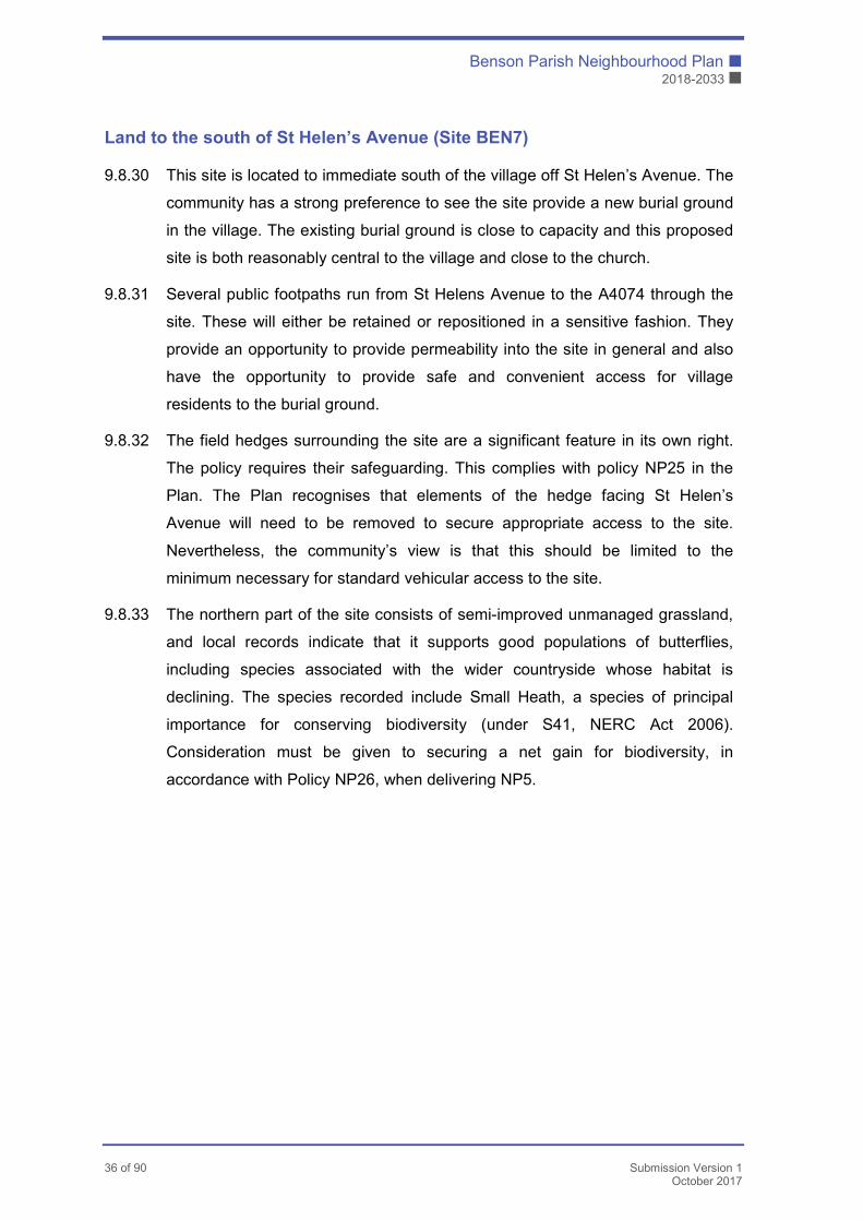
Land to the south of St Helen’s Avenue (Site BEN7)
9.8.30 This site is located to immediate south of the village off St Helen’s Avenue. The
community has a strong preference to see the site provide a new burial ground
in the village. The existing burial ground is close to capacity and this proposed
site is both reasonably central to the village and close to the church.
9.8.31 Several public footpaths run from St Helens Avenue to the A4074 through the
site. These will either be retained or repositioned in a sensitive fashion. They
provide an opportunity to provide permeability into the site in general and also
have the opportunity to provide safe and convenient access for village
residents to the burial ground.
9.8.32 The field hedges surrounding the site are a significant feature in its own right.
The policy requires their safeguarding. This complies with policy NP25 in the
Plan. The Plan recognises that elements of the hedge facing St Helen’s
Avenue will need to be removed to secure appropriate access to the site.
Nevertheless, the community’s view is that this should be limited to the
minimum necessary for standard vehicular access to the site.
9.8.33 The northern part of the site consists of semi-improved unmanaged grassland,
and local records indicate that it supports good populations of butterflies,
including species associated with the wider countryside whose habitat is
declining. The species recorded include Small Heath, a species of principal
importance for conserving biodiversity (under S41, NERC Act 2006).
Consideration must be given to securing a net gain for biodiversity, in
accordance with Policy NP26, when delivering NP5.

� Benson Parish Neighbourhood Plan
� 2018-2033
Submission Version 1 37 of 90 October 2017
NP5
Proposals for the development of a burial ground, subject to delivery of a comprehensive proposal addressing the following criteria:
� Provision of a burial ground of a minimum of approximately 0.25 hectares and associated parking and access adjacent off St Helen’s Road;
� Retention or the appropriate repositioning of the public footpaths that run through the site from St Helen’s Avenue to the A4074;
� Retention of the existing hedges surrounding the site and with any removal along St Helen’s Avenue limited to the minimum necessary for standard vehicular access to the site;

Benson Parish Neighbourhood Plan �
2018-2033 �
38 of 90 Submission Version 1
October 2017
10. Conservation and Heritage2
10.1 This section summarises the principles that drive the following policies. More
detailed information regarding the historic character and development of the
village is to be found in Appendix E Character Assessment. More detailed
information on heritage assets within the Plan Area is to be found in Appendix
C: Heritage Study. Appendix E Character Assessment includes a Schedule of
Buildings of Local Heritage note that has been compiled for the Plan.
10.2 Part of the vision for Benson is that development will respect its history. The
Benson Neighbourhood Plan Survey indicates that historic buildings are highly
valued by the community for their attractive traditional appearance, with
distinctive use of red and blue-grey brickwork, flint and chalky stone3. There is
a very strong interest in local history. This recognises the way in which historic
farmhouses and cottages tell of the original agricultural livelihood of the village,
and the (former) inns, large houses and shops of the 18th-19th century tell of
prosperity in the coaching era. The history of the village is also evident in the
surviving relationships with the fields, the brook and the River Thames and in
the evolution of the winding road layout, diverted first around bogs and then
around the airfield. The war memorial is an important focus for remembrance
ceremonies shared by the village and RAF communities.
10.3 Earlier history is preserved in place names and in the records of archaeological
discovery, and it is evident that the river gravels were particularly attractive to
early settlers. Finds are widespread, but there is particularly significant
evidence of a Neolithic cursus and other Prehistoric enclosures below the
airfield, and of Prehistoric and Early Saxon settlement at Saxon Close, the
latter likely to have been associated with Benson’s known importance as a
Saxon royal villa. Investigations carried out in connection with recent
applications for development continue to demonstrate the frequent incidence of
Prehistoric, Roman, Saxon and medieval settlement within and around the
perimeter of the present village.
2 See Appendix C Heritage Study for details of the four local history publications by The Bensington Society 3 See: The Benson Neighbourhood Plan Community Questionnaire Report 2016 at Appendix D. Q 26 asked
whether there anything that respondents wished to highlight as particularly distinctive or valuable about
the existing built environment of Benson. 140 respondents raised 178 themes, of which 139 related to the
historic village character and its traditional building materials.

� Benson Parish Neighbourhood Plan
� 2018-2033
Submission Version 1 39 of 90 October 2017
10.4 Consultation4 makes clear that there is strong support for policies to ensure
that such heritage is preserved to allow future understanding and enjoyment,
and that development is sensitive to its significance.
10.5 The plan area has 74 listed buildings, and both Benson and Preston
Crowmarsh have conservation areas. The following policies take account of
the statutory obligation to preserve and enhance these assets, as set out in
national and local policy. The formal designations do not, however, fully
capture the historic character of the long linear settlements extending beyond
the conservation areas, and the current appraisals do not elaborate on
relationships with the fields, river or brook. It is considered that these matters
should be taken into better account.
10.6 Historic England’s response to the SEA screening options in May/June 2016
expressed concern regarding the impact of development at Littleworth Road on
the character of the Conservation Area and called for suitably detailed and
robust policies to identify how development should respond to this key
consideration as set out within paragraph 58 of the NPPF. As Phase 1 of this
development is already approved such policies will not be relevant. Any re-
design or new proposals affecting the Conservation Area will, however, be
subject to the design principles set out in the Design Statement.
10.7 Many historic buildings along Brook Street, Littleworth Road and elsewhere are
not listed. Nevertheless, they are valued as having local interest because of
their traditional construction and historic interest. While there is as yet no
formal local list there is a desire to ensure that the contribution of such
buildings is recognised and respected, with significant buildings retained and
only appropriate development permitted between.
10.8 No archaeological assets in the plan area are Scheduled Ancient Monuments,
and protection relies on desk-based assessment as required by national policy,
with field evaluation where required. On the basis of past and emerging
evidence it is considered that there is high potential for finds of archaeological
significance, and that it is highly likely that field evaluation will be critical in
informing both proposals and the determination of applications. Furthermore,
Historic England have noted that the public benefit of development may not
4 Draft policies displayed at “drop-in” sessions held on 10th and 11th June 2016 were strongly supported. See account of this session within the Consultation Statement.
Benson Parish Neighbourhood Plan �
2018-2033 �
40 of 90 Submission Version 1
October 2017
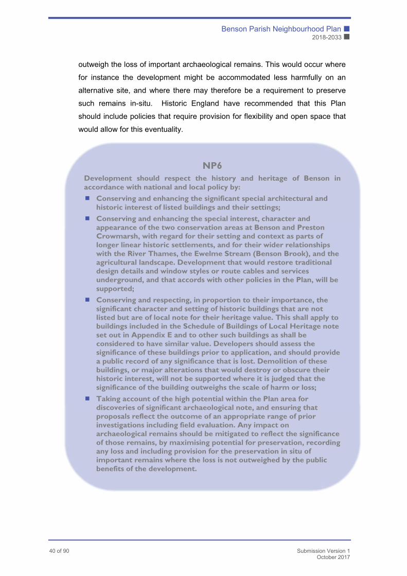
outweigh the loss of important archaeological remains. This would occur where
for instance the development might be accommodated less harmfully on an
alternative site, and where there may therefore be a requirement to preserve
such remains in-situ. Historic England have recommended that this Plan
should include policies that require provision for flexibility and open space that
would allow for this eventuality.
NP6
Development should respect the history and heritage of Benson in accordance with national and local policy by:
� Conserving and enhancing the significant special architectural and historic interest of listed buildings and their settings;
� Conserving and enhancing the special interest, character and appearance of the two conservation areas at Benson and Preston Crowmarsh, with regard for their setting and context as parts of longer linear historic settlements, and for their wider relationships with the River Thames, the Ewelme Stream (Benson Brook), and the agricultural landscape. Development that would restore traditional design details and window styles or route cables and services underground, and that accords with other policies in the Plan, will be supported;
� Conserving and respecting, in proportion to their importance, the significant character and setting of historic buildings that are not listed but are of local note for their heritage value. This shall apply to buildings included in the Schedule of Buildings of Local Heritage note set out in Appendix E and to other such buildings as shall be considered to have similar value. Developers should assess the significance of these buildings prior to application, and should provide a public record of any significance that is lost. Demolition of these buildings, or major alterations that would destroy or obscure their historic interest, will not be supported where it is judged that the significance of the building outweighs the scale of harm or loss;
� Taking account of the high potential within the Plan area for discoveries of significant archaeological note, and ensuring that proposals reflect the outcome of an appropriate range of prior investigations including field evaluation. Any impact on archaeological remains should be mitigated to reflect the significance of those remains, by maximising potential for preservation, recording any loss and including provision for the preservation in situ of important remains where the loss is not outweighed by the public benefits of the development.

� Benson Parish Neighbourhood Plan
� 2018-2033
Submission Version 1 41 of 90 October 2017
11. Design
11.1 The Vision underpinning this Plan requires sensitive development that
integrates well with the rest of the village, and design standards that ensure
that Benson retains its distinctive character. It also looks to respect Benson’s
rural setting beneath the Chiltern Hills and alongside the River Thames.
11.2 The community considers these matters to be important and places high value
on Benson’s character as a village. There is high regard for the local traditional
character of the historic buildings and their distinctive use of local brick, tiles,
flint and chalky stone, and for the green spaces, gardens and hedging. The
extensive footpath network is also valued. There is a desire that new
development should complement the existing surroundings and be of good
design, practical and sustainable, whether traditional or modern. There is also
an expectation that it should provide off-street parking and that it should allow
for a sense of space and greenery. There is also strong feeling that design
should call for the use of sustainable materials and look to save energy5.
11.3 South Oxfordshire District Council issued Design Guidance in November 2016.
This outlines urban design processes for assessing and responding to the
character of the locality and the needs of development. Given the diversity of
settlement within the District, however, the Guidance does not offer advice on
specific localities. This Plan therefore looks to identify particular requirements
for Benson by reference to a specific Design Statement set out in Appendix B.
The Design Statement is based on assessment of the distinctive qualities of
different character areas in and around Benson and Preston Crowmarsh, and
on assessment of the way in which Benson and its rural landscape setting are
seen in different views. The assessments are set in Appendix E Character
Assessment.
11.4 Some of the main conclusions of the Design Statement are as follows:
� Benson’s rural character as a low-lying village surrounded by and
associated with the agricultural landscape;
� The close association with the River Thames and the Ewelme Stream (also
known as the Benson Brook);
5 See the Benson Neighbourhood Plan Community Questionnaire Report 2016 (Appendix D), Q 22-29.
These priorities were also strongly supported at the Drop-in sessions held on 10th and 11th June 2016.
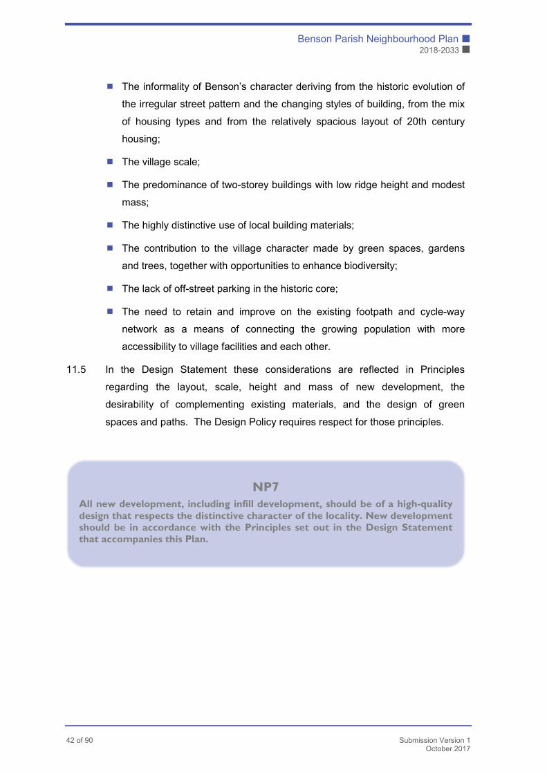
Benson Parish Neighbourhood Plan �
2018-2033 �
42 of 90 Submission Version 1
October 2017
� The informality of Benson’s character deriving from the historic evolution of
the irregular street pattern and the changing styles of building, from the mix
of housing types and from the relatively spacious layout of 20th century
housing;
� The village scale;
� The predominance of two-storey buildings with low ridge height and modest
mass;
� The highly distinctive use of local building materials;
� The contribution to the village character made by green spaces, gardens
and trees, together with opportunities to enhance biodiversity;
� The lack of off-street parking in the historic core;
� The need to retain and improve on the existing footpath and cycle-way
network as a means of connecting the growing population with more
accessibility to village facilities and each other.
11.5 In the Design Statement these considerations are reflected in Principles
regarding the layout, scale, height and mass of new development, the
desirability of complementing existing materials, and the design of green
spaces and paths. The Design Policy requires respect for those principles.
NP7
All new development, including infill development, should be of a high-quality design that respects the distinctive character of the locality. New development should be in accordance with the Principles set out in the Design Statement that accompanies this Plan.
� Benson Parish Neighbourhood Plan
� 2018-2033
Submission Version 1 43 of 90 October 2017
12. Infrastructure Policies
12.1 This section of the Plan addresses three of the identified objectives of the Plan,
namely:
� To ensure that new development contributes towards the free and safe flow
of traffic whilst having a minimum impact on the existing roads system and
on parking in the village.
� To ensure that new development encourages sustainable transport and
specifically includes adequate walking and cycling routes to access the
village centre
� To ensure that there are adequate facilities to serve our growing local
population
12.2 To address these objectives this section of the Plan will examine the current
situation regarding those elements of the infrastructure in Benson which are
provided by external agencies – usually Oxfordshire County Council. It will then
assess the potential impact of possible growth on the existing and future
infrastructure.
12.3 The remaining section of this chapter addresses transport, education and other
community facilities
Transport
12.4.1 Benson is located in central south Oxfordshire with good road links to Oxford,
Reading, Henley and the M40. Benson has two major roads within the parish,
the A4074 and the B4009. The A4074 runs past most of the parish adjacent to
the river and provides direct links with Oxford and Reading, whilst the B4009
cuts through the village and provides a link to Watlington and the M40 to the
east.
12.4.2 Some of the village roads are historic whilst others are more modern. However,
Benson has never benefited from a modern relief road. The result is that
modern traffic flows have to be accommodated in an environment ill-suited to
current circumstances. Providing a Relief road or securing the land for such a
road in the future is a key objective of this plan.
12.4.3 The village is served by regular bus services to Oxford, Reading and the
nearest town of Wallingford.
Benson Parish Neighbourhood Plan �
2018-2033 �
44 of 90 Submission Version 1
October 2017
12.4.4 Benson has no direct access to the rail network. The nearest stations are in
Didcot, Oxford, Cholsey, Henley and Reading.
12.4.5 The river provides a seasonal tourist service on an infrequent basis. RAF
Benson is an operational RAF station with no commercial services.
Transport Policies
12.5.1 The policies set out in this section of the Plan are designed to ensure that new
and existing residents of the Parish are not entirely reliant on the private car,
have realistic sustainable transport options, and are provided for in terms of
access & highways safety. This is a core pillar of sustainable development.
12.5.2 These aspects are now addressed in detail
Traffic Flow & Pinch Points
12.5.3 The following junctions have been identified as key points in the traffic flow
through Benson. A Transport Assessment can be found at Appendix F, data on
traffic Pinch Points at Appendix F1 and Traffic Flow is information is available
in Appendix F2.
Castle Square
12.5.4 Traffic converges from the Watlington Rd, Oxford Rd and Church Road. Parked
cars, a severe bend and a very narrow carriageway on B4009 produce
congestion at this point, especially at peak times. It is possible that this
junction may need a weight restriction in the future. This is a prime route for
children accessing the Primary School.
Church Road
12.5.5 Traffic converges from the main A4074 and Benson village/Watlington
Rd/Oxford Rd. This causes severe congestion especially at weekends when
the church is in use or when events are taking place in church premises during
week. Traffic into/out of the public library further complicates the traffic flow.
The southern end has a severe pinch point at the junction with the A4074, with
public parking down St Helens Avenue for Bus Stop and Riverside Café and
School Pick Ups.
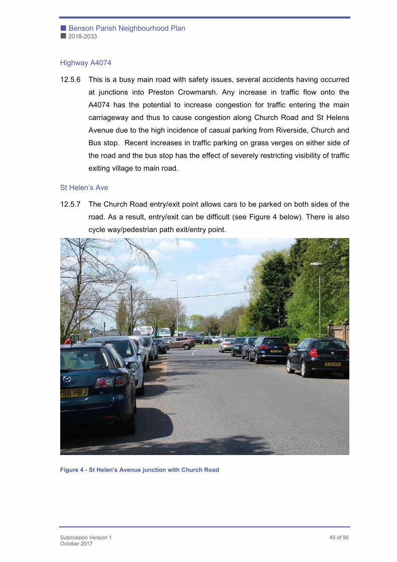
� Benson Parish Neighbourhood Plan
� 2018-2033
Submission Version 1 45 of 90 October 2017
Highway A4074
12.5.6 This is a busy main road with safety issues, several accidents having occurred
at junctions into Preston Crowmarsh. Any increase in traffic flow onto the
A4074 has the potential to increase congestion for traffic entering the main
carriageway and thus to cause congestion along Church Road and St Helens
Avenue due to the high incidence of casual parking from Riverside, Church and
Bus stop. Recent increases in traffic parking on grass verges on either side of
the road and the bus stop has the effect of severely restricting visibility of traffic
exiting village to main road.
St Helen’s Ave
12.5.7 The Church Road entry/exit point allows cars to be parked on both sides of the
road. As a result, entry/exit can be difficult (see Figure 4 below). There is also
cycle way/pedestrian path exit/entry point.
Figure 4 - St Helen's Avenue junction with Church Road
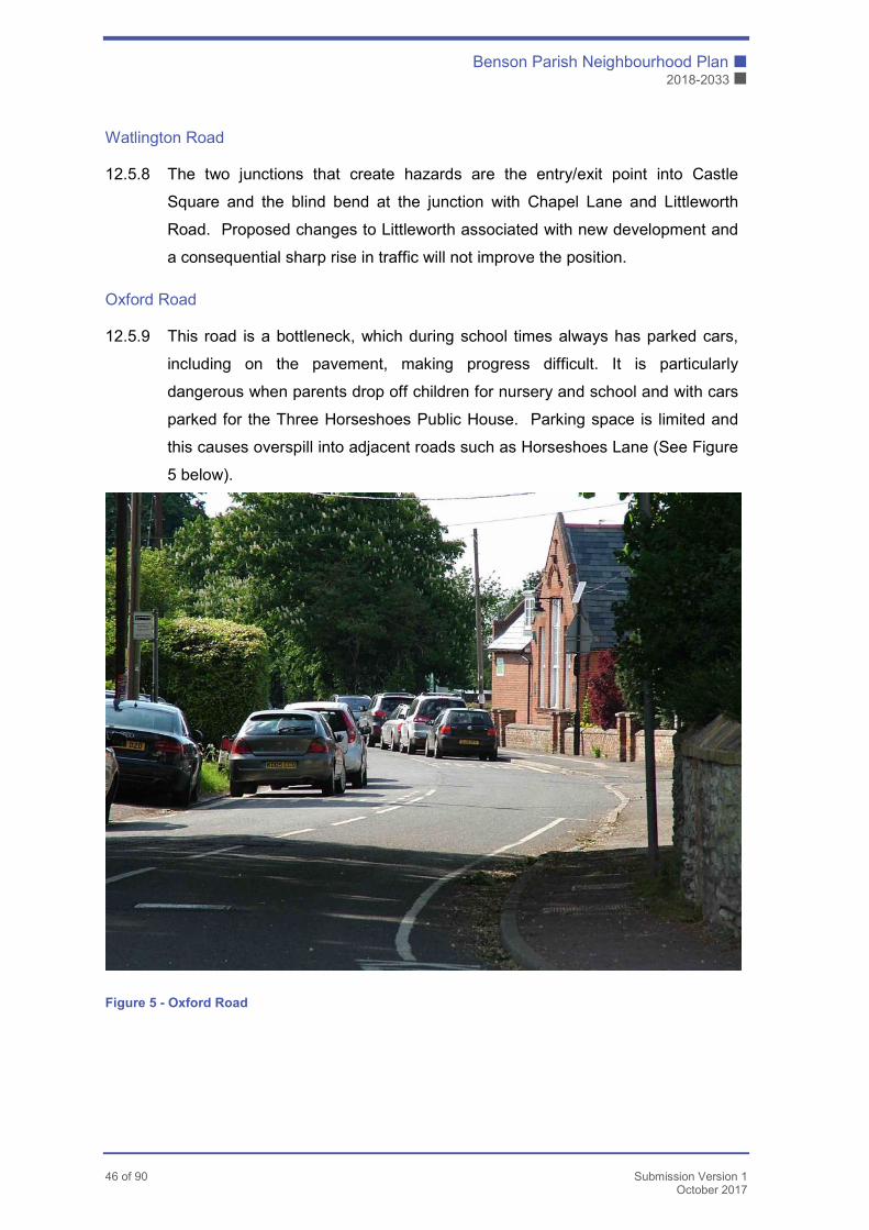
Benson Parish Neighbourhood Plan �
2018-2033 �
46 of 90 Submission Version 1
October 2017
Watlington Road
12.5.8 The two junctions that create hazards are the entry/exit point into Castle
Square and the blind bend at the junction with Chapel Lane and Littleworth
Road. Proposed changes to Littleworth associated with new development and
a consequential sharp rise in traffic will not improve the position.
Oxford Road
12.5.9 This road is a bottleneck, which during school times always has parked cars,
including on the pavement, making progress difficult. It is particularly
dangerous when parents drop off children for nursery and school and with cars
parked for the Three Horseshoes Public House. Parking space is limited and
this causes overspill into adjacent roads such as Horseshoes Lane (See Figure
5 below).
Figure 5 - Oxford Road
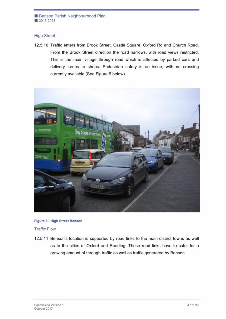
� Benson Parish Neighbourhood Plan
� 2018-2033
Submission Version 1 47 of 90 October 2017
High Street
12.5.10 Traffic enters from Brook Street, Castle Square, Oxford Rd and Church Road.
From the Brook Street direction the road narrows, with road views restricted.
This is the main village through road which is affected by parked cars and
delivery lorries to shops. Pedestrian safety is an issue, with no crossing
currently available (See Figure 6 below).
Figure 6 - High Street Benson
Traffic Flow
12.5.11 Benson's location is supported by road links to the main district towns as well
as to the cities of Oxford and Reading. These road links have to cater for a
growing amount of through traffic as well as traffic generated by Benson.

Benson Parish Neighbourhood Plan �
2018-2033 �
48 of 90 Submission Version 1
October 2017
12.5.12 Furthermore, Benson's road structure is historical and is not conducive to high
volumes of traffic or to large individual vehicles. Many roads have seen no
significant changes and a significant amount of heavy traffic uses them out of
necessity. Many of the issues raised would be addressed by the creation of a
new through route for traffic avoiding the village pinch points.
12.5.13 When considering future traffic flows, it is necessary to consider planned local
infrastructure improvements and to take them into account, if at all possible.
These have been identified as the planned Park & Ride at Sandford and the
proposed Relief Road around Watlington.
12.5.14 It can only be considered that a new large Park & Ride at Sandford will
encourage more vehicle journeys to / from Oxford, but quantifying the precise
effect on Benson is not possible at this stage. However, it would seem that
strategic developments in Culham and Berinsfield might benefit more from this
new facility than Benson, whilst Chalgrove traffic intending to use it would seem
unlikely to route via the B4009 and Benson when a more direct route to the
north is available. As far as Benson traffic is concerned, the route will likely
remain northbound on the A4074 as is currently used for Redbridge.
12.5.15 It is understood that the Watlington Neighbourhood Plan will also be proposing
a Relief Road around the village designed to route traffic away from the village
centre. We judge that the main effect of this on Benson would be to possibly
attract more traffic onto the B4009, with drivers hoping to make use of an
easier journey along this route. However, we understand that the existing
weight limit in Watlington itself will remain, such that there should not be a
dramatic increase in HGV traffic,
NP8
New development will be supported which:
� Improves existing road links or provides new ones to the main district towns and cities;
� Demonstrates that it does not detrimentally increase traffic flow conditions at the sensitive points listed above (para 9.5.4 to 9.5.10);
� Results in improvements to the free flow of traffic through the Housing Allocation sites (Policies NP2 – NP4).

� Benson Parish Neighbourhood Plan
� 2018-2033
Submission Version 1 49 of 90 October 2017
Parking
12.6.1 Benson is a historic village, with some old narrow roads, a Conservation Area
in its centre and limited central parking as a result.
12.6.2 On the village extremities, more modern developments have also resulted in
parking issues, with sites adjacent to the Marina and the School having
problems at certain times of day. A strategy is needed therefore to mitigate
existing problems whilst avoiding future ones when future development takes
place.
The strategy is to:
a) Optimise existing parking capacity in the village centre
b) Promote & encourage village centre access by non-vehicle means of
transport
c) Encourage the use of sustainable transport
d) Provide additional parking facilities wherever possible
e) Ensure future developments provide sufficient on-site parking facilities for
residents and visitors
The Strategy should be implemented by various means
� A Parish Council Parking Plan – see Appendix G
� This Plan being clear on what parking facilities are required from future
development
� The gradual implementation of the Plan over a period of time
12.6.3 There is a serious shortage of parking in certain key locations in Benson as
shown in The Parking Plan (Appendix G). It is likely that future demand for
parking will increase, not only from local traffic but also from traffic generated
out of the immediate area. In order to prevent this issue becoming more
pressing, off-site parking should be discouraged, whilst every effort should be
made to maximise existing parking capacity.
12.6.4 Specifically, the planned improvement in service of the Oxford/Reading route
may well attract more passengers from the new developments in Benson and
surrounding villages (such as Watlington) but it is judged that this will see an
increase in demand for local park & ride with vehicles being parked near the
A4074. This has already happened in Lewknor with the Oxford/London bus
Benson Parish Neighbourhood Plan �
2018-2033 �
50 of 90 Submission Version 1
October 2017
service, and it seems logical that a similar situation will arise to some degree in
Benson. Such a trend does nothing to help with traffic flows at the critical pinch
points in Benson whilst simultaneously increasing the parking issues.
Sustainable Transport
12.7.1 The principle of sustainability is well established in national & local policies
including the NPPF. Of particular importance are strategies that secure the
provision of services that people can access easily without resorting to private
car travel, and the provision of infrastructure which encourages and supports
the use of sustainable transport modes including walking/cycling. Recently
published guidance from Public Health England on air quality emphasises the
importance of planning development such that walking and cycling are
encouraged. The guidance also encourages measures that separate
pedestrians and cyclists6.
12.7.2 Pedestrians currently use a network of paths that are a legacy from the past,
and are not necessarily always relevant to modern day requirements. Whilst
the number of paths is adequate in some parts of the parish provision for
pedestrians in many parts of the village is non-existent or inadequate. It is vital
that future development is planned so as to provide adequate facilities from the
outset.
12.7.3 At present, Hale Rd, part of Watlington Rd, part of Brook St, Castle Square,
Crown Square, parts of Oxford Rd and Church Rd all have inadequate
provision for walkers in that the walkways are non-existent or inadequate.
12.7.4 There is an established system of public footpaths. Some may not appeal to
users because they are narrow and enclosed. However other more open and
attractive examples add to the distinctive rural character of the village by
6 https://www.nice.org.uk/guidance/ng70
NP9
Developers will be expected to provide as a minimum the parking provisions set out in National and County Guidelines. Where it would be appropriate to the overall design and layout of the development concerned, proposals which deliver car parking in excess of the minimum standards will be supported.
� Benson Parish Neighbourhood Plan
� 2018-2033
Submission Version 1 51 of 90 October 2017
providing valuable short cuts. They help to preserve Benson's historic links with
adjacent settlements. A map showing these paths in in Appendix H.
12.7.5 As new development is being planned, it is important that the connectivity
aspect is prioritised as a design consideration. New paths need to not only
connect to the existing village centre as much as possible, but they also need
to connect one with the other. They should take account of the existing paths,
and desire lines as much as possible to encourage pedestrian activity. They
must also take into account the need to access public transport.
12.7.6 Circular routes, taking in valuable views and routed so as to allow pedestrians
to enjoy areas of value for wildlife or having aesthetic appeal are particularly
popular and offer the additional opportunity to support and encourage
understanding and appreciation of the local environment. Other measures to
address this objective are presented elsewhere in this Plan.
Accessibility
12.8.1 Benson still has several sites where a dropped kerb is not provided, which
creates difficulties for anyone with mobility issues. These existing issues have
the potential to be improved where they will be used by newly created paths
leading to/from development sites.
12.8.2 The present facilities to assist potential cyclists are not extensive. Many of
Benson's roads are narrow and not conducive to cycling in busy traffic.
Installing cycle lanes would seriously affect the road capacity. There is only
currently one designated cycle path in the parish – and that is a shared use
with pedestrians and skirts the village alongside the A4074.
12.8.3 The provision of new cycle paths will be expected in all significant development
proposals. Cycle facilities such as storage and security points will also be
expected and improvements to the present infrastructure will be sought.
12.8.4 Other areas of this section of the Plan will comment on the need for
encouraging pedestrian/cyclist activity to reduce vehicle usage. This needs to
be done in a managed programme, taking account of with both physical and
psychological approaches to inducing and supporting use. Improved
awareness of facilities by signage and education will be a priority, and
concerns over safety should be addressed to encourage use.
Benson Parish Neighbourhood Plan �
2018-2033 �
52 of 90 Submission Version 1
October 2017
12.8.5 If the future use of paths is to be improved and then maintained, it is also
important that their nature and availability are addressed. Paths need to look
attractive to encourage use. They should not make users feel threatened by
closed in surroundings and should be sited so as to build in natural surveillance
in developments. Space for bio diversity should be designed in from the start,
recognising the role that footpaths need to play as corridors for wildlife as well
as people. Equally though, they must be fit for purpose, with long term
maintenance also addressed.
Public Transport
12.9.1 The Plan considers that public transport is important to the future of the Plan
area. This section will assess the existing distances to the current transport
stops, and future suggestions to improve the required walk distance will be
encouraged.
12.9.2 Currently Benson is served by just one bus company - Thames Travel [TT].
This company provides Benson with two commercial services.
12.9.3 The Plan area benefits from being between two major towns Reading and
Oxford and as a result it enjoys a regular and frequent service in either
direction. The service is split between the X39 that calls in at Wallingford and
the X40 that calls in at Wallingford and Woodcote. The most useful stop for
Benson residents is at the Benson Marina, with a further stop at the end of
Benson Lane, both on the A4074.
12.9.4 Thames Travel also run a regular service between Cholsey - Wallingford – RAF
Benson, the 136 service. This service runs through the centre of Benson with
stops at Church Road, College Farm, Blacklands Road and The Cedars before
heading off to Ewelme and the RAF Base. This is a much-used service as it
gets passengers to Wallingford, which is used as an exchange hub to allow
transfers for Reading, Oxford, Didcot and Abingdon.
12.9.5 The changes following the loss of the County subsidy have seen the dropping
of several small less used routes, and also the direct service to Henley.
12.9.6 In summary, Benson is well served for public transport. However, much needs
to be done to encourage residents to use the bus more. A recent limited
community user survey showed the service to Wallingford was well used at
certain times and especially by the older persons taking advantage of bus pass
� Benson Parish Neighbourhood Plan
� 2018-2033
Submission Version 1 53 of 90 October 2017
travel and by young persons. The survey also suggested that none of these
services are run at anywhere near peak capacity.
12.9.7 Benson currently has a reasonable bus service to local towns, but the future of
these services is uncertain. The County subsidy for the key local service has
ended and any future commercial operation will stand or fall on usage. This is
illustrated by recent reductions in service by Thames Travel on the 136 service,
with the likelihood of further reductions in the near future.
12.9.8 Benson is well served by strategic bus services to Oxford & Reading. The
County Transport Plan proposes to improve these services which are expected
to result in more commuting traffic parking inside Benson to access the
services, as discussed in para 9.6.4 above.
River Transport
12.10 There is only one company running river transport on the Thames through
Benson – Salters Steamers. This service is limited and operates three days a
week (Monday, Friday & Sunday), with one boat per day to/from Abingdon and
only operates during the summer. It is plainly designed for leisure use rather
than regular transport
Air Transport
12.11 The local Airfield is RAF Benson, an operational RAF base with no commercial
services.
Pedestrians & Cyclists
12.12 Benson is located in relatively flat terrain that lends itself to walking, but there
are currently insufficient arrangements for pedestrians. Furthermore, Benson's
NP10
New developments will be required to:
� Provide on-site footways to encourage access to public transport routes; � Contribute towards measures designed to encourage access to strategic
bus services; � Set out in their Travel Plans measures to invest in existing and new bus
services to enable commuters, school children and other users to access Oxford, Reading and Wallingford.
Benson Parish Neighbourhood Plan �
2018-2033 �
54 of 90 Submission Version 1
October 2017
historic road structure does not lend itself easily to establishing new cycle
routes on existing roads.
Sustainable Travel
12.13 There is a local view that provision is not being made for future sustainable
modes of transport. Such provision is important to secure sustainable and
environmentally acceptable solutions to transport in the Plan area. Policy NP13
takes account of the recent government decision to move away from fossil fuel
cars to electric cars by 2040. Whilst this is beyond the Plan period it is likely that
manufacturers will bring forward more electric vehicles well before this deadline.
This has already been reflected in the various 2017 car scrappage schemes for
cars registered before 2009 and operating at EU1-4 emissions standards.
Road Safety
12.14.1 The recent Community Survey indicated that a large proportion (95%) of the
respondents had concerns over road related issues. This section of the Plan
will seek to identify safety concerns reported and then assess them in the light
NP11
New developments should provide on-site footways & pedestrian safety measures to facilitate pedestrian access to the village centre and community facilities and to surrounding countryside and settlements. These footways should incorporate and link with existing footway networks, and should be in accordance with principles H1 – H6 of the Design Guidance.
New development should provide on-site cycle paths both in general, and to facilitate access to the village centre and community facilities, and to surrounding settlements. They should also contribute where relevant to improvements to existing cycling facilities.
Where possible, footpaths should be routed so as to provide separation between road traffic and people.
NP12
Proposals for new residential developments which include EV charging points that are appropriate to the scale and nature of the development concerned will be supported.

� Benson Parish Neighbourhood Plan
� 2018-2033
Submission Version 1 55 of 90 October 2017
of possible future development. It will not examine other issues reported such
as parking or traffic flow since they are examined elsewhere in this Plan.
12.14.2 A high proportion (89%) of respondents also reported believing there are road
safety issues in Benson, with the following identified as safety related:
Speeding, Busy Junctions, Heavy Lorries and Pedestrian/Cyclist issues
12.14.3 Several specific sites were mentioned by those reporting safety issues,
including Benson High St, Watlington Rd, Oxford Road, Church Rd/A4074
Junction and Castle Square
12.14.4 The judgement of speeding is of course very subjective, with many factors –
traffic flow, road design, surroundings – playing a part in the assessment as
well as the actual speed of the vehicle.
12.14.5 The perception of high speed (and hence of a lack of safety) is completely
different and it could well be that in certain places and/or certain times the
existing limit is too high. The Plan’s focus is on Benson High St, Watlington Rd,
Oxford Rd and the A4074 Marina area.
High Street
12.14.6 This road does not have a high average speed where measured (20 mph) nor
a high 85% Quartile Speed (25 mph), but it has many other factors which
combine to affect safety when combined with the current legal limit. The high
numbers of vehicles parked or manoeuvring, the constant turning of vehicles
onto/off the road, the need for pedestrians to cross the road and the likelihood
of them doing so in between parked vehicles all have a bearing on the speed
limit. Further, the incidence of illegally parked vehicles, both on restricted
yellow lines and in the immediate vicinity of junctions, has a significant impact
on safety.
12.14.7 The High St would fit well with National & County Guidelines on a 20mph limit,
and hence it is felt that consideration be given to reducing the speed limit along
the High St to 20mph.
Oxford Rd
12.14.8 The Traffic Survey Data show a different picture for Oxford Rd alongside
Benson CofE School. Average speeds are much higher, whilst
parked/manoeuvring vehicles are only an issue at particular times.
Benson Parish Neighbourhood Plan �
2018-2033 �
56 of 90 Submission Version 1
October 2017
12.14.9 However, during these times – when children are being dropped off/picked up –
the road becomes a basically one lane road with relatively high speeds. Future
development in Benson is likely to exacerbate the problem, with more children
and more parked cars.
12.14.10 It is not uncommon to find a part time lower speed limit outside schools, and
indeed OCC Highways are recommending a 20mph limit for the proposed new
Littleworth Rd on the other side of the school. It is therefore suggested that
consideration be given to lowering the speed limit in Oxford Rd in the vicinity of
the school to 20mph when the school is active.
Specific Issues – Busy Junctions
12.14.11 At the sites identified by survey respondents, the most common threat to road
safety would seem to be in crossing highways with a high traffic count at
certain times of day. Church Rd/A4074, Watlington Rd and Castle Square all
fall into this category.
Watlington Rd
12.14.12 A new crossing is scheduled for Watlington Rd near the tennis courts as part
of an already approved development. This will do much to improve safety.
However, nothing is planned as yet to assist pedestrians at the eastern end of
the revised Littleworth Rd. Some form of crossing here is a high priority.
Castle Square
12.14.13 This is a very busy junction at peak traffic times, and also another important
point on the walk to school for parents & children. However, the restricted
visibility problems associated with the various roads here make any potential
crossing very difficult. This also not helped by the incidence of parked vehicles
in the Square.
12.14.14 It could well be that encouraging traffic to route away from this point is more
effective and rewarding. This would be best done by a new Relief Road
designed to take heavy traffic and thus avoiding the narrow entry point into the
square.
A4074 Junction
12.14.15 The junction of Church Rd/A4074 is a very busy junction in peak traffic times,
and the A4074 has a higher speed limit (40mph). Pedestrians seek to cross the
� Benson Parish Neighbourhood Plan
� 2018-2033
Submission Version 1 57 of 90 October 2017
busy highway here for many reasons, to access Preston Crowmarsh, to access
the riverside for recreation and to access the main Oxford bus service.
12.14.16 On this basis there would seem to be a case for installing a controlled crossing
such as exist now in Berinsfield and Shillingford. This would tend to slow the
traffic flow down, thus improving the current perception of high speed.
12.14.17 The other issue reported in this area concerns the traffic accessing the A4074
from Church Rd. This access needs improvement. There are several possible
improvements possible, including the prohibition of traffic making a right turn
across the A4074 in the Oxford direction. Such traffic blocks visibility for traffic
in the left-hand lane and inhibits that traffic from turning left safely.
Alternatively, a light controlled junction with an associated crossing might be
considered.
Heavy Lorries
12.14.18 Benson does see a great deal of what is perceived to be heavy goods traffic,
with several major operators in the Parish. However, this traffic has a legal right
to access.
Specific Issues – Pedestrians/Cycles
12.14.19 The vast majority of the comments received from the Community Survey in
this category are involved with road crossings and/or high speeds. These have
been addressed above and an improvement in public perception would follow
any implementation.

Benson Parish Neighbourhood Plan �
2018-2033 �
58 of 90 Submission Version 1
October 2017
13. Community Facilities' Policies
13.1 This section addresses three of our identified objectives namely items:
(a) Ensure Benson has a modern, vibrant village centre.
(b) Ensure there are adequate facilities to serve our growing local population.
(c) Ensure sustainability of economic activity in the Neighbourhood Plan area.
13.2 Benson is fortunate in having an extensive range of local infrastructure facilities
that help make the village both an attractive place to live and one that supports
its residents. The key facilities that currently support the Benson community
are shown in the table below and those within the village centre and wider
community are shown in Figure 7 and Figure 8 below.
LOCAL INFRASTRUCTURE FACILITIES
Retail outlets Health Services etc Community meeting places
Service providers
Co-operative convenience store
Millstream GP Surgery Parish Church & Canon Room multi-purpose hall
Outreach post office
Butcher Dentist Parish Hall 2 Pubs
Greengrocer and Florist Veterinary surgery Youth hall 2 hairdressers
Cards, stationery & gift shop
Chiropractor Scout hut 2 garage/car repair facilities
Pharmacy and chemist Day Centre for elderly Library Estate agent
M&S convenience store (at Elm Bridge roundabout site)
Café and 2 take-away food outlets
Recycled furniture & gifts
Café beside River Thames
Delicatessen Fuel station
Health & beauty items Charity Shop
Fishing tackle & outdoor clothing shop

� Benson Parish Neighbourhood Plan
� 2018-2033
Submission Version 1 59 of 90 October 2017
Retail and service facilities in village centre; note the large number of parked cars
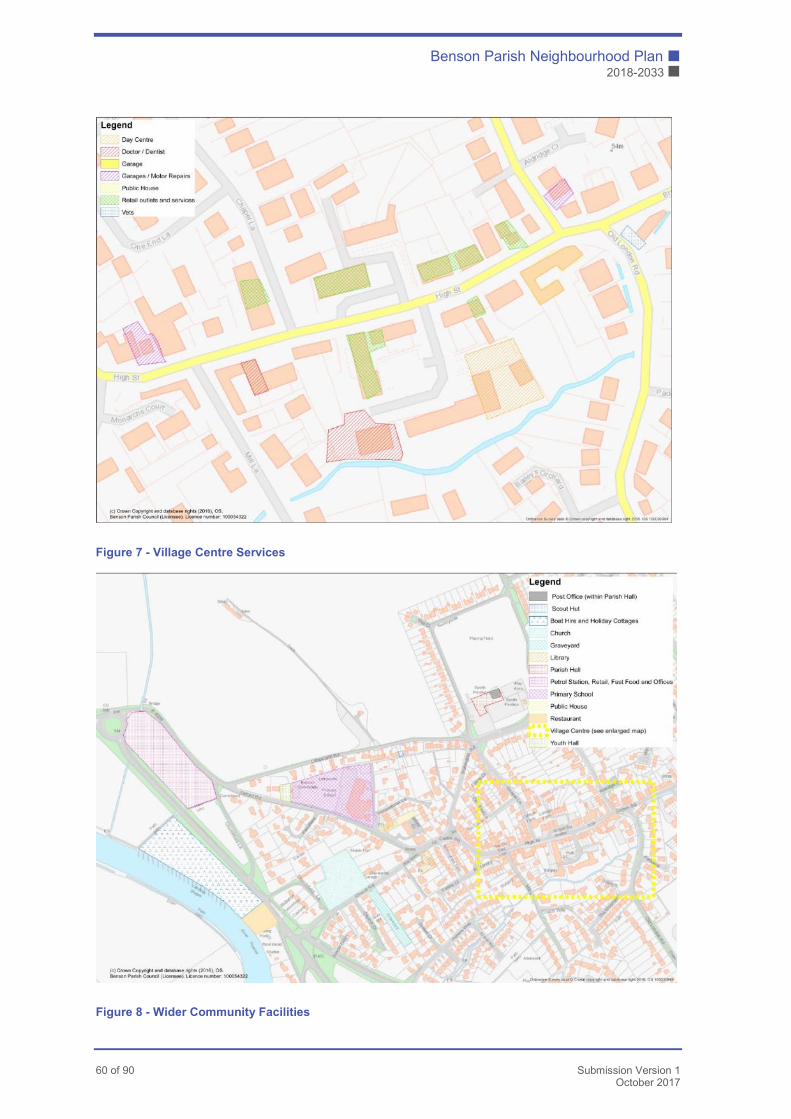
Benson Parish Neighbourhood Plan �
2018-2033 �
60 of 90 Submission Version 1
October 2017
Figure 7 - Village Centre Services
Figure 8 - Wider Community Facilities
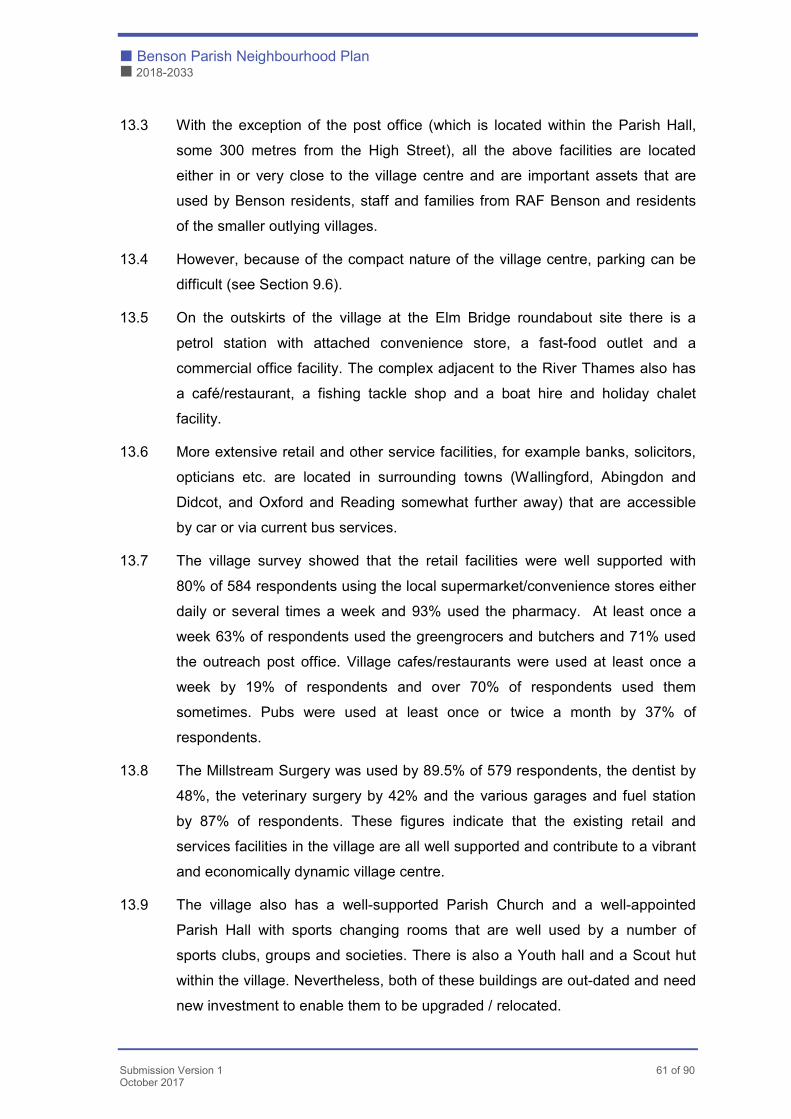
� Benson Parish Neighbourhood Plan
� 2018-2033
Submission Version 1 61 of 90 October 2017
13.3 With the exception of the post office (which is located within the Parish Hall,
some 300 metres from the High Street), all the above facilities are located
either in or very close to the village centre and are important assets that are
used by Benson residents, staff and families from RAF Benson and residents
of the smaller outlying villages.
13.4 However, because of the compact nature of the village centre, parking can be
difficult (see Section 9.6).
13.5 On the outskirts of the village at the Elm Bridge roundabout site there is a
petrol station with attached convenience store, a fast-food outlet and a
commercial office facility. The complex adjacent to the River Thames also has
a café/restaurant, a fishing tackle shop and a boat hire and holiday chalet
facility.
13.6 More extensive retail and other service facilities, for example banks, solicitors,
opticians etc. are located in surrounding towns (Wallingford, Abingdon and
Didcot, and Oxford and Reading somewhat further away) that are accessible
by car or via current bus services.
13.7 The village survey showed that the retail facilities were well supported with
80% of 584 respondents using the local supermarket/convenience stores either
daily or several times a week and 93% used the pharmacy. At least once a
week 63% of respondents used the greengrocers and butchers and 71% used
the outreach post office. Village cafes/restaurants were used at least once a
week by 19% of respondents and over 70% of respondents used them
sometimes. Pubs were used at least once or twice a month by 37% of
respondents.
13.8 The Millstream Surgery was used by 89.5% of 579 respondents, the dentist by
48%, the veterinary surgery by 42% and the various garages and fuel station
by 87% of respondents. These figures indicate that the existing retail and
services facilities in the village are all well supported and contribute to a vibrant
and economically dynamic village centre.
13.9 The village also has a well-supported Parish Church and a well-appointed
Parish Hall with sports changing rooms that are well used by a number of
sports clubs, groups and societies. There is also a Youth hall and a Scout hut
within the village. Nevertheless, both of these buildings are out-dated and need
new investment to enable them to be upgraded / relocated.

Benson Parish Neighbourhood Plan �
2018-2033 �
62 of 90 Submission Version 1
October 2017
13.10 Benson residents welcome and make good use of the range of facilities that
are available to them within the village and are keen that they are both
continued and where necessary enhanced. However, should the village
population grow significantly, the need to improve/increase facilities particularly
in respect of the Millstream Surgery, primary school, dentist, post office, library,
Parish Hall, youth club and scout hut will need to be addressed.
13.11 Large scale development will require improved community facilities in many
areas of Benson. Some of these facilities will not directly be associated with
particular developments. It is important that such improvements are identified
and listed for future action.
Education
13.12.1 The provision of education for children in Benson Parish is important to its
community function and sustainability.
13.12.2 Provision generally is made by Benson Church of England School, RAF
Benson and by Scamps. Within 5 miles of Benson there are currently between
21 nurseries (www.childcare.co.uk) and 8 nurseries (fisd.oxfordshire.gov.uk)
along with 24-34 registered childminders depending on the search engine
used.
13.12.3 General provision and the allocation of places is the responsibility of the County
Council. There are two state primary schools within Benson Parish – Benson
CofE School and the RAF Benson School. There are another seven Primary
Schools within three miles of Benson
Currently, the capacities of the two schools within the Parish are:
NP13
Proposals which assist with the delivery of new or extended community facilities or infrastructure improvements will be supported. Delivery of community facilities listed in Appendix I – Community Facilities will be particularly supported.

� Benson Parish Neighbourhood Plan
� 2018-2033
Submission Version 1 63 of 90 October 2017
Capacity On Roll (2016)
Benson CoE 210 179
RAF Benson 246 180
Combined 456 359
13.12.4 The current (and approved) planning applications for land adjacent to
Littleworth Rd in Benson involve a proposal to extend the Benson CoE School
on the existing site's playing fields, whilst providing new playing field facilities
for formal games and PE off site (on the Littleworth Rd development across the
road from the school). The current County Council intention is to expand the
school to 1.5 FE (315 places) with 2 FE (415) places a possibility. This situation
will be kept under review as the scale of expected housing growth is clarified.
13.12.5 RAF Benson School is in the catchment area of Watlington, and many pupils
go to Icknield Community College. Benson CofE School is in the Wallingford
catchment area and is a Partner school, and hence most pupils go there.
13.12.6 Wallingford School is already operating at its capacity of an intake of 190 pupils
per year and is heavily over-subscribed with a waiting list. However, the school
regularly accepts late arrivals with a result that nobody from the catchment
area has been forced elsewhere in recent years.
13.12.7 Consideration is being given to extend the school in line with the growth of local
population and a recent study has indicated there is capacity for the site to
cope with expansion. However, the details are a matter for the school and the
County Council. The figures below were given by the School earlier:
Year Yr7 Yr8 Yr9 Yr10 Yr11 6th Form Total
2016 192 202 192 191 190 210 1163
13.12.8 Icknield Community College is an 11-16 school with no sixth form currently and
an admission number at present of 140 pupils per year. Current figures for
pupils are:
Year Yr7 Tr8 Yr9 Yr10 Yr11 Total Capacity
2016 142 128 122 100 120 612 700

Benson Parish Neighbourhood Plan �
2018-2033 �
64 of 90 Submission Version 1
October 2017
13.12.9 The situation regarding secondary education is clearly volatile. To take Icknield
Community College as an example, potential housing growth in Chinnor,
Chalgrove, Watlington, Stadhampton as well as Benson, means that the future
demand for places will undoubtedly be high but the detail is unknown and the
future is therefore uncertain.
13.12.10 As there is no secondary school within Benson, transporting children to school
is a necessity. The challenge is to find the safest and most sustainable
practical method to transport the children to a school with the capacity to
accept them.
13.12.11 The exact number of children resident in Benson requiring a school place will
depend on the mix and numbers of dwellings proposed. Recent figures from
County suggest the following projected requirement:
Dwellings Primary Places Needed Secondary Places
Needed
175 35 25
240 65 50
400 100 75
600 150 105
800 200 150
13.12.12 Whilst the details of the planned expansion of Benson CoE School are not
currently known, it has been confirmed by OCC that there is a limit to possible
expansion, and that this will only support a maximum of 750 to 800 new
houses. This figure must take into account the small number of houses built as
infill (about 25) as well as the houses currently approved for site Ben 1 (about
425). Hence the houses proposed for all other sites within the Benson NP
should not exceed the range 290 to 340.

� Benson Parish Neighbourhood Plan
� 2018-2033
Submission Version 1 65 of 90 October 2017
Key Issues
13.12.13 Given that Primary school places & allocations will inevitably be critical, it is
suggested that the County's placement system needs to ensure that the best
use is made of all available educational resources within the parish to ensure
they are effectively utilised.
13.12.14 Most Benson parents want their children be educated to an acceptable
standard in a local school without the need for excessive travelling. In this
respect, there are two key issues involved - school capacity and transport.
13.12.15 The provision of sufficient school places, both Primary and Secondary is
currently a County Council responsibility. However, the NP recognises that the
speed of delivery of the land for school use as well as the land for the houses
will be critical. This is likely to be a lengthy programme and it must be expected
that OCC will need to regulate the timescales.
13.12.16 However given that the traffic on Benson's roads will increase with new
development, it is important that the Plan supports measures that minimise the
use of vehicles to transport children to school.
13.12.17 Hence this Plan acknowledges and supports the need for school expansion on
sustainability grounds. However, the Plan strongly encourages that the School
Trustees retain as much as possible of the existing School Field as green
space to allow easy access to green space for informal break-time recreation. It
is understood that a feasibility study for the expansion has been commissioned
by OCC which will determine the area required.
Benson Library
13.13.1 Benson Library is a modestly sized building (approx. 128m2) on a small plot
near the centre of Benson village. It currently has limited car parking facilities,
a difficult access and has no immediate prospect of improvement. The library is
run by Oxfordshire County Library Services (OCLS) in a Partnership Working
Agreement with the Friends of Benson Library (FOBL)
13.13.2 In their submission to a major recent successful planning application, the
County stated that the library is “significantly undersized in relation to its
catchment area” and this development will fund an increase in size to cater for
Benson Parish Neighbourhood Plan �
2018-2033 �
66 of 90 Submission Version 1
October 2017
the increased population generated. The County Council has no current plans
to move the library from its present site. However, it is understood that OCLS
will consider any proposals that come forward to move the library to another
suitable location within the community.
13.13.3 It is unlikely that the current library site can accommodate a large increase in
building size, not least over the loss of car parking which this would cause.
Such car parking is regarded by FOBL as important for the future of the library
given that a large proportion of library customers (over 40%) live outside
Benson village.
13.13.4 Furthermore, it is anticipated in any event that a larger library building will be
required in the village to accommodate the level of growth promoted in this
Plan.
13.13.5 One possible way forward would be to locate the library with or alongside a
Community Facility such as a Heritage or Local History Centre. Benson is an
historic village especially when the local RAF Base. FOBL, having discussed
the matter with OCLS, has submitted a scoping paper for the future of the
library which includes incorporating a Heritage or Local History Centre. FOBL
advise that OCLS is supportive of a more detailed review of the future of
Benson Library and has forwarded this scoping paper to OCC’s Property
Services for comment.
13.13.6 On this basis it is not possible at the moment to draft a detailed policy for the
Plan. Nevertheless, a general policy is set out below at NP14.
13.13.7 It is likely that the current site of Benson Library will be unsuitable for future
expansion and a new site will be required.
NP14
Proposals to extend the existing library or to provide a new facility elsewhere in the village will be supported where they comply with other policies in this Plan and the wider development Plan.
� Benson Parish Neighbourhood Plan
� 2018-2033
Submission Version 1 67 of 90 October 2017
Village Centre
13.14.1 The maintenance and ongoing development of Benson village centre, based
around the present retail properties in the immediate vicinity of the High Street,
is a prime requirement of the Plan. Earlier sections of this chapter have set out
the use of the local facilities in the village centre. They are a critical part of the
character and function of the Plan area. The retention of a strong village centre
is at the very heart of sustainable development in Benson. A key element of the
vitality and viability of the centre is based on its attractiveness as a shopping
centre. Policy NP15 has been designed to retain retail units unless it can be
demonstrated that for viability or other commercial reasons that it would be
unreasonable to do so. Policy NP 16 takes a similar view with regards to
residential and other commercial units. These will assist in reinforcing the
central role that the centre plays in village life.
NP15
Proposals for a change of use from A1 retail shops to other uses in the identified village centre or at the Elm Bridge roundabout site as shown on the Policies Map will only be supported where one of the following conditions is met:
� It has been satisfactorily demonstrated that it would be neither economically viable nor feasible to retain the existing or previous retail use in the property concerned and that there is no reasonable prospect of securing an alternative retail use; or
� The proposed non-retail use meets an identified community need and does not affect the integrity of the retail area concerned.
Benson Parish Neighbourhood Plan �
2018-2033 �
68 of 90 Submission Version 1
October 2017
13.14.2 Any significant increase in population within the Neighbourhood Plan area will
have major impact on the services and facilities available within the village. To
ensure that both existing and new residents continue to enjoy community
infrastructure, it will be necessary to put in place an infrastructure plan detailing
what facilities will need to be enhanced, what the time-frame is for those
changes and who will be responsible for meeting any costs incurred (including
agreed contributions from developers).
Assets of Community Value
13.15 A register of Assets of Community Value has been set-up and maintained by
the Parish Council. The register includes three facilities – The Crown Public
House, The Three Horseshoes Public House and the Benson Library. These
assets are also formally recorded on the local planning authority’s register of
such assets. The major areas where enhancements will be required include the
Millstream Surgery, primary school, post office, library, Parish Hall, Youth hall
and Scout hut. Car parking within the village is already difficult; additional
provisions need to be identified, and plans put in place for its enhancement.
NP16
Insofar as planning permission is required proposals for the change of use of residential or commercial buildings within the identified village centre (see the Policies Map) to retail (Class A1), to financial and professional services (Class A2), to café/restaurant (Class A3) or to business use (Class B1) will be supported subject to the following criteria:
� The proposal respects the character and appearance of the Benson conservation area and conforms with the principles E1-3 and K1-7 in the Benson Design Statement;
� The proposal does not cause an unacceptable impact on the amenities of nearby residential properties;
� The proposal provides adequate servicing and access arrangements in accordance with the most recently published standards of South Oxfordshire District Council;
� The proposal does not conflict with Policy NP15.
NP17
Any proposal that will result in either the loss of an Asset of Community Value or in significant harm to an Asset of Community Value will be not be supported.
� Benson Parish Neighbourhood Plan
� 2018-2033
Submission Version 1 69 of 90 October 2017
Burial Ground
13.16 The existing burial ground opposite the Parish Church will be full within the next
few years, and suitable space for a new burial ground needs to be identified
and set aside. The Church and the Parish Council have established that the
best site for this is on the southern side of St Helens Avenue because of
proximity to the Church, availability of good parking and where there is no risk
of flooding. It is proposed that an area of approximately 0.25ha be set aside on
site BEN7, land off St Helens Road, for this purpose (see Policy NP5).
Doctors Surgery
13.17.1 Existing healthcare facilities in the village will not be able to meet the needs of
an enlarged population. Based in the village centre the existing GP practice is
an integral part of the community and the doctors would like to grow and
expand the building and staff to support the housing growth planned in Benson.
Therefore, the Oxfordshire Clinical Commissioning Group would look to both
the Parish Council and the Local Planning Authority to consider supporting this
new population from Community Infrastructure Levy (CIL) contributions.
13.17.2 The potential projects identified in Appendix I will be developed into specific
projects that will be costed and phased and will be secured either through CIL
or S106 contributions where this is directly related to a development proposal.
Other sources of funding (e.g. Grants) will also be investigated. The projects
identified at Appendix I are based on current circumstances. The list will be
maintained and reviewed annually by the Parish Council.
13.17.3 Economic activity within the Neighbourhood Plan area is primarily linked to the
retail and service facilities within the village, although the RAF base also
employs many people who use village facilities. At Preston Crowmarsh, parts
of Battle Farm have been converted into office units and a conference centre
with parking. Limited local employment opportunities exist within the Elm
NP18
Community Infrastructure Levy contributions from development will be used for the benefit of the community, including projects listed in Appendix I.

Benson Parish Neighbourhood Plan �
2018-2033 �
70 of 90 Submission Version 1
October 2017
Bridge roundabout complex and at the riverside. Many residents travel out of
the village to places of employment, some of which are local within Wallingford
and environs or at Abingdon, Didcot, Reading and Oxford. Because of
reasonable access to the M4 and M40 motorways and to Didcot and Oxford
railway stations there is access to employment beyond the immediate area.
Phone and Broadband Provision
13.18.1 There are a number of farms and small commercial operations throughout the
Plan area. Some local residents work from home, assisted by the recent
introduction of improved fast fibre-optic broadband connections to the village.
The benefits to the community of home-working are considerable as it reduces
traffic and enhances support of village facilities.
13.18.2 Although current mobile phone signal strength within the Neighbourhood Plan
area is generally adequate there is a risk that increased demand from new
homes may overload existing facilities. The Parish Council should monitor the
situation and put pressure on service providers should residents report
deteriorations in the system.
13.18.3 The following policies have been developed to deliver the sustainable
economic activity objective:
NP19
Developers should provide appropriate, future-proofed infrastructure, such as fast Internet access, to all new dwellings within the Plan area. All applications for residential development must contain a ‘Connectivity Statement’ and developers will also be required to provide suitable ducting to enable more than one service provider to provide a fibre connection to individual properties from connection chambers located on the public highway.
� Benson Parish Neighbourhood Plan
� 2018-2033
Submission Version 1 71 of 90 October 2017
Allotments
13.19 Benson currently has 109 allotment plots (2.43 ha for 4754 people), and Parish
Council usage data (see Appendix J) over the past 5 years confirms high
uptake (between 94 and 100%). Development in the parish is expected to
increase demand so this Plan provides for additional allotments in NP2 and
NP5 to complement the existing provision on the south-western edge of the
settlement. SODC standards7 require 0.3 ha of allotment space per 1000
people, reflecting average provision in the larger settlements in the District.
This is less than the current scale of provision in Benson, which is calculated
as 0.51ha per 1000 people and considerably less than the national allotment
standard suggested by The National Society of Allotment and Leisure
Gardeners (NSALG). The SODC 2013 analysis acknowledges that demand for
allotment space is rising, and the evidence of high uptake in Benson indicates
that above average provision of 0.51ha per 1000 people is justified as it is in
proportion with Benson’s apparent needs.
7http://www.southoxon.gov.uk/sites/default/files/Standards summary with justification.pdf
NP20
Proposals that deliver the expansion of electronics communication networks and high-speed broadband and improvements to connectivity will be supported where:
� the applicant has fully explored the opportunities to erect apparatus on existing buildings, masts or other structures; and
� the number of radio and telecommunication masts are kept to a minimum consistent with the efficient operation of the network; and
� the development has been sited and designed to minimize the impact on the character and appearance of the Benson Conservation Area.
NP21
Provision should be made for allotment space (at a rate of 0.51 ha per 1000 people) in the green spaces within the new residential developments as proposed in policies NP2 and NP4 in this Plan.

Benson Parish Neighbourhood Plan �
2018-2033 �
72 of 90 Submission Version 1
October 2017
Outdoor Recreation
13.20.1 There are four formal recreation grounds in Benson. The primary site is
Sunnyside which provides a playground, tennis courts (restricted to club use so
inaccessible to casual users), a sports pavilion and amenity grassland put to a
variety of uses including football. There are two smaller playgrounds at Green
Close and St Helen’s Avenue, and Rivermead (adjacent to the River Thames)
provides a small paddling pool.
13.20.2 The Plan area also benefits from the recreational opportunities offered by good
access to the wider countryside and its network of footpaths and bridleways
including the Thames Path National Trail. Safe pedestrian crossings where
public footpaths intersect with busy roads around the village are particularly
important.
13.20.3 Community views on provision of youth facilities were assessed by a sub-group
of the Parish Council in February 2015. With respect to play facilities, that
survey indicated that the community believes that:
� there is a need for a greater variety of equipment at the existing
playgrounds, including ‘adventure’ type equipment (e.g. zip wire);
� some of the current play facilities need to be updated; and
� there is currently no provision at all for older children and teenagers.
13.20.4 The lack of informal recreational facilities for older children in Benson is a gap
in provision when compared with other settlements in the area, and some
Benson families travel elsewhere to access these facilities. Any new residential
development is only likely to increase demand. This plan allocates land for the
provision of a recreational facility for older children/young people in the village
e.g. skate park. For small developments, developers will be expected to make
a contribution to enhance existing play facilities. For larger developments,
provision will be incorporated into the new development area.
13.20.5 In terms of formal sport, Benson United Football Club provides boys’ and girls’
football training for a range of ages. The club has 80 members. It operates on a
Saturday morning, running up to four matches concurrently at Sunnyside. The
adult section of the club is not currently active but as the village grows, the club
expects to expand to serve the needs of a larger community. Sunnyside
cannot be expected to provide sufficient capacity, given the diverse range of
� Benson Parish Neighbourhood Plan
� 2018-2033
Submission Version 1 73 of 90 October 2017
purposes it currently meets, so additional playing field capacity is proposed
through this Plan. This additional playing field also serves to compensate for
the loss of recreational space at the School Field, part of which may be built on
to enable essential primary school expansion (see para 10.12.15).
13.20.6 There is an active running club, Benson Striders, membership of which has
expanded steadily to 98 members. The club has a qualified coach, and meets
three times per week. In an assessment of its current and future needs, the
club anticipates continued expansion as the village grows, given the popularity
of running. It notes that facilities for mid-week winter training are particularly
limited, and seeks the provision of a Fitness Trail with safe, established and
level paths to meet that need.
13.20.7 Over this plan period, Benson is proposing to allocate land for approximately
565 new homes. This Plan aims to promote recreation for the physical and
mental health benefits that it brings so additional amenity greenspace and
associated facilities such as a Fitness Trail will be needed to provide adequate
extra capacity to meet the village’s recreational needs.
NP22
New residential development must make provision for play facilities in accordance with South Oxfordshire District Council standards in place at the time of the determination of the application concerned.
On small developments (less than 75 houses), developers will make a contribution to enhancing existing play facilities.
NP23
This plan allocates land at Littleworth Road (Policy NP2) to provide a playing field, Youth Facilities building, Skate Park and Fitness Trail designed to meet Benson’s recreational needs.

Benson Parish Neighbourhood Plan �
2018-2033 �
74 of 90 Submission Version 1
October 2017
14. Environmental Policies
Introduction to Green Infrastructure
14.1 Green Infrastructure is the natural physical environment that lies both within
and between built areas. It takes the form of a network of multifunctional green
spaces, providing a wide array of benefits to society, wildlife and the economy.
In particular:
� it contributes to physical and mental well-being in the community through
both its intrinsic value and aesthetic appeal and by meeting recreational
needs;
� it provides ‘space for nature’ and ecological networks that act as nature’s
highways; and
� it is part of a healthy natural environment, providing valuable services to
society such as flood capacity, space to grow food, and climate regulation.
14.2 In built areas, green infrastructure such as private gardens, public green
spaces, watercourses, hedgerows and trees, paths and bridleways and verges
can all help wildlife and nature to survive and thrive. Green infrastructure is
important in all of our lives, and in a development context, paying attention to it
helps to create sustainable and beautiful places in which people want to live.
There is a growing evidence base demonstrating tangible economic, social
and health benefits from investment in the Environment8.
14.3 As development is planned and executed, the NPPF (notably para 109, 117,
and 118) requires that we plan for ecological networks, recognising our green
(and blue i.e. water) assets, planning for their maintenance and protection, and
finding opportunities for enhancement. Enhancement can involve improving
management of existing sites or creating new ones, particularly where they
connect up existing green spaces.
8NERR057 – Microeconomic Evidence for the Benefits of Investment in the Environment 2
� Benson Parish Neighbourhood Plan
� 2018-2033
Submission Version 1 75 of 90 October 2017
14.4 These general principles are addressed in the South Oxfordshire Core Strategy
2012 (Policy CSG1 Green infrastructure) and the South and Vale Green
Infrastructure Strategy 2017, published as part of the evidence base for the
draft Local Plan9.
14.5 Benson has much to celebrate in the green spaces and wildlife interest in the
parish; there is also scope for enhancements that will play a part in meeting
government targets for biodiversity. This section of the plan explains how
development will make a meaningful contribution to the delivery of objectives
for the natural environment in Benson, and sets policies accordingly.
Benson Community Views on Green Infrastructure
14.6.1 The community expressed support for a vision and objectives that included the
following commitments:
� to safeguard and enhance existing green infrastructure and secure the
provision of additional green space connected to the wider countryside, and
� to ensure that new development is sited, planned and executed in a way
that takes account of the needs and challenges of the natural environment.
14.6.2 Through consultation, community views were further tested in Benson, asking
respondents to rate how valuable or important the four aspects of green
infrastructure below were to them (on a scale of 1 to 5). An overwhelming
majority stated that the following matters were of high or very high importance
or value to them (ratings in brackets):
� The village’s ability to sustain wildlife and nature within its boundaries
through retaining green infrastructure; (88%)
� The ability to access the countryside surrounding the village easily on foot or
bicycle; (93%)
� Benson's setting in the rural landscape (between the Chilterns, Wittenham
Clumps and the River Thames) including the long open views around the
village and out to the surrounding countryside; (91%)
� Public parks and open green areas within the village. (88%)
9 http://www.southoxon.gov.uk/services-and-advice/planning-and-building/planning-policy/evidence-
studies

Benson Parish Neighbourhood Plan �
2018-2033 �
76 of 90 Submission Version 1
October 2017
Benson’s Approach to Green Infrastructure
14.7.1 The Plan sets policies so that development is undertaken in a way that
safeguards existing green assets. It sets out to create multifunctional green
spaces that deliver multiple benefits for wildlife and people in line with the
locally specific objectives set out in Benson’s Strategy for People and Nature
(see below for key points).
14.7.2 The plan further requires the maintenance and enhancement of on-site
biodiversity assets and the creation of multifunctional wildlife corridors. It also
requires developers to provide Green Infrastructure management plans and the
funding to deliver appropriate maintenance.
Strategy for People and Nature in Benson
14.8.1 Benson has developed a Strategy for People and Nature10. The document
recognises the Parish’s existing green assets, and sets out management,
enhancement and creation actions (by a range of parties) to deliver local,
regional and national priorities for the natural environment. The strategy
follows the well-established principles of ‘Protect, Maintain, and Enhance’,
seeking a net gain or increase in biodiversity value from development in line
with SODC requirements11. It seeks to build and celebrate Benson’s Ecological
Network, making the most of opportunities to enable people to experience
nature and reap the benefits of good green space.
14.8.2 The Strategy has a scope beyond the Plan’s remit however the policies in our
Neighbourhood Plan aim to ensure that development contributes to the aims of
that Strategy. The key focal points which have informed our policies are:
� Action for Pollinators - undertaking habitat management, creation and
enhancement to encourage butterflies, moths and bees, focusing particularly
on meeting the needs of countryside species that decline as their habitats
are replaced by gardens or intensive agriculture. The Plan aims to provide a
diversity of habitats, including the addition of nectar sources for specific
species, through the creation of wildflower margins and other habitats in
suitable places. This will result in a wildflower highway around the parish
creating a network of connections and ‘stepping stones’.
10 See Appendix L – Benson’s Strategy for People and Nature 11 http://www.southoxon.gov.uk/services-and-advice/planning-and-building/planning-policy/evidence-
studies
� Benson Parish Neighbourhood Plan
� 2018-2033
Submission Version 1 77 of 90 October 2017
� Maintenance and creation of high quality access opportunities so the
community benefits from engagement with their local natural environment
including through associated recreation.
� Creation of built settlements that are ‘permeable’ to wildlife, connecting up
green spaces where possible and maximising the chances for nature to
thrive and move around.
� Safeguarding ‘Benson Brook’ (Ewelme Stream) for its interest as a globally
important habitat supporting a range of wildlife, a natural capital asset, its
cultural value and aesthetic appeal while maintaining and enhancing its role
in flood protection.
Local Green Spaces and Connections to the Wider Countryside
14.9.1 Public green spaces are vital community assets. They provide a wide array of
benefits such as recreation, including formal sports and natural play facilities.
They provide associated health benefits, space for hosting community
activities, space for growing food in allotments and meeting the needs of
wildlife; and, increasingly, providing for services such as flood attenuation and
carbon capture.
Protecting Existing Green Spaces
14.9.2 The Plan protects Benson’s existing green spaces from development (other
than for needs that are key to their function) by designating them as Local
Green Spaces. Appendix K1 provides an assessment against the criteria in the
NPPF for each of the proposed local green spaces.
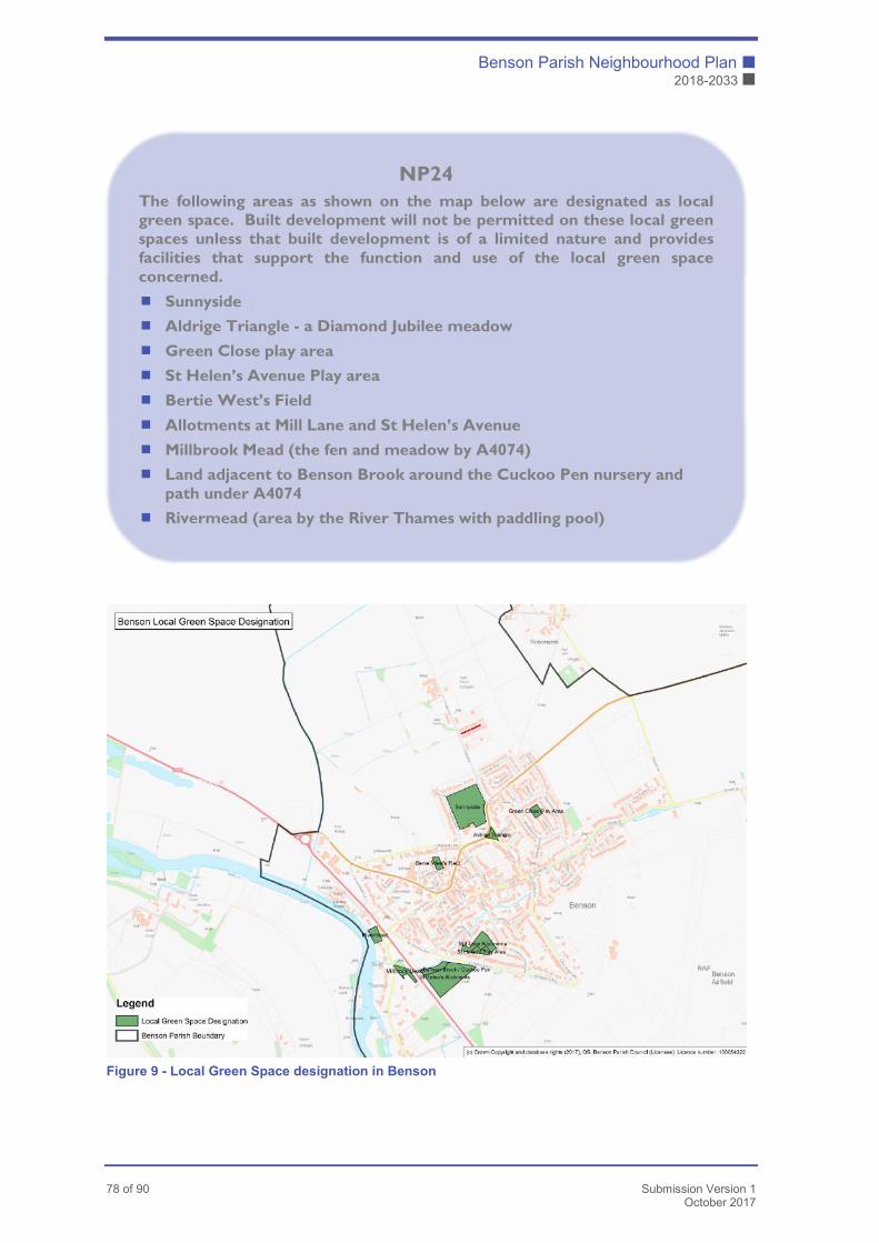
Benson Parish Neighbourhood Plan �
2018-2033 �
78 of 90 Submission Version 1
October 2017
Figure 9 - Local Green Space designation in Benson
NP24
The following areas as shown on the map below are designated as local green space. Built development will not be permitted on these local green spaces unless that built development is of a limited nature and provides facilities that support the function and use of the local green space concerned.
� Sunnyside
� Aldrige Triangle - a Diamond Jubilee meadow
� Green Close play area
� St Helen’s Avenue Play area
� Bertie West’s Field
� Allotments at Mill Lane and St Helen’s Avenue
� Millbrook Mead (the fen and meadow by A4074)
� Land adjacent to Benson Brook around the Cuckoo Pen nursery and path under A4074
� Rivermead (area by the River Thames with paddling pool)

� Benson Parish Neighbourhood Plan
� 2018-2033
Submission Version 1 79 of 90 October 2017
Creating New Green Spaces
14.9.3 The District Council’s Green Infrastructure Strategy (published March 2013 and
updated July 2013) identified a deficiency in Benson’s area of public parks and
gardens of 1.2 hectares for the size of population at 201112. A significant
increase in population will follow with the development of the strategic housing
sites identified earlier in this Plan. The District Council adopted standard of
provision for public green space in large villages is 1 ha per 1000 people within
1000m of all homes in the settlement.
14.9.4 Within this strategic context the Plan requires the provision of adequate
additional green space to take account of the increase in population resulting
from development.
14.9.5 Community consultation has advised that access to local open countryside is
important to residents of this parish both for recreation and for
pedestrian/cyclist access to other settlements. It also demonstrated that the
community values its connection with the River Thames. This Plan promotes
the use and enjoyment of the countryside both for its well-being benefits and to
encourage sustainable means of transport. New green spaces must connect
with existing green spaces and with the wider countryside.
14.9.6 New green space in the village is also proposed as mitigation for the additional
recreational disturbance at the nearby ‘honeypot’ European designated site at
Little Wittenham Special Area of Conservation generated by development in
Benson (as identified in initial screening against the ‘Habitats Regulations’ by
SODC). The green space needs to be of adequate scale and interest to offer a
reasonable alternative in order to serve as suitable mitigation. Thus two
substantial new areas of green space with suitable connections to wider
countryside are proposed to the north of the village as part of a new vegetated
edge (see Section 11.11.5)..
14.9.7 Public green spaces are often multifunctional and it is not always possible to
achieve all aims in the same green space. For example, allotments, whilst often
offering wildlife benefits if managed correctly tend not to be suitable for other
community uses. In addition, recreation is sometimes incompatible with the
needs of certain wildlife and meeting people’s needs for space for quiet
12 http://www.southoxon.gov.uk/services-and-advice/planning-and-building/planning-policy/evidence-
studies/evidence-base-revisions-j

Benson Parish Neighbourhood Plan �
2018-2033 �
80 of 90 Submission Version 1
October 2017
reflection. The new green spaces in Benson should be designed to meet a
range of distinct uses that are appropriate for the topography and the
ecological significance of each site.
Biodiversity – Nature in Benson
Context
14.10.1 Benson has much to cherish in its nature conservation assets. It is a parish
with a rural setting, and the presence of wildlife is a notable feature both within
and around the village. Herons and kingfishers fish along the chalk stream that
forms the spine of the village; tawny owls hoot in the evenings; swifts scream
and career over rooftops and pockets of natural green space support a
surprising diversity of butterflies and moths. Red kites soar overhead in
significant numbers, orchids appear in abundance in the village nature reserve
at Millbrook Mead and the fields surrounding the built settlements are important
for populations of farmland birds. Many of Benson’s residents take joy from
their day to day contact with wildlife.
14.10.2 Oxfordshire County Council’s ‘Oxfordshire Wildlife and Landscape Study’
(2014) makes specific recommendations for Benson. This plan takes account
of those that are relevant to planning in shaping the green infrastructure
commitments required where development is proposed:
� Ensure that all surviving ‘priority’ (i.e. those identified by the government as
being a priority for conservation action) habitats are safeguarded, in
favourable condition and management, and enhanced to satisfy the actions
and targets identified within the relevant habitat and species action plans.
NP25
New development should make appropriate provision of green space in accordance with South Oxfordshire District Council standards in place at the time of the determination of the application. The design of green spaces shall take account of the needs identified in Benson’s ‘People and Nature Strategy and this plan’s biodiversity policies, and must link where practicable via public footpaths to other public footpaths/bridleways connecting to the rest of the village and the wider countryside. Where possible, pedestrian links should be positioned to provide separation from road traffic.
� Benson Parish Neighbourhood Plan
� 2018-2033
Submission Version 1 81 of 90 October 2017
� Safeguard, maintain and enhance all locally important habitats in a way that
is appropriate to the landscape character of the area.
� Strengthen and enhance pattern of hedgerows, hedgerow trees and tree-
lined watercourse.
Summary of Assets
14.10.3 A comprehensive study of the natural environment assets in the parish,
‘Conservation Plan for the Parish of Benson, Oxfordshire13’, was compiled and
published in 2001 by the Benson Ecological Survey Team, (now known as
Benson Nature Group). A summary audit at Appendix K identifies the key
biodiversity assets in Benson and important features in the wider landscape
setting. The latter represent an important part of the wider green infrastructure
network, particularly when considering local recreation and wildlife needs.
14.10.4 The parish has no SSSIs or European Sites designated for wildlife interest.
Nevertheless, there are several specific areas of habitat within or adjacent to
the main built settlements that are of conservation interest. Ewelme Stream
(also known as Benson Brook), which forms the ‘spine’ of Benson village, is a
chalk stream, a globally endangered habitat, and a biodiversity and aesthetic
highlight. Populations of butterflies, including countryside species (as opposed
to garden species), are thriving (See Appendix K Part 4)
14.10.5 The Plan recognises Benson’s biodiversity assets. As the village grows, the
Plan policies seek to expand its ecological network, such that wildlife has the
opportunity to thrive and people have the opportunity to enjoy it. The plan aims
to secure built settlements that are ‘permeable’ to wildlife, connecting up green
spaces where possible, creating space for nature and enabling it to move
around. The Plan policies will:
i. protect existing assets, particularly trees, hedges and associated margins,
ii. influence the location and type (i.e. planting etc.) of green space secured
through development (See the Benson Design Statement at Appendix B
Section P) and
iii. require developers to build biodiversity enhancements into their
developments. In particular, the Plan seeks to provide wildlife corridors and
habitat for pollinators including butterflies and moths.
13 http://best.bensonbulletin.com/report/introduction.htm

Benson Parish Neighbourhood Plan �
2018-2033 �
82 of 90 Submission Version 1
October 2017
14.10.6 In support of biodiversity objectives, the Plan requires new paths to be
designed to perform as wildlife corridors as well as routes providing pedestrian
access. The Plan requires contributions from developers to fund the
maintenance of green infrastructure within developments for an appropriate
period.
NP26
Development proposals should maintain and enhance existing on-site biodiversity assets, delivering ‘net gain’ in line with the District Council’s core strategy, and provide for wildlife needs on site, where possible. For smaller sites, a contribution to biodiversity enhancement elsewhere in the parish may be made.
On-site biodiversity enhancements such as new roosting features for bats or nesting features for birds should be incorporated into the fabric of the development (See Appendix L – Benson’s Strategy for People and Nature).
NP27
Proposals for new residential development should provide wildlife corridors that allow wildlife to move from one area of habitat to another.
The green space and landscape buffers provided through development and related planting schemes should, where ecologically appropriate to do so, reflect the locally-specific aims set out in Benson’s Strategy for People and Nature [See Appendix L]. Where ecologically relevant, fences and walls should be designed to incorporate features that allow dispersal of wildlife through areas of green space and gardens.
� Benson Parish Neighbourhood Plan
� 2018-2033
Submission Version 1 83 of 90 October 2017
Landscape Setting and Character
14.11.1 Benson is a managed rural landscape, with a mixture of agricultural, military,
and small-scale commercial uses, and a number of built settlements of historic
interest. To the west, the parish borders the river with low lying meadows.
Further meadows, visible beyond the far bank, draw the eye into the North
Wessex Downs Area of Outstanding Natural Beauty. North of the village, the
land is flat and open, with fields extending towards Warborough, and paths
providing very wide landscape views. An operational RAF airfield occupies the
centre of the parish, but the bulk of it remains green and open. Beyond to the
south-east, fields slope upwards towards the chalk scarp of the Chiltern Hills
and some small patches of woodland. This south-eastern part of the parish lies
within the Chiltern Hills Area of Outstanding Natural Beauty.
Distinctiveness of Settlements
14.11.2 Within this landscape, the hamlets of Preston Crowmarsh to the south-west and
Rokemarsh to the north-east on the border of Berrick Salome Parish are
separate rural settlements, distinct from Benson village. The open agricultural
NP29
Development proposals should be planned and executed so as to avoid deterioration in the ecological status of the main watercourses of the River Thames, Ewelme Stream (Benson Brook) and Elm Brook (also known as Berrick Stream and Lady Brook).
Development should retain or provide a buffer adjacent to the watercourse of natural or semi-natural habitat, free from built development, parking areas, private gardens and formal landscaping.
NP28
Development proposals required to provide on-site green infrastructure must provide Green Infrastructure management plans, with funding for a 15 year period to ensure the establishment of long-term management of the assets.
Benson Parish Neighbourhood Plan �
2018-2033 �
84 of 90 Submission Version 1
October 2017
land or green space between these hamlets and Benson is important to their
rural setting and separate identity, as well as to the rural character of the area
and the setting of the AONBs. This plan therefore requires that development
shall retain rural landscape space between the settlements adequate to
maintain this distinction and character.
Important Views
14.11.3 There are a number of views from public vantage points that are particularly
distinctive of the rural landscape setting, the village lying low within it, and the
context of the two AONBs, and the Plan requires that development proposals
recognise and take account of these. These views are identified on the map
below Figure 10 (see also Appendix E for photographs) and have been
grouped according to their relevance to the plan:
Group A - The association between Benson, Preston Crowmarsh and the River Thames, as relevant to design principles for any future development of the riverside.
View 1. View from Benson Lock towards St Helen’s Church;
View 2. Seasonal views from the Thames Path towards the historic settlement at Preston Crowmarsh;
Group B - Views out from the village showing the village’s connection with the wider landscape
View 3. the views from the end of Hale Road/Lane towards the North Wessex Downs AONB, specifically the Sinodun Hills (including the Wittenham Clumps) and beyond towards Warborough;
View 4. View from the footpath behind Blacklands Road, south east towards Brook Street and the Chiltern Hills beyond;
View 5. Views from Preston Crowmarsh across the river, towards the river meadows and the North Wessex Downs AONB;
NP30
Development should maintain adequate open landscape space, rural in character, between Benson and other neighbouring settlements to allow perception and experience of the settlements in the area as separate, distinct and rural.
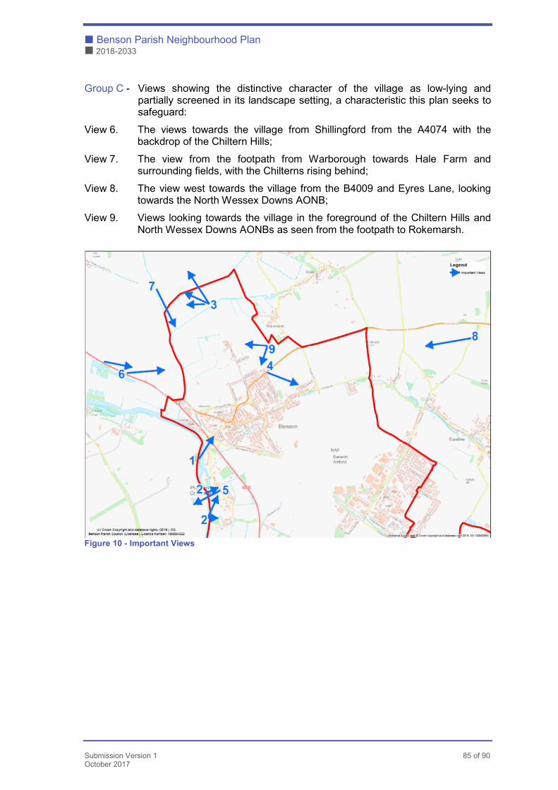
� Benson Parish Neighbourhood Plan
� 2018-2033
Submission Version 1 85 of 90 October 2017
Group C - Views showing the distinctive character of the village as low-lying and partially screened in its landscape setting, a characteristic this plan seeks to safeguard:
View 6. The views towards the village from Shillingford from the A4074 with the backdrop of the Chiltern Hills;
View 7. The view from the footpath from Warborough towards Hale Farm and surrounding fields, with the Chilterns rising behind;
View 8. The view west towards the village from the B4009 and Eyres Lane, looking towards the North Wessex Downs AONB;
View 9. Views looking towards the village in the foreground of the Chiltern Hills and North Wessex Downs AONBs as seen from the footpath to Rokemarsh.
Figure 10 - Important Views
Benson Parish Neighbourhood Plan �
2018-2033 �
86 of 90 Submission Version 1
October 2017
Scope for development
14.11.4 The Landscape Capacity Assessment14 for sites on the edge of the larger
villages in South Oxfordshire (conducted on behalf of the District Council in
2014) considered the landscape impacts of the then eight potential
development sites around Benson. Although the parish’s main settlements
(Benson and Preston Crowmarsh) lie outside the AONB boundaries, the
assessment noted their proximity and thus the potential for harm through
‘unsympathetic incremental expansion of the settlements of and adjacent to the
North Wessex Downs AONB, detracting from the surrounding countryside’.
This Landscape Capacity Assessment ruled out development of the site to the
north east of the village due to the risk of coalescence with Rokemarsh, but
concluded that some development would be possible on some of the other
seven sites considered at the time, subject to mitigation to take account of
landscape and visual constraints. The housing allocation described in Section 6
however recognises the importance of a relief road in order to support
sustainable development in Benson, the only feasible route for which involves
development to the north east of the village. The Plan therefore addresses the
need for landscape mitigation to offset the impacts of development.
14.11.5 Taking into account all of the needs outlined in the Green Space and
Landscape Character sections above, and in the light of more recent planning
permissions, this plan prioritises the creation of a substantial new
multifunctional vegetated edge, to include local native trees and hedging,
around the extended settlement. This meets multiple aims including:
14
https://consult.southandvale.gov.uk/portal/south/planning/pol/lp2031/ro/south_oxfordshire_landscape_assessment
_part_one
NP31
Development proposals should take account of the important views shown on Figure 10.
Planning applications should be accompanied with the necessary technical information to demonstrate how the proposal has incorporated the Design Principles A1-6 and C1-7 in the Benson Design Statement to mitigate any potential or identified harmful effects.

� Benson Parish Neighbourhood Plan
� 2018-2033
Submission Version 1 87 of 90 October 2017
� maintaining the distinction between Benson, Rokemarsh and Preston
Crowmarsh, guarding against coalescence of settlements by providing open
rural landscape between them to ensure they remain separate;
� providing a permeable green vegetated buffer between development and
the wider landscape, one that allows for a connection between the two but
softening hard edges and breaking up the visual impact of new built mass
on the fringes of the village so as to respect the setting and the context of
the two AONBs;
� contributing to reducing the identified shortfall in open accessible public
green space, providing for the community’s needs for recreation and space
for nature, whilst also mitigating visitor pressure on European protected sites
in the vicinity;
� providing new public rights of way, linking to the wider footpath network;
� creating links to existing Green Infrastructure features i.e. the Thames Path.
This will align with our built design policies which seek to avoid harmful impacts
of development on important views.
NP32
Development proposals should respect the rural character and setting of the village by incorporating a vegetated landscape buffer of an appropriate depth to take account of the topography of the site and its location within the village to include local native trees and hedging, around the outer edge where development meets and connects with the rural landscape.
The landscape buffer concerned should be designed so as to accommodate appropriate habitats for wildlife (as guided by the Benson Strategy for People and Nature and the principles in the Benson Design Statement) and suitable pedestrian access connected to the wider footpath network, and maintaining separation where possible between traffic and pedestrians / cyclists.
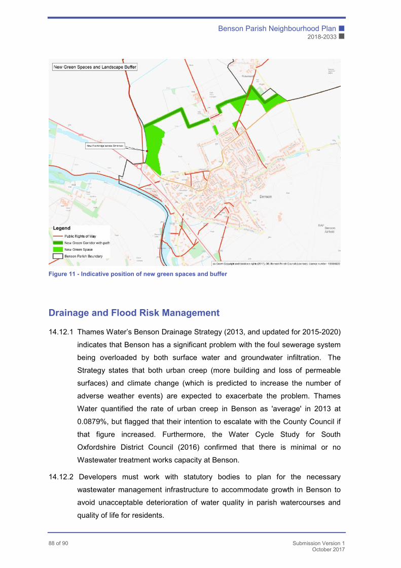
Benson Parish Neighbourhood Plan �
2018-2033 �
88 of 90 Submission Version 1
October 2017
Figure 11 - Indicative position of new green spaces and buffer
Drainage and Flood Risk Management
14.12.1 Thames Water’s Benson Drainage Strategy (2013, and updated for 2015-2020)
indicates that Benson has a significant problem with the foul sewerage system
being overloaded by both surface water and groundwater infiltration. The
Strategy states that both urban creep (more building and loss of permeable
surfaces) and climate change (which is predicted to increase the number of
adverse weather events) are expected to exacerbate the problem. Thames
Water quantified the rate of urban creep in Benson as 'average' in 2013 at
0.0879%, but flagged that their intention to escalate with the County Council if
that figure increased. Furthermore, the Water Cycle Study for South
Oxfordshire District Council (2016) confirmed that there is minimal or no
Wastewater treatment works capacity at Benson.
14.12.2 Developers must work with statutory bodies to plan for the necessary
wastewater management infrastructure to accommodate growth in Benson to
avoid unacceptable deterioration of water quality in parish watercourses and
quality of life for residents.
� Benson Parish Neighbourhood Plan
� 2018-2033
Submission Version 1 89 of 90 October 2017
14.12.3 Flows in Benson Brook are influenced by the level of winter rainfall infiltrating
down into the chalk aquifer and flowing out from late winter onwards, mainly
entering the brook in a series of springs in Ewelme. During periods of peak
flow, some residents along Brook Street report water rising up through their
floors.
14.12.4 Developers must take account of these specific flood risks in Benson and avoid
exacerbating the issue by providing adequate on-site drainage proposals. The
detail of Sustainable Drainage System proposals must take account of advice
from RAF Benson on the need to manage the risk of bird strike.
Note on Agriculture
14.13.1 Benson is a rural parish and agriculture plays a significant part in its land use.
There is a strong link between how agriculture is undertaken and the
achievement of good environmental outcomes, but this generally falls outside
the scope of neighbourhood planning. Benson’s Strategy for People and
Nature considers opportunities to work with local farmers to further its aims and
objectives.
NP33
Development proposals should include Sustainable Drainage Systems within their boundaries designed to manage the risk of surface water flooding and foul water sewer overload, and that they will not increase flood risk elsewhere in Benson.
Sustainable Drainage Systems should be designed to maximise the benefits of the features, taking account where possible of the Benson’s Strategy for Nature and People (See Appendix L).
NP34
Built development within areas which provide flood capacity for the built settlements will not be supported.

Benson Parish Neighbourhood Plan �
2018-2033 �
90 of 90 Submission Version 1
October 2017
15. Appendices
Appendix A – Sites Assessment
Appendix B – Design Statement
Appendix C – Heritage Study
Appendix D – Community Questionnaire Report
Appendix E – Character Assessment
Appendix F – Transport Assessment
Appendix F1 – Traffic Pinch Points
Appendix F2 – Traffic Flow Summary
Appendix F3 – Local Development Sites
Appendix F4 – Watlington Road Traffic Growth
Appendix F5 – Traffic Data
Appendix F6 – Flood Zone Assessment
Appendix G – Parking Plan
Appendix H – Map of Sustainable Transport
Appendix I – Community Facilities
Appendix J – Parish Allotment Usage Data
Appendix K – Green Infrastructure & Biodiversity Audit
Appendix K1 – Local Green Space Designation
Appendix K2 – Benson’s Green Infrastructure Assets
Appendix K3 – TVERC Biodiversity Report for Benson
Appendix K4 – Benson Nature Group Butterfly Survey
Appendix K5 – Butterfly Conservation Priorities Advice
Appendix L – Benson’s Strategy for People and Nature
Recommended