Page 0
lR;eso t;rs
Government of India
Ministry of MSME
Brief Industrial Profile of Sagar District
Madhya Pradesh Updated in the year
2015-16
Carried out by
M S ME - D e v e lo p me n t I n s t i tu t e I n do r e (Ministry of MSME, Govt. of India,)
Phone: 0731-2421037, 540
Fax: 0731- 2420723, 540
E-mail: [email protected]
Web- www.msmeindore.nic.in
Page 1
Foreword In response to letter no. 1/7/DIP/2015/MSME-DI dated 20/05/2016 of O/o DC
(MSME), M/o MSME, Govt. of India. The District Industrial Profile of -Sagar for
the year 2015-16 has been updated upto 31/03/2016 by this office. This profile
contained Geography, Topography, Mineral availability, forest resources, District
general information, Industrial scenario & potentiality of MSME of the district.
The district of Sagar lies in the north central region of Madhya Pradesh. It was
spelled as Saugar during the British period. It is situated between 23°10’ and
24°27’ north latitude and between 78° 4’ and 79 ° 21’ east longitude; the district
has a truly central location in the country. The tropic of cancer passes through the
southern part of the district. The origin of the name comes from the Hindi word
Sagar meaning lake or sea, apparently because of the large and once beautiful lake
around which the town of Sagar has been built. Sagar was founded by Udan Singh
in 1660 and was constituted a municipality in 1867. A major road and agricultural
trade centre, it has industries such as oil and flour milling, saw-milling , ghee
processing , handloom cotton weaving, bidi manufacture and railway and
engineering works. It is known in all over India due to its University named as Dr.
Harisingh Gaur University and Army Cantonment and recently it has come into
lime light due to Bhagyodyay Tirth a charitable hospital named after a Jain Sant
Shri Vidya Sagarji Maharaj. It is known that the Police Training College which is
only two in Madhya Pradesh other one is in Indore. Head quarter of Forensic
Science Lab is also in Sagar. General Bo
While preparing the profile, the data was collected from various departments of
Madhya Pradesh Government and from internet. I take this opportunity to
appreciate the efforts of Shri V.M.Kshire, Asstt. Director (PI), Shri Madhukar
Sharma, Asstt. Director (EI) in bringing out this industrial profile of Sagar for the
year 2015-16.
(Pradeep Kumar)
Director
Page 2
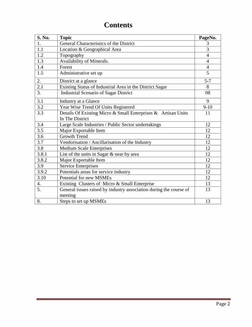
Contents
S. No. Topic PageNo.
1. General Characteristics of the District 3
1.1 Location & Geographical Area 3
1.2 Topography 4
1.3 Availability of Minerals. 4
1.4 Forest 4
1.5 Administrative set up 5
2. District at a glance 5-7
2.1 Existing Status of Industrial Area in the District Sagar 8
3. Industrial Scenario of Sagar District 08
3.1 Industry at a Glance 9
3.2 Year Wise Trend Of Units Registered 9-10
3.3 Details Of Existing Micro & Small Enterprises & Artisan Units
In The District
11
3.4 Large Scale Industries / Public Sector undertakings 12
3.5 Major Exportable Item 12
3.6 Growth Trend 12
3.7 Vendorisation / Ancillarisation of the Industry 12
3.8 Medium Scale Enterprises 12
3.8.1 List of the units in Sagar & near by area 12
3.8.2 Major Exportable Item 12
3.9 Service Enterprises 12
3.9.2 Potentials areas for service industry 12
3.10 Potential for new MSMEs 12
4. Existing Clusters of Micro & Small Enterprise 13
5. General issues raised by industry association during the course of
meeting
13
8. Steps to set up MSMEs 13
Page 3
Brief Industrial Profile of Sagar District
1. General Characteristics of the District:
The district of Sagar lies in the north central region of Madhya Pradesh. It was spelled as
Saugar during the British period. It is situated between 23°10’ and 24°27’ north latitude and
between 78° 4’ and 79 ° 21’ east longitude; the district has a truly central location in the
country. The tropic of cancer passes through the southern part of the district. The origin of
the name comes from the Hindi word Sagar meaning lake or sea, apparently because of the
large and once beautiful lake around which the town of Sagar has been built. Sagar was
founded by Udan Singh in 1660 and was constituted a municipality in 1867. A major road
and agricultural trade centre, it has industries such as oil and flour milling, saw-milling , ghee
processing , handloom cotton weaving, bidi manufacture and railway and engineering works.
It is known in all over India due to its University named as Dr. Harisingh Gaur University
and Army Cantonment and recently it has come into lime light due to Bhagyodyay Tirth a
charitable hospital named after a Jain Sant Shri Vidya Sagarji Maharaj. It is known that the
Police Training College which is only two in Madhya Pradesh other one is in Indore. Head
quarter of Forensic Science Lab is also in Sagar. General Bo
1.1 Location & Geographical Area:
The district is situated on the north by Jhansi district of Uttar Pradesh, on the south by the
district of Narsinghpur and Raisen, on the west by the district of Vidisha , and on the east by
the district of Damoh, which was previously formed the part of Sagar District. On the noth-
east and north-west, the district adjoins Chhattarpur and Guna districts, respectively. The
district is accessible by rail as the town of Sagar lies on the Bina Katni branch line of Centra
railway. Sagar is 76 Km from Bina which is on the Bombay Delhi main line. The district is
traversed by first class roads which connect it with important towns like Damoh and Jabalpur
on the east and south east, respectively, Lalitpur and Jhansi on the north, Chhattarpur on the
north east and Bhopal on the south-west. Bhopal the capital of Madhya Pradesh is about 208
Km from Sagar by road. According to the Surveyor-General of India, the district has a total
area of 6375 sq Kms and is shaped roughly like a triangle. The geographical area of Sagar
district is 1022.80 hectare.

Page 4
1.2 Topography:
Sagar lies in an extensive plain broken by low, forested hills and watered by Sonar river.
Wheat, chickpeas, soghum, and oilseeds are chief crops of the region, there is extensive cattle
raising. Sandstone, Limestone, iron ore and asbestos deposits are worked. The archaeological
site nearby Eran has revealed several Gupta inscriptions. District Sagar is predominantly a
Scheduled Caste/Backward class district. These together form about 75% of the district. The
district has sizable population of tribals who are named as Rajgonds after their kingdom.
1.3 Availability of Minerals. PRODUCTION OF MINERAL 2014-15
S.NO. NAME OF MINERAL PRODUCTION in tones
MAJOR MINERAL
1. Dolomite 3938.41
2. Iron-ore 22564.30
3. Clay 06481.185
5. Rock-phosphate 32086.85
Total 65070.745
MINOR
S.NO. NAME OF MINERAL PRODUCTION ( in Cu.
Meter)
1. Stone {Flag} 18736.28
2. Stone crushed 471816.00
3. Stone boulder 1367829.40
4. Sand 47017.00
5. Murom 451603.66
Total 2357002.34
SOURCE:- DTIC, Sagar
1.4 Forest:
Forest area of the district is as 1,065.35 sq. miles consisting of 739.80 sq. miles of 'Reserved'
forests and 325.55 sq. miles of 'Protected' forests, an area of about 92 sq. miles of forests is
under the control of the Revenue Department.
Page 5
1.5 Administrative set up.
Sagar district is the sixteenth largest district in size in the State, and the third largest in the
Jabalpur revenue division. The district is divided into nine tahsils, viz, Banda, Sagar, Khurai,
Garhakota, Bina, Deori, Rehli, Rahatgarh and Kesli each in the charge of a Tehsildar or a Sub-
Divisional Officer.Commissioner. There are 11 blocks, 05 Nagar Palika, 11 Janpad panchayats,
01 Jila Panchayat ,753 Village Panchayats, 2076 Villages, 2059 Revenue Villages, & 1901
Developed Villages in whole district. The position of officer in the Sagar district like that
Inspector General of Police, District Magistrate, District Judge, Additional Collector, CEO Jila
Panchayat, Superintendent of Police, District Women and Child Development, District Food
Officer, Planning Officer, Superintendent Land Record, District Registrar, SP Lokayukta,
Income Tax Officer, SDM at Sagar, Bina Khurai, Banda, Rahatgarh, Deori & Rehli Tehsils.
Tehsildar at Sagar, Bina Khurai, Malthone Shagarh, Banda, Rahatgarh, Deori, Rehli, Tehsils,
Kesli & Garhakota.
2. District at a glance
S.No Particular Year Unit Statistics
1 Geographical features
(A) Geographical Data latitude and
between longitude,
i) Latitude 23°10’ N- 24°27’ N
ii) Longitude 78° 4’ E 79 ° 21 E’
iii) Geographical Area Hectares
1025200
(B) Administrative Units
i) Sub divisions 2015 Nos. --
ii) Tehsils 2015 Nos. 11
iii) Sub-Tehsil 2015 Nos. --
iv) Patwar Circle 2015 Nos. 395
v) Panchayat Simitis 2015 Nos. 760
vi)Nagar Nigam 2015 Nos. 01
vii) Nagar Palika 2015 Nos. 05
viii) Gram Panchayats 2015 Nos. 753
xi) Revenue villages 2015 Nos. 2059
x) Assembly Area 2015 Nos. 08
2. Population
(A) Sex-wise
i) Male 2015 Nos. 1073205
ii) Female 2015 Nos. 948782
Page 6
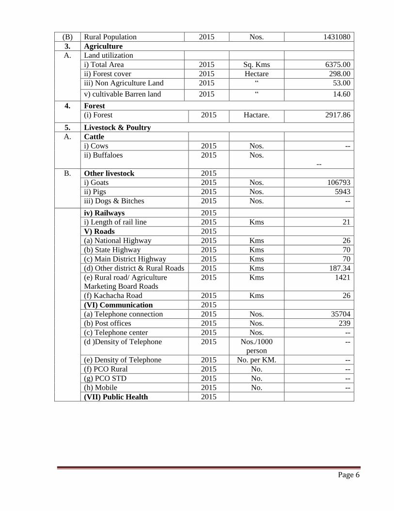
(B) Rural Population 2015 Nos. 1431080
3. Agriculture
A. Land utilization
i) Total Area 2015 Sq. Kms 6375.00
ii) Forest cover 2015 Hectare 298.00
iii) Non Agriculture Land 2015 “ 53.00
v) cultivable Barren land 2015 “ 14.60
4. Forest
(i) Forest 2015 Hactare. 2917.86
5. Livestock & Poultry
A. Cattle
i) Cows 2015 Nos. --
ii) Buffaloes 2015 Nos.
--
B. Other livestock 2015
i) Goats 2015 Nos. 106793
ii) Pigs 2015 Nos. 5943
iii) Dogs & Bitches 2015 Nos. --
iv) Railways 2015
i) Length of rail line 2015 Kms 21
V) Roads 2015
(a) National Highway 2015 Kms 26
(b) State Highway 2015 Kms 70
(c) Main District Highway 2015 Kms 70
(d) Other district & Rural Roads 2015 Kms 187.34
(e) Rural road/ Agriculture
Marketing Board Roads
2015 Kms 1421
(f) Kachacha Road 2015 Kms 26
(VI) Communication 2015
(a) Telephone connection 2015 Nos. 35704
(b) Post offices 2015 Nos. 239
(c) Telephone center 2015 Nos. --
(d )Density of Telephone 2015 Nos./1000
person
--
(e) Density of Telephone 2015 No. per KM. --
(f) PCO Rural 2015 No. --
(g) PCO STD 2015 No. --
(h) Mobile 2015 No. --
(VII) Public Health 2015
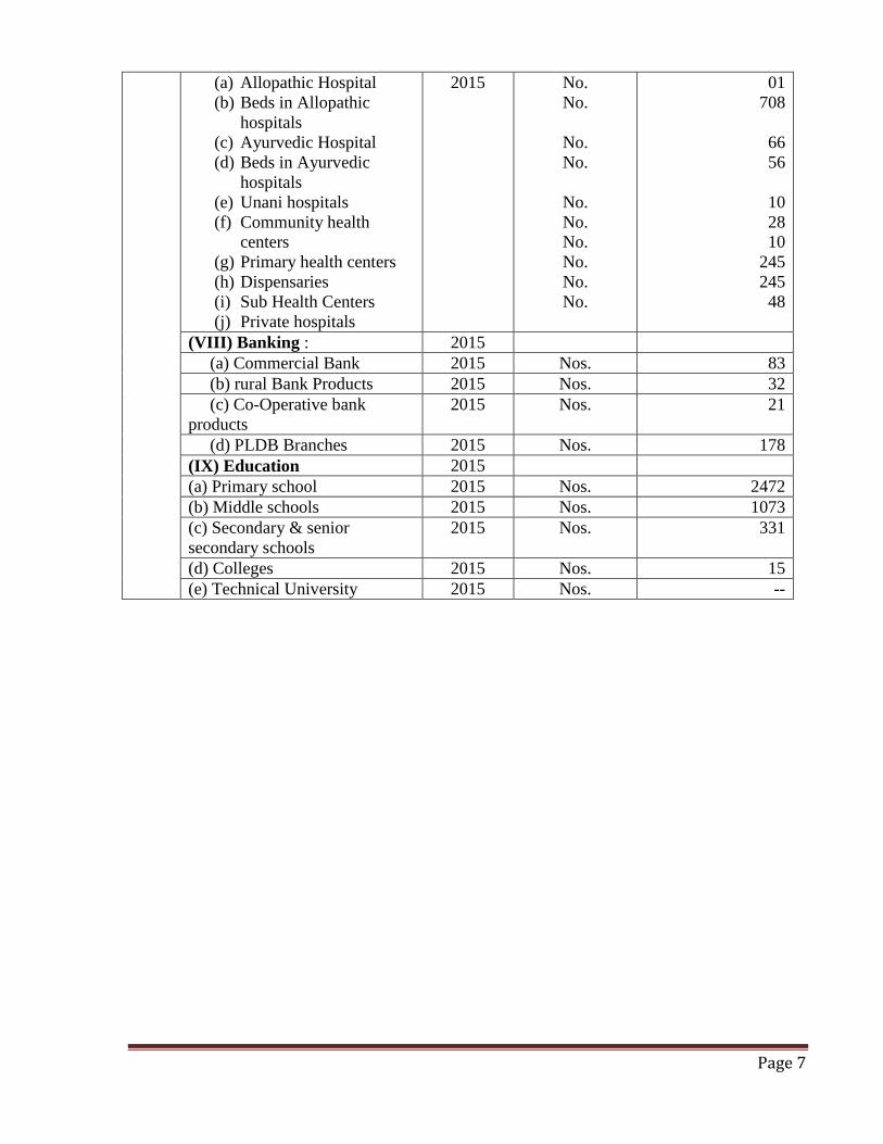
Page 7
(a) Allopathic Hospital
(b) Beds in Allopathic
hospitals
(c) Ayurvedic Hospital
(d) Beds in Ayurvedic
hospitals
(e) Unani hospitals
(f) Community health
centers
(g) Primary health centers
(h) Dispensaries
(i) Sub Health Centers
(j) Private hospitals
2015 No.
No.
No.
No.
No.
No.
No.
No.
No.
No.
01
708
66
56
10
28
10
245
245
48
(VIII) Banking : 2015
(a) Commercial Bank 2015 Nos. 83
(b) rural Bank Products 2015 Nos. 32
(c) Co-Operative bank
products
2015 Nos. 21
(d) PLDB Branches 2015 Nos. 178
(IX) Education 2015
(a) Primary school 2015 Nos. 2472
(b) Middle schools 2015 Nos. 1073
(c) Secondary & senior
secondary schools
2015 Nos. 331
(d) Colleges 2015 Nos. 15
(e) Technical University 2015 Nos. --
Page 8
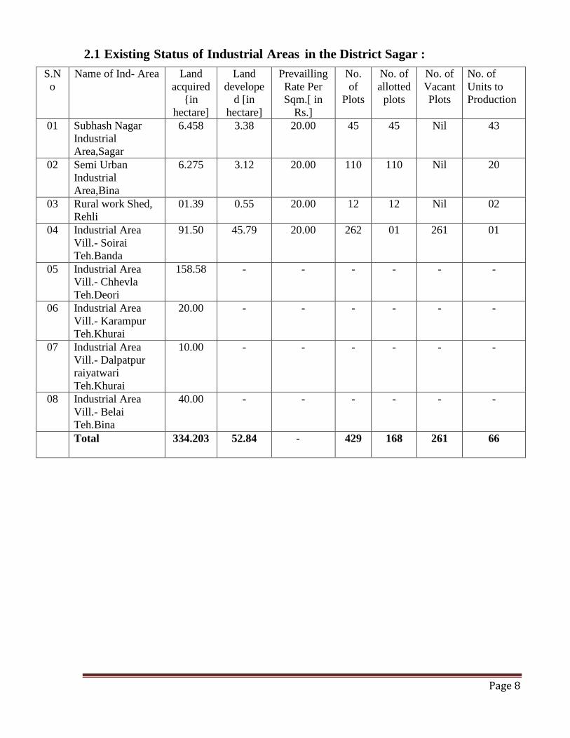
2.1 Existing Status of Industrial Areas in the District Sagar :
S.N
o
Name of Ind- Area Land
acquired
{in
hectare]
Land
develope
d [in
hectare]
Prevailling
Rate Per
Sqm.[ in
Rs.]
No.
of
Plots
No. of
allotted
plots
No. of
Vacant
Plots
No. of
Units to
Production
01 Subhash Nagar
Industrial
Area,Sagar
6.458 3.38 20.00 45 45 Nil 43
02 Semi Urban
Industrial
Area,Bina
6.275
3.12 20.00 110 110 Nil 20
03 Rural work Shed,
Rehli
01.39
0.55 20.00 12 12 Nil 02
04 Industrial Area
Vill.- Soirai
Teh.Banda
91.50 45.79 20.00 262 01 261 01
05 Industrial Area
Vill.- Chhevla
Teh.Deori
158.58 - - - - - -
06 Industrial Area
Vill.- Karampur
Teh.Khurai
20.00 - - - - - -
07 Industrial Area
Vill.- Dalpatpur
raiyatwari
Teh.Khurai
10.00 - - - - - -
08 Industrial Area
Vill.- Belai
Teh.Bina
40.00 - - - - - -
Total
334.203 52.84 - 429 168 261 66
Page 9
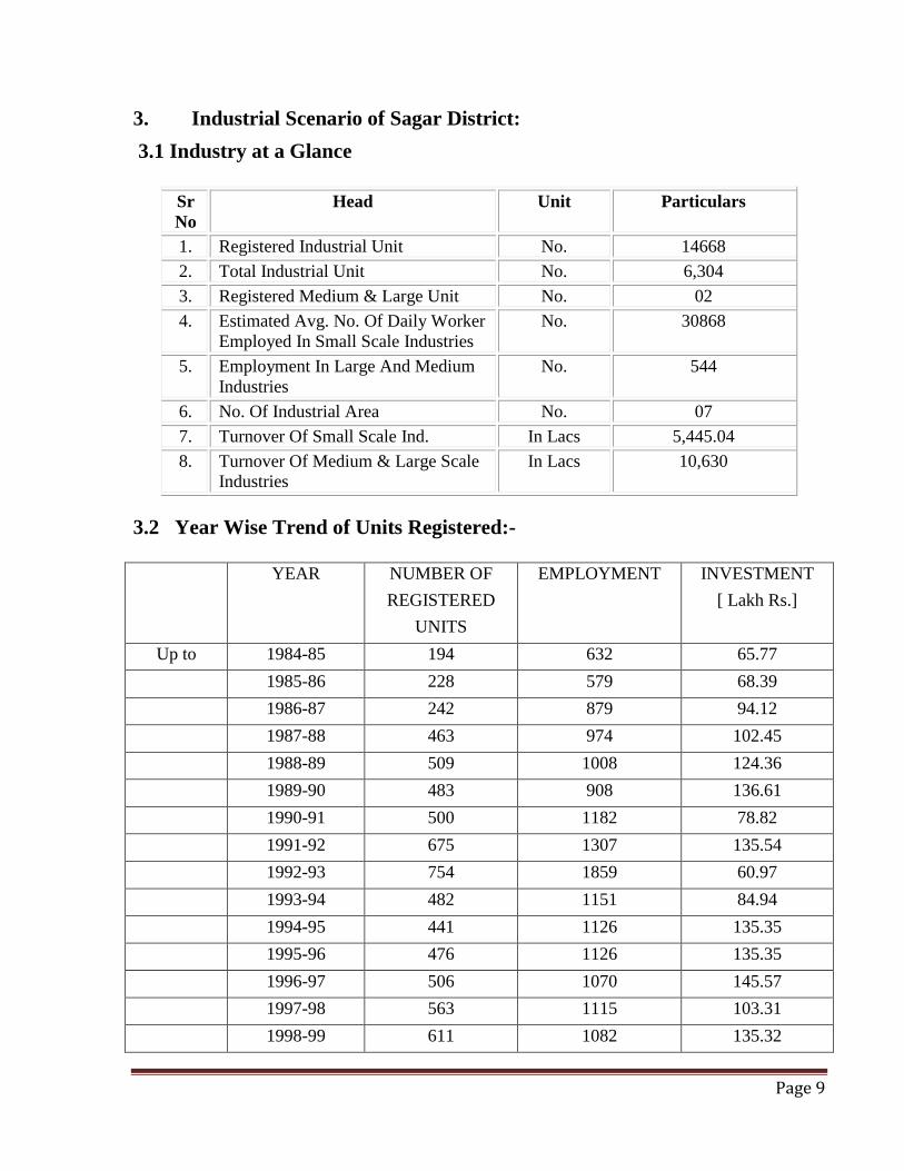
3. Industrial Scenario of Sagar District:
3.1 Industry at a Glance
Sr
No
Head Unit Particulars
1. Registered Industrial Unit No. 14668
2. Total Industrial Unit No. 6,304
3. Registered Medium & Large Unit No. 02
4. Estimated Avg. No. Of Daily Worker
Employed In Small Scale Industries
No. 30868
5. Employment In Large And Medium
Industries
No. 544
6. No. Of Industrial Area No. 07
7. Turnover Of Small Scale Ind. In Lacs 5,445.04
8. Turnover Of Medium & Large Scale
Industries
In Lacs 10,630
3.2 Year Wise Trend of Units Registered:-
YEAR NUMBER OF
REGISTERED
UNITS
EMPLOYMENT INVESTMENT
[ Lakh Rs.]
Up to 1984-85 194 632 65.77
1985-86 228 579 68.39
1986-87 242 879 94.12
1987-88 463 974 102.45
1988-89 509 1008 124.36
1989-90 483 908 136.61
1990-91 500 1182 78.82
1991-92 675 1307 135.54
1992-93 754 1859 60.97
1993-94 482 1151 84.94
1994-95 441 1126 135.35
1995-96 476 1126 135.35
1996-97 506 1070 145.57
1997-98 563 1115 103.31
1998-99 611 1082 135.32
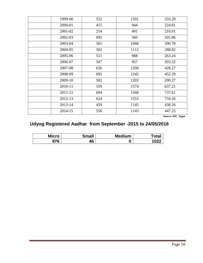
Page 10
1999-00 552 1501 333.29
2000-01 415 944 224.81
2001-02 214 491 210.01
2002-03 095 360 205.86
2003-04 501 1068 390.78
2004-05 502 1112 288.82
2005-06 511 988 263.24
2006-07 507 957 203.32
2007-08 626 1206 428.27
2008-09 695 1245 452.29
2009-10 582 1202 200.27
2010-11 559 1574 637.21
2011-12 604 1568 737.61
2012-13 624 1553 734.26
2013-14 459 1145 438.26
2014-15 556 1143 447.25
Source: DIC Sagar
Udyog Registered Aadhar from September -2015 to 24/05/2016
Micro Small Medium Total
976 46 0 1022
Page 11
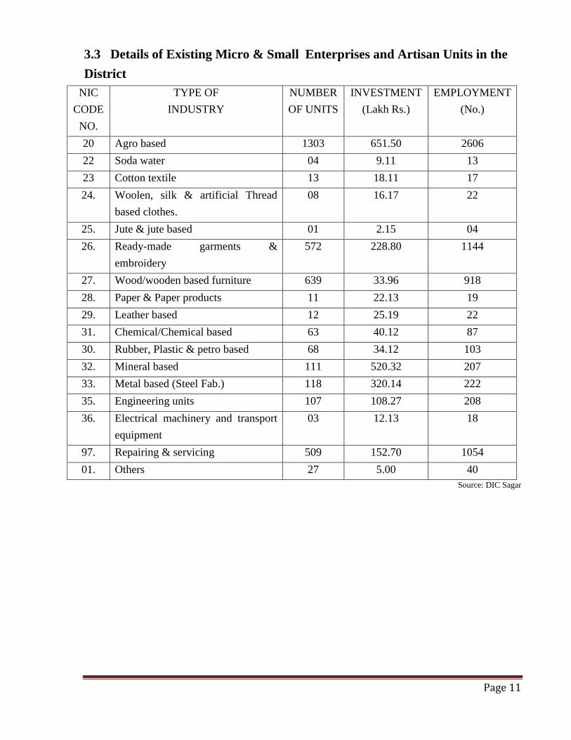
3.3 Details of Existing Micro & Small Enterprises and Artisan Units in the
District
NIC
CODE
NO.
TYPE OF
INDUSTRY
NUMBER
OF UNITS
INVESTMENT
(Lakh Rs.)
EMPLOYMENT
(No.)
20 Agro based 1303 651.50 2606
22 Soda water 04 9.11 13
23 Cotton textile 13 18.11 17
24. Woolen, silk & artificial Thread
based clothes.
08 16.17 22
25. Jute & jute based 01 2.15 04
26. Ready-made garments &
embroidery
572 228.80 1144
27. Wood/wooden based furniture 639 33.96 918
28. Paper & Paper products 11 22.13 19
29. Leather based 12 25.19 22
31. Chemical/Chemical based 63 40.12 87
30. Rubber, Plastic & petro based 68 34.12 103
32. Mineral based 111 520.32 207
33. Metal based (Steel Fab.) 118 320.14 222
35. Engineering units 107 108.27 208
36. Electrical machinery and transport
equipment
03 12.13 18
97. Repairing & servicing 509 152.70 1054
01. Others 27 5.00 40
Source: DIC Sagar
Page 12
3.4 Large Scale Industries / Public Sector undertakings
3.4.1 List of the units in Sagar & near by area Sagar district,
1. M/s. Bina Refinery
village- Agasoid, Teh.-Bina, Disstt- Sagar (PSU).
3.5 Major Exportable Item: There are no such types of unit engaged for product
exportable.
3.6 Growth Trend: 4-5%
3.7 Vendorisation / Ancillarisation of the Industry : There is no such type of unit
exist for Vendorisation / Ancillarisation.
3.8. Medium Scale Enterprises
3.8.1 List of the units in Raisen & Near By Area: Not available by DTIC, Sagar.
3.9 Service Enterprises:
Steel fabrication, instrumentation services, T.V Servicing, Welding woks, Photocopy Servicing, Radio
Servicing, Motor binding & Computer Hardware Servicing, Mobile Repairing, Engg. Workshop,
Electrical Appliances Repairing, Scooter Repairing, Cycle Repairing, Beauty Parlor & Tractor Servicing
etc.
3.9.2 Potentials areas for service industry: Sagar, Kesli, Bina, Khurai & banda blocks of Sagar district’s are potential areas for service industry.
3.10 Potential for new MSMEs : Oil expeller, Spices grinding, bakery products, footwear, leather bags, plastic products , Bidi
mfg., clay bricks mfg. , aggregate mfg. stone crusher, stone statue & toys, RCC pipes, detergent
soap/ powder, petrochemicals, packing materials Readymade Garment & embroidery, Solvant
/oil pant, leather products & flour mill etc.
Page 13
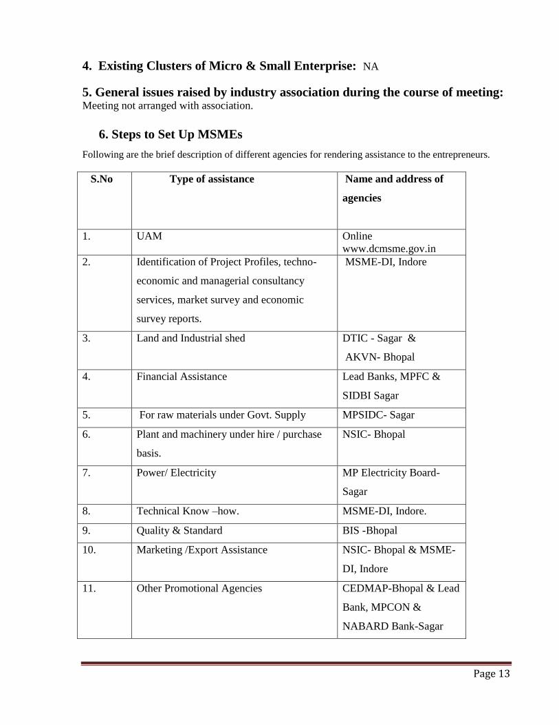
4. Existing Clusters of Micro & Small Enterprise: NA
5. General issues raised by industry association during the course of meeting: Meeting not arranged with association.
6. Steps to Set Up MSMEs
Following are the brief description of different agencies for rendering assistance to the entrepreneurs.
S.No
Type of assistance Name and address of
agencies
1. UAM Online
www.dcmsme.gov.in
2. Identification of Project Profiles, techno-
economic and managerial consultancy
services, market survey and economic
survey reports.
MSME-DI, Indore
3. Land and Industrial shed DTIC - Sagar &
AKVN- Bhopal
4. Financial Assistance Lead Banks, MPFC &
SIDBI Sagar
5. For raw materials under Govt. Supply MPSIDC- Sagar
6. Plant and machinery under hire / purchase
basis.
NSIC- Bhopal
7. Power/ Electricity MP Electricity Board-
Sagar
8. Technical Know –how. MSME-DI, Indore.
9. Quality & Standard BIS -Bhopal
10. Marketing /Export Assistance NSIC- Bhopal & MSME-
DI, Indore
11. Other Promotional Agencies CEDMAP-Bhopal & Lead
Bank, MPCON &
NABARD Bank-Sagar
Recommended