CITY OF DAVIS BICYCLE PLAN
2009
2
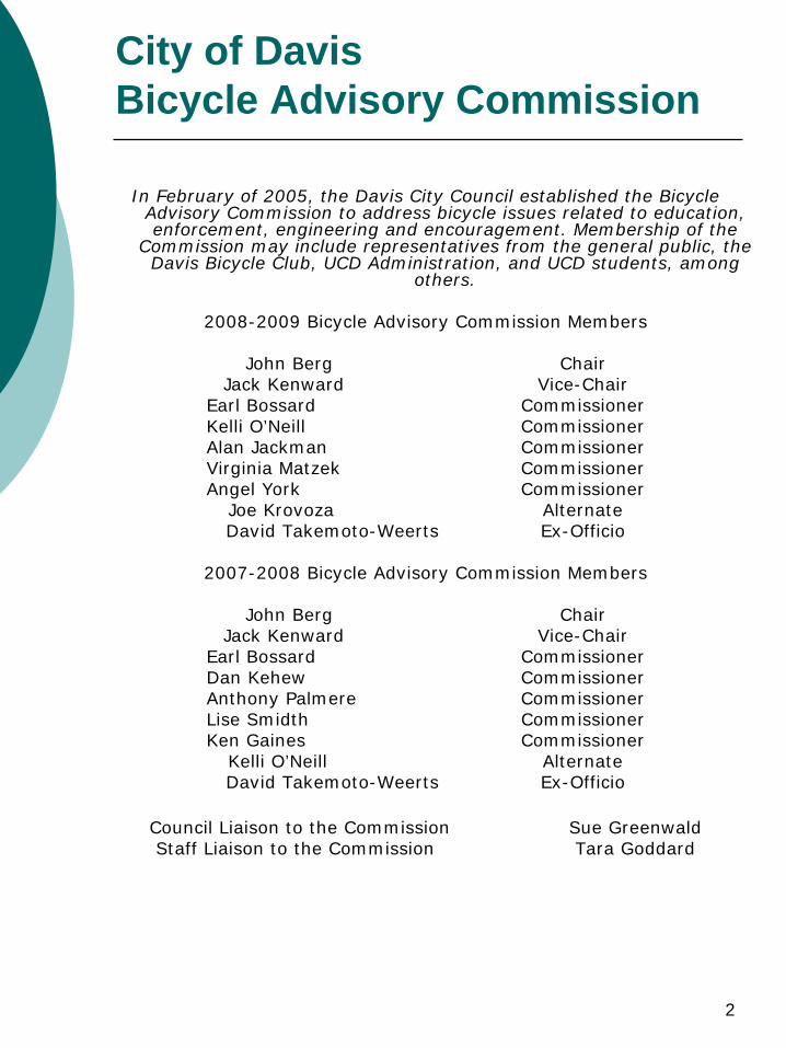
City of Davis Bicycle Advisory Commission
In February of 2005, the Davis City Council established the Bicycle Advisory Commission to address bicycle issues related to education, enforcement, engineering and encouragement. Membership of the
Commission may include representatives from the general public, the Davis Bicycle Club, UCD Administration, and UCD students, among
others.
2008-2009 Bicycle Advisory Commission Members
John Berg ChairJack Kenward Vice-Chair
Earl Bossard CommissionerKelli O’Neill CommissionerAlan Jackman CommissionerVirginia Matzek CommissionerAngel York Commissioner
Joe Krovoza AlternateDavid Takemoto-Weerts Ex-Officio
2007-2008 Bicycle Advisory Commission Members
John Berg ChairJack Kenward Vice-Chair
Earl Bossard CommissionerDan Kehew CommissionerAnthony Palmere CommissionerLise Smidth CommissionerKen Gaines Commissioner
Kelli O’Neill AlternateDavid Takemoto-Weerts Ex-Officio
Council Liaison to the Commission Sue GreenwaldStaff Liaison to the Commission Tara Goddard
3
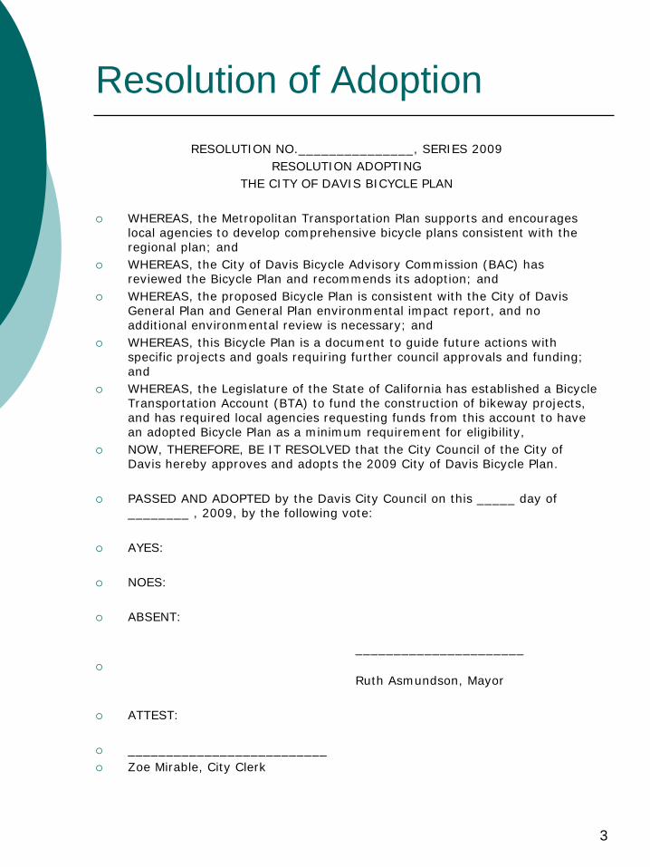
Resolution of Adoption
RESOLUTION NO._______________, SERIES 2009RESOLUTION ADOPTING
THE CITY OF DAVIS BICYCLE PLAN
WHEREAS, the Metropolitan Transportation Plan supports and encourages local agencies to develop comprehensive bicycle plans consistent with the regional plan; and
WHEREAS, the City of Davis Bicycle Advisory Commission (BAC) has reviewed the Bicycle Plan and recommends its adoption; and
WHEREAS, the proposed Bicycle Plan is consistent with the City of Davis General Plan and General Plan environmental impact report, and no additional environmental review is necessary; and
WHEREAS, this Bicycle Plan is a document to guide future actions with specific projects and goals requiring further council approvals and funding; and
WHEREAS, the Legislature of the State of California has established a Bicycle Transportation Account (BTA) to fund the construction of bikeway projects, and has required local agencies requesting funds from this account to have an adopted Bicycle Plan as a minimum requirement for eligibility,
NOW, THEREFORE, BE IT RESOLVED that the City Council of the City of Davis hereby approves and adopts the 2009 City of Davis Bicycle Plan.
PASSED AND ADOPTED by the Davis City Council on this _____ day of ________ , 2009, by the following vote:
AYES:
NOES:
ABSENT:
______________________
Ruth Asmundson, Mayor
ATTEST:
__________________________
Zoe Mirable, City Clerk

RESOLUTION NO. 09-168, SERIES 2009
RESOLUTION ADOPTING THE CITY OF DAVIS BICYCLE PLAN
WHEREAS, the Metropolitan Transportation Plan supports and encourages local agencies to develop comprehensive bicycle plans consistent with the regional plan; and
WHEREAS, the City of Davis Bicycle Advisory Commission (BAC) has reviewed the Bicycle Plan and recommends its adoption; and
WHEREAS, the proposed Bicycle Plan is consistent with the City of Davis General Plan and General Plan environmental impact report, and no additional environmental review is necessary; and
WHEREAS, this Bicycle Plan is a document to guide future actions with specific projects and goals requiring further council approvals and funding; and
WHEREAS, the Legislature of the State of California has established a Bicycle Transportation Account (BTA) to fund the construction of bikeway projects, and has required local agencies requesting funds from this account to have an adopted Bicycle Plan as a minimum requirement for eligibility.
NOW, THEREFORE, BE IT RESOLVED by the City Council of the City of Davis hereby approves and adopts the 2009 City of Davis Bicycle Plan.
PASSED AND ADOPTED by the City Council of the City of Davis this 13' day of October, 2009 by the following vote:
AYES: Greenwald, Heystek, Saylor, Souza
NOES: None
ABSENT: Asmundson
ATTEST:
Don Saylor 4 Mayor Pro Tempore
m. Mirabile, CMC City Clerk
4
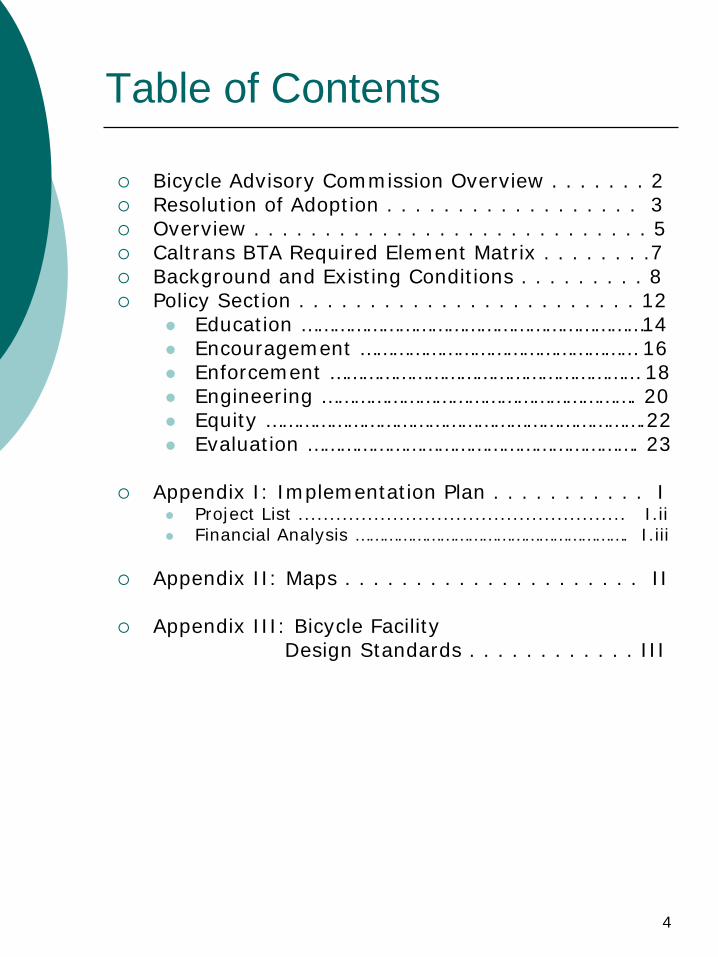
Table of Contents
Bicycle Advisory Commission Overview . . . . . . . 2
Resolution of Adoption . . . . . . . . . . . . . . . . . . 3
Overview . . . . . . . . . . . . . . . . . . . . . . . . . . . . 5
Caltrans BTA Required Element Matrix . . . . . . . .7
Background and Existing Conditions . . . . . . . . . 8
Policy Section . . . . . . . . . . . . . . . . . . . . . . . . 12
Education ………………………………………………………14
Encouragement …………………………………………… 16
Enforcement ………………………………………………… 18
Engineering …………………………………………………. 20
Equity …………………………………………………………….22
Evaluation ……………………………………………………. 23
Appendix I: Implementation Plan . . . . . . . . . . . I
Project List .................................................... I.ii
Financial Analysis …………………………………………………. I.iii
Appendix II: Maps . . . . . . . . . . . . . . . . . . . . . II
Appendix III: Bicycle Facility Design Standards . . . . . . . . . . . . III
5
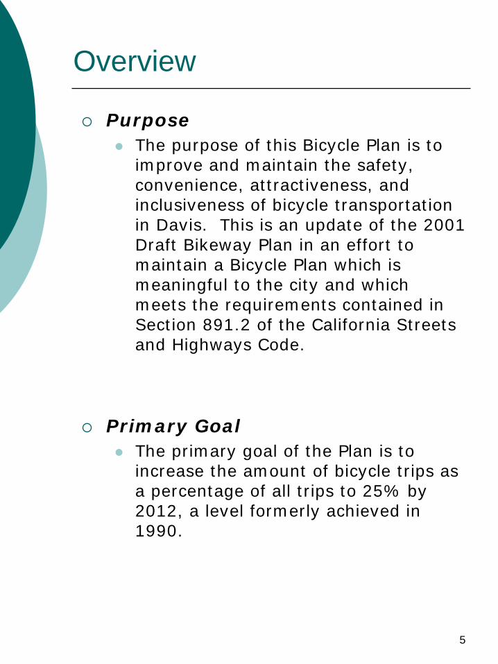
Overview
Purpose
The purpose of this Bicycle Plan is to improve and maintain the safety, convenience, attractiveness, and inclusiveness of bicycle transportation in Davis. This is an update of the 2001 Draft Bikeway Plan in an effort to maintain a Bicycle Plan which is meaningful to the city and which meets the requirements contained in Section 891.2 of the California Streets and Highways Code.
Primary Goal
The primary goal of the Plan is to increase the amount of bicycle trips as a percentage of all trips to 25% by 2012, a level formerly achieved in 1990.
6
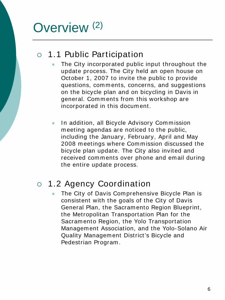
Overview (2)
1.1 Public Participation
The City incorporated public input throughout the update process. The City held an open house on October 1, 2007 to invite the public to provide questions, comments, concerns, and suggestions on the bicycle plan and on bicycling in Davis in general. Comments from this workshop are incorporated in this document.
In addition, all Bicycle Advisory Commission meeting agendas are noticed to the public, including the January, February, April and May 2008 meetings where Commission discussed the bicycle plan update. The City also invited and received comments over phone and email during the entire update process.
1.2 Agency Coordination
The City of Davis Comprehensive Bicycle Plan is consistent with the goals of the City of Davis General Plan, the Sacramento Region Blueprint, the Metropolitan Transportation Plan for the Sacramento Region, the Yolo Transportation Management Association, and the Yolo-Solano Air Quality Management District’s Bicycle and Pedestrian Program.
7
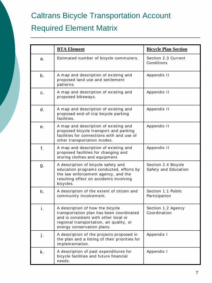
Caltrans Bicycle Transportation Account
Required Element Matrix
BTA Element Bicycle Plan Section
a. Estimated number of bicycle commuters. Section 2.3 Current Conditions
b. A map and description of existing and proposed land use and settlement patterns.
Appendix II
c. A map and description of existing and proposed bikeways.
Appendix II
d. A map and description of existing and proposed end-of-trip bicycle parking facilities.
Appendix II
e. A map and description of existing and proposed bicycle transport and parking facilities for connections with and use of other transportation modes.
Appendix II
f. A map and description of existing and proposed facilities for changing and storing clothes and equipment.
Appendix II
g. A description of bicycle safety and education programs conducted, efforts by the law enforcement agency, and the resulting effect on accidents involving bicycles.
Section 2.4 Bicycle Safety and Education
h. A description of the extent of citizen and community involvement.
Section 1.1 Public Participation
i. A description of how the bicycle transportation plan has been coordinated and is consistent with other local or regional transportation, air quality, or energy conservation plans.
Section 1.2 Agency Coordination
j. A description of the projects proposed in the plan and a listing of their priorities for implementation.
Appendix I
k. A description of past expenditures for bicycle facilities and future financial needs.
Appendix I
8
2. Background and Existing Conditions
2.1 Setting
The City of Davis is located in the southern part of Yolo County, a predominantly agricultural county in California's central valley. Davis is the largest urbanized area within Yolo County.
In 1906, the University of California, Berkeley established the State Agricultural Experiment Station at Davis. The college became a general campus of the University of California System in 1959. Between 1950 and 1987, the average annual growth rate was 6.4 percent per year as the urban population grew from under 5,000 to 48,700. The 2005 in-city population of Davis was approximately 64,000. Approximately 10,000 of the 30,000 UCD students reside within the city limits and are included in the population figure.
Yolo County temperatures are generally mild in the winter and hot in the summer. October through April is the rainy season, and accounts for approximately 90% of the area's annual precipitation.
South Davis is separated from the rest of the City by Interstate Highway 80, which is the major freeway serving the area. West Davis is separated from the rest of the City by State Route 113, which connects I-80 in Davis with the City of Woodland and Interstate Highway 5 to the north. Bicycle- and pedestrian-only overcrossings exist over both I-80 and SR-113 to increase accessibility.
Davis is known for bicycles, energy conservation, and a preference for slow, carefully managed growth. Its notable physical characteristics are small scale in relation to UCD, innovative neighborhood design, a traditional downtown, and an absence of large scale shopping centers. While UC Davis and the City are separate entities, their bicycle networks are intended to be complementary and cohesive.
9
2. Background and Existing Conditions (2)
2.2 History
The University has always had a significant impact on the City of Davis. Historically, the population and geographic spread of the City has been driven by University enrollment. The ratio of City population to UCD enrollment has been steady at about 2:1 over the last twenty years. There is, however, a dramatic shift in demographics now occurring within the City. As the Interstate 80 corridor continues to grow between San Francisco and Sacramento, Davis has a higher percentage of long-distance commuters than it has previously.
Significant use of bicycles in the vicinity of colleges and universities is not uncommon. Bicycles serve the transportation needs of students, faculty, and staff perhaps better than any other mode. As the university grew from about 2,200 students in 1958 to its current enrollment of approximately 30,000, the demands for adequate bicycle facilities and minimization of bicycle- motor vehicle conflicts continued to increase. By the mid- 1960's it became apparent that the existing street network, designed and delineated only for motor vehicles, was inadequate to provide for both bicycle and motor vehicle volumes in the vicinity of the University. A plan to adequately provide for cyclists was needed.
The transportation system pressures described above were finally resolved within the system and processes of municipal government. The primary issue of the April, 1966 City Council election was the provision of bikeways for commuters on the public streets. The pro-bikeway candidates were elected. A trial system of bicycle lanes was quickly installed and proved immensely popular. Rapid expansion of the system followed. Provisions for bicycle facilities were incorporated in design standards for new development. The City bikeway system has steadily and consistently expanded and matured to its present state. The City of Davis has attained national preeminence in bikeway planning and design through its experience and lessons learned during the evolution of the system.
10
2. Background and Existing Conditions (3)
2.3 Current Conditions
Nearly four decades after the City began to actively promote bicycling for transportation Davis was recognized as "America's Best Cycling City" by the Bicycle Federation of America in 1995. The League of American Bicyclists designated the City of Davis as a “Bicycle Friendly Community” in May, 2000 and in October, 2005 the League awarded the City of Davis “Bicycle Friendly Community” status at the Platinum level – the highest level ever awarded to a city in the U.S. With an area just under ten square miles, Davis has approximately 50 miles of on-street bicycle lanes and 52 miles of off-street bicycle paths, some of which run through the City’s extensive greenbelt system. More than 90% of all the collectors and arterial streets within the City have bicycle lanes. As of June 2008, the City has 19 grade-separated crossings.
As a result of aggressively planning for bicycle transportation, ridership within the City is quite high. Estimates from the last census (2002) indicate that approximately 17 percent of all journey-to-work trips are made by bicycle. For most cities, 2% - 3% is considered significant. Although it is recognized that the population of the City has increased, and that the demographics have changed as well, there continues to be a dedicated population of cyclists that utilize bicycles for their primary commute mode. For example, at UC Davis, where the majority of students live off campus, approximately 15,000 students ride a bicycle or walk as their primary mode of getting to class (48%). This is in addition to the 1,800 faculty and staff members that also walk or ride their bicycles to campus (20%). Many of the university based bicycle commuters live in Davis, but others pedal from as far away as Sacramento or Woodland. Traffic data suggest that the bicycle is the dominant transportation mode for
trips crossing the City-University boundary.
11
2. Background and Existing Conditions (4)
The bicycle mode share is also quite high among the rest of Davis residents. There are no public school busses provided by the Davis Joint Unified School District. Some school-aged children walk or ride their bicycles to school. Many of the younger children whose parents commute to work on bicycles will transport them in bicycle trailers, and drop them off on their way to work. Out of a population of 64,000 residents, it is estimated there are over 60,000 bicycles in the City of Davis.
Although a 17% mode share for bicycles is considered substantial, the share has decreased from where it was 10 – 15 years ago. The 1990 census indicated that the percentage of all journey-to-work trips being made by bicycles was hovering around 20 – 25%. By implementing this Plan, the City goal is to increase the percentage of trips made by bicycle to 25%.
2.4 Bicycle Safety and Education
The City of Davis Police Department is integral to the success and safety of bicycling in Davis. In 2007, the Police Department reinstated the Bicycle Officer program, with a part-time officer on bicycle focusing on the downtown and near-campus areas. The officer addresses a variety of bicycle infractions, most commonly stop-sign running, red-light running, and lack of bicycle lights at night. In an effort to promote education of cyclists, the officer gives warning tickets, where appropriate, to educate bicyclists on traffic laws and etiquette, without penalizing new or inexperienced riders. Where warranted, the officer does ticket violators. Tickets for missing bicycle lights can be used for a 10% discount on a light at a local bicycle shop.
12
3.1 Policy Overview
Goals and Objectives
It is the goal of the City of Davis to maintain the current integrated system of bicycle facilities and create future linkages and improvements in the system. This system facilitates safe, convenient travel for bicyclists throughout the City. The City recognizes the need to encourage bicycle travel for both transportation and recreation. Bicycle use conserves energy, contributes to cleaner air, reduces motorized vehicle traffic, reduces the need for automobile parking, and improves personal fitness.
The city’s General Plan Update, completed in 2001, refers to bicycles in various elements contained in the plan. Chapter IV- 2, the Mobility element, contains many of the goals and policies relating to bicycle and pedestrian circulation.
General Plan Update Bicycle-related Policies
Guiding Policies
Assure safe and convenient bicycle access to all areas of the city.
Promote use of bicycles as a viable and attractive alternative to cars.
Implementing Policies
Provide bicycle lanes along all collector and arterial streets.
Consider bicycle-operating characteristics in the design of intersections and traffic control systems.
Develop and implement bicycle parking standards.
Expand and maintain an education program to promote bicycle use and safety.
Require compliance with bikeway policies and standards for new development including bikeways within greenbelts. Ensure interconnection of new facilities with the existing bikeway system.
13
3.1 Policy Overview (2)
Bicycle Plan Goals and Objectives
The Bicycle Advisory Commission, the City, members of local agencies, advocacy groups, and the community developed the following Goals and Objectives to provide greater detail than the General Plan Goals and Policies they support. These Goals and Objectives provide specific guidance to the city for further development of bicycle programs. The Bicycle Plan’s guiding policy is to promote bicycle use as a viable, attractive, healthy, non- polluting form of transportation and to assure safe and convenient access to all areas of the city. The Plan uses six “E’s:” Equity, Education, Encouragement, Engineering, Enforcement and Evaluation, all of which contribute to enhanced bicycle use.
14
3.2 Education
Goal: Increase the safety and attractiveness of bicycling by providing educational programs, tools, and resources.
Objective: Enhance educational programs to teach children and adults safe bicycling techniques.
Objective: Increase and enhance automobile driver education about bicycle laws, behavior, and rights.
Objective: Provide literature and current bicycle route maps for public use.
15
3.2 Education (2)
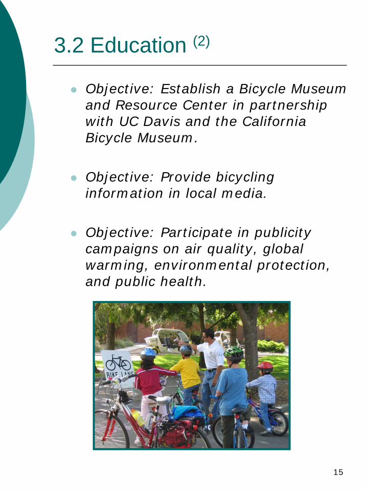
Objective: Establish a Bicycle Museum and Resource Center in partnership with UC Davis and the California Bicycle Museum.
Objective: Provide bicycling information in local media.
Objective: Participate in publicity campaigns on air quality, global warming, environmental protection, and public health.
16
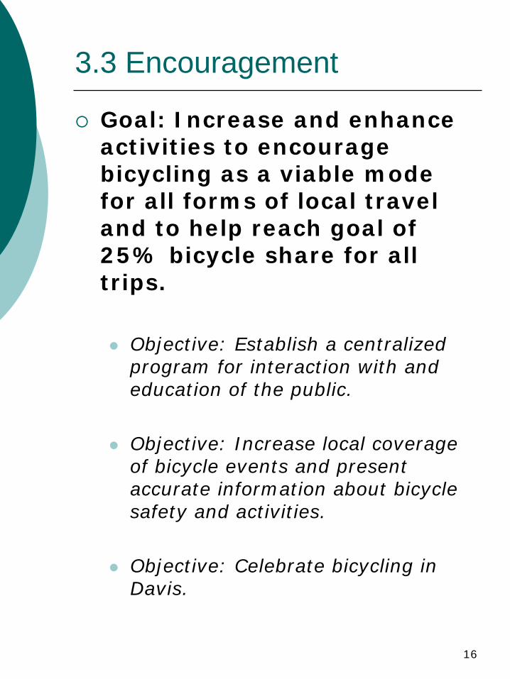
3.3 Encouragement
Goal: Increase and enhance activities to encourage bicycling as a viable mode for all forms of local travel and to help reach goal of 25% bicycle share for all trips.
Objective: Establish a centralized program for interaction with and education of the public.
Objective: Increase local coverage of bicycle events and present accurate information about bicycle safety and activities.
Objective: Celebrate bicycling in Davis.
17
3.3 Encouragement (2)
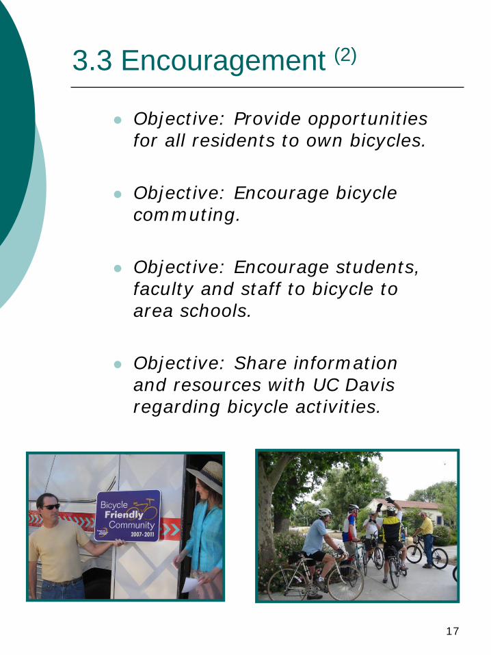
Objective: Provide opportunities for all residents to own bicycles.
Objective: Encourage bicycle commuting.
Objective: Encourage students, faculty and staff to bicycle to area schools.
Objective: Share information and resources with UC Davis regarding bicycle activities.
18
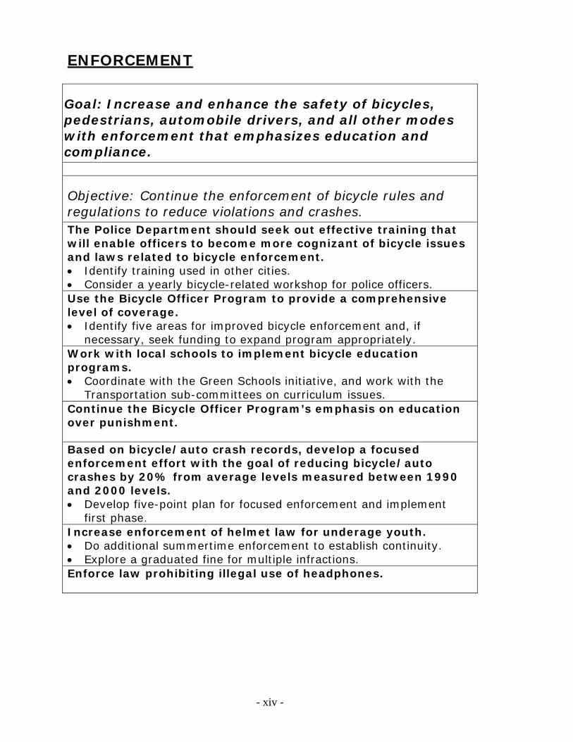
3.4 Enforcement
Goal: Increase and enhance the safety of bicycles, pedestrians, automobile drivers, and all other modes with enforcement that emphasizes education and compliance.
Objective: Continue the enforcement of bicycle rules and regulations to reduce violations and crashes.
Objective: Reduce bicycle theft and increase recovery of stolen bicycles.
19
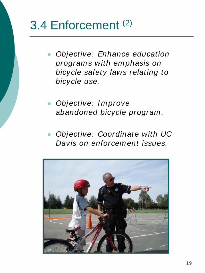
3.4 Enforcement (2)
Objective: Enhance education programs with emphasis on bicycle safety laws relating to bicycle use.
Objective: Improve abandoned bicycle program.
Objective: Coordinate with UC Davis on enforcement issues.
20
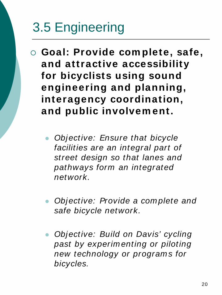
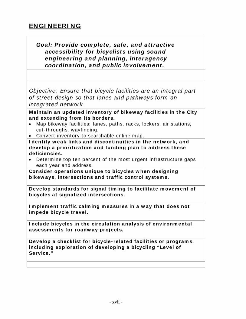
3.5 Engineering
Goal: Provide complete, safe, and attractive accessibility for bicyclists using sound engineering and planning, interagency coordination, and public involvement.
Objective: Ensure that bicycle facilities are an integral part of street design so that lanes and pathways form an integrated network.
Objective: Provide a complete and safe bicycle network.
Objective: Build on Davis’ cycling past by experimenting or piloting new technology or programs for bicycles.
21
3.5 Engineering (2)
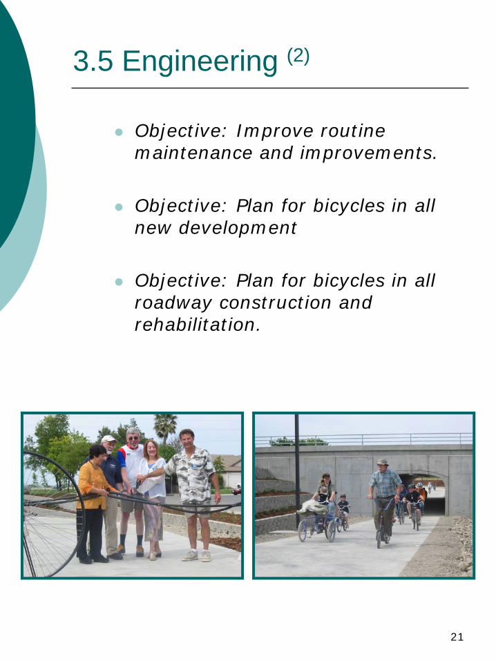
Objective: Improve routine maintenance and improvements.
Objective: Plan for bicycles in all new development
Objective: Plan for bicycles in all roadway construction and rehabilitation.
22
3.6 Equity
Goal: Ensure the viability of bicycles as a transportation mode with equal treatment.
Objective: Consider bicycles in all transportation projects and treat as an equal roadway user in planning, engineering, policy or funding.
Objective: Ensure that bicycling as a viable transportation mode is available to all sectors of the community, and that bicycling is integrated into the local and regional transit network.
23
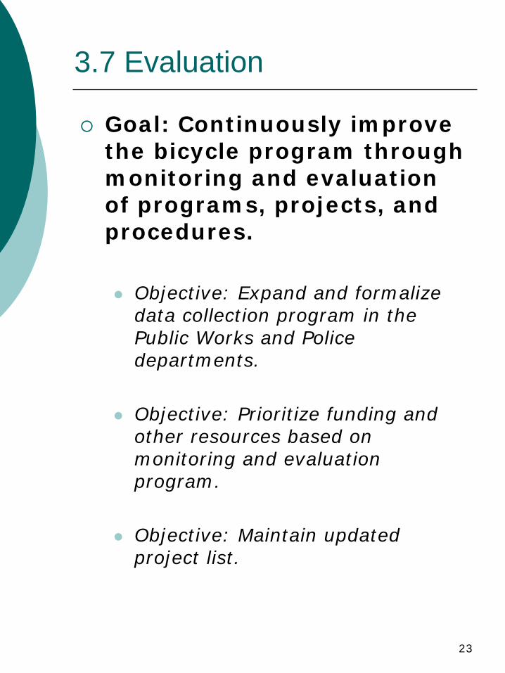
3.7 Evaluation
Goal: Continuously improve the bicycle program through monitoring and evaluation of programs, projects, and procedures.
Objective: Expand and formalize data collection program in the Public Works and Police departments.
Objective: Prioritize funding and other resources based on monitoring and evaluation program.
Objective: Maintain updated project list.
I
Appendix I. Implementation Plan
page intentionally left blank
- i -
City of Davis Bicycle Plan Appendix I: Implementation
The City of Davis Bicycle Plan Implementation (“Implementation Plan”)
contains the specific programs, projects, activities and actions needed to implement the Bicycle Plan (“Bike Plan”). This document is dynamic, and staff will review it each year, with input from the Bicycle Advisory Commission (“Commission”) and the community.
The Implementation Plan reflects the work of staff, input from the
community including advocacy groups, direction from the Commission, and review by University of California, Davis staff. The Implementation Plan is divided into the same sections as the Bike Plan policy: Education, Encouragement, Enforcement, Engineering, Equity and Evaluation. The goals, and their sub-goals, from the Bike Plan are replicated here, followed by the programs, projects, activities or actions required to implement the goals.
Items like cost, deadline and priority are moving targets, and thus will
not be adopted into the Plan. They will be decided by City Council, with input from staff, the Commission and the community.
Each year, along with the review and update of the Implementation
Plan, staff will generate an Annual Report. The Annual Report is also organized like the Bike Plan and the Implementation Plan, and will reflect progress on each item.
_________________ Tara Goddard Bicycle and Pedestrian Coordinator City of Davis
1. ____________ Adoption Date 2. ____________ Update 3. ____________ Update
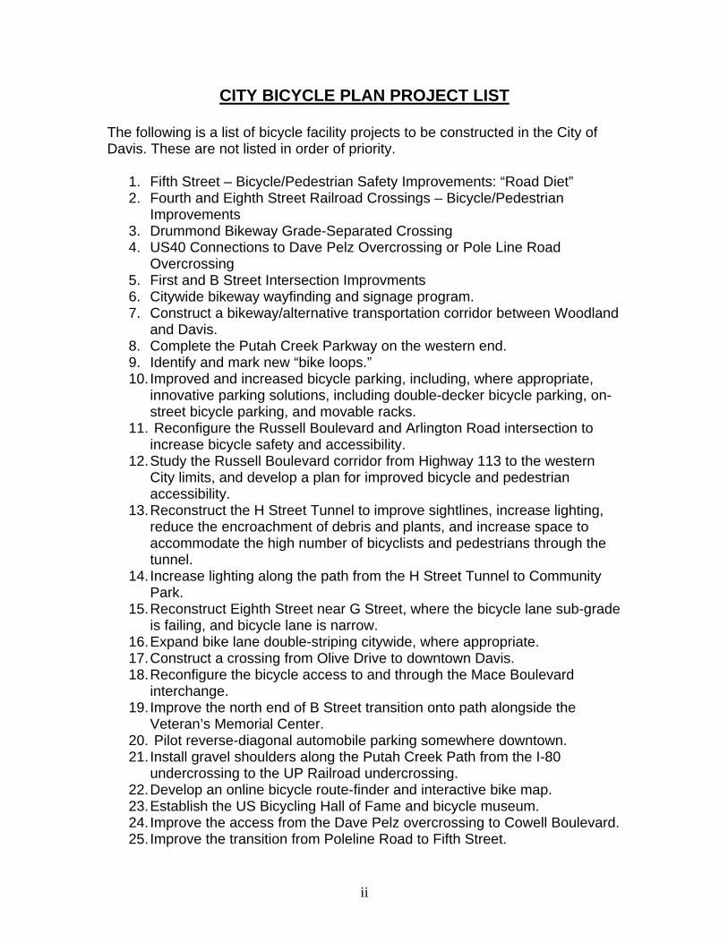
CITY BICYCLE PLAN PROJECT LIST
The following is a list of bicycle facility projects to be constructed in the City of Davis. These are not listed in order of priority.
1. Fifth Street – Bicycle/Pedestrian Safety Improvements: “Road Diet” 2. Fourth and Eighth Street Railroad Crossings – Bicycle/Pedestrian
Improvements 3. Drummond Bikeway Grade-Separated Crossing 4. US40 Connections to Dave Pelz Overcrossing or Pole Line Road
Overcrossing 5. First and B Street Intersection Improvments 6. Citywide bikeway wayfinding and signage program. 7. Construct a bikeway/alternative transportation corridor between Woodland
and Davis. 8. Complete the Putah Creek Parkway on the western end. 9. Identify and mark new “bike loops.” 10. Improved and increased bicycle parking, including, where appropriate,
innovative parking solutions, including double-decker bicycle parking, on-street bicycle parking, and movable racks.
11. Reconfigure the Russell Boulevard and Arlington Road intersection to increase bicycle safety and accessibility.
12. Study the Russell Boulevard corridor from Highway 113 to the western City limits, and develop a plan for improved bicycle and pedestrian accessibility.
13. Reconstruct the H Street Tunnel to improve sightlines, increase lighting, reduce the encroachment of debris and plants, and increase space to accommodate the high number of bicyclists and pedestrians through the tunnel.
14. Increase lighting along the path from the H Street Tunnel to Community Park.
15. Reconstruct Eighth Street near G Street, where the bicycle lane sub-grade is failing, and bicycle lane is narrow.
16. Expand bike lane double-striping citywide, where appropriate. 17. Construct a crossing from Olive Drive to downtown Davis. 18. Reconfigure the bicycle access to and through the Mace Boulevard
interchange. 19. Improve the north end of B Street transition onto path alongside the
Veteran’s Memorial Center. 20. Pilot reverse-diagonal automobile parking somewhere downtown. 21. Install gravel shoulders along the Putah Creek Path from the I-80
undercrossing to the UP Railroad undercrossing. 22. Develop an online bicycle route-finder and interactive bike map. 23. Establish the US Bicycling Hall of Fame and bicycle museum. 24. Improve the access from the Dave Pelz overcrossing to Cowell Boulevard. 25. Improve the transition from Poleline Road to Fifth Street.
ii
ii
26. Covell Boulevard/Mace Boulevard Path rehabilitation. 27. Improve street lighting on Oak Street. 28. Establish a “Bike Station.” 29. Parking Improvements at Little League Field. 30. Re-configure the Eighth Street/J Street/Pennsylvania Lane intersection. 31. H Street Pavement rehabilitation (Class III Corridor). 32. Olive Drive Pavement rehabilitation (Class II Corridor). 33. Complete a Covell Boulevard/SR-113 Interchange Improvement Study. 34. B Street Corridor Improvements - First to Fifth Streets. 35. Construct a grade-separated crossing at F Street near Anderson Road. 36. Construct a grade-separated crossing of the California Northern Tracks
near Anderson Road. 37. Richards Boulevard Corridor Improvements (CIP Project ID A21) 38. Complete path along Mace Boulevard south of Covell Boulevard. 39. Improve Poleline Road from Covell Boulevard to the northern City limits,
adding lighted and landscaped median and bicycle lanes (CIP Project ID A32).
40. Intersection improvements at First/B, Fifth/D, Second/F, First/F and Second/B Streets (CIP Project ID A47-52).
41. Construct a grade-separated overcrossing of SR-113 at the northern City limits (CIP Project ID A59).
42. Construct a grade-separated crossing of Poleline Road at Donner Avenue.
- iii -
BIKE PROGRAM FINANCING Bikeways in Davis may be funded from the full range of financial resources available to the city. These resources include the General Fund, Construction Tax, development impact fees, redevelopment monies, Mello-Roos Bonds, and cost participation by other entities. The appropriate funding is applied to the specific project according to the program or programs to which the project belongs. Additionally, bikeway projects may be eligible for State or Federal funding when a bikeway project meets the appropriate program criteria. These funding sources include the newly enacted “Safe, Accountable, Flexible, Efficient Transportation Equity Act: A Legacy for Users”, or SAFTEA-LU for short, a Federal program that makes funding available for bicycle projects. The State of California has also established dedicated funding for bicycle projects as well. For many years, the California Bicycle Lane Account (BLA) had provided only about $360,000 per year, statewide, for bike projects. As a direct result of lobbying by the California Bicycle Coalition (CBC), this amount was increased to approximately $1,000,000 per year in FY 1999/2000, with a sliding scale that brought it up to $5,000,000 per year by 2004, and annually thereafter. It was actually up to 7.2 million last fiscal year, but despite aggressive lobbying by CBC to keep it at this amount, it appears that it will be going back down to 5 million for the 2006/2007 fiscal year. To be eligible for BTA funds, a local agency must have a current bike plan (as defined in the schedule for each annual application cycle). These plans must address the elements described in Section 891.2 of the Streets and Highways Code. The account is administered by Caltrans and a local match is required. In addition to BTA Funds, another significant funding source for bicycle and pedestrian projects are the “Safe Routes to School” (SR2S and SRTS) programs, which is administered by Caltrans with funding from state and federal sources. VARIABLES IN PROJECT FINANCING AND SCHEDULING Prioritizing bikeway projects in the City of Davis involves a number of variables that include, but are not limited to the following: 1. Bikeway projects are accomplished from a variety of funding sources and combinations of funding sources. Every bikeway project does not compete for funding with all other bikeway projects. 2. Many bikeway projects are undertaken concurrent with a larger project such as a street reconstruction or widening. The priority of the more significant project often determines when a bikeway project will be accomplished.
- iv -
3. Many identified bikeway projects are closely linked to, or a result of development. These projects are often not needed until development actually occurs, and construction of such projects is dependent upon funding provided by the new development. It is difficult to predict accurately the timing for these projects due to the many uncertainties inherent to the development process. 4. Occasionally, the identification, and subsequent accomplishment of a project occurs so quickly (e.g. due to safety concerns, etc), that programming the project is impractical. EXAMPLE PROJECTS The Putah Creek bicycle undercrossing, in the planning stages for almost a decade, was completed in 2003. This latter project had a cost of approximately 7.2 million dollars. Additionally, a bicycle overcrossing of Interstate 80, immediately west of Mace Boulevard, was completed in 2002. This was named the “Dave Pelz Bicycle Overcrossing” after the long-time Davis Public Works Director of the same name. In May 2008, the City opened the undercrossing of Covell Boulevard near Harper Junior High, with a total project cost of approximately 2 million dollars. PROJECT PRIORITIES Aside from the factors referenced above, the following section details the priorities that are considered when making project approval and funding decisions on bike projects: 1. Bicycle facility projects with significant safety concerns are accomplished expeditiously, and placed ahead of system expansion. Projects of this nature are typically submitted to the Safety and Parking Advisory Commission and Bicycle Advisory Commission for review. 2. Projects that will close gaps or improve the operation of the existing bikeway system are given high priority. 3. Projects that expand the bicycle facilities network, including connections to the existing system, are analyzed annually as part of the normal budget process. Projects needed to integrate bicycle facilities provided by development are scheduled and funded during this annual review process. 4. Bikeway projects that enhance the existing system or bring substandard facilities up to standard are balanced according to their importance against other competing projects. The city has an annual program for maintenance and repair of existing bicycle facilities.
- v -
EDUCATION
Goal: Increase the safety and attractiveness of bicycling by providing educational programs, tools, and resources.
Objective: Enhance educational programs to teach children and adults safe bicycling techniques. Enhance existing programs and support local groups that promote safe bicycling techniques and make the information available through schools, work sites and general publicity efforts. Continue to distribute A to Z Guide and Ride Right coloring books at
City events. Support schools on their use of the Amgen Tour of California cycling
guide. Provide support to local PTAs, church groups, cycling advocacy
groups, and any other groups that disseminate bicycle safety information or hold cycling events for their members.
Expand and support a citywide helmet and bicycle light promotion program. Create a program modeled on the City’s Compost Bin program, and
give away bicycle lights to people who take a bicycle safety class. Continue to promote helmet use through bicycle safety poster
contest and bicycle rodeos. Work with Davis Bicycle Club helmet giveaways to provide
additional helmets as needed in town. Develop a plan to increase light use in town, achieving a 50%
reduction in bicycle light warning tickets or citations. Prepare an information flyer about bicycle helmets and lights for all
bicycle shops to hand out with all bicycle purchases, and with all bicycle repairs when owner does not have a helmet or light.
Work with UC Davis, DJUSD and other area schools to implement bicycle education programs. Investigate other safety programs that should be taught to school-aged children, university students, and the public. Investigate development and promotion of “riding tips” clinics aimed at new riders. Hold pilot two new rider clinics during May 2009. Provide information on website for new adult riders.
- vi -
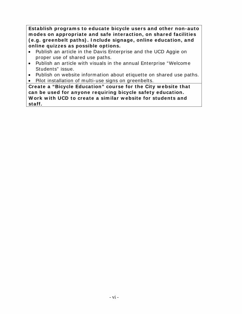
Establish programs to educate bicycle users and other non-auto modes on appropriate and safe interaction, on shared facilities (e.g. greenbelt paths). Include signage, online education, and online quizzes as possible options. Publish an article in the Davis Enterprise and the UCD Aggie on
proper use of shared use paths. Publish an article with visuals in the annual Enterprise “Welcome
Students” issue. Publish on website information about etiquette on shared use paths. Pilot installation of multi-use signs on greenbelts. Create a “Bicycle Education” course for the City website that can be used for anyone requiring bicycle safety education. Work with UCD to create a similar website for students and staff.
- vii -
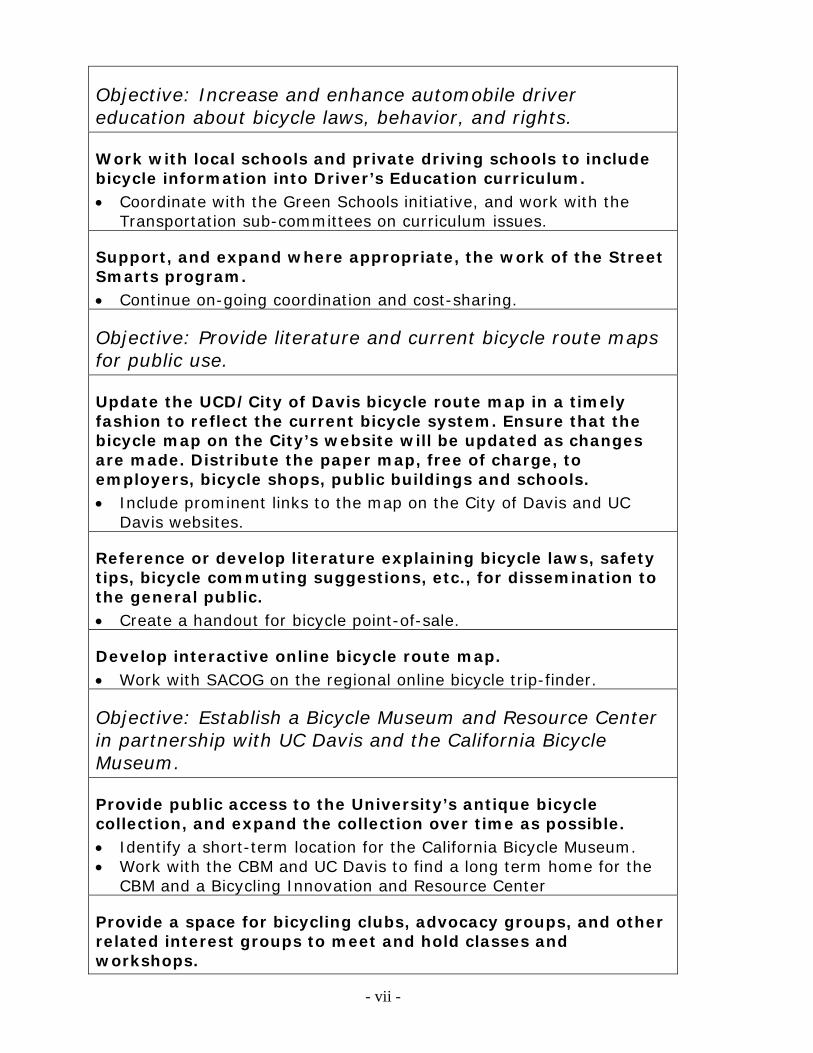
Objective: Increase and enhance automobile driver education about bicycle laws, behavior, and rights.
Work with local schools and private driving schools to include bicycle information into Driver’s Education curriculum. Coordinate with the Green Schools initiative, and work with the
Transportation sub-committees on curriculum issues.
Support, and expand where appropriate, the work of the Street Smarts program. Continue on-going coordination and cost-sharing.
Objective: Provide literature and current bicycle route maps for public use.
Update the UCD/City of Davis bicycle route map in a timely fashion to reflect the current bicycle system. Ensure that the bicycle map on the City’s website will be updated as changes are made. Distribute the paper map, free of charge, to employers, bicycle shops, public buildings and schools. Include prominent links to the map on the City of Davis and UC
Davis websites.
Reference or develop literature explaining bicycle laws, safety tips, bicycle commuting suggestions, etc., for dissemination to the general public. Create a handout for bicycle point-of-sale.
Develop interactive online bicycle route map. Work with SACOG on the regional online bicycle trip-finder.
Objective: Establish a Bicycle Museum and Resource Center in partnership with UC Davis and the California Bicycle Museum.
Provide public access to the University’s antique bicycle collection, and expand the collection over time as possible. Identify a short-term location for the California Bicycle Museum. Work with the CBM and UC Davis to find a long term home for the
CBM and a Bicycling Innovation and Resource Center
Provide a space for bicycling clubs, advocacy groups, and other related interest groups to meet and hold classes and workshops.
- viii -
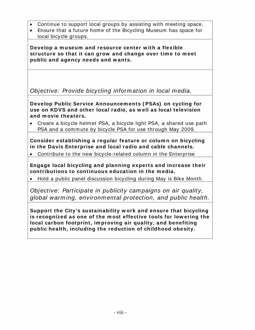
Continue to support local groups by assisting with meeting space. Ensure that a future home of the Bicycling Museum has space for
local bicycle groups.
Develop a museum and resource center with a flexible structure so that it can grow and change over time to meet public and agency needs and wants.
Objective: Provide bicycling information in local media.
Develop Public Service Announcements (PSAs) on cycling for use on KDVS and other local radio, as well as local television and movie theaters. Create a bicycle helmet PSA, a bicycle light PSA, a shared use path
PSA and a commute by bicycle PSA for use through May 2009.
Consider establishing a regular feature or column on bicycling in the Davis Enterprise and local radio and cable channels. Contribute to the new bicycle-related column in the Enterprise
Engage local bicycling and planning experts and increase their contributions to continuous education in the media. Hold a public panel discussion bicycling during May is Bike Month.
Objective: Participate in publicity campaigns on air quality, global warming, environmental protection, and public health.
Support the City’s sustainability work and ensure that bicycling is recognized as one of the most effective tools for lowering the local carbon footprint, improving air quality, and benefiting public health, including the reduction of childhood obesity.
- ix -
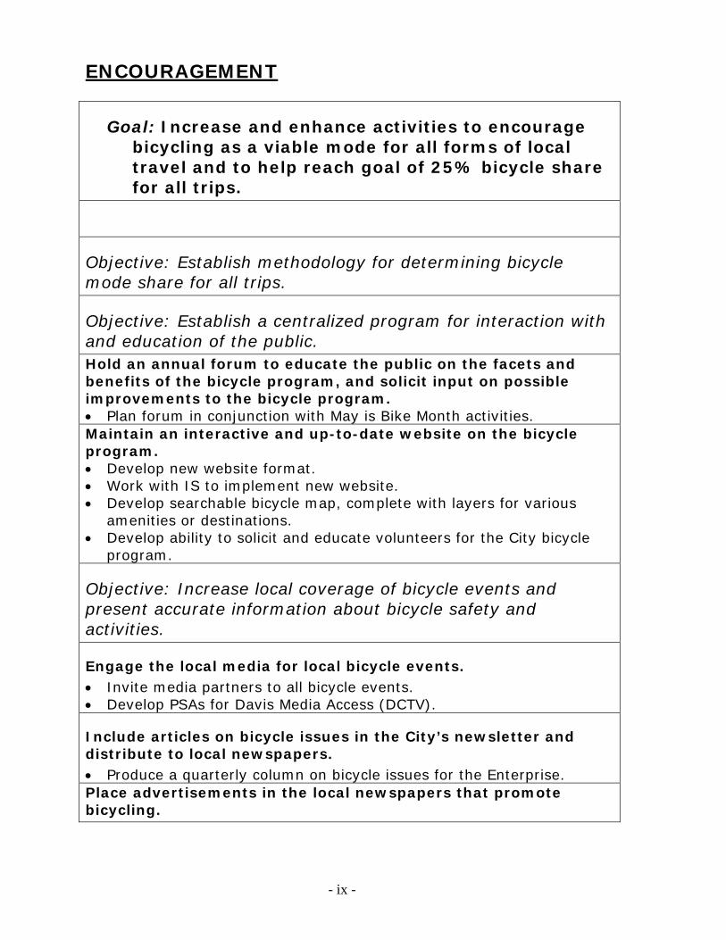
ENCOURAGEMENT
Goal: Increase and enhance activities to encourage bicycling as a viable mode for all forms of local travel and to help reach goal of 25% bicycle share for all trips.
Objective: Establish methodology for determining bicycle mode share for all trips.
Objective: Establish a centralized program for interaction with and education of the public. Hold an annual forum to educate the public on the facets and benefits of the bicycle program, and solicit input on possible improvements to the bicycle program. Plan forum in conjunction with May is Bike Month activities. Maintain an interactive and up-to-date website on the bicycle program. Develop new website format. Work with IS to implement new website. Develop searchable bicycle map, complete with layers for various
amenities or destinations. Develop ability to solicit and educate volunteers for the City bicycle
program.
Objective: Increase local coverage of bicycle events and present accurate information about bicycle safety and activities.
Engage the local media for local bicycle events. Invite media partners to all bicycle events. Develop PSAs for Davis Media Access (DCTV).
Include articles on bicycle issues in the City’s newsletter and distribute to local newspapers. Produce a quarterly column on bicycle issues for the Enterprise. Place advertisements in the local newspapers that promote bicycling.
- x -
Place advertisements on Unitrans busses that promote bicycling. Develop campaign to encourage bus riders to use their bicycles.
Include on-bus PSAs about etiquette, safety, etc.
Objective: Celebrate bicycling in Davis.
Hold ceremonies and “ribbon-cuttings” to celebrate bicycle program and infrastructure accomplishments. Install a few historic signs: "Welcome to Davis, CA: Home of 80,000
Bicycles!" Develop new “Bicycle Loops” and hold inaugural rides. Purchase "2007-2011" stickers to update Platinum signs around town.
Create a Bicycle Advisory Commission award program that recognizes local champions of cycling. Develop award program.
Develop themed loops or rides celebrating facets of Davis life. Possible ride themes include: museums, art galleries, open
spaces/wildlife areas, educational destinations (e.g. Explorit), parks, sustainable facilities (e.g. Village Homes, PVUSA), sports facilities/fields/courses, and more.
Hold a public workshop to gather input from the community on themed rides or permanent loops.
Prepare three new loops and five themed rides. Provide information on each on the City website, and when money is available, paint the permanent loops.
Building upon the foundation of previous Cyclebrations, develop a California Cycling Festival. Support local advocacy groups for spring Cycling Festival. Determine cost/benefit for a California Cycling Festival.
- xi -
Objective: Provide opportunities for all residents to own bicycles.
Reestablish bicycle sale or bicycle auction for local residents. Determine cost/benefit for doing twice-yearly bicycle auction. Determine cost/benefit for facilitating a city "bike swap."
Create bicycles and bicycle parts donation program for charities. Support work of advocacy groups in this effort.
Consider no-interest loan programs for bicycles. Maintain City employee no-interest loan program. Encourage other large employers to implement a similar program.
Objective: Encourage bicycle use for work and non-work trips.
Work with businesses and organizations to encourage employees tcommute by bicycle.
Encourage other large employers to implement a no-interest bike loan program.
Establish standards for employee bicycle parking, and encourage the inclusion of other bicycle commute necessities, such as showers or storage space. Include employee bicycle parking standards and guidelines in a City
Bicycle Parking ordinance.
Work with neighboring jurisdictions, including UC Davis, to facilitate seamless commutes for cross-jurisdictional routes. Complete a Davis-Woodland Bikeway feasibility study. Explore continuing the Russell bicycle path all the way to Winters. Improve Mace and Richard Interchanges to safely accommodate
bicycles.
- xii -
Encourage shopping by bicycle Work with the Farmer's Market to do a monthly "Bike to Market"
event with incentives. Inventory bicycle parking downtown and at all commercial centers,
and develop plan to improve or enhance bicycle parking.
Encourage citizens to travel to City events by bicycle Provide bicycle valet parking at all City events with expected
attendance greater than 1,000 people. Provide, where possible, incentives for residents to arrive at City
events by bicycle. Offer incentives for people who attend City meetings (e.g. Council) by
bicycle.
Objective: Encourage students, faculty and staff to bicycle to area schools.
Improve public perception regarding safety of routes. Collect and publish crime statistics. Collect and publish crash statistics.
Explore “bicycle caravan” programs similar to “walking school bus” programs. Use a school survey to gauge interest in rolling school bus program,
including parents willing to volunteer. Pilot a rolling school bus during May is Bike Month.
Encourage Parent Teacher Associations (PTAs) to form bicycling/walking sub-committees that focus on safety and encouragement. Speak at each PTA meeting and provide support for PTA sub-
committees that form.
Ensure secure and convenient connectivity to all local schools. Update Suggested Routes to Schools maps as needed. Identify network gaps and "problem areas." Develop a 3-year plan for addressing gaps and other issues. Implement wayfinding which includes signage to schools.
Work with schools to provide sufficient and secure bicycle parking for students. Use a school survey and school bicycle rack use counts to determine
parking needs at each school. Offer technical support and data to DJUSD for improving bicycle
parking.
Engage students in bicycle planning.
Focus on encouraging high school students to continue bicycling even after they have reached driving age. Do a school survey to determine high school-specific needs and
issues. Develop yearly incentive program to get high schoolers bicycling
more. Explore restriction and design changes to high school parking lots.
Implement “train the trainer” programs, so high school kids can become bicycling instructors in the community. Set up train-the-trainer program.
Consider working with schools to establish incentives or awards for youth who commute by bicycle to school (similar to attendance awards). Meet with DJUSD to pursue.
Objective: Share information and resources with UC Davis regarding bicycle activities.
Continue liaison with UCD’s Committee on Bicycle Programs. Ensure continuity among City and UCD bicycle planning and
engineering, where appropriate.
Continue/expand annual events with joint City and UCD participation to promote bicycling. Promote bicycling to Picnic Day and Whole Earth Festival by
suggesting routes and leading escorted rides from around town.
Investigate public/private partnerships for joint sponsorship of special bicycling events.
Continue dialogue with the academic community. Explore opportunities for shared research and data collection. Hold a meeting regarding research needs and opportunities.
- xiii -
ENFORCEMENT
Goal: Increase and enhance the safety of bicycles, pedestrians, automobile drivers, and all other modes with enforcement that emphasizes education and compliance.
Objective: Continue the enforcement of bicycle rules and regulations to reduce violations and crashes. The Police Department should seek out effective training that will enable officers to become more cognizant of bicycle issues and laws related to bicycle enforcement. Identify training used in other cities. Consider a yearly bicycle-related workshop for police officers. Use the Bicycle Officer Program to provide a comprehensive level of coverage. Identify five areas for improved bicycle enforcement and, if
necessary, seek funding to expand program appropriately. Work with local schools to implement bicycle education programs. Coordinate with the Green Schools initiative, and work with the
Transportation sub-committees on curriculum issues. Continue the Bicycle Officer Program’s emphasis on education over punishment. Based on bicycle/auto crash records, develop a focused enforcement effort with the goal of reducing bicycle/auto crashes by 20% from average levels measured between 1990 and 2000 levels. Develop five-point plan for focused enforcement and implement
first phase. Increase enforcement of helmet law for underage youth. Do additional summertime enforcement to establish continuity. Explore a graduated fine for multiple infractions. Enforce law prohibiting illegal use of headphones.
- xiv -
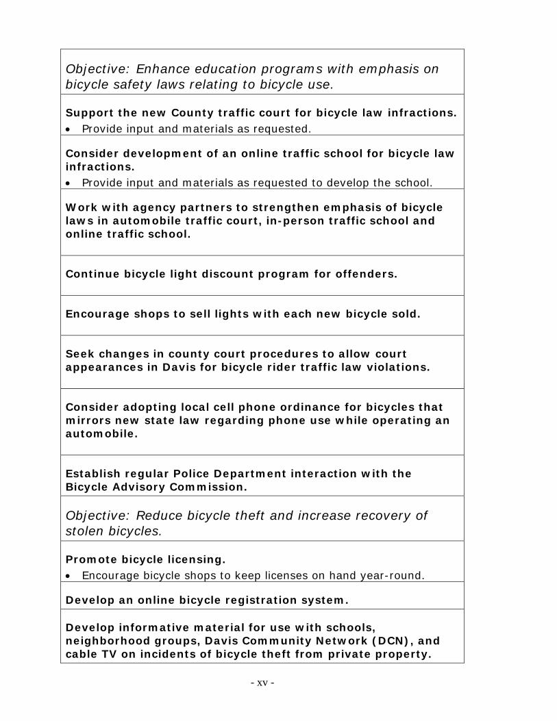
Objective: Enhance education programs with emphasis on bicycle safety laws relating to bicycle use.
Support the new County traffic court for bicycle law infractions. Provide input and materials as requested.
Consider development of an online traffic school for bicycle law infractions. Provide input and materials as requested to develop the school.
Work with agency partners to strengthen emphasis of bicycle laws in automobile traffic court, in-person traffic school and online traffic school.
Continue bicycle light discount program for offenders.
Encourage shops to sell lights with each new bicycle sold.
Seek changes in county court procedures to allow court appearances in Davis for bicycle rider traffic law violations.
Consider adopting local cell phone ordinance for bicycles that mirrors new state law regarding phone use while operating an automobile.
Establish regular Police Department interaction with the Bicycle Advisory Commission.
Objective: Reduce bicycle theft and increase recovery of stolen bicycles.
Promote bicycle licensing. Encourage bicycle shops to keep licenses on hand year-round.
Develop an online bicycle registration system.
Develop informative material for use with schools, neighborhood groups, Davis Community Network (DCN), and cable TV on incidents of bicycle theft from private property.
- xv -
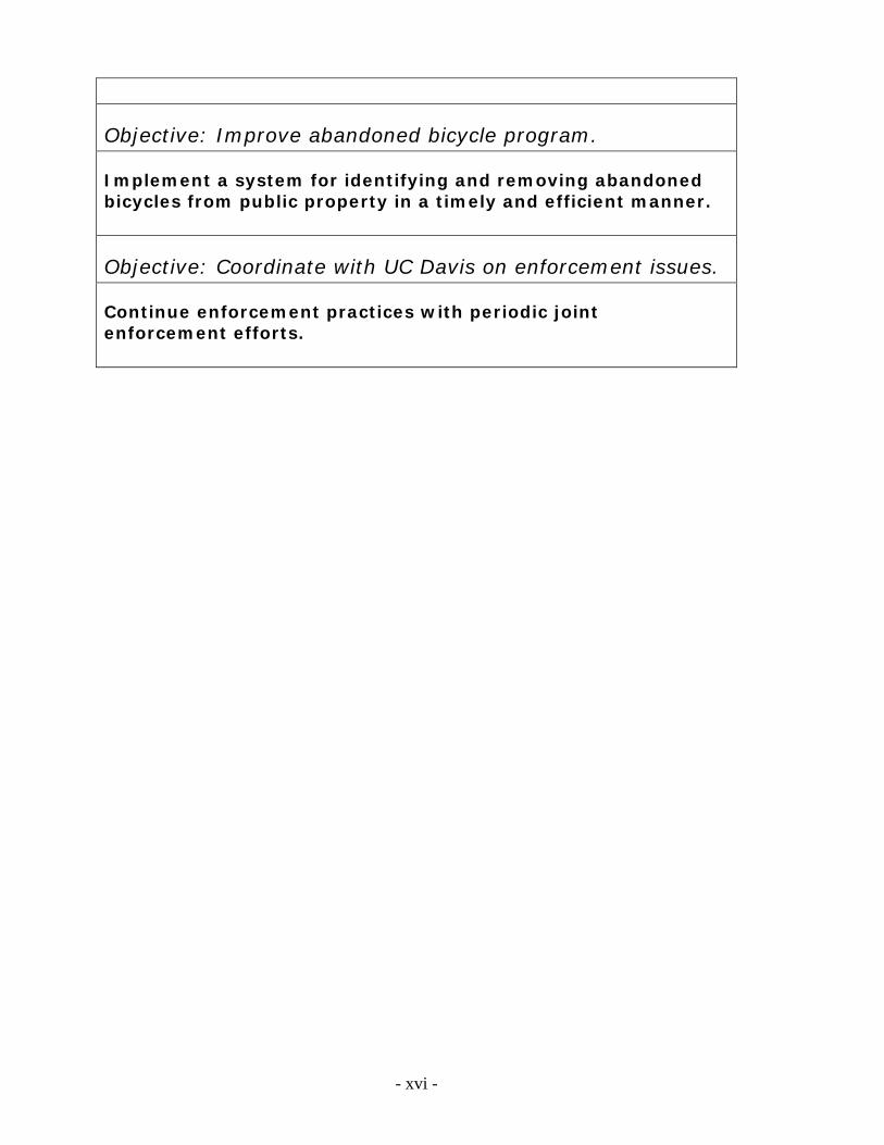
Objective: Improve abandoned bicycle program.
Implement a system for identifying and removing abandoned bicycles from public property in a timely and efficient manner.
Objective: Coordinate with UC Davis on enforcement issues.
Continue enforcement practices with periodic joint enforcement efforts.
- xvi -
ENGINEERING
Goal: Provide complete, safe, and attractive accessibility for bicyclists using sound engineering and planning, interagency coordination, and public involvement.
Objective: Ensure that bicycle facilities are an integral part of street design so that lanes and pathways form an integrated network. Maintain an updated inventory of bikeway facilities in the City and extending from its borders. Map bikeway facilities: lanes, paths, racks, lockers, air stations,
cut-throughs, wayfinding. Convert inventory to searchable online map. Identify weak links and discontinuities in the network, and develop a prioritization and funding plan to address these deficiencies. Determine top ten percent of the most urgent infrastructure gaps
each year and address. Consider operations unique to bicycles when designing bikeways, intersections and traffic control systems. Develop standards for signal timing to facilitate movement of bicycles at signalized intersections. Implement traffic calming measures in a way that does not impede bicycle travel. Include bicycles in the circulation analysis of environmental assessments for roadway projects. Develop a checklist for bicycle-related facilities or programs, including exploration of developing a bicycling “Level of Service.”
- xvii -
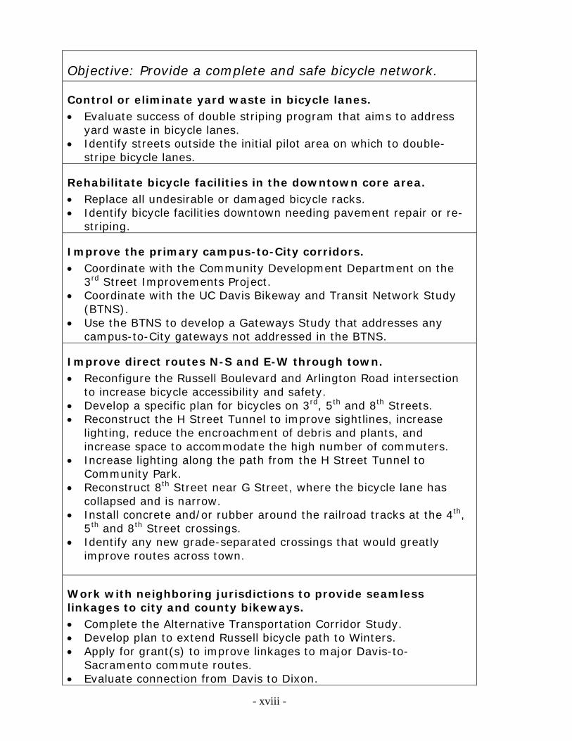
Objective: Provide a complete and safe bicycle network.
Control or eliminate yard waste in bicycle lanes. Evaluate success of double striping program that aims to address
yard waste in bicycle lanes. Identify streets outside the initial pilot area on which to double-
stripe bicycle lanes.
Rehabilitate bicycle facilities in the downtown core area. Replace all undesirable or damaged bicycle racks. Identify bicycle facilities downtown needing pavement repair or re-
striping.
Improve the primary campus-to-City corridors. Coordinate with the Community Development Department on the
3rd Street Improvements Project. Coordinate with the UC Davis Bikeway and Transit Network Study
(BTNS). Use the BTNS to develop a Gateways Study that addresses any
campus-to-City gateways not addressed in the BTNS.
Improve direct routes N-S and E-W through town. Reconfigure the Russell Boulevard and Arlington Road intersection
to increase bicycle accessibility and safety. Develop a specific plan for bicycles on 3rd, 5th and 8th Streets. Reconstruct the H Street Tunnel to improve sightlines, increase
lighting, reduce the encroachment of debris and plants, and increase space to accommodate the high number of commuters.
Increase lighting along the path from the H Street Tunnel to Community Park.
Reconstruct 8th Street near G Street, where the bicycle lane has collapsed and is narrow.
Install concrete and/or rubber around the railroad tracks at the 4th, 5th and 8th Street crossings.
Identify any new grade-separated crossings that would greatly improve routes across town.
Work with neighboring jurisdictions to provide seamless linkages to city and county bikeways. Complete the Alternative Transportation Corridor Study. Develop plan to extend Russell bicycle path to Winters. Apply for grant(s) to improve linkages to major Davis-to-
Sacramento commute routes. Evaluate connection from Davis to Dixon.
- xviii -
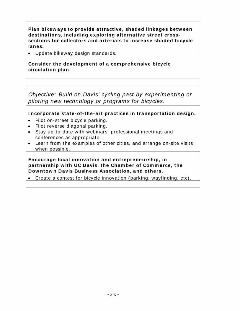
Plan bikeways to provide attractive, shaded linkages between destinations, including exploring alternative street cross-sections for collectors and arterials to increase shaded bicycle lanes. Update bikeway design standards.
Consider the development of a comprehensive bicycle circulation plan.
Objective: Build on Davis’ cycling past by experimenting or piloting new technology or programs for bicycles.
Incorporate state-of-the-art practices in transportation design. Pilot on-street bicycle parking. Pilot reverse diagonal parking. Stay up-to-date with webinars, professional meetings and
conferences as appropriate. Learn from the examples of other cities, and arrange on-site visits
when possible.
Encourage local innovation and entrepreneurship, in partnership with UC Davis, the Chamber of Commerce, the Downtown Davis Business Association, and others. Create a contest for bicycle innovation (parking, wayfinding, etc).
- xix -
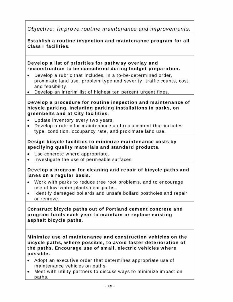
Objective: Improve routine maintenance and improvements.
Establish a routine inspection and maintenance program for all Class I facilities.
Develop a list of priorities for pathway overlay and reconstruction to be considered during budget preparation. Develop a rubric that includes, in a to-be-determined order,
proximate land use, problem type and severity, traffic counts, cost, and feasibility.
Develop an interim list of highest ten percent urgent fixes.
Develop a procedure for routine inspection and maintenance of bicycle parking, including parking installations in parks, on greenbelts and at City facilities. Update inventory every two years. Develop a rubric for maintenance and replacement that includes
type, condition, occupancy rate, and proximate land use.
Design bicycle facilities to minimize maintenance costs by specifying quality materials and standard products. Use concrete where appropriate. Investigate the use of permeable surfaces.
Develop a program for cleaning and repair of bicycle paths and lanes on a regular basis. Work with parks to reduce tree root problems, and to encourage
use of low-water plants near paths. Identify damaged bollards and unsafe bollard postholes and repair
or remove.
Construct bicycle paths out of Portland cement concrete and program funds each year to maintain or replace existing asphalt bicycle paths.
Minimize use of maintenance and construction vehicles on the bicycle paths, where possible, to avoid faster deterioration of the paths. Encourage use of small, electric vehicles where possible. Adopt an executive order that determines appropriate use of
maintenance vehicles on paths. Meet with utility partners to discuss ways to minimize impact on
paths.
- xx -
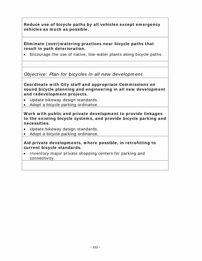
Reduce use of bicycle paths by all vehicles except emergency vehicles as much as possible.
Eliminate (over)watering practices near bicycle paths that result in path deterioration. Encourage the use of native, low-water plants along bicycle paths.
Objective: Plan for bicycles in all new development.
Coordinate with City staff and appropriate Commissions on sound bicycle planning and engineering in all new development and redevelopment projects. Update bikeway design standards. Adopt a bicycle parking ordinance.
Work with public and private development to provide linkages to the existing bicycle systems, and provide bicycle parking and necessities. Update bikeway design standards. Adopt a bicycle parking ordinance.
Aid private developments, where possible, in retrofitting to current bicycle standards. Inventory major private shopping centers for parking and
connectivity.
- xxi -
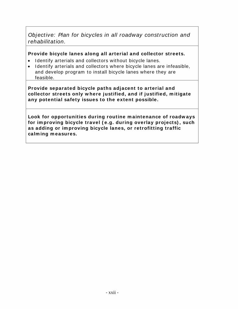
Objective: Plan for bicycles in all roadway construction and rehabilitation.
Provide bicycle lanes along all arterial and collector streets. Identify arterials and collectors without bicycle lanes. Identify arterials and collectors where bicycle lanes are infeasible,
and develop program to install bicycle lanes where they are feasible.
Provide separated bicycle paths adjacent to arterial and collector streets only where justified, and if justified, mitigate any potential safety issues to the extent possible.
Look for opportunities during routine maintenance of roadways for improving bicycle travel (e.g. during overlay projects), such as adding or improving bicycle lanes, or retrofitting traffic calming measures.
- xxii -
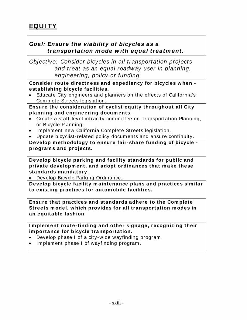
EQUITY
Goal: Ensure the viability of bicycles as a transportation mode with equal treatment.
Objective: Consider bicycles in all transportation projects and treat as an equal roadway user in planning, engineering, policy or funding.
Consider route directness and expediency for bicycles when -establishing bicycle facilities. Educate City engineers and planners on the effects of California's
Complete Streets legislation. Ensure the consideration of cyclist equity throughout all City planning and engineering documents. Create a staff-level intracity committee on Transportation Planning,
or Bicycle Planning. Implement new California Complete Streets legislation. Update bicyclist-related policy documents and ensure continuity. Develop methodology to ensure fair-share funding of bicycle -programs and projects. Develop bicycle parking and facility standards for public and private development, and adopt ordinances that make these standards mandatory. Develop Bicycle Parking Ordinance. Develop bicycle facility maintenance plans and practices similar to existing practices for automobile facilities.
Ensure that practices and standards adhere to the Complete Streets model, which provides for all transportation modes in an equitable fashion Implement route-finding and other signage, recognizing their importance for bicycle transportation. Develop phase I of a city-wide wayfinding program. Implement phase I of wayfinding program.
- xxiii -
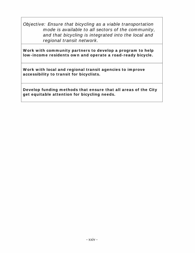
Objective: Ensure that bicycling as a viable transportation mode is available to all sectors of the community, and that bicycling is integrated into the local and regional transit network.
Work with community partners to develop a program to help low-income residents own and operate a road-ready bicycle.
Work with local and regional transit agencies to improve accessibility to transit for bicyclists.
Develop funding methods that ensure that all areas of the City get equitable attention for bicycling needs.
- xxiv -
- xxv -
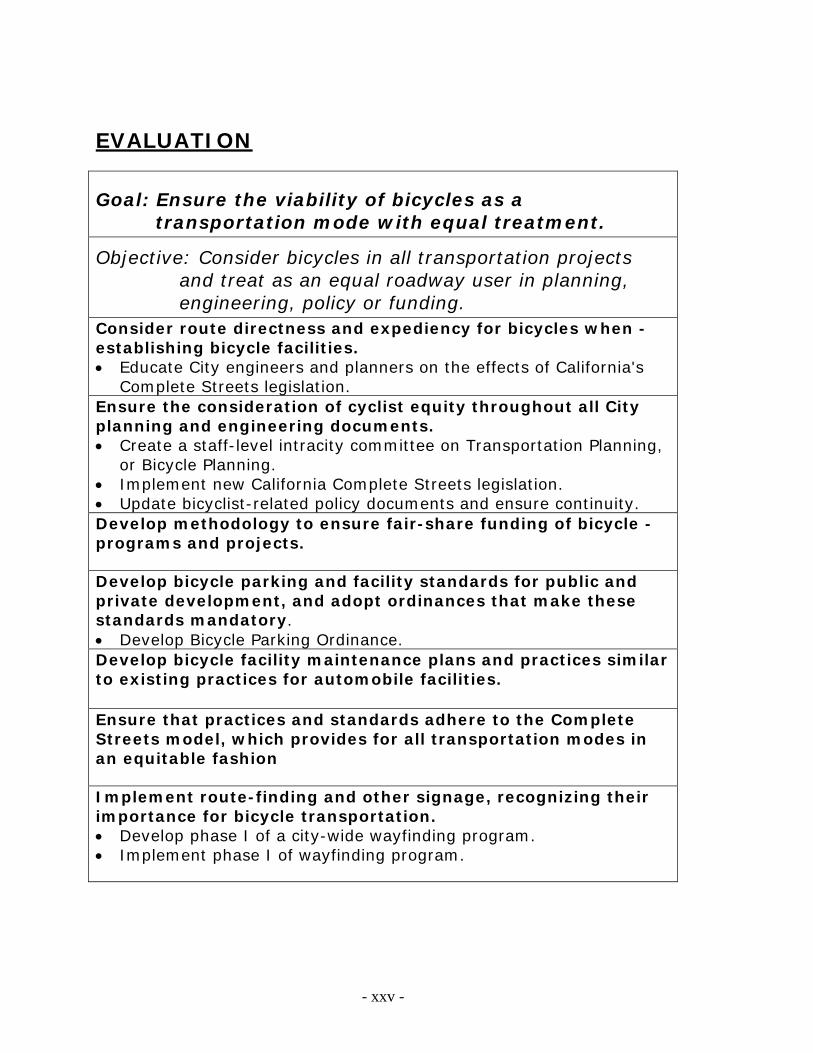
EVALUATION
Goal: Ensure the viability of bicycles as a transportation mode with equal treatment.
Objective: Consider bicycles in all transportation projects and treat as an equal roadway user in planning, engineering, policy or funding.
Consider route directness and expediency for bicycles when -establishing bicycle facilities. Educate City engineers and planners on the effects of California's
Complete Streets legislation. Ensure the consideration of cyclist equity throughout all City planning and engineering documents. Create a staff-level intracity committee on Transportation Planning,
or Bicycle Planning. Implement new California Complete Streets legislation. Update bicyclist-related policy documents and ensure continuity. Develop methodology to ensure fair-share funding of bicycle -programs and projects. Develop bicycle parking and facility standards for public and private development, and adopt ordinances that make these standards mandatory. Develop Bicycle Parking Ordinance. Develop bicycle facility maintenance plans and practices similar to existing practices for automobile facilities.
Ensure that practices and standards adhere to the Complete Streets model, which provides for all transportation modes in an equitable fashion Implement route-finding and other signage, recognizing their importance for bicycle transportation. Develop phase I of a city-wide wayfinding program. Implement phase I of wayfinding program.
II
Appendix II. Maps
page intentionally left blank
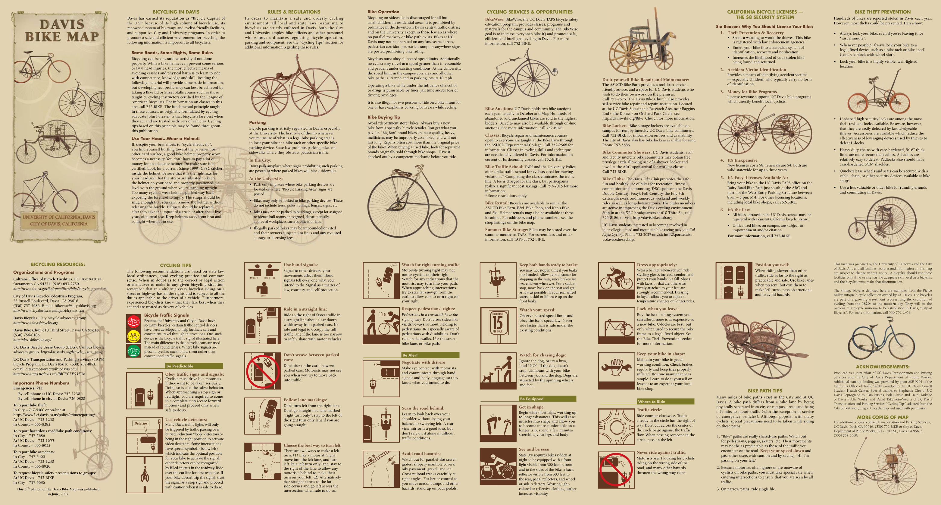
Bicycling ResouRces:
organizations and ProgramsCaltrans Office of Bicycle Facilities, P.O. Box 942874, Sacramento CA 94274, (916) 653-2750. http://www.dot.ca.gov/hq/tpp/offices/bike/bicycle_prgm.htm
City of Davis Bicycle/Pedestrian Program, 23 Russell Boulevard, Davis, CA 95616, (530) 757-5686. E-mail: [email protected] http://www.city.davis.ca.us/topic/bicycles.cfm
Davis Bicycles! City bicycle advocacy group. http://www.davisbicycles.org
Davis Bike Club, 610 Third Street, Davis CA 95616, (530) 756-0186. http://davisbikeclub.org/
UC Davis Bicycle Users Group (BUG), Campus bicycle advocacy group. http://daviswiki.org/bicycle_users_group
UC Davis Transportation and Parking Services (TAPS) Bicycle Program, UC Davis 95616, (530) 752-BIKE. e-mail: [email protected] http://www.taps.ucdavis.edu/BICYCLES.HTM
important Phone numbersEmergencies: 911
By cell phone at UC Davis: 752-1230 By cell phone in city of Davis: 756-0800
To report bike theft: In City – 747-5400 or on-line at https://www2.ci.davis.ca.us/police/crimereporting/ At UC Davis – 752-1230 In County – 666-8282
To report hazardous road/bike path conditions: In City – 757-5686 At UC Davis – 752-1655 In County – 666-8032
To report bike accidents: In City – 747-5400 At UC Davis – 752-1230 In County – 666-8920
To request bicycle safety presentations to groups: At UC Davis – 752-BIKE In City – 757-5686
This 5th edition of the Davis Bike Map was published in June, 2007
Bicycling in DAVisDavis has earned its reputation as “Bicycle Capital of the U.S.” because of its high volume of bicycle use, its renowned system of bikeways and cyclist-friendly facilities, and supportive City and University programs. In order to promote a safe and efficient environment for bicycling, the following information is important to all bicyclists.
same Roads, same Rights, same RulesBicycling can be a hazardous activity if not done properly. While a bike helmet can prevent some serious or fatal head injuries, the most effective means of avoiding crashes and physical harm is to learn to ride with competence, knowledge and skill. Reading the following material will provide some basic information, but developing real proficiency can best be achieved by taking a Bike Ed or Street Skills course such as those taught by cycling instructors certified by the League of American Bicyclists. For information on classes in this area call 752-BIKE. The fundamental principle taught in these courses, as originally formulated by cycling advocate John Forester, is that bicyclists fare best when they act and are treated as drivers of vehicles. Cycling tips based on this principle may be found throughout this publication.
use your Head...Wear a Helmet!If, despite your best efforts to “cycle effectively”, you find yourself hurtling toward the pavement or other hard surface, a good bike helmet properly worn becomes a necessity. You don’t have to pay a lot of money for an adequate helmet. Do make sure it is certified. Look for a current (since 1999) CPSC sticker inside the helmet. Be sure that it is the right size for your head and that the straps are adjusted to keep the helmet on your head and properly positioned, i.e. level with the ground when you’re standing upright. Too many cyclists wear helmets pushed way back exposing the forehead to injury. The straps should be snug enough that you can’t remove the helmet without releasing the buckle. Helmets should be replaced after they take the impact of a crash or after about five years of normal use. Keep helmets away from heat and sunlight when not in use.
Rules & RegulATionsIn order to maintain a safe and orderly cycling environment, all local and state laws pertaining to bicyclists are strictly enforced in Davis. Both the City and University employ bike officers and other personnel who enforce ordinances regulating bicycle operation, parking and equipment. See the “Cycling Tips” section for additional information regarding these rules.
ParkingBicycle parking is strictly regulated in Davis, especially at the University. The best rule of thumb whenever you’re unsure of what is a legal bike parking area is to lock your bike at a bike rack or other specific bike parking device. State law prohibits parking bikes on sidewalks where they obstruct pedestrian traffic.
In the City:Don’t park anyplace where signs prohibiting such parking are posted or where parked bikes will block sidewalks.
At the University:• Park only in places where bike parking devices are
located or where “Bicycle Parking Area” signs are posted.
• Bikes may only be locked to bike parking devices. These do not include trees, poles, railings, fences, signs, etc.
• Bikes may not be parked in buildings, except for assigned residence hall rooms or assigned, departmentally-approved workplaces such as offices or labs.
• Illegally parked bikes may be impounded or cited and their owners subjected to fines and any required storage or licensing fees.
Use hand signals:Signal to other drivers; your movements affect them. Hand signals tell everyone what you intend to do. Signal as a matter of law, courtesy, and self-protection.
Ride in a straight line:Ride to the right of faster traffic in a straight line about a car door’s width away from parked cars. It’s safe and legal to occupy the full traffic lane if the lane is too narrow to safely share with motor vehicles.
Don’t weave between parked cars:Don’t ride to the curb between parked cars. Motorists may not see you when you try to move back into traffic.
Follow lane markings:Don’t turn left from the right lane. Don’t go straight in a lane marked “right turn only”; stay to the left of the right turn only lane if you are going straight.
Choose the best way to turn left:There are two ways to make a left turn. (1) Like a motorist: Signal, move into the left lane, and turn left. In a left turn only lane, stay to the right of the lane to allow any motorists behind to make their turn on your left. (2) Alternatively, ride straight across to the far-side corner and go left across the intersection when safe to do so.
Watch for right-turning traffic:Motorists turning right may not notice cyclists on their right. Watch for any indications that the motorist may turn into your path. When approaching intersections try to stay far enough from the curb to allow cars to turn right on your right.
Respect pedestrians’ rights:Pedestrians in a crosswalk have the right of way. Don’t cross sidewalks via driveways without yielding to pedestrians. Be especially aware of pedestrians with disabilities. Don’t ride on sidewalks. Use the street, bike lane, or bike path.
Be Alert
Negotiate with driversMake eye contact with motorists and communicate through hand signals and body language so they know what you intend to do.
Scan the road behind:Learn to look back over your shoulder without losing your balance or swerving left. A rear-view mirror is a good idea, but don’t rely on it alone in difficult traffic conditions.
Avoid road hazards:Watch out for parallel-slat sewer grates, slippery manhole covers, oily pavement, gravel, and ice. Cross railroad tracks carefully at right angles. For better control as you move across bumps and other hazards, stand up on your pedals.
Bike operationBicycling on sidewalks is discouraged for all but small children in residential areas. It is prohibited by ordinance in the downtown Davis central traffic district and on the University except in those few areas where no parallel roadway or bike path exists. Bikes at UC Davis may not be operated on any landscaped areas, pedestrian corridor, pedestrian ramp, or anywhere signs are posted prohibiting bike riding.
Bicyclists must obey all posted speed limits. Additionally, no cyclist may travel at a speed greater than is reasonable and prudent under existing conditions. At the University, the speed limit in the campus core area and all other bike paths is 15 mph and in parking lots its 10 mph.
Operating a bike while under the influence of alcohol or drugs is punishable by fines, jail time and/or loss of driving privileges.
It is also illegal for two persons to ride on a bike meant for one or have earphones covering both ears while cycling.
Bike Buying TipAvoid “department store” bikes. Always buy a new bike from a specialty bicycle retailer. You get what you pay for. “Big Box” brand bikes are poor quality, heavy, inefficient, may be improperly assembled, and will not last long. Repairs often cost more than the original price of the bike! When buying a used bike, look for reputable brands originally sold through bike shops. Have it checked out by a competent mechanic before you ride.
cycling seRVices & oPPoRTuniTiesBikeWise: BikeWise, the UC Davis TAPS bicycle safety education program, provides classes, programs and materials for the campus and community. The BikeWise goal is to increase everyone’s bike IQ and promote safe, efficient and intelligent cycling in Davis. For more information, call 752-BIKE.
Bike Auctions: UC Davis holds two bike auctions each year, usually in October and May. Hundreds of abandoned and unclaimed bikes are sold to the highest bidders. Bicycles may also be available through on-line auctions. For more information, call 752-BIKE.
Classes: Bicycle repair and maintenance courses open to everyone are taught at the Bike Barn through the ASUCD Experimental College. Call 752-2568 for information. Classes in cycling skills and technique are occasionally offered in Davis. For information on current or forthcoming classes, call 752-BIKE.
Bike Traffic School: TAPS and the University Police offer a bike traffic school for cyclists cited for moving violations.* Completing the class eliminates the traffic fine. A fee is charged for the class, but participants realize a significant cost savings. Call 752-7015 for more information. * Some restrictions apply.
Bike Rental: Bicycles are available to rent at the ASUCD Bike Barn, B&L Bike Shop, and Ken‘s Bike and Ski. Helmet rentals may also be available at these locations. For addresses and phone numbers, see the shop listings on the bike map.
Summer Bike Storage: Bikes may be stored over the summer months at TAPS. For current fees and other information, call TAPS at 752-BIKE.
Keep both hands ready to brake:You may not stop in time if you brake one-handed. Allow extra distance for stopping in the rain, since brakes are less efficient when wet. For a sudden stop, move back on the seat and get as low as possible. If your rear wheel starts to skid or lift, ease up on the front brake.
Watch your speed:Observe posted speed limits and obey the basic speed law: Never ride faster than is safe under the existing conditions.
Watch for chasing dogs:Ignore the dog, or try a firm, loud “NO”. If the dog doesn’t stop, dismount with your bike between you and the dog. Dogs are attracted by the spinning wheels and feet.
Be equipped
Get in shape:Begin with short trips, working up to longer distances. This will ease muscles into shape and allow you to become more comfortable on a longer trip, spend a few minutes stretching your legs and body.
See and be seen:State law requires bikes ridden at night to be equipped with a front light visible from 300 feet in front and to the sides of the bike, a back reflector visible from 500 feet to the rear, pedal reflectors, and wheel or side reflectors. Wearing light-colored or reflective clothing further increases visibility.
Dress appropriately:Wear a helmet whenever you ride. Cycling gloves increase comfort and protect your hands in a fall. Shoes with laces or that are otherwise firmly attached to your feet are strongly recommended. Dressing in layers allows you to adjust to temperature changes on longer rides.
Lock when you leave:Buy the best locking system you can afford; none is as expensive as a new bike. U-locks are best, but only when used to secure the bike frame to a legal, fixed object. See the Bike Theft Prevention section for more information.
Keep your bike in shape:Maintain your bike in good working condition. Check brakes regularly and keep tires properly inflated. Routine maintenance is simple. Learn to do it yourself or leave it to an expert at your local bike shop.
Where to Ride
Traffic circle:Ride counter-clockwise. Traffic already in the circle has the right of way. Don’t cut across the center of the circle or go against the traffic flow. When passing someone in the circle, pass on the left.
Never ride against traffic:Motorists aren’t looking for cyclists riding on the wrong side of the road, and many other hazards threaten the wrong-way rider.
Do-it-yourself Bike Repair and Maintenance: The ASUCD Bike Barn provides a tool-loan service, friendly advice, and a space for UC Davis students who wish to do their own work on the premises. Call 752-2575. The Davis Bike Church also provides self-service bike repair and repair instruction. Located at the UC Davis Sustainable Research Area near Baggins End (“the Domes) on Orchard Park Circle, see http://daviswiki.org/Bike_Church for more information.
Bike Lockers: Bike storage lockers are available on campus for rent by intercity UC Davis bike commuters. Call 752-BIKE for information on fees and availability. The city of Davis also has bike lockers available for rent. Phone 757-5686.
Bike Commuter Showers: UC Davis students, staff and faculty intercity bike commuters may obtain free privilege cards allowing use of a shower, locker and towel at the ARC upon arrival for work or classes. Call 752-BIKE.
Bike Clubs: The Davis Bike Club promotes the safe, fun and healthy use of bikes for recreation, fitness, competition and commuting. DBC sponsors the Davis Double Century, Foxy’s Fall Century, the July 4th Criterium races, and numerous weekend and weekly rides as well as long-distance tours. The club’s members are active in improving the Davis cycling environment. Stop in at the DBC headquarters at 610 Third St., call 756-0186, or visit http://davisbikeclub.org.
UC Davis students interested in becoming involved in intercollegiate road and mountain bike racing may join Cal Aggie Cycling. Phone 752-2027 or visit http://sportsclubs.ucdavis.edu/cycling/.
cAliFoRniA Bicycle licenses — THe $8 secuRiTy sysTeM
six Reasons Why you should license your Bike:1. Theft Prevention & Recovery
• Sends a warning to would-be thieves: This bike is registered with law enforcement agencies.
• Enters your bike into a statewide system of identification, recovery and notification.
• Increases the likelihood of your stolen bike being found and returned.
2. Accident Victim IdentificationProvides a means of identifying accident victims — especially children, who typically carry no form of identification.
3. Money for Bike ProgramsLicense revenue supports UC Davis bike programs which directly benefit local cyclists.
4. It’s InexpensiveNew licenses costs $8, renewals are $4. Both are valid statewide for up to three years.
5. It’s Easy–Licenses Available At:Bring your bike to the UC Davis TAPS office on the Dairy Road Bike Path just south of the ARC and north of the West Entry Parking Structure between 8 am – 5 pm, M-F. For other licensing locations, including local bike shops, call 752-BIKE.
6. It’s the Law• All bikes operated on the UC Davis campus must be
registered with a current California bicycle license.
• Unlicensed bikes on campus are subject to impoundment and/or citation.
For more information, call 752-BIKE.
Position yourself:When riding slower than other traffic, ride as far to the right as practicable and safe. Use bike lanes when present, but exit them to make left turns, pass obstructions and to avoid hazards.
BiKe PATH TiPsMany miles of bike paths exist in the City and at UC Davis. A bike path differs from a bike lane by being physically separated from city or campus streets and being off-limits to motor traffic (with the exception of service or emergency vehicles). Although popular with many cyclists, special precautions need to be taken while riding on these paths:
1. “Bike” paths are really shared-use paths. Watch out for pedestrians, joggers, skaters, etc. Their movements may not be as predictable as those of the traffic you encounter on the road. Keep your speed down and pass other users with caution and by saying, “Hi, I’m passing on your left.”
2. Because motorists often ignore or are unaware of cyclists on bike paths, you must take special care when entering intersections to ensure that you are seen by all traffic.
3. On narrow paths, ride single file.
This map was prepared by the University of California and the City of Davis. Any and all facilities, features and information on this map are subject to change wihout notice. A bicyclist should use these facilities only if he or she has the adequate skill level as a bicyclist and the bicyclist must make that determination.
The vintage bicycles depicted here are examples from the Pierce Miller antique bicycle collection owned by UC Davis. The bicycles are part of a growing assortment representing the evolution of cycling from the 1820s to the modern day. They will be the nucleus of a bicycle museum to be established in Davis, “City of Bicycles”. For more information, call 530-752-2453.
AcKnoWleDgeMenTs:Produced as a joint effort of UC Davis Transportation and Parking Services and the City of Davis Department of Public Works. Additional start-up funding was provided by grant #SE 9201 of the California Office of Traffic Safety awarded to the UC Davis Cowell Student Health Center. Special thanks to Stephanie Chu of UC Davis Reprographics, Tim Bustos, Bob Clarke and Heidi Mikelic of Davis Public Works, and David Takemoto-Weerts of UC Davis Transportation and Parking Services.”Cycling Tips” adapted from the City of Portland (Oregon) bicycle map and used with permission.
MoRe coPies oF MAPFor additional copies, contact Transportation and Parking Services, UC Davis, Davis CA 95616, (530) 752-BIKE or City of Davis Department of Public Works, 1717 Fifth St., Davis CA 95616, (530) 757-5669.
BiKe THeFT PReVenTionHundreds of bikes are reported stolen in Davis each year. However, most thefts could be prevented. Here’s how:
• Always lock your bike, even if you’re leaving it for “just a minute”.
• Whenever possible, always lock your bike to a legal, fixed device such as a bike rack or bike “pod” (concrete block with wheel slot).
• Lock your bike in a highly visible, well-lighted location.
• U-shaped high security locks are among the most theft-resistant locks available. Be aware, however, that they are easily defeated by knowledgeable thieves. Accessories are available which reduce the effectiveness of leveraging devices used by thieves to defeat U-locks.
• Heavy duty chains with case-hardened, 5/16” thick links are more secure than cables. All cables are relatively easy to defeat. Padlocks also should have case-hardened 5/16” shackles.
• Quick-release wheels and seats can be secured with a cable, chain, or other security devices available at bike shops.
• Use a less valuable or older bike for running errands and commuting in Davis.
��
cycling TiPsThe following recommendations are based on state law, local ordinances, good cycling practice and common sense. When in doubt as to the correct or legal action or maneuver to make in any given bicycling situation, remember that in California every bicyclist riding on a street or highway has all the rights and is subject to all the duties applicable to the driver of a vehicle. Furthermore, experienced bicyclists know that they fare best when they act and are treated as drivers of vehicles.
Bicycle Traffic signalsBecause the University and City of Davis have so many bicycles, certain traffic control devices have been developed to help facilitate safe and convenient travel through intersections. One such device is the bicycle traffic signal illustrated here. The main difference is that bicycle icons are used instead of round lenses. Where bike signals are present, cyclists must follow them rather than conventional traffic signals.
Be Predictable
Obey traffic signs and signals:Cyclists must drive like motorists if they want to be taken seriously. Doing so is also the safest behavior. When approaching a stop sign or red light, you are required to come to a complete stop (cease forward motion) and proceed only when safe to do so.
Use vehicle detectors:Many Davis traffic lights will only be triggered by traffic passing over buried induction “loop” detectors or being in the right position to activate video detectors. Some intersections have special symbols (below left) which indicate the optimal position for your bike to activate the signal; other detectors can be recognized by filled-in cuts in the roadway. Ride over the cut line for best response. If your bike doesn’t trip the signal, treat the signal as a stop sign and proceed with caution when it is safe to do so.
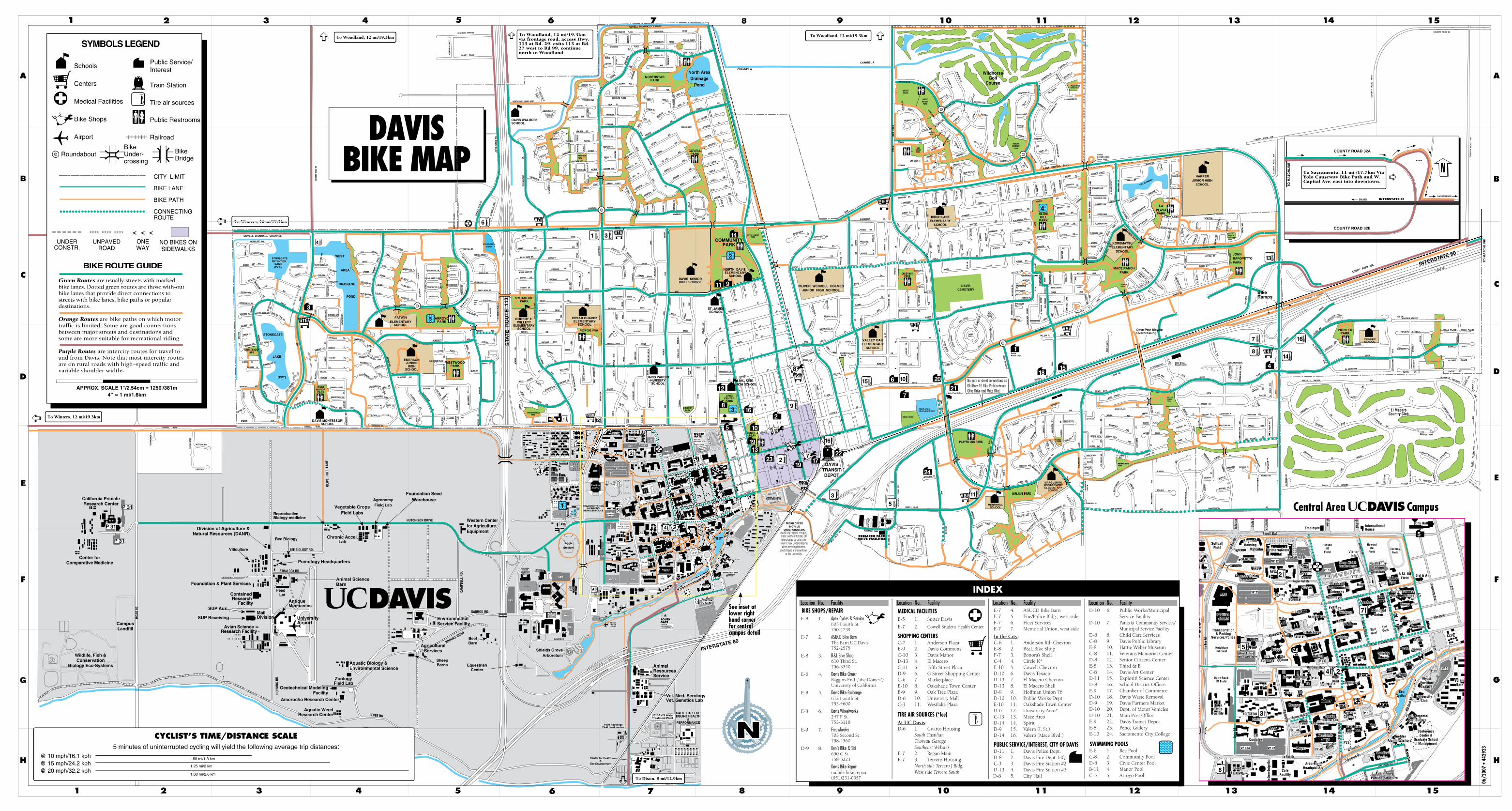
2
3
4
4
5
6
7
DRIVING RANGE
11
12
13
14
15
16
8
9
PRIMERO GROVE
Primero Resident Parking
AGGIE LANE
COTTAGE CIR.
AGGIE VILLAGENEIGHBORHOOD
P 44
.r Dkr aP
dr ahcr O
Western Centerfor AgricultureEquipment
STONEGATE
LAKE
BEACON BAY PL.
MAR
INA CIR
CLE
(PVT)
TRAWLER PL.EVENING BAY PL.
CANOE CT.
WHALER AVE.
HALIFAX
AVE.
HALIFAX AVE.
VICTORIA PL.
HU
BBLE
POR
TSM
OUTH
CUTTER PL.
BERMUDA
SECR
ET B
AY
MARINA
CHESAPEAKE
AVE. JEROME
BISCAYNE BAY PL.
SHELTER COVEMAR
INA
WHALEBACKPARK
SHELTER COVE PL.
WESTMANORPARK
DANUBE AVE.
BRANDYWINE PL.
CUMBERLAND PL.
CIRCLE
LAKE
BLV
D.LAKE
TERRAC
E
GANGES AVE.
PORTAGE BAY WEST
LAKE
CIRCL
E
ST.
CIRCLE
AVE.
BAY
MAGELLAN
ST.
AVE.
ST.
ST.
OYSTER BAY
BLVD
.
SEIN
E
AVE.
WES
TSH
OR
E
TIBER AVE.
ARLINGTON
OTT
AWA
AVE.
RUBICON AVE.
AVE.
ST.
COVELL DRAINAGE CHANNEL
STONEGATERETENTION
BASIN(PVT.)
OYSTER BAY AVE.
SEABRIGHT AVE.
MORRO BAY AVE.
FAR
ALLO
NST
.
BODEGA BAY
DELMAR
WOODS
CIRCLECOHO PL.
AVILA BAY PL.
ST.
ESTE
RO
BAY
BOATHOUSE AVE.
AREA
DRAINAGE
POND
BLVD.
CABO
T
GANGES PL.
FEATHER PL.
EEL PL.
ST.
GAR
RIS
ON
ST.
HATTERAS
WESTERNESSE
PL.
BIEN
VILL
E
SALEM AVE.
EEL AVE.
EASTHU
DSO
NST
.H
UD
SON
C
T.
PORTAGE BAYBUCKLEBURY RD
ELENDIL
CREEKHOLLOW
RIVENDELL
LN
EVENSTAR LN
BREE
LANE
SHIRE LN
LANE
LN
CLEV
ELAN
D
COO
LID
GE
AMADOR
ST.
EISENHOWER
FILLMORE
ALAMEDA
BUTTE PL.
ST.
FILL
MO
RE
ST.
CLEV
ELAN
D
AVE.PL
.
BUCH
ANAN
ST.
ALPIN
E PL.
CT.
AVE.COOLIDGE
ALAMEDA
ARTH
UR
ARTH
UR
S
T.
CT. AVE.
ST.
ADAMS
OXFORD CIRCLE
GU
AVA
LN. FOREST
OXFORD CIRCLEPARK
DR.
STANFORD PL.
PLUM PL.
PL.
STANFORD
LA R
UE R
D.
WAKE
ST. VASSAR DR.
MU
LBERR
Y LANE
HA
WT
HO
RN
E L
N.
LANE
DR.
PEACH SUNSET
AND
ERSO
N
WEST
LIN
DEN
LA
NE
MU
LBERR
Y LANEEIGHTH
SYCAMORE
LN.
PLU
M
LN
.
BURR ST.
ST.
WEST
STA
TE
R11
ET
UO
3
ACAC
IA
LN
.
EL DORADO PLACE
BAR
KLEY
WESTWOODPARK
CALAVERAS AVE.
ARLIN
GTO
N
OVERHILL
EMERSONJUNIOR
HIGHSCHOOL
ROAD
POPPY
MBAD DBE RRY LANE
LN.
LANE
ROAD
ELDNSHIOAKE
STREET
TOPSAIL AVE.
AVE.BRETON
PL.
JERO
ME
ST.
SARATOGA
SHENANDOAH
ISLE
PLACE
PLACE
LASSEN
LANE
BRYCE
LANE
ROYALE
GLACIER DRIVE
DENA
LIDR
IVE
ST. ELIAS
PL
AC
E
PL.
PL.
EVERGLADESPL.
PATWINELEMENTARY
SCHOOL
MUIR WOODS
DRIVESHASTA
PLACE
DINOSAUR
OLY
MO
IC
PL.
COLUSA
COLUSAIMPERIAL AVE.
AVE.
BUR
R ST.
HUMBOLDT
PLACE
AVE.
ST.
GLENN
ST.
AVE.
CORNELL
CHERRY
HARVARD DRIVE
DR.
SYCA
MO
RE
PURDUE DRIVE
MAPLE
LAN
E
SYCAMOREPARK
RO
AD
ROBERT E. WILLETT
ELEMENTARYSCHOOL
BUCKNELL DRIVE
REDWOOD PARK
LIN
DEN
LAN
E
COLBY
VILLANOVABROWN DR.
BROWN DR.
DRAKE DR.
NOTRE DAME DR.
NOTRE DAME DR.
LAN
E
CE
NT
RA
LW
AY
SHARON AVENUE
BARRY ROAD
COURT
SOUTHFIELD
NORTHFIELD
COURT
NORTH DAVIS FARMS ROAD
FALCON AVE
ELK PL.EAGLE PL.
CONDOR CT.VALENCIA ST
REE
T
IMPALA PL.
MAD
RID
CO
UR
T
ANTELOPE AVE.
STREET
CARIBOU BARCELONA
GAZELLE PL.
ALM
ERIA
PAMPLONA
LN.
HACIENDA AVE.
QU
AIL
PL.
MALAGA AVE.
SY
CA
MO
RE
JOH
N J
ON
ES
RD
DR
SE
NOJ
NH
OJ
LY
ND
EL
L T
ER
.
SPAR
RO
W C
T.
HERMOSA PL
ISLA PLKESTREL PL
HARRIER PL
PEREGRINE AVEBLUEBIRD PLACE
CATALINA
GO
SHAW
KST
.KI
TE S
T.
FIN
CH S
T.
MAGPIE
FLAMENCO PL.
AVENUE
HACIENDAPARK
EQUADOR PL.
DIEGO PL. COR
ON
AAVENUECAD
IZ S
T.
BIANCO COURT
CORONA DR.
RO
AD
COURT
BIANCO
SEVI
LLE
ST.
AVENUE
SEVI
LLE
CT.
AVENUEALVARADO
COVELLWEST
KENT
DRAKEDRAKE DR.
FORDHAM DR.
LN.
DRIVE
RADCLIFFE
DR.
DRIVE
APPL
ELA
NE
AND
ERSO
N
FORDHAM DR.
WIL
LOW
LEM
ON
LN.
LN.
RADCLIFFE
BLVD.
HANOVER
VILLANOVA
GEORGETOWN
DRIVE
OR
ANG
E
DRIVE
COVELL DRAINAGE CHANNEL
MERGANSER
SANDPIPER
ROBIN PL
ORIOLE STR
EET
ANDE
RSON
AVOCET AVE
ROAD
HERON PL.
AVE.TAN
AGERW
REN
ST.
PLACEWAXWING
MOCKINGBIRD PLACE
ESTRELLA PL.
DEL ORO
PL.
CORDOVAPL.
BARBERA
FORTUNA COURT
DEL
RAY
CT.
ESPA
NA
CT.
FRANCISCO PL.
ANZA
CATALINA
PL.
AVE.
DR.
CABRILLO
DEL ORO
GRANDE
DRIVE
FIESTA
ENCINA
CAM
INO
CT.
ALVARADO
BEN
ICIA
CT.
BALBOA
AVE.
AVE.
AVE.
HIDALGO
AVE.NORTE
AVE.
IRIS PL.
LAGO PL.
JARDIN PL.
LEON PL.
PL.
INCA PL.
GRANDE
LINDO PL.
AVE.FLICKER
ANZA
GR
OSB
EAK
C
T.
AVE.
MER
CED
ESAV
E.
AVE
CUR
LEW
ST
PLACE
DRIVE
SAN
DPI
PER
DR
IVE
TERN PLACE
PINTAIL PLACE
LUZ
PL.
AVO
CET
AVE
SCHOOL SITE
AMAPO
LA DR
.
BAJA
AVE.ANZA
AVE.
AVE.
AVE.
CORTEZAVE.
AVE.
DIABLO
EL CAJON
AVE.
FARO
GUAYMAS
HUERTA
IPANEMA
COVELLPARK
LOMAALTA
ST.
AVE.
DR
.
AMAR
CT.
AURORAAVE.
ST.CASA
BELL
A
PL.
PL.
ST.
PL.
BUEN
O
ALTO CT.
JALISCOPL.
SOLITO
AVE.
F ST.
SCRIPPS
DRIVE
CITADEL DRIVE
CARO
B PL
.
WEST
DAVIS SENIORHIGH SCHOOL
DRIVE
LANE
TAM
ARAC
K
LAN
E
AVEN
UE
OAK
TOYA
N PL
.
PLACE
DR
IVE
REE
D
REED DRIVE
RUTGERS DRIVE
OESTE
HO
LLYLAN
E
DRIV
E
DRIVE RED
WO
OD
LAN
E
OAK
AVE.
BEEC
HLA
NE
MILLS
DRIVE
DRIVEFOURTEENTH
LAUREL
PL.
NO
RTH
CAM
PUS
WAY
DR
IVE
ANTIOCH
DRIVE
PAR
KSID
E
AVEN
UE
ELM
WO
OD
DR
IVE
DR
IVE
EIGHTH STREETPAR
KSID
E D
RIV
E
AMHERST DRIVE
STREET
PAR
K
DR
.M
ILLE
R
OVE
JAS
AVE.
EUR
EKA
DO
UG
LASS
AVEN
UE
DRIVE
WEST EIGHTH
EUR
EKA
AVE.
OAK
ELM
LAN
E
ELM
WO
OD
COURT
CAMPU
SW
AY
OES
TE
COLL
EGE
PAR
K
SEVENTH
MIL
LER
ST.
A
COLL
EGE
ST.
DR.
EAST
ST.
SHEPHERDS LN.
COLLEGEPARK
SOUTH
A
.
WEST
ST.
ST.TWELFTH
ST.
ASPEN PL.
CEDAR
PL.
SEQU
OIA PL.
LITTLE LEAGUEPARK
NORTH DAVISELEMENTARY
SCHOOL
COMMUNITYPARK
B
ST.
ELEVENTH
D
H
ST.
ST.
F
EIGHTH
ST.
ST.
TENTH
NINTH
ST.
ST.
C
ST.
E
ST.
ST.
B
SEVENTH
ST.
SIXTH
ST.
D
F
FOURTH
UN
IVERSITY
LN.
SECOND
THIRD
THIRDST.
ST.
FOURTH C
D
B
CENTRALPARK
A
FIRST
RICE
ST.
E
CHANNEL A
EAST
CRANBROOKCT.
KENNEDY
MENLO
AUBURN DR.
DREXEL
OLIVER WENDELL HOLMESJUNIOR HIGH SCHOOL
ST.
U P R
R
G
SWEET
COLU
MBI
A
DARTMOUTH
EAST EIGHTH
HUNT
ST.
ST.
PENNSYLVANIA LN.
DOVER CIRBRIAR
PL.
PL.
I
YALE DR.
J
PECAN PL.
PONDEROSA PL.
J
ST.
CEDARPARK
WAY COLGATE
PRINCETON PL.
COVELL PL.
DUKE
ST.
ROWE PL.
ST.
K
ST.
ST.
FIFTH
L
ST.UP R R FOURTH
ST.
ST.
ST.
THIRD
ST.
F
G
ST.
ST.
ST.
ST.
OLIVE
RICHARDS
DR.
HICKORY LN.
U P R R
ST.
BLVD.
80
PUTAH
ST.
ST.
ST.
K
TULANE
DR.
SIM
MO
NS
WAY
CYPR
ESS
L
N.
M.L. KINGHIGH SCHOOL
ST.
DR.
HEM
LOCK
DR
. SPRUCE LN.
DREXEL
JUNIPER PL.
UNION
ALICE
DR.
ST.
LST.
CYPR
ESS
L
N.
HAUSSLER
LN.
PL.
DR.
BLVD.
POLE
DREXEL
DR.
CLAREMONT DR.
PACIFIC DR.
PACIFIC
SPRU
CELN
.
MELLO PL.
LN.
CHANNEL A
AUST
IN S
T
MOORE BLVD.
.
BIDWELL
ST.
FREMONT CT.
DONNER
EL PASO AVE.
AVE.
POLE LIN
E RO
AD
AVE.
GAUGUINPL.
CASSAT
OAKGROVEPARK
VAN GOGH ST.
MANETPL.
AVE.PICASSO MATISSE ST.
BAYW
OO
DLN
AVE.
CEZA
NN
E
REN OIR
CT.
CHAPMAN PL.
MAG
NO
LIA PL.
BIRCH TEMPLE
BATES
PAL
M P
L.
O'KEEFFE PLACE
BENTON PLACE
BAYWO
OD
DENNISON DR.
OLEAN
DER
PL.
LN.
MAD
RO
NEALBION PL.
CHES
TNUT P
L.
LINE
LN.
GENEVA PL.
BIRCH LANEELEMENTARY
SCHOOLDR.
MAD
RONE
PL.
CLARA LN
. WH
ITTI
ER
RD.
DR.
PL.LO
CUST
PL.ALD
ER LN.
BANYAN
PL.
WHITTIER
CLEMSON
LANE
FIG
LN
.
FIG
PL.
NU
TMEG
DR.
DR.
DR.
BUCKEYE
LAFAYETTE DR.
DR. LOYOLA
GEORGIA PL. REGIS
SNYD
ER
CHES
TNU
T
CHESTNUTPARK
DR.
LN.
LAFAYETTE DR.
EAST COVELL BLVD
DR.
PENNY PL.
WAHL WAY
EAST EIGHTH
DR
.
CRAIG
PL.
GR
EGO
RY PL.
LEHIGH
POMONA DR.
LESS
LEY
PL.
ADEL
INE
PL.
M
ST.
DR.
DR.
N
DR.
RD
.
FIFTH
LINE
ST.
ST.
5th STREET
STR
EET
ZAR
AGO
ZA
PRADO
ZAMORA LANE
LANE
MALLORCA
SAN
RAF
AEL
STR
EET
STR
EET
LA C
OR
UN
O
RONDO0 PL
PEPPERDINE
CT.
CAN
TRIL
LD
RIV
E
DEL RIO PL.
TULI
P
LANEMONTEFRIO
LAN
ESA
NTI
AGO
MALLORCA
PON
TEVE
RD
E
PONTEVERDE
LANE
LANE
PEN
A
SECOND ST.
SAN
LAN
E
ST.
SEBASTIAN
JAVIER PL LAN
E
VILL
AVER
DE
PETR
A C
T
SALA
MAN
CA C
T
LAN
E
LANEPONTEVERDE
ADRIAN DR.
BELMONTDR.
BLACKBURN
BLACKBURN
BELMONT
TULIP
DR.
TE
A P
L.
DR.
LN.
MAN
ZANITA
TEMPLE
DR.
LAYTON
DR.
CO
RK
PL
.
BALSAM PL.
MYR
TLE PL.
BELHAVEN PL.
SLIDEHILL
PARK
DR.
CAMPBELL PL.
LN.
GRINNELL DR.
GRINNELL DR.
DR.
LAYTON DR.
LN.
GRINNELL
RAIN
TREE PL.
MO
NAR
CH
COST
A VE
RD
E ST
REE
TCA
RM
ELO
LA
NE
BRYANT PL.
GENARO
PLACECASCADE
LN.
PL.
MO
NAR
CHLN.
LANEVILLA VERDE
HORTALEZALOYOLA DR.CA
MPH
OR
BREN
TWOOD
PL.
DONO
VAN
CT.
ALBANY
CHR
ISTI
ECT
.
BRAD
DO
CKCT
.
ARN
OLD
ST.
CT.
DECATUR
CLARK
CT.
EVANS
AVE.
BOULDER PL.
CONCORD
PL.
AVE.
COWELL BLVD
DR
UM
MO
ND
AVE.
BENBOW CT
BLISS PL.
PARK
LILLARD AVE.
COW
ELL
B
LVD
.
CIR
CLE
FAR
RAG
UT
DR
EW
GALILEO CT.
CONCORD DANBURY CT.
LILLA
RDAV
E.
CT.
VILLAGE
COWELL
RESEARCH
RES
EAR
CHPA
RK
DR
.
NEW
TON
CT.
DA
VIN
CI C
T.
PARK
BLVD.
AV
E.
VALDO
RA
STREET
BARONYPLACE
LA M
ESA
CT.
SAPP
HIRE
CT.
REGATTA LANE
MONTGOMER
Y
RAINIER ST.
LA HABR
A CT.
MONTGOMERY AVE.
RIALTO
LANE
JASMINE
COURT
GAT
EWAY
COU
RT
RIALTO LANE
DONATO LANE
CARMELO LANE
BOLLATE LANE
ALICANTE STREET
ALHAMBRA BLVD.
FLORINDA LANE
FLORINDA LANE
ELIGIO LANE
ALIC
ANTE
STR
EET
LANE
SANTA CRUZ
DRIV
EEL
IGIO
SAN MIGUEL WY
LOYO
LA
PLAC
E
WAY
5th STREET
LANE
SECOND ST.
KOSO STREET
MONO PLACE
MONTEREY
AVE.
LAGUNA AVE.
MIWOK
MAIDU PLACE
PLACE
LA VIDA
CHILES RD
COWELL BLVD
OH
LON
E
BECERRA
EL SEGUNDO AVE.
NANTUCKET
PL.
EL CAMPO
MONTE VISTA
AVE.
SAN
TO
MAS
ST.
LOS
R
OBL
ES
MODOC
LILLARD AVE.
PLACE
LILLARD AVE.
HOOPA PL
POMO
ST
MONTE VISTA
LOS
RO
BLES
ST.
ST.
AVE.
WINTUN PL
EAST OAKSIDE PL.
OAKS
IDE OAKSIDE
ALMOND
PUTAH CREEKPUTAH CREEKPARK
TERR.
NEWPORT
TERR.
COWELL
VISTA
EL MACERO
LAPA
Z D
R.
SAN MARINO
SAN RAMON
LA CANADA
SIER
RAM
ADR
AW
AY
WAY
PL
YANA PL
STREET
WASHOE
WES
T
RD
.
LN.WALNUT
DR.
LN.
TOR
REY ROBINIA
CALMIA PL.DEODARA
ST.
ALMOND
RO
SARIO
DEODARA CT.
MONTGOMERY
WIL
LOW
BAN
K
DR
.
AVE. MONTGOMERY
MEA
DO
WBR
OO
K
NANDINA PL. ST.
PL.
ST.
AMOROSOPL.
LN.
SUNRISE
EL
DR. CT.
BOST
ON
TER
R.
CA
MB
RID
GE
TER
R.
DR.
ASHLAND TERR.
BLVD.
PUMA
DR.
WAY
EL
TO
RO
WAY
CT.
MAC
EB
LVD
.
MACERO
SAN
TAPA
ULA
WAY
DR.
CHILES
RD.
EL M
ACER
O C
T.
GREENVIEWDR.
EL MACEROSOUTH
CLUB
HOUSE
LAKEVIEW
NORTH EL MACERO
ROAD
EL CEMO
NTE
GLIDE
VERANDA TERR.
EL CEMONTE
SWINGLE
DR
.
COWELL BLVD.
PIONEERPARK
HAMEL
AVE
.
MA
CE
BLV
D.
SE
CO
ND
ST.
ALHAMBRA BLVD.
DR.
ST.
DR.EL MACERO
NORTH
AN
GE
LA
ST
RE
ET
SC
HM
EIS
ER
AV
E. BURNETT PL.
PIONEERSCHOOL
COUNTRY
DR.
CLUBDR.
DR. SOUTH
PAR
CIR
CL
E
GO
LF V
IEW
CIR
CLE EL MACERO DR.
FAIR
WA
Y
ESTATESFAIRWAY ESTATES PL.
GARDEN WAY
DR
.
DR
.
CO
UN
TRY CLU
B C
IR.
CA
DD
YC
T.
SAN
DY C
IR.
MIDDLE
GOLF
DR
.
DR.
CLUBHOUSE
EA
ST
EL
MA
CE
RO
EAGLE VIEW CT.
COUNTY ROAD 32A
CHILES RD.
COUNTY ROAD 30B
CO
UN
TY
RO
AD
10
4A
COUNTY ROAD 30
CO
UN
TY
RO
01D
A5
LN
GOLILBO
WEST
EVERGREENPOND
DAVISCEMETERY
DAVISTRANSITDEPOT
Shields GroveArboretum
GARROD RD
Plant PathologyField Headquarters
Center for Health&
The Environment
CALIF. CTR. FOREQUINE HEALTH
&PERFORMANCE
Vet. Med. SerologyVet. Genetics Lab
AnimalResourcesService
EquestrianCenter
Aquatic WeedResearch Center
SheepBarns
BeefBarnBROOKS ROAD
EnvironmentalService Facility
UniversityAirport
AntiqueMechanics
Animal ScienceBarn
Pomology Headquarters
Bee Biology
BEE BIOLOGY RD.Viticulture
ReproductiveBiology-medicine
California PrimateResearch Center
CampusLandfill
RO
AD 9
8
Avian ScienceResearch Facility
Wildlife, Fish &Conservation
Biology Eco-Systems
HO
PKIN
S R
D.
Geotechnical ModelingFacility
Amorocho Research Center
ZoologyField Lab
Aquatic Biology &Environmental Science
AgriculturalServices
Chronic Accel.Lab
Vegetable Crops Field Labs
AgronomyField Lab
Foundation SeedWarehouse
HUTCHISON DRIVE
CAM
PBEL
L R
D.
GARROD RD.
STRALOCK RD.
OLI
VE T
REE
LAN
E
LEVEE RD
CESAR CHAVEZELEMENTARY
SCHOOL
NORTHSTARPARK
ST. JAMESSCHOOL
DAVIS PARENTNURSERYSCHOOL
DAVIS WALDORFSCHOOL
DAVIS MONTESSORISCHOOL
RED
WO
OD
VALLEY OAK ELEMENTARY
SCHOOL
Central Area Campus
LAPLAYAPARK
TALLOW PL.
HACKBERRY PL.ALBANY
ALBANY
HAL
SEY
CIR
.
PLAYFIELDS PARK
INTERSTATE 80
PINE
LN.
See inset at lower right hand corner for central campus detail
BikeRamps
ARROYOPARK
DR
IVE
COU
NTY
RO
AD 9
9
CONQUISTADOR DR.
LA PLAYA DR.
ARENA DR.
OCE
ANA
DR
.
GAVIATO PLACE
LOS CERROS PLACE
EL VALLE PLACE
ESTA
BAN
CT..
CACE
RES
CT.
.
ESCO
LAR
CT.
MAD
ERA
CT.
SAN
TAN
DER
CT.
VIG
OCT
.
FRONTERA
PAST
ALW
AY
KEN
DAL
LW
AY
IP
AC
LE
TS
NA
T.
RIO GRANDE ST.
RUSHMORE LN.
CARLSBAD PLACE
POINT REYES PLACE
TAHOE PLACE
LP
RE
TT
US
AC
E
LAKE ALHAMBRA
AREN
A DR
.
LA PLAYA DR.
CHALUPA PL.
FeedLot
Foundation & Plant Services
Center forComparative Medicine
WISTERIA WAY
LARUE WAY
PATW
INRO
AD
TIER
RA L
INDA
PL.
RUSSELL BLVD.RUSSELL BLVD.
PINN
ACLE
STCOLORADO LN
PINNACLE PL
DeSOTO PL
YTN
UO
CR
O03
DA
B
SHASTA
INNER
MADSON PL
CIRCLE
HIDDEN
CIR.
N.DI
AMET
ER D
R.
NAVAJO ST.NAVAJO ST.NAVAJO ST.
PISMOCT.
POPORTOLA CT.
JOSHUA TREE ST.
CCCRRYSYSTTAL GR
OVE LN
AL GR
OVE LN
AL GR
OVE LN
TAL GR
OVE LN
TTAL GR
OVE LN
T..
SANTA ROSA ST.
SANTA
ROSA
S
TA R
OSA S
T
T.
CAPECODCT.
CAPE COD ST.CAPE COD ST.
HAMPTON DR
HAMPTON DR
HAMPTON DR
HAMPTON DR
HAMPTON DR.
VANDAMME DR
VANDAMME DR
V
.
YUKO
N ST.
PORTOLA ST.
ADAMS
TO M
AT
CH
LIN
AT
CH
LIN
AE
ALH
AMBR
A D
R.
MERCED DR
ARENA DR. VELA PL
HALCON PLHALCON PL
CONCHA PLCONCHA PL
ASCADA PL. ASCADA PL. ASCADA PL. ASCADA PL. ASCADA PL.
OCEAN
OW
AYAYA
WELLESLEY PLWELLESLEY PLWELLESLEY PLWELLESLEY PL.
KALAMAZOOPL.
MES
QU
ITE
DR
.
SYRACUSECT.CT.
GRAMBLING CGRAMBLING CT.
MES
QU
ITE
DR
.
GR
EE
NE
TE
RR
TE
RR
TE
RR
TE
RR
TE
RR
TE
RR
TE
RR
.
EXETER C
T.T.T
EVER
GREEN C
T.
MAR
IPOS
A CI
R.
EL PESCADOR
CT.
LALAPALOM
A CPALOM
A CP
T.
MORRIS LN.
GAYAYA WAYAYA
HARVEYHARVEY WAYAYA
LYLELYLEL WAYAYA
ARTIS LN.
LOU
ISE LN.
HEDYLN.
DR
EW CIR
.
ELDERBERRY PL.
DR
UM
MO
ND
SOU
TH
REDBUD DR.
PISTACHIO
CTACH
IO C
TT.
COTT
ON
WO
OD
DR
COTT
ON
WO
OD
DR
.
COTTONWOOD CT.REDBUD PL.
BOXELDER PLBOXELDER PLBOXELDER PLBOXELDER PL.
DOGWOOD PL.DOGWOOD PL.DOGWOOD PL.
COLO
NNA
TERR
TERR
.
EN
SE
NA
DA
➪
To Winters, 12 mi/19.3km
To Winters, 12 mi/19.3km
06/2
007
• 44
2923
TRINITRINITTATATTERRTERR.
SAN GALLO
TERR.
VIA VERDI TERR..
VIA DELSOL TERR.
VISTOSA ST.VISTOSA CT.
ALEGRE WAYAYA
CARICIA D
RCAR
ICIA DR
. CAMCAM
PANILL
PANILL
PA
CCCT.LADER
A CT.
CRESTA C
TA CT
T.
ARR
OYO
AVEAVEA
.
VALEROSA
VALEROSA
V
WAYAYA
ALEG
REW
AYAYA
ENTRADA DR.
ARROYOARROYOARROYOARROYO AAVEVEAVEA .
COLINA CT.
BENDITATAT
CT.ARROYO CARROYO CARROYO CT.
WAY
To Woodland, 12 mi/19.3km ➪ To Woodland, 12 mi/19.3km via frontage road, access Hwy. 113 at Rd. 29, exits 113 at Rd. 27 west to Rd 99, continue north to Woodland
To Woodland, 12 mi/19.3km
➪
To Dixon, 8 mi/12.9km
3820 Chiles Road Facility
POLE
CORE AREA DRAINAGE POND
DOG PARK
FULL CIRCLE
BROKENCIRCLE
OUTERCIRCLE
S. DIAMETER
FULLCI
RCLE QU
ARTE
RCI
RCLE
P 31
P 31
P 31
MARDEN STREET
ROGERS STREETHOAG PLACE HOAG PLACE
COWELL BLVD.
Ramps
BONNARD
SPAFFORD CT.
COU
STEA
U P
L. RO
OS
DR
ES
BA
CH
WildhorseGolf
Course
North Area Drainage
Pond
PO
PL
AR
PL
.MERRYHILL
SCHOOL
El MaceroCountry Club
WES
TCH
ILES
RD
GUTHRIE PLACE
TUFTS ST.TUFTS ST.
Dave Pelz Bicycle Overcrossing
MARGUERITEMONTGOMERYELEMENTARY
SCHOOLWALNUT PARK
SANDYMOTLEY
PARK
NUGGETFIELDS
HARPERJUNIOR HIGH
SCHOOL
KOREMATSUELEMENTARY
SCHOOL
MACE RANCH PARK
JOHNBAROVETTOPARK
MACERANCHMINI PARKL
ST.
L
RESEARCH PARKDRIVE FACILITIES
Aggie
Stadium
SCHAALAQUATICCENTER
SCHAALAQUATICCENTER
GENOME &BIOMED SCIGENOME &BIOMED SCI
WESTERNHUMAN
NUTRITIONRESEARCH
CENTER
WESTERNHUMAN
NUTRITIONRESEARCH
CENTER
ARC
Pavilionat ARC
VP 56
VP 50
VP 49
VP 47A VP 47
P 42 P 43
P 46
VP 48
VP 40P 41
VP 55
VP 51
VP 53
VP 57
P 41
P 3
TRANSPORTATION& PARKING
SERVICES/POLICE
UC DAVIS WaterTreatment Plant
THURMAN
TUPPER
Vet MetTeachingHospital
CCAH
VET MEDLAB FAC
West EntryParking
Structure
IDE DR.
ATL
AN
TIS DR.
WOODBRIDEGEPARK
WILLOWCREEKPARK
ALBANY CIR.
WILDHORSEMINI PARK
ContainedResearch
FacilitySUP Aux
SUP ReceivingMailDivision
Division of Agriculture &Natural Resources (DANR)
DavisPolice Dept.
Main Post Office
1 2 3 4 5 6 9 10 11 12 13 15
1 2 3 4 5 8 9 10 11 13 1512
14
6 7 14
7 8
A
B
C
D
E
F
G
H
A
B
C
D
E
F
G
H
THE COLLEGESAT LARUE
THE COLLEGESAT LARUE
Segundo DiningCommons
Segundo DiningCommons
Segundo HousingSegundo Housing
TB 174
LAKESPAFFORD
ACADEMICSURGE
Meyer
Kemper
Bainer
North Entry
Parking
Structure
CIVICCENTER
PARK
INTERSTATE 80
PUTAHCREEKLODGE
Plant andEnvironmental
SciencesVP 35VP 25
VP 22
P 20
VP 16
VP 17
VP 15
P 14 P 14
VP 30
ORCHARD PARK
HUMANRESOURCES
Shield
Library
West
Quad
East
Quad
BIKE LANE
BIKE PATH
Schools
Centers
Medical Facilities
Bike Shops
Airport
SYMBOLS LEGEND
Public Service/Interest
CITY LIMIT
Train Station
Tire air sources
Public Restrooms
Railroad
BikeBridge
CONNECTINGROUTE
UNDERCONSTR.
NO BIKES ONSIDEWALKS
INTERSTATE 80
LEVEE
SACRAMENTO
DAVIS
TO M
AT
CH
LIN
AT
CH
LIN
AE
COUNTY ROAD 32A
COUNTY ROAD 32B
BIKE ROUTE GUIDE
Green RouteGreen RouteG sreen Routesreen Route are usually streets with markedbike lanes. Dotted green routes are those with-outbike lanes that provide direct connections tostreets with bike lanes, bike paths or pr pr opulardestinations.
Orange Routes are bike paths on which motor traffic is limited. Some are good connections between major streets and destinations and some are more suitable for recreational riding.
Purple Routes are intercity routes for travel to and from Davis. Note that most intercity routes are on rural roads with high–speed traffic and variable shoulder widths
APPROX. SCALE 1"/2.54cm = 1250'/381m4” ≈ 1 mi/1.6km
DAVISBIKE MAP
CYCLIST’S TIME/DISTANCE SCALE5 minutes of uninterrupted cycling will yield the following average trip distances:
@ 10 mph/16.1 kph@ 15 mph/24.2 kph@ 20 mph/32.2 kph
.80 mi/1.3 km
1.25 mi/2 km
1.60 mi/2.6 km
➪To Sacramento, 11 mi /17.7km Via Yolo Causeway Bike Path and W. Capital Ave. east into downtown.
NRoundabout
BikeUnder-crossing
UNPAVEDROAD
ONEWAY
ELM
LAN
CAMPU
S
COLL
EG A
CENTRALPARK
21
2223
i
BUEHLER ALUMNI/VISITORSCENTER
VISITORINFORMATION& ASSISTANCE
SOUTHGATE
MONDAVICENTER FOR
THE ARTS
SOUTH ENTRYPARKING
STRUCTURE
j
VISITORINFORMATION&ASSISTANCE
NORTHGATE
South EntryParking Structure
ArboretumHeadquar
ColeFacility
Rec Pool
LA RUEPARK
SoftballField
ARCBasketball
Courts
FleetServices
Dining
DairyCattle
Facility TERCERO
CRComplex
CEF
PolicePolice
FireFire
Ryerson
SegundoHousing
Malcolm
SEGUNDO
GilmoreBixby
Segundo DiCommons
REGAN
ousingce
FoodScience
Cruess
oagland
MannLab
Asmundson
Hutchison
Haring
SciLab
Surge Buildings
ysics/Geology
III II
I IV
SiloBikeBarn
South Silo Chemistry
Ever
yb
essBainer
KemperII
neeringIII
Meyer
AcademicSurge
FacilitiesServices
PSE
King
Mrak
Wright
ArtMusic
Sproul
AOB4
OlsonShieldsLibraryWalker
Briggs
iber Storer
LifeSciences
SciLecture
Leach
CowellStudentHealthCenter
Primero Grove
MondaviCenter
BuehlerAlumni/Visitors
EnvironmentalHorticulture
UniversityClub
SolanoPark
CCFS
VoorhiesSouthHall
rtHall
Young
BookStoreFreeborn
MemorialUnion
Wickson
Veihmeyer
Plant andEnvironmental
Sciences
Hunt
HickeyGym
VisitorInfo
North EntryParking
StructureA St. IM
Field3rd & A
KerrWellman
RobbinsHart
Social Scienceand Humanities
Dutton
Dairy RoadIM Field
CrockerNuclear Lab
CrockerNuclear LabData
Center
ToomeyField
HowardIM
Field
RussellIM
Field
HutchisonIM Field
istr
AdmissionsAdmissions
Sac CityCollege
Davis Ctr.
Athletic Annex
Guilbert
City HallInternationalHouse
EmployeeHealth
SchaalAquaticCenter
West EntryParking Structure
TheBarn
ConferenceCenter &
Graduate Schoolof Management
Pavilionat ARC
Marya WelchTennis Center
Transportation& Parking
Services/Police
WatershedSci
WatershedSci
Giedt
South EntryParking Structure
ArboretumHeadquar
ColeFacility
Transportation& Parking
Services/Police
Rec Pool
LA RUEPARK
SoftballField
ARCBasketball
Courts
FleetServices
Dining
DairyCattle
Facility TERCERO
CRComplex
CEF
PolicePolice
FireFire
Ryerson
SegundoHousing
Malcolm
SEGUNDO
GilmoreBixby
Segundo DiCommons
REGAN
ousingce
FoodScience
Cruess
oagland
MannLab
Asmundson
Hutchison
Haring
SciLab
Surge Buildings
ysics/Geology
III II
I IV
SiloBikeBarn
South Silo Chemistry
Ever
yb
essBainer
Kemper
neeringIII
Meyer
AcademicSurge
FacilitiesServices
PSE
King
Mrak
Wright
ArtMusic
Sproul
AOB4
OlsonShieldsLibraryWalker
Briggs
iber Storer
LifeSciences
SciLecture
Leach
CowellStudentHealthCenter
Primero Grove
MondaviCenter
BuehlerAlumni/Visitors
EnvironmentalHorticulture
UniversityClub
SolanoPark
CCFS
VoorhiesSouthHall
rtHall
Young
BookStoreFreeborn
MemorialUnion
WicksonEnology
Veihmeyer
Plant andEnvironmental
Sciences
Hunt
HickeyGym
VisitorInfo
North EntryParking
Structure3rd & A
KerrWellman
RobbinsHart
Social Scienceand Humanities
Dutton
SchaalAquaticCenter
ConferenceCenter &
Graduate Schoolof Management
West EntryParking Structure
WyattPavilionTheatre
WyattPavilionTheatre
Pavilionat ARC
Marya WelchTennis Center
TheBarn
Giedt
EmployeeInternationalHouse
City Hall
Hutchison Dr.Hutchison Dr.
La Rue Dr.
Old Davis Rd.
Kleiber.
ter J. Shields Ave.
Mr
oretum
.dRegdoL keer C hat uP
Biolet
ti Wy.
Bainer Hall Dr.
.dReuR aL
La Ru
e Rd.
Russell Blvd.
.dRnosrednA
.rDetseO
.yWsupmaC.S
. evA
kaO
kraP
egel l
oC
California Ave.
.evA
ainro
filaC
Howard Wy.
WestQuad
West Quad Ave.
East Quad Ave.
EastQuad
A St.
A St.
University Ave.
B St.
North Quad Ave.
Regan Hall Dr.
Beckett Hall Dr.
Orchard Rd.
Old D
avis
Rd.
epafford
Rice Lane
Beau Vine Lane
r oretum Dr.
DataCenter
HoHoHoHowward ard ard ard WWWWyyyy
s
A St.
4
5
2
3
6
2
2
. dR yri aD
M
PPPPPPPPPPa
dddd
retum
son Dson D
rrrn
BBBiii
7
OlOlOlddd D D Davavis is is RdRdOlOlOlddd D Davavis is RdRd..
BBB
VP 47A VP 47
VP 44
VP 46
P 3
P 43
P 29
VP 25
VP 22
VP 15
P 14 P 14
VP 5P 5A
BISHOP PL.
HOPPER PL.
AUDUBON CIR.
KLEE P
L.
RIVERA PL.
HA
HAR
TLEYY
ST.
WYE
TH C
T.SL
OAN
ST.
RODIN PLRODIN PLRODIN PLRODIN PL.
BOTTICELLI PL
BOTTICELLI PL
BOTTICELLI PL
BOTTICELLI PL
BOTTICELLI PL
BOTTICELLI PL
BOTTICELLI PL
BOTTICELLI PL
BOTTICELLI PL
BOTTICELLI PL
BOTTICELLI PL
BOTTICELLI PL
BOTTICELLI PL..
LEONARDO C
LEONARDO C
LEONARDO C
LEONARDO C
LEONARDO C
LEONARDO C
LEONARDO CTTT.
TITI
AN P
L
TITI
AN P
L
TITI
AN P
L
TITI
AN P
L.M
ICHE
LANG
EL
MIC
HELA
NGEL
MIC
HELA
NGEL
MIC
HELA
NGEL
MIC
HELA
NGEL
MIC
HELA
NGEL
OPLPL
. LEONARDO
ST.
RAPHAEL PL.
SISLEY CT.
RODI
N PL
.
SARG
ENT
CT.
POLLOCK
CT.
CALDER CT.
MOORE BBLVDVDLVDL ..
WRIGHT B
WRIGHT BLVD
LVDL
.
ROCKWELL DR.
ROCKWELL CT.
DUCHAMPP
ST. BELLOWS CT.
BELLOWS ST.
CARAVAVA AGGIO PLVAGGIO PLV .
MO
OR
E BM
OO
RE BLVD
LVDL
.
HEPWORTH DR.
DALI P
L.
NEVELSON CNEVELSON CT.
KLINE CKLINE CKLINE CT.
BERNINI ST.
CARA
VAVAAG
GIO
DR
VAGG
IO D
R
V
.
BONNARD
ST.
HENRI CT.
BEAR DEN ST.
CARAVAVA AG
GIO
DR
VAGG
IO D
RV
.
ROCKWELL DR.
AUDUBON CIR.
ROCKWELL DR
ROCKWELL DR
ROCKWELL DR
ROCKWELL DR.
ROBERTARNESON
PARK
AVE
AgriAgriAgricccSerSer
AgriAgriccSer
ulturturl
Service Facility
See inset at
A St. IMField
1
2
9
4
5
7
14
16
8
5
16
10
8
12
13
17
2
1
9
11 5
3
10
7
1
11 9
14
3
618
20
21
2419
7
8
2
2
15
4
3
23
4
12
43
7
2
1
6
22
15
1619 3/6
1/5
610
1
REC POOL
1
8
N
2
3
4
3
6
7
2
5
11
5
13
4
UnderConstructionOpen 2008
5
No path or street connections on Old Hwy 40 Bike Path between Olive Drive and Mace Blvd.
PUTAH CREEKBICYCLE
UNDERCROSSINGAvoid high-speed mergingtraffic on the Interstate 80interchange by using the
Putah Creek Undercrossingwhen traveling between
south Davis and downtownor the University.
INDEX
BIKE SHOPS/REPAIRE-8 1. Apex Cycles & Service
603 Fourth St.750-2739
E-7 2. ASUCD Bike BarnThe Barn UC Davis752-2575
E-8 3. B&L Bike Shop610 Third St.756-3540
E-6 4. Davis Bike ChurchBaggins End (“the Domes”)University of California
E-8 5. Davis Bike Exchange612 Fourth St.753-4600
E-8 6. Davis Wheelworks247 F St.753-3118
E-9 7. Freewheeler703 Second St.758-4560
D-9 8. Ken’s Bike & Ski650 G St.758-3223
Davis Bike Repairmobile bike repair(951)231-0357
MEDICAL FACILITIESB-5 1. Sutter Davis
E-7 2. Cowell Student Health Center
SHOPPING CENTERSC-7 1. Anderson PlazaE-9 2. Davis CommonsC-10 3. Davis ManorD-13 4. El MaceroC-11 5. Fifth Street PlazaD-9 6. G Street Shopping CenterC-6 7. MarketplaceE-10 8. Oakshade Town CenterB-9 9. Oak Tree PlazaD-6 10. University MallC-3 11. Westlake Plaza
TIRE AIR SOURCES (*fee)At UC Davis:D-6 1. Cuarto Housing
South CastilianThoreau GarageSoutheast Webster
E-7 2. Regan MainF-7 3. Tercero Housing
North side Tercero J Bldg.West side Tercero South
E-7 4. ASUCD Bike BarnE-7 5. Fire/Police Bldg., west sideF-7 6. Fleet ServicesE-7 7. Memorial Union, west side
In the City:C-6 1. Anderson Rd. ChevronE-8 2. B&L Bike ShopF-7 3. Bonora’s ShellC-4 4. Circle K*E-10 5. Cowell ChevronD-10 6. Davis TexacoD-13 7. El Macero ChevronD-13 8. El Macero ShellD-9 9. Hoffman Union 76D-10 10. Public Works Dept.E-10 11. Oakshade Town CenterD-6 12. University Arco*C-13 13. Mace ArcoD-14 14. SpiritD-9 15. Valero (L St.)D-14 16. Valero (Mace Blvd.)
PUBLIC SERVICE/INTEREST, CITY OF DAVISD-11 1. Davis Police Dept.D-8 2. Davis Fire Dept. HQC-3 3. Davis Fire Station #2D-13 4. Davis Fire Station #3D-8 5. City Hall
D-10 6. Public Works/MunicipalService Facility
D-10 7. Parks & Community Services/Municipal Service Facility
D-8 8. Child Care ServicesC-8 9. Davis Public LibraryE-8 10. Hattie Weber MuseumC-8 11. Veterans Memorial CenterD-8 12. Senior Citizens CenterE-8 13. Third & BC-8 14. Davis Art CenterD-11 15. Explorit! Science CenterD-8 16. School District OfficesE-9 17. Chamber of CommerceD-10 18. Davis Waste RemovalD-9 19. Davis Farmers MarketD-10 20. Dept. of Motor VehiclesD-10 21. Main Post OfficeE-9 22. Davis Transit DepotE-8 23. Pence GalleryE-10 24. Sacramento City College
SWIMMING POOLSE-6 1. Rec PoolC-8 2. Community PoolD-8 3. Civic Center PoolB-11 4. Manor PoolC-5 5. Arroyo Pool
Location No. Facility Location No. Facility Location No. Facility Location No. Facility
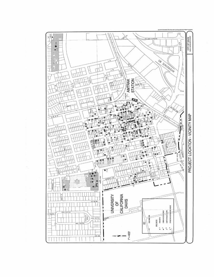
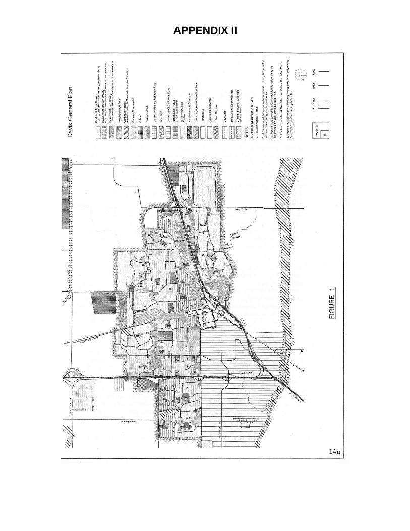
APPENDIX II
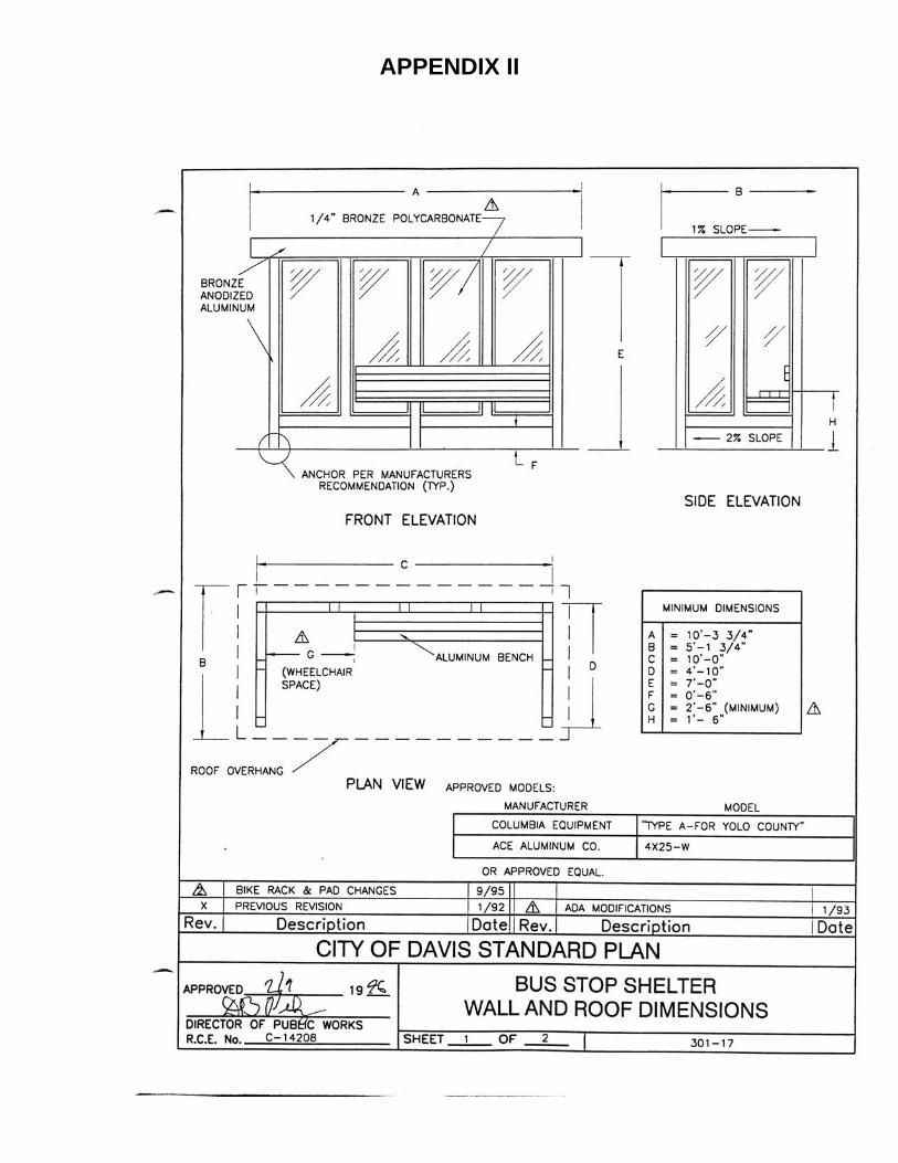
APPENDIX II
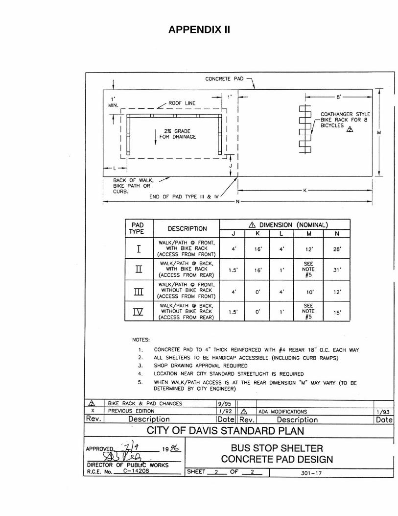
APPENDIX II
III
Appendix III. Bicycle Facilities Design Guidelines
page intentionally left blank
BICYCLE FACILITY GUIDELINES The City of Davis has been developing bikeways for nearly 40 years. During this period, bicycle use as a primary mode of transportation has steadily continued to increase. The most recent census figures indicate that approximately 17 percent of all trips in Davis are made by bicycle. As the cycling population continued to grow, the bicycle transportation network continued to grow and evolve as well. The development of the city's bicycle transportation system over the years, and the lessons learned during that time, have helped to evolve a set of bicycle facility planning principles that have served the city well. Additionally, the standards that have been developed have benefited other jurisdictions within the state as well as other parts of the country. In order to ensure these systems are functioning as safely and as efficiently as possible, procedures to effectively resolve bicycle circulation and safety issues have been institutionalized so that these issues are dealt with routinely. CYCLIST POPULATION The bicycling population in Davis is comprised of wide and diverse segments with differing skills and abilities, as well as differing motivations for cycling in the first place. The type, location, and characteristics of bicycle facilities must necessarily take into account these segments of drivers if they are to be served adequately. A given set of bicycle facilities and routes will not be suitable for the entire cycling population. The following list is one attempt to classify this population into identifiable categories: 1. Avid cyclists. Considers the bicycle as the primary
transportation mode for most trips. The availability of direct, high speed routes that are relatively unfettered by traffic lights and stop signs is important. The avid cyclist will often choose to ride in the motor vehicle travel lane, and along major routes without separate bicycle facilities. This group of experienced cyclists will typically shun separated bike paths, particularly in neighborhood greenbelts. Avid cyclists are highly attuned to bicycle safety, so they are sensitized to potential hazards, and they continually anticipate and avoids compromising situations while riding. This group, although typically the most visible and
vocal component of the bicycling community, is actually a relatively small segment of the cycling population.
2. Regular bicycle riders. This group of cyclists will typically
utilize a bicycle as a preferred transportation mode, provided that the destination is reasonably close and a good bicycle route exists. The individuals in this group are usually working adults, UCD students, or mature high school students. This group also includes parents with child seats/carts. They appreciate the relative speed and convenience of the bicycle as compared to the car. These cyclists desire safe and efficient bicycle facilities and routes. They are willing to accept some out of direction travel to avoid perceived hazardous locations. Some cyclists in this group feel uncomfortable riding along high speed arterial streets even when bike lanes are provided. They are usually attuned to potential hazards such as opening car doors, and cars exiting or entering driveways. The regular bicycle rider wants to maintain momentum but usually obeys traffic controls. This type of cyclist comprises a large segment of the cycling population in Davis
3. Young regular bicycle riders. This is usually a child of junior
high or high school age who routinely rides to and from school. Other trip purposes include riding to visit friends, to the park, to shop, and for other after school activities. This group of cyclists tends to have less experience negotiating traffic, so they are not always aware of potential hazards. They may choose routes unsuitable to their ability, and they often disobey traffic laws and traffic control devices. This group of cyclists tends to prefer the shortest route possible, because minimal pedaling effort seems more important than speed, and they tend to prefer bike lanes and bike paths. In Davis, this is a large segment of the cycling population.
4. Beginning bicycle rider. These are school age children up to
about the fourth grade level. They ride bikes to and from school only if a route exists consisting of bike paths and bike lanes on streets with relatively low traffic volumes. Beginning bike riders will typically only pedal to destinations in their neighborhood, and they seldom ride bikes across town. They are not “little adults” as some people seem to think, but individuals within the bicycling community that have very real experiential and physiological limitations. Cycling skills are not fully developed in this age group, and most of them have relatively limited experience riding a bike in traffic. Developmentally, this age
group has physical limitations as well. Up to about age nine or ten, most children do not have well developed peripheral vision, and they have difficulty with concepts such as closure speed (e.g. approaching motor vehicles). Younger bicycle riders typically have difficulty following a straight track, and they frequently weave from side to side when riding. Beginning bike riders are a relatively smaller segment of the cycling population.
There are other ways that cyclists can be categorized, such as by trip purpose. The descriptions detailed above only serve to represent the major categories of cyclists in Davis, but they do not imply that the categories are exclusive, or the descriptions absolute. ROUTE SELECTION Route selection factors commonly used by bicycle facility planners include factors such as: Rider Safety - Routes are chosen considering various safety
factors, including traffic volumes, motor vehicle speeds, shoulder width, and the presence of parked cars.
Rider Convenience - Convenience factors usually considered
include most destination points, fewest stop signs, most side streets with stop signs, and least debris on shoulders.
Rider Volume - Emphasis placed on limiting the number of
bikeways designated in order to concentrate on bikeways with the highest bicycle volumes.
Selection criteria such as the above would result in too limited a bikeway system to adequately provide for the cycling population in Davis. In order to increase the already high use of bicycles, it is necessary to provide adequate routes for all segments of the cycling population. These routes must serve all combinations of origins and destinations across the city. This cannot be done by designating and developing a skeleton of high priority bike routes. The existing and future street and bicycle networks are planned to safely and adequately provide for bicycle circulation. Bike lanes exist or are planned along all arterial and collector streets. In addition, Class I bicycle facilities are provided in neighborhood greenbelts and along high demand bicycle corridors. A more austere circulation system would not meet the goal of providing safe and convenient bicycle access to all areas of the city. ROUTES SELECTED The bikeway system is shown on the City Bikeway Map (please see Appendix 7). Both existing and planned facilities are shown. The planned facilities serve to augment the existing system, correct specific deficiencies, and extend the network to newly developing areas. Several features of the System are worthy of note: - Bike lanes are shown along all arterial and collector streets
(with the exception of Fifth Street west of Pole Line Road). - Grade separated facilities are provided to facilitate crossing of
busy streets and highways. - Class I facilities (bike paths) are provided within neighborhood
greenbelts. - Class I facilities are shown to provide alternative facilities to
using on street bike lanes along high traffic routes. - Continuity of the system is important and wherever possible,
all facilities are joined in a network providing continuous service for cyclists.
Since this bikeway system extends throughout the City, it accommodates the commuting needs of employees, shoppers, faculty and students regardless of the trip origin or destination. These
facilities are included as part of the normal street design and construction process. Land use adjacent to bikeways includes all the land uses within the city. Since the policies contained in this plan require integrated bikeways throughout the city, all land uses and combinations of bicycle trips are accommodated. Land use designations in the City of Davis are contained within the General Plan and the various other plans and maps maintained for that purpose. See Figure 1 (page 13a) for a general picture of land uses. For specific land use designations adjacent to bikeways, reference is made to those documents.
ENGINEERING STANDARDS & GUIDELINES
STATE DESIGN STANDARDS Chapter 1000 of the CALTRANS Highway Design Manual is the guiding reference for planning and design of bikeways. The cases where City of Davis guidelines are more stringent are identified below. It must be emphasized that a careful evaluation of conditions for a specific bikeway may justify an easing of some requirement or necessitate a more stringent requirement, as the case may be, for the appropriate reasons. Therefore, these guidelines are not absolute standards but rather a guide to be used as a point of beginning when planning new facilities or improving performance of existing facilities. BICYCLE FACILITIES DESIGN A. Design speed The selected design speed of a bikeway facility is the single criterion that dictates facility geometry to result in safe bikeways. Therefore, the selected design speed for a bikeway segment should be the uppermost speed expected for the bulk of riders using the facility. The design speed for bikeways within the City of Davis is 20 MPH. For downhill grades exceeding 4 percent, the design speed is increased to 30 MPH. B. Grades For most facilities, sustained grades should not exceed two percent if a wide range of riders is to be accommodated. However, undercrossings and overcrossings cannot be limited to this grade criterion however, due to the vertical rise that such structures typically require. Fortunately, the city landscape is nearly flat in most areas, thereby eliminating grade limits as a significant design parameter except for grade-separated crossings. The safety of a given grade is based on criteria for stopping sight distance, which, in turn, is dependent upon grade and design speed. Much of the literature suggests that grades should be kept to 5 percent or less where possible. The reasons for this are that cyclists may avoid facilities with steeper grades, or that some cyclists may be unable to negotiate the grade due to physical limitations. Aside from the practical aspects of minimizing grades whenever possible, the Americans with Disabilities Act (ADA) prohibits the construction of facilities steeper than 5 percent to ensure access to individuals with disabilities. There are two primary safety issues with steep grades. If overcrossing grades are too steep, cyclists may seek an alternative at-grade crossing at an unsafe location to avoid the effort of using the overcrossing. For
undercrossings or bike tunnels, if the grades are too steep, cyclists may choose to attain unsafe speeds while descending in order to gain momentum to negotiate the ascending grade. Other than these two situations, steeper grades do not create safety problems while ascending or descending, provided adequate stopping sight distance is maintained. Of course, factors such as debris on the roadway, weather, and the mechanical condition of the bike also have an effect on stopping distance. Another factor to consider about grades is the distance that a given grade persists. The acceptability of a relatively steep grade depends on the length of the grade. Steep grades are tolerable for relatively short distances and are preferable as an alternative to much lesser grades that last long distances. C. Grade Separated Crossings This plan provides for some grade separations where separated bike paths cross arterial streets and highways. Such crossings are planned to provide for relatively unimpeded bicycle routes interconnecting all areas of the city and the University. Additionally, grade separated crossings afford continuity along neighborhood greenbelt bike paths by eliminating the need to cross arterial streets at grade. 1. Undercrossings The preferred grade separation is the undercrossing because it allows shorter and flatter approaches than an overcrossing. However, close attention to the design is needed because of the bicyclist’s tendency towards excessive speed in an effort to contend with the adverse ascending grade. Therefore, approaches should be kept to no more than 5 percent grade. In addition, the roadway should be raised so that the upper portion of the bicycle tunnel is above the elevation of the surrounding terrain. This design approach usually allows relatively short approaches of modest grade thus moderating the tendency to excessive speed in the tunnel. In addition, this design feature may allow drainage to be accomplished by gravity. Undercrossings shall be fully lighted for safety. Finally, visibility into and through a raised tunnel enhances the sense of safety compared to a deeper structure with less visibility.
2. Overcrossings Overcrossings are generally needed where roadway curb-to-curb width exceeds about 90 feet due to concerns of personal safety. Steep grades should be moderated as much as possible so that ridership is not unduly discouraged. Grades exceeding 4 percent for downhill travel do not, by themselves, create a safety problem, provided that safety criteria derived from the 30 MPH design speed are followed. For ascending cyclists, a combination of length and grade should be selected that carefully balances the two as necessitated by the total climb required. Short, steep grades are preferable to modest grades of 2-4 percent, if those modest grades must persist for distances significantly in excess of 500 feet. D. Typical Cross Sections Lesser widths may be considered for low volume streets/paths, existing roadways narrower than city standards, or where other circumstances warrant. State bikeway standards shall be considered the absolute minimum.
E. Intersection Considerations Intersections are the problematic locations where many bicycle/auto conflicts occur. Skilled cyclists usually have little problem making the appropriate transitions when using on-street lanes. Lesser skilled bike riders may have difficulty performing weaving maneuvers near intersections safely. These bicycle drivers need alternate, less demanding routes as an alternative to using the on-street bike lanes. When using such alternate routes, the cyclist will still need to cross busy arterial streets, usually at signalized intersections. Special loop detectors, which can detect bicycles, as well as bicycle oriented signal call buttons can all facilitate the crossing. Bicycle routes typically used by younger children need to provide protected signalization for crossing major streets, both at intersections and at other locations where crossings are needed. Grade separated crossings are an alternative to protected at-grade crossings. Such crossings tend to be very expensive, which limits where they can be considered to only a few high priority locations. Neither bike overpasses nor underpasses work well near intersections. The crossing length is longer and there is not the opportunity to adjust the road grade to shorten the slopes of the crossing. Also, the transitions between on-street lanes and the separate crossing path create the possibility of unsafe movements. Underpasses can prompt personal safety concerns if their required length is too great and/or visibility through the underpass is limited. Research has shown that the majority of bicycle/motor vehicle crashes occur at intersections. Therefore, special consideration must be given to bicycle and vehicle movements at intersections. Bicycle lanes enhance visibility between bicycles and motor vehicles and provide the best opportunity for a safe interaction between vehicles. Note that a weaving section of sufficient length, considering prevailing vehicle speeds, is essential for the left turn and through bicycle lanes to be effective. Where a Class I facility interacts with an intersection, the bike path may or may not continue beyond the intersection. The advantage of this intersection design is that it places the bicyclist in a predictable location and minimizes the distance to cross opposing vehicle lanes during the prescribed signal phase. A continuous center left turn lane combined with on-street bike lanes creates a bicycle friendly route by making it easier and safer to cross the street compared to a four-lane road. The traffic islands for bicycles at arterial intersections make it easier for bicyclists to approach the intersection, make a convenient and safe crossing, and then continue along on available routes in any direction.
F. Roundabout Design and Operation Within recent years, the City of Davis has begun using roundabouts as traffic control devices, where appropriate. Roundabouts also tend to provide a measure of “traffic calming”. Although the use of roundabouts has been common in a number of countries for many years, particularly in Europe and Australia, their potential for reducing conflicts between motor vehicles, bicycle riders and pedestrians has contributed to their design and construction in Davis. Roundabouts improve safety for all road users by simplifying conflicts, reducing motor vehicle speeds, and providing a clearer indication of right-of-way relative to other types of intersection controls. Although navigation through a roundabout may appear daunting for cyclists and pedestrians the first time one is encountered, their operation is actually quite simple. For cyclists, the first thing to remember is that the bike lane is dropped prior to entering the roundabout, just as it is at more conventional intersections. This is done so that a through cyclist is not "cut off" by a right turning motorist. The cyclist merely "takes the lane", which is made easier by the fact that motorist's speed is reduced by the design of the roundabout due to “deflection”. Within the circulating roadway, the speed of motorists and bicyclists speed are more closely matched, which makes the process of merging into the circulating roadway easier. As the cyclist approaches the roundabout, they must yield to any other bicycles or motor vehicles already in the roundabout, and proceed through in a counter clock-wise direction, and then turning right as they approach their intended direction. The design concepts of roundabouts also makes it safer for pedestrians. Crosswalks run through the middle of the "splitter islands" that create the deflection for bicyclists and motor vehicles. These islands provide a refuge for pedestrians between traffic lanes, so that they only need to be concerned with one conflicting movement of traffic as they cross the street. G. Bike Lanes Bike lanes provide a significant benefit to safe and efficient bicycle circulation. Conflicts between bikes and autos are dramatically reduced when on-street lanes are installed. Having separate identifiable areas on the street for bikes and autos places the travelers in predictable locations. Generally, bicycle lanes are provided or planned for all collector and arterial streets. The city's guideline width for on-street bike lanes is 8 feet when adjacent to the curb where no parking is permitted and 7 feet where parking is allowed. Where parking is allowed, the total width from the curb to the bike lane line is 15 feet. There is a consensus among bicycle planning and
safety experts that bike lanes constructed to the Davis guidelines are appropriate. Bike lanes may be unsuitable for bicycle riders that lack the necessary skills to safely use them when traffic volumes are heavy and/or vehicle speeds are high. These individuals should consider the use of alternate routes. There are cyclists who have the desire and skill to use on-street lanes, such as bike commuters, so these facilities are still very much needed. Width criteria for bike lanes takes into account that occasional obstructions, such as leaf piles and yard debris, may exist in the bike lanes that would require bicyclists to steer around them. While automobiles do sometimes stray into the bike lane and cyclists sometimes stray into the vehicle lane, these incursions seldom result in crashes. Mid-block crashes between bikes and cars are rare where bike lanes exist. More common are bike/bike accidents and bikes running into fixed objects such as parked cars. The majority of bike/car crashes occur at intersections rather than at mid-block locations.
H. Bike Paths Bike paths, when properly designed and constructed, provide good routes for bicycle circulation separated from vehicles. Separate bike paths are not always a good choice to replace on-street lanes when they are along high volume, relatively high-speed arterials. In these circumstances, retrofitting within the existing right of way to add paths can prove difficult or impractical. In addition, the presence of numerous driveways, which for the cyclist, function as unsignalized intersections, can be problematic. Paths within neighborhood greenbelts provide a good alternative to on-street facilities for large numbers of young and beginning bicycle drivers. These are being provided throughout newly developing areas. I. Alternative Routes Good bicycle circulation can best be achieved with the appropriate mix of bicycle facilities for the respective segments of the cycling population. Such facilities will provide reasonably direct and convenient bicycle access throughout the city. Because the cycling population is segmented, the infrastructure must provide alternative routes and types of facilities for the respective segments. While on-street bike lanes along a high-demand route may serve large numbers of cyclists well, alternatives to bike lanes may be necessary for less skilled drivers. As an example, the design of the Pole Line Road Overcrossing took into account the varying needs of cyclists. The route includes on-street lanes because these lanes are needed for a large segment of the cycling population. A separate path is included on the west side of the structure to serve those cyclists that feel uncomfortable using the bike lanes or do not have the skills necessary to use them safely. BICYCLE PARKING GUIDELINES Bicycle parking facilities are provided throughout the downtown area, the Amtrak station site, the Mace Boulevard Park and Ride lot, and at many Unitrans/Yolobus shelter locations. In addition, standard conditions are placed on development projects to incorporate bicycle parking facilities when constructing, redeveloping or expanding commercial and multi-family projects within the city. The requirement to provide adequate bicycle parking for the various land uses within the city is contained in the city's zoning ordinance. It is the function of the Design Review Process to assess the bicycle parking plan of developers and project applicants to ensure that adequate facilities are provided. The following features shall be considered.
1. The quantity of parking shall adequately consider the nature of the land use, its proximity to bike routes, and other factors that may affect bicycle parking.
2. Bicycle parking shall be located on the project to promote its use. Bike
racks should be visible and as close as possible to the main entrance or doorway of the cyclist’s destination.
3. The bicycle circulation within the project shall be adequately considered
to minimize conflicts and hazards with motor vehicles. 4. Bicycle racks must be conducive for use with the most common locking
devices: “u-locks.” 5. Bicycle parking must be illuminated at night. 6. Bicycle parking should be sheltered, if possible.
7. Bicycle parking shall be at least as convenient as the planned motor vehicle parking.
8. In order to prevent damage to bicycles, racks must support them with at least two contact points (e.g. inverted “U” racks). Therefore, some rack types formerly used by the city (e.g. “ribbon racks”) are no longer considered acceptable.
The amount of bicycle parking needed for a particular project depends upon a variety of factors such as the type of occupancy, the location and proximity to streets with heavy bicycle traffic, and the relationship of the project to adjacent and nearby businesses, etc. The following are suggested amounts of bicycle parking for several types of land use. These amounts can be adjusted up or down for a particular project as circumstances suggest.
1. For multi-family residential, two bicycle parking spaces per dwelling unit.
2. Commercial, all zones, bicycle spaces numbering 30 percent of motor vehicle spaces otherwise required.
3. Provide one bicycle space for every two employees during the heaviest work shift in addition to bicycle parking otherwise required for visitors/patrons. This parking may be located separately from the public parking but shall be at least as convenient as employee motor vehicle parking.
4. For public facilities (such as municipal offices, parks, swimming pools, museums, parks, auditoriums, churches and similar uses), provide bicycle spaces numbering 30 percent of the motor vehicle parking normally required or immediately available to the facility.
5. Public and private schools K-12, provide bicycle spaces numbering 85 percent of peak enrollment. For post-secondary, provide spaces at least 50 percent of peak enrollment.
Experience has shown that modest amounts of bicycle parking at many dispersed locations is preferable to a few high capacity facilities. Cyclists tend to avoid bike parking facilities unless they are very close to their destination. The best way to determine the need and amount of bicycle parking is to identify those locations where parked bikes exceed the available parking, and to find those locations where bikes are parked and no parking is provided. In this manner, parking can be provided to meet the need. The relocation of unused parking facilities to higher demand locations can help make available resources go farther.
REST FACILITIES The city's bike map shows rest facilities (generally day use areas with rest room facilities) that may be used by bicyclists. Also shown are bike shops and a few points of interest. Since Davis is an urban area, commercial establishments that provide air, water, shopping, food, telephones, etc. are readily available either along the bicycle routes or in close proximity to them. There are no public facilities for changing and storing clothes and equipment. The only public showering facilities available are at the four public swimming pool complexes. City employees have access to shower facilities at the Corporation Yard and the Parks and Community Services Operations office on 5th Street. Storage of clothes and equipment is limited to 32 bicycle storage lockers that are available on a monthly rental basis. These lockers are currently located at the Mace Blvd. Park & Ride lot, the Capital Corridor Train Depot, City Hall and the Corporation Yard. Facilities available for changing clothing is limited to public restrooms associated with public buildings, parks and sports complexes. With the exception of the bicycle storage lockers available for individual rent, none of the other facilities noted above allow 24-hour access for the general public.
COORDINATION WITH OTHER TRANSPORTATION MODES Unitrans, Yolobus, Citylink and Bay Link provide bus service in Davis. The bus routes used by these systems are directly served by bicycle facilities. The city's intermodal rail facility brings together rail, bus, bicycle, and motor
vehicle modes at one location. The city provides for the installation of bicycle parking at bus stops to facilitate bus/bike trips. Additionally, Yolobus and Citylink have both added bike racks to their buses, and the Amtrak "Capitol Corridor" train has installed bike racks on their passenger cars as well. Unitrans has determined that adding racks to their fleet is not feasible.
Recommended