Comhairle Bhaile Áth Í
Athy Town Council
DRAFT STRATEGIC FLOOD RISK ASSESSMENT
ATHY TOWN DEVELOPMENT PLAN 2012 ~ 2018
Kildare County Council Planning Department Aras Chill Dara Devoy Park Naas County Kildare
10-033-DAR6
Kilgallen & Partners Consulting Engineers Well Road, Kylekiproe Portlaoise Co. Laois
March 2012

Athy Town Development Plan 2012~2018 Athy Town Council _______________________________________________________________________________________
_
________________________________________________________________________
10-033-DAR6 Page i
REVISION HISTORY
Project:
Title:
ATHY TOWN DEVELOPMENT PLAN 2012 ~ 2018: SFRA
DRAFT STRATEGIC FLOOD RISK ASSESSMENT
Date Description Origin Checked Approved Issue 07.01.2011 10-033-DAR1 Athy Draft
SFRA HS PB MK No. 1
08.03.2011 10-033-DAR2 Athy Draft SFRA
PB PB MK No. 2
22.03.2011 10-033-DAR3 Athy Draft SFRA
PB PB MK No. 3
23.03.2011 10-033-DAR4 Athy Draft SFRA
PB PB MK No. 4
15.03.2012 10-033-DAR5 Athy Draft SFRA
PB PB MK No. 5
20.03.2012 10-033-DAR6 Athy Draft SFRA
PB PB MK No. 6

Athy Town Development Plan 2012~2018 Athy Town Council _______________________________________________________________________________________
_
___________________________________________________________________________
10-033-DAR6 Page ii
INDEX
Page
1.0 INTRODUCTION 1
1.1 Requirement for Flood Risk Assessment 1
1.2 The Planning Guidelines and Flood Risk Management 2
1.3 Structure of a Flood Risk Assessment (FRA) 3
1.4 The Flood Risk Assessment Process for The Planning Authority 3
1.5 Key Outputs from the SFRA 5
2.0 FLOOD RISK 6
2.1 Components of Flood Risk 6
2.2 Source – Pathway – Receptor Model 6
3.0 EUROPEAN, NATIONAL AND REGIONAL POLICY 7
3.1 European Policy 7
3.2 National Policy 8
3.3 Regional Policy 9
4.0 STRATEGIC FLOOD RISK ASSESSMENT – COUNTY KILDARE 12
4.1 Introduction 12
4.2 Available Flood Risk Data 12
4.3 Flood Risk Indicators 14
4.4 Recommendations for modification to or additional assessment of land-use proposals
17
4.5 Forthcoming Information to Inform Future Flood Risk Consideration 22
5.0 MONITORING AND REVIEW 22

Athy Town Development Plan 2012~2018 Athy Town Council _______________________________________________________________________________________
_
___________________________________________________________________________
10-033-DAR6 Page iii
APPENDICES
APPENDIX 1 Description of detailed FRA Page A-1 Maps showing Flood Zones as determined by detailed FRA together with affected Land-use Proposals
APPENDIX 2 Records of Justification Tests where land-use proposals Page A-2 passed the Test.
APPENDIX 3 Adopted Land-use classification map Page A-3
LIST OF FIGURES
Figure 1: Source-Pathway-Receptor Model (adapted from www.floodsite.net) Page 6
Figure 2: Recorded flood events for Athy as shown on www.floodmaps.ie Page 13
LIST OF TABLES
Table 1: Flood Risk Indicators for Athy Page 15
Table 2: Specific recommendations in relation to land-use proposals Page 18

Athy Town Development Plan 2012~2018 Athy Town Council ____________________________________________________________________________________
________________________________________________________________________
10-033-DAR6 Page 1
1.0 INTRODUCTION
1.1 Requirement for Flood Risk Assessment
Athy Town Council has prepared a new Town Development Plan (CDP) for the period 2012~2018 in accordance with the requirements and provisions of the Planning and Development Act 2000 (as amended).
In accordance with Section 28 of the Planning and Development Act 2000 as amended, the planning authority shall have regard to any guidelines issued by the Minister of the Environment, Heritage and Local Government to planning authorities in the performance of their functions including the preparation of Development Plans.
In September 2008 the Minister of the Environment, Heritage and Local Government published Draft Planning Guidelines on the Planning System and Flood Risk Management for public consultation. The Guidelines were prepared in response to the recommendations of the National Flood Policy Review Group and focused on providing for comprehensive consideration of flood risk in preparing Regional Plans, Development Plans and Local Area Plans, and in determining applications for planning permission.
Following on from the consultation process the Minister published statutory planning guidelines entitled “The Planning System and Flood Risk Management – Guidelines for Planning Authorities” on 30 November 2009 which incorporate flood risk assessment and management into the planning system. These Guidelines were issued under Section 28 of the Planning and Development Act 2000 as amended, and require Planning Authorities to introduce flood risk assessment as an integral and leading element of their development planning functions. This is achieved by ensuring that the various steps in the process of making a development plan, together with the associated Strategic Environmental Assessment (SEA), are supported by an appropriate Strategic Flood Risk Assessment (SFRA).
Kilgallen and Partners Consulting Engineers have been appointed by Athy Town Council to undertake a Strategic Flood Risk Assessment (SFRA) for the Athy Town Development Plan 2012~2018 in accordance with the Guidelines referenced above.
It is recommended that the SFRA is adopted as a ‘Living Document’ and reviewed regularly and updated with any new relevant information that may become available during the lifetime of the Athy Town Development Plan 2012~2018.
It is the responsibility of each applicant for planning permission to determine the flood risk pertaining to the lands on which development is proposed and to include appropriate mitigation works as part of the proposed development for which permission is sought.

Athy Town Development Plan 2012~2018 Athy Town Council ____________________________________________________________________________________
________________________________________________________________________
10-033-DAR6 Page 2
1.2 The Planning Guidelines and Flood Risk Management
The assessment of flood risk requires an understanding of the source of the floodwaters, the process and direction of flow and the people and assets affected by flooding. The Guidelines introduce the mechanism of Flood Risk Assessment (FRA) into the planning process by the incorporation of flood risk identification, assessment and management.
The core objectives of the Guidelines are to:
• Avoid inappropriate development in areas at risk of flooding;
• Avoid new developments increasing flood risk elsewhere, including that which may arise from surface water run-off;
• Ensure effective management of residual risks for development permitted in floodplains;
• Avoid unnecessary restriction of national, regional or local economic growth;
• Improve the understanding of flood risk among relevant stakeholders;
• Ensure that the requirements of the EU and national law in relation to the natural environment and nature conservation are complied with at all stages of flood risk management.
These core objectives are achieved through the process of Flood Risk Assessments. The level of detail required for a Flood Risk Assessment depends on the purpose of the FRA. In the subject case of the making of the Athy Town Development Plan 2012~2018, a Strategic Flood Risk Assessment (SFRA) is required to inform that plan making process.
To achieve the objectives of the Guidelines, the following principles are applied:
• Avoid the risk, where possible
• Substitute less vulnerable uses where avoidance is not possible, and
• Mitigate and manage the risk, where avoidance and substitution is not possible.

Athy Town Development Plan 2012~2018 Athy Town Council ____________________________________________________________________________________
________________________________________________________________________
10-033-DAR6 Page 3
1.3 Structure of a Flood Risk Assessment (FRA)
The Guidelines recommend that a staged approach is adopted when undertaking a Flood Risk Assessment (FRA). The recommended stages are briefly described below:
• Stage 1 ~ Flood Risk Identification
To identify whether there may be any flooding or surface water management issues that will require further investigation. This stage mainly comprises a comprehensive desk study of available information to establish whether a flood risk issue exists or whether one may exist in the future.
• Stage 2 ~ Initial Flood Risk Assessment
If a flood risk issue is deemed to exist arising from the Stage 1 Flood Risk Identification process, the assessment proceeds to Stage 2 which confirms the sources of flooding, appraises the adequacy of existing information and determines the extent of additional surveys and the degree of modelling that will be required. Stage 2 must be sufficiently detailed to allow the application of the sequential approach (as described in Section 1.4.2 herein) within the flood risk zone.
• Stage 3 ~ Detailed Flood Risk Assessment
Where Stages 1 and 2 indicate that a proposed area of possible zoning or development may be subject to a significant flood risk, a Stage 3 Detailed Flood Risk Assessment must be undertaken.
1.4 The Flood Risk Assessment Process for the Planning Authority
1.4.1 Scales of Flood Risk Assessments
Flood Risk Assessments are undertaken at different scales by different organisations for many different purposes. The scales are as follows:
• Regional Flood Risk Appraisal (RFRA): A Regional Flood Risk Appraisal provides a broad overview of the source and significance of all types of flood risk across a region and highlights areas where more detailed study will be required. These appraisals are undertaken by regional authorities.
• Strategic Flood Risk Assessment (SFRA): A Strategic Flood Risk Assessment provides a broad (area-wide or county-wide) assessment of all types of flood risk to inform strategic land use planning decisions. The SFRA allows the Planning Authority to undertake the sequential approach (described below) and identify how flood risk can be reduced as part of the development plan process.

Athy Town Development Plan 2012~2018 Athy Town Council ____________________________________________________________________________________
________________________________________________________________________
10-033-DAR6 Page 4
• Site Flood Risk Assessment (Site FRA): A Site FRA is undertaken to assess all types of flood risk for a new development. This requires identification of the sources of flood risk, the effects of climate change on the flood risk, the impact of the proposed development, the effectiveness of flood mitigation and management measures and the residual risks that then remain.
1.4.2 The Sequential Approach
The sequential approach in terms of flood risk management is based on the following principles: AVOID - SUBSTITUTE - JUSTIFY - MITIGATE – PROCEED.
The primary objective of the sequential approach is that development is primarily directed towards land that is at low risk of flooding (AVOID).
The next stage is to ensure that the type of development proposed is not especially vulnerable to the adverse impacts of flooding (SUBSTITUTION).
The Justification Test is designed to rigorously assess the appropriateness, or otherwise, of particular developments that, for various reasons, are being considered in areas of moderate or high flood risk (JUSTIFICATION). The test is comprised of two processes, namely The Plan-Making Justification Test and The Development Management Justification Test. Only the former (Plan-Making Justification Test) is relevant to a Strategic Flood Risk Assessment for a Development Plan, and this is described as follows.
The Plan-Making Justification Test
Where, as part of the preparation and adoption of a development / local area plan, a planning authority is considering the future development of areas in an urban settlement that are at moderate or high risk of flooding, for uses or development vulnerable to flooding that would generally be inappropriate as set out in the Guidelines, all of the criteria listed below, as stated in the Guidelines, must be satisfied. This is referred to as the “Justification Test For Development Plans”:
(I) The urban settlement is targeted for growth under the National Spatial Strategy, regional planning guidelines, statutory plans as defined above or under the Planning Guidelines or Planning Directives provisions of the Planning and Development Act 2000, a amended.
(II) The zoning or designation of the lands for the particular use or development type is required to achieve the proper and sustainable planning of the urban settlement and in particular:
(i) Is essential to facilitate regeneration and/or expansion of the centre of the urban settlement;
(ii) Comprises significant previously developed and/or under-utilised lands;
(iii) Is within or adjoining the core of an established or designated urban settlement;

Athy Town Development Plan 2012~2018 Athy Town Council ____________________________________________________________________________________
________________________________________________________________________
10-033-DAR6 Page 5
(iv) Will be essential in achieving compact or sustainable urban growth;
(v) There are no suitable alternative lands for the particular use or development type, in areas at lower risk of flooding within or adjoining the core of the urban settlement.
(III) A flood risk assessment to an appropriate level of detail has been carried out as part of the Strategic Environmental Assessment as part of the development plan preparation process, which demonstrates that flood risk to the development can be adequately managed and the use or development of the lands will not cause unacceptable adverse impacts elsewhere.
N.B. The acceptability or otherwise of levels of any residual risk should be made with consideration for the proposed development and the local context and should be described in the relevant flood risk assessment.”
MITIGATION is the process where the flood risk is reduced to acceptable levels by means of land use strategies or by means of detailed proposals for the management of flood risk and surface water, all as addressed in the Flood Risk Assessment.
The decision to PROCEED should only be taken after the Justification Test has been passed.
1.5 Key Outputs from the SFRA
The key outputs are:
• To provide for an improved understanding of flood risk issues within the Development Plan and development management process, and to communicate this to a wide range of stakeholders;
• To produce an assessment of existing flood defence infrastructure and the consequences of failure of that infrastructure and to identify areas of natural floodplain to be safeguarded;
• To produce a suitably detailed flood risk assessment that supports the application of the sequential approach in key areas where there may be tension between development pressures and avoidance of flood risk;
• To inform, where necessary, the application of the Justification Test;
• To conclude whether measures to deal with flood risks to the area proposed for development can satisfactorily reduce the risks to an acceptable level while not increasing flood risk elsewhere;
• To produce guidance on mitigation measures, how surface water should be managed and appropriate criteria.

Athy Town Development Plan 2012~2018 Athy Town Council ____________________________________________________________________________________
________________________________________________________________________
10-033-DAR6 Page 6
2.0 FLOOD RISK
2.1 Components of Flood Risk
Flood Risk is defined as a combination of the likelihood of flooding occurring and the potential consequences arising from that flooding.
The likelihood of flooding is defined in the Guidelines as follows:
“Likelihood of flooding is normally defined as the percentage probability of a flood of a given magnitude or severity occurring or being exceeded in any given year.”
The consequences of flooding depend on the following:
“Consequences of flooding depend on the hazards associated with the flooding (e.g. depth of water, speed of flow, rate of onset, duration, wave action effects, water quality), and the vulnerability of people, property and the environment potentially affected by a flood (e.g. the age profile of the population, the type of development, presence and reliability of mitigation measures etc).”
2.2 Source-Pathway-Receptor Model
The Source – Pathway – Receptor Model (SPR Model) is a widely applied model which is used to assess and inform the management of environmental risk.
• Source - The origin of a hazard (for example, heavy rainfall, strong winds, surge etc).
• Pathway - Route that a hazard takes to reach Receptors. A pathway must exist for a Hazard to be realised.
• Receptor - Receptor refers to the entity that may be harmed (a person, property, habitat etc.).
For example, in the event of heavy rainfall (the source) flood water may propagate across the flood plain (the pathway) and inundate housing (the receptor). The vulnerability of a receptor can be modified by increasing its resilience to flooding.
Figure 1: Source-Pathway-Receptor Model (adapted from www.floodsite.net)

Athy Town Development Plan 2012~2018 Athy Town Council ____________________________________________________________________________________
________________________________________________________________________
10-033-DAR6 Page 7
3.0 EUROPEAN, NATIONAL AND REGIONAL POLICY
3.1 European Policy
3.1.1 EU Floods Directive
http://ec.europa.eu/environment/water/flood_risk/index.htm
Directive 2007/60/EC on the assessment and management of flood risks became operative on 26th November 2007. This Directive requires Member States to assess the risks of flooding along all watercourses and coast lines. It also requires Member States to map the extent of potential flooding in each case, determine the assets and humans at risk in the areas and to take adequate and coordinated measures to reduce this flood risk. The aim of the Directive is to reduce and manage the risks posed by flooding to human health, the environment, cultural heritage and economic activity.
Member States are required by 2011 to carry out a preliminary assessment identifying the river basins and the coastal areas at risk of flooding. For such zones, flood risk maps are required to be drawn up by 2013 and Member States are required to establish flood risk management plans focused on prevention, protection and preparedness by 2015. The Directive applies to inland waters and to all coastal waters across the whole territory of the EU.
3.1.2 EU Water Framework Directive
www.wfdireland.ie
The Water Framework Directive, which came into force on December 22nd 2000, established a new and integrated approach to the protection, improvement and sustainable use of Europe’s rivers, lakes, estuaries, coastal waters and groundwater. It impacts on the management of water quality and water resources and affects conservation, fisheries, flood defence, planning and environmental monitoring.
The primary focus of the Directive is to achieve 'good' ecological status for all waters by 2015.

Athy Town Development Plan 2012~2018 Athy Town Council ____________________________________________________________________________________
________________________________________________________________________
10-033-DAR6 Page 8
3.2 National Policy
3.2.1 Planning Guidelines “The Planning System and Flood Risk Management”
The Planning System and Flood Risk Management Guidelines were prepared in response to the recommendations of the National Flood Policy Review Group and focused on providing for comprehensive consideration of flood risk in preparing Regional Plans, Development Plans and Local Area Plans, and in determining applications for planning permission.
The Guidelines generally require that development should not be permitted in flood risk areas, particularly floodplains, except where there are no alternative and appropriate sites available in lower risk areas that are consistent with the objectives of proper planning and sustainable development.
3.2.2 Transposition and Implementation of the EU Floods Directive
On 19th March 2010, the Statutory Instrument transposing the EU 'Floods' Directive was signed into Irish law. The Statutory Instrument appointed the Commissioners of Public Works in Ireland as the Competent Authority under the Directive. The Statutory Instrument also identified roles for other organisations, such as the Local Authorities, Waterways Ireland and ESB, to undertake certain duties with respect to flood risk within their existing areas of responsibility.
3.2.3 Office of Public Works
The Office of Public Works is the lead agency for flood risk management in Ireland and is responsible for the coordination and implementation of Government policy on this issue. It is the primary agency responsible for ensuring Ireland’s compliance with the EU Floods Directive and particularly for the preparation of a preliminary assessment by 2011, preparation of flood risk mapping by 2013 and preparation of flood risk management plans by 2015. It is the principal agency involved in the preparation of Catchment Flood Risk Assessment and Management Studies.

Athy Town Development Plan 2012~2018 Athy Town Council ____________________________________________________________________________________
________________________________________________________________________
10-033-DAR6 Page 9
3.3 Regional Policy
3.3.1 Introduction
For the purposes of regional planning, the Mid-East Regional Authority and the Dublin Regional Authority have partnered to produce Regional Planning Guidelines for the Greater Dublin Area (www.rpg.ie).
On the 15th of June 2010, Regional Planning Guidelines for the Greater Dublin Area 2010~2022 were made. The guidelines give regional effect to the National Spatial Strategy and guide the development plans in each Local Authority area. The guidelines have effect for six years.
The guidelines contain a Regional Flood Risk Appraisal (RFRA), which is a high-level broad-brush appraisal of flood risk across an entire regional authority area, based on existing readily available information.
Paragraphs 3.3.2 to 3.3.5 herein present a summary of the Regional Flood Risk Appraisal together with an outline of the main outputs of relevance to the Athy Town Development Plan 2012~2018.
3.3.2 Regional Flood Risk Appraisal Process
The RFRA process examines the issue of major flood risk from river, estuarine and coastal flooding and does not examine groundwater or artificial drainage flood events. The process of preparing the RFRA involved the mapping of historical flood events in the Greater Dublin Area (GDA) to provide a general indication at a regional scale of where flood vulnerable locations are located in the GDA.
The mapping of alluvial soils indicating flood plain locations in the GDA was also examined at a regional level.
The studies indicate that significant sections of the built up area of Dublin together with key towns in the GDA are vulnerable to flooding, particularly along the coast, near estuaries and lands proximate to the rivers flowing through the region.
3.3.3 Strategic Policies and Recommendations for Regional Flood Risk Management
• Strategic Policy FP1: That flood risk be managed pro-actively at all stages in the planning process by avoiding development in flood risk areas where possible and by reducing the risks of flooding to and from existing and future development.
• Strategic Recommendation FR1: New development should be avoided in areas at risk of flooding. Alongside this, the Regional Flood Risk Appraisal recognises the need for continuing investment and development within the

Athy Town Development Plan 2012~2018 Athy Town Council ____________________________________________________________________________________
________________________________________________________________________
10-033-DAR6 Page 10
urban centres of flood vulnerable designated growth towns and the City and for this to take place in tandem with the completion of Catchment Flood Risk Assessment and Management (CFRAM) Studies and investment in comprehensive flood protection and management.
• Strategic Recommendation FR2: Development and Local Area Plans should include a Strategic Flood Risk Assessment and all future zoning of land for development in areas at risk of flooding should follow the sequential approach set out in the Departmental Guidance on Flood Risk Management. All Flood Risk Assessments and CFRAM studies should take place in coordination and consultation with adjoining local authorities and regions and in coordination with the relevant River Basin Management Plans.
• Strategic Recommendation FR3: Local authorities should take the opportunities presented to optimise improvements in biodiversity and amenity when including policies and actions in development plans/local area plans (such as flood plain protection and SuDS) for existing and future developments.
• Strategic Recommendation FR4: Plans and projects associated with flood risk management that have the potential to negatively impact on Natura 2000 sites will be subject to a Habitats Directive Assessment (HDA) according to Article 6 of the habitats directive and in accordance with best practice and guidance.
3.3.4 Role of Local Authorities (from RFRA)
Local Authorities must take account of the issues raised in this Regional Flood Risk Appraisal and undertake Strategic Flood Risk Assessment for future Development and Local Area Plans in line with the Department’s Guidance on the Planning System and Flood Risk Management Guidelines. Local Authorities should ensure that they adhere to the principles of avoiding risk where possible in preparing such future Plans.
The Regional Planning Guidelines seek to emphasise the need to protect across the Greater Dublin Area the natural flood plains and riparian corridors of all rivers that have not already been built on, and seek that this is explicitly stated and spatially designated in all future Development and Local Area plans following the completion of CFRAM studies for the area in question. In the absence of the CFRAM studies, Planning Authorities should identify the areas at risk using other data such as data that is available from the OPW, available historical information (mapped or otherwise), and if necessary, through additional studies or investigations.
Land required for current and future flood management should be safeguarded from development.
Allocation of future areas for development as extensions to existing built up areas, villages or towns should follow a sequential approach; be within the lowest risk sites

Athy Town Development Plan 2012~2018 Athy Town Council ____________________________________________________________________________________
________________________________________________________________________
10-033-DAR6 Page 11
appropriate for the development; and should include adequate provision for adaptation to, or protection against, the projected impacts of climate change.
3.3.5 Recommendations from Regional Flood Risk Appraisals
In the preparation of future Development and Local Area Plans, Local Authorities are advised to:
• Identify and consider at the earliest stage in the planning process flood hazard and potential risk.
• Identify flood risk areas on the Development Plan and Local Area Plan maps. • Review existing Development Plans and Local Area Plans to ensure that the
issue of Flood Risk has been addressed in a manner consistent with the Flood Risk Management Guidelines.
• Where lands are already zoned for housing or other vulnerable development in flood risk areas, the Planning Authority should undertake a re-examination of the zoning in accordance with the sequential approach. Regional Planning Guidelines may need to identify Plans which will require a variation to take account of flood risk assessments.
• Include policies which ensure that flood risk areas targeted for development following the sequential approach should be planned, designed and constructed to reduce and manage flood risk and be adaptable to changes in climate.
• Include policies to ensure that flood risk and impact is considered as a key element in the assessment of future waste and mineral planning strategies and developments.
• Include policies that ensure that the location of key infrastructure will be subject to flood risk assessment.
• Include policies on the importance of the inclusion of Sustainable Drainage Systems (SuDS) in future developments, in accordance with the recommendations of the Greater Dublin Strategic Drainage Study Guidelines and Appendix B of the Planning System and Flood Risk Management Guidelines.
Flooding events, whether widespread or localised, can cause serious damage to key infrastructure (e.g. power stations, sub-stations, communication hubs, wastewater treatment plants etc.). The cost of such disruption is significant to business, causes hardship to residents and also can place people in “at risk” situations. For this reason, it is recommended that on completion of Catchment Flood Risk Assessment and Management Studies and upon identification of areas of high flood risk in each Planning Authority area, that key infrastructure suppliers are advised of the risk to such installations and encouraged to assess current infrastructure for risk and stress test future projects against flood risk, where this has not been previously undertaken.

Athy Town Development Plan 2012~2018 Athy Town Council ____________________________________________________________________________________
________________________________________________________________________
10-033-DAR6 Page 12
4.0 STRATEGIC FLOOD RISK ASSESSMENT – ATHY TOWN PLAN
4.1 Introduction
The Strategic Flood Risk Assessment provides an appraisal and assessment of available flood risk data for the land-use proposals within the boundaries of the Athy Town Development Plan 2012~2018. This process identifies flood risk indicators in each area and, where it is demonstrated that lands may be at risk of flooding, recommends modifications to land-use proposals or the carrying out of more detailed flood risk assessment as appropriate.
4.2 Available Flood Risk Data
Most of the data utilised is historically derived, not prescriptive in relation to flood return periods and not yet predictive or inclusive for climate change analysis.
4.2.1 Office of Public Works
The OPW is currently undertaking flood risk assessment mapping showing Areas of Potential Significant Flood Risk in collaboration with local authorities and other key agencies. Upon completion, it will become an important and primary source of input into future flood risk assessment studies.
As part of the National Flood Risk Management Policy, the OPW developed the www.floodmaps.ie web based data set, which contains information concerning historical flood data and displays related mapped information and provides tools to search for and display information about selected flood events.
Additional mapped information, such as the Ordnance Survey of Ireland background maps, rivers, hydrometric gauge stations, drainage districts and land benefiting from drainage schemes is included as additional contextual information.
Figure 2 illustrates the locations of recorded flood events for the Athy area as shown on www.floodmaps.ie. Each flood event location is represented by a triangular symbol.
Athy Town Development Plan 2012~2018 Athy Town Council ____________________________________________________________________________________
________________________________________________________________________
10-033-DAR6 Page 13
Figure 2:Recorded flood events shown on www.floodmaps.ie (OPW)
4.2.2 Barrow Drainage Board
The Barrow Drainage Board is tasked with the duty of maintaining the Barrow and its tributaries from its source in the Slieve Bloom mountains in County Offaly to the Horse Bridge in Athy. The Barrow Drainage Board was established under the Barrow Drainage Acts 1927 and 1933. Information obtained from the Barrow Drainage Board includes river cross-sections and historical mapping.

Athy Town Development Plan 2012~2018 Athy Town Council ____________________________________________________________________________________
________________________________________________________________________
10-033-DAR6 Page 14
4.2.3 6” (1:10560) Ordnance Survey Maps
6” Ordnance Survey maps include areas which are marked as being “Liable to Floods”. The exact areas are not delineated but give an indicative location of areas which have undergone flooding in the past. In addition, the maps indicate areas of wet or hummocky ground, bog, marsh, springs, rises and wells as well as surface water features including rivers, streams, bridges, weirs and dams.
4.2.4 Local Authority Personnel
Detailed consultations were held with Local Authority personnel regarding historical flooding and flood relief works in Athy.
4.2.5 Flood Studies, Reports and Flood Relief Schemes
Flood reports have been completed for a number of areas within County Kildare and many areas with a history of flooding have undergone flood relief works in the recent past.
A number of surface water / flood alleviation schemes are listed in the Capital Programme 2010 ~ 2012.
4.2.6 Aerial Photography
Aerial photographs taken by Kildare County Council of Athy and its surrounds on 23 November 2009 to record the ongoing flood event of that time.
4.3 Flood Risk Indicators
The Town of Athy (as designated in the Athy Town Development Plan 2012~2018) has been assessed for the presence of flood risk indicators by reference to the datasets described in Section 4.2. Table 1 provides a matrix showing these indicators at various locations throughout the Town.

Athy Tow
n Developm
ent Plan 2012~2018
Athy Tow
n Council ____________________________________________________________________________________
________________________________________________________________________
10-033-DAR6
Page 15
Locatio
n
West b
ank of the River Barrow
north of Crom a boo Bridge.
(Located
within townlands of A
thy,
Cardington Demesne and
Townparks (R
eban West))
East b
ank of the River Barrow
north of Crom a boo Bridge
(Located
within townlands of
Barrowford, Paudeenourstow
n,
Rathstewart and Athy)
Lands adjoining Ballyad
ams
River
(Located
within townlands of
Ballyb
ought (W
est By),
Tonlegee, Ardrew
, Blackparks,
Bennet’s B
ridge and Woodstock
South)
West b
ank of the
River Barrow south of
Crom a boo Bridge
(Located
within
townlands of A
thy,
Bleach, Ardrew and
Ballyb
ought (R
eban
West B
y))
East b
ank of the
River Barrow south of
Crom a boo Bridge
(Located
within
townlands of A
thy,
Coneyburrow (Reban
West) a
nd Ardree)
Lands adjoining Moneen
River (Lo
cated within
townlands of A
thy,
Clonmullin, Prusselstow
n,
Paudeenoursto
wn,
Rathstewart and Tomard)
Prusselstow
n
townland
OS 6”
Maps
The River Barrow
has been significantly altered along this bank. The river has been narrow
ed and the Mill R
ace and Mill R
ace Weir rem
oved.
Lands from Barrack Lane north along
the west bank of the Barrow
are all show
n as ‘Liable to Flood’ with
extensive areas of wet and m
arshy ground and a num
ber of wells, springs
and small stream
s.
Lands along the river below
Barrowford H
ouse are marked as
‘Liable to Flood’.
A num
ber of springs, drains and wells
are indicated on the maps as w
ell as marshy ground im
mediately adjacent
to the river.
Lands in Ballybought north of the Ballyadam
s River are indicated in the
maps as having standing w
ater ‘including w
ater’.
Large concentration of drains and watercourses in lands w
ithin Woodstock South tow
nlands along N78 route.
Lands on the west bank
of the River Barrow
north of A
rdreigh Island are m
arked as ‘Liable to Flood’.
Num
erous pumps and
springs are mapped in
this area and small
drains and watercourses.
A large area of m
arshy or w
et ground is indicated along the river bank.
A num
ber of pumps and
wells are located on the
OS m
apping.
A large area of land know
n as Ardreigh
Island is marked as
‘Liable to Floods’ and south tow
ards Ardreigh House.
Lands immediately east
of Offaly Street are
marked as ‘including
water’ w
hich is indicative of an area of standing water.
A num
ber of wells and sm
all watercourses are noted on the
OS 6” m
apping.
OS 6” m
apping indicates a dense drainage netw
ork within this tow
nland coupled w
ith areas of marshy ground and the
adjacent Moneen R
iver.
OPW
Lands shown as extensively flooded
during August 2008 flood event.
Lands at the confluence of the Ballyadam
s River and the R
iver Barrow
were flooded during recent
flood events.
Lands north of Barrow
Lock have flooded in the past as w
ell as immediately south of
Barrow Lock.
Flood events have been recorded along the w
est bank of the Barrow
immediately beyond the
town boundary m
ap.
Ardreigh Island has been noted as having experienced flooding a num
ber of times in the
past.
A section of roadw
ay at Ardreigh C
ross Roads
(R417) has been noted
as flooded in the past.
The Moneen R
iver has flooded in the past.
Local
Authority
Infiltration gallery and location of Barrack W
ell for groundwater supply
located near west bank of R
iver Barrow
has been flooded frequently.
Lands along the river have flooded in recent past.
Lands near St. Joseph’s Terrace were
impacted in N
ovember 2009.
Extensive flooding of lands along the Ballyadam
s River in N
ovember 2009.
The Corrán Árd residential developm
ent was severely im
pacted by flooding during this flood event.
Lands adjacent to the Ballyadams
River north of the N
78 national route were also flooded in the tow
nland of Woodstock South.
Lands along the west
bank of the River Barrow
below
Crom
a boo Bridge have flooded in the recent past particularly those lands around the church.
Lands along the east bank of the R
iver Barrow
and the Barrow
Navigation w
ere flooded during the flood event in Novem
ber 2009.
Ardreigh Island has experienced significant flooding num
erous times
in the past.
Lands near the school at the confluence of the M
oneen River
and the River Barrow
have flooded in the past.
Recent significant flooding
included Novem
ber 2009.
Information Source
Table 1
: Flood Risk Indicators fo
r Athy

Athy Tow
n Developm
ent Plan 2012~2018
Athy Tow
n Council ____________________________________________________________________________________
________________________________________________________________________
10-033-DAR6
Page 16
Locatio
n
West b
ank of the River Barrow
north of Crom a boo Bridge.
(Located
within townlands of A
thy,
Cardington Demesne and
Townparks (R
eban West))
East b
ank of the River Barrow
north of Crom a boo Bridge
(Located
within townlands of
Barrowford, Paudeenourstow
n,
Rathstewart and Athy)
Lands adjoining Ballyad
ams
River
(Located
within townlands of
Ballyb
ought (W
est By),
Tonlegee, Ardrew
, Blackparks,
Bennet’s B
ridge and Woodstock
South)
West b
ank of the
River Barrow south
of Crom a boo
Bridge
(Located
within
townlands of A
thy,
Bleach, Ardrew and
Ballyb
ought (R
eban
West B
y))
East b
ank of the
River Barrow south
of Crom a boo Bridge
(Located
within
townlands of A
thy,
Coneyburrow
(Reban West) a
nd
Ardree)
Lands adjoining Moneen River
(Located
within townlands of
Athy, C
lonmullin,
Prusselstow
n,
Paudeenoursto
wn,
Rathstewart and Tomard)
Prusselstow
n
townland
Barrow
Drainage
Board
Lands along this bank are indicated on the Barrow
Drainage Board M
aps as having flooded in the past.
The Barrow Drainage Board m
aps indicate lands along the bank of the River Barrow
as having flooded from
the town boundary to Crom
a boo Bridge.
Lands betw
een Barrow
Lock and the church are indicted on the Barrow
Drainage M
aps as having flooded as well as lands
immediately south of
Barrow Lock.
Lands along the east bank of the R
iver Barrow
have flooded in the past.
Extensive lands marked as being
vulnerable to flooding north and south of the M
oneen River.
Large areas of land within Prusselstow
n tow
nland are indicated as lying within areas w
hich have experienced flooding in the past.
Aerial
Photographs
Extensive flooding observed from aerial
photographs taken on 23 Novem
ber 2009.
The areas which w
ere noted as being part of the R
iver Barrow on the O
S 6” maps w
ere flooded on 23 Novem
ber 2009.
This included a car park, grotto and lands surrounding W
hite’s Castle.
Lands along the eastern bank of the River Barrow
were flooded from
Barrow
ford House to north of
Rathstew
art Crescent.
Lands adjacent to the Ballyadams
River north of the N
78 national route in the tow
nland of Woodstock South
were observed to be flooded.
Lands at the confluence of the Ballyadam
s River and the R
iver Barrow
were severely flooded.
Flooded areas were also observed
adjacent to the River in Tonlegee as
well as an area im
mediately east of
Corrán Árd in A
rdrew.
Extensive lands were
observed under water
along the full length of the w
est bank of the River Barrow
from
Crom
a boo Bridge to the A
thy town
boundary and beyond on the 23
rd Novem
ber 2009.
Lands along the east bank of the Barrow
Navigation and the
whole of Ardreigh
Island were observed
as being under water.
Emily Square
experienced flooding as well as lands along the
east bank of the River
Barrow in the tow
n centre.
Lands south of the railw
ay bridge over the River Barrow
were
noted as flooded.
Aerial photographs taken on 23
rd Novem
ber 2009 indicated extensive areas flooded along the banks of the M
oneen River.
Areas w
hich were particularly
affected included lands around the school near the R
iver Barrow,
Kilberry and Clonmullin.
Areas in the tow
nland of Prusselstow
n were also noted as
under water.
Other
It was noted in local papers that
floodwaters rose significantly
between 22nd and 25
th of Novem
ber.
The full extent of the flooding may
not have been captured by the aerial photographs taken on 23
rd Novem
ber 2009.
Lands along the Moneen R
iver within
Prusselstown
townland w
ere observed to be under water from
aerial photographs taken on 23 N
ovember 2009.
Information Source
Table 1
: Flood Risk Indicators fo
r Athy (continued)

Athy Town Development Plan 2012~2018 Athy Town Council ____________________________________________________________________________________
________________________________________________________________________
10-033-DAR6 Page 17
4.4 Recommendations for modification to or additional assessment of land-use proposals
The SFRA assessed the flood risk indicators listed in Table 1 in relation to the land-use proposals contained in the Town Plan.
Various areas were identified which might be at risk of flooding but which were being considered for types of development not generally compatible with flood risk (i.e. developments which are classed as vulnerable in accordance with the criteria set out in the Planning System and Flood Risk Management Guidelines). In order to more accurately determine flood risk in these areas and in accordance with the Guidelines, the SFRA recommended that a detailed FRA be carried out in these areas to establish the extent of the Flood Zones for the 1 in 100year and 1 in 1000year flood events (Flood Zones A and B respectively).
Maps showing these areas and the Flood Zones as determined by the detailed FRA are provided in Appendix 1. (Note: Mapping is based on land use zonings as outlined in The Draft Town Plan. Further changes have been made to land use zoning arising from recommendations in this report and Manager’s Reports throughout the process. See Appendix 3 for final adopted land use zoning map). These show lands located within flood zones A and B being considered for types of development not generally compatible with flood risk. (A description of the methodology applied in carrying out the detailed FRA is also provided in Appendix 1).
In accordance with the Guidelines, the Justification Test was carried out for each of the land parcels where the encroachment of Flood Zones A and B was significant. Records of the Justifications Tests where the land-use proposals passed the Test are reproduced in full in Appendix 2.
Table 2 contains the recommendations of the SFRA in regard to affected land parcels. These recommendations are based on the Flood Indicators listed in Table 1, the detailed FRA described above and the Justification Tests carried out further to the detailed FRA.
The Land-Use Classification Map subsequently adopted by the Local Authority is provided in Appendix 3.

Athy Town Development Plan 2012~2018 Athy Town Council ___________________________________________________________________________________
________________________________________________________________________
10-033-DAR6 Page 18
Area Recommendations
(refer to appendices 1 & 2 for associated mapping)
Lands zoned A (Town Centre)
These lands passed the Justification Test and thus modification of the land-use classification is not a recommendation of the SFRA. However, it is recommended that development of these lands which is located within the 100year and 1000year Flood Zones be accompanied by a Site Specific Flood Risk Assessment appropriate to the nature and scale of development being proposed. Such Development Proposals shall also: (i) Indicate and quantify loss of floodplain storage arising from the
development proposal; (ii) Provide compensatory storage located within or adjacent to the
proposed development; (iii) Indicate measures to ensure that water-vulnerable elements of
the Development would not be flooded during the 1000year flood;
(iv) Ensure that existing flow paths for flood waters will not be compromised.
Lands zoned H & H2 (Industry & Warehousing) at Woodstock, Ballylynan Rd
[Site A]
The developed portion of these lands, which is outlined by cross-hatching on map 033-DAR6-FZ1, passed the Justification Test. The SFRA recommends that re-development of this portion of the Lands be accompanied by a Site Specific Flood Risk Assessment appropriate to the nature and scale of development being proposed. Such Development Proposals shall also: (i) Indicate and quantify loss of floodplain storage arising from the development proposal; (ii) Provide compensatory storage located within or adjacent to the proposed development; (iii) Indicate measures to ensure that water-vulnerable elements of the Development would not be flooded during the 1000year flood; (iv)Ensure that existing flow paths for flood waters will not be compromised. The remainder of these Lands did not pass the Justification Test and the SFRA recommends that these remaining lands be reclassified for water compatible development only in accordance with the Flood Risk Management Guidelines.
Table 2 Specific Flood Risk Management Recommendations in relation to Land-use proposals

Athy Town Development Plan 2012~2018 Athy Town Council ___________________________________________________________________________________
________________________________________________________________________
10-033-DAR6 Page 19
Area Recommendations
(refer to appendices 1 & 2 for associated mapping)
Lands zoned H & H2 (Industry & Warehousing) at Woodstock, Ballylynanan Rd
[Site B]
These lands passed the Justification Test and thus modification of the land-use classification is not a recommendation of the SFRA. However, it is recommended that development of these lands which is located within the 100year and 1000year Flood Zones be accompanied by a Site Specific Flood Risk Assessment appropriate to the nature and scale of development being proposed. Such Development Proposals shall also: (v) Indicate and quantify loss of floodplain storage arising from the
development proposal; (vi) Provide compensatory storage located within or adjacent to the
proposed development; (vii) Indicate measures to ensure that water-vulnerable elements of
the Development would not be flooded during the 1000year flood;
(viii)Ensure that existing flow paths for flood waters will not be compromised.
Lands zoned E (Community & Educational) located north of the Town Centre between the Barrow and the Railway Line.
These lands passed the Justification Test and thus modification of the land-use classification is not a recommendation of the SFRA. However, it is recommended that development of these lands which is located within the 100year and 1000year Flood Zones be accompanied by a Site Specific Flood Risk Assessment appropriate to the nature and scale of development being proposed. Such Development Proposals shall also: (i) Indicate and quantify loss of floodplain storage arising from the
development proposal; (ii) Provide compensatory storage located within or adjacent to the
proposed development; (iii) Indicate measures to ensure that water-vulnerable elements of
the Development would not be flooded during the 1000year flood;
(iv) Ensure that existing flow paths for flood waters will not be compromised.
Table 2 Specific Flood Risk Management Recommendations in relation to Land-use proposals (continued)

Athy Town Development Plan 2012~2018 Athy Town Council ___________________________________________________________________________________
________________________________________________________________________
10-033-DAR6 Page 20
Area Recommendations
(refer to appendices 1 & 2 for associated mapping)
Lands zoned E located immediately north of the Town Centre and adjoining the western bank of the Barrow.
To avoid adverse impacts on surrounding lands, it is recommended that lands located within the 100year Flood Lines be re-zoned for water compatible development only. In addition, it must be a specific requirement that development within the 100year and 1000year Flood Lines incorporate mitigation measures to prevent flooding of the development and to avoid adverse impact on adjoining lands.
Lands zoned Q (Enterprise & Employment) adjoining the western bank of the Canal
These lands are substantially developed. However, proposals for further development of these lands shall be the subject of a site-specific Flood Risk Assessment appropriate to the type and scale of the development being proposed. It is recommended that further development of these lands be required to incorporate mitigation measures that: (i) Indicate and quantify loss of floodplain storage arising from
the development proposal; (ii) Provide compensatory storage located within or adjacent to
the proposed development; (iii) Indicate measures to ensure that water-vulnerable elements
of the Development would not be flooded during the 1000year flood;
(iv) Ensure that existing flow paths for flood waters will not be compromised.
Lands zoned B (Existing Residential and Infill Development) located within Flood Zones A & B
These lands are substantially developed. However, proposals for further development of these lands shall be the subject of a site-specific Flood Risk Assessment appropriate to the type and scale of the development being proposed. It is recommended that further development of these lands be required to incorporate mitigation measures that: (i) Indicate and quantify loss of floodplain storage arising from
the development proposal; (ii) Provide compensatory storage located within or adjacent to
the proposed development; (iii) Indicate measures to ensure that water-vulnerable elements
of the Development would not be flooded during the 1000year flood;
(iv) Ensure that existing flow paths for flood waters will not be compromised.
Table 2 Specific Flood Risk Management Recommendations in relation to Land-use proposals (continued)

Athy Town Development Plan 2012~2018 Athy Town Council ___________________________________________________________________________________
________________________________________________________________________
10-033-DAR6 Page 21
Area Recommendations
(refer to appendices 1 & 2 for associated mapping)
Lands zoned B (Existing Residential and Infill Development) at Corran Ard, Bennettsridge
These lands are substantially developed. In the past they have been subject to flooding however flood defence measures were implemented in 2010. Proposals for further development of these lands shall be the subject of a site-specific Flood Risk Assessment appropriate to the type and scale of the development being proposed. It is recommended that further development of these lands be required to incorporate mitigation measures that: (v) Indicate and quantify loss of floodplain storage arising from
the development proposal; (vi) Provide compensatory storage located within or adjacent to
the proposed development; (vii) Indicate measures to ensure that water-vulnerable elements
of the Development would not be flooded during the 1000year flood;
(viii) Ensure that existing flow paths for flood waters will not be compromised.
Lands zoned C6, C21 & C25 (New Residential)
Development proposals for these lands shall be the subject of a site-specific Flood Risk Assessment appropriate to the type and scale of the development being proposed.
Lands zoned C3, C4, C5 & C32 (New Residential)
A significant proportion of each of these land parcels is located within Flood Zones A and B. These lands did not pass the Justification Test. It is recommended that in each case, the entire land parcel be re-classified for water compatible development only.
Lands zoned C12, C26, C27 & C33 (New Residential)
While a proportion of each of these land parcels is located within Flood Zones A and B, in each case the proportion is not sufficient to prevent appropriate development within the overall parcel. The layout and design of development on these lands should be such that water vulnerable features are located outside of the Flood Zones A and B.
Table 2 Specific Flood Risk Management Recommendations in relation to Land-use proposals (continued)

Athy Town Development Plan 2012~2018 Athy Town Council ___________________________________________________________________________________
________________________________________________________________________
10-033-DAR6 Page 22
4.5 Forthcoming Information to Inform Future Flood Risk Consideration
Ireland is required under the EU Floods Directive to carry out Preliminary Flood Risk Assessments of their river basins and associated coastal zones by 2011. By 2013 flood hazard maps and flood risk maps must be produced for areas where real risks of flood damage exist. By 2015 Flood Risk Management Plans must be drawn up for each of these zones.
The OPW has developed a Catchment Flood Risk Assessment and Management (CFRAM) Programme, which lies at the core of the assessment of flood risk and the long-term planning of the flood risk management measures throughout the country, including capital structural and non-structural measures. The CFRAM Programme will, as well as delivering on national policy, meet the requirements of the EU ‘Floods’ Directive that came into force in November 2007. This Directive requires the production of flood maps for the Areas of Potentially Significant Risk by the end of 2013, and the development of Flood Risk Management Plans to manage risk within the Areas of Potentially Significant Risk by the end of 2015.
This SFRA is based on currently available data and in accordance with its status as a “living document” it will be subject to modification by these emerging datasets of maps and plans as they become available.
5.0 MONITORING AND REVIEW
It is anticipated based on information available from the OPW that catchment-based Flood Planning Groups should be operational soon after adoption of the Athy Town Development Plan 2012~2018.
The catchment-based Flood Planning Groups will monitor and review progress in addressing flood risk in the County with reference to the “The Planning System and Flood Risk Management Guidelines”, the EU Floods Directive and this Strategic Flood Risk Assessment together with other data sources as they become available.
It is recommended that the relevant statutory bodies and the catchment based Flood Planning Groups are consulted, and that their progress in implementation of the requirements of the EU Flood Directive is reviewed prior to the preparation of the next Athy Town Development Plan (i.e. the Plan which succeeds the 2012~2018 Plan).

Athy Town Development Plan 2012~2018 Athy Town Council ____________________________________________________________________________________
________________________________________________________________________
10-033-DAR6 Page A-1
APPENDIX 1 DESCRIPTION OF DETAILED FRA
MAPS SHOWING FLOOD ZONES AS DETERMINED BY DETAILED FRA TOGETHER WITH AFFECTED LAND-USE PROPOSALS


SOURCE DATA
The data upon which the FRA is based has been obtained from a combination of desk studies and field measurement. This data is used in the estimation of the flood flows for the flood events under consideration and in the subsequent hydrological modelling from which the floodplain maps are derived.
DESK STUDY
The desk study was prepared using records made available by Environmental Protection Agency (EPA), Kildare County Council, Met Éireann, the Office of Public Works (OPW) and Ordnance Survey of Ireland (OSI).
Examination of OPW records shows that a hydrometric gauge exists on the River Barrow at Levitstown, approximately 7 km downstream of Athy town. The hydrometric gauge has recorded data since 1941 and thus has a substantial record of flood flows on the subject river.
No hydrometric gauges are in operation on the Ballyadams or Moneen Rivers.
Data from the OPW website http://www.floodmaps.ie shows records of repeated flooding in the following areas:
• Flood Id = 1551: River Barrow overflows its banks in February 1990 and flooded significant area along the R417 including the road. The R417 has been raised;
• Flood Id = 1552: “Clonmullin, Athy – River Moneen overflows its banks after intense rainfall during the summer of 1997. A number of properties have been flooded”;
• Photographs provided of August 2008 flood of River Barrow through Athy;
• Photographs of flooding at Ardreigh – 19th November 1997;
• provided of August 2008 flood of River Barrow through Athy;
• Flood Id = 1560: Farmhill R417 – Localised hollow on the road is flooded every year after heavy rain. The water flows off the land. Natural drainage has been interfered with;
• Flood Id = 1561: Ardreigh R417 – Localised hollow on the road is flooded every year after heavy rain. The water flows off the land. Natural drainage has been interfered with;
• Flood Id = 1566: Gallowshill on R418 – Low lying land is flooded every year after heavy rain. Road is liable to flood. The water flows off the land. Development has exasperated the problem;
• Flood Id = 1567: Gallowshill – Low lying land is flooded every year after heavy rain. Road is liable to flood. The water flows off the land. Development has exasperated the problem;
• Flood Id = 1569: Gallowshill on N78 – Localised hollow on the road is flooded every year after heavy rain. The water flows off the land. Development has exasperated the problem. The council has undertaken remedial work and may be resolved.
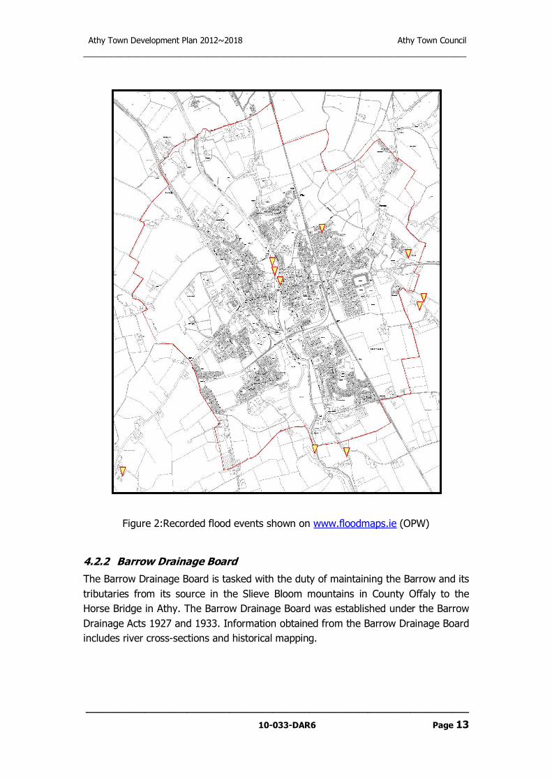
Aerial photographs were also provided by Kildare County Council of the flooding in Athy on the 23rd November 2009.
The following is noted from the Met Éireann report “Report on Rainfall of November 2009”
“Rainfall totals for November were the highest on record at most stations, including the long-term station at Valentia Observatory, where records extend back over 100 years. Valentia’s total of 360mm was its highest of any month since observations began in the area in 1866.”
“More than twice the average November amounts were measured at almost all stations, and over three times the normal amount fell in some places. Rain or showers were recorded on almost every day, with between 17 and 30 wetdays were observed (days with 1mm or more rainfall), compared with the normal range for November of between 13 and 20 wetdays. Heavy precipitation days (daily rain of 10mm or more) were also well above normal. Heaviest daily falls at most stations were recorded on the 1st, in the period 16th to 19th, and on the 29th in the east; two-day falls of over 100mm were recorded in parts of the west and southwest on the 18th/19th.”
The Met Éireann report also shows a 16 day total depth of rainfall at Athy of 166mm and a 25 day total rainfall of 209mm. These correspond to rainfall return periods of 200 and 278 years respectively.
The Ordnance Survey of Ireland provide both up-to-date and historical mapping of Athy. This can be useful to see any changes to river channels and areas liable to flooding.
ESTIMATION OF PEAK FLOOD FLOWS
The OPW hydrometric gauge at Levitstown on the River Barrow is located approximately 7km downstream of Athy. The data from the gauge has been used for purposes of this flood risk assessment on the River Barrow.
In accordance with the methodology described in the Flood Studies Report and in “Flood Estimation following the Flood Studies Report ” by Cunnane & Lynn, the annual maxima data recorded at Levitstown hydrometric gauge was used to calculate the 1 in 100 year and 1 in 1,000 year flood flows. For information, a 1 in 100 year flood event is a flood event which has the probability of being equaled or exceeded once every 100 years. Alternatively it may be expressed as a flood event which has a 1% chance of occurring in any single year. The 1 in 1,000 year flood has a 0.1% chance of occurring in any single year. The effects of climate change were also taken into account by increasing the flood flows by 20%.
Using the methodology described above, the following are the flows which correspond to the 1 in 100 year and 1 in 1,000 year flood events respectively (inclusive of climate change):
River Barrow
1 in 100 year flood flow: Q100 = 226.0 m3/s
1 in 1,000 year flood flow: Q1,000 = 284.0 m3/s

For comparison purposes, the largest flood flow recorded on the River Barrow at Levitstown since records began was in November 2009 when a flow of 180 m3/s was registered.
For the Ballyadams and Moneen Rivers, no hydrometric data was available. Therefore, the Flood Studies Report was used and the following flood flows (inclusive of climate change) were calculated:
Ballyadams River:
1 in 100 year flood flow: Q100 = 19.18 m3/s
1 in 1,000 year flood flow: Q1,000 = 25.45 m3/s
Moneen River:
1 in 100 year flood flow: Q100 = 31.30 m3/s
1 in 1,000 year flood flow: Q1,000 = 41.52 m3/s
HYDROLOGICAL MODELS OF THE RIVER
In order to assess the impact of these peak flood flows on the subject areas, a hydrological model which simulates the flow patterns during design flood events was developed using the RiverCAD software modelling package. RiverCAD software amalgamates the industry standard software packages HEC-RAS (US Army Corps of Engineers) and AutoCAD (Autodesk). The data input into the program consisted of the following:
• Cross-sectional data for the river channel and bridges as surveyed on site by Kilgallen & Partners staff;
• LiDAR survey of the surrounding lands as provided by Ordnance Survey of Ireland;
• Appropriate values for Manning’s “n” as determined from visual inspection of the site;
• Peak flows for the 100 year and 1,000 year flood events.
As November 2009 is credited with the largest flow of 180 m3/s on the River Barrow at Levitstown since records began and as a detailed set of aerial photographs were available from Kildare County Council, this flood was used to calibrate the model.
Using this model, floodplain maps were prepared for the 100 year and 1,000 year flood events. Drg. No.’s 033-DAR2-FL1 to FL4 show the resulting flood-lines which delineate the 100year and 100year flood plains (Flood Zones A and B respectively).

Athy Town Development Plan 2012~2018 Athy Town Council
___________________________________________________________________________________
________________________________________________________________________
10-033-DAR6 Page A-2
APPENDIX 2
RECORDS OF JUSTIFICATION TESTS WHERE LAND-USE
PROPOSALS PASSED THE TEST

JUSTIFICATION TEST
Lands zoned A(Town Centre)
Page 1 of 2
CRITERIA RESPONSE.
A
The urban settlement is targeted for
growth under the NSS, RPGs, statutory
plans as defined or under the Planning
Guidelines or Planning Directives
provisions of the Planning and
development Act 2000, as amended.
Athy is the largest town in south Kildare and the sixth largest in County Kildare. It is identified
as a Moderate Sustainable Growth town in the RPGs and as a Secondary Economic Growth
Centre in the GDA.
Arising from the RPGs and the County Development Plan 2011-2017, a growth target of
10,679 population / 1,252 units is prescribed for Athy between 2006-2017. These figures have
been extrapolated forward to cover the period of the Athy Development Plan 2012-2018
demonstrating a population increase of 10,819 and a unit target of 2,876.
B
The zoning or designation of the lands for
the particular use or development type is
required to achieve the proper planning
and sustainable development of the urban
settlement and in particular:
A key principle of the core strategy is to promote Athy town centre as a vibrant centre offering a
wide range of services and opportunities within a high quality urban environment.
Consolidation of the existing town centre, utilization of backlands and appropriate development
of brownfield sites is of primary importance.
The plan seeks to develop a compact urban form which will facilitate the efficient use and re-
use of land, as well as the efficient use of existing infrastructure.
The development of the town centre area is necessary as it discourages urban sprawl at lower
densities which consumes greenfield sites on the edge of the urban area, is expensive to
develop due to infrastructure costs and is located away from existing communities and existing
infrastructure.
C
(i) Is essential to facilitate regeneration
and / or expansion of the centre of the
urban settlement;
There are a number of areas within and close to the town centre which are considered suitable
for regeneration and expansion of the town centre functions. Opportunities exist particularly for
the Dominican Lands, Edmund Rice Square, the Abbey Site and along Leinster Street
including Emily Square. The proposed zoning is considered necessary to facilitate the future
sustainable regeneration and / or expansion of the centre of Athy.

JUSTIFICATION TEST
Lands zoned A(Town Centre)
Page 2 of 2
CRITERIA RESPONSE.
D
(ii) Comprises significant previously
developed and / or under utilized lands;
A considerable number of vacant premises, derelict buildings, backland areas, infill and
brownfield sites exist within the town centre area.
E
(iii) Is within or adjoining the core of an
established or designated urban
settlement;
The sites are located within the core area which acts as a centre for a broad range of
employment, retail, commercial, residential and transport functions.
F
(iv) Will be essential in achieving compact
and sustainable urban growth; and
Rejuvenation of the town centre and expansion is considered necessary to deliver a compact
urban environment. This will improve quality of life, reduce travel demand, optimise the use of
infrastructure and lessen negative social and environmental costs.
G
(v) There are no suitable alternative lands
for the particular use or development type,
in areas at lower risk of flooding within or
adjoining the core of the urban settlement.
Athy has developed as part of the Angle-Norman settlement in Ireland developing from a
relatively compact urban form. The location of the town centre has thus been long established
and relocation of town centre uses to the periphery of the town would not be in accordance
with the proper planning and sustainable development of the area.
H
SFRA must demonstrate that flood risk to
the development can be adequately
managed and the use or development of
the lands will not cause unacceptable
adverse impacts elsewhere.
The lands are not entirely covered by Flood Zones A & B. Access to the public road from
these lands can be achieved outside of these Flood Zones. The elevation of finished ground
floor, road and parking areas can be designed to be above the Flood Level for the 1000year
flood. Appropriate design and layout of for development proposals will allow the incorporation
of mitigation measures which will esnure that:
(i) there is no net reduction in the volume of floodplain storage contained within the lands
being developed;
(ii) existing flow paths for flood waters will not be compromised.

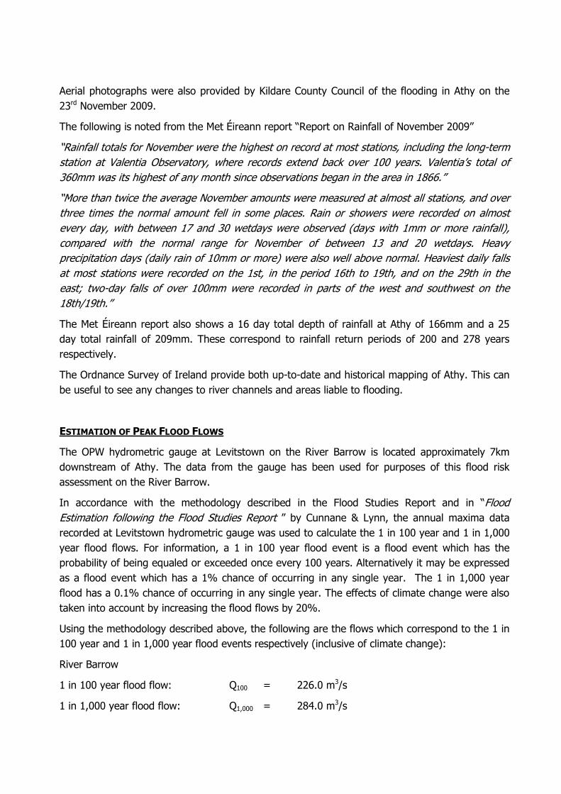
JUSTIFICATION TEST
Lands zoned E (Community & Educational) located north of the Town Centre between the Barrow and the Railway Line
Page 1 of 2
CRITERIA RESPONSE.
A The urban settlement is targeted for
growth under the NSS, RPGs, statutory
plans as defined or under the Planning
Guidelines or Planning Directives
provisions of the Planning and
development Act 2000, as amended.
Athy is the largest town in south Kildare and the sixth largest in County Kildare. It is identified
as a Moderate Sustainable Growth town in the RPGs and as a Secondary Economic Growth
Centre in the GDA.
Arising from the RPGs and the County Development Plan 2011-2017, a growth target of
10,679 population / 1,252 units is prescribed for Athy between 2006-2017. These figures have
been extrapolated forward to cover the period of the Athy Development Plan 2012-2018
demonstrating a population increase of 10,819 and a unit target of 2,876.
B The zoning or designation of the lands for
the particular use or development type is
required to achieve the proper planning
and sustainable development of the urban
settlement and in particular:
The Development Plan 2012-2018 zones approximately 33ha within the town boundary as
Community and Educational lands.
This site has:
a) a long standing established educational use located in close proximity to the town
centre area and to existing residential areas which is conducive to a sustainable and
compact pattern of urban development.
b) An established nursing home use is also located adjoining established residential
uses. The site is also largely developed.
C (i) Is essential to facilitate regeneration
and / or expansion of the centre of the
urban settlement;
The site located adjoining or in close proximity to the town centre area providing essential
services to the residents of the town centre and the wider area within the town.
The promotion and encouragement of a variety of uses, including educational and community
uses, in and around the town centre leads to the creation of the most sustainable pattern of
urban development.
In light of sustainability principles the continued use of these site are appropriate.
JUSTIFICATION TEST
Lands zoned E (Community & Educational) located north of the Town Centre between the Barrow and the Railway Line
Page 2 of 2
CRITERIA RESPONSE.
D (ii) Comprises significant previously
developed and / or under utilized lands;
The lands comprise largely developed sites. Much of the flood risk area associated with the
schools is in use as playing pitches / open space ancillary to the school.
E (iii) Is within or adjoining the core of an
established or designated urban
settlement;
The sites are located within 500m of the centre of Athy, which is characterised by commercial,
residential and town centre uses.
F (iv) Will be essential in achieving compact
and sustainable urban growth; and
Given the location of the sites in proximity to the core area and within an established residential
area, the development of this area is considered essential in achieving compact and
sustainable urban growth.
G (v) There are no suitable alternative lands
for the particular use or development type,
in areas at lower risk of flooding within or
adjoining the core of the urban settlement.
There is an established educational and nursing home use at this location. Much of the area
located within the flood risk zone associated with the educational use forms playing
pitches/open space associated with the school.
H SFRA must demonstrate that flood risk to
the development can be adequately
managed and the use or development of
the lands will not cause unacceptable
adverse impacts elsewhere.
The lands are not entirely covered by Flood Zones A & B. Access to the public road from
these lands can be achieved outside of these Flood Zones. The elevation of finished ground
floor, road and parking areas can be designed to be above the Flood Level for the 1000year
flood. Appropriate design and layout of for development proposals will allow the incorporation
of mitigation measures which will esnure that:
(i) there is no net reduction in the volume of floodplain storage contained within the lands
being developed;
(ii) existing flow paths for flood waters will not be compromised.

JUSTIFICATION TEST
Lands zoned H (Industry & Warehousing) located off the Ballylynan Road – Site A
Page 1 of 3
CRITERIA RESPONSE.
A The urban settlement is targeted for
growth under the NSS, RPGs, statutory
plans as defined or under the Planning
Guidelines or Planning Directives
provisions of the Planning and
development Act 2000, as amended.
Athy is the largest town in south Kildare and the sixth largest in County Kildare. It is identified
as a Moderate Sustainable Growth town in the RPGs and as a Secondary Economic Growth
Centre in the GDA.
Arising from the RPGs and the County Development Plan 2011-2017, a growth target of
10,679 population / 1,252 units is prescribed for Athy between 2006-2017. These figures have
been extrapolated forward to cover the period of the Athy Development Plan 2012-2018
demonstrating a population increase of 10,819 and a unit target of 2,876.
B The zoning or designation of the lands for
the particular use or development type is
required to achieve the proper planning
and sustainable development of the urban
settlement and in particular:
The Development Plan 2012-2018 targets 819 additional jobs over the period of the
development plan.
The plan assumes that if greenfield sites are developed at a modest plot ratio of 0.4 and all
lands are developed for low-medium density type employment (40m2 per employee), the
provision of the required new jobs would require the provision of 8.2 hectares of zoned land.
Currently approximately 57 hectares of undeveloped land is zoned for employment purposes in
Athy.
C (i) Is essential to facilitate regeneration
and / or expansion of the centre of the
urban settlement;
Approximately 1.4ha of the overall site comprises largely developed areas with a number of
premises operating from this portion of the overall site. A number of structures appear to be
underutilized and regeneration of this portion of the site is essential to facilitate the proper
planning and sustainable development of Athy.
The remainder of the site comprises approximately 2.5 ha and appears to be in agricultural
use. The proposed zoning on agricultural lands where sufficient lands have been zoned for
employment purposes is not considered necessary to facilitate regeneration and / or expansion
of the centre of the urban settlement.

JUSTIFICATION TEST
Lands zoned H (Industry & Warehousing) located off the Ballylynan Road – Site A
Page 2 of 3
CRITERIA RESPONSE.
D (ii) Comprises significant previously
developed and / or under utilized lands;
The lands comprise 1.4ha of previously developed lands with a number of businesses
operating from the site. Some of the existing structures appear to be under utilized.
The remainder of the overall site approximately 2.5ha appears to be in use for agricultural
purposes.
E (iii) Is within or adjoining the core of an
established or designated urban
settlement;
The site is not located within or adjoining the core town area. It is located in an area which is
largely developed along the road frontage with industrial development on the site and
residential properties west and east. Undeveloped lands bound the existing developed area to
the north.
F (iv) Will be essential in achieving compact
and sustainable urban growth; and
Given the established business on 1.4ha of the site it is considered that the continued
operation of the existing established businesses and redevelopment of the existing site is
desirable in achieving sustainable urban growth.
The development of 2.5ha of land currently in agricultural use area given its location on the
edge of the settlement and the significant flood risk associated with the land is not considered
essential in achieving compact and sustainable urban growth.
G (v) There are no suitable alternative lands
for the particular use or development type,
in areas at lower risk of flooding within or
adjoining the core of the urban settlement.
Sufficient lands are zoned for employment purposes, however given the established
employment uses on site and the largely developed nature of 1.4ha of the landholding it is
deemed appropriate to zone this portion of the subject lands for Industrial and Warehousing
uses subject to appropriate mitigation measures as identified in the Flood Risk Assessment.
Further zoning of lands located within the flood zones is not recommended for the following
reasons:
- site is significantly affected by flooding
- location on the edge of the settlement
- sufficient zoned lands in areas at lower risk of flooding are available throughout the
town

JUSTIFICATION TEST
Lands zoned H (Industry & Warehousing) located off the Ballylynan Road – Site A
Page 3 of 3
CRITERIA RESPONSE.
H SFRA must demonstrate that flood risk to
the development can be adequately
managed and the use or development of
the lands will not cause unacceptable
adverse impacts elsewhere.
The SFRA recommends that the part of the subject lands which have failed the Justification
Test be reclassified for water compatible development only in accordance with the Flood Risk
Management Guidelines.
In regard to the part of the subject lands which have passed the Justification Test, the SFRA
recommends that development of these lands be accompanied by a Site Specific Flood Risk
Assessment appropriate to the nature and scale of development being proposed. Such
Development Proposals shall also:
(i) Indicate and quantify loss of floodplain storage arising from the development proposal;
(ii) Provide compensatory storage located within or adjacent to the proposed development;
(iii) Indicate measures to ensure that water-vulnerable elements of the Development would not
be flooded during the 1000year flood;
(iv)Ensure that existing flow paths for flood waters will not be compromised.

JUSTIFICATION TEST
Lands zoned H and H2 (Industry & Warehousing) located off the Ballylynan Road – Site B
Page 1 of 3
CRITERIA RESPONSE.
A The urban settlement is targeted for
growth under the NSS, RPGs, statutory
plans as defined or under the Planning
Guidelines or Planning Directives
provisions of the Planning and
development Act 2000, as amended.
Athy is the largest town in south Kildare and the sixth largest in County Kildare. It is identified
as a Moderate Sustainable Growth town in the RPGs and as a Secondary Economic Growth
Centre in the GDA.
Arising from the RPGs and the County Development Plan 2011-2017, a growth target of
10,679 population / 1,252 units is prescribed for Athy between 2006-2017. These figures have
been extrapolated forward to cover the period of the Athy Development Plan 2012-2018
demonstrating a population increase of 10,819 and a unit target of 2,876.
In the Plan, the Council recognises the significant economic and employment challenges facing
Athy and will seek to facilitate the continuance of inward investment and the development and
revitalization of indigenous business in Athy.
It is the goal of the plan to facilitate the creation of sufficient jobs to restore the Job Ratio to at
least the 2006 figure of 55% and to increase it to match that of the County with a target Job
Ration of 62% for Athy by 2018.
The site comprises 5.9ha of land for H and 8.4 for H2.
B The zoning or designation of the lands for
the particular use or development type is
required to achieve the proper planning
and sustainable development of the urban
settlement and in particular:
A key principle of the core strategy is to promote Athy town centre as a vibrant centre offering a
wide range of services and opportunities within a high quality urban environment.
Consolidation of the existing town centre, utilization of backlands and appropriate development
of brownfield sites is of primary importance. The plan seeks to develop a compact urban form
which will facilitate the efficient use and re-use of land, as well as the efficient use of existing
infrastructure. The plan seeks the provision of 1201 no. of jobs over the period of the plan
2012-2018.
The site is located 0.6 km from the town centre and accessed from an established road
servicing an existing industrial complex. The lands subject to the H2 zoning is the subject of an
existing valid planning permission ref. 07/300059 and represent underutilised lands.

JUSTIFICATION TEST
Lands zoned H and H2 (Industry & Warehousing) located off the Ballylynan Road – Site B
Page 2 of 3
CRITERIA RESPONSE.
C (i) Is essential to facilitate regeneration
and / or expansion of the centre of the
urban settlement;
The site is located within an existing established industrial area, serviced by an existing road
and will facilitate consolidation of development in an existing industrial area around an existing
established roadway.
It is also subject to a valid planning permission on the site, and subject to appropriate
mitigation measures it is considered that potential flood risk can be adequately managed at this
location.
D (ii) Comprises significant previously
developed and / or under utilized lands;
The sites comprise underutilised lands part of which are subject to a valid permission for
industrial/retail warehousing development.
E (iii) Is within or adjoining the core of an
established or designated urban
settlement;
The site is located approx. 0.6km from the nearest proposed town centre zoning, and 1000m
from Cromaboo Bridge in an area characterized by industrial / employment uses.
F (iv) Will be essential in achieving compact
and sustainable urban growth; and
The proposed zoning is considered necessary to facilitate consolidation and expansion of one
of the main employment areas in the town, centered on an existing access road.
G (v) There are no suitable alternative lands
for the particular use or development type,
in areas at lower risk of flooding within or
adjoining the core of the urban settlement.
The site is located in close proximity to the town centre and established industrial uses. It is
also subject to a valid planning application for development. These industrial lands comprise
the most proximate lands to the town centre in Athy.
The SFRA for the town has determined that flood risk may be adequately managed through the
implementation of appropriate flood risk management measures.

JUSTIFICATION TEST
Lands zoned H and H2 (Industry & Warehousing) located off the Ballylynan Road – Site B
Page 3 of 3
CRITERIA RESPONSE.
H SFRA must demonstrate that flood risk to
the development can be adequately
managed and the use or development of
the lands will not cause unacceptable
adverse impacts elsewhere.
It is recommended that development of these lands be accompanied by a Site Specific Flood
Risk Assessment appropriate to the nature and scale of development being proposed.
Such Development Proposals shall also:
(i) Indicate and quantify loss of floodplain storage arising from the development proposal;
(ii) Provide compensatory storage located within or adjacent to the proposed development;
(iii) Indicate measures to ensure that water-vulnerable elements of the Development would not
be flooded during the 1000year flood;
(iv)Ensure that existing flow paths for flood waters will not be compromised.

Athy Town Development Plan 2012~2018 Athy Town Council
___________________________________________________________________________________
________________________________________________________________________
10-033-DAR6 Page A-3
APPENDIX 3
ADOPTED LAND-USE CLASSIFICATION MAP

I
I
I
I
I
J
C12
F
J
J
J
D
E
E
E
E
U
F
F
F
F
E
H
Q
H1
U
B
U
C26
H
E
HJ
D
E
C2
E
E
C8
A
Q
E
D
C22
E
C6
D
C21C31
C30C34
B
R
C33
H2
H
Q
H
H
H3
H3
H
H3
H3
C20
C27
C28
C11
H2
I
C13
C15
H2
D
E
E
E
E
Ordnance Survey Ireland.All rights reserved.Licence No.: 2004/07CCMA(Kildare County Council)
Note: Road, cycle and foot path locations are indicative only & may be subject to change during the detailed design process.
Athy Town Council
LEGEND:
Land Use Zoning Map
Scale: N.T.S.
Map Ref: 16.1Date: March 2012
Drawing No: 200/10/545
THIS DRAWING TO BE READ INCONJUNCTION WITH THE WRITTEN STATEMENT
Drawn By DMcN
Athy Town Development Plan2012-2018
Note: This map should be read in conjunction with the Strategic Flood Risk Assessment for Athy (Refer to Appendix II)
Improvements to existing Road Network
Athy Town Council Boundary
A: Town Centre
B: Existing Residential & Infill
C: New Residential
D: Neighbourhood Centre
E: Community & Educational
F: Open Space & Amenity
H3: Light Industrial & Commercial
H, H1, H2: Industrial & Warehousing
J: Transport & Utilities
U: Public Utilities
Public Rights of Way
500m Intervals from the centre of Town
Reservation to allow upgrading of the Rail Bridge
I: Agricultural
Rivers and Canals
New Roads Objectives
Northern Distributor Road Study Area
Q: Enterprise & Employment
1000 Year Flood Line
R: Retail / Commercial
Recommended