i
CONSULTING CIVIL & TRAFFIC ENGINEERS, RISK MANAGERS.
Project: Baldivis East District Structure Plan
Revised Transport Assessment –
REVISED FINAL – V8
Client: BEST Landowners Group
Author: Heidi Lansdell
Signature:
Date: 20th February 2015
1 ST. FLOOR, 908 ALBANY HIGHWAY, EAST VICTORIA PARK WA 6101.
PHONE +61 8 9355 1300
FACSIMILE +61 8 9355 1922
EMAIL admin@ shawmac.com.au
Consulting Civil and Traffic Engineers, Risk Managers
ii
Document Status
Version No. Author Reviewed by Date Document status
Signature Date
1 Paul Nguyen Heidi Lansdell 04/04/13 DRAFT
04/04/13
2 Paul Nguyen Heidi Lansdell 12/04/13 FINAL
12/04/13
3 Paul Nguyen Heidi Lansdell 18/06/13 REV FINAL – V3
21/06/13
4 Paul Nguyen Heidi Lansdell 01/07/13 REV FINAL – V4
01/07/13
5 Paul Nguyen Heidi Lansdell 06/09/13 REV FINAL – V5
16/09/13
6 Heidi Lansdell Tony Shaw 10/02/15 REV FINAL – V6
11/02/15
7 Heidi Lansdell Tony Shaw 12/02/15 REV FINAL – V7
12/02/15
8 Heidi Lansdell Tony Shaw 20/02/15 REV – FINAL V8
20/02/15
SHAWMAC PTY LTD
ABN 51 828 614 001
PO BOX 937
SOUTH PERTH WA 6951
T: + 61 8 9355 1300
F: + 61 8 9355 1922
© Shawmac Pty. Ltd. 2013 Z:\Jobs Active 2014\T&T Transport and Parking Studies\Baldivis East Landowners Group_Baldivis East DSP Revised Transport Assessment_1408018\RPS_Baldivis East DSP_1303007\BEST_Baldivis East DSP Rev TA_FINAL REV_V8_200215.docx
Consulting Civil and Traffic Engineers, Risk Managers
iii
CONTENTS
1. Introduction .................................................................................................................................. 1
2. Background .................................................................................................................................. 4
3. Revised Traffic Modelling and Findings ....................................................................................... 6
3.1. Existing Situation ................................................................................................................................... 6
3.2. Detailed Traffic Modelling and Future Traffic Flows ............................................................................... 8
3.2.1. Land Use and Traffic Generation .................................................................................................. 8
3.2.2. Future Traffic Flows ....................................................................................................................... 8
3.3. Key Assumptions Used in Modified Traffic Modelling .......................................................................... 10
3.4. Results of Revised Traffic Modelling .................................................................................................... 13
3.5. Public Transport Facilities .................................................................................................................... 18
3.6. Pedestrian/Cyclist Network .................................................................................................................. 19
4. Revised Conclusions .................................................................................................................. 21
5. Appendix A – Endorsed District Structure Plan .......................................................................... 23
Consulting Civil and Traffic Engineers, Risk Managers
Page 1
1. INTRODUCTION
A Revised District Structure Plan has been prepared for the Baldivis East cell and lodged with the City
of Rockingham in early 2014. The plan was considered by the Council at its Ordinary Meeting of 25th
February 2014, following the completion of the public advertising period. A modified Transport
Assessment was previously prepared by Uloth & Associates, supplemented by additional technical
assessment prepared by Move Consultants in 2012 to reflect the outcomes of detailed discussions and
negotiations with the City of Rockingham in relation to the future planning of the internal road network
and external intersection configurations, with a focus on the Baldivis Road/Mundijong Road intersection
as well as the extension of Mundijong Road west of the Kwinana Freeway. In particular, the Baldivis
Road/Mundijong Road intersection has been designed and will be constructed as a staggered offset
series of unsignalised T-intersections for the foreseeable future. A revised assessment was then
prepared by Shawmac and submitted to the City of Rockingham for review in July 2013. The July 2013
revised assessment focussed particularly on maximising opportunities to utilise east-west connections
within the part of the DSP area south of Mundijong Road to access Nairn Drive in order to accommodate
critical peak hour turning movements into the future as Nairn Drive is proposed to have greater road
capacity and operate at a higher function than Baldivis Road under future urban development within the
broader locality. Subsequent extensive consultation with the City of Rockingham resulted in feedback
being provided in the context of this modified assessment prepared by Shawmac in the context of the
transport modelling and the overall road network for the cell. The updated modelling is reflective of the
following:
Consideration of future grade separation of Baldivis Road/Wellard Road at the existing freight
railway line within the northern landholdings is required in order to establish the future ultimate
function of Baldivis Road through this area and will include the warrants associated with a
modification to this connection;
Consideration of the future function of Mundijong Road west of the Kwinana Freeway and forward
planning of the ultimate intersection configurations between the freeway and broadly the
Rockingham City Centre and coastal activity nodes. As part of the ongoing roadworks in the area,
the Baldivis/Mundijong intersection would be constructed in the first instance as a staggered
offset T-arrangement, it was likely to ultimately be configured as a grade separated node due to
clearance issues over the gas pipeline as well as significant traffic demands in an east-west
Consulting Civil and Traffic Engineers, Risk Managers
Page 2
direction. Nairn Drive would also be likely constructed as a grade separated interchange along
this section of road at the same time. These are key issues which may be considered as part of
the wider referral agency review process. The reason for this additional level of scrutiny is that
there is potential for additional delays to be introduced as this is an option which is being
considered as part of the Sub-Regional Structure Planning Process.
Review of internal local road volumes to be reflective of updated approved/constructed/planned
urban cells within the broader Baldivis Area south of Mundijong Road to the west of the DSP area
and based upon information provided by the City of Rockingham.
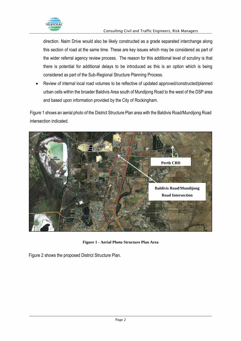
Figure 1 shows an aerial photo of the District Structure Plan area with the Baldivis Road/Mundijong Road
intersection indicated.
Figure 1 - Aerial Photo Structure Plan Area
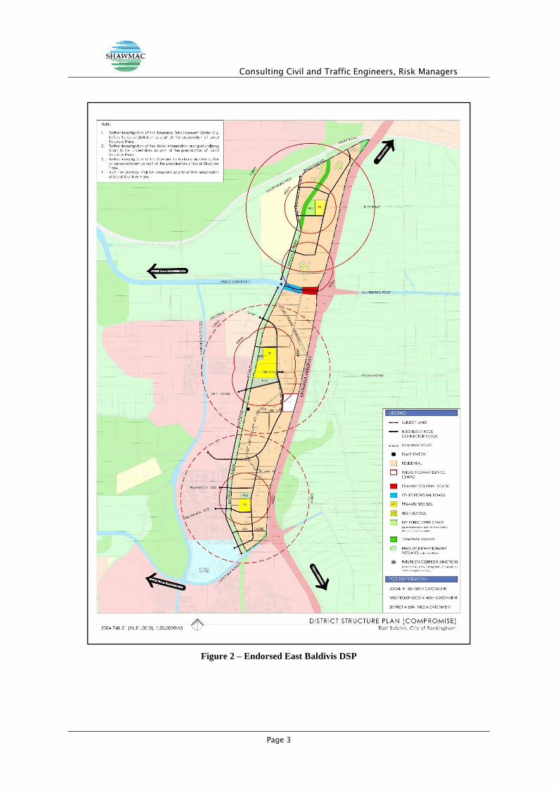
Figure 2 shows the proposed District Structure Plan.
Baldivis Road/Mundijong
Road Intersection
Perth CBD
Consulting Civil and Traffic Engineers, Risk Managers
Page 3
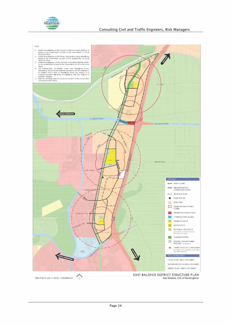
Figure 2 – Endorsed East Baldivis DSP
Consulting Civil and Traffic Engineers, Risk Managers
Page 4
2. BACKGROUND
The existing section of Baldivis Road, north of Mundijong Road has been proposed to be classified as a
District Distributor B into the future and to carry no more than 8,000 to 10,000 vpd between Mundijong
Road and Millar Road due to the staggered T-intersection configuration, which is currently proposed to
be constructed as part of the broader Mundijong Road extension roadworks in 2013 with completion in
2014.
The approved and soon-to-be-constructed modified Baldivis Road/Mundijong Road intersection,
consists of two staggered T-intersections which will connect with Mundijong Road in a right-left
arrangement with the westernmost T-intersection connecting with the north side of Mundijong Road and
the easternmost T-intersection connecting with the south side of Mundijong Road. Both intersections are
proposed to operate under full movement unsignalised control allowing for right-turns into and out of
these locations for the foreseeable future (<15 years).
One of the key issues which had been addressed as part of the initial review by the City of Rockingham
related to the ultimate configuration and associated operation of the Baldivis Road/Mundijong Road
intersection which is located within the northern half of the DSP cell. It is understood that the landowner
group (BEST) had liaised extensively with the City of Rockingham in relation to this matter, following the
submission of the original detailed Transport Assessment, prepared by Uloth & Associates in 2011, for
the Baldivis East District Structure Plan and that the City identified at that time potential queuing and
adverse traffic operations issues associated with the northbound right-turn movement during the a.m.
peak period as obstructive to constructing this intersection as a 4-way signalised intersection instead
preferring to progress a design which has now resulted in the double T-stagger priority controlled
intersection proposal. Based upon these discussions, Move Consultants updated its preliminary traffic
engineering advice (dated February 2012) and undertook the following tasks:
Review of the updated Baldivis East District Structure Plan Transport Assessment (Uloth &
Associates, November 2012);
Review of the Baldivis Road Needs Study (2005, WorleyParsons) and the subsequent draft
update released in preliminary format in February 2012;
Review of preliminary traffic operations assessment at the intersection of Baldivis
Road/Mundijong Road and Mundijong Road/Nairn Drive under a revised road network scenario,
including consideration of the interim and ultimate build-out with the DSP area and a
Consulting Civil and Traffic Engineers, Risk Managers
Page 5
threshold/sensitivity analysis associated with the triggers for potential signalisation of the
Mundijong Road/Nairn Drive intersection;
Preparation of a revised series of broader traffic modelling outputs for the DSP area and the
boundary road network in the area.
Confirmation that internal trip making (which was not accounted for in previous modelling) would
account for up to 20% of total trips associated with build-out within the DSP area;
A review of the Baldivis Road Needs Study (2005) and subsequent update indicate that previous
modelling has been based upon an assumption that Baldivis Road would provide protected direct
access to Mundijong Road (i.e. signalised or roundabout access);
Maximising permeability via the proposed internal east-west road links into the urban cell to the
west of the DSP area, in the context of practical road capacity and assumed road
classification/hierarchy;
Recognition that Nairn Drive has been designated as a higher order road within the broader
urban development area east of Mandurah Road and has been designated as a District
Distributor A with a potential daily road carrying capacity of up to 35,000 vpd;
Confirmation that the forward planning for the urban cell west of the DSP area indicates that
there is anticipated to be a significant level of mixed-use, including employment generators,
within the cell to the west, resulting in an opportunity to maximise permeability between adjacent
urban cells as well as efficient use of future road infrastructure; how much will this ‘pull’ traffic
west with a number of cells/areas already approved as part of the tertiary planning process;
Maximising opportunities to implement at least one protected connection to Mundijong Road
between Baldivis Road and the future Nairn Drive to allow for direct and safe access to Mundijong
Road via both a direct connection and grade separated full movements interchange(s) at both
Baldivis Road and Nairn Drive;
Recognition of the reduced opportunities for northbound traffic to access Mundijong Road
eastbound from the lands to the south of Mundijong Road via Baldivis Road due to the
downgrading of the intersection to an unsignalised configuration in the short-term scenario
(Option 1);
Recognition of the potential need to grade separate Baldivis Road/Wellard Road over the railway
line at the northern boundary of the DSP area and the grade separation of both Baldivis Road
and Nairn Drive at Mundijong Road (Option 2);
Consulting Civil and Traffic Engineers, Risk Managers
Page 6
Review of MRWA 2021 and 2031 modelling outputs as noted in the 2012 update to the Baldivis
Road Needs Study and that these outputs are conservative and do not account for detailed area
specific traffic movements at a more fine grained level of assessment including proposed spatial
arrangement of land uses which would be more appropriately addressed at the Local Structure
Planning and subdivision stages of urban development; and
Consideration of the ultimate function of roads internal to the DSP area in the context of proposed
activity generators such as schools and mixed-uses as well as the potential trip making
associated with these uses and practical road capacities consistent with Liveable
Neighbourhoods guidelines.
The above tasks were undertaken and addressed in the July 2013 assessment issued to the City for
consideration.
Further consultation with the City of Rockingham following endorsement of the DSP in February 2014
indicated that the additional clarification which would be required including consideration of the following
elements:
Inclusion of additional information relating to the site-specific traffic to be generated by the
endorsed DSP;
Removal of the mid-block connection to Mundijong Road between Baldivis Road and Nairn
Drive;
Modification of modelling to accommodate for the connection to Pemberton Boulevard;
Consideration of changes to urban development within the North Baldivis cell;
Clarification of the impacts of the future Stakehill Railway Station in the context of the State
Government’s Public Transport Plan for Perth 2031; and
Modification of the assessment to include updated connections to the future cycling network
external to the DSP.
3. REVISED TRAFFIC MODELLING AND FINDINGS
3.1. Existing Situation
Baldivis Road south of Millar Road has been constructed as a two-lane undivided rural road and currently
operates under an 80 kph speed limit which reduces to 70 kph north of Zig Zag Road. A section of
Baldivis Road between Pemberton Boulevard and Key Close has been upgraded to an urban standard
Consulting Civil and Traffic Engineers, Risk Managers
Page 7
District Distributor road with kerbs and street lighting and a partial service road to coincide with the
expanding residential development in the area.
Mundijong Road has been constructed as a two-lane undivided road running in the east-west direction
between Baldivis Road and Wright Road with an interchange at Kwinana Freeway. Safety Bay Road is
a four-lane dual carriageway arterial road with a two-lane roundabout intersection with Baldivis Road
and a signalised diamond interchange at Kwinana Freeway.
Kerosene Lane, Eighty Road and Fifty Road are also constructed as two-lane undivided rural roads
which extend west from Baldivis Road. Several new access roads to residential developments have also
been constructed to extend west from Baldivis Road.
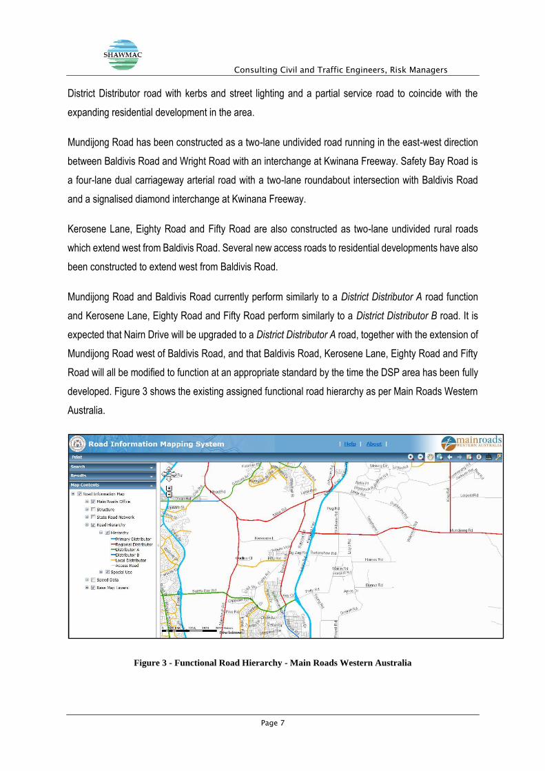
Mundijong Road and Baldivis Road currently perform similarly to a District Distributor A road function
and Kerosene Lane, Eighty Road and Fifty Road perform similarly to a District Distributor B road. It is
expected that Nairn Drive will be upgraded to a District Distributor A road, together with the extension of
Mundijong Road west of Baldivis Road, and that Baldivis Road, Kerosene Lane, Eighty Road and Fifty
Road will all be modified to function at an appropriate standard by the time the DSP area has been fully
developed. Figure 3 shows the existing assigned functional road hierarchy as per Main Roads Western
Australia.
Figure 3 - Functional Road Hierarchy - Main Roads Western Australia
Consulting Civil and Traffic Engineers, Risk Managers
Page 8
3.2. Detailed Traffic Modelling and Future Traffic Flows
3.2.1. Land Use and Traffic Generation
The projected lot yields for the District Structure Plan are proposed to be in the order of 4,200 residential
lots with approximately 1,300 lots north of Mundijong Road and approximately 2,900 lots south of
Mundijong Road as well as three Primary Schools and one Secondary School. Based upon an assumed
8 trips per dwelling, it has been estimated that the development of the DSP area could generate a in the
order of 34,000 vehicle trips per day. Review of the existing approved Local Structure Planning in the
area to the immediate west, south and north of the DSP lands indicates that the potential traffic
generated by this background traffic is expected to be in the order of 83,000 vehicle trips per day. It is
expected that the internal trips made to the Primary Schools will approximately balance the trips to the
Secondary School from locations external to the DSP area and as there are no retail, businesses or
recreational land uses proposed, it is estimated that a total of approximately 28,000 vehicular trips per
day will be added to the external road network from the DSP area assuming that internal trip making
could account for up to 20% of vehicle trips within the cell. It should be noted that endorsed planning in
the area.
3.2.2. Future Traffic Flows
The anticipated traffic generated by the primarily residential development within the endorsed DSP area
has been assigned to the surrounding road network based upon assumed traffic distribution patterns.
The traffic distribution was derived from the location of the surrounding spatial distribution of existing
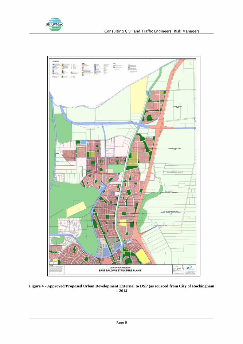
major land uses and also based upon future urban development in the area. Figure 4 illustrates a
consolidated spatial layout of the existing approved/proposed Local Structure plans and subdivisions for
the areas to the west of Baldivis Road, provided by the City of Rockingham.
Consulting Civil and Traffic Engineers, Risk Managers
Page 9
Figure 4 - Approved/Proposed Urban Development External to DSP (as sourced from City of Rockingham
– 2014
Consulting Civil and Traffic Engineers, Risk Managers
Page 10
The future traffic volumes generated by the endorsed DSP and the total future volumes (including the
existing traffic volumes generated by surrounding areas and the additional vehicular trips generated by
the DSP plus adjacent LSP’s are shown) for the surrounding road network are shown in Figure 5. This
modelling is reflective of discussions with the City and based upon feedback received in July 2014 and
further engagement with the City’s Technical Services branch, a review of existing approved/proposed
Local Structure Plans and subdivisions spatially located to the west of the DSP area (as shown in Figure
4); base existing traffic volumes, a review of existing background traffic studies and issued outlined in
correspondence issued by the City following endorsement of the DSP.
For the purposes of this assessment, only the long-term scenario (referred to as Option 2 or grade-
separation scenario in the July 2013 assessment) has been considered with both Baldivis Road and
Nairn Drive constructed as grade separated interchanges at Mundijong Road (underpasses) and a grade
separation of Baldivis Road/Wellard Road at the railway line at the northern end of the cell.
The assessment of these two options is critical with regard to circulation of the proposed District Structure
Plan to relevant referral agencies involved in the ongoing Sub-Regional Structure Planning exercise
currently being undertaken by the Department of Planning and the future alignment and function of
Baldivis Road north of Mundijong Road and the thresholds associated with the future needs to grade
separate the Baldivis Road/Wellard Road railway crossing and the potential to grade separate the
Baldivis Road/Mundijong Road and Nairn Drive/Mundijong Road intersections.
3.3. Key Assumptions Used in Modified Traffic Modelling
A subsequent preliminary review has yielded the following results:
Internal trip making within the DSP may account for up to 20% of total trips associated
with the ultimate build-out within the cell. Typically, movement will generally be destined to
and originating from major infrastructure nodes/corridors during typical weekday peak periods
(i.e. railway stations such as Wellard, Rockingham and Warnbro. It has been assumed that
internal trip making within the area north of Mundijong Road is in the order of 10% locally and
up to 10% destined to and originating from the DSP area south of Mundijong Road (i.e. Baldivis
Town Centre, school precincts, etc.). It has been assumed in terms of external trip making that
approximately 20% of the balance of trips generated by the lands to the north of Mundijong
Road will be destined to and originating from the north via Baldivis Road through to Kwinana
and other points north and the balance to and from the west (Rockingham, adjacent industrial
Consulting Civil and Traffic Engineers, Risk Managers
Page 11
areas, etc.) and to and from the east (i.e. Kwinana Freeway, etc.).
A review of the Baldivis Needs Study (2005) and subsequent update indicate that
previous modelling has been based upon an assumption that Baldivis Road would
provide protected direct access to Mundijong Road (i.e. signalised or roundabout
access). The original 2005 study was premised on a direct connection via a 4-way signalised
intersection; however, recent planning for the Mundijong Road extension indicates that the
current proposal which will be implemented in 2013 consists of a staggered T-intersection
arrangement (with Stop Control on the Baldivis Road approaches to Mundijong Road), with the
potential to downgrade the northern leg (i.e. into the Cedar Woods landholdings) to a left-in/left-
out in the future. The study was subsequently updated and issued in draft in early 2012, based
upon revised traffic modelling but still showing a 4-way signalised arrangement. The City of
Rockingham has since advised that this study is now considered to be redundant and has
referred to Move Consultant’s February 2012 advice and attached revised preliminary modelling
results as well as updated ‘2013 base case’ traffic data to guide road planning through the area
to be used as a basis from which to develop forward traffic projections for the grade-separated
option (Option 2 as outlined in Shawmac’s 2013 assessment) to form the basis of the modified
assessment documented in this report.
Maximised permeability via the proposed internal east-west road links into the urban cell
to the west of the DSP area, in the context of practical road capacity and assumed road
classification/hierarchy. Nairn Drive designated as a higher order road within the broader
urban development area east of Mandurah Road and has been designated as a District
Distributor A with a potential daily road carrying capacity of up to 35,000 vpd. The City of
Rockingham has recognised that Nairn Drive will play a critical role in relation to not only
accommodating locally generated traffic within the mixed-use precinct in which it is located but
also to provide critical north-south road capacity to accommodate east-west permeability from
adjacent cells including the Baldivis East DSP area due to constraints associated with the
Baldivis Road/Mundijong Road connections. The City has also indicated that the construction
of Mundijong Road west of the Kwinana Freeway through the DSP area will commence in early
2013 with the road opened in August 2014 and while there are no seriously entertained planning
proposals to modify the approved intersection configurations along Mundijong Road with
Baldivis Road to accommodate a grade separation or ‘flyover’ in the short-term however, any
such proposal would have to consider a long-term proposition with no current commitment made
Consulting Civil and Traffic Engineers, Risk Managers
Page 12
to planning, programming or funding of this change to the approved design and would be
reviewed in detail as part of the Sub-Regional Structure Planning process as well as the detailed
Local Structure Planning processes .
The forward planning for the urban cell west of the DSP area indicates that there is
anticipated to be a significant level of mixed-use, including employment generators,
within the cell to the west, resulting in an opportunity to maximise permeability between
adjacent urban cells as well as efficient use of future road infrastructure. Based upon
preliminary modelling, the estimated traffic to and from the west and north via Nairn Drive could
be as high as 40 to 50% of locally generated traffic. This quantum of traffic can be
accommodated within the practical capacity and functional road classification of Nairn Drive
under the long-term grade separation scenario.
Opportunities to implement at least one protected connection to Mundijong Road
between Baldivis Road and the future Nairn Drive to allow for direct and safe access to
Mundijong Road. However, it should be noted that this potential future connection lies outside
the boundaries of the DSP area and the City of Rockingham has advised that this proposed
connection is to be removed from the plans for the area and is no longer to be considered in the
context of the updated transport modelling assessment. A review of the road and network
capacity opportunities along this section of Mundijong Road indicates residual capacity within
the 20 to 25-year timeframe of 10,000 to 15,000 vpd which will allow for build-out within the
endorsed DSP plus the adjacent approved LSP’s and the resultant traffic generated by these
areas to be accommodated within this residual capacity.
Recognition of the reduced opportunities for northbound traffic to access Mundijong
Road eastbound from the lands to the south of Mundijong Road via Baldivis Road due to
the downgrading of the intersection to an unsignalised configuration. This has been
addressed above in relation to the higher order road classification and excess practical capacity
of Nairn Drive and was been considered as part of the development of future traffic modelling
for Option 1 documented in the July 2013 assessment.
Review of MRWA 2021 and 2031 modelling outputs as noted in the draft update to the
Baldivis Road Needs Study and that these outputs are conservative and do not account
for detailed area specific traffic movements at a more fine grained level of assessment
including proposed spatial arrangement of land uses. This model should be considered only
to be used as a ‘coarsely grained’ traffic operations model. The City of Rockingham concurs that
Consulting Civil and Traffic Engineers, Risk Managers
Page 13
more detailed modelling is required, particularly in the context of Local Structure Planning in the
area and to forward plan long-term road connections, including the potential to modify the
proposed staggered T-arrangement of Baldivis Road at Mundijong Road to a grade separated
partial diamond interchange and that a potential extension of Nairn Drive north of Mundijong
Road should be further explored in the context of the sub-regional structure planning exercise
currently being undertaken by the Department of Planning. However, it should be noted that the
City has also indicated that the construction of Mundijong Road west of the Kwinana Freeway
will proceed as planned with the staggered T-intersection unlikely to be modified within the short-
to medium-term (5 to 15 years hence).
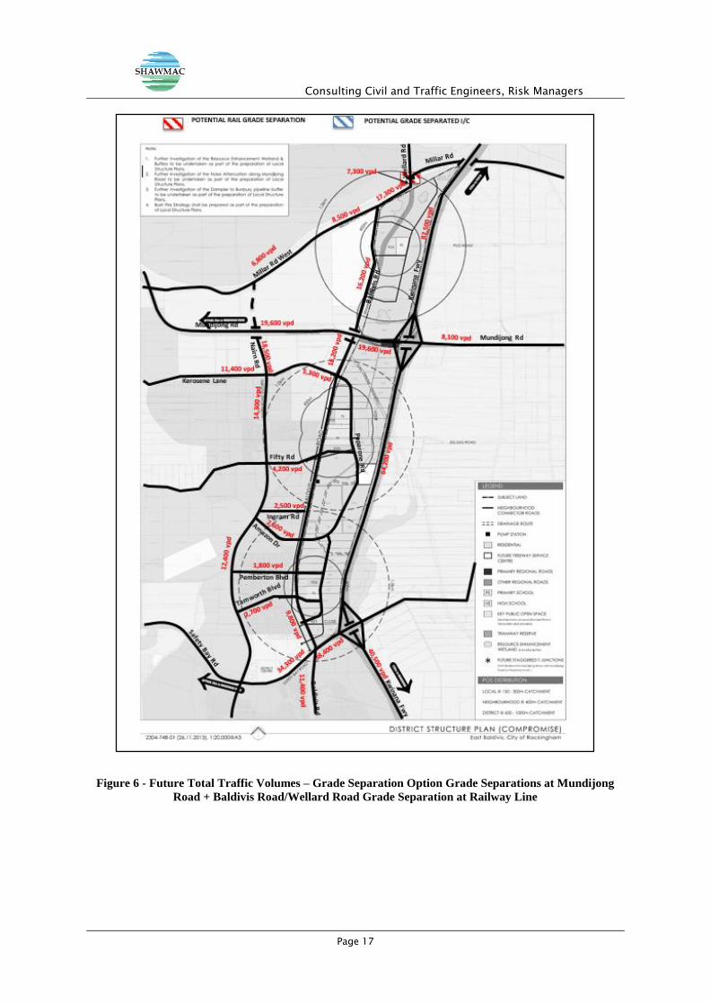
3.4. Results of Revised Traffic Modelling
The results of revised traffic modelling for the DSP cell are shown in Based upon the assumptions as
noted above, the results of the revised updated traffic modelling assessment undertaken for the DSP
area based upon the potential long-term changes to the primary boundary road network as well as
consideration of permeability options to lands located to the west of the cell with a focus on maximising
opportunities to access the higher order road network reflect the following:
Internal trip making (which was not accounted for in previous modelling) may account for up to
20% of total trips associated with build-out within the DSP area which takes into consideration
non-residential generated traffic associated with proposed schools in the area;
Nairn Drive has been designated as a higher order road within the broader urban development
area east of Mandurah Road and as a District Distributor A road with a potential daily road
carrying capacity of up to 35,000 vpd. This practical capacity and functional road classification
has been assumed as constant the road network scenario assessed in this updated report;
The forward planning for the urban cell west of the DSP area indicates that there is anticipated
to be a significant level of mixed-use, including employment generators, within the cell to the
west, resulting in an opportunity to maximise permeability between adjacent urban cells as well
as efficient use of future road infrastructure under both scenarios;
Opportunities to implement at least one protected connection to Mundijong Road between
Baldivis Road and the future Nairn Drive to allow for direct and safe access to Mundijong Road
has been removed in the updated modelling outputs;
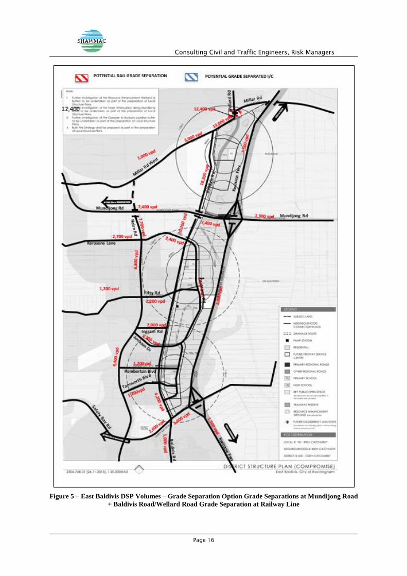
The revised road network incorporating the potential grade separation of Baldivis Road and
Consulting Civil and Traffic Engineers, Risk Managers
Page 14
Nairn Drive at Mundijong Road to allow for full protected movements via a grade separation
indicates that land will be required within the north-east quadrant of the Baldivis Road/Mundijong
Road intersection to allow for a grade separation. Traffic volumes on Baldivis Road under this
option as shown in the attached figure with resultant increases expected to increase by 50%
along the section south of Mundijong Road. As a result, the functional road classification of
Baldivis Road north of Mundijong Road to Millar Road is likely to be of a District Distributor A
road with the section south of Mundijong Road maintained as a District Distributor B road.
A review of the potential need to grade separate Baldivis Road/Wellard Road at the existing
railway line north of Millar Road will need to be addressed during the Local Structure Planning
stages of the planning process. A review of the potential ‘spillover’ effect and ‘worst case
scenario’ of the full protected grade separation of Baldivis Road at Mundijong Road is likely to
result in a warrant being met for grade separation of Baldivis Road/Wellard Road at the existing
freight railway located along the northern boundary of the DSP based upon a review of MRWA
exposure index warrant;
A number of critical higher order road planning issues such as the potential connections to and
from future industrial development to the east of the freeway north of Mundijong Road, to and
from the Rockingham City Centre via Mundijong Road and the potential closure of Millar Road
have yet to be resolved and will be addressed as part of the overall tertiary planning for the area;
The proposed internal road network and external road network connections associated with the
District Structure Plan are consistent with the aims of the current planning being progressed as
part of the preparation of the South-West Corridor Regional Structure Plan being undertaken by
the Department of Planning as well as standard traffic engineering principles;
The future functions of both Amazon Drive, Pemberton Boulevard and Ingram Road are
consistent with approved and proposed Local Structure Planning area for the area;
Maximising the efficient and effective use of the future Nairn Drive to be consistent with a District
Distributor A classification and with sound traffic planning principles under the ‘worst case’
scenario has yielded consistent modelling results in comparison to previous assessments;
The downgrading the future Baldivis Road between Safety Bay Road and Mundijong Road to a
District Distributor B will still allow for effective and efficient connectivity to the primary boundary
road network through maximising the use of higher order roads and recognition of long-term
travel patterns within the broader urban area, including access to the Kwinana Freeway at
Consulting Civil and Traffic Engineers, Risk Managers
Page 15
Mundijong Road and Safety Bay Road under both Options 1 and 2; and
Recognition of the constraints associated with providing additional connection to Mundijong
Road between Baldivis Road and the Kwinana Freeway by identifying the opportunity for an
additional connection to Mundijong Road between Baldivis Road and Nairn Drive was
addressed in the July 2013 assessment. The City has concluded that this interim connection is
will not be implemented with ‘worst case scenario’ and as a consequence, it has been removed
as part of the updated assessment specific to the endorsed DSP. Modifications to the higher
order boundary road network external to the endorsed DSP will be addressed in more detailed
during the Sub-Regional Structure Planning Process, indicating that the combined impact of full
grade separating Baldivis Road and Nairn Drive at Mundijong Road to provide for full protected
access and the effective elimination of an interim direct connection will result in significant
increases in traffic volumes both to the north and south of Mundijong Road with an expected
100% increase in traffic volumes north of Mundijong Road and 50% increase south of Mundijong
Road. This would likely result in a requirement to consider a grade separation of Baldivis
Road/Wellard Road at the existing freight railway line along the northern boundary of the cell.
The details associated with this change to the road network would require detailed nodal
assessment during the Local Structure Planning process.
The traffic volumes have been based upon full ‘build-out’ in adjacent areas, including the North
Baldivis area, and have taken into consideration the fact that the Stakehill Railway Station is
unlikely to be delivered in the short- to medium-term. As a consequence, the modelling is
reflective of a revised distribution pattern associated with the attraction of the Wellard, Warnbro
and Rockingham Railway Station with the ‘worst case’ scenario of a 10% public transport modal
split assumed.
Consulting Civil and Traffic Engineers, Risk Managers
Page 16
Figure 5 – East Baldivis DSP Volumes – Grade Separation Option Grade Separations at Mundijong Road
+ Baldivis Road/Wellard Road Grade Separation at Railway Line
Consulting Civil and Traffic Engineers, Risk Managers
Page 17
Figure 6 - Future Total Traffic Volumes – Grade Separation Option Grade Separations at Mundijong
Road + Baldivis Road/Wellard Road Grade Separation at Railway Line
Consulting Civil and Traffic Engineers, Risk Managers
Page 18
3.5. Public Transport Facilities
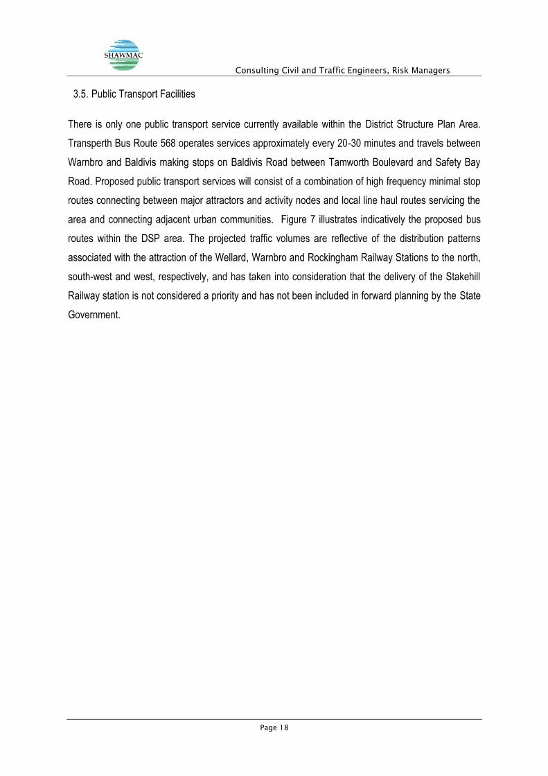
There is only one public transport service currently available within the District Structure Plan Area.
Transperth Bus Route 568 operates services approximately every 20-30 minutes and travels between
Warnbro and Baldivis making stops on Baldivis Road between Tamworth Boulevard and Safety Bay
Road. Proposed public transport services will consist of a combination of high frequency minimal stop
routes connecting between major attractors and activity nodes and local line haul routes servicing the
area and connecting adjacent urban communities. Figure 7 illustrates indicatively the proposed bus
routes within the DSP area. The projected traffic volumes are reflective of the distribution patterns
associated with the attraction of the Wellard, Warnbro and Rockingham Railway Stations to the north,
south-west and west, respectively, and has taken into consideration that the delivery of the Stakehill
Railway station is not considered a priority and has not been included in forward planning by the State
Government.
Consulting Civil and Traffic Engineers, Risk Managers
Page 19
Figure 7 – Proposed Future Transperth Bus Services
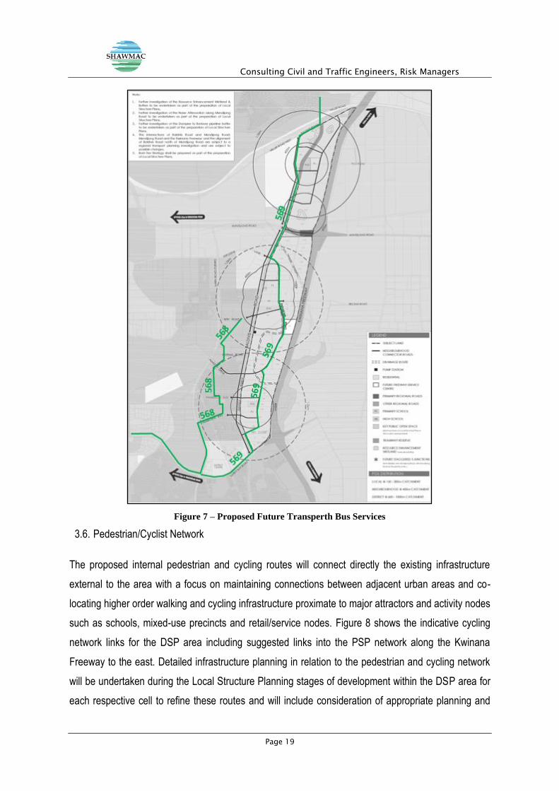
3.6. Pedestrian/Cyclist Network
The proposed internal pedestrian and cycling routes will connect directly the existing infrastructure
external to the area with a focus on maintaining connections between adjacent urban areas and co-
locating higher order walking and cycling infrastructure proximate to major attractors and activity nodes
such as schools, mixed-use precincts and retail/service nodes. Figure 8 shows the indicative cycling
network links for the DSP area including suggested links into the PSP network along the Kwinana
Freeway to the east. Detailed infrastructure planning in relation to the pedestrian and cycling network
will be undertaken during the Local Structure Planning stages of development within the DSP area for
each respective cell to refine these routes and will include consideration of appropriate planning and
Consulting Civil and Traffic Engineers, Risk Managers
Page 20
delivery of the shared path/Principal Shared Path network within the DSP to connect with existing and
planned future infrastructure along the Kwinana Freeway and adjacent to the local schools and
neighbourhood centres.
Figure 8 – Proposed Bicycle Network (Inclusive of the Extension of the Principal Shared Path Network)

Consulting Civil and Traffic Engineers, Risk Managers
Page 21
4. REVISED CONCLUSIONS
The results of the revised traffic modelling for the Baldivis East District Structure Plan area indicates that
the proposed internal road network within the DSP area is appropriate and can accommodate the level
of anticipated daily and peak hour within and external to the area and the approved and planned external
boundary road network can accommodate the area-generated traffic.
Details relating to the specific nodal traffic operations along Mundijong Road will be addressed during
the Local Structure Planning stages of urban development; however, a review of opportunities to provide
an additional connection to Mundijong Road between Baldivis Road and Nairn Drive indicates that there
is residual capacity of between 10,000 and 15,000 vpd to accommodate demand along this section of
road and at this potential location, based upon the modelling assumptions noted as part of the modelling
for the revised infrastructure scenario. Generally, the results of the traffic modelling undertaken for the
endorsed DSP are generally consistent with previous modelling engagements undertaken in 2012 and
2013 and the projected internal daily traffic volumes for the local road network are consistent with the
proposed functional road classifications and background traffic studies. The ‘worst case’ scenario option
which considers the confluence of the fully protected grade separation of both Baldivis Road and Nairn
Drive at Mundijong Road with the elimination of an at-grade fully protected interim connection at
Mundijong Road, the resulting traffic projections indicate that expected daily volumes on Baldivis Road
will increase by approximately 50% south of Mundijong Road and 100% north of Mundijong Road. This
could potentially result in an upgrading of the road classification assigned to Baldivis Road under Option
1 as a District Distributor B to a District Distributor A along this section of road as well as potentially
triggering a grade separation of Baldivis Road/Wellard Road at the existing freight railway line along the
northern boundary of the DSP area. However, it should also be noted that there is reasonable scope for
the Department of Planning, in conjunction with the City of Rockingham, to consider expanding the range
of traffic modelling and transport/road options through the area as part of the ongoing South-West
Corridor Sub-Regional Structure Planning process with the details relating to specific nodal operations,
including grade separation of intersections along Mundijong Road and of the Baldivis Road/Wellard
Road/freight railway node being addressed during the Local Structure Planning stages of urban
development. Based upon discussions with Main Roads WA, the Department of Planning and the City
of Rockingham, it is concluded that that detailed modelling, including detailed nodal assessment (i.e.
intersection operations assessment as well as consideration of grade separation thresholds) and a more
detailed level of technical rigour is appropriate to be undertaken, prior to the finalisation of the Sub-
Consulting Civil and Traffic Engineers, Risk Managers
Page 22
Regional Structure Planning process, in consultation with relevant State and Local Government
agencies and Local Structure Planning for individual cells and in detailed consultation with affected
landowners.
In conclusion, the results of the revised modelling for the endorsed DSP indicate that the proposed road
network internal to the area is appropriate and can accommodate the projected traffic demands
associated with development within the cell.
Consulting Civil and Traffic Engineers, Risk Managers
Page 23
5. APPENDIX A – ENDORSED DISTRICT STRUCTURE PLAN
Consulting Civil and Traffic Engineers, Risk Managers
Page 24
Recommended