54 STC/MS™ CATA S T R O P H I C EV E N T S
INTRODUCTIONWhat causes the wind to blow? Mostly, it has todo with the uneven heating of the earth. Breezesoccur because land and water heat and cool atdifferent rates.
When the sun’s energy heats the earth, thetemperature of the air above the earth’s surfacechanges. Air, warmed by the surface below it,starts to rise, and cool air moves in to take itsplace. This circulation of air causes changes inthe weather, including the formation of winds.
In this lesson, you will connect two of theConvection Tubes you used in Lesson 4. Whathappens when two masses of air with the sametemperature and humidity meet? What happenswhen air masses of different temperature andhumidity conditions meet? After observing themovement of air in the convection model youset up, you will apply what you have learned totwo real-world situations. You will analyze howland breezes and sea breezes form and how tor-nadoes develop in the United States.
5Convection Currents in the Air
LESSON
OBJECTIVES FOR THIS LESSON
Set up an investigation thatdemonstrates what happens to two air masses when they meet.
Analyze the movement of two air masseswith different temperature and humidityconditions.
Devise working definitions for the terms“convection current” and “weather front.”
Relate the movement of air within theconvection model to the formation of landand sea breezes and the development oftornadoes.
Explain how winds form.
Hold on to your hat! Whether you are walking along a
beach or flying a kite in an open field, a really windy
day can make you feel like you are about to be swept
off your feet. Breezes occur because of the different
rates at which land and water heat and cool.
© C
ATH
ERIN
E K
ARN
OW
/WO
OD
FIN
CAM
P &
AS
SO
CIA
TES

STC/MS™ CATA S T R O P H I C EV E N T S 55
Getting Started
1. Think back to Lesson 4. What did you dis-cover about how the temperature of airaffects the way air moves? Discuss thiswith your class.
2. Look back to the reading selection, “AirMasses,” on page 49 in Lesson 4. Wheredo you think air masses with differenttemperature and humidity conditions aremost likely to meet in the United States?
MATERIALS FOR LESSON 5
For you1 copy of Student
Sheet 5.1a: WhenAir Masses Meet
1 copy of StudentSheet 5.1b:Convection on theEarth
For your group 1 tote tray2 Convection Tubes 1 piece of plastic
tubing1 flashlight1 120-mL plastic
container of hotwater (with screw-top lid)
1 120-mL plasticcontainer ofcrushed ice (withscrew-top lid)
1 candle1 punk stick 1 small aluminum
panScissors

Inquiry 5.1Investigating the Effects ofColliding Air Masses
PROCEDURE
1. Collect one copy of Student Sheet 5.1a:When Air Masses Meet. Read the ques-tion at the top of the student sheet:What happens when two of the same—and then different—air masses meet?You will investigate this question duringthe inquiry.
2. Look at one set ofconnectedConvection Tubesand the materialsfor each group.Then look at Table1 on Student Sheet5.1a. What aresome ways youmight set up thisequipment to inves-tigate the questionin this inquiry?Discuss this withyour class. One sug-gested setup isshown in Figure5.1.
3. On your studentsheet, make a list ofthe materials youwill use and theprocedures you willfollow to test eachsetup. Be preparedto share your ideaswith the class.
56 STC/MS™ CATA S T R O P H I C EV E N T S
LESSON 5 CO N V E C T I O N CU R R E N T S I N T H E AI R
Figure 5.1 Connected Convection Tubes
4. What will you keep the same in eachsetup? What will you change during eachtest? Write down your ideas on StudentSheet 5.1a.
5. What do you think will happen whencold, moist air meets cold, moist air?What do you think will happen whenwarm moist air meets warm moist air?What will happen when cold moist airmeets hot dry air? Discuss your predic-tions with your group. Record what youthink will happen in the Predictions col-umn in Table 1 on your student sheet.
Candle Crushed ice

STC/MS™ CATA S T R O P H I C EV E N T S 57
LESSON 5 CO N V E C T I O N CU R R E N T S I N T H E AI R
6. Review with your teacher the followingpoints, which you should keep in mindwhile you work:
A. Keep the Convection Tubes connected atall times.
B. Do not record any temperature changesin this lesson.
C. Introduce smoke into the top of the cylin-der, as shown in Figure 5.2.
7. Before you begin, review Safety Tips withyour teacher.
8. Collect and set up your materials. Beginthe investigation. Discuss your observa-tions with your group as you work, andrecord them on your student sheet. Foreach setup, remember the proceduresyour group developed. Use your flashlightto see the smoke.
9. When you have finished testingall three conditions, clean up.Put out the burning punk bydipping just the tip of it in acup of water. Cut off thewet tip with the scissors.Refill your containerwith crushed ice forthe next class.
SAFETY TIPS
Roll up loosesleeves and tuckin loose clothing.Tie back longhair.
Do not let theburning punktouch the cylin-der. The plasticcylinder will meltif it does.
Do not ask yourteacher to lightyour candle untilyou are ready.
Do not reachacross an openflame.
Do not leave thecandle under theplastic cylinderfor longer than 1minute. The plas-tic will get hot.
Figure 5.2 Use the punk stick to introduce smoke
into the top of the tube.
58 STC/MS™ CATA S T R O P H I C EV E N T S
LESSON 5 CO N V E C T I O N CU R R E N T S I N T H E AI R
5. Your teacher will ask you to completeStudent Sheet 5.1b: Convection on theEarth to find out what you know abouthow air moves. On this sheet you will dothese steps:
• Illustrate how air moved in your group’sConvection Tube.
• Relate the movement of air within yourconvection model to the formation ofland and sea breezes.
• Apply the movement of air within yourconvection model to the development oftornadoes.
REFLECTING ON WHAT YOU'VE DONE
1. Answer the following questions. Discussyour observations with the class.
A. What did you observe when both tubescontained air with the same temperatureand humidity conditions? Why do youthink this happened?
B. What did you observe when the tubescontained air with different temperatureand humidity conditions? Why do youthink this happened?
C. On the basis of your results fromLessons 4 and 5, under what conditionsdo you think winds and rotating stormsmight form?
2. Look again at the illustration in “AirMasses” (Lesson 4). Where in the UnitedStates do you think air masses with differ-ent temperature and humidity conditionsmight meet? The boundary that formswhen this happens is called a weatherfront. What type of weather do you thinkmight occur along a front?
3. A convection current formed when youset up the Convection Tubes so that a hotair mass collided with a cold one. Useyour experiences to write your own defin-itions for the terms “convection current”and “weather front.” Discuss your defini-tions with the class.
4. Read “Why Does the Wind Blow?” onpages 59–62 and “Weather Fronts” onpage 63. Revise your definitions if needed.

STC/MS™ CATA S T R O P H I C EV E N T S 59
LESSON 5 CO N V E C T I O N CU R R E N T S I N T H E AI R
What causes the wind to blow?From light breezes to strong gusts,winds are the result of unevenheating of the earth’s surfaces.
The process begins as the sunwarms the earth. As the layer ofair above a warmed surface heats,it expands, becomes lighter, andrises. Meteorologists use the word“convection” to describe themovement of heat through air or water. Thismovement results from temperature differences.As the warm air rises, it expands and cools. Coldair moves in to replace the rising warm air. Theearth warms this layer of incoming cool air andit, too, rises, and then is replaced by anotherlayer of cooler air. This cycle goes on and on.The circulating flow of air resulting from temper-ature differences is called a convection current.Convection currents can form in liquids, too.
Land Breezes and Sea BreezesLand breezes and sea breezes are caused byconvection. These breezes occur where largebodies of land and water meet. The differentrates at which land and water heat and cool
Why Does theWind Blow?
cause these winds. This happens more often inearly summer than at other times of the year.
During the day, land warms up faster than thewater in lakes or oceans does. Warm air risesabove the land, forming an area of low pressure.In low-pressure areas, the air is warm and light,which means it is not dense. Cool air over thewater moves toward the land and replaces therising warmed air. This flow of air is called a seabreeze.
At night, the land cools faster than the waterdoes, so the air over the land becomes coolerthan the air over the water. As the warm airover the water rises, cool air from the landmoves toward the water to replace it. The flowof air from land to water is called a land breeze.
Uneven heating causes winds.
Sea breezes occur during the day. Land breezes occur at night.
Warm air
Upper winds
Surface winds
Snow
Cool air
Soil
SEA BREEZE
Cool water Warm land
LAND BREEZE
Warm water Cool land

60 STC/MS™ CATA S T R O P H I C EV E N T S
LESSON 5 CO N V E C T I O N CU R R E N T S I N T H E AI R
tropics, very warm. Near the poles, sunlight thatreaches the earth's surface has to pass throughmore atmosphere than at the equator. Becausethe atmosphere both absorbs and reflects thesun’s heat, the poles are not as warm.
Other factors can cause local winds. One fac-tor is color. You may already know, for example,that dark-colored clothing absorbs heat fasterthan light-colored clothing does. This happenson the earth, too. Dark soils absorb heat fasterthan light-green fields do.The air above these surfacesis warmed or cooled accord-ingly, and local winds result.
Global WindsWinds don't just blow locally.They are continually formingaround the earth, moving ina particular direction andtraveling over long distances.These winds, which formbetween the equator and thepoles, are called globalwinds.
The equator and the polesare not heated evenly. Nearthe equator, the sun’s raysare more intense. (See theillustration.) This makes theareas nearby, called the
What Are Monsoons?Monsoons are very powerful land and seabreezes that change direction with theseasons. They occur mostly in southernAsia and are an important part of dailylife there.
During the summer, the air over theland heats up. As the hot air rises, it isreplaced by warm, moist air from theIndian Ocean. The water vapor in therising air condenses, forms clouds, andproduces rain. The heat in the areahelps drive the monsoons, bringing longperiods of rain to the region. During thesummer, people grow rice and othercrops that need much moisture.
In the winter, the land cools faster than thewater does. Cool air over the land sinks andmoves out to sea. During this time of year,southern Asia receives little rain.
Sunlight passes through more atmosphere near the poles.
© S
. N
OO
RAN
I/W
OO
DFI
N C
AMP
& A
SS
OC
IATE
S
Cycle rickshaws on the streets of Bangladesh during the
monsoon season
Sun’s rays

the sun’s energy. Trade winds flowtoward the equator, turning west
as they go. Westerlies flow fromwest to east. These winds arecalled westerlies because theyflow from the west. For exam-ple, polar westerlies arewinds that flow toward thepoles, turning east as they go.Easterlies flow from east towest. These winds are called
easterlies because they flowfrom the east. For example,
polar easterlies are winds thatsink at the poles, spread outward,
and turn west as they go. What happens when these global
winds meet? Where the westerlies andeasterlies meet, weather changes occur. The
meeting of the westerlies and easterlies has amajor effect on the weather that occurs inNorth America.
STC/MS™ CATA S T R O P H I C EV E N T S 61
LESSON 5 CO N V E C T I O N CU R R E N T S I N T H E AI R
Circling the Globe Global winds are the result of giantconvection currents that circulatewithin the Northern and South-ern Hemispheres of the earth.As warm air is heated at theequator, it rises and flows bothnorth and south toward thepoles. If the earth didn’t rotate,the hot air at the equatorwould rise to the poles, cool,sink, and flow back to the equa-tor again. (See the illustration,right.) But the earth does rotate,which means that air and water cur-rents on the earth are deflected.
Trade winds, westerlies, and easterliesare names of different kinds of global windsthat form because of the earth’s rotation and
The earth's rotation and other factors cause convection
currents to form on the earth. Winds in the Northern and
Southern Hemispheres are mirror images of each other.
If the earth did not rotate and if its surface were
flat and uniform, air would form perfect convec-
tion currents. Hot air would rise at the equator,
move all the way to the poles, and then sink.
Surfacewinds
Warmairrises
Cold air sinks
Warmairrises
Convectioncurrent
Cold air sinks
Easterlies
Westerlies
Tradewinds
Convectioncurrents
62 STC/MS™ CATA S T R O P H I C EV E N T S
LESSON 5 CO N V E C T I O N CU R R E N T S I N T H E AI R
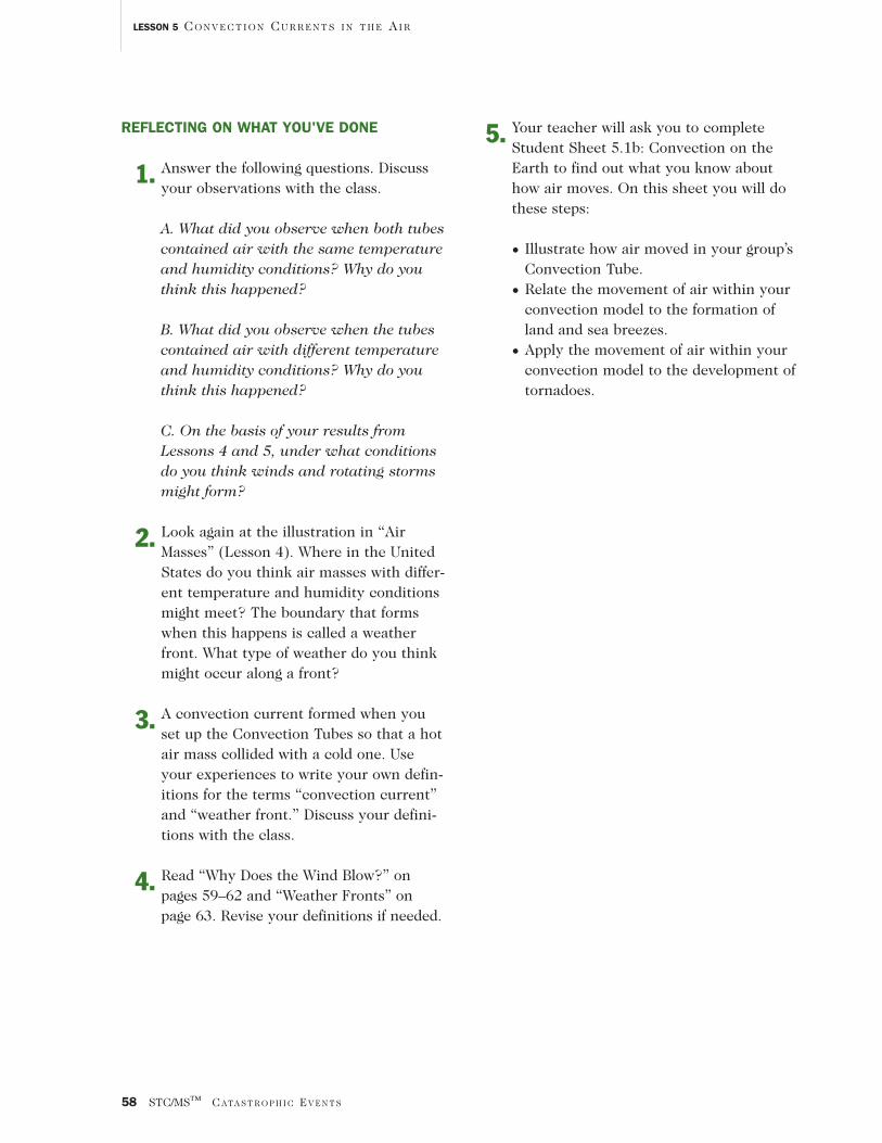
Jet StreamStrong winds inwhat is called ajet stream arelong, relativelynarrow “tubes” ofair in the uppertroposphere.Located about 10km above theground, the jetstreams are onlya few hundredkilometers wide,but they some-times stretchhalfway aroundthe earth.
Jet streamwinds usuallytravel at about200 kilometers per hour, but sometimes theycan move twice that fast. American pilots dur-ing World War II discovered them. Jet streamsand their paths vary from day to day and sea-son to season. These powerful winds play a
large part in moving air masses around theearth. This means that they also play a big partin determining the earth’s weather. Forecasterscan use the path of a jet stream to predict howweather will move across the country. �
©:
1999 A
CC
UW
EATH
ER,
INC
./AC
CU
WEA
THER
.CO
M
The jet stream affects
where fronts form,
and it moves weather
in the United States
from west to east.
NAS
A
Clouds in the jet stream over the Middle East. Today, the jet streams help high-flying airplanes
travel east. Planes going west try to avoid the jet stream. Can you figure out why?
STC/MS™ CATA S T R O P H I C EV E N T S 63
LESSON 5 CO N V E C T I O N CU R R E N T S I N T H E AI R
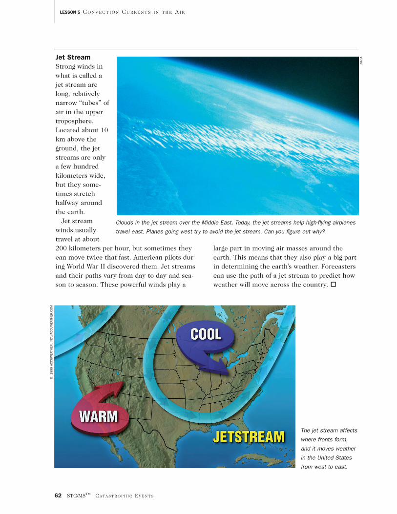
the point where the warm air and cold air meet,water vapor in the warm air condenses intorain, snow, fog, or clouds. If the stationary frontremains in place for a long time, it may bringdays of clouds and precipitation.
In a more complex frontal system—anoccluded front—both a cold and a cool airmass collide with a warm air mass, whichbecomes trapped in the center. The warm airmass is lifted upward. It is cut off, or occluded,from the ground. As the warm air cools, itswater vapor condenses. Then the weather maybring clouds and rain or snow.
When you listen to weather forecasts fromnow on, pay close attention to what the fore-caster says about fronts. Do you notice that onetype of front tends to form in your area morethan others? What type of weather and cloudcover does each front bring? The appearance ofclouds will often tell you a lot about the way airis circulating in each frontal system. �
Have you ever heard your local weather fore-caster talk about “weather fronts”? Frontsbring changes in the weather. They occurwhen air masses of different temperature,pressure, and humidity conditions collide. Aweather front forms along this boundarybetween different air masses.
There are several different types of fronts. Acold front is the leading edge of a moving massof cold air. When a cold air mass pushes a warmair mass ahead of it, the dense, cold air slidesunder the light, warm air. The warm air gets
pushed upward, which causes thunderstorms. Ifthere is a lot of water vapor in the rising warmair, dense clouds form, and rain or snow mayfall. If there is little water vapor, only cloudsform. Cold fronts frequently move fast andcause abrupt changes in weather, including vio-lent thunderstorms or tornadoes. After a coldfront passes, cool, dry air moves in.
At a warm front, a moving, warm air massoverrides a cold air mass ahead of it. The warmair is less dense, so it rises above the cold air. Ifthe warm air is dry, scattered clouds form. Ifthe warm air is humid, rain (or light rain orsnow in the winter) normally falls along thefront. Warm fronts typically move slowly, sorainy weather usually stays around for days.
If two air masses move close to one anotherbut neither has enough force to move the other,they both remain fixed in place. The boundarybetween them is called a stationary front. At
WEATHER FRONTS
Warm front
Occluded front
Cold front
Cold air
Warm air
Warm airCold air
Cold airCool air
Warm air

64 STC/MS™ CATA S T R O P H I C EV E N T S
LESSON 5 CO N V E C T I O N CU R R E N T S I N T H E AI R
TROUBLE INTORNADO ALLEY
AP/W
IDE
WO
RLD
PH
OTO
SPeople who live inTornado Alley, whichincludes the CentralPlains states ofKansas, Oklahoma,Texas, and Missouri,pride themselves onbeing able to copewith anything. But inMay 1999, even theywere overwhelmed bythe devastating torna-does that rippedthrough their area.The tornadoes roaredacross Oklahoma andKansas, destroyinghomes, businesses,schools, and churches,and killing 44 people.
One monstrous tor-nado skipped acrossthe ground for 4 hours.Meteorologists classi-fied it an F-5, the mostpowerful tornado thereis. Its winds were morethan 419 kilometersper hour (260 milesper hour). It cut a pathabout 2 kilometerswide and tore up 100kilometers of flatcountryside. Thedestruction was mas-sive: entire neighbor-hoods were trans-formed into piles ofbricks and stones,
This neighborhood in Moore, Oklahoma, was in ruins after a tornado flattened many
houses and buildings.

STC/MS™ CATA S T R O P H I C EV E N T S 65
LESSON 5 CO N V E C T I O N CU R R E N T S I N T H E AI R
Tornado Alley usually experiences the highest number of tornadoes per year. In Tornado Alley, cool, dry air from
the Rocky Mountains and Canada meets warm moist air from the Gulf of Mexico.
Damage in Moore, Oklahoma, from the
tornado on May 3, 1999
© H
OW
ARD
B.
BLU
ESTE
IN
PA
Cool dry air
Rocky Mountains
TornadoAlley
Warm moist air
Gulf ofMexico
AL
AZ AR
CA CO
CT
DE
FL
GA
ID
IL IN
IA
KSKY
LA
ME
MD
MA
MI
MN
MS
MO
MT
NENV
NH
NJ
NM
NY
NC
ND
OH
OK
OR
RI
SC
SD
TN
TX
UT
VT
VA
WA
WV
WI
WY
and radar, weather forecasters gathered stormdata and warned people that a severe storm wasabout to hit. Warning sirens went off, and themedia gave people the most up-to-date informa-tion. Even so, many people were caught off guard,especially visitors to Tornado Alley.
cars were crushed beyond recognition andtossed down the street, natural gas pouredfrom broken lines, and fires erupted from thegas.
Although the tornado was worse than expected,it had, in fact, been predicted. Using helicopters

Rebuilding—The Next StepAfter surviving a catastrophic event such asthe Oklahoma tornadoes, people turn theirattention to rebuilding their lives. The out-pouring of supplies and support from neigh-boring areas heartened people in Kansas andOklahoma. Food, diapers and other essentialsupplies, money, and clothing found their wayto emergency shelters. Neighbors took to thestreets with chain saws and other tools, tryingto help each other salvage what they couldfrom the debris.
Nonetheless, it will be a long time before thepeople of Oklahoma and Kansas forget the dev-astating tornadoes of 1999. �
66 STC/MS™ CATA S T R O P H I C EV E N T S
LESSON 5 CO N V E C T I O N CU R R E N T S I N T H E AI R
WaterspoutsA waterspout is a rotating column of airover a large body of water. Some water-spouts begin as tornadoes and then moveover water. These are called tornadowaterspouts. They are the most danger-ous kind.
Other waterspouts form over a largebody of warm water. These are calledfair-weather waterspouts. They do notstart from a thunderstorm, and they aremuch smaller than tornado waterspouts.Some scientists think this type of water-spout forms when sea breezes meet,especially in the Florida Keys. Many fair-weather waterspouts also form over theGreat Lakes in the summer.
Piles of clothes, toys, and tools on the floor of the
Haysville, Kansas, Activity Center, which served as a
relief center in May 1999 for tornado victims
AP/W
IDE
WO
RLD
PH
OTO
S
These waterspouts formed over Lake Winnipeg
in Canada.
© D
R.
SC
OTT
NO
RQ
UAY
/TO
M S
TAC
K &
AS
SO
CIA
TES
STC/MS™ CATA S T R O P H I C EV E N T S 67
LESSON 5 CO N V E C T I O N CU R R E N T S I N T H E AI R
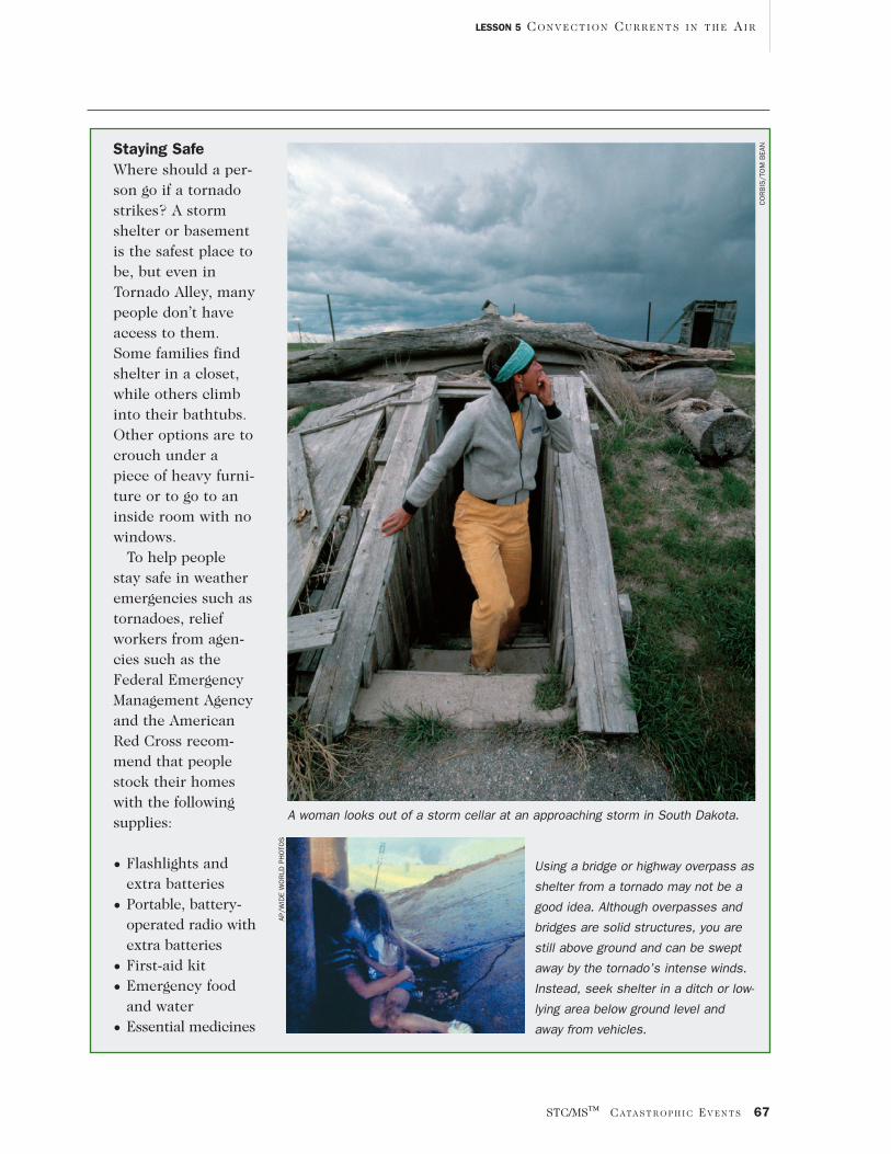
Staying SafeWhere should a per-son go if a tornadostrikes? A stormshelter or basementis the safest place tobe, but even inTornado Alley, manypeople don’t haveaccess to them.Some families findshelter in a closet,while others climbinto their bathtubs.Other options are tocrouch under apiece of heavy furni-ture or to go to aninside room with nowindows.
To help peoplestay safe in weatheremergencies such astornadoes, reliefworkers from agen-cies such as theFederal EmergencyManagement Agencyand the AmericanRed Cross recom-mend that peoplestock their homeswith the followingsupplies:
• Flashlights andextra batteries
• Portable, battery-operated radio withextra batteries
• First-aid kit
• Emergency foodand water
• Essential medicines
Using a bridge or highway overpass as
shelter from a tornado may not be a
good idea. Although overpasses and
bridges are solid structures, you are
still above ground and can be swept
away by the tornado’s intense winds.
Instead, seek shelter in a ditch or low-
lying area below ground level and
away from vehicles.
AP/W
IDE
WO
RLD
PH
OTO
S
A woman looks out of a storm cellar at an approaching storm in South Dakota.
CO
RB
IS/T
OM
BEA
N
Recommended