CRP1.1. North Africa and West AsiaSites Characteristics
Reducing Vulnerability and Managing Risk
Regional Inception WorkshopRabat, Morocco July 2-4, 2012

Syria-Jordan Site
AI: 0.05-0.35E-W & S-N gradient
Aridity Index
N

Climate/ Precipitation & PET
West-East gradient (400 to 100 mm)
High temporal variability of precipitation (CV% 23-60%)

Climate
Precipitation pattern: winter-rainfall, one long season (Sept/Oct to Apr/May, 90 %)
According to the IPCC 4th Assessment Report on CC: decline of 20-30% in the annual precipitation by the end of the 21st century
Drought is inherent feature recurring shock for cropping & livestock Expansion of irrigation and range reserves

Climate
Cold winters & hot summers Growing periods in the west: adequate
for crops, not in the EastDrought risk (1970-2009):
Early drought (Oct-Jan) Late drought (Feb-May) Seasonal drought (July-Aug) Frost risk: High in Feb. March
(Central Syria); low-moderate in Jordan (Feb.)

Soils/ Land use
Many good agricultural soils, Main limitations: shallow depth,
salinity, poor profile development, high gypsum content, indurated horizons (pans).
Landforms: plains 74.2%, hills 24.5%, mountains 1.3%

Land use
Rainfed cropland: 30 % Syria, 20 % Jordan Main rainfed crops: Wheat, barley, fruit trees, lentil,
chickpea Irrigated cropland: 5-10 % Jordan, 4 % Syria Irrigated crops:
Syria: vegetables, wheat, olive, pistachio, almonds, cumin
Jordan: vegetables and fruit trees Rangelands: 20 % Loss of biodiversity: important, mostly in rangelands Loss of soil OM: 70% of area affected Erosion: important water and wind erosion
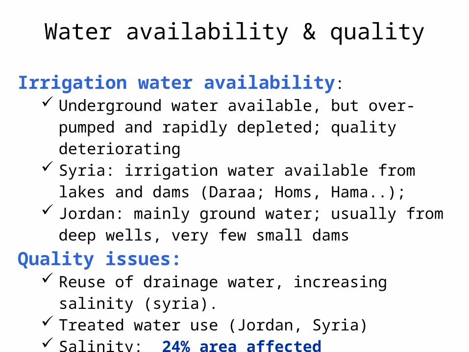
Water availability & quality
Irrigation water availability: Underground water available, but over-pumped and
rapidly depleted; quality deteriorating Syria: irrigation water available from lakes and dams
(Daraa; Homs, Hama..); Jordan: mainly ground water; usually from deep wells,
very few small dams
Quality issues: Reuse of drainage water, increasing salinity (syria). Treated water use (Jordan, Syria) Salinity: 24% area affected
Population, employment
Total population: 8.3; about 6.6 million in Syria and about 1.7 million in Jordan
Rural population: 60-70% Poverty: UNDP (2005) 11 %; in Khanasir 30 % under
poverty line. 13% of children in Syria under the age of 5 were underweight. Poverty is lower in the Jordan part (5 %)
Unemployment rate: ~ 10-25%, higher among youth Non-agricultural employment: 50 % (Government
jobs and business)
Access to market, land, … Degree of commercialization:
Market available for most of the products; Producers heavily depend on traders for capital
and market access. Access to land:
Open access for common rangeland, Private land - a weak land cadastral system (title,
disputes) Women face a major land access problem
(inheritance, 5 % only in Jordan, small plots) Extension: Generally weak, not up to date with
modern communication methods and largely underfunded. There are no female extension agents or very few, thus women are underserved

Livestock
Breeds: Awassi sheep, Shami goats; cattle (imported), imported and local poultry; some camels
Feedings systems: Rangelands (maximum 15%), barley grain, vetches, straw, stubble, wheat bran, crop
residues, agro-industrial by-products (olive cake, tomato pomace), by-products of vegetables in the irrigated areas.
Systems: Transhumant, semi-intensive, settled intensive (fattening or hand feeding)
Prevalent diseases: Foot and mouth disease , Brucella , sheep pox , enterotoxaemia , internal and external parasites.
Access to water, inputs & credits
Access to credits: Land registration needed Access to water:
Syria: Few wells with limited capacity, digging new wells is prohibited; 60 % of wells are not licensed, those established before 2001 cannot be regularized
Jordan: All wells are listed and have a water meter; priced at low rate; no price for water use for private dug wells
Access to inputs: no quality assurance for inputs (Seeds available but high risk)
Land fragmentation: A problem (credits), small plots are not registered

Land degradation
Important trends: permanent overgrazing of the rangelands, salinization of irrigated lands, soil erosion, and the aquifer depletion and contamination occurring in groundwater-irrigated systems
Wind erosion is common in the more arid parts of the Action Site
Water erosion of a geological nature is common near deeply incised rivers, such as the Orontes around Hama

Béni Khédache-Sidi Bouzid site

Precipitation & PET
100-150
250-300
1650
1350
80-237mm/year (CV:38 to 59 %)

Soils
Mostly shallow soils (20-100 cm), presence of some deep soils (up to 2 m)
Low organic matter: 77% of soils have OM < 1 %
More than 50% of the soils have poor profile development
High rockiness, stoniness (40-50 %)
70 % compact subsoils

Land use
Rainfed cropland 28 % (492680 ha) - Barley, olive trees, figs, almonds
Irrigated cropland
2 % (35334 ha including oasis) - Horticulture, fruit trees – Slight increase
Rangeland 64 % (1138052 ha)
Change of land use
Encroachment of rangeland by barley & olive trees

LAND DEGRADATION
- Salinization in irrigated area
- Important water erosion
- Severe wind erosion
- Loss of biodiversity in rangelands, invasive species
- Lowering of ground water table : 1-3 m/y

Livestock sector
Breeds: Barabarine sheep/60 %, Local Goat/30 % local, Camel/10 %
Feeding system: Rangeland: 20%, purchased feed: 40 %, 40 % cactus, olive cake and straw
Crop/livestock integration: High through the use of horticulture and barley crops residues
Major diseases: Metabolic disorders, transboundary diseases need attention
Vet services: Good

Population, employement
Total population: Around 1 million, 44 % rural
Poverty of rural population: 25 %
Non-agricultural employment: Government employees, construction work, tourism, textile industry (women poorly paid), transboundary activities
Average farm holding size: < 2 ha
Access to markets: Local: OK National: highly competitive Regional : active with Libya Global: exporters
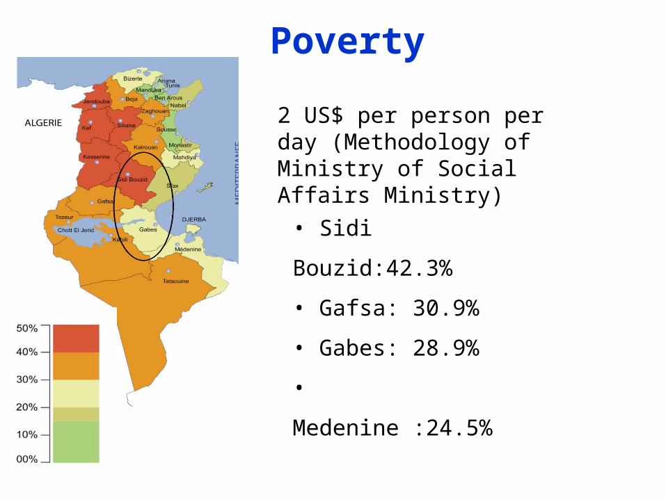
• Sidi Bouzid:42.3%
• Gafsa: 30.9%
• Gabes: 28.9%
• Medenine :24.5%
2 US$ per person per day (Methodology of Ministry of Social Affairs Ministry)
Poverty

Access to water and land
Irrigation water availability: Low, overexploitation of ground water Availability of runoff water Quality: Brackish ground water
Access to water: Water form deep aquifers and irrigated perimeters is
priced. Private wells are authorized for less than 50 m and in
not red spot areas
Access to land: 90 % of rangelands are collective; Most of crop land is private but not all of it with titles. Land fragmentation: an issue for rainfed areas

Production systems
For both sites, 2 major production systems:- Pastoral system (rangeland based
system/sheep & camel)- Agropastoral system (Barley-sheep based
system, Mixed rangeland-barley-tree based system)

Rangeland-based system/ Constraints
Encroachment of rangelands by barley and olive crops,
Degradation and overgrazing especially around watering points,
Livestock watering, and water points management Uprooting of vegetation for domestic use, Conflicts on grazing lands, Animal health problems, Climate variability (droughts, CC). Rejection of pastoral activity by young generation High unemployment and poverty rates (migration of
young people).

Rangeland-based system/ Opportunities
Important pastoral reserve for the region, Community-based rangeland management efficient &
well accepted Relatively important pastoral infrastructures, Existence of a specific Community-based
organization (CBOs) for the management of rangelands (GDA Dhahar)
Local know-how for rangeland management (resting, etc) and animal breeding
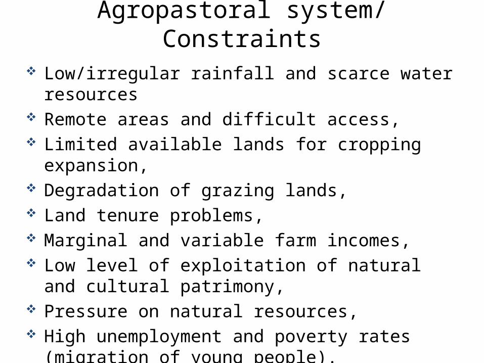
Agropastoral system/ Constraints
Low/irregular rainfall and scarce water resources Remote areas and difficult access, Limited available lands for cropping expansion, Degradation of grazing lands, Land tenure problems, Marginal and variable farm incomes, Low level of exploitation of natural and cultural
patrimony, Pressure on natural resources, High unemployment and poverty rates (migration of
young people).

Agropastoral system/ Opportunities
Better (relatively) climate conditions: temperature, rain, etc.
Important public and private agricultural development programs,
Specific agricultural products (sheep and goat meat, dry figs, olive oil, honey, etc.)
Important aromatic and medicinal plants and fruit trees, biodiversity
Well preserved local know-how (agriculture, etc.), Very active local organizations: NGOs, etc.
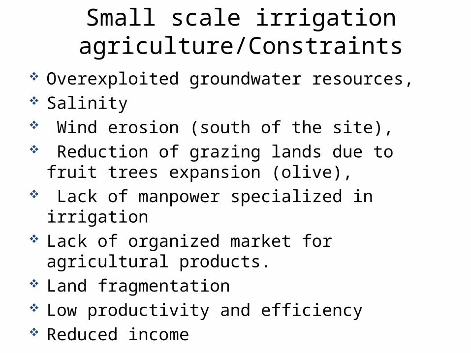
Small scale irrigation agriculture/Constraints
Overexploited groundwater resources, Salinity Wind erosion (south of the site), Reduction of grazing lands due to fruit trees
expansion (olive), Lack of manpower specialized in irrigation Lack of organized market for agricultural products. Land fragmentation Low productivity and efficiency Reduced income

Small scale irrigation agriculture/ Opportunities
Precocity of irrigated agricultural products compared to other regions
Settled land tenure favorable to investment, Available incentives to private investments, Easy access to local markets Great capacity to create job (employment) Export Contribution to the equilibrium of the national trade
balance

Hypotheses
Hypothesis 1The use of innovation platform (IP) in community-based organization of rangeland involving agro-pastoral stakeholders will help halt land degradation and restore ecosystems and improve livelihoodsHypothesis 2Rangeland production systems can be made less risky and more resilient by integrated technical, institutional and policy innovations that aim at rangeland rehabilitation and sustainable managementHypothesis 3Barley-sheep system productivity and resilience can be enhanced through integrated improvements in policy, institutional set-up and technologies (feed, health, adapted breeds), and markets (capital, input and product).

HypothesesHypothesis 4Integrating appropriate water harvesting as well as soil and water conservation practices will improve livestock productivity and reduce risks and vulnerability of agro-pastoral communities
Hypothesis 5System analysis including bioeconomic modeling and market analysis will facilitate policy and institutional changes and the outscaling of innovations
Hypothesis 6Equitable distribution of benefits and responsibilities through integration of youth and women will enhance economic development of the target areas
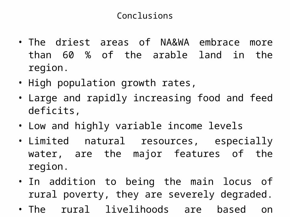
Conclusions
• The driest areas of NA&WA embrace more than 60 % of the arable land in the region.
• High population growth rates,
• Large and rapidly increasing food and feed deficits,
• Low and highly variable income levels
• Limited natural resources, especially water, are the major features of the region.
• In addition to being the main locus of rural poverty, they are severely degraded.
• The rural livelihoods are based on production systems in which small ruminants represent the principal economic output.
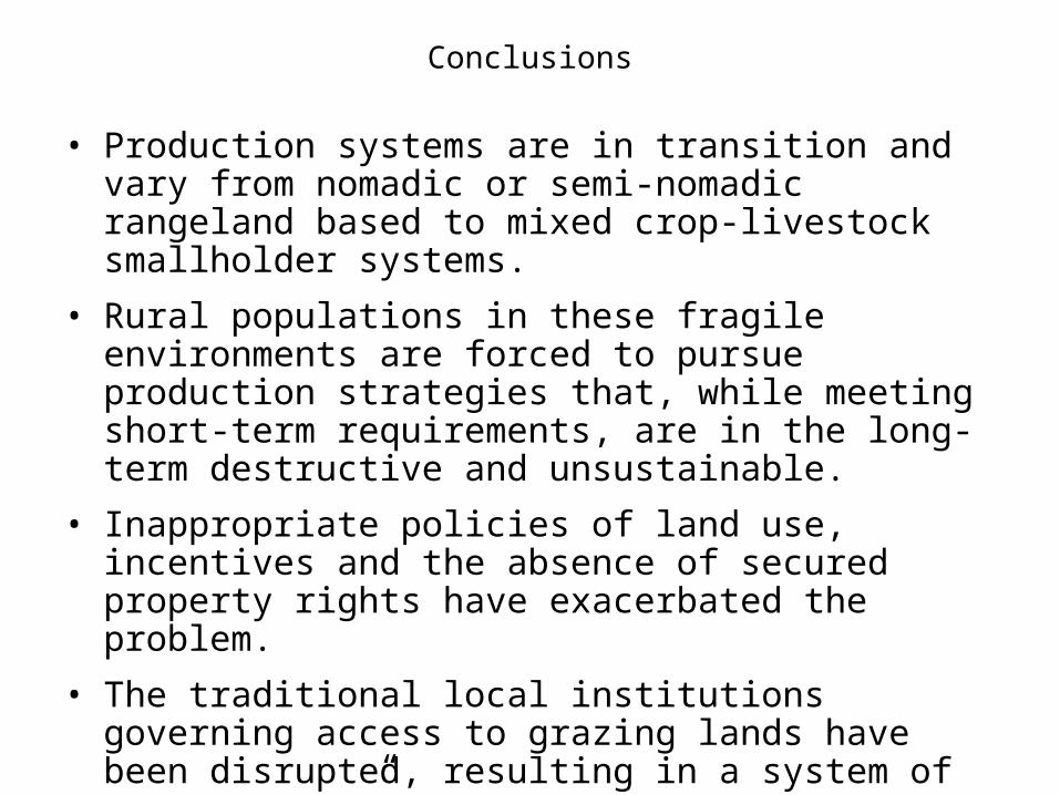
Conclusions
• Production systems are in transition and vary from nomadic or semi-nomadic rangeland based to mixed crop-livestock smallholder systems.
• Rural populations in these fragile environments are forced to pursue production strategies that, while meeting short-term requirements, are in the long-term destructive and unsustainable.
• Inappropriate policies of land use, incentives and the absence of secured property rights have exacerbated the problem.
• The traditional local institutions governing access to grazing lands have been disrupted, resulting in a system of "open access”.
Conclusions
• More frequent and prolonged droughts associated with global warming have worsened the vulnerability of agropastoral societies
• Although the rural poor may have limited resources, they still have considerable capacity to adapt to environmental degradation and to rehabilitate degraded resources.
• Experience showed that neither technical interventions nor policy adjustments alone will solve the problems. An innovative program of research for development integrating policy, institutional and technological options is capable of enhancing the resilience of the production systems and livelihoods.
Recommended
![Integrated and Sustainable Agricultural Production Systems for Improved Food Security and Livelihoods in Dry Areas [CRP1.1] Groundwork Report Sustainable](https://img.pdfslide.net/doc/110x75/56649e665503460f94b6058c/integrated-and-sustainable-agricultural-production-systems-for-improved-food.jpg)