Cumberland-Marlboro ‘basin’ basement drilling results – 2015: Cumberland,
Hoke and Scotland counties, North Carolina
By
Jeffrey C. Reid1 James L. Coleman, Jr.2
Kenneth B. Taylor1 Katherine J. Marciniak3
Walter T. Haven3 Ryan A. Channell3
Chandler I. Warner3
1North Carolina Geological Survey 2U.S. Geological Survey, Fayetteville, Georgia
3Energy Section
1,3Energy Group – Office of the Secretary North Carolina Department of Environmental Quality
North Carolina Geological Survey Open-file report 2016-01
February 24, 2016
Suggested citation: Reid, Jeffrey C.; Coleman, Jr., James L.; Taylor, Kenneth B.; Marciniak, Katherine J.; Haven, Walter T.;
Channell, Ryan A.; and Warner, Chandler I., 2016, North Carolina Geological Survey, Open-File Report 2016-01: Cumberland-
Marlboro ‘basin’ basement drilling results – 2015: Cumberland, Hoke and Scotland counties, North Carolina, 34 p.
NCGS Open-file report 2016-01 – Cumberland-Marlboro ‘basin’ basement drilling results 1
Cumberland-Marlboro ‘basin’ basement drilling results – 2015: Cumberland,
Hoke and Scotland counties, North Carolina
Abstract
State-funded continuous Rotasonic coring in the Cumberland-Marlboro basin (CMB) was undertaken to
evaluate the existence of a possible Triassic rift / lacustrine ‘basin’ beneath the Atlantic Coastal Plain for
on-shore hydrocarbon potential.
The CMB is represented by a large negative aeromagnetic anomaly buried beneath thin (200-400-feet-
thick) Coastal Plain sedimentary cover. The anomaly is strike parallel and seaward of the Triassic Deep
River rift basin previously assessed by the U.S. Geological Survey (USGS) for hydrocarbon potential.
Several documents in the geologic literature suggest that a Triassic rift / lacustrine basin may be present
coincident with this magnetic anomaly. The state groundwater well database (GW-1) provided
equivocal data suggesting the potential presence of Triassic strata and limited information on bedrock
well completions. Two basement studies present equivocal data that could be interpreted either as
paleo-weathering of metavolcanic or metasedimentary rocks or deeply weathered paleo-saprolite
developed on Triassic strata.
Three Rotasonic drill holes were advanced continuously from the surface into basement and recovered
fresh-, four-inch diameter cores of basement rock along the CMB anomaly’s strike extent at three
locations, one each in Cumberland, Hoke and Scotland counties, North Carolina. All three basement
cores encountered rock described in the field as metavolcanic rock and/or metasedimentary rock.
Petrographic study of thin sections indicates the basement rocks are of metasedimentary origin. Thus a
large Triassic rift / lacustrine basin is not the cause of the negative aeromagnetic anomaly that occurs
along strike where the holes were drilled. However, the presence of a smaller rift / lacustrine basin like
that found in Bertie County, or Camden County, North Carolina, cannot be precluded, and the CMB may
yet exist though significantly reduced size to that area in South Carolina suggested by water well data.
NCGS Open-file report 2016-01 – Cumberland-Marlboro ‘basin’ basement drilling results 2
Contents
Page
Abstract ............................................................................................................................................ 1
Contents……………………………………………………………………………………………………………………………………….. 2
Introduction……………………………………………………………………………………………………………………… 4 USGS Investigation into the Cumberland-Marlboro ‘basin’ of eastern North Carolina………... 4 Drilling results…………………………………………………………………………………………………………………... 6 Basement drill core descriptions and petrographic information……………………………………….. 7 Summary and conclusions………………………………………………………………………………………………… 8 References ………………………………………………………………………………………………………………………. 9 Acknowledgements …………………………………………………………………………………………………………. 10
Figures
1. Photograph of the Rotasonic drill rig used in this study……………………………………………………. 12
2. Map showing the location of the Cumberland-Marlboro ‘basin’ aeromagnetic anomaly …. 13
3. Well MLB-0183, Marlboro Co., South Carolina showing gamma-ray counts vs. depth …..…. 14
4. Map showing location of two South Carolina water wells……………………………………………….. 15
5. Map showing North Carolina wells penetrating basement rocks………………………………………. 16
6. Map showing Cumberland-Marlboro ‘basin’ groundwater wells in the GW-1 state
database and location of the three project drill holes ……….…………….………………………………. 17
7. Map showing aeromagnetic anomaly and project core hole locations…………………………..... 18
8. Basement core photographs of core hole CU-C-1-15…..…………..………...……………………………. 19
9. Photomicrograph of basement rocks in core hole CU-C-1-15, ~50x (wide field)…………….…. 20
10. Photomicrograph of basement rocks in core hole CU-C-1-15, 40x……………………………………. 21
11. Photomicrograph of basement rocks in core hole CU-C-1-15, 100x (Fig. 11a – plane
polarized light, Fig. 11b – cross polarized light) …….…………………………………………………………. 22
12. Basement core photographs of core hole HO-C-1-15……………………………………………………….. 24
13. Photomicrograph of basement rocks in core hole HO-C-1-15, ~50x (wide field)…………….…. 25
14. Photomicrograph of basement rocks in core hole HO-C-1-15, 40x …………………………………… 26
15. Photomicrograph of basement rocks in core hole HO-C-1-15, 100x (Fig. 15a – plane
polarized light, Fig. 15b – cross-polarized light ………………………………………………………………… 27
16. Basement core photograph of core hole SC-C-1-15………………………………………………………….. 29
17. Photomicrograph of basement rocks in core hole SC-C-1-15, ~50x (wide field)…………….…. 30
18. Photomicrograph of basement rocks in core hole SC-C-1-15, 40x ……………………………………. 31
19. Photomicrograph of basement rocks in core hole SC-C-1-15, 100x …………………………………. 32
20. Photomicrograph of basement rocks in core hole SC-C-1-15, 100x (Fig. 20a – plane
polarized light, Fig. 20b – cross polarized light) ………………………………………………………….…… 33
NCGS Open-file report 2016-01 – Cumberland-Marlboro ‘basin’ basement drilling results 3
Page
Table
1. Drill hole name, location, depth, and basement lithology…………………………………………………. 7
NCGS Open-file report 2016-01 – Cumberland-Marlboro ‘basin’ basement drilling results 4
Introduction
This report summarizes the North Carolina Geological Survey’s 2015 basement drilling investigations of
the unassessed Cumberland-Marlboro ‘basin’ (basin #1250701161 of the USGS’s national basin
inventory – see also Milici et al., 2012). The drilling objective was to determine the rock type
corresponding to a large negative aeromagnetic anomaly that is strike parallel and seaward of the Deep
River Triassic rift / lacustrine basin lying beneath a thin cover of unconsolidated Coastal Plain sediments.
Rotasonic coring through the thin (200-400 feet) overburden of the unconsolidated Coastal Plain
sediments recovered fresh 4-inch diameter Rotasonic cores of basement rock (Fig. 1). Drilling was
confined to ‘state owned’ land by direction of the North Carolina General Assembly in their FY2014-15
appropriation. Budget limitations controlled the number of holes that were drilled.
USGS Investigation into the Cumberland-Marlboro ‘basin’ of eastern North Carolina
As part of its ongoing assessment of the undiscovered, technically recoverable oil and natural gas
resources of the United States, in 2011 the U.S. Geological Survey (USGS) examined a number of
Mesozoic rift basins within the states bordering the Atlantic Ocean. This assessment concluded that a
mean of 3.86 trillion cubic feet of gas and 135 million barrels of natural gas liquids remain to be found in
five of these rift basins (Milici et al., 2012). These basins are the Taylorsville basin of Virginia and
Maryland, the Richmond basin of Virginia, the southern half of the Newark basin of New Jersey and
Pennsylvania, the Deep River basin of North Carolina, and the Dan River-Danville basin of North Carolina
and Virginia. These basins were assessed because there were sufficient data in the form of stratigraphic
and petroleum systems indications from drilled wells, outcrop sample analyses, and supporting
geophysical data (reflection seismic profiles and aeromagnetic anomaly maps). Coleman (2009)
provided an overview of the history of oil and gas exploration and petroleum geology of North Carolina
State Waters and the on-going USGS assessment of East Coast Mesozoic basins.
Other basins were identified and examined, but not assessed because of the lack of sufficient data to
confirm the potential presence of a petroleum system and possible petroleum accumulations. Those
basins examined, but not assessed are the Hartford basin, the north half of the Newark basin, the
Gettysburg basin, the Culpeper basin, several basins combined as the Delmarva basins, the Cumberland-
Marlboro ‘basin’, the Florence basin, the South Georgia basin and the North Florida basin. Detailed
geologic information on all of these and other identified onshore Atlantic coastal states Mesozoic rift
basins was presented in Coleman et al. (2015). This discussion of the Cumberland-Marlboro ‘basin’ is
extracted from Coleman et al. (2015) and older literature that originally proposed the existence of the
basin.
Several small Triassic basins occur beneath the North Carolina Coastal Plain. These include the Bertie
County basin (Weems et al., 2007), where clearly lacustrine strata have not been found. Richards
(1954a, 1954b) noted an apparent Triassic basin with a small show of gas in the duGrandlee Exploration
Co. well (with a total depth of 6,421 feet) from Camden County. In this instance, carbonaceous,
probably lacustrine shale was identified in drill cuttings from the Camden County well (Richards, 1954b).
NCGS Open-file report 2016-01 – Cumberland-Marlboro ‘basin’ basement drilling results 5
The Cumberland-Marlboro ‘basin’ was identified from anomalously low aeromagnetic data and the
presence of two water wells in Marlboro County, South Carolina (Benson, 1992). Benson identified
these two water wells as penetrating the Mesozoic rift strata, and these wells lay within the area of
anomalously low aeromagnetic character (Fig. 2; U. S. Geological Survey and National Geophysical Data
Center, 2002). No oil and gas wells had been drilled within the Cumberland-Marlboro ‘basin’ outline,
and no reflection seismic profiles were known to exist to confirm its presence.
This ‘basin’ had been previously interpreted by Bonini and Woollard (1960) and Bonini (1964) as a
"buried Triassic [b]asin" and given the name “Fayetteville basin”. Its identification was based on a lower
than expected basement velocity of 12,500 feet/second from refraction seismic data and interpretation
that two wells with bottom cuttings in sericitic phyllite and volcanic material were, in fact, "Triassic
sediments (?)". Schipf (1964) disagreed with Bonini (1964) citing his groundwater study data (Schipf,
1961) as evidence that the ‘basin’ was a geophysical anomaly (velocity and magnetic low) associated
with metavolcanic-epiclastic rocks of the Eastern Slate Belt (Brown et al., 1985). Schipf (1964) cited
records from 25 wells in the Fayetteville area which reached total depth in "slate", both according to
drillers' and Schipf's logs. Schipf (1964), however, recognized the possibility that the gray slates in these
wells might be gray shales of Triassic age, such as those of the Cumnock Formation in the Deep River
basin, but considered it “unlikely”.
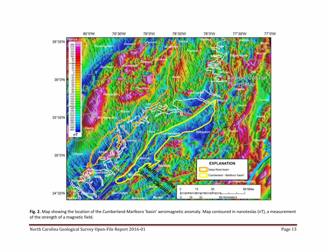
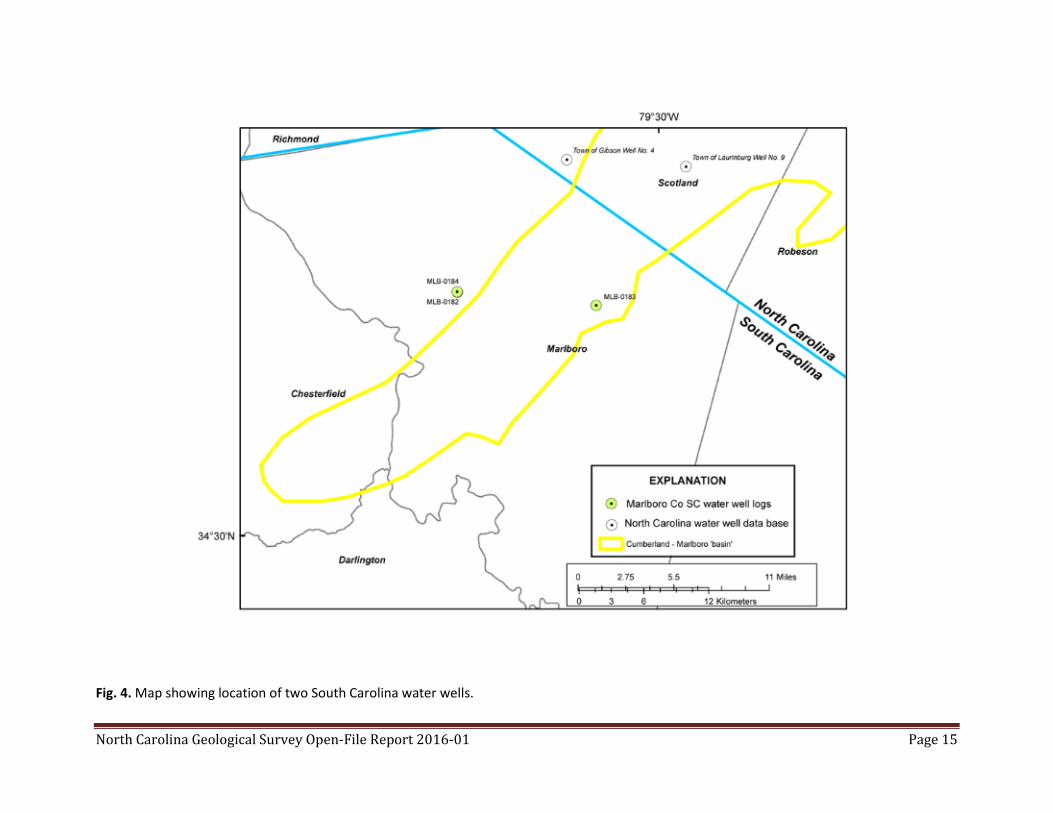
Examination of the water well data from Marlboro County, South Carolina, revealed that one well log
(MLB-0183, Figs. 3, 4) showed the possible presence of Mesozoic synrift sedimentary rock beneath
Cretaceous strata of the Atlantic Coastal Plain. The possible presence of Mesozoic synrift strata in the
two wells illustrated by Benson (1992) could not be confirmed from online South Carolina well data
(https://www.dnr.sc.gov/hydro/gl_home.html). Benson (1992) had previously described these wells as
penetrating “unmetamorphosed presumed lower Mesozoic (Upper Triassic-Lower Jurassic) synrift
sedimentary rock sand[stone] or diabase”. He did not illustrate any water wells from North Carolina with
these characteristics within the Cumberland-Marlboro ‘basin’ outline.
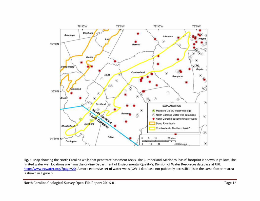
Examination of the few North Carolina water wells within the area of the Cumberland-Marlboro ‘basin’
encountered rocks potentially reflective of Mesozoic syn-rift sedimentary rocks (i.e., HO-P-1-70, "chips
of quartz-sericite phyllite...[with] some chips of fine-grained quartzite"; CD-P-1-67, "chips of
metagraywacke with a poor slaty cleavage..., relict sedimentary..., 80 percent of rock is ... quartz sand
and silt grains"; CD-T-1-86, “sericite phyllite and metasandstone chips consisting of quartz…, angular
sericite…, and minor carbonate”; and SA-T-1-XX, “chips of slaty metamudstone…[r]ock has no chlorite, is
very fine grained, and is only very slightly metamorphosed”; Lawrence and Hoffman, 1993). For well
locations see Lawrence and Hoffman (1993). Other than the phrase "poor slaty cleavage" and the
mention of "apparent" metamorphic magnetite, very minor chlorite, and white mica making up about
20% of one of the samples (CD-P-1-67), there were no other rock data available at the time to clearly
indicate metamorphic terrain as indicated by the other adjacent and surrounding wells (Lawrence and
Hoffman, 1993). These lithologies did not clearly condemn the potential presence of buried Mesozoic
rift basins; however, they do support the presence of a low aeromagnetic anomaly.
NCGS Open-file report 2016-01 – Cumberland-Marlboro ‘basin’ basement drilling results 6
The North Carolina Geological Survey (NCGS) well database (Nickerson and Hoffman, 1988) indicates
other wells within the ‘basin’ outline that might have encountered basement lithologies: CD-T-03-68
encountered metasiltstone as basement and SA-T-1-75, CD-P-1-78, CD-P-2-74, CD-T-2-78, apparently
reached basement based on geophysical logs, with no published reports of lithology (Fig. 5).
Because of the size, shape, geophysical interpretations, and the lack of clear petrographic evidence,
further investigations that would clarify the character of the Cumberland-Marlboro ‘basin’ (CMB) were
suggested. These investigations were recommended to include slim-hole coring using standard mining
and water well drilling equipment.
The State’s groundwater database (GW-1) located in the North Carolina Department of Environmental
Quality, Division of Water Resources was also queried for domestic water wells in the footprint of the
CMB (Fig. 2). North Carolina’s water well construction rules (15A NCAC 02C) require drillers to complete
a “Form GW-1, Well Construction Record” and submit it to the North Carolina Division of Water
Resources (DWR). Each form captures information on intended well use, total depth, casing, and
lithology as described by the driller. After receiving a GW-1 form, DWR personnel enter respective data
into their GW-1 database, which has been made available to the NC Geological Survey for this study.
The GW-1 database was used to compile water well construction data from the area outlined on the
map as the Cumberland-Marlboro ‘basin’ (CMB). The records were matched first via the postal codes
within the counties and then reprocessed to include only those data points within the outline of the
CMB itself. The three project rock core locations were plotted based on the coordinates in Table 1.
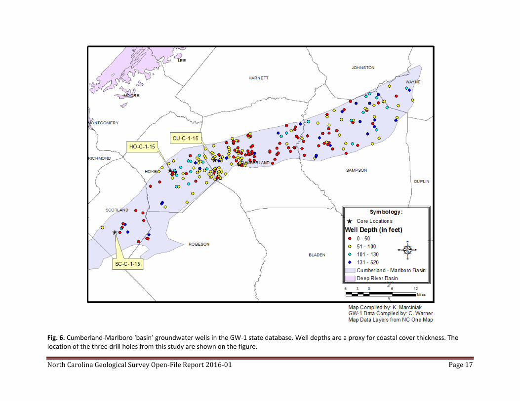
A total of 374 groundwater wells were identified within the CMB from either the given latitude and
longitude or on the computed latitude and longitude based on the given street address found on the
GW-1 form. These wells range in total depth from eight (8) feet to 520 feet. The majority of the water
wells plotted are shallow, less than 50 feet in depth, and correspond to either groundwater monitoring
wells or recovery wells; the wells deeper than 50 feet are classified as residential, irrigation, and
agriculture.
Based on the driller’s log provided on the GW-1 form, “green rock” was encountered in the CMB at
depths of 190 feet to 215 feet and “grey rock/black rock” was encountered at depths of 200 feet to 250
feet. Although helpful, using these records alone was not conclusive for determining basement rock
depth, as some of the GW-1 forms lacked sufficient, descriptive information. Of the 374 wells in the
footprint, only eight reached some type of hard rock. The depths of the wells reaching some type of
hard rock ranged from zero feet to about 215 feet. All the other wells appear to have reached a total
depth within the unconsolidated Coastal Plain strata.
Drilling results
Drill hole locations are shown in Figs. 6, 7; latitude and longitude coordinates are listed in Table 1. Fig. 6
shows drilling locations along with the CMB aeromagnetic low and county outlines. Five state land
parcels were selected for drilling. Of the five locations selected, three were drilled taking into account
the available budget and time required to complete this project and funds required for another drilling
NCGS Open-file report 2016-01 – Cumberland-Marlboro ‘basin’ basement drilling results 7
project in the Dan River basin, Stokes Co., North Carolina, before the end of the state fiscal year on 30
June 2015 (Fig. 7).
Drill hole names (e.g., CU-C-1-15) are CU = Cumberland County (HO = Hoke; SC = Scotland) followed by C
(core hole), 1 (ascension number for that country in the present year), and 15 (year the hole was drilled
(also see Nickerson and Hoffman, 1988). Thus CU-C-1-15 is the name of the first core hole drilled in
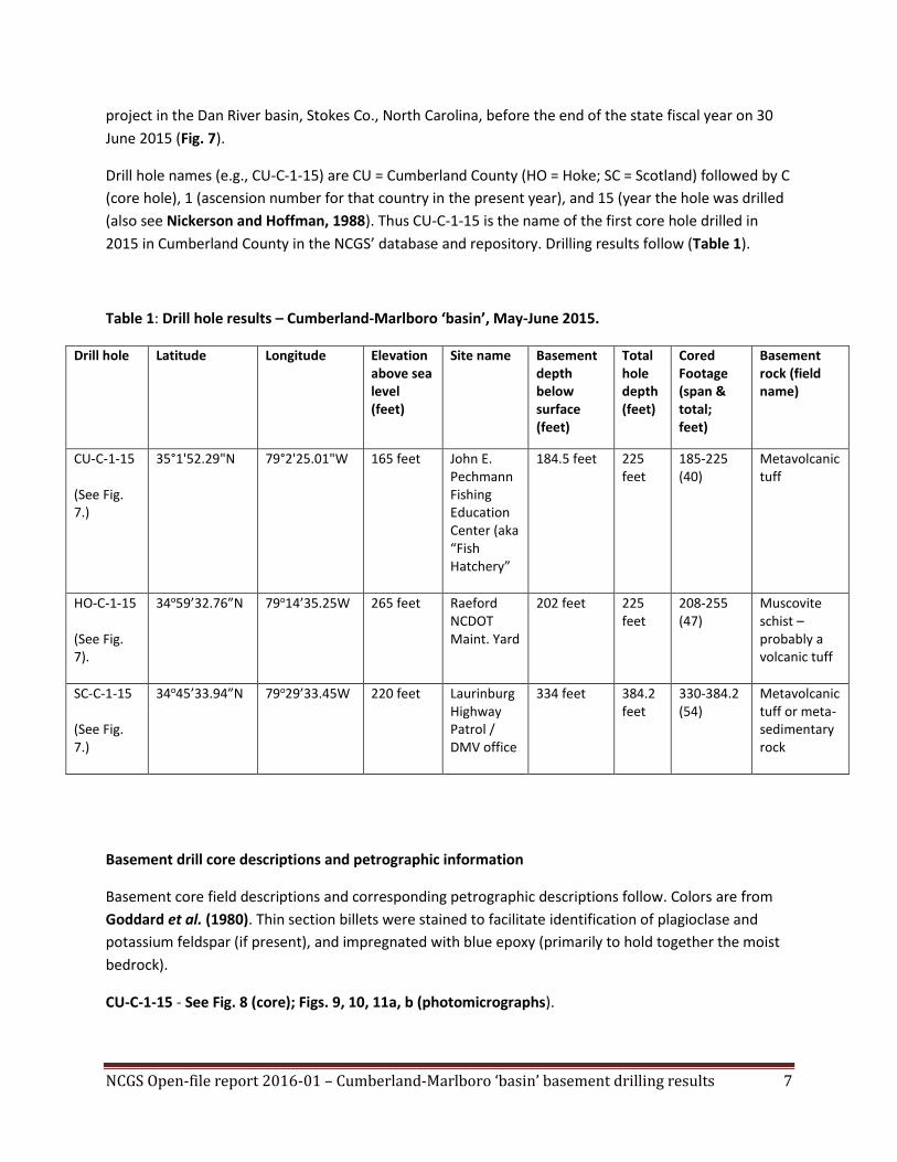
2015 in Cumberland County in the NCGS’ database and repository. Drilling results follow (Table 1).
Table 1: Drill hole results – Cumberland-Marlboro ‘basin’, May-June 2015.
Drill hole Latitude Longitude Elevation above sea level (feet)
Site name Basement depth below surface (feet)
Total hole depth (feet)
Cored Footage (span & total; feet)
Basement rock (field name)
CU-C-1-15 (See Fig. 7.)
35°1'52.29"N 79°2'25.01"W 165 feet John E. Pechmann Fishing Education Center (aka “Fish Hatchery”
184.5 feet 225 feet
185-225 (40)
Metavolcanic tuff
HO-C-1-15 (See Fig. 7).
34o59’32.76”N 79o14’35.25W 265 feet Raeford NCDOT Maint. Yard
202 feet 225 feet
208-255 (47)
Muscovite schist – probably a volcanic tuff
SC-C-1-15 (See Fig. 7.)
34o45’33.94”N 79o29’33.45W 220 feet Laurinburg Highway Patrol / DMV office
334 feet 384.2 feet
330-384.2 (54)
Metavolcanic tuff or meta-sedimentary rock
Basement drill core descriptions and petrographic information
Basement core field descriptions and corresponding petrographic descriptions follow. Colors are from
Goddard et al. (1980). Thin section billets were stained to facilitate identification of plagioclase and
potassium feldspar (if present), and impregnated with blue epoxy (primarily to hold together the moist
bedrock).
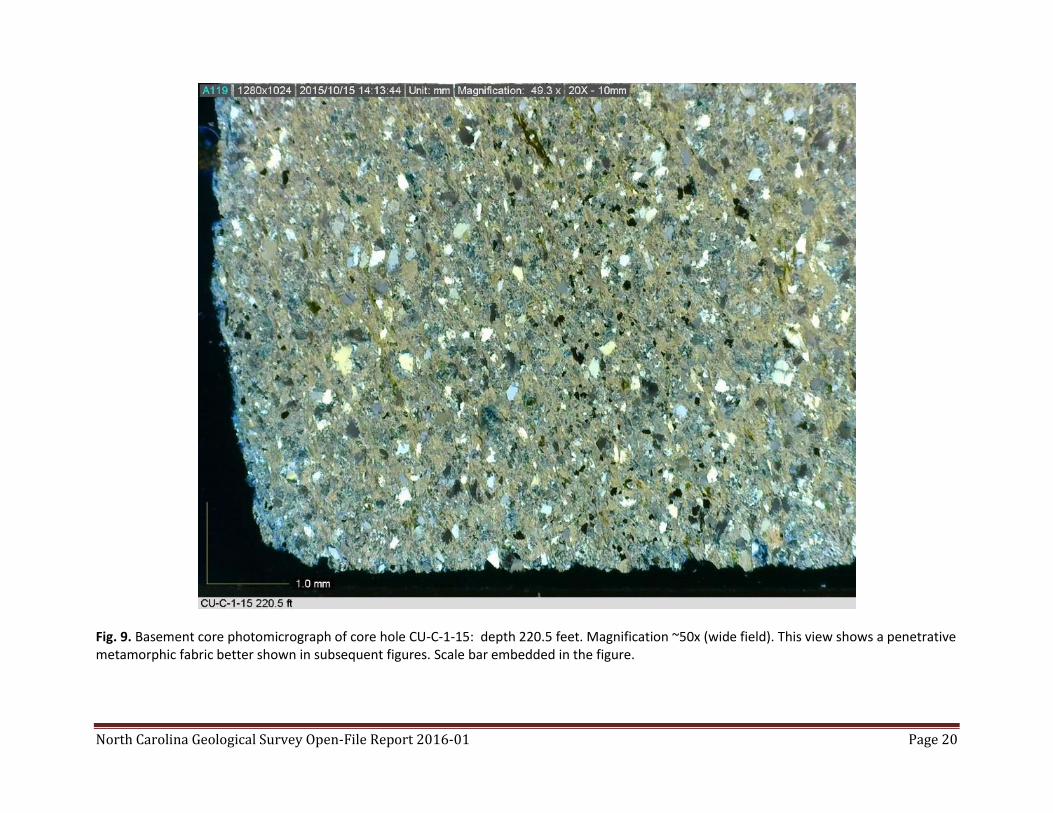
CU-C-1-15 - See Fig. 8 (core); Figs. 9, 10, 11a, b (photomicrographs).
NCGS Open-file report 2016-01 – Cumberland-Marlboro ‘basin’ basement drilling results 8
Core description (field): Metavolcanic tuff (5GY 7/2), foliated. Washed core samples indicate a well
foliated rock.
Petrographic description: Foliated chlorite-graphite-muscovite-quartz schist with accessory zircon. The
graphite is disseminated and locally clumped. The zircon is rounded and in some cases spherical.
HO-C-1-15 - See Fig. 12 (core), Figs. 13, 14, 15a, b (photomicrographs).
Core description (field): Paleosaprolite grading downward into muscovite schist (10 GY 5/2) or possibly
a schist with a metavolcanic protolith. Washed core samples indicate a well foliated rock.
Petrographic description: Well foliated graphite-muscovite-quartz schist with accessory zircon. The
zircon is rounded. Cross crenulations indicate a complex structural history.
SC-C-1-15 - See Fig. 16 (core); Figs. 17, 18, 19, 20a, b (photomicrographs).
Core description (field): Metavolcanic tuff or metasediment (5BG 5/2). Washed core samples indicate a
well foliated rock.
Petrographic description: Foliated graphite?-bearing biotite-muscovite quartz schist with accessory
rounded zircon. Incipient biotite poikilitically encloses graphite, muscovite and quartz (Fig. 16). Portions
of biotites have metamict textures.
Summary and conclusions
Based on recently acquired subsurface cores, the Cumberland-Marlboro ‘basin’ is not a large strike
parallel Triassic rift / lacustrine basin seaward of the Deep River Triassic rift / lacustrine basin as
proposed by Bonini (1964), Bonini and Wollard (1960), and accepted by Milci et al. (2012).
The CMB basement rocks are metamorphic volcanic and meta-sedimentary (?) rocks that are probably
older than Triassic age.
Triassic rift / lacustrine basins are known from drilling elsewhere under North Carolina’s coastal plain in
Bertie County and Camden County. Their aeromagnetic signature indicates that these basins are likely
very small. No lacustrine strata have been identified in the Bertie County basin. In the case of the CMB,
the presence of a small Triassic rift / lacustrine basin of comparable size to that of the Bertie County
basin or that of Camden County cannot be precluded.
Representative core intervals from each core through the coastal plain strata, and the basement cores,
are stored in the North Carolina Geological Survey’s core repository in Raleigh, North Carolina. Contact
the State Geologist to examine core, cuttings, and drill logs.
NCGS Open-file report 2016-01 – Cumberland-Marlboro ‘basin’ basement drilling results 9
Core drilling is a cost effective tool to ascertain the nature of geophysical anomalies beneath thin coastal
plain cover.
References
Benson, R.H., 1992, Map of exposed and buried early Mesozoic rift basins/synrift rocks of the U.S.
middle Atlantic continental margin: Delaware Geological Survey Miscellaneous Map Series 5, 1 sheet,
scale 1:1,000,000.
Bonini, W.E., 1964, Is there a Fayetteville "buried Triassic basin?": American Association of Petroleum
Geologists Bulletin, v. 48, p. 102.
Bonini, W.E., and Woollard, G.P., 1960, Subsurface geology of North Carolina - South Carolina coastal
plain from seismic data: American Association of Petroleum Geologists Bulletin v. 44, p. 298 - 315.
Brown, P.M., et al., compilers, 1985, Geologic map of North Carolina: North Carolina Department of
Natural Resources and Community Development, 1 sheet, 1:500,000.
Coleman, J.L., Jr., April 15, 2009, Status of Investigations into the Oil and Gas Resource Potential of the
Onshore Lands and State Waters of North Carolina, (available online at
http://www.ncleg.net/documentsites/committees/OEESC/4-15-
09%20Meeting/Status%20of%20Invest%20into%20the%20O&G%20Res%20Potential%20-
%20NC_rev.pdf; the illustrations are at URL
http://www.ncleg.net/documentsites/committees/OEESC/4-15-09%20Meeting/Resources-USGS.pdf).
Coleman, J.L., Jr.; Milici, R.C.; and Post, P.J., 2015, Assessment of the Oil and Natural Gas Potential of the
East Coast Mesozoic Rift Basins, Onshore and State Waters of the United States, in Post, P.J.; Coleman, J.
L., Jr.; Brown, D., et al., editors, Petroleum systems in “rift” basins: 34th Annual GCSSEPM Foundation
Perkins-Rosen Research Conference Proceedings, December 13-16, 2015, Houston, TX.
Goddard, E.N.; Trask, Parker D.; DeFord, Ronald K.; Rove, Olaf N.; Singlewald, Jr.; Joseph T.; and
Overbeck, R.M., representing The Rock-Color Chart Committee, 1980, Rock color chart: Distributed by
the Geological Society of America.
Lawrence, D.P., and Hoffman, C.W., 1993, Geology of basement rocks beneath the North Carolina
coastal plain: North Carolina Geological Survey Bulletin 95, 60 p., 1 sheet, scale 1:500,000.
Milici, R.C.; Coleman, J.L., Jr.; Rowan, E.L.; Cook, T.A.; Charpentier, R.R.; Kirschbaum, M.A.; Klett, T.R.;
Pollastro, R.M.; and Schenk, C.J., 2012, Assessment of undiscovered oil and gas resources of the east
coast Mesozoic basins of the Piedmont, Blue Ridge thrust belt, Atlantic Coastal Plain, and New England
Provinces, 2011, U.S. Geological Survey Fact Sheet 2012-3075, 2 p. (Also available at
http://pubs.usgs.gov/fs/2012/3075/.)
NCGS Open-file report 2016-01 – Cumberland-Marlboro ‘basin’ basement drilling results 10
Nickerson, J.G., and Hoffman, C.W., 1988, North Carolina Geological Survey Sample Repository of core,
cuttings and well logs: North Carolina Geological Survey Open-File Report 88-1, 5 p. accompanied by six
data sheet maps. Electronic copies of the data listing are now available in MS Excel format upon request.
Richards, H.G., 1954a, Developments in Atlantic coastal states between New Jersey and South Carolina
in 1953: American Association of Petroleum Geologists Bulletin, v. 38, pp. 1252-1253.
Richards, H.G., 1954b, Subsurface Triassic in Eastern North Carolina: American Association of Petroleum
Geologists Bulletin, v. 38, pp. 2564-2565.
Schipf, R.G., 1961, Geology and ground-water resources of the Fayetteville area: North Carolina
Department of Water Resources Ground Water Bulletin 3, 99 p.
Schipf, R.G., 1964, Fayetteville "buried Triassic basin": American Association of Petroleum Geologists
Bulletin, v. 48, p. 721-723.
U.S. Geological Survey and National Geophysical Data Center, 2002, Digital aeromagnetic datasets for
the conterminous United States and Hawaii–a companion to the North American magnetic anomaly
map: U.S. Geological Survey Open-File Report 02-361 (available online at
http://pubs.usgs.gov/of/2002/ofr-02-361/mag_home.htm).
Weems, R.E.; Seefelt, E.L.; Wrenge, B.M.; Self-Trail, J.M.; Prowell, D.C.; Durand, C.; Cobbs, E.F., III; and
McKinney, K.C., 2007, Preliminary physical stratigraphy and geophysical data of the USGS Hope
Plantation Core (BE-110), Bertie County, North Carolina: U.S. Geological Survey Open-File Report 2007-
1251, 63 p. (available online at http://pubs.usgs.gov/of/2007/1251/)
Acknowledgements
Funding for the drilling component of this project was provided by the North Carolina General Assembly
(FY 2014-15) to investigate the CMB.
We want to thank the North Carolina Department of Transportation (NCDOT), and in particular, Mr.
Charles Vick, Maintenance Engineer for Hoke and Scotland counties, North Carolina, for permission to
drill holes in the NCDOT maintenance yards.
We want to thank the North Carolina Wildlife Commission for permission to drill at the John E.
Pechmann Fishing Education Center, Fayetteville, North Carolina. This is the location of the Cumberland
County “Fish Hatchery” core hole. Mr. Gerald Klauss and Mr. Kris Smith (site manager) provided
invaluable information and assistance. Ms. Christina J. Jester of Bill’s Well Drilling Co., Inc. provided a
driller’s log for the water well at the John E. Pechmann Fishing Education Center (Cumberland County).
NCGS Open-file report 2016-01 – Cumberland-Marlboro ‘basin’ basement drilling results 11
We also want to thank Colonel William J. Grey, commander of the North Carolina State Highway Patrol,
for permission to drill at the Laurinburg Highway Patrol station (Scotland County).
Mr. Orus F. Patterson III, Patterson Exploration Services, Inc., Sanford, North Carolina, was the drilling
contractor. The Rotasonic holes were drilled by Terra Sonic International in May and early June 2015.
We also thank Matt Merrill and Robert Milici, U.S. Geological Survey, for their thoughtful review.
North Carolina Geological Survey Open-File Report 2016-01 Page 12
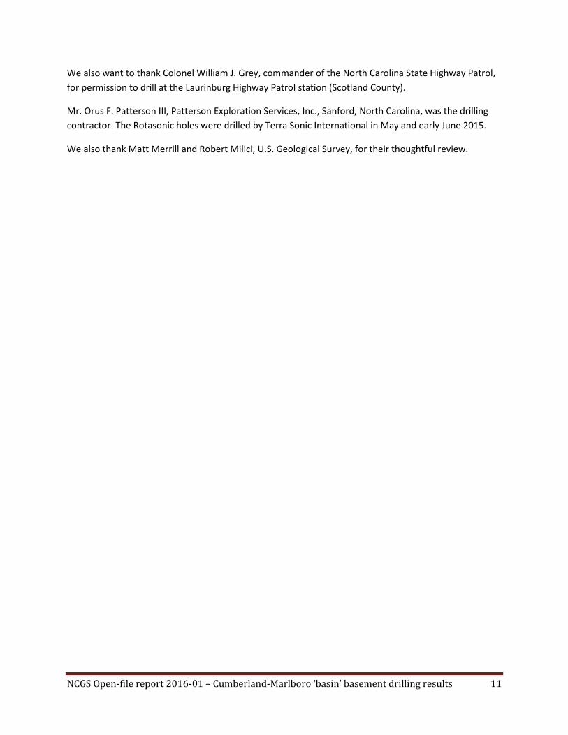
Fig. 1. Rotasonic drill used for the Cumberland-Marlboro ‘basin’ investigation. This is drill hole site HO-C-1-15 at the Department of Transportation maintenance yard, Hoke County, North Carolina. Rotasonic (sonic drilling) consists of three steps: Step 1 – Advance core barrel using sonic frequencies. This step can be performed using no fluids, air, or mud. Step 2 – Casing override – After the core barrel is in place, casing is sonically advanced over the core barrel to protect the borehole’s integrity in loose unconsolidated ground. Step 3 – Core retrieval – The core barrel is retrieved, producing a relatively undisturbed sample with near 100% core recovery. Steps 1-3 are repeated to depth.
North Carolina Geological Survey Open-File Report 2016-01 Page 13
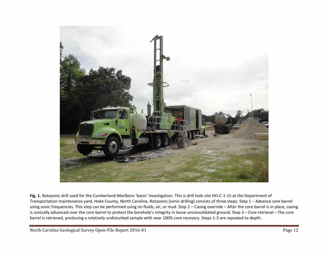
Fig. 2. Map showing the location of the Cumberland-Marlboro ‘basin’ aeromagnetic anomaly. Map contoured in nanoteslas (nT), a measurement of the strength of a magnetic field.
North Carolina Geological Survey Open-File Report 2016-01 Page 14
Fig. 3. Well MLB-0183, Marlboro County, South Carolina showing gamma-ray counts vs. depth.
Gamma Ray (counts per second)
Depth (feet)
North Carolina Geological Survey Open-File Report 2016-01 Page 15
Fig. 4. Map showing location of two South Carolina water wells.
North Carolina Geological Survey Open-File Report 2016-01 Page 16
Fig. 5. Map showing the North Carolina wells that penetrate basement rocks. The Cumberland-Marlboro ‘basin’ footprint is shown in yellow. The limited water well locations are from the on-line Department of Environmental Quality’s, Division of Water Resources database at URL http://www.ncwater.org/?page=20. A more extensive set of water wells (GW-1 database not publically accessible) is in the same footprint area is shown in Figure 6.
North Carolina Geological Survey Open-File Report 2016-01 Page 17
Fig. 6. Cumberland-Marlboro ‘basin’ groundwater wells in the GW-1 state database. Well depths are a proxy for coastal cover thickness. The location of the three drill holes from this study are shown on the figure.

North Carolina Geological Survey Open-File Report 2016-01 Page 18
Fig. 7. Map showing aeromagnetic anomaly and project core hole locations. Map contoured in nanoteslas (nT).
CU-C-1-15
HO-C-1-15
SC-C-1-15

North Carolina Geological Survey Open-File Report 2016-01 Page 19
Fig. 8. Basement core photographs of core hole CU-C-1-15: (top) depth 220.5 feet; (bottom) depth 225 feet.
North Carolina Geological Survey Open-File Report 2016-01 Page 20
Fig. 9. Basement core photomicrograph of core hole CU-C-1-15: depth 220.5 feet. Magnification ~50x (wide field). This view shows a penetrative metamorphic fabric better shown in subsequent figures. Scale bar embedded in the figure.

North Carolina Geological Survey Open-File Report 2016-01 Page 21
Fig. 10. Photomicrograph of basement rocks in core hole CU-C-1-15, depth 218 feet. Plane light, 40x; field of view width is about 28 mm. A
metamorphic foliation penetrates the rock. Quartz and subordinate feldspars and fine-grained metamorphic minerals with accessory biotite and
some magnetite (?) comprise this rock. Trace amounts of rounded zircons (center of field of view) with possible overgrowths suggest a
metasedimentary protolith.
Zircon

North Carolina Geological Survey Open-File Report 2016-01 Page 22
Fig. 11a. Photomicrograph of basement rocks in core hole CU-C-1-15, depth 218 feet. Plane light, 100x; field of view width is about 10 mm. A
metamorphic foliation penetrates the rock. Quartz and subordinate feldspars and fine-grained metamorphic minerals with accessory biotite and
some magnetite (?) comprise this rock. Trace amounts of rounded zircons (center of field of view) with possible overgrowths suggest a
metasedimentary protolith.
Zircon
North Carolina Geological Survey Open-File Report 2016-01 Page 23
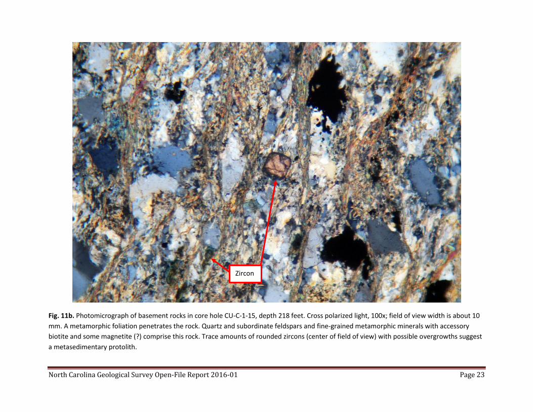
Fig. 11b. Photomicrograph of basement rocks in core hole CU-C-1-15, depth 218 feet. Cross polarized light, 100x; field of view width is about 10
mm. A metamorphic foliation penetrates the rock. Quartz and subordinate feldspars and fine-grained metamorphic minerals with accessory
biotite and some magnetite (?) comprise this rock. Trace amounts of rounded zircons (center of field of view) with possible overgrowths suggest
a metasedimentary protolith.
Zircon
North Carolina Geological Survey Open-File Report 2016-01 Page 24
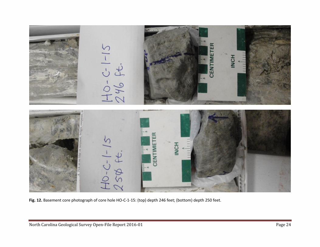
Fig. 12. Basement core photograph of core hole HO-C-1-15: (top) depth 246 feet; (bottom) depth 250 feet.

North Carolina Geological Survey Open-File Report 2016-01 Page 25
Fig. 13. Basement core photomicrograph of core hole HO-C-1-15: depth 246 feet. Magnification ~50x (wide field). The distinctive metamorphic
crenulations of the metamorphic foliation are clearly shown. Well foliated quartz-muscovite schist with accessory graphite and magnetite (?).
The foliation is crenulated suggesting slip. Scale bar embedded in the figure.
North Carolina Geological Survey Open-File Report 2016-01 Page 26
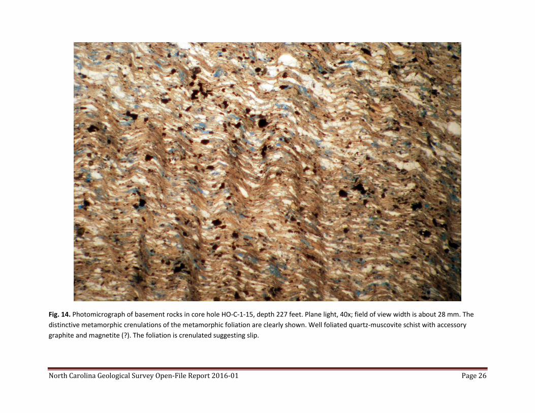
Fig. 14. Photomicrograph of basement rocks in core hole HO-C-1-15, depth 227 feet. Plane light, 40x; field of view width is about 28 mm. The
distinctive metamorphic crenulations of the metamorphic foliation are clearly shown. Well foliated quartz-muscovite schist with accessory
graphite and magnetite (?). The foliation is crenulated suggesting slip.

North Carolina Geological Survey Open-File Report 2016-01 Page 27
Fig. 15a. Photomicrograph of basement rocks in core hole HO-C-1-15, depth 247.5 feet. Plane light, 100x; field of view width is about 10 mm.
The distinctive metamorphic crenulations of the metamorphic foliation are clearly shown. Well foliated quartz-muscovite schist with accessory
graphite and magnetite (?). The foliation is crenulated suggesting slip.
Zircon
North Carolina Geological Survey Open-File Report 2016-01 Page 28
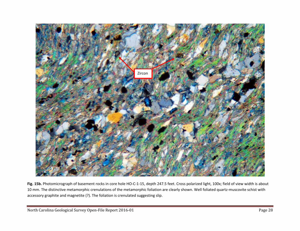
Fig. 15b. Photomicrograph of basement rocks in core hole HO-C-1-15, depth 247.5 feet. Cross polarized light, 100x; field of view width is about
10 mm. The distinctive metamorphic crenulations of the metamorphic foliation are clearly shown. Well foliated quartz-muscovite schist with
accessory graphite and magnetite (?). The foliation is crenulated suggesting slip.
Zircon
North Carolina Geological Survey Open-File Report 2016-01 Page 29
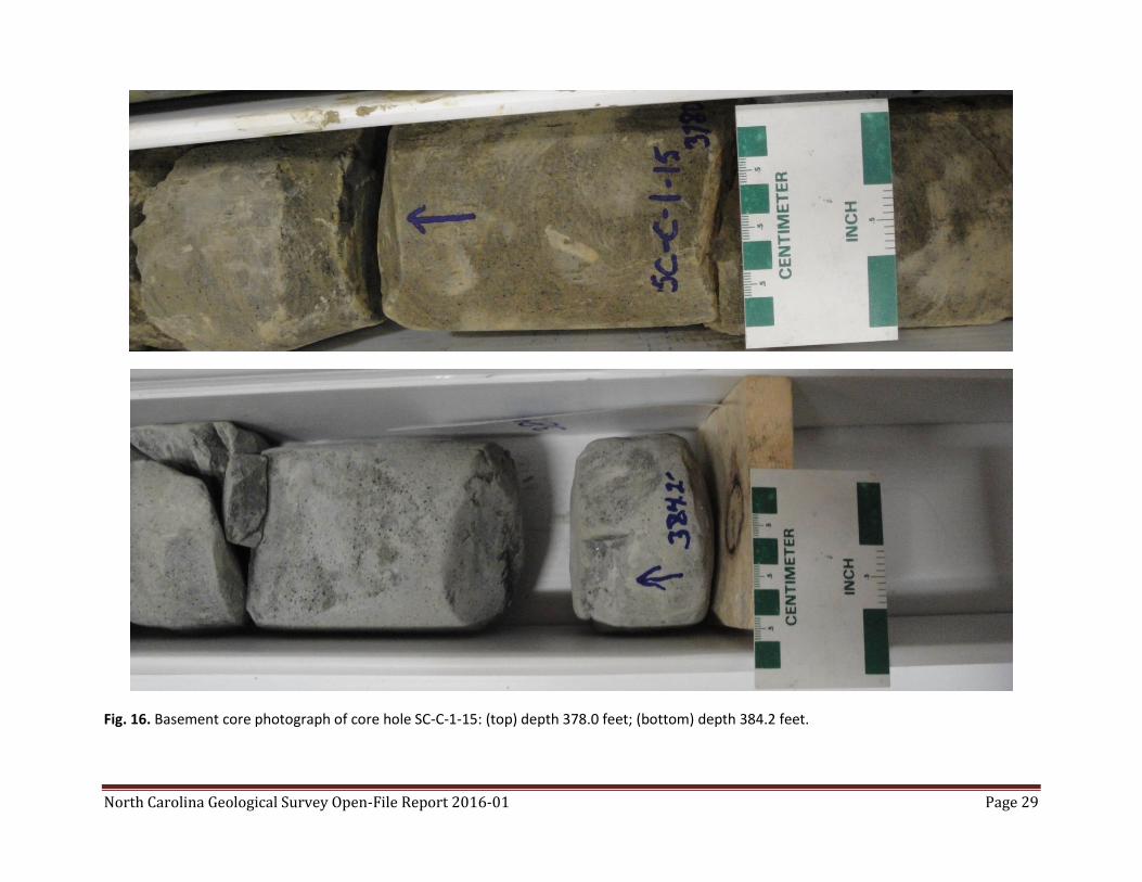
Fig. 16. Basement core photograph of core hole SC-C-1-15: (top) depth 378.0 feet; (bottom) depth 384.2 feet.

North Carolina Geological Survey Open-File Report 2016-01 Page 30
Fig. 17. Basement core photomicrograph of core hole SC-C-1-15: depth 378.0 feet. Magnification ~50x (wide field). Large poikilitic clots of biotite
appear to replace chlorite. Quartz and feldspar are other framework minerals. Accessory magnetite and graphite (?) are present. Compositional
banding and foliation are evident in this image. Scale bar embedded in the figure.
North Carolina Geological Survey Open-File Report 2016-01 Page 31
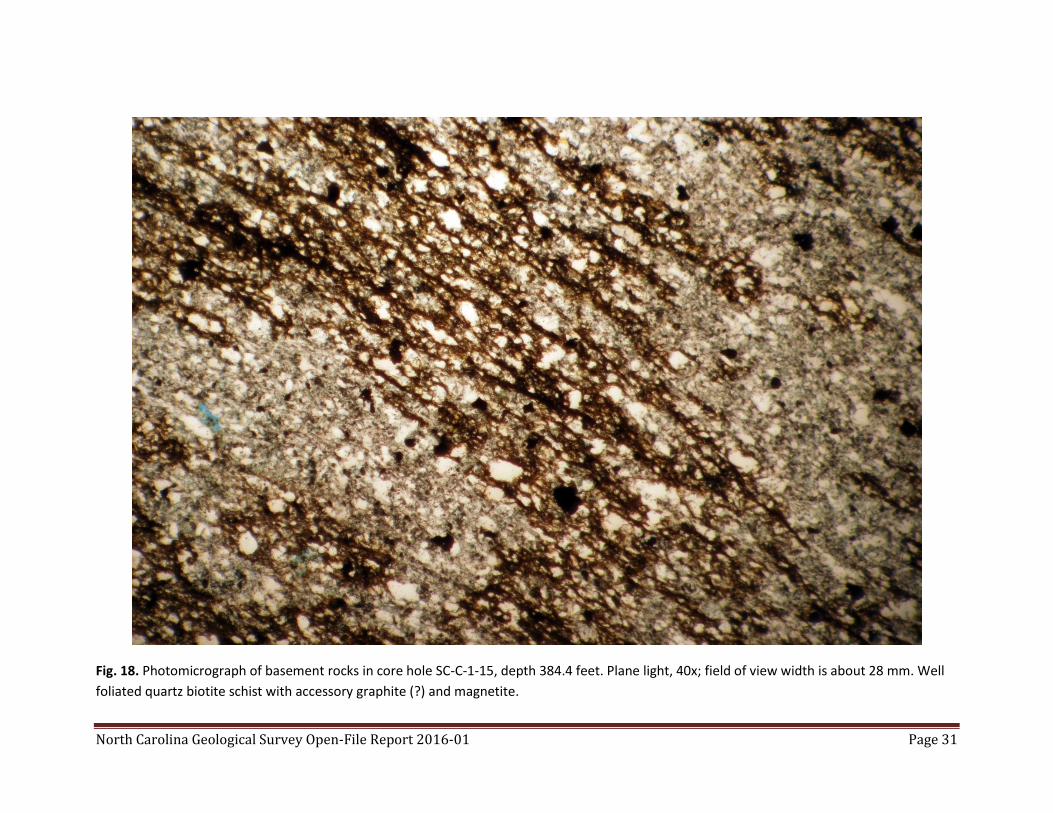
Fig. 18. Photomicrograph of basement rocks in core hole SC-C-1-15, depth 384.4 feet. Plane light, 40x; field of view width is about 28 mm. Well
foliated quartz biotite schist with accessory graphite (?) and magnetite.

North Carolina Geological Survey Open-File Report 2016-01 Page 32
Fig. 19. Photomicrograph of basement rocks in core hole SC-C-1-15, depth 384.4 feet. Plane light, 100x; field of view width is about 10 mm.
Poikolitic biotite replaces chlorite (?) and surrounds quartz. The opaque black minerals are thought to be magnetite. Quartz, fine-grained
feldspar, and chlorite comprise the remainder of the rock. Metamict texture is visible in the biotite (left center and center of field of view).
North Carolina Geological Survey Open-File Report 2016-01 Page 33
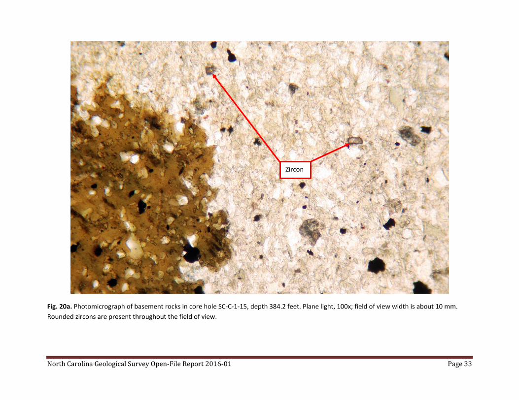
Fig. 20a. Photomicrograph of basement rocks in core hole SC-C-1-15, depth 384.2 feet. Plane light, 100x; field of view width is about 10 mm.
Rounded zircons are present throughout the field of view.
Zircon

North Carolina Geological Survey Open-File Report 2016-01 Page 34
Fig. 20b. Photomicrograph of basement rocks in core hole SC-C-1-15, depth 384.2 feet. Cross polarized light, 100x; field of view width is about 10
mm. Rounded zircons are present throughout the field of view.
Zircon
Recommended