Project : Development of Stretch between Pankapal to Dhamra and Paradip of National Waterway No. 5 in the State of Odisha for Inland Navigation
Document : Feasibility Report
Page:1
FEASIBILITY REPORT
Development of Stretch between Dhamra and Paradip to Pankapal
of National Waterway No. 5 in the State of Odisha
1.0 INTRODUCTION AND BACKGROUND
National Waterways No. 5 consisting of East Coast Canal along with Brahmani,
Kharsuan, Tantighai-Kani river system and Mahanadi delta rivers for a length of 588 Km
has been declared as National Waterways with effect from 25th November 2008 for
shipping and navigation to promote inland water transport. The stretch wise breakup of
NW-5 is as given below:
1. River Brahmani- (Talcher to Pankapal) - 120 km
2. Rivers Brahmani – Kharsua – Kani-Brahmani-(Pankapal to Mangalgadi ) - 117 km
3. Rivers Brahmani-Dhamra-(Mangalgadi to Dhamra) - 28 km
4. River Brahmani – open sea-Kharanasi creek-Mahanadi delta rivers
(Mangalgadi to Paradip) - 67 km
5. River-Matai - (Dhamra to Charbatia) - 39 km
6. East Coast Canal (Charbatia - Geonkhali) - 217 km
Total = 588 km
Figure-1 Index map of NW-5
Inland Waterways Authority of India, a statutory body under the Ministry of Shipping
has been entrusted the responsibility for development, management, maintenance and
regulation of the waterways with necessary infrastructures to ensure safe navigation. A
policy decision has been taken initially to develop the commercially viable stretch
Project : Development of Stretch between Pankapal to Dhamra and Paradip of National Waterway No. 5 in the State of Odisha for Inland Navigation
Document : Feasibility Report
Page:2
between Talcher to Paradip & Dhamra having a length of 332 km for providing the
sustainable and economically viable & alternative mode of transport from the ports to
mining area, industrial hubs & vice-versa for movement of coal, iron ore, other minerals,
thermal (imported) coals and industrial products etc.
Accordingly, one MOU with the major stake holders i.e. Govt. of Odisha, Paradip Port
Trust (PPT) & Dhamra Port Company Ltd. (DPCL) was signed by IWAI on 30.06.2014
for developing the above stretches of NW-5 in two phases.
• 1st Phase= 212 km between Pankapal to Dhamra & Paradip
• 2nd Phase= 120 km between Talcher to Pankapal
Development of NW-5 under Phase-I is to be taken up on priority basis with the
following major work components:
(i) Fairway Development: with LAD of 3 m, through construction of barrages, check
dams and barrages with navigation locks, maintenance dredging wherever required,
widening of river, straightening of bends and river training works including bank
protection, re-construction of existing bridges and relaying of existing power lines
across the waterway to provide required navigational clearance.
(ii) Terminal facility: with required jetties & cargo handling equipments at Pankapal,
whereas existing terminal facilities of Dhamra and Paradip Ports will be utilized.
(iii) Navigational Aids: To introduce 24 hrs navigation.
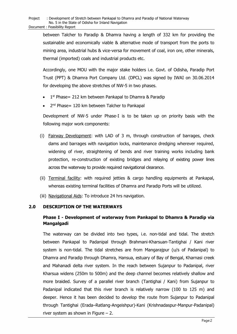
2.0 DESCRIPTION OF THE WATERWAYS
Phase I - Development of waterway from Pankapal to Dhamra & Paradip via
Mangalgadi
The waterway can be divided into two types, i.e. non-tidal and tidal. The stretch
between Pankapal to Padanipal through Brahmani-Kharsuan-Tantighai / Kani river
system is non-tidal. The tidal stretches are from Mangarajpur (u/s of Padanipal) to
Dhamra and Paradip through Dhamra, Hansua, estuary of Bay of Bengal, Kharnasi creek
and Mahanadi delta river system. In the reach between Sujanpur to Padanipal, river
Kharsua widens (250m to 500m) and the deep channel becomes relatively shallow and
more braided. Survey of a parallel river branch (Tantighai / Kani) from Sujanpur to
Padanipal indicated that this river branch is relatively narrow (100 to 125 m) and
deeper. Hence it has been decided to develop the route from Sujanpur to Padanipal
through Tantighai (Erada–Ratlang-Angeishpur)-Kani (Krishnadaspur-Manpur-Padanipal)
river system as shown in Figure – 2.
Project : Development of Stretch between Pankapal to Dhamra and Paradip of National Waterway No. 5 in the State of Odisha for Inland Navigation
Document : Feasibility Report
Figure-2 Proposed Phase I of NW-5, Pankapal to Dhamra and Paradip via Mangalgadi
Project : Development of Stretch between Pankapal to Dhamra and Paradip of National Waterway No. 5 in the State of Odisha for Inland Navigation
Document : Feasibility Report
Page:4
Similarly, as per earlier proposal, Mangalgadi- Paradip IWT route through rivers Hansua,
Babar, Nuna, Gobri, Ramchandi Galia, Kharnasi and Mahanadi was not suitable for safe
navigation of the vessels of economical size due to the existence of no. of cross
structures, river bends, shallow & narrow waterways etc. Hence it was decided to
inspect and survey an alternative route running along Hansua, Kharnasi and Mahanadi
rivers and through the bay along the coastline near Jambu dweep. After, Joint
reconnaissance survey by IWAI, WAPCOS and PPT and subsequent bathymetry survey
by IWAI, it has been established that the viability of this route is having many
advantages over old route. Accordingly, a decision has been taken for developing this
alternative route for movement of economical size and capacity vessels. Further,
keeping in view the stretch of waterways passing through Kharanasi creek, the eco-
sensitive zone, option is also being explored to utilise the alternative coastal route from
Dhamra to Paradip and / or from Hansua mouth to Paradip which is within the baseline.
3.0 STUDIES TAKEN UP SO FAR FOR DEVELOPMENT
The DPR for development of NW-5 in phases was prepared by WAPCOS during 2010
and the cost was updated during 2016 (Executive Summary enclosed as Annexure-I). As
per the recommendation in the WAPCOS report of 2016, mathematical model study of
the non-tidal stretch from Pankapal to Padanipal was carried out through IIT, Guwahati
to ascertain the requirement of cross structures across the above stretch of NW-5 to
maintain a LAD (Least Available Depth) of 03m. The outcome of the mathematical
model study suggested for intervention of seven cross structures across NW-5.
Accordingly one agency has been engaged for preparing the DPRs and Front End
Engineering Designs (FEED) of these cross structures. Similarly one agency has also
been engaged for preparing Detailed Engineering Report and Detailed Engineering
Design and Drawing (DER and DED&D) for modification of existing bridges crossing NW-5.
4.0 REVIEW OF THE PROPOSED WATERWAY
The proposed navigation routes from Pankapal to Dhamra via Mangalgadi and
Mangalgadi to Paradip along the revised alignment have been reviewed on the basis of
analysis of hydrological data (available discharges and their duration, especially during
lean season being critical period due to reduced depths) and hydraulic data,
mathematical model results and survey charts. The review has been made taking in to
account the following aspects.
▪ Depths available for navigation
▪ Structures (weirs, bridges) across the proposed route and vertical and horizontal
clearance
▪ Radius of bends on the route
▪ Dredging quantity involved
Project : Development of Stretch between Pankapal to Dhamra and Paradip of National Waterway No. 5 in the State of Odisha for Inland Navigation
Document : Feasibility Report
Page:5
4.1 Flow Depths
The waterway is to be developed for a fairway having channel width of minimum 50.0m
and LAD (Least Available Depth) of 3.0m and bend radius of approximately 700m
conforming to Class - III standard as per the classification of waterways of IWAI.
Available river bathymetry data indicates that in Kharsua river reach downstream of
Padanipal being tidal, generally depth more than 4 m below Chart Datum (CD) prevail
even during lean season and high tide condition. The problem of required LAD during
lean season exists in the reach upstream of Padanipal where depth is mostly controlled
by discharge, channel geometry and bed slope. Hydraulic calculations as well as
preliminary mathematical model studies for this reach through a trapezoidal channel
section of 50m width with assistance of dredging operation or river training works
indicate that for 2m and 3m flow depths, the required discharge will be in the range of
60 cum/sec and 125 cum/sec respectively. The analysis of hydrological data indicate
that in post Rengali period (1986 to 2013) the lean season flows in river Brahmani at
Jenapur have improved significantly. Flows less than 50 cum/sec may prevail for 7 to 15
days in a year. During lean season, almost entire flow goes through Kharsua and
Tantighai / Kani. Discharges in the different range will prevail for period as below:
▪ 50 to 100 cum/sec : 20 to 90 days
▪ 100 to 200 cum/sec : 60 to 150 days
▪ Above 200 cum/sec : 150 to 240 days
Therefore, navigation shall be possible for a period of about 300 days in a year
excluding flood periods and period of flow less than 50 cum/sec. The only challenge will
be to confine flows of 50 to 125 cum/sec in dredged channel width of 50 m in alluvial
rivers with natural width varying from 100 to 500m.Without any special protection
measures the dredged channel in alluvial bed will tend to be wider and shallower due to
flow. To assess the requirement of additional cross structures between Pankapal and
Padanipal for having 3.00m LAD, mathematical model study of the stretch was taken up
through IIT, Guwahati. As per the outcome of the study, seven nos. of cross structures
are required to be constructed for having suitable navigational depths throughout the
waterway in all seasons. Subsequently, it has also been decided to replace the existing
Jenapur weir with a weir-cum-Barrage.
4.2 Vertical and Horizontal Clearance, Bend Radius
The configuration of the navigation channel for class-III waterway shall be minimum
1.7 m depth, 50m bottom width, 700m bend radius, 6 meter vertical clearance and 50m
horizontal clearance between the piers for rivers. For canals, the minimum depth
Project : Development of Stretch between Pankapal to Dhamra and Paradip of National Waterway No. 5 in the State of Odisha for Inland Navigation
Document : Feasibility Report
Page:6
required is 2.2m with 40m bottom width, 700m bend radius, 6m vertical clearance and
40m horizontal clearance between the piers. The reference level for vertical clearance in
rivers is the Navigational High Flood Level (NHFL) which is flood level corresponding to
20 year return flood (5% frequency). For the proposed routes under consideration there
are bridges and power lines crossing the river channels as detailed below:-
4.2.1 Review of Pankapal – Mangalgadi to Dhamra Route
Pankapal - Mangalgadi to Dhamra (Along Brahmani-Kharsua-Tantighai-Kani-Kharsua-Tantighali-Kani-Kharasua system)
Existing Bridges: 09 Nos. of road bridges (01 on Brahmani, 08 on Kharsua)
with vertical clearance of less than 6m from Navigational High
Flood Level (NHFL). The horizontal clearance varies between
23 m to 98 m. All the existing road bridges will require
modification / reconstruction. There are 03 railway bridges
between Jokadia and Pankapal.
Existing Power lines: 40 Nos. with clear vertical clearance of 2m to10m and
adequate horizontal clearance. All these power lines will be
rerouted through 19 lines with required vertical clearance
above NHFL.
Ongoing bridges (under construction) - 02 Nos. State authorities have been requested
to obtain clearance from IWAI for construction.
Bends along the Route
On the route from Pankapal to Dhamra, there are many bends along Kharsua as well as
Tantighai / Kani River.
▪ Kharsua River Reach from Pankapal to Sujanpur:
From Jokadia to Sujanpur (the location of bifurcation of Tantighai and Kharsua)
there are two bends at chainages 117.4 km and 123.5 km where radius of curvature
is 525 m and 432 m respectively.
▪ From Sujanpur to Padanipal along River Tantighai / Kani:
In this reach of about 45 km in Tantighai / Kani River, there are 24 bends and the
radius of curvature in these bends varies from 190 m to 620 m against the
requirement of 700 m as per Class-III Waterways.
Attempts may be made to provide cutoffs (where site conditions permit) to increase
the radius of curvature or to avoid acute bends. This may involve land acquisition. It
is also suggested that the width of dredged channel may be increased on bends
which will facilitate better navigation along the bends.
Project : Development of Stretch between Pankapal to Dhamra and Paradip of National Waterway No. 5 in the State of Odisha for Inland Navigation
Document : Feasibility Report
Page:7
4.2.2 Review of Mangalgadi to Paradip Route (Revised Proposal)
On this route, there is only one bridge (chainage 6.70 Km) and three power lines
(chainage 6.50 Km and 7.00 Km) at Rajnagar and one at kharanasi fishing jetty. Vertical
clearance above HWL is 5.70 m and 7.0 m for the bridge and the power line. In Hansua
river, depth of the order of 4 m to 6 m below CD is available and no dredging is
required except in some portion before mouth. In the estuary of Bay of Bengal portion
and Kharnasi River, with the proposed maintenance dredging of about 2 m below CD,
adequate depths will be available for navigation.
On the proposed alignment through Hansua River, there are 3 bends with radius of
curvature close to 700 m. On river Kharnasi there are 3 bends with radius less than
300 m. especially near fishing jetty. At village Badatubai Kharnasi River undergoes
through a U shape bend where radius is 250 to 300 m. Rest of the route through
Kharnasi, Mahanadi and through estuary between Hansua and Kharnasi outfall is free
from any restrictive bends.
This route being in tidal reach, adequate depths will be available after proposed
maintenance dredging for a quantity of about 2.66 MCM. Maintenance dredging may be
necessary in the estuary portion as Hansua and Gobri Rivers are expected to bring in
sediment during monsoon. This sediment is likely to settle in the creek portion (on
downstream of outfalls of these rivers) where navigation route is proposed. The
boundary of Gahirmatha Wild Life Sanctuary is located on east of the proposed
navigation route in this creek.
Keeping in view the ecological sensitivity of Kharanasi creek, possibility to operate the
inland vessels from Hansua mouth to Paradip or from Dhamra to Paradip through
coastal waters which is within the coastal base-line, is being explored.
5.0 STRUCTURES FOR DEMOLITION & MODIFICATION/RECONSTRUCTION
5.0.1 Weirs :
Along the route Pankapal to Mangalgadi there are two existing old & damaged
structures which are required to be demolished and reconstructed with suitable
navigation locks for safe movement of the cargo vessels. These are:-
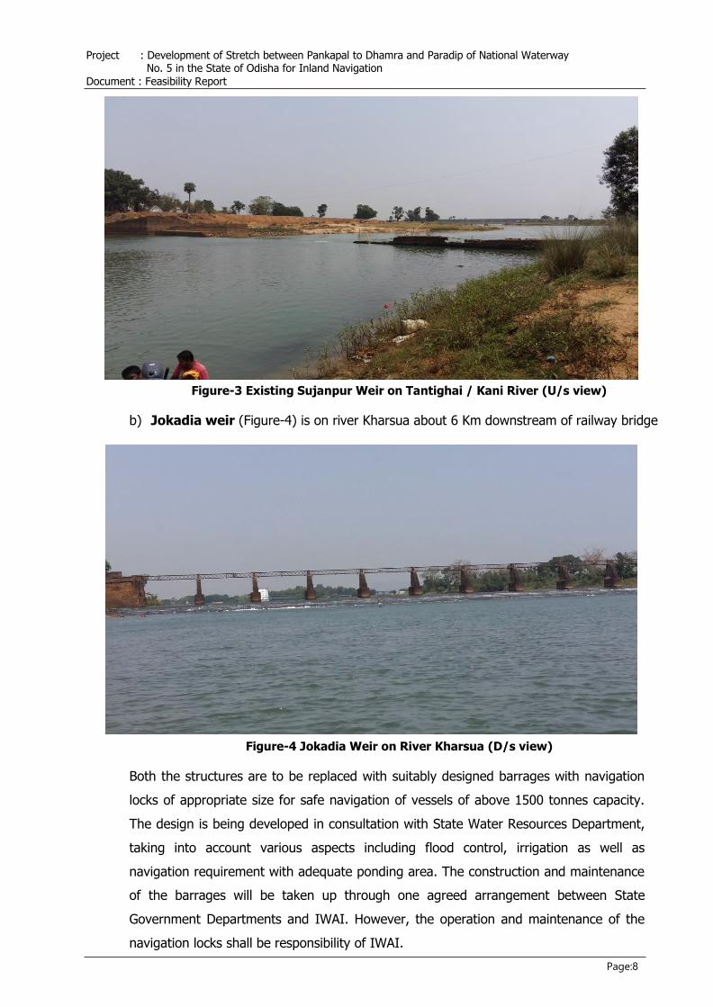
a) Sujanpur weir is on river Tantighai, a branch of Kharsua, about 400m downstream
of bifurcation from Kharsua at Sujanpur (Figure – 3).
Project : Development of Stretch between Pankapal to Dhamra and Paradip of National Waterway No. 5 in the State of Odisha for Inland Navigation
Document : Feasibility Report
Page:8
Figure-3 Existing Sujanpur Weir on Tantighai / Kani River (U/s view)
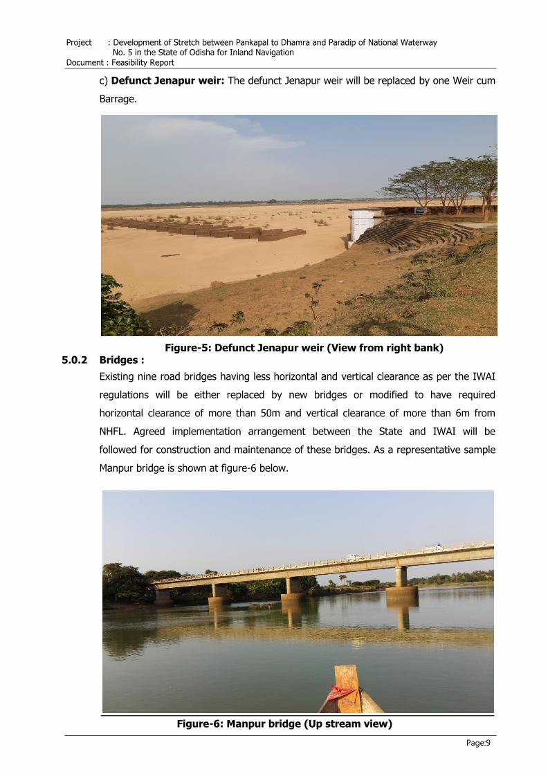
b) Jokadia weir (Figure-4) is on river Kharsua about 6 Km downstream of railway bridge
Figure-4 Jokadia Weir on River Kharsua (D/s view)
Both the structures are to be replaced with suitably designed barrages with navigation
locks of appropriate size for safe navigation of vessels of above 1500 tonnes capacity.
The design is being developed in consultation with State Water Resources Department,
taking into account various aspects including flood control, irrigation as well as
navigation requirement with adequate ponding area. The construction and maintenance
of the barrages will be taken up through one agreed arrangement between State
Government Departments and IWAI. However, the operation and maintenance of the
navigation locks shall be responsibility of IWAI.
Project : Development of Stretch between Pankapal to Dhamra and Paradip of National Waterway No. 5 in the State of Odisha for Inland Navigation
Document : Feasibility Report
Page:9
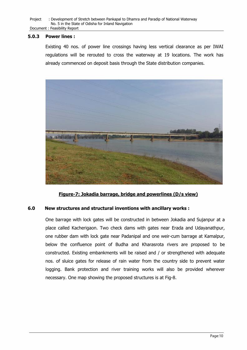
c) Defunct Jenapur weir: The defunct Jenapur weir will be replaced by one Weir cum
Barrage.
Figure-5: Defunct Jenapur weir (View from right bank) 5.0.2 Bridges :
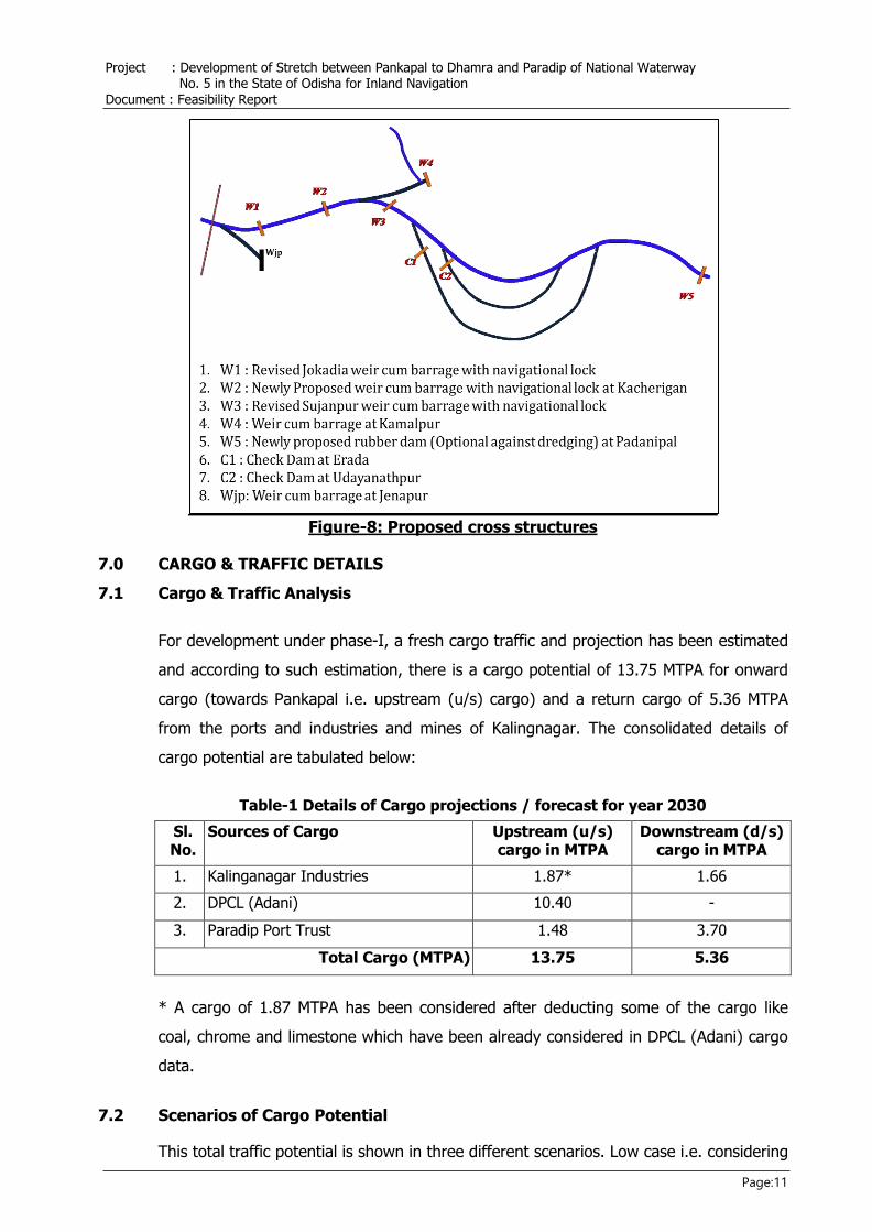
Existing nine road bridges having less horizontal and vertical clearance as per the IWAI
regulations will be either replaced by new bridges or modified to have required
horizontal clearance of more than 50m and vertical clearance of more than 6m from
NHFL. Agreed implementation arrangement between the State and IWAI will be
followed for construction and maintenance of these bridges. As a representative sample
Manpur bridge is shown at figure-6 below.
Figure-6: Manpur bridge (Up stream view)
Project : Development of Stretch between Pankapal to Dhamra and Paradip of National Waterway No. 5 in the State of Odisha for Inland Navigation
Document : Feasibility Report
Page:10
5.0.3 Power lines :
Existing 40 nos. of power line crossings having less vertical clearance as per IWAI
regulations will be rerouted to cross the waterway at 19 locations. The work has
already commenced on deposit basis through the State distribution companies.
Figure-7: Jokadia barrage, bridge and powerlines (D/s view)
6.0 New structures and structural inventions with ancillary works :
One barrage with lock gates will be constructed in between Jokadia and Sujanpur at a
place called Kacherigaon. Two check dams with gates near Erada and Udayanathpur,
one rubber dam with lock gate near Padanipal and one weir-cum barrage at Kamalpur,
below the confluence point of Budha and Kharasrota rivers are proposed to be
constructed. Existing embankments will be raised and / or strengthened with adequate
nos. of sluice gates for release of rain water from the country side to prevent water
logging. Bank protection and river training works will also be provided wherever
necessary. One map showing the proposed structures is at Fig-8.
Project : Development of Stretch between Pankapal to Dhamra and Paradip of National Waterway No. 5 in the State of Odisha for Inland Navigation
Document : Feasibility Report
Page:11
Figure-8: Proposed cross structures
7.0 CARGO & TRAFFIC DETAILS
7.1 Cargo & Traffic Analysis
For development under phase-I, a fresh cargo traffic and projection has been estimated
and according to such estimation, there is a cargo potential of 13.75 MTPA for onward
cargo (towards Pankapal i.e. upstream (u/s) cargo) and a return cargo of 5.36 MTPA
from the ports and industries and mines of Kalingnagar. The consolidated details of
cargo potential are tabulated below:
Table-1 Details of Cargo projections / forecast for year 2030
Sl. No.
Sources of Cargo Upstream (u/s) cargo in MTPA
Downstream (d/s) cargo in MTPA
1. Kalinganagar Industries 1.87* 1.66
2. DPCL (Adani) 10.40 -
3. Paradip Port Trust 1.48 3.70
Total Cargo (MTPA) 13.75 5.36
* A cargo of 1.87 MTPA has been considered after deducting some of the cargo like
coal, chrome and limestone which have been already considered in DPCL (Adani) cargo
data.
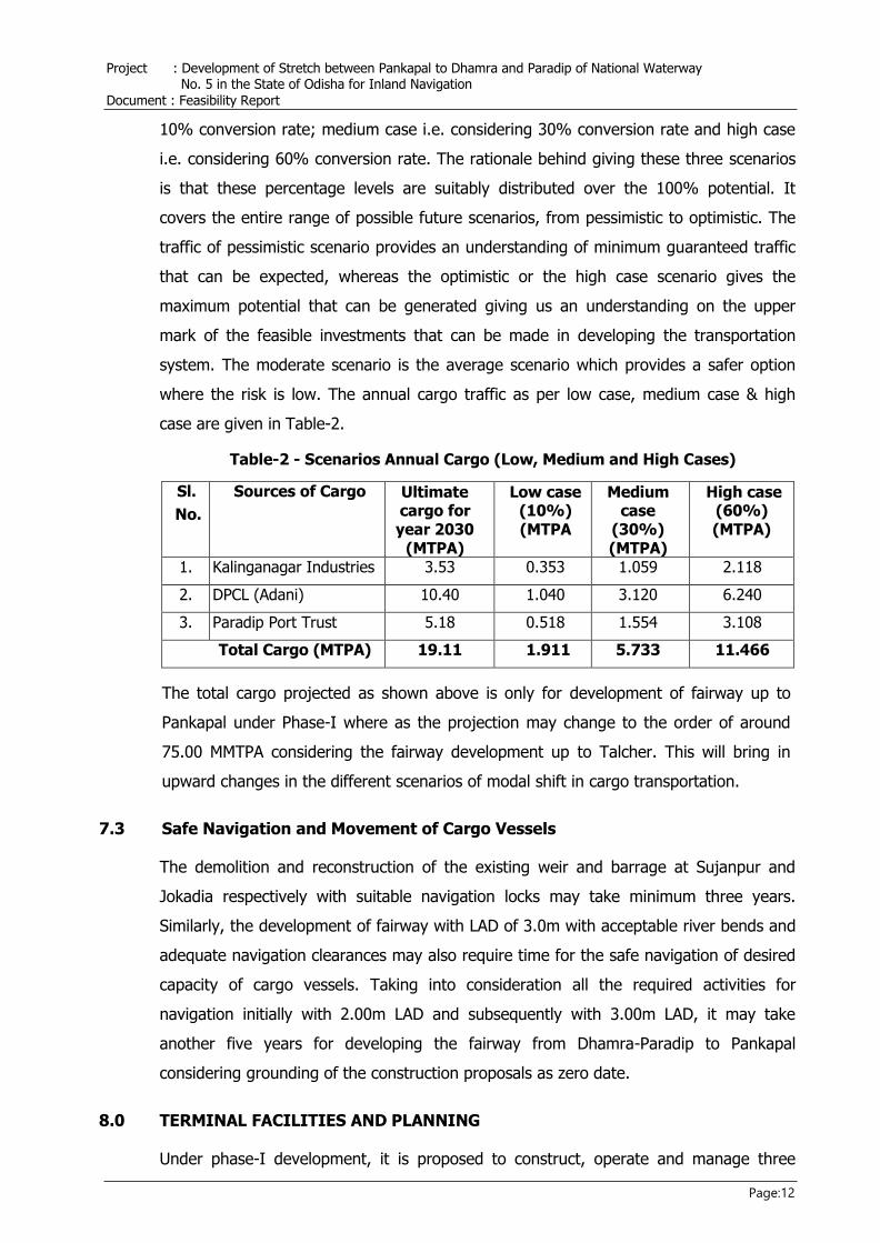
7.2 Scenarios of Cargo Potential
This total traffic potential is shown in three different scenarios. Low case i.e. considering
Project : Development of Stretch between Pankapal to Dhamra and Paradip of National Waterway No. 5 in the State of Odisha for Inland Navigation
Document : Feasibility Report
Page:12
10% conversion rate; medium case i.e. considering 30% conversion rate and high case
i.e. considering 60% conversion rate. The rationale behind giving these three scenarios
is that these percentage levels are suitably distributed over the 100% potential. It
covers the entire range of possible future scenarios, from pessimistic to optimistic. The
traffic of pessimistic scenario provides an understanding of minimum guaranteed traffic
that can be expected, whereas the optimistic or the high case scenario gives the
maximum potential that can be generated giving us an understanding on the upper
mark of the feasible investments that can be made in developing the transportation
system. The moderate scenario is the average scenario which provides a safer option
where the risk is low. The annual cargo traffic as per low case, medium case & high
case are given in Table-2.
Table-2 - Scenarios Annual Cargo (Low, Medium and High Cases)
Sl.
No.
Sources of Cargo Ultimate cargo for year 2030
(MTPA)
Low case (10%) (MTPA
Medium case
(30%) (MTPA)
High case (60%) (MTPA)
1. Kalinganagar Industries 3.53 0.353 1.059 2.118
2. DPCL (Adani) 10.40 1.040 3.120 6.240
3. Paradip Port Trust 5.18 0.518 1.554 3.108
Total Cargo (MTPA) 19.11 1.911 5.733 11.466
The total cargo projected as shown above is only for development of fairway up to
Pankapal under Phase-I where as the projection may change to the order of around
75.00 MMTPA considering the fairway development up to Talcher. This will bring in
upward changes in the different scenarios of modal shift in cargo transportation.
7.3 Safe Navigation and Movement of Cargo Vessels
The demolition and reconstruction of the existing weir and barrage at Sujanpur and
Jokadia respectively with suitable navigation locks may take minimum three years.
Similarly, the development of fairway with LAD of 3.0m with acceptable river bends and
adequate navigation clearances may also require time for the safe navigation of desired
capacity of cargo vessels. Taking into consideration all the required activities for
navigation initially with 2.00m LAD and subsequently with 3.00m LAD, it may take
another five years for developing the fairway from Dhamra-Paradip to Pankapal
considering grounding of the construction proposals as zero date.
8.0 TERMINAL FACILITIES AND PLANNING
Under phase-I development, it is proposed to construct, operate and manage three
Project : Development of Stretch between Pankapal to Dhamra and Paradip of National Waterway No. 5 in the State of Odisha for Inland Navigation
Document : Feasibility Report
Page:13
permanent terminal facilities with required jetties & cargo handling equipment for
catering to the projected cargo. Paradip Port and Dhamra Port Company Ltd. has
already agreed to dedicate one terminal each as captive facilities at their own premises.
The permanent terminal at Pankapal is going to be developed, operated and managed
jointly by one SPV, Inland Water Consortium of Odisha Limited (IWCOL) constituted for
the purpose with both the ports and State Govt. as constituent members. Land
measuring 115.41 acres has been identified in the village Pankapal for the permanent
terminal and steps for acquisition of land are being taken by the SPV, IWCOL.
9.0 DREDGING OPERATION
Dredging Quantity:
In order to develop the fair way with LAD of 3.0 m, maintenance dredging for a quantity
of 16 M cum is proposed to be undertaken during different period. The dredging
quantities have been computed for 2m depth initially and 3m depth subsequently with
respect to chart datum keeping the bottom base width as 45m.
Disposal of Dredged Material:
This dredged material can be used for infrastructure development activities i.e.
strengthening / extending the existing flood embankment on both sides of the river;
constructing new embankment; reclaiming land in low lying areas; in construction of
roads etc. The unused material can be dumped in adjoining government lands or land
under control of State Government, especially in the flood plains of the river with
appropriate arrangements to arrest back flow of the dredged material to the river
channel during floods. These dumping grounds should not cause obstruction to the flow
during flood. The dumping grounds above flood level can also be utilized as rescue
platform during floods.
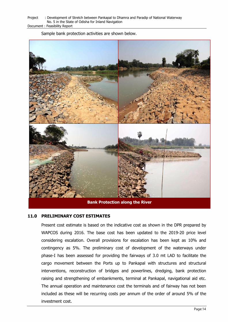
10.0 WIDENING OF WATERWAYS & BANK PROTECTION
The critical stretch with less width and river bends shall be widened to ensure safe
navigation. The stretch once widened may be protected with suitable bank protection
work. The bank protection of the waterways at present is being carried out by the State
Irrigation Department with respect to flood and embankment protection. However,
while the movement of the vessels will be increased, more bank protection in the
vulnerable stretch may be required & same to be carried out either by the State
Government on deposit basis or directly by IWAI through a standard operating
procedure.
Project : Development of Stretch between Pankapal to Dhamra and Paradip of National Waterway No. 5 in the State of Odisha for Inland Navigation
Document : Feasibility Report
Page:14
Bank Protection along the River
Sample bank protection activities are shown below.
11.0 PRELIMINARY COST ESTIMATES
Present cost estimate is based on the indicative cost as shown in the DPR prepared by
WAPCOS during 2016. The base cost has been updated to the 2019-20 price level
considering escalation. Overall provisions for escalation has been kept as 10% and
contingency as 5%. The preliminary cost of development of the waterways under
phase-I has been assessed for providing the fairways of 3.0 mt LAD to facilitate the
cargo movement between the Ports up to Pankapal with structures and structural
interventions, reconstruction of bridges and powerlines, dredging, bank protection
raising and strengthening of embankments, terminal at Pankapal, navigational aid etc.
The annual operation and maintenance cost the terminals and of fairway has not been
included as these will be recurring costs per annum of the order of around 5% of the
investment cost.
Project : Development of Stretch between Pankapal to Dhamra and Paradip of National Waterway No. 5 in the State of Odisha for Inland Navigation
Document : Feasibility Report
Page:15
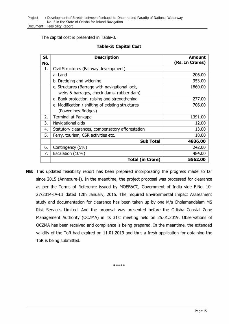
The capital cost is presented in Table-3.
Table-3: Capital Cost
Sl.
No.
Description Amount (Rs. In Crores)
1. Civil Structures (Fairway development)
a. Land 206.00
b. Dredging and widening 353.00
c. Structures (Barrage with navigational lock,
weirs & barrages, check dams, rubber dam)
1860.00
d. Bank protection, raising and strengthening 277.00
e. Modification / shifting of existing structures
(Powerlines-Bridges)
706.00
2. Terminal at Pankapal 1391.00
3. Navigational aids 12.00
4. Statutory clearances, compensatory afforestation 13.00
5. Ferry, tourism, CSR activities etc. 18.00
Sub Total 4836.00
6. Contingency (5%) 242.00
7. Escalation (10%) 484.00
Total (in Crore) 5562.00
NB: This updated feasibility report has been prepared incorporating the progress made so far
since 2015 (Annexure-I). In the meantime, the project proposal was processed for clearance
as per the Terms of Reference issued by MOEF&CC, Government of India vide F.No. 10-
27/2014-IA-III dated 12th January, 2015. The required Environmental Impact Assessment
study and documentation for clearance has been taken up by one M/s Cholamandalam MS
Risk Services Limited. And the proposal was presented before the Odisha Coastal Zone
Management Authority (OCZMA) in its 31st meeting held on 25.01.2019. Observations of
OCZMA has been received and compliance is being prepared. In the meantime, the extended
validity of the ToR had expired on 11.01.2019 and thus a fresh application for obtaining the
ToR is being submitted.
*****
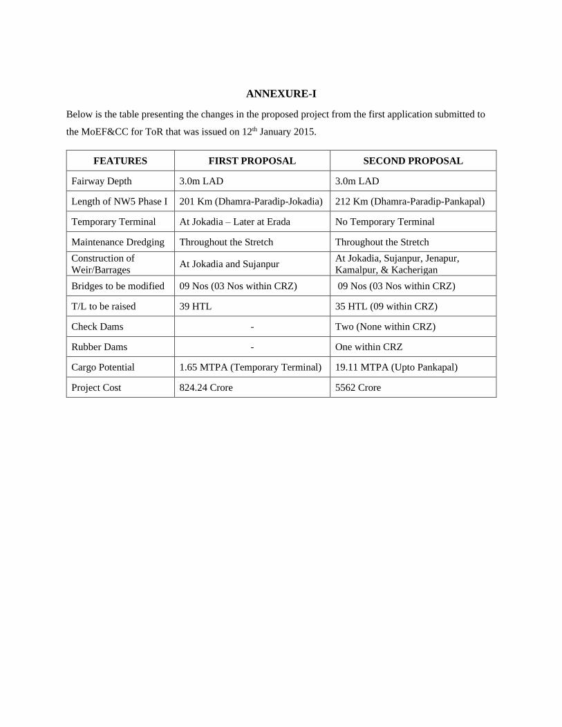
ANNEXURE-I
Below is the table presenting the changes in the proposed project from the first application submitted to
the MoEF&CC for ToR that was issued on 12th January 2015.
FEATURES FIRST PROPOSAL SECOND PROPOSAL
Fairway Depth 3.0m LAD 3.0m LAD
Length of NW5 Phase I 201 Km (Dhamra-Paradip-Jokadia) 212 Km (Dhamra-Paradip-Pankapal)
Temporary Terminal At Jokadia – Later at Erada No Temporary Terminal
Maintenance Dredging Throughout the Stretch Throughout the Stretch
Construction of
Weir/Barrages At Jokadia and Sujanpur
At Jokadia, Sujanpur, Jenapur,
Kamalpur, & Kacherigan
Bridges to be modified 09 Nos (03 Nos within CRZ) 09 Nos (03 Nos within CRZ)
T/L to be raised 39 HTL 35 HTL (09 within CRZ)
Check Dams - Two (None within CRZ)
Rubber Dams - One within CRZ
Cargo Potential 1.65 MTPA (Temporary Terminal) 19.11 MTPA (Upto Pankapal)
Project Cost 824.24 Crore 5562 Crore
Recommended