1999 Publ ic and Tr ibal Lands Inventor y
Statewide Profile1
Upland2 Area acresLand Area within State ....................................................... 43,270,277
Privately Owned3 ................................................................... 23,345,605
Publicly Owned4 ..................................................................... 17,247,392
Federal ......................................................................................... 12,885,415
State .................................................................................................. 3,729,613
Local .....................................................................................................632,364
Tribally Owned5 ......................................................................... 2,677,280
Public & Tribal Uplands:Reported Principal Use acres
Recreation/Habitat ............................................................. 10,076,356
Resource Production ........................................................... 5,544,126
Transportation/Utilities ....................................................... 1,060,616
Other Governmental Services ........................................... 752,831
Unknown Uses ........................................................................ 2,490,743
Public & Tribal Uplands:10 Largest Landowners acres
USDA Forest Service ............................................................. 9,104,373
WA Dept. of Natural Resources ..................................... 2,975,136
National Park Service ............................................................. 1,831,283
Yakama Nation ........................................................................... 1,152,539
Colville Confederated Tribes .............................................. 1,119,269
US Bureau of Reclamation .....................................................468,808
WA Dept. of Fish & Wildlife ...................................................461,036
US Dept. of the Army ................................................................404,313
USDOI Bureau of Land Mgmt .............................................. 392,583
US Richland Operations (Hanford) ...................................362,696
Percent Ownership by Landowner Type
Private54%
Local 1%
Federal 30%
State 9%
Tribe 6%
Notes1 Data were provided by landowners in response to a 1998 survey
by the Washington Interagency Committee for OutdoorRecreation. Other databases, such as those of the US Bureau ofIndian Affairs and county assessors, were used to supplementlandowner data.
2 “Uplands” means all lands not covered by water. The dataprovided here includes upland acres only.
3 “Privately owned” means uplands that are not owned by the publicor by tribes. No effort was made to ascertain the type ofownership or use of this land.
4 “Publicly owned” means uplands owned by federal, state, county, andmunicipal governments, and by major special purpose districts. Thiscategory also includes transportation right-of-ways.
5 “Tribally owned” means tribal trust lands or lands owned bytribal governments either within or outside of tribalreservation boundaries.

1999 Publ ic and Tr ibal Lands Inventor y
Adams County Profile1
Adams CountyPopulation: 16,428
Upland2 Area acresLand Area within County ................................................... 1,234,911
Privately Owned3 .................................................................... 1,143,665
Publicly Owned4 ............................................................................. 91,246
Federal ................................................................................................. 29,204
State ....................................................................................................... 60,580
Local ......................................................................................................... 1,462
Tribally Owned5 .......................................................................................... 0
Public & Tribal Uplands:Reported Principal Use acres
Recreation/Habitat ........................................................................ 13,339
Resource Production ................................................................... 60,622
Transportation/Utilities ............................................................... 14,407
Other Governmental Services .................................................. 1,919
Unknown Uses ....................................................................................... 959
Public & Tribal Uplands:10 Largest Landowners acres
WA Dept. of Natural Resources ........................................... 52,505
US Fish and Wildlife Service ................................................... 11,216
US Bureau of Reclamation .......................................................... 8,940
USDOI Bureau of Land Mgmt ................................................... 8,676
WA Dept. of Transportation ....................................................... 4,970
Washington State University ....................................................... 1,730
WA State Parks & Recreation ........................................................ 917
Adams County ........................................................................................ 767
WA Dept. of Fish & Wildlife ............................................................ 448
City of Othello ........................................................................................ 375
Percent Ownership by Landowner Type
Federal 2%
State 5%
Local 0%
Tribe 0%
Private93%
Notes1 Data were provided by landowners in response to a 1998 survey
by the Washington Interagency Committee for OutdoorRecreation. Other databases, such as those of the US Bureau ofIndian Affairs and county assessors, were used to supplementlandowner data.
2 “Uplands” means all lands not covered by water. The dataprovided here includes upland acres only.
3 “Privately owned” means uplands that are not owned by the publicor by tribes. No effort was made to ascertain the type ofownership or use of this land.
4 “Publicly owned” means uplands owned by federal, state, county, andmunicipal governments, and by major special purpose districts. Thiscategory also includes transportation right-of-ways.
5 “Tribally owned” means tribal trust lands or lands owned bytribal governments either within or outside of tribalreservation boundaries.
1999 Publ ic and Tr ibal Lands Inventor y
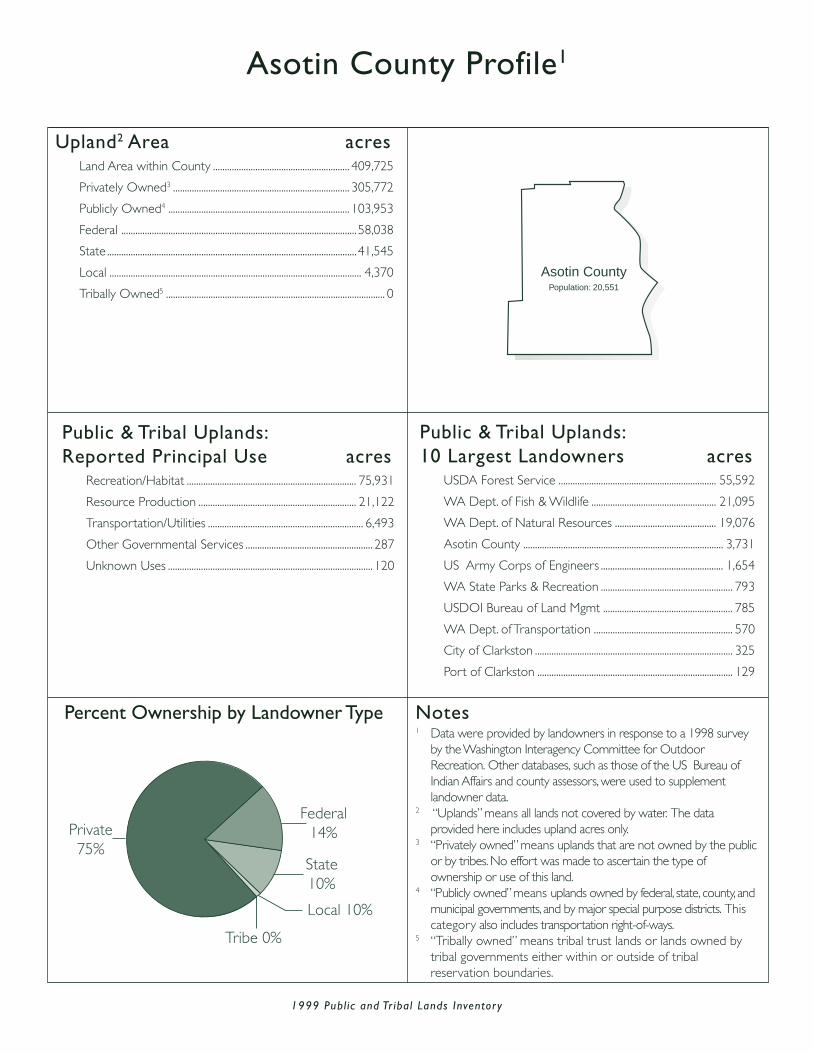
Asotin County Profile1
Upland2 Area acresLand Area within County .......................................................... 409,725
Privately Owned3 ........................................................................... 305,772
Publicly Owned4 ............................................................................. 103,953
Federal .................................................................................................... 58,038
State .......................................................................................................... 41,545
Local ........................................................................................................... 4,370
Tribally Owned5 ............................................................................................. 0
Public & Tribal Uplands:Reported Principal Use acres
Recreation/Habitat ........................................................................ 75,931
Resource Production ................................................................... 21,122
Transportation/Utilities .................................................................. 6,493
Other Governmental Services ...................................................... 287
Unknown Uses ....................................................................................... 120
Public & Tribal Uplands:10 Largest Landowners acres
USDA Forest Service ................................................................... 55,592
WA Dept. of Fish & Wildlife ..................................................... 21,095
WA Dept. of Natural Resources ........................................... 19,076
Asotin County ..................................................................................... 3,731
US Army Corps of Engineers .................................................... 1,654
WA State Parks & Recreation ........................................................ 793
USDOI Bureau of Land Mgmt ....................................................... 785
WA Dept. of Transportation ........................................................... 570
City of Clarkston .................................................................................... 325
Port of Clarkston ................................................................................... 129
Percent Ownership by Landowner Type
Federal14%Private
75%State10%
Local 10%
Tribe 0%
Asotin CountyPopulation: 20,551
Notes1 Data were provided by landowners in response to a 1998 survey
by the Washington Interagency Committee for OutdoorRecreation. Other databases, such as those of the US Bureau ofIndian Affairs and county assessors, were used to supplementlandowner data.
2 “Uplands” means all lands not covered by water. The dataprovided here includes upland acres only.
3 “Privately owned” means uplands that are not owned by the publicor by tribes. No effort was made to ascertain the type ofownership or use of this land.
4 “Publicly owned” means uplands owned by federal, state, county, andmunicipal governments, and by major special purpose districts. Thiscategory also includes transportation right-of-ways.
5 “Tribally owned” means tribal trust lands or lands owned bytribal governments either within or outside of tribalreservation boundaries.

1999 Publ ic and Tr ibal Lands Inventor y
Benton County Profile1
Federal 29%
State 5%
Local 2%
Tribe 0%
Private64%
Upland2 Area acresLand Area within County ...................................................... 1,126,068
Privately Owned3 ........................................................................... 731,909
Publicly Owned4 ............................................................................. 394,157
Federal ................................................................................................. 322,239
State ..........................................................................................................53,594
Local .........................................................................................................18,324
Tribally Owned5 ............................................................................................. 2
Public & Tribal Uplands:Reported Principal Use acres
Recreation/Habitat ..................................................................... 103,697
Resource Production ................................................................... 52,400
Transportation/Utilities ............................................................... 31,583
Other Governmental Services ............................................ 203,793
Unknown Uses ................................................................................... 2,686
Public & Tribal Uplands:10 Largest Landowners acres
US Richland Operations (Hanford) ................................... 275,409
WA Dept. of Natural Resources ............................................. 41,530
US Army Corps of Engineers ................................................... 18,164
US Fish and Wildlife Service ..................................................... 14,196
USDOI Bureau of Land Mgmt .................................................. 13,639
City of Richland .................................................................................... 8,437
WA Dept. of Fish & Wildlife ......................................................... 5,807
WA Dept. of Transportation ........................................................ 5,495
City of Kennewick .............................................................................. 2,388
Benton County ..................................................................................... 2,330
Percent Ownership by Landowner Type
BentonCounty
Population: 142,475
Notes1 Data were provided by landowners in response to a 1998 survey
by the Washington Interagency Committee for OutdoorRecreation. Other databases, such as those of the US Bureau ofIndian Affairs and county assessors, were used to supplementlandowner data.
2 “Uplands” means all lands not covered by water. The dataprovided here includes upland acres only.
3 “Privately owned” means uplands that are not owned by the publicor by tribes. No effort was made to ascertain the type ofownership or use of this land.
4 “Publicly owned” means uplands owned by federal, state, county, andmunicipal governments, and by major special purpose districts. Thiscategory also includes transportation right-of-ways.
5 “Tribally owned” means tribal trust lands or lands owned bytribal governments either within or outside of tribalreservation boundaries.

1999 Publ ic and Tr ibal Lands Inventor y
Chelan County Profile1
Upland2 Area acresLand Area within County ...................................................... 1,917,063
Privately Owned3 ........................................................................... 362,232
Publicly Owned4 ......................................................................... 1,554,831
Federal ............................................................................................. 1,480,885
State .......................................................................................................... 65,899
Local ........................................................................................................... 8,047
Tribally Owned5 ............................................................................................. 0
Public & Tribal Uplands:Reported Principal Use acres
Recreation/Habitat ................................................................. 1,176,469
Resource Production ................................................................ 365,377
Transportation/Utilities ............................................................... 12,024
Other Governmental Services ...................................................... 763
Unknown Uses ....................................................................................... 198
Public & Tribal Uplands:10 Largest Landowners acres
USDA Forest Service .............................................................. 1,326,851
National Park Service .................................................................. 126,076
WA Dept. of Natural Resources ............................................. 37,944
USDOI Bureau of Land Mgmt .................................................. 21,886
WA Dept. of Fish & Wildlife ....................................................... 21,009
US Fish and Wildlife Service ....................................................... 5,868
WA Dept. of Transportation ........................................................ 5,516
Chelan County Public Utility District ...................................... 5,200
WA State Parks & Recreation ..................................................... 1,265
City of Seattle ........................................................................................... 828
Percent Ownership by Landowner Type
Chelan CountyPopulation: 66,616
State 3%
Tribe 0%
Local 0%
Private 19%
Federal78%
Notes1 Data were provided by landowners in response to a 1998 survey
by the Washington Interagency Committee for OutdoorRecreation. Other databases, such as those of the US Bureau ofIndian Affairs and county assessors, were used to supplementlandowner data.
2 “Uplands” means all lands not covered by water. The dataprovided here includes upland acres only.
3 “Privately owned” means uplands that are not owned by the publicor by tribes. No effort was made to ascertain the type ofownership or use of this land.
4 “Publicly owned” means uplands owned by federal, state, county, andmunicipal governments, and by major special purpose districts. Thiscategory also includes transportation right-of-ways.
5 “Tribally owned” means tribal trust lands or lands owned bytribal governments either within or outside of tribalreservation boundaries.

1999 Publ ic and Tr ibal Lands Inventor y
Clallam County Profile1
Upland2 Area acresLand Area within County ...................................................... 1,129,706
Privately Owned3 ........................................................................... 400,665
Publicly Owned4 ............................................................................. 696,352
Federal ................................................................................................. 525,110
State ....................................................................................................... 166,613
Local ........................................................................................................... 4,629
Tribally Owned5 ................................................................................. 32,689
Public & Tribal Uplands:Reported Principal Use acres
Recreation/Habitat ..................................................................... 499,986
Resource Production ................................................................ 208,794
Transportation/Utilities ............................................................... 12,722
Other Governmental Services .................................................. 2,552
Unknown Uses ................................................................................... 4,987
Public & Tribal Uplands:10 Largest Landowners acres
National Park Service .................................................................. 328,783
USDA Forest Service .................................................................. 195,239
WA Dept. of Natural Resources .......................................... 158,575
Makah Tribe .......................................................................................... 30,142
WA State Parks & Recreation ..................................................... 4,325
WA Dept. of Transportation ........................................................ 3,135
Lower Elwha Klallam Tribe ............................................................. 1,494
Clallam County .................................................................................... 1,443
City of Forks .......................................................................................... 1,043
City of Port Angeles .............................................................................. 970
Percent Ownership by Landowner Type
State15%
Local 0%
Private35%
Tribe 3%
Federal47%
Clallam CountyPopulation: 64,525
Notes1 Data were provided by landowners in response to a 1998 survey
by the Washington Interagency Committee for OutdoorRecreation. Other databases, such as those of the US Bureau ofIndian Affairs and county assessors, were used to supplementlandowner data.
2 “Uplands” means all lands not covered by water. The dataprovided here includes upland acres only.
3 “Privately owned” means uplands that are not owned by the publicor by tribes. No effort was made to ascertain the type ofownership or use of this land.
4 “Publicly owned” means uplands owned by federal, state, county, andmunicipal governments, and by major special purpose districts. Thiscategory also includes transportation right-of-ways.
5 “Tribally owned” means tribal trust lands or lands owned bytribal governments either within or outside of tribalreservation boundaries.

1999 Publ ic and Tr ibal Lands Inventor y
Clark County Profile1
Upland2 Area acresLand Area within County .......................................................... 419,759
Privately Owned3 ........................................................................... 322,978
Publicly Owned4 ................................................................................ 96,781
Federal .................................................................................................... 13,300
State .......................................................................................................... 65,703
Local .........................................................................................................17,778
Tribally Owned5 ............................................................................................. 0
Public & Tribal Uplands:Reported Principal Use acres
Recreation/Habitat ........................................................................ 19,646
Resource Production ................................................................... 57,593
Transportation/Utilities ............................................................... 11,446
Other Governmental Services .................................................. 8,090
Unknown Uses ............................................................................................ 6
Public & Tribal Uplands:10 Largest Landowners acres
WA Dept. of Natural Resources ............................................. 58,475
US Fish and Wildlife Service ....................................................... 6,173
Clark County ......................................................................................... 5,712
City of Vancouver ................................................................................ 5,451
WA Dept. of Transportation ........................................................ 3,459
US Dept. of Army ............................................................................. 3,021
City of Camas ....................................................................................... 2,439
WA Dept. of Fish & Wildlife ......................................................... 2,138
USDA Forest Service ....................................................................... 1,981
Bonneville Power Administration ............................................... 1,664
Percent Ownership by Landowner Type
Clark CountyPopulation:
345,238
Federal 3%
State 16%
Local 4%
Tribe 0%
Private77%
Notes1 Data were provided by landowners in response to a 1998 survey
by the Washington Interagency Committee for OutdoorRecreation. Other databases, such as those of the US Bureau ofIndian Affairs and county assessors, were used to supplementlandowner data.
2 “Uplands” means all lands not covered by water. The dataprovided here includes upland acres only.
3 “Privately owned” means uplands that are not owned by the publicor by tribes. No effort was made to ascertain the type ofownership or use of this land.
4 “Publicly owned” means uplands owned by federal, state, county, andmunicipal governments, and by major special purpose districts. Thiscategory also includes transportation right-of-ways.
5 “Tribally owned” means tribal trust lands or lands owned bytribal governments either within or outside of tribalreservation boundaries.
1999 Publ ic and Tr ibal Lands Inventor y
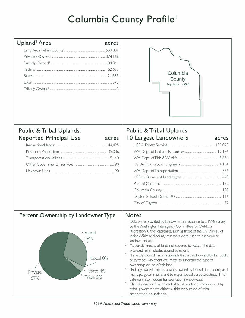
Columbia County Profile1
Upland2 Area acresLand Area within County .......................................................... 559,007
Privately Owned3 ........................................................................... 374,166
Publicly Owned4 ............................................................................. 184,841
Federal ................................................................................................. 162,683
State ..........................................................................................................21,585
Local ............................................................................................................... 573
Tribally Owned5 ............................................................................................. 0
Public & Tribal Uplands:Reported Principal Use acres
Recreation/Habitat ..................................................................... 144,425
Resource Production ................................................................... 35,006
Transportation/Utilities .................................................................. 5,140
Other Governmental Services .........................................................80
Unknown Uses ....................................................................................... 190
Public & Tribal Uplands:10 Largest Landowners acres
USDA Forest Service .................................................................. 158,028
WA Dept. of Natural Resources ............................................. 12,134
WA Dept. of Fish & Wildlife ......................................................... 8,834
US Army Corps of Engineers ..................................................... 4,194
WA Dept. of Transportation ............................................................ 576
USDOI Bureau of Land Mgmt ........................................................ 440
Port of Columbia .................................................................................... 152
Columbia County ................................................................................... 150
Dayton School District #2 ................................................................ 116
City of Dayton ............................................................................................. 77
Percent Ownership by Landowner Type
Federal29%
State 4%
Local 0%
Tribe 0%Private67%
ColumbiaCounty
Population: 4,064
Notes1 Data were provided by landowners in response to a 1998 survey
by the Washington Interagency Committee for OutdoorRecreation. Other databases, such as those of the US Bureau ofIndian Affairs and county assessors, were used to supplementlandowner data.
2 “Uplands” means all lands not covered by water. The dataprovided here includes upland acres only.
3 “Privately owned” means uplands that are not owned by the publicor by tribes. No effort was made to ascertain the type ofownership or use of this land.
4 “Publicly owned” means uplands owned by federal, state, county, andmunicipal governments, and by major special purpose districts. Thiscategory also includes transportation right-of-ways.
5 “Tribally owned” means tribal trust lands or lands owned bytribal governments either within or outside of tribalreservation boundaries.

1999 Publ ic and Tr ibal Lands Inventor y
Cowlitz County Profile1
Upland2 Area acresLand Area within County .......................................................... 746,290
Privately Owned3 ........................................................................... 612,093
Publicly Owned4 ............................................................................. 134,197
Federal .................................................................................................... 35,908
State .......................................................................................................... 92,723
Local ........................................................................................................... 5,566
Tribally Owned5 ............................................................................................. 0
Public & Tribal Uplands:Reported Principal Use acres
Recreation/Habitat .................................................................. 36,944
Resource Production ............................................................. 82,550
Transpor tation/Utilities .......................................................... 6,810
Other Governmental Services ......................................... 1,400
Unknown Uses ............................................................................... 6,493
Public & Tribal Uplands:10 Largest Landowners acres
WA Dept. of Natural Resources ................................... 83,342
USDA Forest Service .............................................................. 35,410
WA Dept. of Transpor tation ................................................ 4,532
WA Dept. of Fish & Wildlife ................................................. 4,331
Cowlitz County ............................................................................... 1,673
Por t of Longview ................................................................................ 687
City of Kelso ........................................................................................... 643
Por t of Kalama ...................................................................................... 602
City of Longview ................................................................................. 541
WA State Parks & Recreation .................................................. 475
Percent Ownership by Landowner Type
Cowlitz CountyPopulation: 92,948
Federal 5%
Local 1%
State12%
Tribe 0%
Private82%
Notes1 Data were provided by landowners in response to a 1998 survey
by the Washington Interagency Committee for OutdoorRecreation. Other databases, such as those of the US Bureau ofIndian Affairs and county assessors, were used to supplementlandowner data.
2 “Uplands” means all lands not covered by water. The dataprovided here includes upland acres only.
3 “Privately owned” means uplands that are not owned by the publicor by tribes. No effort was made to ascertain the type ofownership or use of this land.
4 “Publicly owned” means uplands owned by federal, state, county, andmunicipal governments, and by major special purpose districts. Thiscategory also includes transportation right-of-ways.
5 “Tribally owned” means tribal trust lands or lands owned bytribal governments either within or outside of tribalreservation boundaries.

1999 Publ ic and Tr ibal Lands Inventor y
Douglas County Profile1
Upland2 Area acresLand Area within County .............................................. 1,183,431
Privately Owned3 ................................................................. 1,013,630
Publicly Owned4 ....................................................................... 169,801
Federal ................................................................................................. 49,319
State ................................................................................................... 116,365
Local ......................................................................................................... 4,117
Tribally Owned5 ......................................................................................... 0
Public & Tribal Uplands:Reported Principal Use acres
Recreation/Habitat .................................................................. 10,125
Resource Production .......................................................... 146,864
Transpor tation/Utilities ....................................................... 11,433
Other Governmental Ser vices ............................................. 519
Unknown Uses ................................................................................... 860
Public & Tribal Uplands:10 Largest Landowners acres
WA Dept. of Natural Resources ................................ 104,792
USDOI Bureau of Land Mgmt ......................................... 44,713
WA Dept. of Fish & Wildlife ................................................. 7,080
WA Dept. of Transpor tation ................................................ 4,091
US Bureau of Reclamation ..................................................... 3,334
Douglas County Public Utility Dist. ................................ 1,397
US Army Corps of Engineers .............................................. 1,072
Douglas County ................................................................................... 527
Chelan County Public Utility District ................................ 500
Town of Waterville ............................................................................ 350
Percent Ownership by Landowner Type
Federal11%
State 5%Local 1%
Tribe 0%
Private83%
DouglasCounty
Population: 32,603
Notes1 Data were provided by landowners in response to a 1998 survey
by the Washington Interagency Committee for OutdoorRecreation. Other databases, such as those of the US Bureau ofIndian Affairs and county assessors, were used to supplementlandowner data.
2 “Uplands” means all lands not covered by water. The dataprovided here includes upland acres only.
3 “Privately owned” means uplands that are not owned by the publicor by tribes. No effort was made to ascertain the type ofownership or use of this land.
4 “Publicly owned” means uplands owned by federal, state, county, andmunicipal governments, and by major special purpose districts. Thiscategory also includes transportation right-of-ways.
5 “Tribally owned” means tribal trust lands or lands owned bytribal governments either within or outside of tribalreservation boundaries.

1999 Publ ic and Tr ibal Lands Inventor y
Ferry County Profile1
Upland2 Area acresLand Area within County ...................................................... 1,445,962
Privately Owned3 ........................................................................... 233,845
Publicly Owned4 ............................................................................. 562,309
Federal ................................................................................................. 521,624
State .......................................................................................................... 38,377
Local ........................................................................................................... 2,308
Tribally Owned5 .............................................................................. 649,808
Public & Tribal Uplands:Reported Principal Use acres
Recreation/Habitat ..................................................................... 190,684
Resource Production ................................................................ 327,960
Transportation/Utilities ............................................................... 42,793
Other Governmental Services ...................................................... 865
Unknown Uses ............................................................................. 649,815
Public & Tribal Uplands:10 Largest Landowners acres
Colville Confederated Tribes ................................................... 649,808
USDA Forest Service .................................................................. 481,610
US Bureau of Reclamation ......................................................... 29,635
WA Dept. of Natural Resources ............................................. 29,013
USDOI Bureau of Land Mgmt .................................................... 9,796
WA Dept. of Fish & Wildlife ......................................................... 6,902
WA Dept. of Transportation ........................................................ 2,201
City of Seattle ....................................................................................... 1,669
US Fish and Wildlife Service ........................................................... 560
Ferry County ............................................................................................. 505
Percent Ownership by Landowner Type
Ferry CountyPopulation:
7,260
Tribe 45%State 3%
Local 0%
Private 16%
Federal36%
Notes1 Data were provided by landowners in response to a 1998 survey
by the Washington Interagency Committee for OutdoorRecreation. Other databases, such as those of the US Bureau ofIndian Affairs and county assessors, were used to supplementlandowner data.
2 “Uplands” means all lands not covered by water. The dataprovided here includes upland acres only.
3 “Privately owned” means uplands that are not owned by the publicor by tribes. No effort was made to ascertain the type ofownership or use of this land.
4 “Publicly owned” means uplands owned by federal, state, county, andmunicipal governments, and by major special purpose districts. Thiscategory also includes transportation right-of-ways.
5 “Tribally owned” means tribal trust lands or lands owned bytribal governments either within or outside of tribalreservation boundaries.

1999 Publ ic and Tr ibal Lands Inventor y
Franklin County Profile1
Upland2 Area acresLand Area within County .......................................................... 809,476
Privately Owned3 ........................................................................... 674,084
Publicly Owned4 ............................................................................. 135,392
Federal .................................................................................................... 89,943
State ..........................................................................................................38,691
Local ........................................................................................................... 6,758
Tribally Owned5 ............................................................................................. 0
Public & Tribal Uplands:Reported Principal Use acres
Recreation/Habitat ........................................................................ 33,845
Resource Production ................................................................... 45,858
Transportation/Utilities ............................................................... 54,138
Other Governmental Services .................................................. 1,362
Unknown Uses ....................................................................................... 189
Public & Tribal Uplands:10 Largest Landowners acres
US Bureau of Reclamation ......................................................... 37,088
WA Dept. of Natural Resources ............................................. 28,927
USDOI Bureau of Land Mgmt .................................................. 22,340
US Richland Operations (Hanford) ...................................... 21,287
US Army Corps of Engineers ..................................................... 8,884
WA Dept. of Transportation ........................................................ 4,912
City of Pasco .......................................................................................... 3,222
Port of Pasco ......................................................................................... 3,105
WA State Parks & Recreation ..................................................... 2,769
WA Dept. of Fish & Wildlife ......................................................... 1,934
Percent Ownership by Landowner Type
Federal11%
State 5%Local 1%
Tribe 0%
Private83%
Franklin CountyPopulation: 49,347
Notes1 Data were provided by landowners in response to a 1998 survey
by the Washington Interagency Committee for OutdoorRecreation. Other databases, such as those of the US Bureau ofIndian Affairs and county assessors, were used to supplementlandowner data.
2 “Uplands” means all lands not covered by water. The dataprovided here includes upland acres only.
3 “Privately owned” means uplands that are not owned by the publicor by tribes. No effort was made to ascertain the type ofownership or use of this land.
4 “Publicly owned” means uplands owned by federal, state, county, andmunicipal governments, and by major special purpose districts. Thiscategory also includes transportation right-of-ways.
5 “Tribally owned” means tribal trust lands or lands owned bytribal governments either within or outside of tribalreservation boundaries.
1999 Publ ic and Tr ibal Lands Inventor y
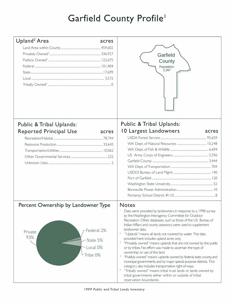
Garfield County Profile1
Federal 2%
State 5%
Local 0%
Tribe 0%
Private93%
Upland2 Area acresLand Area within County .......................................................... 459,602
Privately Owned3 ........................................................................... 336,927
Publicly Owned4 ............................................................................. 122,675
Federal ................................................................................................. 101,404
State .......................................................................................................... 17,699
Local ........................................................................................................... 3,572
Tribally Owned5 ............................................................................................. 0
Public & Tribal Uplands:Reported Principal Use acres
Recreation/Habitat ........................................................................ 78,744
Resource Production ................................................................... 33,645
Transportation/Utilities ............................................................... 10,062
Other Governmental Services ...................................................... 222
Unknown Uses ............................................................................................ 2
Public & Tribal Uplands:10 Largest Landowners acres
USDA Forest Service ................................................................... 95,659
WA Dept. of Natural Resources ........................................... 10,248
WA Dept. of Fish & Wildlife ........................................................ 6,694
US Army Corps of Engineers .................................................... 5,596
Garfield County .................................................................................. 3,444
WA Dept. of Transportation ........................................................... 704
USDOI Bureau of Land Mgmt ....................................................... 140
Port of Garfield ....................................................................................... 120
Washington State University .............................................................. 52
Bonneville Power Administration ..................................................... 10
Pomeroy School District #110 ............................................................ 8
Percent Ownership by Landowner Type
Garfield County Population:
2,397
Notes1 Data were provided by landowners in response to a 1998 survey
by the Washington Interagency Committee for OutdoorRecreation. Other databases, such as those of the US Bureau ofIndian Affairs and county assessors, were used to supplementlandowner data.
2 “Uplands” means all lands not covered by water. The dataprovided here includes upland acres only.
3 “Privately owned” means uplands that are not owned by the publicor by tribes. No effort was made to ascertain the type ofownership or use of this land.
4 “Publicly owned” means uplands owned by federal, state, county, andmunicipal governments, and by major special purpose districts. Thiscategory also includes transportation right-of-ways.
5 “Tribally owned” means tribal trust lands or lands owned bytribal governments either within or outside of tribalreservation boundaries.

1999 Publ ic and Tr ibal Lands Inventor y
Grant County Profile1
Upland2 Area acresLand Area within County ...................................................... 1,786,405
Privately Owned3 ....................................................................... 1,138,450
Publicly Owned4 ............................................................................. 647,955
Federal ................................................................................................. 483,103
State ....................................................................................................... 149,761
Local .........................................................................................................15,091
Tribally Owned5 ............................................................................................. 0
Public & Tribal Uplands:Reported Principal Use acres
Recreation/Habitat ..................................................................... 191,051
Resource Production ................................................................ 119,297
Transportation/Utilities ............................................................ 329,718
Other Governmental Services .................................................. 2,880
Unknown Uses ................................................................................... 5,009
Public & Tribal Uplands:10 Largest Landowners acres
US Bureau of Reclamation ...................................................... 312,284
WA Dept. of Natural Resources ............................................. 95,763
US Richland Operations (Hanford) ...................................... 65,637
US Fish and Wildlife Service ..................................................... 54,084
USDOI Bureau of Land Mgmt .................................................. 51,030
WA Dept. of Fish & Wildlife ....................................................... 39,168
WA Dept. of Transportation ........................................................ 8,640
WA State Parks & Recreation ..................................................... 5,825
Port of Moses Lake ............................................................................ 4,667
Grant County Public Utility Dist. #2 ....................................... 4,187
Percent Ownership by Landowner Type
Federal27%
State 8%
Local 1%
Tribe 0%
Private64%
GrantCounty
Population: 74,698
Notes1 Data were provided by landowners in response to a 1998 survey
by the Washington Interagency Committee for OutdoorRecreation. Other databases, such as those of the US Bureau ofIndian Affairs and county assessors, were used to supplementlandowner data.
2 “Uplands” means all lands not covered by water. The dataprovided here includes upland acres only.
3 “Privately owned” means uplands that are not owned by the publicor by tribes. No effort was made to ascertain the type ofownership or use of this land.
4 “Publicly owned” means uplands owned by federal, state, county, andmunicipal governments, and by major special purpose districts. Thiscategory also includes transportation right-of-ways.
5 “Tribally owned” means tribal trust lands or lands owned bytribal governments either within or outside of tribalreservation boundaries.
1999 Publ ic and Tr ibal Lands Inventor y
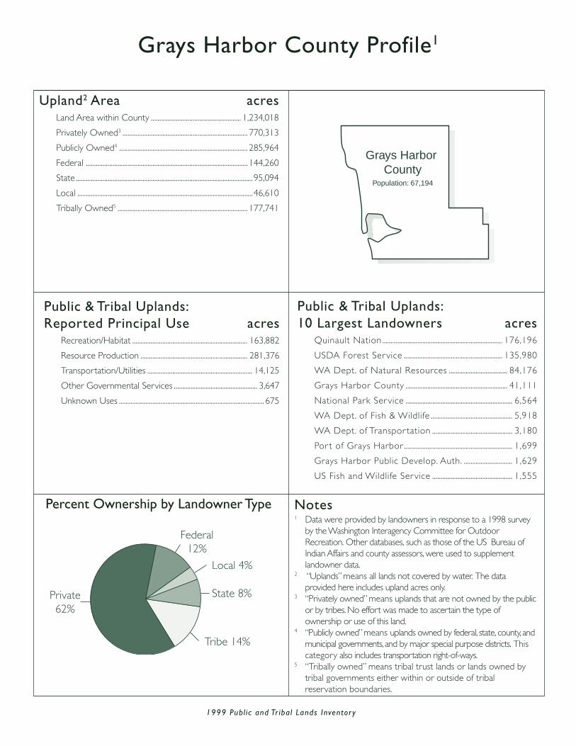
Grays Harbor County Profile1
Upland2 Area acresLand Area within County ...................................................... 1,234,018
Privately Owned3 ........................................................................... 770,313
Publicly Owned4 ............................................................................. 285,964
Federal ................................................................................................. 144,260
State .......................................................................................................... 95,094
Local .........................................................................................................46,610
Tribally Owned5 .............................................................................. 177,741
Public & Tribal Uplands:Reported Principal Use acres
Recreation/Habitat ..................................................................... 163,882
Resource Production ................................................................ 281,376
Transportation/Utilities ............................................................... 14,125
Other Governmental Services .................................................. 3,647
Unknown Uses ....................................................................................... 675
Public & Tribal Uplands:10 Largest Landowners acres
Quinault Nation ........................................................................ 176,196
USDA Forest Service ........................................................... 135,980
WA Dept. of Natural Resources ................................... 84,176
Grays Harbor County ............................................................. 41,111
National Park Service ................................................................ 6,564
WA Dept. of Fish & Wildlife ................................................. 5,918
WA Dept. of Transpor tation ................................................ 3,180
Por t of Grays Harbor ................................................................. 1,699
Grays Harbor Public Develop. Auth. ............................. 1,629
US Fish and Wildlife Service ................................................ 1,555
Percent Ownership by Landowner Type
State 8%
Federal12%
Local 4%
Private62%
Tribe 14%
Grays Harbor County
Population: 67,194
Notes1 Data were provided by landowners in response to a 1998 survey
by the Washington Interagency Committee for OutdoorRecreation. Other databases, such as those of the US Bureau ofIndian Affairs and county assessors, were used to supplementlandowner data.
2 “Uplands” means all lands not covered by water. The dataprovided here includes upland acres only.
3 “Privately owned” means uplands that are not owned by the publicor by tribes. No effort was made to ascertain the type ofownership or use of this land.
4 “Publicly owned” means uplands owned by federal, state, county, andmunicipal governments, and by major special purpose districts. Thiscategory also includes transportation right-of-ways.
5 “Tribally owned” means tribal trust lands or lands owned bytribal governments either within or outside of tribalreservation boundaries.
1999 Publ ic and Tr ibal Lands Inventor y
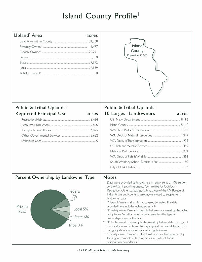
Island County Profile1
Upland2 Area acresLand Area within County .......................................................... 134,268
Privately Owned3 ........................................................................... 111,477
Publicly Owned4 ................................................................................ 22,791
Federal ...................................................................................................... 8,980
State ............................................................................................................ 7,672
Local ........................................................................................................... 6,139
Tribally Owned5 ............................................................................................. 0
Public & Tribal Uplands:Reported Principal Use acres
Recreation/Habitat ........................................................................... 6,464
Resource Production ...................................................................... 2,820
Transportation/Utilities .................................................................. 4,875
Other Governmental Services .................................................. 8,632
Unknown Uses ............................................................................................ 0
Public & Tribal Uplands:10 Largest Landowners acres
US Navy Department .................................................................... 8,186
Island County ........................................................................................ 5,110
WA State Parks & Recreation ..................................................... 4,546
WA Dept. of Natural Resources ............................................... 1,914
WA Dept. of Transportation ............................................................ 939
US Fish and Wildlife Service ........................................................... 449
National Park Service ........................................................................... 294
WA Dept. of Fish & Wildlife ............................................................. 251
South Whidbey School District #206 ........................................ 192
City of Oak Harbor ............................................................................... 176
Percent Ownership by Landowner Type
Federal7%
State 6%
Local 5%
Tribe 0%
Private82%
IslandCounty
Population: 71,558
Notes1 Data were provided by landowners in response to a 1998 survey
by the Washington Interagency Committee for OutdoorRecreation. Other databases, such as those of the US Bureau ofIndian Affairs and county assessors, were used to supplementlandowner data.
2 “Uplands” means all lands not covered by water. The dataprovided here includes upland acres only.
3 “Privately owned” means uplands that are not owned by the publicor by tribes. No effort was made to ascertain the type ofownership or use of this land.
4 “Publicly owned” means uplands owned by federal, state, county, andmunicipal governments, and by major special purpose districts. Thiscategory also includes transportation right-of-ways.
5 “Tribally owned” means tribal trust lands or lands owned bytribal governments either within or outside of tribalreservation boundaries.

1999 Publ ic and Tr ibal Lands Inventor y
Jefferson County Profile1
Upland2 Area acresLand Area within County ...................................................... 1,163,069
Privately Owned3 ........................................................................... 245,245
Publicly Owned4 ............................................................................. 912,066
Federal ................................................................................................. 707,506
State ....................................................................................................... 202,945
Local ........................................................................................................... 1,615
Tribally Owned5 ................................................................................... 5,758
Public & Tribal Uplands:Reported Principal Use acres
Recreation/Habitat ..................................................................... 698,774
Resource Production ................................................................ 206,232
Transportation/Utilities .................................................................. 6,144
Other Governmental Services .................................................. 4,110
Unknown Uses ................................................................................... 2,564
Public & Tribal Uplands:10 Largest Landowners acres
National Park Service .................................................................540,169
WA Dept. of Natural Resources .........................................198,437
USDA Forest Service .................................................................163,413
Quinault Nation .................................................................................. 5,292
US Dept. of Navy ............................................................................. 3,512
WA State Parks & Recreation .................................................... 2,677
WA Dept. of Transportation ....................................................... 1,548
Jefferson County ................................................................................ 1,178
Hoh Tribe .................................................................................................... 466
Port of Port Townsend ....................................................................... 408
Percent Ownership by Landowner Type
State 17%
Tribe 0%
Local 0%
Federal62%
Private 21%
Jefferson CountyPopulation: 25,953
Notes1 Data were provided by landowners in response to a 1998 survey
by the Washington Interagency Committee for OutdoorRecreation. Other databases, such as those of the US Bureau ofIndian Affairs and county assessors, were used to supplementlandowner data.
2 “Uplands” means all lands not covered by water. The dataprovided here includes upland acres only.
3 “Privately owned” means uplands that are not owned by the publicor by tribes. No effort was made to ascertain the type ofownership or use of this land.
4 “Publicly owned” means uplands owned by federal, state, county, andmunicipal governments, and by major special purpose districts. Thiscategory also includes transportation right-of-ways.
5 “Tribally owned” means tribal trust lands or lands owned bytribal governments either within or outside of tribalreservation boundaries.

1999 Publ ic and Tr ibal Lands Inventor y
King County Profile1
Upland2 Area acresLand Area within County ................................................... 1,401,050
Privately Owned3 ........................................................................ 757,292
Publicly Owned4 .......................................................................... 642,460
Federal .............................................................................................. 348,907
State .................................................................................................... 109,571
Local ................................................................................................... 183,982
Tribally Owned5 ................................................................................. 1,298
Public & Tribal Uplands:Reported Principal Use acres
Recreation/Habitat ..................................................................... 424,963
Resource Production ................................................................ 143,446
Transportation/Utilities ............................................................... 55,001
Other Governmental Services ............................................... 12,474
Unknown Uses ................................................................................... 7,874
Public & Tribal Uplands:10 Largest Landowners acres
USDA Forest Service .................................................................. 345,350
City of Seattle .................................................................................. 112,311
WA Dept. of Natural Resources ............................................. 81,539
King County ......................................................................................... 24,348
WA Dept. of Transportation ...................................................... 16,025
City of Tacoma .................................................................................... 14,173
WA State Parks & Recreation ..................................................... 9,137
City of Kent ............................................................................................ 3,771
City of Bellevue .................................................................................... 3,208
City of Renton ...................................................................................... 2,582
Percent Ownership by Landowner Type
Federal25%
State 8%
Local 13%
Tribe 0%Private54%
King CountyPopulation: 1,737,034
Notes1 Data were provided by landowners in response to a 1998 survey
by the Washington Interagency Committee for OutdoorRecreation. Other databases, such as those of the US Bureau ofIndian Affairs and county assessors, were used to supplementlandowner data.
2 “Uplands” means all lands not covered by water. The dataprovided here includes upland acres only.
3 “Privately owned” means uplands that are not owned by the publicor by tribes. No effort was made to ascertain the type ofownership or use of this land.
4 “Publicly owned” means uplands owned by federal, state, county, andmunicipal governments, and by major special purpose districts. Thiscategory also includes transportation right-of-ways.
5 “Tribally owned” means tribal trust lands or lands owned bytribal governments either within or outside of tribalreservation boundaries.

1999 Publ ic and Tr ibal Lands Inventor y
Kitsap County Profile1
Upland2 Area acresLand Area within County .......................................................... 254,652
Privately Owned3 ........................................................................... 203,425
Publicly Owned4 ................................................................................ 46,778
Federal ...................................................................................................... 9,201
State .......................................................................................................... 18,431
Local .........................................................................................................19,146
Tribally Owned5 ................................................................................... 4,449
Public & Tribal Uplands:Reported Principal Use acres
Recreation/Habitat ........................................................................... 7,610
Resource Production ................................................................... 24,804
Transportation/Utilities .................................................................. 5,670
Other Governmental Services ............................................... 13,077
Unknown Uses ..........................................................................................66
Public & Tribal Uplands:10 Largest Landowners acres
WA Dept. of Natural Resources ........................................... 14,860
City of Bremerton .......................................................................... 10,983
US Dept. of Navy ............................................................................. 9,103
Suquamish Tribe .................................................................................. 3,107
Kitsap County ....................................................................................... 2,945
Port of Bremerton ............................................................................ 1,787
WA Dept. of Transportation ....................................................... 1,629
Port Gamble Klallam Tribe ............................................................ 1,341
WA State Parks & Recreation .................................................... 1,201
Bainbridge Island Park District ........................................................ 890
Percent Ownership by Landowner Type
Local 13%
State 8%
Federal 4%
Private79%
Tribe 0%
Kitsap CountyPopulation:
231,969
Notes1 Data were provided by landowners in response to a 1998 survey
by the Washington Interagency Committee for OutdoorRecreation. Other databases, such as those of the US Bureau ofIndian Affairs and county assessors, were used to supplementlandowner data.
2 “Uplands” means all lands not covered by water. The dataprovided here includes upland acres only.
3 “Privately owned” means uplands that are not owned by the publicor by tribes. No effort was made to ascertain the type ofownership or use of this land.
4 “Publicly owned” means uplands owned by federal, state, county, andmunicipal governments, and by major special purpose districts. Thiscategory also includes transportation right-of-ways.
5 “Tribally owned” means tribal trust lands or lands owned bytribal governments either within or outside of tribalreservation boundaries.

1999 Publ ic and Tr ibal Lands Inventor y
Kittitas County Profile1
Upland2 Area acresLand Area within County ..................................................... 1,493,006
Privately Owned3 ..........................................................................582,755
Publicly Owned4 ............................................................................910,011
Federal ................................................................................................612,484
State ......................................................................................................292,291
Local .......................................................................................................... 5,236
Tribally Owned5 ...................................................................................... 240
Public & Tribal Uplands:Reported Principal Use acres
Recreation/Habitat ..................................................................... 546,393
Resource Production ................................................................ 178,184
Transportation/Utilities ............................................................... 19,662
Other Governmental Services ............................................ 164,340
Unknown Uses ................................................................................... 1,672
Public & Tribal Uplands:10 Largest Landowners acres
USDA Forest Service .................................................................. 418,406
US Dept. of Army ........................................................................ 161,426
WA Dept. of Fish & Wildlife .................................................... 148,575
WA Dept. of Natural Resources .......................................... 126,737
USDOI Bureau of Land Mgmt .................................................. 22,436
US Bureau of Reclamation ......................................................... 10,001
WA State Parks & Recreation ..................................................... 9,201
WA Dept. of Transportation ........................................................ 7,394
Kittitas County ...................................................................................... 2,348
City of Ellensburg ................................................................................ 1,662
Percent Ownership by Landowner Type
Federal41%
State 20%
Local 0%
Tribe 0%
Private39%
Kittitas CountyPopulation: 33,362
Notes1 Data were provided by landowners in response to a 1998 survey
by the Washington Interagency Committee for OutdoorRecreation. Other databases, such as those of the US Bureau ofIndian Affairs and county assessors, were used to supplementlandowner data.
2 “Uplands” means all lands not covered by water. The dataprovided here includes upland acres only.
3 “Privately owned” means uplands that are not owned by the publicor by tribes. No effort was made to ascertain the type ofownership or use of this land.
4 “Publicly owned” means uplands owned by federal, state, county, andmunicipal governments, and by major special purpose districts. Thiscategory also includes transportation right-of-ways.
5 “Tribally owned” means tribal trust lands or lands owned bytribal governments either within or outside of tribalreservation boundaries.

1999 Publ ic and Tr ibal Lands Inventor y
Klickitat County Profile1
Upland2 Area acresLand Area within County ...................................................... 1,218,788
Privately Owned3 ....................................................................... 1,014,253
Publicly Owned4 ............................................................................. 183,280
Federal .................................................................................................... 41,993
State ....................................................................................................... 139,866
Local ........................................................................................................... 1,421
Tribally Owned5 ................................................................................. 21,255
Public & Tribal Uplands:Reported Principal Use acres
Recreation/Habitat ........................................................................ 36,084
Resource Production ................................................................ 132,618
Transportation/Utilities ............................................................... 13,376
Other Governmental Services ...................................................... 883
Unknown Uses ................................................................................ 21,574
Public & Tribal Uplands:10 Largest Landowners acres
WA Dept. of Natural Resources .........................................120,351
Yakama Nation ................................................................................. 21,255
USDOI Bureau of Land Mgmt ................................................ 17,065
WA Dept. of Fish & Wildlife ..................................................... 12,222
US Army Corps of Engineers .................................................... 9,770
USDA Forest Service ...................................................................... 7,712
US Fish and Wildlife Service ...................................................... 5,870
WA State Parks & Recreation .................................................... 4,735
WA Dept. of Transportation ....................................................... 2,551
Bonneville Power Administration .............................................. 1,565
Percent Ownership by Landowner Type
Local 0%
State 11%
Federal 3%Private84%
Tribe 2%
Klickitat CountyPopulation: 19,161
Notes1 Data were provided by landowners in response to a 1998 survey
by the Washington Interagency Committee for OutdoorRecreation. Other databases, such as those of the US Bureau ofIndian Affairs and county assessors, were used to supplementlandowner data.
2 “Uplands” means all lands not covered by water. The dataprovided here includes upland acres only.
3 “Privately owned” means uplands that are not owned by the publicor by tribes. No effort was made to ascertain the type ofownership or use of this land.
4 “Publicly owned” means uplands owned by federal, state, county, andmunicipal governments, and by major special purpose districts. Thiscategory also includes transportation right-of-ways.
5 “Tribally owned” means tribal trust lands or lands owned bytribal governments either within or outside of tribalreservation boundaries.

1999 Publ ic and Tr ibal Lands Inventor y
Lewis County Profile1
Upland2 Area acresLand Area within County ..................................................... 1,558,728
Privately Owned3 ..........................................................................943,614
Publicly Owned4 ............................................................................614,708
Federal ................................................................................................470,712
State ......................................................................................................111,681
Local ....................................................................................................... 32,315
Tribally Owned5 ...................................................................................... 406
Public & Tribal Uplands:Reported Principal Use acres
Recreation/Habitat ..................................................................... 406,701
Resource Production ................................................................ 169,930
Transportation/Utilities ............................................................... 32,670
Other Governmental Services .................................................. 1,285
Unknown Uses ................................................................................... 4,528
Public & Tribal Uplands:10 Largest Landowners acres
USDA Forest Service .................................................................. 441,057
WA Dept. of Natural Resources .......................................... 106,390
National Park Service ..................................................................... 29,171
City of Tacoma .................................................................................... 28,088
WA Dept. of Transportation ........................................................ 3,047
Lewis County Public Utility District .......................................... 1,637
WA State Parks & Recreation ..................................................... 1,456
Lewis County ............................................................................................ 960
City of Centralia ...................................................................................... 713
WA Dept. of Fish & Wildlife ............................................................. 410
Percent Ownership by Landowner Type
Federal30%
State 7%
Local 2%
Tribe 0%Private61%
Lewis CountyPopulation: 68,600
Notes1 Data were provided by landowners in response to a 1998 survey
by the Washington Interagency Committee for OutdoorRecreation. Other databases, such as those of the US Bureau ofIndian Affairs and county assessors, were used to supplementlandowner data.
2 “Uplands” means all lands not covered by water. The dataprovided here includes upland acres only.
3 “Privately owned” means uplands that are not owned by the publicor by tribes. No effort was made to ascertain the type ofownership or use of this land.
4 “Publicly owned” means uplands owned by federal, state, county, andmunicipal governments, and by major special purpose districts. Thiscategory also includes transportation right-of-ways.
5 “Tribally owned” means tribal trust lands or lands owned bytribal governments either within or outside of tribalreservation boundaries.

1999 Publ ic and Tr ibal Lands Inventor y
Lincoln County Profile1
Upland2 Area acresLand Area within County ...................................................... 1,497,273
Privately Owned3 ....................................................................... 1,351,966
Publicly Owned4 ............................................................................. 145,307
Federal .................................................................................................... 70,848
State .......................................................................................................... 57,530
Local .........................................................................................................16,929
Tribally Owned5 ............................................................................................. 0
Public & Tribal Uplands:Reported Principal Use acres
Recreation/Habitat ........................................................................... 9,110
Resource Production ................................................................... 98,033
Transportation/Utilities ............................................................... 37,017
Other Governmental Services .................................................. 1,143
Unknown Uses ............................................................................................ 4
Public & Tribal Uplands:10 Largest Landowners acres
USDOI Bureau of Land Mgmt ................................................ 53,926
WA Dept. of Natural Resources ........................................... 46,460
US Bureau of Reclamation ....................................................... 16,905
Lincoln County ................................................................................. 15,745
WA Dept. of Fish & Wildlife ........................................................ 6,245
WA Dept. of Transportation ....................................................... 4,409
City of Davenport ................................................................................. 695
Washington State University ........................................................... 348
City of Harrington ................................................................................. 153
Town of Wilbur ....................................................................................... 103
Percent Ownership by Landowner Type
Local 1%State 4%
Federal 5%
Private90%
Tribe 0%
Lincoln CountyPopulation: 10,184
Notes1 Data were provided by landowners in response to a 1998 survey
by the Washington Interagency Committee for OutdoorRecreation. Other databases, such as those of the US Bureau ofIndian Affairs and county assessors, were used to supplementlandowner data.
2 “Uplands” means all lands not covered by water. The dataprovided here includes upland acres only.
3 “Privately owned” means uplands that are not owned by the publicor by tribes. No effort was made to ascertain the type ofownership or use of this land.
4 “Publicly owned” means uplands owned by federal, state, county, andmunicipal governments, and by major special purpose districts. Thiscategory also includes transportation right-of-ways.
5 “Tribally owned” means tribal trust lands or lands owned bytribal governments either within or outside of tribalreservation boundaries.

1999 Publ ic and Tr ibal Lands Inventor y
Mason County Profile1
Upland2 Area acresLand Area within County .........................................................622,468
Privately Owned3 ..........................................................................383,692
Publicly Owned4 ............................................................................234,813
Federal ................................................................................................164,119
State ........................................................................................................ 62,270
Local .......................................................................................................... 8,424
Tribally Owned5 .................................................................................. 3,963
Public & Tribal Uplands:Reported Principal Use acres
Recreation/Habitat ..................................................................... 150,521
Resource Production ................................................................... 66,471
Transportation/Utilities ............................................................... 12,370
Other Governmental Services .................................................. 4,249
Unknown Uses ................................................................................... 5,165
Public & Tribal Uplands:10 Largest Landowners acres
USDA Forest Service .................................................................. 125,992
WA Dept. of Natural Resources ............................................. 57,772
National Park Service ..................................................................... 37,757
City of Tacoma ...................................................................................... 4,697
Skokomish Tribe ................................................................................... 2,992
WA Dept. of Transportation ........................................................ 1,787
Mason County ...................................................................................... 1,613
Port of Shelton ..................................................................................... 1,606
WA State Parks & Recreation ..................................................... 1,195
Squaxin Island Tribe ............................................................................... 971
Percent Ownership by Landowner Type
Federal26%
State 10%
Local 1%
Tribe 1%Private62%
Mason CountyPopulation: 49,405
Notes1 Data were provided by landowners in response to a 1998 survey
by the Washington Interagency Committee for OutdoorRecreation. Other databases, such as those of the US Bureau ofIndian Affairs and county assessors, were used to supplementlandowner data.
2 “Uplands” means all lands not covered by water. The dataprovided here includes upland acres only.
3 “Privately owned” means uplands that are not owned by the publicor by tribes. No effort was made to ascertain the type ofownership or use of this land.
4 “Publicly owned” means uplands owned by federal, state, county, andmunicipal governments, and by major special purpose districts. Thiscategory also includes transportation right-of-ways.
5 “Tribally owned” means tribal trust lands or lands owned bytribal governments either within or outside of tribalreservation boundaries.

1999 Publ ic and Tr ibal Lands Inventor y
Okanogan County Profile1
Upland2 Area acresLand Area within County ...................................................... 3,403,127
Privately Owned3 ........................................................................... 993,298
Publicly Owned4 ......................................................................... 1,940,368
Federal ............................................................................................. 1,565,242
State ....................................................................................................... 370,270
Local ........................................................................................................... 4,856
Tribally Owned5 .............................................................................. 469,461
Public & Tribal Uplands:Reported Principal Use acres
Recreation/Habitat ................................................................. 1,198,761
Resource Production ................................................................ 714,365
Transportation/Utilities ............................................................... 23,538
Other Governmental Services ...................................................... 931
Unknown Uses ............................................................................. 472,234
Public & Tribal Uplands:10 Largest Landowners acres
USDA Forest Service ............................................................. 1,491,633
Colville Confederated Tribes ..................................................469,461
WA Dept. of Natural Resources .........................................307,064
USDOI Bureau of Land Mgmt ................................................ 60,377
WA Dept. of Fish & Wildlife ..................................................... 56,812
US Bureau of Reclamation .......................................................... 6,146
US Fish and Wildlife Service ........................................................ 5,948
WA Dept. of Transportation ....................................................... 5,103
Douglas County Public Utility Dist. ......................................... 1,990
WA State Parks & Recreation .................................................... 1,285
Percent Ownership by Landowner Type
State11%
Federal46%
Tribe 14%
Local 0%
Private 29%
Okanogan CountyPopulation: 39,564
Notes1 Data were provided by landowners in response to a 1998 survey
by the Washington Interagency Committee for OutdoorRecreation. Other databases, such as those of the US Bureau ofIndian Affairs and county assessors, were used to supplementlandowner data.
2 “Uplands” means all lands not covered by water. The dataprovided here includes upland acres only.
3 “Privately owned” means uplands that are not owned by the publicor by tribes. No effort was made to ascertain the type ofownership or use of this land.
4 “Publicly owned” means uplands owned by federal, state, county, andmunicipal governments, and by major special purpose districts. Thiscategory also includes transportation right-of-ways.
5 “Tribally owned” means tribal trust lands or lands owned bytribal governments either within or outside of tribalreservation boundaries.

1999 Publ ic and Tr ibal Lands Inventor y
Pacific County Profile1
Upland2 Area acresLand Area within County .........................................................612,910
Privately Owned3 ..........................................................................504,913
Publicly Owned4 ............................................................................106,874
Federal .................................................................................................. 11,489
State ........................................................................................................ 93,189
Local .......................................................................................................... 2,196
Tribally Owned5 .................................................................................. 1,123
Public & Tribal Uplands:Reported Principal Use acres
Recreation/Habitat ........................................................................ 22,758
Resource Production ................................................................... 78,242
Transportation/Utilities .................................................................. 3,217
Other Governmental Services .................................................. 1,311
Unknown Uses ................................................................................... 2,469
Public & Tribal Uplands:10 Largest Landowners acres
WA Dept. of Natural Resources ............................................. 83,891
US Fish and Wildlife Service ..................................................... 11,404
WA State Parks & Recreation ..................................................... 4,592
WA Dept. of Transportation ........................................................ 2,789
Pacific County ....................................................................................... 1,543
Shoalwater Bay Tribe ......................................................................... 1,123
WA Dept. of Fish & Wildlife ......................................................... 1,105
Washington State University ............................................................ 790
City of Raymond ..................................................................................... 256
Willapa Valley Water District ............................................................ 130
Percent Ownership by Landowner Type
Federal2%
State 15%
Local 0%
Tribe 0%Private83%
Pacific CountyPopulation: 20,984
Notes1 Data were provided by landowners in response to a 1998 survey
by the Washington Interagency Committee for OutdoorRecreation. Other databases, such as those of the US Bureau ofIndian Affairs and county assessors, were used to supplementlandowner data.
2 “Uplands” means all lands not covered by water. The dataprovided here includes upland acres only.
3 “Privately owned” means uplands that are not owned by the publicor by tribes. No effort was made to ascertain the type ofownership or use of this land.
4 “Publicly owned” means uplands owned by federal, state, county, andmunicipal governments, and by major special purpose districts. Thiscategory also includes transportation right-of-ways.
5 “Tribally owned” means tribal trust lands or lands owned bytribal governments either within or outside of tribalreservation boundaries.

1999 Publ ic and Tr ibal Lands Inventor y
Pend Oreille County Profile1
Upland2 Area acresLand Area within County .......................................................... 913,260
Privately Owned3 ........................................................................... 332,026
Publicly Owned4 ............................................................................. 576,259
Federal ................................................................................................. 529,818
State .......................................................................................................... 34,251
Local .........................................................................................................12,190
Tribally Owned5 ................................................................................... 4,975
Public & Tribal Uplands:Reported Principal Use acres
Recreation/Habitat ..................................................................... 215,857
Resource Production ................................................................ 342,521
Transportation/Utilities ............................................................... 22,388
Other Governmental Services ...................................................... 299
Unknown Uses ....................................................................................... 169
Public & Tribal Uplands:10 Largest Landowners acres
USDA Forest Service .................................................................527,725
WA Dept. of Natural Resources ........................................... 31,488
Pend Oreille County ........................................................................ 8,010
Kalispel Tribe ......................................................................................... 4,975
Pend Oreille Co. Public Utility Dist. ......................................... 2,022
WA Dept. of Transportation ....................................................... 1,810
USDOI Bureau of Land Mgmt ................................................... 1,594
Port of Pend Oreille ............................................................................. 904
City of Seattle .......................................................................................... 859
WA Dept. of Fish & Wildlife ............................................................ 746
Percent Ownership by Landowner Type
State 4%Tribe 1%
Local 1%
Federal58%
Private 36%
PendOreilleCountyPopulation:
11,732
Notes1 Data were provided by landowners in response to a 1998 survey
by the Washington Interagency Committee for OutdoorRecreation. Other databases, such as those of the US Bureau ofIndian Affairs and county assessors, were used to supplementlandowner data.
2 “Uplands” means all lands not covered by water. The dataprovided here includes upland acres only.
3 “Privately owned” means uplands that are not owned by the publicor by tribes. No effort was made to ascertain the type ofownership or use of this land.
4 “Publicly owned” means uplands owned by federal, state, county, andmunicipal governments, and by major special purpose districts. Thiscategory also includes transportation right-of-ways.
5 “Tribally owned” means tribal trust lands or lands owned bytribal governments either within or outside of tribalreservation boundaries.
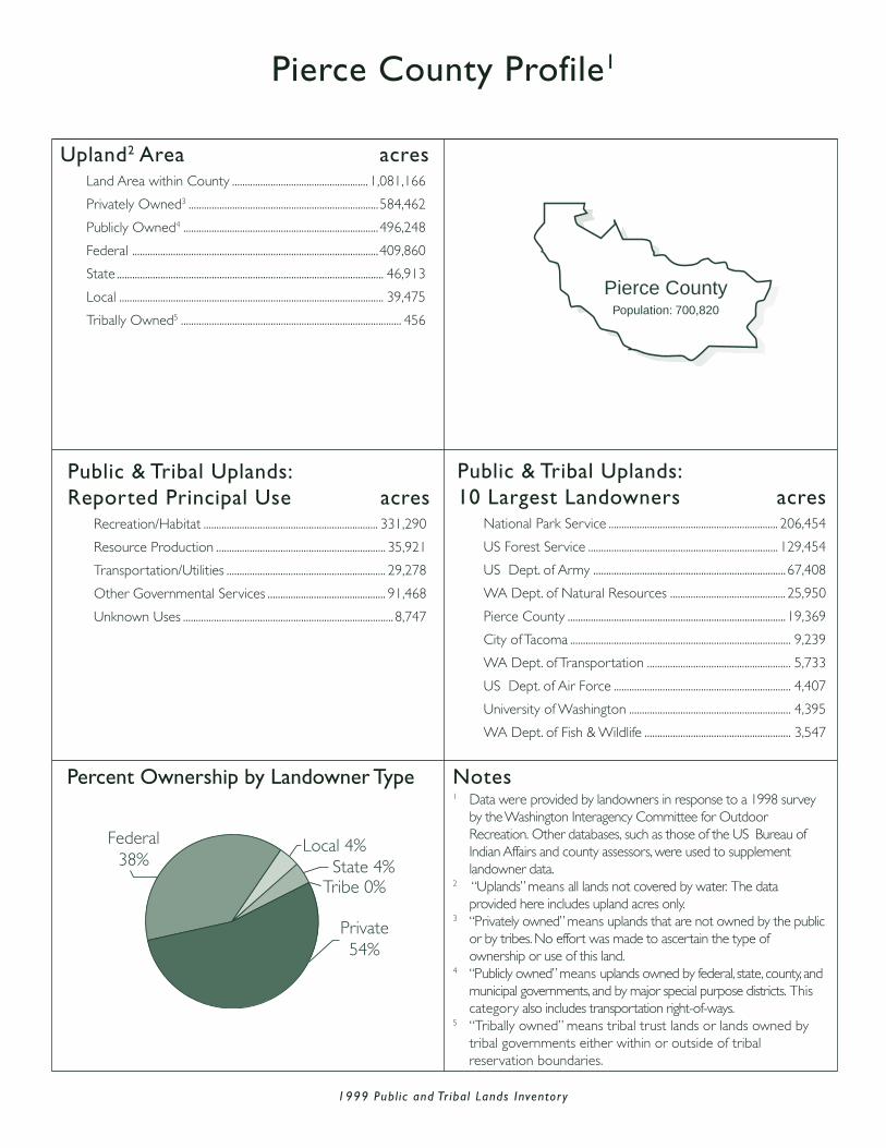
1999 Publ ic and Tr ibal Lands Inventor y
Pierce County Profile1
Upland2 Area acresLand Area within County ..................................................... 1,081,166
Privately Owned3 ..........................................................................584,462
Publicly Owned4 ............................................................................496,248
Federal ................................................................................................409,860
State ........................................................................................................ 46,913
Local ....................................................................................................... 39,475
Tribally Owned5 ...................................................................................... 456
Public & Tribal Uplands:Reported Principal Use acres
Recreation/Habitat .................................................................... 331,290
Resource Production .................................................................. 35,921
Transportation/Utilities .............................................................. 29,278
Other Governmental Services .............................................. 91,468
Unknown Uses .................................................................................. 8,747
Public & Tribal Uplands:10 Largest Landowners acres
National Park Service .................................................................. 206,454
US Forest Service .......................................................................... 129,454
US Dept. of Army ........................................................................... 67,408
WA Dept. of Natural Resources ............................................. 25,950
Pierce County ..................................................................................... 19,369
City of Tacoma ...................................................................................... 9,239
WA Dept. of Transportation ........................................................ 5,733
US Dept. of Air Force ..................................................................... 4,407
University of Washington ............................................................... 4,395
WA Dept. of Fish & Wildlife ......................................................... 3,547
Percent Ownership by Landowner Type
Federal38% State 4%
Local 4%
Tribe 0%
Private54%
Pierce CountyPopulation: 700,820
Notes1 Data were provided by landowners in response to a 1998 survey
by the Washington Interagency Committee for OutdoorRecreation. Other databases, such as those of the US Bureau ofIndian Affairs and county assessors, were used to supplementlandowner data.
2 “Uplands” means all lands not covered by water. The dataprovided here includes upland acres only.
3 “Privately owned” means uplands that are not owned by the publicor by tribes. No effort was made to ascertain the type ofownership or use of this land.
4 “Publicly owned” means uplands owned by federal, state, county, andmunicipal governments, and by major special purpose districts. Thiscategory also includes transportation right-of-ways.
5 “Tribally owned” means tribal trust lands or lands owned bytribal governments either within or outside of tribalreservation boundaries.

1999 Publ ic and Tr ibal Lands Inventor y
San Juan County Profile1
Upland2 Area acresLand Area within County .......................................................... 112,554
Privately Owned3 .............................................................................. 96,720
Publicly Owned4 ................................................................................ 15,808
Federal ...................................................................................................... 2,622
State ............................................................................................................ 9,762
Local ........................................................................................................... 3,424
Tribally Owned5 .......................................................................................... 26
Public & Tribal Uplands:Reported Principal Use acres
Recreation/Habitat ........................................................................... 9,953
Resource Production .......................................................................... 989
Transportation/Utilities .................................................................. 2,817
Other Governmental Services .................................................. 1,479
Unknown Uses ....................................................................................... 596
Public & Tribal Uplands:10 Largest Landowners acres
WA State Parks & Recreation ..................................................... 6,442
San Juan County .................................................................................. 2,423
National Park Service ....................................................................... 1,725
WA Dept. of Natural Resources ............................................... 1,689
University of Washington ............................................................... 1,439
USDOI Bureau of Land Mgmt ........................................................ 892
Town of Friday Harbor ........................................................................ 600
Port of Friday Harbor ........................................................................... 209
WA Dept. of Fish & Wildlife ............................................................. 177
Port of Orcas ............................................................................................... 68
Percent Ownership by Landowner Type
Local 3%
State 9%
Federal 2%
Private86%
Tribe 0%
San Juan County
Population: 14,077
Notes1 Data were provided by landowners in response to a 1998 survey
by the Washington Interagency Committee for OutdoorRecreation. Other databases, such as those of the US Bureau ofIndian Affairs and county assessors, were used to supplementlandowner data.
2 “Uplands” means all lands not covered by water. The dataprovided here includes upland acres only.
3 “Privately owned” means uplands that are not owned by the publicor by tribes. No effort was made to ascertain the type ofownership or use of this land.
4 “Publicly owned” means uplands owned by federal, state, county, andmunicipal governments, and by major special purpose districts. Thiscategory also includes transportation right-of-ways.
5 “Tribally owned” means tribal trust lands or lands owned bytribal governments either within or outside of tribalreservation boundaries.

1999 Publ ic and Tr ibal Lands Inventor y
Skagit County Profile1
Upland2 Area acresLand Area within County ................................................... 1,122,835
Privately Owned3 ........................................................................ 417,414
Publicly Owned4 .......................................................................... 696,758
Federal .............................................................................................. 517,101
State .................................................................................................... 157,319
Local ...................................................................................................... 22,338
Tribally Owned5 ................................................................................. 8,663
Public & Tribal Uplands:Reported Principal Use acres
Recreation/Habitat .................................................................... 509,917
Resource Production ............................................................... 170,923
Transportation/Utilities .............................................................. 19,599
Other Governmental Services ................................................. 2,043
Unknown Uses .................................................................................. 2,939
Public & Tribal Uplands:10 Largest Landowners acres
USDA Forest Service .................................................................. 351,882
National Park Service .................................................................. 164,904
WA Dept. of Natural Resources .......................................... 138,661
City of Seattle ..................................................................................... 11,983
WA Dept. of Fish & Wildlife ....................................................... 11,006
Swinomish Tribe ................................................................................... 7,733
City of Anacortes ............................................................................... 3,674
WA Dept. of Transportation ........................................................ 3,507
WA State Parks & Recreation ..................................................... 3,359
Skagit County ........................................................................................ 1,906
Percent Ownership by Landowner Type
Federal46%
State 14%
Local 2%
Tribe 1%
Private37%
Skagit CountyPopulation: 102,979
Notes1 Data were provided by landowners in response to a 1998 survey
by the Washington Interagency Committee for OutdoorRecreation. Other databases, such as those of the US Bureau ofIndian Affairs and county assessors, were used to supplementlandowner data.
2 “Uplands” means all lands not covered by water. The dataprovided here includes upland acres only.
3 “Privately owned” means uplands that are not owned by the publicor by tribes. No effort was made to ascertain the type ofownership or use of this land.
4 “Publicly owned” means uplands owned by federal, state, county, andmunicipal governments, and by major special purpose districts. Thiscategory also includes transportation right-of-ways.
5 “Tribally owned” means tribal trust lands or lands owned bytribal governments either within or outside of tribalreservation boundaries.

1999 Publ ic and Tr ibal Lands Inventor y
Skamania County Profile1
Upland2 Area acresLand Area within County ...................................................... 1,078,772
Privately Owned3 ........................................................................... 154,595
Publicly Owned4 ............................................................................. 924,177
Federal ................................................................................................. 835,814
State .......................................................................................................... 86,516
Local ........................................................................................................... 1,847
Tribally Owned5 ............................................................................................. 0
Public & Tribal Uplands:Reported Principal Use acres
Recreation/Habitat ..................................................................... 645,722
Resource Production ................................................................ 261,487
Transportation/Utilities ............................................................... 16,134
Other Governmental Services ...................................................... 724
Unknown Uses ....................................................................................... 110
Public & Tribal Uplands:10 Largest Landowners acres
USDA Forest Service .................................................................. 832,233
WA Dept. of Natural Resources ............................................. 80,373
WA State Parks & Recreation ..................................................... 4,675
US Fish and Wildlife Service ....................................................... 1,615
Bonneville Power Administration ............................................... 1,217
WA Dept. of Transportation ........................................................ 1,103
Skamania County ................................................................................ 1,086
US Army Corps of Engineers ......................................................... 611
WA Dept. of Fish & Wildlife ............................................................. 364
City of North Bonneville .................................................................... 254
Percent Ownership by Landowner Type
Federal78%
State 8%Local 0%
Tribe 0%
Private14%
SkamaniaCounty
Population: 9,872
Notes1 Data were provided by landowners in response to a 1998 survey
by the Washington Interagency Committee for OutdoorRecreation. Other databases, such as those of the US Bureau ofIndian Affairs and county assessors, were used to supplementlandowner data.
2 “Uplands” means all lands not covered by water. The dataprovided here includes upland acres only.
3 “Privately owned” means uplands that are not owned by the publicor by tribes. No effort was made to ascertain the type ofownership or use of this land.
4 “Publicly owned” means uplands owned by federal, state, county, andmunicipal governments, and by major special purpose districts. Thiscategory also includes transportation right-of-ways.
5 “Tribally owned” means tribal trust lands or lands owned bytribal governments either within or outside of tribalreservation boundaries.

1999 Publ ic and Tr ibal Lands Inventor y
Snohomish County Profile1
Upland2 Area acresLand Area within County ..................................................... 1,350,614
Privately Owned3 ..........................................................................510,151
Publicly Owned4 ............................................................................830,423
Federal ................................................................................................637,404
State ......................................................................................................161,638
Local ....................................................................................................... 31,381
Tribally Owned5 ............................................................................... 10,040
Public & Tribal Uplands:Reported Principal Use acres
Recreation/Habitat .................................................................... 603,748
Resource Production ............................................................... 196,760
Transportation/Utilities .............................................................. 16,713
Other Governmental Services .............................................. 15,683
Unknown Uses .................................................................................. 7,559
Public & Tribal Uplands:10 Largest Landowners acres
USDA Forest Service .................................................................. 631,030
WA Dept. of Natural Resources .......................................... 147,266
Snohomish County .......................................................................... 11,084
Tulalip Tribes ........................................................................................... 9,914
WA Dept. of Transportation ........................................................ 6,194
City of Everett ...................................................................................... 5,945
Snohomish Co. Public Utility Dist #1 ...................................... 5,627
US Dept. of Navy .............................................................................. 5,198
WA State Parks & Recreation ..................................................... 4,663
WA Dept. of Fish & Wildlife ......................................................... 2,474
Percent Ownership by Landowner Type
Federal47%
State 12%
Local 2%
Tribe 1%
Private38%
Snohomish CountyPopulation: 606,024
Notes1 Data were provided by landowners in response to a 1998 survey
by the Washington Interagency Committee for OutdoorRecreation. Other databases, such as those of the US Bureau ofIndian Affairs and county assessors, were used to supplementlandowner data.
2 “Uplands” means all lands not covered by water. The dataprovided here includes upland acres only.
3 “Privately owned” means uplands that are not owned by the publicor by tribes. No effort was made to ascertain the type ofownership or use of this land.
4 “Publicly owned” means uplands owned by federal, state, county, andmunicipal governments, and by major special purpose districts. Thiscategory also includes transportation right-of-ways.
5 “Tribally owned” means tribal trust lands or lands owned bytribal governments either within or outside of tribalreservation boundaries.

1999 Publ ic and Tr ibal Lands Inventor y
Spokane County Profile1
Upland2 Area acresLand Area within County ..................................................... 1,141,307
Privately Owned3 ...................................................................... 1,018,231
Publicly Owned4 ............................................................................123,036
Federal .................................................................................................. 23,276
State ........................................................................................................ 56,448
Local ....................................................................................................... 43,312
Tribally Owned5 ......................................................................................... 40
Public & Tribal Uplands:Reported Principal Use acres
Recreation/Habitat ....................................................................... 49,608
Resource Production .................................................................. 26,353
Transportation/Utilities .............................................................. 39,040
Other Governmental Services ................................................. 7,772
Unknown Uses ..................................................................................... 303
Public & Tribal Uplands:10 Largest Landowners acres
Spokane County .............................................................................. 26,026
WA Dept. of Natural Resources ........................................... 24,618
WA State Parks & Recreation ................................................. 22,495
WA Dept. of Fish & Wildlife ..................................................... 15,468
City of Spokane ............................................................................... 13,080
WA Dept. of Transportation ....................................................... 7,149
US Dept. of Air Force ...................................................................... 4,651
City of Deer Park .............................................................................. 1,876
USDOI Bureau of Land Mgmt ................................................... 1,406
Bonneville Power Administration .............................................. 1,129
Percent Ownership by Landowner Type
Private89% Local 4%
Federal 2%
State 5%Tribe 0%
Spokane CountyPopulation: 417,939
Notes1 Data were provided by landowners in response to a 1998 survey
by the Washington Interagency Committee for OutdoorRecreation. Other databases, such as those of the US Bureau ofIndian Affairs and county assessors, were used to supplementlandowner data.
2 “Uplands” means all lands not covered by water. The dataprovided here includes upland acres only.
3 “Privately owned” means uplands that are not owned by the publicor by tribes. No effort was made to ascertain the type ofownership or use of this land.
4 “Publicly owned” means uplands owned by federal, state, county, andmunicipal governments, and by major special purpose districts. Thiscategory also includes transportation right-of-ways.
5 “Tribally owned” means tribal trust lands or lands owned bytribal governments either within or outside of tribalreservation boundaries.

1999 Publ ic and Tr ibal Lands Inventor y
Stevens County Profile1
Upland2 Area acresLand Area within County ..................................................... 1,625,550
Privately Owned3 ...................................................................... 1,009,366
Publicly Owned4 ............................................................................484,397
Federal ................................................................................................313,044
State ......................................................................................................166,442
Local .......................................................................................................... 4,911
Tribally Owned5 .............................................................................131,787
Public & Tribal Uplands:Reported Principal Use acres
Recreation/Habitat .................................................................... 117,395
Resource Production ............................................................... 319,390
Transportation/Utilities .............................................................. 43,044
Other Governmental Services .................................................... 932
Unknown Uses ............................................................................ 135,423
Public & Tribal Uplands:10 Largest Landowners acres
USDA Forest Service .................................................................217,961
WA Dept. of Natural Resources .........................................162,479
Spokane Tribe ..................................................................................131,787
US Fish and Wildlife Service ................................................... 39,987
US Bureau of Reclamation ....................................................... 30,499
USDOI Bureau of Land Mgmt ................................................ 24,494
WA Dept. of Transportation ....................................................... 3,530
Stevens County ................................................................................... 3,120
City of Colville ..................................................................................... 1,112
WA Dept. of Fish & Wildlife ............................................................ 262
Percent Ownership by Landowner Type
Federal19%
State10%
Local 0%
Tribe 8%
Private63%
StevensCountyPopulation:
40,066
Notes1 Data were provided by landowners in response to a 1998 survey
by the Washington Interagency Committee for OutdoorRecreation. Other databases, such as those of the US Bureau ofIndian Affairs and county assessors, were used to supplementlandowner data.
2 “Uplands” means all lands not covered by water. The dataprovided here includes upland acres only.
3 “Privately owned” means uplands that are not owned by the publicor by tribes. No effort was made to ascertain the type ofownership or use of this land.
4 “Publicly owned” means uplands owned by federal, state, county, andmunicipal governments, and by major special purpose districts. Thiscategory also includes transportation right-of-ways.
5 “Tribally owned” means tribal trust lands or lands owned bytribal governments either within or outside of tribalreservation boundaries.
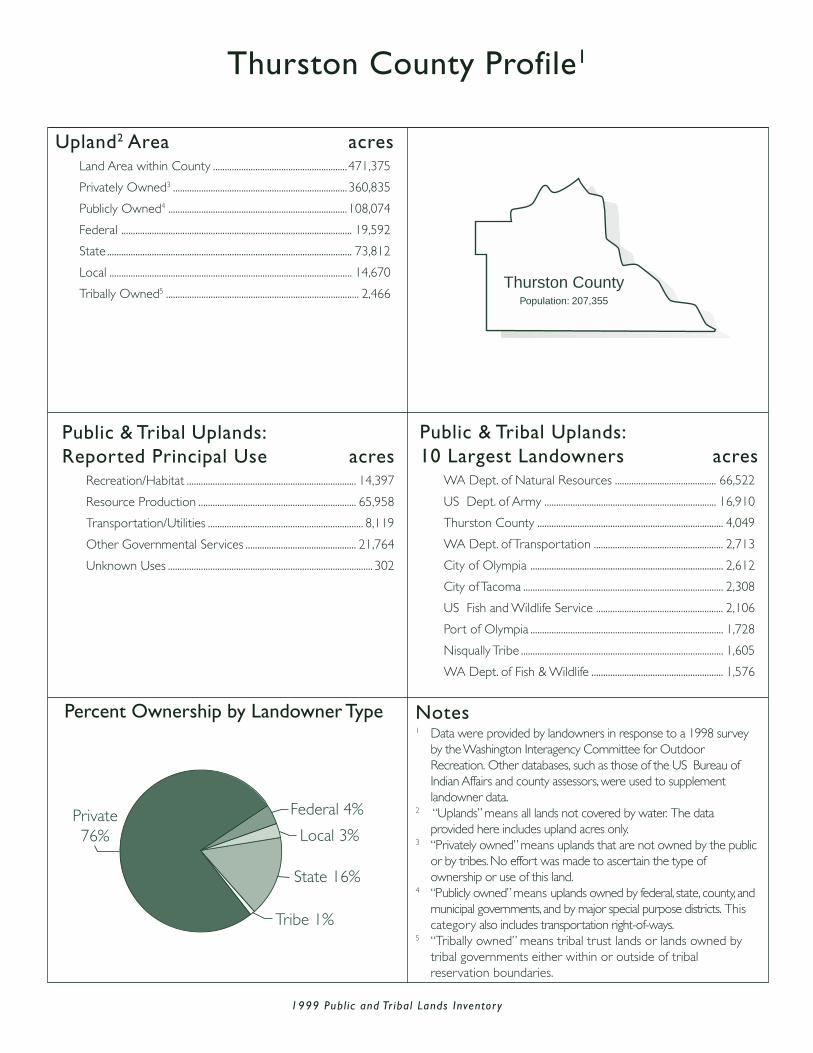
1999 Publ ic and Tr ibal Lands Inventor y
Thurston County Profile1
Upland2 Area acresLand Area within County .........................................................471,375
Privately Owned3 ..........................................................................360,835
Publicly Owned4 ............................................................................108,074
Federal .................................................................................................. 19,592
State ........................................................................................................ 73,812
Local ....................................................................................................... 14,670
Tribally Owned5 .................................................................................. 2,466
Public & Tribal Uplands:Reported Principal Use acres
Recreation/Habitat ........................................................................ 14,397
Resource Production ................................................................... 65,958
Transportation/Utilities .................................................................. 8,119
Other Governmental Services ............................................... 21,764
Unknown Uses ....................................................................................... 302
Public & Tribal Uplands:10 Largest Landowners acres
WA Dept. of Natural Resources ........................................... 66,522
US Dept. of Army ......................................................................... 16,910
Thurston County ............................................................................... 4,049
WA Dept. of Transportation ....................................................... 2,713
City of Olympia .................................................................................. 2,612
City of Tacoma ..................................................................................... 2,308
US Fish and Wildlife Service ...................................................... 2,106
Port of Olympia .................................................................................. 1,728
Nisqually Tribe ...................................................................................... 1,605
WA Dept. of Fish & Wildlife ........................................................ 1,576
Percent Ownership by Landowner Type
Private76% Local 3%
Federal 4%
State 16%
Tribe 1%
Thurston CountyPopulation: 207,355
Notes1 Data were provided by landowners in response to a 1998 survey
by the Washington Interagency Committee for OutdoorRecreation. Other databases, such as those of the US Bureau ofIndian Affairs and county assessors, were used to supplementlandowner data.
2 “Uplands” means all lands not covered by water. The dataprovided here includes upland acres only.
3 “Privately owned” means uplands that are not owned by the publicor by tribes. No effort was made to ascertain the type ofownership or use of this land.
4 “Publicly owned” means uplands owned by federal, state, county, andmunicipal governments, and by major special purpose districts. Thiscategory also includes transportation right-of-ways.
5 “Tribally owned” means tribal trust lands or lands owned bytribal governments either within or outside of tribalreservation boundaries.
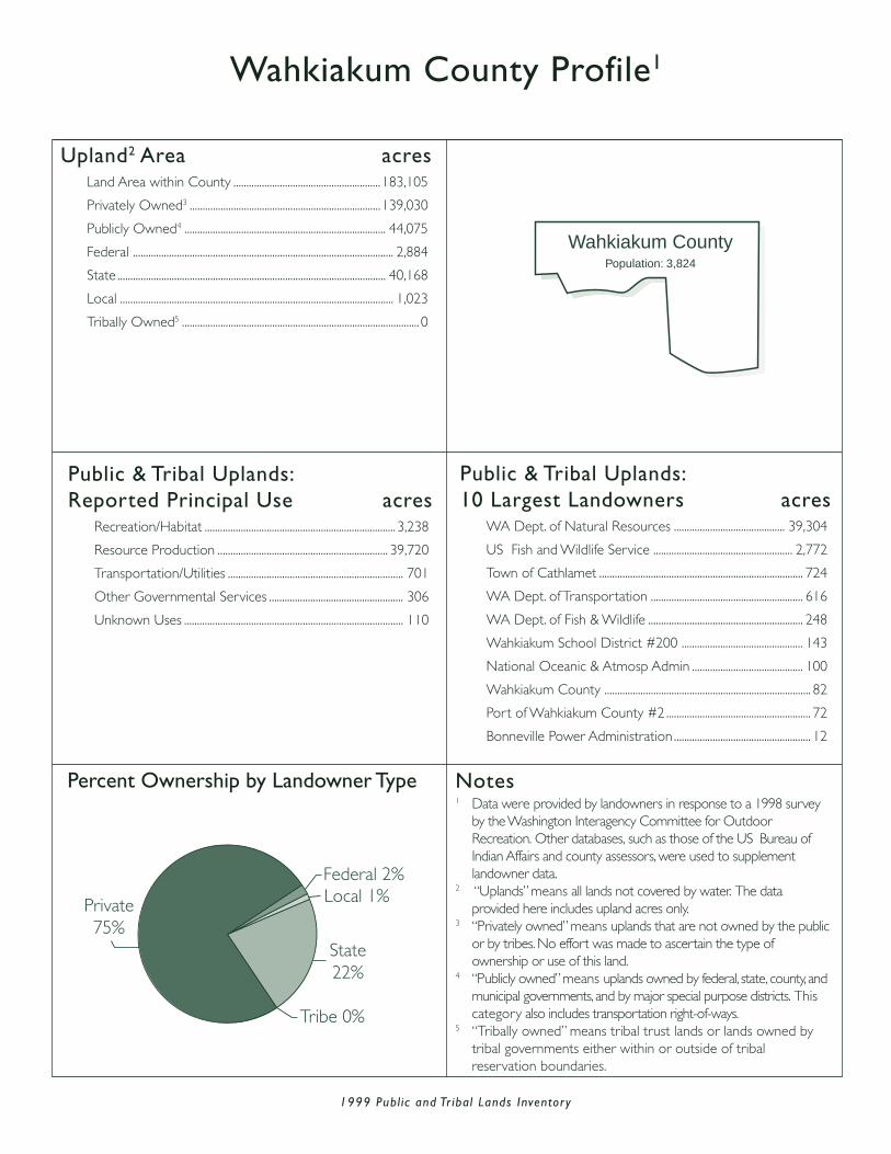
1999 Publ ic and Tr ibal Lands Inventor y
Wahkiakum County Profile1
Upland2 Area acresLand Area within County .........................................................183,105
Privately Owned3 ..........................................................................139,030
Publicly Owned4 .............................................................................. 44,075
Federal ..................................................................................................... 2,884
State ........................................................................................................ 40,168
Local .......................................................................................................... 1,023
Tribally Owned5 ............................................................................................ 0
Public & Tribal Uplands:Reported Principal Use acres
Recreation/Habitat .......................................................................... 3,238
Resource Production .................................................................. 39,720
Transportation/Utilities .................................................................... 701
Other Governmental Services .................................................... 306
Unknown Uses ..................................................................................... 110
Public & Tribal Uplands:10 Largest Landowners acres
WA Dept. of Natural Resources ........................................... 39,304
US Fish and Wildlife Service ...................................................... 2,772
Town of Cathlamet ............................................................................... 724
WA Dept. of Transportation ........................................................... 616
WA Dept. of Fish & Wildlife ............................................................ 248
Wahkiakum School District #200 ............................................... 143
National Oceanic & Atmosp Admin ........................................... 100
Wahkiakum County ................................................................................ 82
Port of Wahkiakum County #2 ........................................................ 72
Bonneville Power Administration ..................................................... 12
Percent Ownership by Landowner Type
Federal 2%
State22%
Local 1%
Tribe 0%
Private75%
Wahkiakum CountyPopulation: 3,824
Notes1 Data were provided by landowners in response to a 1998 survey
by the Washington Interagency Committee for OutdoorRecreation. Other databases, such as those of the US Bureau ofIndian Affairs and county assessors, were used to supplementlandowner data.
2 “Uplands” means all lands not covered by water. The dataprovided here includes upland acres only.
3 “Privately owned” means uplands that are not owned by the publicor by tribes. No effort was made to ascertain the type ofownership or use of this land.
4 “Publicly owned” means uplands owned by federal, state, county, andmunicipal governments, and by major special purpose districts. Thiscategory also includes transportation right-of-ways.
5 “Tribally owned” means tribal trust lands or lands owned bytribal governments either within or outside of tribalreservation boundaries.

1999 Publ ic and Tr ibal Lands Inventor y
Walla Walla County Profile1
Upland2 Area acresLand Area within County .........................................................831,087
Privately Owned3 ..........................................................................765,394
Publicly Owned4 .............................................................................. 65,693
Federal .................................................................................................. 27,474
State ........................................................................................................ 23,600
Local ....................................................................................................... 14,619
Tribally Owned5 ............................................................................................ 0
Public & Tribal Uplands:Reported Principal Use acres
Recreation/Habitat ........................................................................... 7,872
Resource Production ................................................................... 20,336
Transportation/Utilities ............................................................... 32,772
Other Governmental Services .................................................. 4,187
Unknown Uses ....................................................................................... 526
Public & Tribal Uplands:10 Largest Landowners acres
WA Dept. of Natural Resources ........................................... 20,470
US Army Corps of Engineers ................................................. 20,258
Walla Walla County .......................................................................... 7,678
USDA Forest Service ...................................................................... 3,319
US Fish and Wildlife Service ...................................................... 3,253
City of Walla Walla ............................................................................ 3,175
Port of Walla Walla ........................................................................... 2,816
WA Dept. of Transportation ....................................................... 2,268
WA Dept. of Corrections ................................................................. 548
USDOI Bureau of Land Mgmt ....................................................... 411
Percent Ownership by Landowner Type
Private92%
Local 2%Federal 3%
State 3%Tribe 0%
Walla Walla CountyPopulation: 55,180
Notes1 Data were provided by landowners in response to a 1998 survey
by the Washington Interagency Committee for OutdoorRecreation. Other databases, such as those of the US Bureau ofIndian Affairs and county assessors, were used to supplementlandowner data.
2 “Uplands” means all lands not covered by water. The dataprovided here includes upland acres only.
3 “Privately owned” means uplands that are not owned by the publicor by tribes. No effort was made to ascertain the type ofownership or use of this land.
4 “Publicly owned” means uplands owned by federal, state, county, andmunicipal governments, and by major special purpose districts. Thiscategory also includes transportation right-of-ways.
5 “Tribally owned” means tribal trust lands or lands owned bytribal governments either within or outside of tribalreservation boundaries.

1999 Publ ic and Tr ibal Lands Inventor y
Whatcom County Profile1
Upland2 Area acresLand Area within County ..................................................... 1,385,611
Privately Owned3 ..........................................................................429,509
Publicly Owned4 ............................................................................936,509
Federal ................................................................................................818,423
State ......................................................................................................108,238
Local .......................................................................................................... 9,848
Tribally Owned5 ............................................................................... 19,593
Public & Tribal Uplands:Reported Principal Use acres
Recreation/Habitat ..................................................................... 817,424
Resource Production ................................................................ 115,987
Transportation/Utilities .................................................................. 8,333
Other Governmental Services .................................................. 3,171
Unknown Uses ................................................................................ 11,187
Public & Tribal Uplands:10 Largest Landowners acres
USDA Forest Service .................................................................429,294
National Park Service .................................................................388,756
WA Dept. of Natural Resources ........................................... 98,684
Lummi Nation ................................................................................... 19,590
WA Dept. of Transportation ....................................................... 4,206
Whatcom County ............................................................................. 3,875
WA State Parks & Recreation .................................................... 2,705
WA Dept. of Fish & Wildlife ........................................................ 2,287
City of Bellingham.............................................................................. 2,250
Port of Bellingham ............................................................................. 1,183
Percent Ownership by Landowner Type
Federal59% State 8%
Local 1%
Tribe 1%
Private31%
Whatcom CountyPopulation: 166,814
Notes1 Data were provided by landowners in response to a 1998 survey
by the Washington Interagency Committee for OutdoorRecreation. Other databases, such as those of the US Bureau ofIndian Affairs and county assessors, were used to supplementlandowner data.
2 “Uplands” means all lands not covered by water. The dataprovided here includes upland acres only.
3 “Privately owned” means uplands that are not owned by the publicor by tribes. No effort was made to ascertain the type ofownership or use of this land.
4 “Publicly owned” means uplands owned by federal, state, county, andmunicipal governments, and by major special purpose districts. Thiscategory also includes transportation right-of-ways.
5 “Tribally owned” means tribal trust lands or lands owned bytribal governments either within or outside of tribalreservation boundaries.

1999 Publ ic and Tr ibal Lands Inventor y
Whitman County Profile1
Upland2 Area acresLand Area within County ..................................................... 1,393,366
Privately Owned3 ...................................................................... 1,328,590
Publicly Owned4 .............................................................................. 64,776
Federal .................................................................................................. 21,230
State ........................................................................................................ 40,640
Local .......................................................................................................... 2,906
Tribally Owned5 ............................................................................................ 0
Public & Tribal Uplands:Reported Principal Use acres
Recreation/Habitat ........................................................................... 4,286
Resource Production ................................................................... 36,058
Transportation/Utilities ............................................................... 18,731
Other Governmental Services .................................................. 4,609
Unknown Uses ................................................................................... 1,092
Public & Tribal Uplands:10 Largest Landowners acres
WA Dept. of Natural Resources ........................................... 27,760
US Army Corps of Engineers ................................................. 12,527
USDOI Bureau of Land Mgmt ................................................... 8,298
Washington State University ....................................................... 5,225
WA Dept. of Transportation ....................................................... 4,947
WA Dept. of Fish & Wildlife ........................................................ 2,291
Whitman County ................................................................................... 844
City of Pullman ........................................................................................ 695
Port of Whitman County .................................................................. 507
WA State Parks & Recreation ........................................................ 416
Percent Ownership by Landowner Type
Private95%
Local 2%Federal 3%
State 3%
Tribe 0%
Whitman CountyPopulation: 40,740
Notes1 Data were provided by landowners in response to a 1998 survey
by the Washington Interagency Committee for OutdoorRecreation. Other databases, such as those of the US Bureau ofIndian Affairs and county assessors, were used to supplementlandowner data.
2 “Uplands” means all lands not covered by water. The dataprovided here includes upland acres only.
3 “Privately owned” means uplands that are not owned by the publicor by tribes. No effort was made to ascertain the type ofownership or use of this land.
4 “Publicly owned” means uplands owned by federal, state, county, andmunicipal governments, and by major special purpose districts. Thiscategory also includes transportation right-of-ways.
5 “Tribally owned” means tribal trust lands or lands owned bytribal governments either within or outside of tribalreservation boundaries.

1999 Publ ic and Tr ibal Lands Inventor y
Yakima County Profile1
Upland2 Area acresLand Area within County ..................................................... 2,758,913
Privately Owned3 ..........................................................................686,623
Publicly Owned4 ............................................................................941,249
Federal ................................................................................................698,372
State ......................................................................................................233,921
Local .......................................................................................................... 8,956
Tribally Owned5 ......................................................................... 1,131,041
Public & Tribal Uplands:Reported Principal Use acres
Recreation/Habitat ..................................................................... 498,742
Resource Production ................................................................ 258,114
Transportation/Utilities ............................................................... 26,513
Other Governmental Services ............................................ 157,580
Unknown Uses ......................................................................... 1,131,341
Public & Tribal Uplands:10 Largest Landowners acres
Yakama Nation ........................................................................... 1,131,041
USDA Forest Service .................................................................501,133
US Dept. of Army .......................................................................155,041
WA Dept. of Natural Resources .........................................147,958
WA Dept. of Fish & Wildlife ..................................................... 75,722
USDOI Bureau of Land Mgmt ................................................ 26,531
US Bureau of Reclamation ....................................................... 13,232
WA Dept. of Transportation ....................................................... 9,473
Yakima County .................................................................................... 2,516
US Fish and Wildlife Service ...................................................... 2,299
Percent Ownership by Landowner Type
Federal25%
State 8%
Local 0%
Tribe42%
Private25%
Yakima CountyPopulation: 222,581
Notes1 Data were provided by landowners in response to a 1998 survey
by the Washington Interagency Committee for OutdoorRecreation. Other databases, such as those of the US Bureau ofIndian Affairs and county assessors, were used to supplementlandowner data.
2 “Uplands” means all lands not covered by water. The dataprovided here includes upland acres only.
3 “Privately owned” means uplands that are not owned by the publicor by tribes. No effort was made to ascertain the type ofownership or use of this land.
4 “Publicly owned” means uplands owned by federal, state, county, andmunicipal governments, and by major special purpose districts. Thiscategory also includes transportation right-of-ways.
5 “Tribally owned” means tribal trust lands or lands owned bytribal governments either within or outside of tribalreservation boundaries.
Recommended