1
From GPS and Virtual Globes to Spatial Computing - 2020: The Next Transformative Technology
A Community Whitepaper
October 15, 2012
1. Introduction
Spatial Computing is a set of ideas and technologies that will transform our lives by
understanding the physical world, knowing and communicating our relation to places in that world, and
navigating through those places.
The transformational potential of Spatial Computing is already evident. From virtual maps to
consumer GPS devices, our society has benefitted immensely from spatial technology. We’ve reached
the point where a hiker in Yellowstone, a schoolgirl in DC, a biker in Minneapolis, and a taxi driver in
Manhattan know precisely where they are, nearby points of interest, and how to reach their destinations.
Large organizations already use Spatial Computing for site-selection, asset tracking, facility management,
navigation and logistics. Scientists use GPS to track endangered species to better understand behavior
and farmers use GPS for precision agriculture to increase crop yields while reducing costs. Virtual Globes
[18] (e.g., Google Earth, NASA World Wind) is being used in classrooms to teach children about their
neighborhoods and the world in a fun and interactive way. Augmented reality applications (such as
Google Goggles) [35, 54] are providing real-time place-labeling in the physical world and providing people
detailed information about major landmarks nearby.
1.1 Why Spatial Computing?
Spatial Computing has also transformed how we access, store, visualize, and make use of geo-
graphic data. Imagine life without GPS-enabled smart phones, or emergency operations without
interactive, dynamic maps. In the wake of many recent natural disasters, Google Earth has been used as
a service to allow millions of people to access imagery to help in disaster recovery services [37]. After
Hurricane Katrina, nearly 4,000 post-hurricane images were made available in Google Earth for the US
Army Corps of Engineers to assess levee damage [11]. Within days of the 2010 Haiti earthquake,
navigable digital roadmaps were available on OpenStreetMap [41]. Similarly, news media, educators, and
activists use dynamic maps to help communicate with the public by adding spatial context to information.
Learning about the environmental impacts of mining via mountaintop removal is much more powerful
when one can see the visual context via a simulated 3-d map.
More recently, Spatial Computing has begun to transform the way we shop by identifying local
services–ranging from home-maintenance providers (e.g., lawn services, remodeling, and lock-smithing)
to nearby deals and promotions for a variety of goods (e.g., flowers, clothes) and services (e.g., theater
tickets, restaurant coupons). Many already use location-based services [48] to get recommendations and
deals based on their current location [25]. For example, Walgreens has offered discounts to shoppers
who check in on Foursquare. And in just over two years, location-based daily- deal website Groupon has
accumulated 60 million subscribers and $760 million in annual revenue to become the fastest-growing
Web company ever [7]. Even our socializing habits are being shaped by location-based social networks
(e.g., Foursquare, Facebook check-in, Twitter), which allow us to locate our friends in real-time for
impromptu get-togethers.
In addition, Spatial Computing has transformed public services. Spatial aspects, e.g.,
neighborhood context [51], are critical in understanding many contributors to disease process including
environmental toxicant exposure as well as human behavior and lifestyle choices. This exposome, a
2
characterization of a person’s lifetime exposures, is becoming an increasingly popular subject of research
for public health [47, 30]. Public safety professionals use spatial analysis to identify crime hotspots to
select police patrol routes, social interventions, etc. Epidemiologists use spatial analysis techniques [4] to
identify cancer clusters [46] (i.e., locations with unusually high densities) and track infectious disease
such as SARS and bird flu. Emergency managers use spatial analysis to identify routes to evacuate
vulnerable populations to safety.
Spatial Computing has revolutionized national defense [9, 36, 38] as well. From stealth route
selection (i.e., the practice of navigating through terrain without detection) to precision-guided weapons,
spatial technologies permeate through every aspect of national security. Situational awareness in battle
starts with maps of locations, environments, terrains, and intelligence about adversary placement and
movement. Recently, the US-DoD has started a GPS modernization (GPS-III) effort due to rising
concerns of adversarial jamming [52].
Spatial Computing has also begun transforming the Internet - transforming our way of living and
social interactions. The incorporation of location information for Internet entities such as users,
documents and servers allows a flourishing of services designed around enhanced usability, security and
trust. For example, the way information is categorized on the Internet can be augmented with spatial
information. Currently we access information based on keywords and references, but a large portion of
information has an inherent spatial component. Storing and referencing data by location may allow for
more intuitive searching and knowledge discovery. It would then be possible to draw correlations and find
new information based on relative locations, rather than keywords.
One may address broader questions related to the philosophy of science. Many traditional
scholars look for unified theories across all locations, time frames, scales and phenomena. However,
many spatial thinkers believe that place-based models may be more accurate and effective due to spatial
heterogeneity, at least in the early stages of a new field of knowledge. Spatial Computing may facilitate a
debate comparing global theories and place-based (or time- based) theories and their place in evolving
fields of knowledge, e.g., understanding the impact of climate change for different cities and countries.
Spatial computing has also started to impact the use of geospatial reasoning in sensing and
inference across space and time. Multiple tradeoffs (including those arising in privacy considerations) can
come to the fore with attempts to sense and draw inferences from stable or mobile sensors. New
challenges arise from crowd-sourced sensors. For example, the ubiquity of mobile phones presents an
incredible opportunity for gathering information about all aspects of our world and the people living in it
[27]. Already research has shown the potential for mobile phones with built-in motion detectors carried by
everyday users to detect earthquakes mere seconds after they begin [12]. Navigation companies
frequently utilize mobile phone records to estimate traffic levels on busy highways [53]. How can
computers efficiently utilize this prevalent sensing power of mobile phones without drastically impacting
battery life or personal privacy concerns? This raises many computer science questions related to sensor
placement, configuration, etc.
Spatial computing need not only apply to geographic space. Other spaces, such as the human
body in medicine or micro and nano structures in material science may benefit immensely from spatial
computing. Spatio-temporal datasets in medicine include 3-D images (e.g., CT and MRI) and spatial
networks in the body (e.g., circulatory system). New research problems include: defining a frame of
reference for the human body [45], determining spatial changes in lesions, and finding minimally invasive
routes for neurosurgery to remove a malignant tumor. In material science, spatial ideas such as point
processes and spatial autocorrelation may help characterize the spatial distribution of defects on silicon
wafers [55].
Unique contributions of spatial thinking to computer and information sciences include map
projections, scale, auto-correlation, heterogeneity, non-stationarity, etc. [50]. The first two impact
computation of spatial distance, area, direction, shortest paths, etc. Autocorrelation refers to the
observation that nearby locations tend to be similar. Such spatial and temporal auto-correlation violate
3
common-place independence assumptions in traditional statistics and data mining and have led to spatial
statistics and spatial data mining [49]. Heterogeneity (and non-stationarity) refers to the observation that
no two geo-locations (or calendar-days) are alike. Thus, the ranking of candidate solutions for a problem
may vary across location and time–violating the stationary assumption underlying dynamic programming,
a popular algorithm design paradigm. To address this challenge, Spatial Computing has provided new
algorithm design paradigms [19].
Forthcoming Age of Spatial Computing: The above examples are all early indicators of the likely
impact of Spatial Computing. The US Department of Labor has identified geospatial technologies, along
with nanotechnology and biotechnology, as one of the three most important high-growth industries for the
21st century [16]. The Congressional Research Service published a recent report on GIS [15] listing 19
federal agencies who consider Spatial Computing a mission- critical technology. The United Nations
published 15 Global Challenges to “provide a framework to assess the global and local prospects for
humanity.” Many of these challenges are inherently spatial problems, such as maintaining clean water,
sustainable development, energy production, and peace and conflict [23]. Spatial Computing is essential
to computational advances in addressing the global challenges. The Association for Computing
Machinery (ACM) in 2008 created a new Special Interest Group (SIG) for Spatial Computing
(SIGSPATIAL).
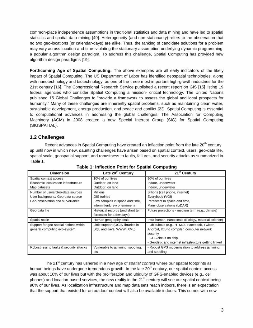
1.2 Challenges
Recent advances in Spatial Computing have created an inflection point from the late 20th century
up until now in which new, daunting challenges have arisen based on spatial context, users, geo-data life,
spatial scale, geospatial support, and robustness to faults, failures, and security attacks as summarized in
Table 1.
Table 1: Inflection Point for Spatial Computing
Dimension Late 20th
Century 21st
Century
Spatial context access
Economic localization infrastructure
Map datasets
10% of our lives
Outdoor, on land
Outdoor, on land
90% of our lives
Indoor, underwater
Indoor, underwater
Number of users/Geo-data sources
User background/ Geo-data source
Geo-observation and surveillance
Millions
GIS trained
Few samples in space and time,
intermittent, few phenomena
Billions (cell phone, internet)
Everybody (VGI)
Persistent in space and time,
Many observations (LiDAR)
Geo-data life Historical records (and short term
forecasts for a few days)
Future projections - medium term (e.g., climate)
Spatial scale Human geography scale Intra-human, nano scale (Biology, material science)
Support for geo-spatial notions within
general computing eco-system
Little support (OGIS libraries in
SQL and Java, WWW, XML)
- Ubiquitous (e.g., HTML5, Facebook, Twitter,-
Android, IOS to compiler, computer network
security
- GPS circuit on chip
- Geodetic and internet infrastructure getting linked
Robustness to faults & security attacks Vulnerable to jamming, spoofing,
etc
- Robust GPS modernization to address jamming
and spoofing
The 21st century has ushered in a new age of spatial context where our spatial footprints as
human beings have undergone tremendous growth. In the late 20th century, our spatial context access
was about 10% of our lives but with the proliferation and ubiquity of GPS-enabled devices (e.g., cell
phones) and location-based services, the new reality in the 21st century will see our spatial context being
90% of our lives. As localization infrastructure and map data sets reach indoors, there is an expectation
that the support that existed for an outdoor context will also be available indoors. This comes with new
4
challenges as it is unclear how notions such as nodes, edges, shortest paths, average speed, etc. will
translate in an indoor context. In other words, localization infrastructure and map data sets are being
challenged to keep up with us wherever we go.
Billions of users with cell phones and access to the internet is the new reality of the 21st century
versus millions of users from the late 20th century. The sources of geo-data are now users who are
untrained and unqualified (e.g., volunteered geographic information) which means data quality may be
uncertain since the public may not be trained in making specific observations and may unwittingly
contribute erroneous information. How can one accurately determine location (and orientation) of mobile
clients in GPS-denied spaces such as indoors or underground? How do we represent spatio-temporal
concepts with incomplete/ uncertain information, with alternative data models, and possibly with multiple
representations for the same data, in digital environments? How do we measure spatio-temporal
concepts, recognize them in remotely sensed information or in the field, and identify their accuracy and
quality? This new geo-data source will provide a wealth of information for applications such as geo-
observation and surveillance, which has transitioned from intermittent readings with a few samples
persistent observations with many samples in space and time. Handling the plethora of information
provides a challenge to the next generation of spatial computing technologies. What new SC
opportunities will arise from trends in sensors (e.g., LiDAR), sensor platforms (e.g., mobile phones) and
sensor networks (e.g., traffic, weather)? Table B.1 shows additional examples of emerging platform
trends where growth in number of users and data sources has gone from millions to billions.
For geo-data life, the late 20th century saw focus mainly on historic records or even short term
forecasts for a few days. The 21st century requires future projections for the medium term such as with
climate data. For example, Spatial Computing may facilitate a debate comparing global theories and time-
based theories and their place in understanding the impact of climate change for different cities and
countries. Challenging questions emerge such as: What are algorithm design paradigms for spatio-
temporal problems which violate the dynamic programming assumptions of stationary ranking of
candidates? How do we conceptualize spatio-temporal world for computing? How do we explain spatio-
temporal phenomena through the application of appropriate methods of analysis, and models of physical
and human processes? How do we use spatio-temporal concepts to think about spatio-temporal
phenomena, and to seek explanations for spatio-temporal patterns and phenomena?
Spatial scale will see us moving from a human geography scale to an intra-human or nano-scale
in the 21st century. How should scale be addressed? How should data be organized (by layer, by feature
type, etc.), and how should it be indexed for rapid search? Although ST databases have traditionally been
used to manage geographic data, the human body is another important low dimensional physical space
which is extensively measured, queried and analyzed in the field of medicine. The 21st century promises a
spatio-temporal framework for monitoring health status over the long term (via dental X-rays,
mammograms, etc.) or predicting when an anomalous decay or growth will change in size. An ST
framework may play an important role in improving health care quality by providing answers on the
progression of disease and the treatment of several pathologies (e.g., cancer). Answering long term
questions based on ST medical data sets gathered over time raises several conceptual and
computational challenges such as developing a reference frame analogous to latitude/longitude for the
human body, implementing location determination methods to know where we are in the body, developing
routing techniques in a continuous space where no roads are defined to reduce the invasiveness of
certain procedures, defining and capturing change across two images for understanding trends, and
scalability to potential petabyte and exabyte-sized data sets.
Support for geo-spatial notions within the general computing eco-system has been rich at the OS
an application level but more support will be needed for lower layers for next-generation spatial
computing. For the best balance between performance and flexibility, what is the appropriate allocation of
spatial data-types and operations across hardware, assembly language, OS kernel, run-time systems,
network stack, database management systems, geographic information systems and application
5
programs? Support for geo-spatial notions will be needed for compilers and computer network security.
The possibility exists that GPS circuits will be needed on chip and geodetic and internet infrastructure will
need to be linked.
The 21st century of spatial computing technologies promises robustness to faults, failures, and
security attacks. Spatial computing technologies have been vulnerable to jamming and spoofing but the
21st century will require more robust spatial computing systems where GPS modernization will be needed
to address jamming and spoofing. New questions will need to be addressed such as: what are scalable
and numerically robust algorithms for spatial statistical modeling?
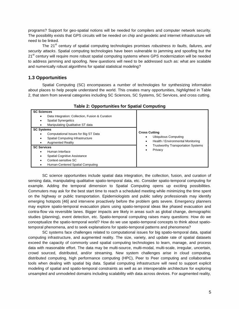
1.3 Opportunities
Spatial Computing (SC) encompasses a number of technologies for synthesizing information
about places to help people understand the world. This creates many opportunities, highlighted in Table
2, that stem from several categories including SC Sciences, SC Systems, SC Services, and cross cutting.
Table 2: Opportunities for Spatial Computing
SC Sciences
Data Integration: Collection, Fusion & Curation
Spatial Synergetics
Manipulating Qualitative ST data
Cross Cutting
Ubiquitous Computing
Health / Environmental Monitoring
Trustworthy Transportation Systems
Privacy
SC Systems
Computational Issues for Big ST Data
Spatial Computing Infrastructure
Augmented Reality
SC Services
Human Interface
Spatial Cognitive Assistance
Context-sensitive SC
Human-Centered Spatial Computing
SC science opportunities include spatial data integration, the collection, fusion, and curation of
sensing data, manipulating qualitative spatio-temporal data, etc. Consider spatio-temporal computing for
example. Adding the temporal dimension to Spatial Computing opens up exciting possibilities.
Commuters may ask for the best start time to reach a scheduled meeting while minimizing the time spent
on the highway or public transportation. Epidemiologists and public safety professionals may identify
emerging hotspots [46] and intervene proactively before the problem gets severe. Emergency planners
may explore spatio-temporal evacuation plans using spatio-temporal ideas like phased evacuation and
contra-flow via reversible lanes. Bigger impacts are likely in areas such as global change, demographic
studies (planning), event detection, etc. Spatio-temporal computing raises many questions: How do we
conceptualize the spatio-temporal world? How do we use spatio-temporal concepts to think about spatio-
temporal phenomena, and to seek explanations for spatio-temporal patterns and phenomena?
SC systems face challenges related to computational issues for big spatio-temporal data, spatial
computing infrastructure, and augmented reality. The size, variety, and update rate of spatial datasets
exceed the capacity of commonly used spatial computing technologies to learn, manage, and process
data with reasonable effort. The data may be multi-source, multi-modal, multi-scale, irregular, uncertain,
crowd sourced, distributed, and/or streaming. New system challenges arise in cloud computing,
distributed computing, high performance computing (HPC), Peer to Peer computing and collaborative
tools when dealing with spatial big data. Spatial computing infrastructure will need to support explicit
modeling of spatial and spatio-temporal constraints as well as an interoperable architecture for exploring
unsampled and unmodeled domains including scalability with data across devices. For augmented reality,
6
automated, accurate, and scalable retrieval, recognition, and presentation of augmented information is
non-trivial.
SC services opportunities involve the human interface, spatial cognitive assistance, context-
sensitive spatial computing, and human-centered spatial computing. The human interface presents new
research directions such as creating and utilizing new sensing and display technologies (e.g., integrating
virtual and physical interfaces, capturing and interpreting detailed scale data from the human body, etc.).
For spatial cognitive assistance (e.g., navigation systems in cars), interesting questions arise such as:
Which cognitive skills are important to preserve and which may be allowed to atrophy? What are the
tradeoffs between task performance and skill retention? Context sensitive computing presents challenges
due to massive heterogeneity (e.g., diversity of meaning) and complexity. Human-centered spatial
computing must address issues such as lack of inclusion and accessibility for all people and
understanding human cognitive capabilities, intuitions, and natural modes of interaction with spatial data
and services.
Several opportunities are cross-cutting across SC systems, sciences, and services such as
ubiquitous computing (e.g., augmented reality, ambient spatial information, crowdsourcing, VGI, etc.),
sensing and monitoring (e.g., health, environment, and social dynamics), trustworthy transportation
systems, and privacy. Consider privacy for example. While location information (GPS in phones and
cars) can provide great value to users and industry, streams of such data also introduce spooky privacy
concerns of stalking and geo-slavery [10]. Computer science efforts at obfuscating location information to
date have largely yielded negative results. Thus, many individuals hesitate to indulge in mobile commerce
due to concern about privacy of their locations, trajectories and other spatio-temporal personal
information [28]. Spatio-temporal computing research is needed to address many questions such as the
following: “whether people reasonably expect that their movements will be recorded and aggregated...”?
[42]. How do we quantify location privacy in relation to its spatio-temporal precision of measurement?
How can users easily understand and set privacy constraints on location information? How does quality of
location-based service change with variations in obfuscation level?
2 Research Direction
2.1 SC Sciences (Data & Analysis)
Spatial computing involves a wide variety of sources related to spatial data. Given the properties
of spatial data, the size of the data, and the wide variety of sources, there are significant challenges in
representing and handling these varied sources of information, the analysis and integration of these
sources, and the presentation of spatial data in a way that is useful to a user. In this section we give an
overview of the data, analysis, and presentation issues and then go into greater detail on some of the
specific areas of research where there are significant opportunities.
A significant challenge in spatial computing is that the data is both very large and very diverse.
There is typically both a space and time dimension. The data can come from a variety of sources and
modalities, such as text, structured database, raster, vector, audio, video, and so on. The data may exist
at multiple scales and at different levels of accuracy. And the data may come from a variety of sources,
including crowd-sourced, commercial data providers, government repositories. The data itself may come
from a wide variety of sensors and may exist as a single static source or streamed continuously. The
data may be located on a central repository or distributed across multiple sites and servers. Furthermore,
there is both quantitative and qualitative spatial data. Thus, a significant scientific challenge is developing
approaches to represent the wide variety of geospatial data that will support the integration and analysis
of spatial sources.
7
Given this huge variety of sources and associated properties, there are significant challenges in
integrating and analyzing these diverse types of data. Many spatial computing tasks first require
integrating or fusing data from multiple diverse sources. This requires develop principled methods for
representing and reasoning about the data, dealing with issues of accuracy, scale, recency, and so on of
the data. Once the relevant sources have been assembled and integrated or fused, then there are a
variety of analyses that one might need to perform on the data, such as detecting anomalies, looking for
patterns or relationships in the data, and making predictions about the future. All of these issues are
made more complicated where the problems involve a mix of quantitative and qualitative information.
There are many scientific challenges in supporting the dynamic integration and analysis of the huge
variety of spatial data sources.
Another challenging aspect of spatial computing is the presentation of the information. The
sources can be quite large and varied, so presenting the information in a way that is useful to a user can
be difficult. Some information, for example, hyperspectral data, is also difficult to visualize in a
meaningful way. Furthermore, it can be challenging the show the results of integration and analysis. A
critical challenge is how to present the results of integrating and analyzing spatial data.
2.1.1 Spatial Data Integration
Given the wide variety of sources, there are a wide set of challenges in how to integrate data
across sources, how to fuse various types of spatial data, how to synthesize new information from the
available data, and how to “conflate” or combine related sources of spatial data. In order to support all of
these tasks, first requires developing representations of spatial data that captures the metadata of the
available data. This includes provenance, accuracy, recency, and the semantics of the data. Then
given a rich representation of the data, we need to develop techniques that can exploit all of this meta
data to integrate and reason about the available sources, and produce new sources that can be
accurately described. This includes estimating the accuracy and uncertainty of the resulting sources.
The integration and analysis techniques must also deal with the various modalities and resolutions of the
data sources. Finally, we need to develop techniques for analyzing, understanding, and mining the
available data. Given the challenges in representing, integrating, and analyzing spatial data, it is also
critical to develop hybrid approaches that exploit the knowledge of the users.
Given the technology and tools to support spatial data integration has huge opportunities for
transformation through the promotion of holistic thinking and improved understanding of how different
elements in the world are interrelated. These capabilities will support disaster management and
emergency response, spatial awareness for battlefield management, increasing energy resources,
lowering environmental impacts, and reduced energy consumption, and building smarter cities and even
a smarter planet.
2.1.2 Collection, Fusion, and Curation of Sensing Data
One critical challenge is how to exploit the huge amount of sensor data that is rapidly becoming
available. Given the rapid improvements and cost reductions in sensor technology, the amount of sensor
data available is exploding and much of this sensor data has a spatial component to it. So how do we
create the infrastructure for the continuous and timely collection, fusion, and curation of all of this spatio-
temporal data. Some of the challenges include how to develop participatory sensing system architectures
to support the multi-spectral and multi-modal data collection through both physical and virtual means.
How to increase spatio-temporal resolution to achieve real-time decimeter scale localization, and how to
exploit the existing sensor networks for capturing and processing events? And how to ensure the
security and privacy of the population?
The transformative potential of this technology is large in that it can provide pervasive
infrastructure for real-time centimeter scale localization for things such as emergency response and
8
health management, real-time situation awareness for societal scale applications, such as water and
energy distribution, and physics-based methods for authentication.
2.1.3 Manipulating Qualitative spatio-temporal data
Another challenge is how to reason about and integrate qualitative (non-metric, linguistic,
topological, descriptive, cultural, crowd-sourced) spatial and temporal information. How does one
manage hybrid quantitative and qualitative spatio-temporal data. Some of the spatial computing
challenges in managing such data include defining an algebra of qualitative spatio-temporal operators
and relations for spatio-temporal entities, objects, events, processes, and affordances. Determining the
boundaries of qualitative representations in terms of scale precision, and uncertainty. For example, he
crossed the street, crosses the room, crosses the ocean, etc. How to merge existing work on spatial
relationships with natural language. How to develop computationally efficient methods of spatial
reasoning with hybrid quantitative/qualitative, discrete/continuous descriptions. How do we deal with the
mismatch between qualitative spatio-temporal data and its relationship to the continuous nature of space
and time.
The ability to manipulate qualitative data has tremendous potential. It will allow us to automate
the organization and manipulation of a range of data currently unavailable for use with traditional data. It
will make it possible to reason about the relevant and salient features of large, complex data sets. For
example, it will allow us to develop and evaluate potential scenarios for humanitarian crises or perform a
post mortem analysis of a natural disaster. It will allow us to perform spatio-temporal analysis of data
collections previously not amenable to traditional methods. And it will provide expanded approaches to
discovering useful patterns in very large spatio-temporal data.
2.1.4 Prediction
Geospatial information can also be used to make predictions about a broad area of issues
including the next location of a car driver, the risk of forthcoming famine or cholera, or the future path of a
hurricane. Models may also predict the location of probable tumor growth in a human body or the spread
of cracks in silicon wafers, aircraft wings, and highway bridges. Such predictions would challenge the best
of machine learning and reasoning algorithms, including directions with geospatial time series data. We
see rich problems in this realm. Many current techniques assume independence between observations
and stationarity of phenomena. Novel techniques accounting for spatial auto-correlation, physics-based
models, and non-stationarity may enable more accurate predictions. How can new techniques remain
computationally efficient while incorporating auto-correlation, spatial uncertainty [34, 46], physics-based
models, and non-stationarity while remaining computationally efficient?
2.2 SC Systems – [drafted at UMN]
2.2.1 Computational issues for Big Spatio-Temporal Data
Increasingly, location-aware datasets are of a volume, variety, and velocity that exceed the
capability of spatial computing technologies. Big Spatio-Temporal Data (STBD) examples include
trajectories of cell-phones and GPS devices, vehicle engine measurements, temporally detailed road
maps, etc. Due to the volume, variety, and velocity of STBD, a wide set of challenges arise in terms of
analytics, data processing, capacity, and validation. For example, new analytics and systems algorithms
that deal with partial data as the data is distributed are needed and the ability to compute global models
from partial (local) models is essential. Additionally, novel ways of validating global models computed
from local models as well as processing streaming data before the data is refreshed (e.g., traffic, gps) are
needed.
9
STBD necessitates a next-generation computational infrastructure that minimizes data movement
and performs in-situ analysis (before data hits secondary storage) and data summarization of the most
frequently used, or intermediate results; it creates a plethora of new technology with transformative
potential. STBD will enable analytics on big spatiotemporal data, minimize data movement across the
network and memory hierarchy and enable near-real time applications.
2.2.2 Spatial Computing Infrastructure
Explicit modeling of spatial and spatiotemporal constraints (e.g., neighborhood relationships,
covariance) in data mining and machine learning requires scalable algorithms that allow for fast access,
analysis, and communication amid heterogeneous, noisy, missing, uncertain, and unreliable data. Such
needs dictate a spatio-temporal interoperable architecture (e.g., wifi, cell, gps, GEOSS, etc.) that is open,
community driven, and participatory. It should be sustainable, extensible, and reliable in the event of
infrastructure failure. Spatial computing infrastructure should support exploration of un-sampled and un-
modeled domains as well as scalability with data and across devices.
The transformative potential is evident in that the next generation infrastructure will enable higher
resolution applications, scalability and reliability, and new representation and analysis on more complex
domains. The resulting infrastructure will be more robust to technological revolution and allow spatial
computing to anticipate the nature of future societal problems.
2.2.3 Augmented Reality
Spatial Augmented Reality (AR) will play a crucial role in many areas including assisted medicine
(e.g., clinical, surgical as well as diagnostic and therapeutic), training and simulation (e.g., medicine,
military, engineering, teaching, etc.), in-situ architecture, engineering, and construction, civil/urban
planning, in-situ contextualized learning, and intelligence amplification, to name a few. The new spatial
computing research challenges in this space stem from the need for new algorithms as well as
cooperation between users and the cloud for full 6D pose estimation of people and devices and
registration of physical and virtual things. Automated, accurate, and scalable retrieval/recognition for
spatial AR, presentation/visualization of augmented information, and user interfaces that are efficient,
effective, and usable will be of particular interest. The main objectives in spatial AR will be multimodal
augmentation (e.g., sight, sound, etc.), robustness to temporal and spatial variability and uncertainty,
improvement individual skills (e.g., spatial), and identification of high impact and widely used applications.
2.3 SC Services (Human Component) – [drafted at UMN]
2.3.1 Human Interface
The next generation human interface with spatial computing will develop new user interface
technologies to generate, access, understand, and work with spatial data; make spatial computing
accessible to the general public; ensure that ordinary people will participate in generating and creating
spatial data; and accelerate high-end applications (e.g., in science, engineering, medicine, planning) to
enable new workflows and work practices. The SC human interact will afford new discoveries from
improved abilities to visualize, interact with, and understand spatial data (e.g., NASA, NGA, and other
national agency global datasets). Additionally, the emergence of very large scale social interactions (e.g.,
courses, conferences, shows, games) and human-in-the-loop (either distributed or centralized)
orchestration of large-scale crisis management will be realized. Furthermore, invaluable insight will be
gained into social and physical sciences by tracking quality of life via large-scale qualitative data
collection and related fields (e.g., health) will be radically improved by reinterpreting the human body as a
spatial data domain to which similar technologies can be applied.
10
Realizing the human interact comes with several interesting research directions including creating
and utilizing new sensing and display technologies (e.g., integrate virtual and physical interfaces; capture
and interpret detailed scale data from the human body), facilitating sense making of complex spatial data
to enable the move from data to insight (e.g., reinvent interactive maps), developing new interfaces and
perceptually-accurate visualizations for working with multi-source data (e.g., convey uncertainty and
inferred vs. measured vs. simulated data), tracking and understanding emergent on-the-street practices
involving use of spatial computing (e.g., flash mobs; mixed reality games), and exploring a range of
spatial interaction paradigms: virtual environments, public displays, wearable displays, augmented
spaces. Further research directions will include educating and developing best practices for spatial data
literacy (e.g., balancing information aesthetics with legibility), developing a Bill of Rights and Code of
Conduct for spatial users, and broadening participation in spatial computing (e.g., engage rather than
disenfranchise the visually impaired).
2.3.2 Spatial Cognitive Assistance
The challenge of spatial cognitive assistance (e.g., navigation systems in cars) lies in determining
which cognitive skills are important to preserve, and which may be allowed to atrophy, the trade-offs
between task performance and skill retention (and robustness to disaster), designing Spatial Cognitive
Assistance to improve the user’s knowledge and skills (not just immediate task performance), and
evaluating Spatial Cognitive Assistance systems for improving the user’s spatial knowledge and skills.
Spatial Cognitive Assistance can greatly improve human task performance but also has long-term risks
such as de-skilling of the human, promoting a deficit of spatial awareness, and vulnerability to
infrastructure failure. Investigating what it will take to avoid these problems will be an important
undertaking in realizing the potential gains of improving the knowledge and skills of technology users in
the population (spatial skill is critical to STEM education), increasing task engagement while reducing
distraction and improving safety, and improving the robustness of the population to disasters and
infrastructure failure.
2.3.3 Context-sensitive Spatial Computing
Next generation spatial computing will aim to identify the fundamental axes/dimensions of
context-sensitive computing (e.g., space, time, and purpose), including common variables, taxonomies,
and frameworks to fuse the fundamental axes, and build systems, products, hardware, methods, and
services that can ally/differentiate computation along these axes. The transformative potential lies in the
ability to answer new questions (e.g., broader uses for spatial computing), to catalyze other areas of
(spatial) computing (e.g., semantic Web, machine learning, knowledge discovery, human-centered
computing, social computing, etc.), to create new services, to provide greater relevance and broader
engagement with other (non-computational) approaches, and development of new paradigms for spatial
computing.
Context-sensitive spatial computing presents challenges due to massive heterogeneity (e.g.,
diversity of meaning, limitless sensitivity to context) and complexity (e.g., concepts and conditions
emergent, non-linear, fractal, allometric, etc.) where the existing foundation was perhaps developed for a
different era of spatial computing (e.g., spatially-weighted statistics (spatial), econometrics (temporal),
surveillance (purpose), fusion (time geography)) and needs to be enhanced to accommodate next
generation spatial computing.
2.3.4 Human-Centered Spatial Computing
Human-centered spatial computing provides the promise of new interactive environments for
improving quality of life, augmenting human cognition through careful design of technologies to improve
natural spatial abilities and discourage atrophy, minimizing the technology gap between diverse segments
of the population, more effectively managing and responding to emergency situations, and making energy
11
consumption transparent to empower users to effortlessly conserve resources. In striving for the goals of
designing spatial technology from the ground up with the human in mind, reaching a diverse population of
varying levels of technology exposure, interests and spatial abilities, and improving quality of life through
ease of access, facilitation of interaction, and manipulation of spatial data and services, the following
must be explored. First, technology-centered approaches must be avoided. Second, the current lack of
inclusion and accessibility for all people must be overcome. Third, we need to understand human
cognitive capabilities and intuitions and natural modes of interaction with spatial data and services.
Fourth, going beyond user interfaces to create technology that best interoperates with human attributes
and abilities is a must. Fifth, we should overcome the impedance mismatch between human cognition
and computational processes as well as the difficulty of comprehension of very large datasets. Sixth,
understanding constraints associated with making interaction natural, dynamic, real-time, and meaningful
is important. Seventh, accurate, flexible, unobtrusive, and understandable anticipation of user intentions,
goals, desires, personalities, and situations is essential.
2.4 Cross-Cutting: New Research Questions and Spatial Solutions
Spatial computing expands upon disaggregated, individual data in space and time to longitudinal,
behavioral characterization across local to global scales. The wide reach of spatial and temporal
dimensions in diverse aspects of biophysical and human environments gives rise to transformative
research and innovation.
We consider two kinds of spatial computing: (1) space-time dependent computing; and (2) space-
time driven computing. Space-time dependent computing addresses problems in which functional
relationships vary in space and time. For example, the effect of education attainment on income varies
from place to place, as other variables (such as local economy, labor supplies, etc.) may contribute more
than education attainment to income in some places, and less, in others. Geographically weighted
regression (GWR) and Agent-Based Modeling (ABM) are examples of spatial computing methods to
investigate space-time dependent problems. Space-time driven computing corresponds to computing
triggered accordingly to when, where, and what information is relevant, such as Location-Based Services
(LBS) that tailor information to individual’s needs in space and time. Smart Sensor Networks are another
example in which an event of interest (e.g. a severe storm) approaches will activate sensors or push
sensors to take measurements at a higher resolution and frequency.
Both space-time dependent and space-time driven computing approaches highlight the
importance of locality in a big picture understanding. Processes may vary in space and time, and
information relevance is not universal. Spatial computing builds upon local calculations of parts and
relations to reveal mechanistic working of the whole. Through biological, geographical, and/or social
contextualization, spatial computing helps glean insights into complex, dynamic reality from organism
structures and social networks to global systems. The research directions outlined for spatial computing
science, system, and service weave the foundation framework for the following cross-cutting research
directions that can lead to transformative science and technology.
2.4.1 Ubiquitous Computing (Augmented reality, ambient spatial information, crowdsourcing, VGI)
Ubiquitous computing, by definition, is computing everywhere anytime. Augmented Reality, for
example, allows projections of information space over physical space to enhance experiences.
Multimodal augmentation extends senses beyond the physical environment to explore current, past, and
future scenarios. In addition, ambient spatial information and volunteered geographic information lead to
opportunities for ubiquitous computing in response to events, requests, and needs over space and time.
Ambient information mainly results from human activities and internet communication. Financial
transactions, news feeds, digital communication, online depositories, user-contributed content (e.g.
wikipedia) and social media constantly feed data streams into the cyber space. These data sources make
12
possible to ask questions beyond what we could image before, such as nowcasting of population
dynamics and real-time or in-time prediction of the emergence of certain social events (e.g. riots),
Crowdsourcing outsources tasks to distributed groups of people. These tasks commonly involve data
collection, data processing, program coding, and user support. Volunteering Geographic Information, on
the other hand, refers to building information from volunteers who willingly contribute personal
information, observations, or spatial knowledge to support a worthy goal.
2.4.2 Sensing and Monitoring (Health, Environment, and Social Dynamics) – [drafted at UMN]
Sensing and Monitoring will enable the next frontier in human and environmental health. For
example, tele-Health is a critically emerging market that is expected to become a significant portion of the
$2.5 Trillion health care market. Supporting emerging applications of sensor-based environmental
monitoring with relevance to human security and sustainability will be of critical importance. The
possibilities are endless and include micro-robots within human body for real-time and active health
monitoring; detecting, extracting, modeling, and tracking anomalies and abnormalities (new phenomena);
large-scale monitoring and modeling of the surrounding environment to study its effect on public health;
and empowering the interactions between the physical and virtual worlds, e.g., through augmentation,
personalization, context awareness, immersion, and integration. The research challenges stem from
modeling user intent and behavior, presenting outcomes of user inquires using new 3D interfaces that
provide understandable context and enable early error detection, on-demand disparate data integration
that evolves with emergent behavior, and real-time data analysis, modeling, and tracking of human and
environmental events and phenomena.
2.4.3 Trustworthy Transportation Systems – [drafted at UMN]
With potential savings of 2,900,000,000 gallons of wasted fuel, six million crashes per year,
4,200,000,000 hours of travel delay, and $80,000,000,000 cost of urban congestion, next-generation
trustworthy intelligent transportation systems have tremendous societal impact and transformative
potential. In order to realize increased safety, optimized travel, reduced accidents and fuel consumption,
and increased mobility of objects, there are several challenges that must be overcome including
understanding the privacy issues that users have in sharing their spatiotemporal trajectories and creating
a trusted environment for the release of location data; online auditing that enables users to verify the
usage of their location, activity, and context data (who is using the user’s data and for what purpose and
at what time); establishing quality-based user contracts that mandate systems to offer quality guarantees
with error correction mechanisms; and enabling collaborative use of spatial computing systems by
communities of location-based social network users.
2.4.4 Privacy
There has been a tremendous investment in spatial computing from both academia and industry.
Spatial computing has been advanced by the state of the art technologies in GPS devices and wireless
communications. On the end-user side, the widespread of smart phones, hand-held devices and tablets
has added new dimensions to spatial and temporal computing. Every click on a smart phone bears
information about the individual’s behavior. Every screen touch and every step a person takes with a
smart phone in his pocket indicates where he has been and where he is heading, what he has been doing
and what he plans to do, where he lives and where he works, which places he visits and which movies he
watches, what he likes and what he dislikes, what he does on his own and what he does jointly with
friends. The future calls for data management systems that pay attention to the knowledge discovery and
behavior mining of individuals given their spatiotemporal footprints. While industry recognizes the value of
these spatiotemporal context-aware systems, user privacy remains a priority. Hence, many location
based services are held back due to user privacy threats. On the optimistic side, industry believes that,
13
with the help of researchers in the spatial computing community, a new generation of location based
services can be built while the individual user privacy is fully respected. On the other side, there is fear
that the privacy problem is a dead end and the only feasible solution is to “secure” the user’s personally
identifying information (PII), including location, in cages that are accessible by (and only by) trusted
parties.
3. Closing
This white paper surveys the challenges and some promising directions for investment in spatial
computing research to continue to provide better technologies as a key enabler of the spatial computing
innovations that are transforming our world.
4. About this Document
This document was created as a direct outcome of the CCC visioning workshop From GPS and
Virtual Globes to Spatial Computing-2020, held at the National Academies’ Keck Center, Sept. 10th-11th,
2012. The workshop sought to promote a unified agenda for spatial computing research and development
across U.S. agencies, industries (e.g., IBM, Microsoft, Oracle, Google, AT&T, Garmin, ESRI, UPS,
Rockwell, Lockheed Martin, Navteq, etc.), and universities. The workshop program exhibited diversity
across organizations (e.g., industry, academia, and government), disciplines (e.g., geography, computer
science, cognitive science, environmental science, etc.), topics (e.g., science, service, system, and cross-
cutting), and communities (e.g., ACM SIGSPATIAL, UCGIS, the National Research Council’s Mapping
Science Committee, etc.).
The program consisted of opening remarks from the CCC and National Science Foundation
(NSF) during which spatial computing was defined, and community consensus and the challenges of
diversity were articulated. There was a panel on disruptive technologies (graphics and vision, interaction
devices, LiDAR, GPS modernization, cell phones, indoor localization, internet localization, and cloud
computing) as well as a panel on national priorities [comprising officials from the Department of Defense
(DoD), Department of Energy (DoE), Department of Transportation's (DoT) Research and Innovative
Technology Administration (RITA), National Institute of Environmental Health Sciences (NIEHS) within the
National Institutes of Health (NIH), NASA, Department of Homeland Security (DHS) Science and
Technology Directorate (S&T), and NSF's EarthCube, and chaired by White House Office of Science and
Technology Policy (OSTP) Senior Advisor to the Director Henry Kelly]. The program featured breakout
sessions grouped by SC science, system, services and cross-cutting areas. The workshop concluded
with a synthesis and reflection during which the success in bringing multiple disparate communities
together was acknowledged and missing topics (e.g., national grid reference systems, measurement
databases, etc.) were identified.
We thank the Computing Community Consortium (CCC), including Erwin Gianchandani and Hank
Korth for guidance and valuable feedback.
14
Appendix A: Emerging Application Attributes
A.1 Example Applications
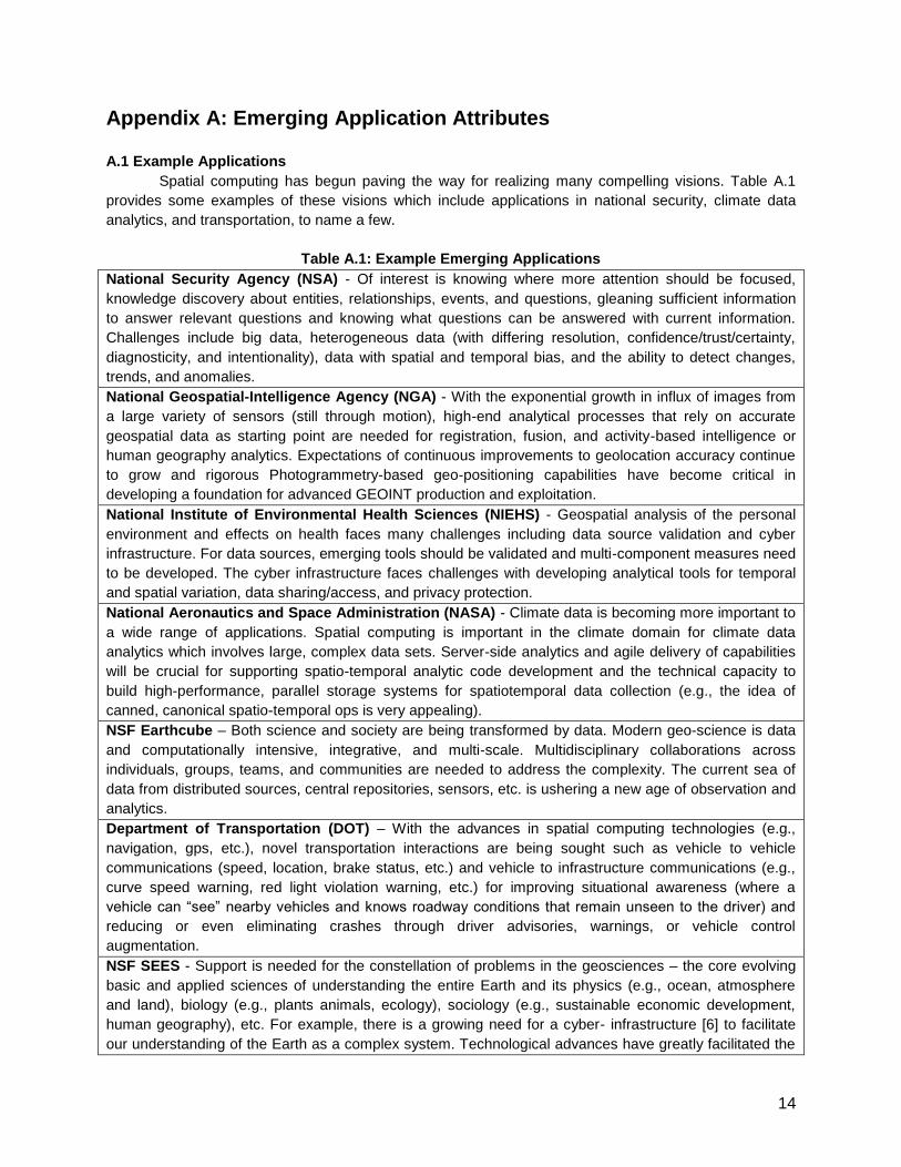
Spatial computing has begun paving the way for realizing many compelling visions. Table A.1
provides some examples of these visions which include applications in national security, climate data
analytics, and transportation, to name a few.
Table A.1: Example Emerging Applications
National Security Agency (NSA) - Of interest is knowing where more attention should be focused,
knowledge discovery about entities, relationships, events, and questions, gleaning sufficient information
to answer relevant questions and knowing what questions can be answered with current information.
Challenges include big data, heterogeneous data (with differing resolution, confidence/trust/certainty,
diagnosticity, and intentionality), data with spatial and temporal bias, and the ability to detect changes,
trends, and anomalies.
National Geospatial-Intelligence Agency (NGA) - With the exponential growth in influx of images from
a large variety of sensors (still through motion), high-end analytical processes that rely on accurate
geospatial data as starting point are needed for registration, fusion, and activity-based intelligence or
human geography analytics. Expectations of continuous improvements to geolocation accuracy continue
to grow and rigorous Photogrammetry-based geo-positioning capabilities have become critical in
developing a foundation for advanced GEOINT production and exploitation.
National Institute of Environmental Health Sciences (NIEHS) - Geospatial analysis of the personal
environment and effects on health faces many challenges including data source validation and cyber
infrastructure. For data sources, emerging tools should be validated and multi-component measures need
to be developed. The cyber infrastructure faces challenges with developing analytical tools for temporal
and spatial variation, data sharing/access, and privacy protection.
National Aeronautics and Space Administration (NASA) - Climate data is becoming more important to
a wide range of applications. Spatial computing is important in the climate domain for climate data
analytics which involves large, complex data sets. Server-side analytics and agile delivery of capabilities
will be crucial for supporting spatio-temporal analytic code development and the technical capacity to
build high-performance, parallel storage systems for spatiotemporal data collection (e.g., the idea of
canned, canonical spatio-temporal ops is very appealing).
NSF Earthcube – Both science and society are being transformed by data. Modern geo-science is data
and computationally intensive, integrative, and multi-scale. Multidisciplinary collaborations across
individuals, groups, teams, and communities are needed to address the complexity. The current sea of
data from distributed sources, central repositories, sensors, etc. is ushering a new age of observation and
analytics.
Department of Transportation (DOT) – With the advances in spatial computing technologies (e.g.,
navigation, gps, etc.), novel transportation interactions are being sought such as vehicle to vehicle
communications (speed, location, brake status, etc.) and vehicle to infrastructure communications (e.g.,
curve speed warning, red light violation warning, etc.) for improving situational awareness (where a
vehicle can “see” nearby vehicles and knows roadway conditions that remain unseen to the driver) and
reducing or even eliminating crashes through driver advisories, warnings, or vehicle control
augmentation.
NSF SEES - Support is needed for the constellation of problems in the geosciences – the core evolving
basic and applied sciences of understanding the entire Earth and its physics (e.g., ocean, atmosphere
and land), biology (e.g., plants animals, ecology), sociology (e.g., sustainable economic development,
human geography), etc. For example, there is a growing need for a cyber- infrastructure [6] to facilitate
our understanding of the Earth as a complex system. Technological advances have greatly facilitated the
15
collection of data (from the field or laboratory) and the simulation of Earth systems. This has resulted in
exponential growth of geosciences data and the dramatic increase in our ability to accommodate
complexity in models of Earth systems. These new data sources, referred to as Spatial Big Data, surpass
the capability of current spatial computing systems to process efficiently. New research into massively
scalable techniques for processing and mining Spatial Big Data via novel cyber-infrastructures will be key
for Geo-Informatics.
A.2 Cross-Agency Attributes of Spatial Use-cases
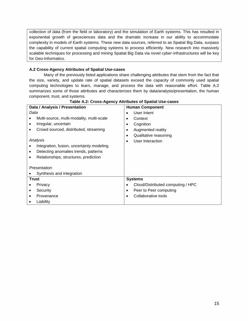
Many of the previously listed applications share challenging attributes that stem from the fact that
the size, variety, and update rate of spatial datasets exceed the capacity of commonly used spatial
computing technologies to learn, manage, and process the data with reasonable effort. Table A.2
summarizes some of those attributes and characterizes them by data/analysis/presentation, the human
component, trust, and systems.
Table A.2: Cross-Agency Attributes of Spatial Use-cases
Data / Analysis / Presentation
Data
Multi-source, multi-modality, multi-scale
Irregular, uncertain
Crowd sourced, distributed, streaming
Analysis
Integration, fusion, uncertainty modeling
Detecting anomalies trends, patterns
Relationships, structures, prediction
Presentation
Synthesis and integration
Human Component
User Intent
Context
Cognition
Augmented reality
Qualitative reasoning
User Interaction
Trust
Privacy
Security
Provenance
Liability
Systems
Cloud/Distributed computing / HPC
Peer to Peer computing
Collaborative tools
16
Appendix B: Emerging Platform Trends
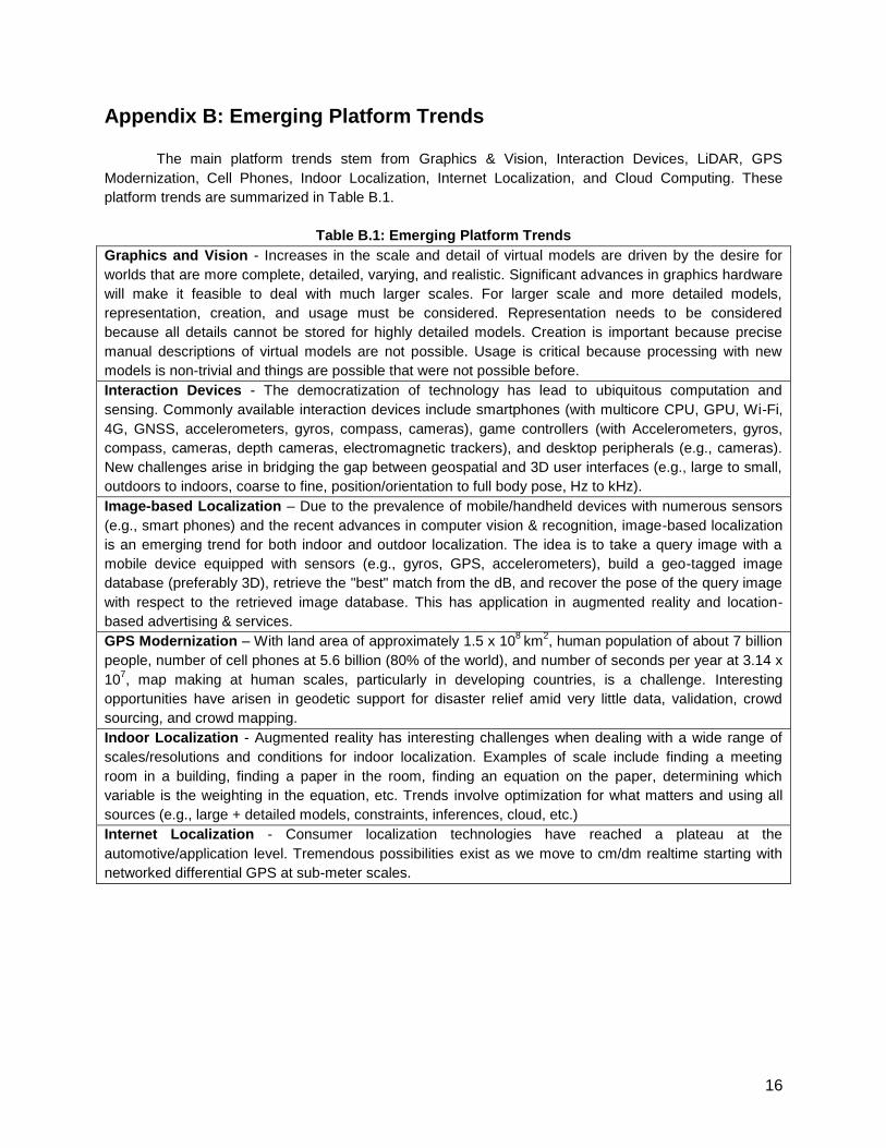
The main platform trends stem from Graphics & Vision, Interaction Devices, LiDAR, GPS
Modernization, Cell Phones, Indoor Localization, Internet Localization, and Cloud Computing. These
platform trends are summarized in Table B.1.
Table B.1: Emerging Platform Trends
Graphics and Vision - Increases in the scale and detail of virtual models are driven by the desire for
worlds that are more complete, detailed, varying, and realistic. Significant advances in graphics hardware
will make it feasible to deal with much larger scales. For larger scale and more detailed models,
representation, creation, and usage must be considered. Representation needs to be considered
because all details cannot be stored for highly detailed models. Creation is important because precise
manual descriptions of virtual models are not possible. Usage is critical because processing with new
models is non-trivial and things are possible that were not possible before.
Interaction Devices - The democratization of technology has lead to ubiquitous computation and
sensing. Commonly available interaction devices include smartphones (with multicore CPU, GPU, Wi-Fi,
4G, GNSS, accelerometers, gyros, compass, cameras), game controllers (with Accelerometers, gyros,
compass, cameras, depth cameras, electromagnetic trackers), and desktop peripherals (e.g., cameras).
New challenges arise in bridging the gap between geospatial and 3D user interfaces (e.g., large to small,
outdoors to indoors, coarse to fine, position/orientation to full body pose, Hz to kHz).
Image-based Localization – Due to the prevalence of mobile/handheld devices with numerous sensors
(e.g., smart phones) and the recent advances in computer vision & recognition, image-based localization
is an emerging trend for both indoor and outdoor localization. The idea is to take a query image with a
mobile device equipped with sensors (e.g., gyros, GPS, accelerometers), build a geo-tagged image
database (preferably 3D), retrieve the "best" match from the dB, and recover the pose of the query image
with respect to the retrieved image database. This has application in augmented reality and location-
based advertising & services.
GPS Modernization – With land area of approximately 1.5 x 10⁸
km2, human population of about 7 billion
people, number of cell phones at 5.6 billion (80% of the world), and number of seconds per year at 3.14 x
107, map making at human scales, particularly in developing countries, is a challenge. Interesting
opportunities have arisen in geodetic support for disaster relief amid very little data, validation, crowd
sourcing, and crowd mapping.
Indoor Localization - Augmented reality has interesting challenges when dealing with a wide range of
scales/resolutions and conditions for indoor localization. Examples of scale include finding a meeting
room in a building, finding a paper in the room, finding an equation on the paper, determining which
variable is the weighting in the equation, etc. Trends involve optimization for what matters and using all
sources (e.g., large + detailed models, constraints, inferences, cloud, etc.)
Internet Localization - Consumer localization technologies have reached a plateau at the
automotive/application level. Tremendous possibilities exist as we move to cm/dm realtime starting with
networked differential GPS at sub-meter scales.
17
Appendix C: Societal Context
Since the beginning of the 2000s, the oil market has undergone a major shift - raising the price of
gasoline in the United States by roughly a factor of three, severely straining the economy. The rise of
China’s economy signaled that the developing world was becoming an increasingly important consumer
of oil. Between 1998 and 2008, China accounted for a third of the growth in global oil demand. Its
consumption, which reached 8 million barrels a day, rose more than five times faster than the rest of the
world. As developing countries like China, India, Russia and Brazil grow their middle class, the demand
for oil and other resources (e.g., food, water) will grow much faster than supplies, straining our world in
many ways. According to the Happy Planet Index, if the developing nations across the world want to live
a western lifestyle, we will need 4.5 planets to sustain everyone [2]. This will make it critical to efficiently
manage Earth’s natural resources by addressing issues such as the following: How Is the Movement of
People, Goods, and Ideas Transforming the World? How Might We Better Observe, Analyze, and
Visualize a Changing World? [39]. Spatial Computing is a crucial aspect for aiding in management of
these resources. IBM began a project entitled Smarter Planet to do just that, aiming to increase efficiency
of energy and resource use by building ‘smarter’ cities [40]. In addition, ESRI is working to answer the
question, “How do we utilize spatio-temporal concepts to design sustainable places and alternative
futures?” via a new initiative called GeoDesign [5]. These systems can be used for monitoring a variety of
Earth resources (e.g., agriculture fields, fresh water lakes, etc.) and trends (e.g., deforestation, pollution,
etc.) for timely detection and management of problems such as impending crop failures and crop-stress
anywhere in the world. NSF GEO and OCI Directorates are developing research visions in this area
under the EarthCube initiative [43].
Eco-routing: Logistics companies such as UPS are exploiting smarter routing decisions (e.g., avoiding
left turns) to save over three million gallons of fuel and associated green house gas emissions annually
[31]. Imagine the savings in fuel-cost and greenhouse gases if other fleet owners (e.g., public
transportation) and consumers utilized this technology. GPS navigation services are just beginning to
experiment with providing eco-routes which aim to reduce fuel consumption, as compared to reducing
distance traveled, or time spent. The McKinsey Global Institute recently published a report estimating that
Smart Routing could have a global worth of “about $500 billion by 2020” in terms of fuel and time saved
[32]. These techniques along with smarter suggestions for ride sharing and public transportation will
enable significant fuel conservation. The rise of Spatial Big Data may enable computers to suggest not
only compatible ride-share partners, but they may lead to retooled bus routes based on the spatio-
temporal movements of individuals. With these new data sources, can we develop efficient and privacy-
preserving techniques to automatically suggest public transportation, compatible ride-share partners and
smart driving routes?
Relieve Air-Traffic Congestion: Current air-traffic control systems rely on radar. Due to the imprecision
of this technology, large gaps between aircraft are required to ensure safety and avoid collisions.
Consequently, the air space over America has become more and more congested, with the military
needing to open up reserved air space over holiday weekends. If air traffic control systems were switched
to a GPS-based system, the large gaps between aircraft would no longer be needed as the traffic
controllers would have much more precise data. The Federal Aviation Administration (FAA) is actively
exploring this vision to relieve congestion in many air corridors [13].
Increase Prosperity: The above mentioned McKinsey report states that location-based ser- vices will be
a significant portion of an estimated 150,000 new deep-analytical jobs and 1.5 million data-savvy
manager and analyst positions needed for the upcoming push by companies into big-data analysis [32].
18
Along with that, a potential consumer surplus of “$600 billion annually” is possible through using personal
location data. However, the use of geospatial information in commerce is in its infancy. Great
opportunities lay ahead in the leveraging of users’ locations and expected routes in proactive services
and assistance, ad impressions, and healthcare. Even though preliminary work in mobile commerce has
explored the potential of computers enhancing commerce between mobile buyers and businesses based
on geolocation [24], next generation bidding systems enabling ideal matches between mobile buyers and
sellers continue to pose challenging research questions such as the following: How can computer
systems efficiently pair mobile buyers and geo-located sellers while minimizing overall trip delay and
transportation costs? This vision involves many advances in the basic foundations of Spatial Computing,
and many new technologies. It also requires substantial continuing investments by the business
community, and potentially significant training and re-training of the human workforce.

19
Appendix D: Participants
Table D.1: List of Participants
Academia Industry & Non-Profit organizations Federal Agencies
Avideh Zakhor, University of California Berkeley
Mohamed Ali, Microsoft Beth Driver, NGA
Benjamin Kuipers, University of Michigan Ramon Caceres, AT&T Research Budhendra Bhaduri, ORNL
Cecilia Aragon, University of Washington Siva Ravada, Oracle Clifford Jacobs, NSF
Chuck Hansen, University of Utah Tom Erickson, IBM Eric Vessey, NSA
Craig A. Knoblock, Information Sciences Institute
Xuan Liu, IBM Tandy Warnow, NSF
Dan Keefe, University of Minnesota Jagan Sankaranarayanan, NEC Labs Farnam Jahanian, NSF
Daniel Z. Sui, Ohio State Lea Shanley, Wilson Center Howard D. Wactlar, NSF
Dev Oliver, University of Minnesota Mark Abrams, ESG / NRO Jim Shine, Army Geospatial Center
Dinesh Manocha, University of North Carolina
Lee Allison, Arizona Geological Survey
Kelly Crews, NSF
Edward M. Mikhail, Purdue Jade DePalacios, ESG/NRO Vijay Atluri, NSF
Greg Welch, University of North Carolina Virginia Bacon Talati, CSTB Li Zhu, NIH
Norman Sadeh, CMU Jon Eisenberg, CSTB Maria Zemankova, NSF
John Keyser, Texas A&M University Erwin Gianchandani, CCC Myron Gutmann, NSF
Paul Torrens, University of Maryland Eric Hoel, ESRI Nabil Adam, DHS
Jie Gao, Stony Brook University Susanne Hambrusch, NSF
May Yuan, University of Oklahoma Henry Kelly, OSTP
Michael Goodchild, University of California Santa Barbara
Keith Marzullo, NSF
Mike Worboys, University of Maine John L Schnase, NASA
Ouri E. Wolfson, University of Illinois at Chicago
Todd Johanesen, NGA
Peggy Agouris, George Mason University Walton Fehr, USDOT
Rajesh Gupta, University of California San Diego
Mark Weiss, NSF
Sara Graves, University of Alabama Huntsville
Michelle Heacock, NIH/NIEHS
Shaowen Wang, University of Illinois at Urbana-Champaign
Nicole Wayant, Army Geospatial Center
Shashi Shekhar, University of Minnesota Raju Vatsavai, ORNL
Stephen Hirtle, University of Pittsburgh
Steven Feiner, Columbia University
Divyakant Agrawal, University of California Santa Barbara
Vipin Kumar, University of Minnesota
Walid G. Aref, Purdue University
Chang-Tien Lu, Virginia Tech
Michael R. Evans, University of Minnesota
20
Appendix E: Representative Computer Science Questions
Sample Questions in SC Sciences
What are algorithm design paradigms for spatio-temporal problems which violate the dynamic
programming assumptions of stationary ranking of candidates?
What are components of spatial intelligence? Can computers have as much spatial intelligence as
humans? How can computational agents reason about qualitative and quantitative spatio-temporal
concepts and constraints?
How do humans represent and learn cognitive maps? What is impact of GPS devices on human
learning? What are implications, e.g., for evacuation (route) advisory?
How do we conceptualize spatio-temporal world for computing?
How do we measure spatio-temporal concepts, recognize them in remotely sensed information or in
the field, and identify their accuracy and quality?
How do we represent spatio-temporal concepts with incomplete/ uncertain information, with
alternative data models, and possibly with multiple representations for the same data, in digital
environments?
How do we explain spatio-temporal phenomena through the application of appropriate methods of
analysis, and models of physical and human processes?
How do we use spatio-temporal concepts to think about spatio-temporal phenomena, and to seek
explanations for spatio-temporal patterns and phenomena?
How may machine learning techniques be generalized to address spatio-temporal challenges of auto-
correlation, non-stationarity, heterogeneity, multi-scale, etc.?
What are scalable and numerically robust algorithms spatial statistical modeling?
How can data analytic models be generalized for spatio-temporal network data (e.g., crime reports in
cities) to identify patterns of urban life?
Sample Questions in SC Systems
What new SC opportunities arise from trends in sensors (e.g., LiDAR), sensor platforms (e.g., mobile
phones) and sensor networks (e.g., traffic, weather)?
For the best balance between performance and flexibility, what it the appropriate allocation of spatial
data-types and operations across hardware, assembly language, OS kernel, run-time systems,
network stack, database management systems, geographic information systems and application
programs?
Which spatio-temporal computations are hard to speed up with cloud computing? GPGPUs? multi-
core? Which benefit? Consider challenges of spatio-temporal graphs, streaming spatial data, load-
balancing and data partitioning.
How may one authenticate location of an Internet entity (e.g., client, server, packet) despite motion,
location-spoofing, physical trojan-horses, etc?
How may we reduce the semantic gap between spatio-temporal computations and primitives (e.g.,
ontology, taxonomies, abstract data-types) provided by current computing systems?
How do we store, access, and transform spatio-temporal concepts, facilitating data sharing, data
transfer, and data archiving, while ensuring minimum information loss? Consider challenges of spatio-
temporal graphs and streaming spatial data.
21
Sample Questions in SC Services
What augmentations to human capabilities can be provided by SC? Consider different scales (e.g.,
individuals, small groups and large communities). If appropriate use tasks, e.g., assisted geo-search
for missing person after a disaster or recent deforestation.
How do we create, communicate and interact with (2D & 3D) spatio-temporal information for
augmented reality? For scientific workflows, e.g., exploration of 3D volumes and their physical
properties?
How can an international SC system overcome geographic variance in language and cultural?
Understand spatial human interaction in small (e.g., proximal interactions) and large (crowd-sourcing,
flash-crowds). How geo-social groups form, how they are spatio-temporally organized, what are
spatio-temporal signature of group behaviors of interest?
How do we fuse disparate spatial data sources to understand a geographic phenomena or detect an
event, when it is not possible via study of a single data source?
How can we automate map creation similar to attempts in the database field to automate database
administration tasks (e.g., index building, etc)?
What SC challenges arise from the national scientific collaborations, e.g., EarthCube and IPCC?
Emergency maps production, e.g., OSM?
How do we utilize spatio-temporal concepts to design sustainable places and alternative futures?
Sample Cross-Cutting Questions
What can be mined from geo-social media logs, e.g., check-ins, mobile device trajectories, etc.? How
may one estimate evacuee population? Traffic speed and congestion? Urban patterns of life?
What is the SC impact of changing to a mobile ego-centric frame of reference from earth-centric
frame such as latitude, longitude, and latitude?
How may one overcome challenges of limited user attention, display, power, etc.?
If moving vehicles could talk to each other and humans, what would they talk about? What SC
challenges emerge?
How can one accurately determine location (and orientation) of mobile clients in GPS-denied spaces
such as indoors or underground?
What are sources of errors and uncertainties in spatial datasets and analysis? How may the errors
and uncertainties be controlled or reduced? How to remedy data biases, under- or over-sampling ?
How may one communicate spatio-temporal datasets with uncertainties in location, time and
attributes in different modes, e.g., visual ?
When does localization (e.g., GPS-tracking) lead to privacy violation? Is reducing spatio-temporal
resolution sufficient to discourage stalking and other forms of geo-slavery?
How can one characterize trade-off between privacy and utility of spatio-temporal data? How may
societal needs (e.g., tracking infectitious disease) be served?
How should scale be addressed, how should data be organized (by layer, by feature type, etc.), and
how should it be indexed for rapid search?
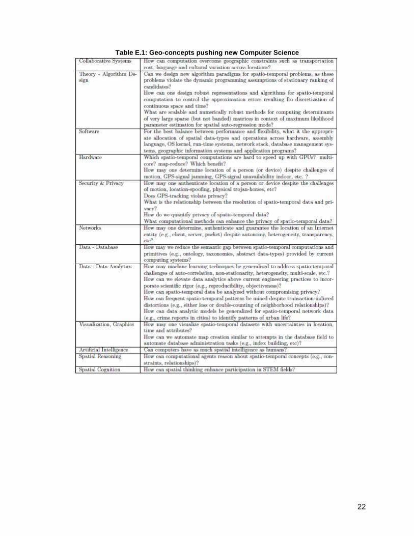
22
Table E.1: Geo-concepts pushing new Computer Science
23
References
[1] Department of Transportation. Connected Vehicle Technology Challenge. http://goo.gl/fP8nd, 2011.
[2] S. Abdallah, S. Thompson, J. Michaelson, N. Marks, N. Steuer, et al. The Happy Planet Index 2.0:
Why good lives dont have to cost the Earth. London: nef (the new economics foundation), 2009.
[3] Advances in Spatial and Temporal Databases: 12th International Symposium, SSTD 2011. Challenge
and Vision Track. Springer. http://sstd2011.cs.umn.edu/, 2011. LNCS 6849.
[4] A. AH, G. SY, M. C, and D. R. AV. A review of spatial methods in epidemiology, 2000-2010. Annual
review of public health, 33:107{22, 2012.
[5] ArcWatch. Designing GeoDesign. http://goo.gl/j31OV, 2011.
[6] D. Atkins. Revolutionizing science and engineering through cyberinfrastructure: Report of the national
science foundation blue-ribbon advisory panel on cyberinfrastructure. 2003.
[7] J. Bruder. In Groupons $6 Billion Wake, a Fleet of Start-Ups. http://goo.gl/bO0Er, 2011. NY Times.
[8] CCC. Discovery and Innovation in Health IT. http://cra.org/ccc/healthit.php, 2009.
[9] J. Clapper. Geospatial-intelligence basic doctrine. National Geospatial Intelligence Agency, 2004.
[10] J. Dobson and P. Fisher. Geoslavery. Technology and Society Magazine, IEEE, 22(1):47{52, 2003.
[11] D. M. Ewalt. Google is everywhere. http://goo.gl/U7iJC, 2005. Forbes.
[12] M. Faulkner, M. Olson, R. Chandy, J. Krause, K. Chandy, and A. Krause. The next big one: Detecting
earthquakes and other rare events from community-based sensors. In Information Processing in
Sensor Networks (IPSN), 2011 10th International Conference on, pages 13{24. IEEE, 2011.
[13] Federal Aviation Administration. Next Generation Air Transportation System. http://goo.gl/Xme87.
[14] Federal Highway Administration. IntelliDrive: Safer. Smarter. Greener. http://goo.gl/54rBe, 2011.
Publication Number: FHWA-HRT-10-004.
[15] P. Folger. Geospatial information and geographic information systems (GIS): Current issues and
future challenges. DIANE Publishing, 2010. Congressional Research Service.
[16] V. Gewin. Mapping opportunities. Nature, 427(6972):376{377, 2004.
[17] E. Gianchandani. SSTD 2011 Vision & Challenge Track Winners Announced. http://goo.gl/ercG6,
2011. The Computing Community Consortium Blog.
[18] A. Gore. The digital earth: Understanding our planet in the 21st century, given at the california
science center, los angeles, california, on january 31, 1998.
[19] V. Gunturi, E. Nunes, K. Yang, and S. Shekhar. A critical-time-point approach to all-start-time
lagrangian shortest paths: a summary of results. Proc. SSTD, 2011.
[20] L. Hornby. China unveils its own version of google earth. http://goo.gl/JzE2W, 2010. Reuters.
[21] Inside GNSS. GNSS Systems Reports. http://goo.gl/uh8f4, 2011.
[22] Institute of Navigation. http://goo.gl/quqSX.
[23] E. F. Jerome C. Glenn, Theodore J. Gordon. State of the Future. The Millennium Project, 2011.
[24] E. Kamar, E. Horvitz, and C. Meek. Mobile opportunistic commerce: mechanisms, architecture, and
application. In Proc. Intl. Conf. on Autonomous agents and multiagent systems-Volume 2, pages
1087{1094. International Foundation for Autonomous Agents and Multiagent Systems, 2008.
[25] A. S. Kathryn Zickuhr. 28% of american adults use mobile and social location-based services.
http://goo.gl/atyd8, 2011. Pew Internet.
[26] J. L. Ki-Joune Li. Indoor spatial awareness initiative and standard for indoor spatial data.
Proceedings of IROS 2010 Workshop on Standardization for Service Robot, 2010. Taiwan.
[27] A. Krause, E. Horvitz, A. Kansal, and F. Zhao. Toward community sensing. In Proc. Intl. Conf.
Information processing in sensor networks, pages 481{492. IEEE Computer Society, 2008.
[28] J. Krumm. A survey of computational location privacy. Personal and Ubiquitous Computing,
13(6):391{399, 2009.
24
[29] G. Lindsay. Cisco's big bet on new songdo: Creating cities from scratch. http://goo.gl/2huIc, 2010.
[30] P. Lioy and S. Rappaport. Exposure science and the exposome: an opportunity for coherence in the
environmental health sciences. Environmental health perspectives, 119(11):a466, 2011.
[31] J. Lovell. Left-hand-turn elimination. http://goo.gl/3bkPb, 2007. New York Times.
[32] J. Manyika et al. Big data: The next frontier for innovation, competition and productivity. McKinsey
Global Institute, May, 2011.
[33] R. McMaster and E. Usery. A research agenda for geographic information science, volume 3. CRC
Press, 2005. University Consortium for Geographic Information Science.
[34] National Institutes of Health (NIH). Spatial Uncertainty: Data, Modeling, and Communication (R01).
http://grants.nih.gov/grants/guide/pa-files/PA-11-238.html, 2011.
[35] National Research Council. IT roadmap to a geospatial future. National Academies Press, 2003.
[36] National Research Council. Priorities for GEOINT research at the National geospatial-intelligence
agency. National Academies Press, 2006. ISBN: 9780309101493.
[37] National Research Council. Successful Response Starts with a Map: Improving Geospatial Support
for Disaster Management. National Academies Press, 2007. ISBN: 0309103401 / 0-309-10340-1.
[38] National Research Council. New Research Directions for the National Geospatial-Intelligence
Agency. National Academies Press, 2010. ISBN: 0309158656 / 0-309-15865-6.
[39] National Research Council. Understanding the changing planet: Strategic directions for the
geographical sciences. National Academies Press, 2010. ISBN: 9780309150750.
[40] New York Times. IBM Starts to Build Greener, 'Smarter' Planet in Iowa. http://goo.gl/BhGZu, 2009.
[41] New York Times. Digital Help for Haiti. http://goo.gl/yYn66, 2010.
[42] New York Times. Justices Say GPS Tracker Violated Privacy Rights. http://www.nytimes.com/2012/
01/24/us/police-use-of-gps-is-ruled-unconstitutional.html, 2011.
[43] NSF. Earth Cube. http://www.nsf.gov/geo/earthcube/, 2011.
[44] Office of Management and Budget. Coordination of Geographic Information and Related Spatial Data
Activities. http://goo.gl/9n5tm, 2010.
[45] D. Oliver and D. Steinberger. From geography to medicine: exploring innerspace via spatial and
temporal databases. Advances in Spatial and Temporal Databases, pages 467{470, 2011.
[46] L. Pickle, M. Szczur, D. Lewis, and D. Stinchcomb. The crossroads of gis and health information: a
workshop on developing a research agenda to improve cancer control. International journal of
health geographics, 5(1):51, 2006.
[47] S. Rappaport. Implications of the exposome for exposure science. Journal of Exposure Science and
Environmental Epidemiology, 21(1):5{9, 2010.
[48] J. Schiller and A. Voisard. Location-based services. Morgan Kaufmann, 2004.
[49] S. Shekhar, M. R. Evans, J. M. Kang, and P. Mohan. Identifying patterns in spatial information: A
survey of methods. Wiley Interdisc. Rew.: Data Mining and Know. Discovery, 1(3):193{214, 2011.
[50] S. Shekhar and H. Xiong. Encyclopedia of GIS. Springer, New York, 2008.
[51] Y. Thomas, D. Richardson, and I. Cheung. Geography and drug addiction. Springer Verlag, 2009.
[52] United States Air Force. GPS III. 2011.
(http://www.losangeles.af.mil/library/factsheets/factsheet.asp?id=18830)
[53] Waze Mobile. http://www.waze.com/.
[54] Wikipedia. Google goggles|wikipedia, the free encyclopedia, 2012. [Online; accessed 20-August-
2012].
[55] T. Yuan and W. Kuo. Spatial defect pattern recognition on semiconductor wafers using model-based
clustering and bayesian inference. European Jr. of Operational Research, 190(1):228{240, 2008.
Recommended