Copyright © ESB International Limited, all rights reserved.
ESB International, Stephen Court, 18/21 St Stephen’s Green, Dublin 2, Ireland.
Phone +353 (0)1 703 8000
www.esbi.ie
Gearagh Scoping Exercise
Scoping Report
ESB GWM
Document No.: QD-000223-01-R101-000
Date: February 2017

QD-000223-01-R101-000 2
File Reference: QD-000223
Client / Recipient:
ESB GWM
Project Title: Gearagh Scoping Exercise
Report Title: Scoping Report
Report No.: QD-000223-01-R101-000
Volume: 1 of 1
Prepared by: Geoff Hamilton Date: 10/02/2017
Title: Ecologist
Verified by: Jim Fitzpatrick Date: 20/02/2017
Title: Senior Consultant
Approved by: Roisin O’Donovan Date: 21/02/2017
Title: Senior Consultant
Copyright © ESB International Limited
All rights reserved. No part of this work may be modified, reproduced or copied in any form
or by any means - graphic, electronic or mechanical, including photocopying, recording,
taping or used for any purpose other than its designated purpose, without the written
permission of ESBI Engineering & Facility Management Ltd., trading as ESB International.
Template Used: T-020-007-ESBI Report Template
Change History of Report
Date New Revision Author Summary of Change
Gearagh Scoping Exercise Scoping Report
QD-000223-01-R101-000 3
Contents
1 Introduction 4
1.1 Context of Scoping Exercise 4
1.2 Acknowledgements 6
2 Literature Review 7
2.1 Scope of literature review 7
2.2 Anastomosing river systems 7
2.3 Classification of woodland types 8
2.4 History of The Gearagh 10
2.5 Development of the Carrigadrohid Reservoir 14
2.6 Ecological value of Carrigadrohid reservoir 16
2.7 Ecology of The Gearagh woodland 17
2.8 Influences on The Gearagh woodland post-reservoir
development 19
3 Data Collation and Mapping 31
3.1 Data sourcing 31
3.2 Mapping 32
4 Site Assessment 33
5 Recommendations 36
5.1 Basis of recommendations 36
5.2 Gearagh Woodland Management Plan 36
5.3 Toon Sub-catchment Monitoring Regime 39
5.4 Period of monitoring 40
5.5 Output data usage - Fluvial geomorphological
assessment 40
5.6 Conclusion 40
6 References & Bibliography 41
Appendix 1 – Correspondence relating to 1983/84 events
Appendix 2 – Conservation Objectives
Appendix 3 – Site Photographs
Appendix 4 – Mapping
Appendix 5 – Report of site inspection, 15th April 2015

Gearagh Scoping Exercise Scoping Report
QD-000223-01-R101-000 4
1 Introduction
1.1 Context of Scoping Exercise
The ESB property boundary for Carrigadrohid Reservoir, Co. Cork, incorporates two
Natura 2000 sites (one Special Area of Conservation (SAC) and one Special
Protection Area (SPA)) associated with ‘The Gearagh’ at the western extent of the
waterbody. One of the main qualifying features of the SAC at The Gearagh is the
area of alluvial woodland (a priority habitat) along the Toon River, downstream of
Toon Bridge, where it enters probably the best of the very few examples of an
anastomosing lowland forested river in north-west Europe; the woodland also
extends to the south, along the course of the River Lee. The second Natura 2000
site, The Gearagh Special Protection Area (SPA) overlaps to a large degree with the
SAC.
A complaint has been lodged with the European Commission relating to concerns
over potential erosion within the alluvial woodland downstream of Toon Bridge at the
western extent of the SAC. The complaint relates to whether purported increased
spate loads (increased hydrographic peaks) on the Toon River itself are leading to
increased levels of bank and riverbed erosion along the Toom River within the alluvial
forest, to the detriment of the anastomosing system, and whether this is leading to
(a) erosion and loss of islands in the Toon part of the system, and (b) isolation and
drying of diversion channels.
A key feature of anastomosis is the occurrence of erosion resistant banks and stable
channels (unlike braided rivers). The complaint focuses on whether these are being
eroded by human-influenced activities in the Toon River floodplain upstream, and
whether future surface drainage for wind-farms, such as the Cleanrath wind-farm
(recently granted permission by An Bord Pleanála (PL04.240801) will contribute to
this in the future.
Arising from the complaint, the Commission initiated a Pilot Infringement Case
against Ireland (Ref: 5450/13). Additionally, a separate petition to the European
Parliament was also made by the same complainant (ref: 1056/2013).
The Department of Arts Heritage and the Gaeltacht submitted a written response to
the Commission, with input from the Department of Environment, Community and
Local Government and Cork County Council in April 2015. This response concluded
that the best course of action would be to form a small working group to consider
whether there would be merit in having further analysis carried out with a view to
developing the potential of the area as a nature reserve, conservation demonstration
project and tourism asset.
A provisional site visit along the affected stretch of the Toon River was carried out by
representatives of the Department of the Environment, Community and Local
Government (DECLG) and National Parks and Wildlife Services (NPWS – which is
under the aegis of the Department of Arts Heritage and the Gaeltacht) on the 15th
April 2015. Arising from this visit, the DECLG representative noted that “causality
between the evolution of local land use patterns and what may or may not be
happening to the catchment cannot be proven on the basis of the evidence presented
Gearagh Scoping Exercise Scoping Report
QD-000223-01-R101-000 5
by [the complainant]”. The NPWS representative recommended that a fluvial
geomorphological assessment of possible changes in the Toon River part of The
Gearagh system be carried out. A copy of the report of DECLG and NPWS following
the site visit is enclosed in Appendix 5.
As previously described, a separate petition to the European Parliament was made
by the same complainant (ref: 1056/2013), who directly addressed the EP Petitions
Committee on September 8th 2016. A European Commission representative also
addressed the Committee, noting the engagement undertaken by the Commission
with the Irish Government to date.
As part of an initial response to the Commission case, the Department of Housing,
Planning and Local Government (DHPCLG, formerly DECLG) convened a working
group of key stakeholders for The Gearagh site, comprising representatives from
DHPCLG, Cork County Council, NPWS and ESB/ESB International.
This group held a meeting on June 7th 2016 to discuss next steps and outline
deliverables relating to the provision of a response to the Commission and also to
assess constraints and options for the long-term management of The Gearagh
woodland.
Arising from this meeting, it was agreed that to facilitate the above, an initial scoping
exercise was required to identify the pressures on the Toon River upstream of the
apparent erosion location and to define the extent of morphology, hydrology and
ecology surveys which may subsequently be required along the Toon River and
within the alluvial woodland of The Gearagh. It was agreed that ESB International
would be responsible for carrying out this scoping exercise on behalf of ESB, which
would be presented to the working group following the publication of the
Conservation Objectives of The Gearagh SAC.
The scoping exercise included:
A literature review of all relevant published and accessible un-published
material relating to The Gearagh woodland and Toon River catchment.
The collation of datasets containing relevant environmental, hydrological,
geological, morphological and land use/management data, and their
incorporation into a Geographic Information System (GIS) geodatabase.
Consultation with key stakeholders as well as individuals with a particular
interest in the site, including the original complainant and local landowners.
Preliminary hydrology, morphology and ecology walkover surveys to facilitate
geographical targeting of surveys subsequent to the scoping stage.
Recommendations for further surveying and next steps in relation to site
monitoring and possible restoration.
This report presents the results of the scoping exercise.

Gearagh Scoping Exercise Scoping Report
QD-000223-01-R101-000 6
1.2 Acknowledgements
The authors of this report wish to acknowledge the assistance of the members of the
Project Steering Group, comprising representatives of:
Department of Housing, Planning, Community and Local Government
National Parks and Wildlife Service
Cork County Council
Electricity Supply Board
The following parties were also engaged with as part of informal consultation, during
site visits or as a result of the data gathering exercise. The authors wish to thank
them all for their time and valuable input.
Kevin Corcoran, West Cork Ecology Centre
Daniel Kelly, Trinity College Dublin
Conor O’Malley, National Parks and Wildlife Service
Jervis Good, National Parks and Wildlife Service
Simon Harrison, University College Cork
Mary O’Connor, Independent Ecologist
Peter Barry, Malachy Walsh & Partners
Michael Gill, Hydro-Environmental Services
John Martin, Office of Public Works
Michael Ward, Ordnance Survey Ireland
Tony Brown, University of Southampton
Dermot Horgan, Local Landowner
Sean Ó Lionard, Local Landowner
Declan O’Mahony, Independent Film Director
Gearagh Scoping Exercise Scoping Report
QD-000223-01-R101-000 7
2 Literature Review
2.1 Scope of literature review
This literature review is divided into a number of sections, the first two of which aim
to summarise the key aspects of the ecological and hydrological functioning of a
wooded anastomosing river system as present at The Gearagh. The remaining
sections present a summary of land use (and land use change) within the site and in
its general locality.
The review therefore facilitated the rest of the scoping exercise by placing the
available empirical data, consultation feedback and site survey findings in the context
of the best available background information relating to The Gearagh and its
constituent habitats.
2.2 Anastomosing river systems
The following section is a summary of the findings of Makaske (2001) in his overview
paper “Anastomosing rivers: a review of their classification, origin and sedimentary
products”.
Anastomosing rivers constitute an important category of multi-channel rivers on
alluvial plains. Most often they seem to form under relatively low-energetic flow
conditions. A recent review of the geomorphology of these rivers now defines the
anastomosing river as composed of two or more interconnected channels that
enclose flood-basins.
Anastomosing rivers are usually formed by avulsions, i.e., flow diversions that cause
the formation of new channels on the floodplain.
As a product of avulsion, anastomosing rivers essentially form in two ways: by
formation of bypasses, whereby bypassed older channel-belt segments remain
active for some period; and by splitting of the diverted avulsive flow, leading to
contemporaneous scour of multiple channels on the floodplain. Both types of
anastomosis may coexist in one river system, but whereas the first may be a long-
lived floodplain-wide phenomenon, the latter only represents a stage in the avulsion
process on a restricted part of the floodplain.
Anastomosing Rivers:
Often have saucer shaped islands;
Often have channels with high sinuosity;
Comprise channels which are often much narrower than intervening
islands formed;
Have angles of bifurcation of channels wider (often at obtuse and right
angles) than in braided rivers (usually at acute angles);
Occupy ‘floodbasins’ which are flat, shallow, poorly drained floodplain
depressions bounded by natural levees of active or abandoned channels
or other uplands;
Gearagh Scoping Exercise Scoping Report
QD-000223-01-R101-000 8
Are classified as a composite form of a river system which may be
comprised of multiple channel belts. The individual channel belts may
have braided, meandering or straight channel areas.
The geomorphological processes in anastomosing rivers are of two kinds: the
processes creating the pattern of multiple channel belts, i.e. the processes
associated with avulsion, and the processes determining the morphology of the
individual channel belts of the system. In many different ways, climate and geology
are important external controls of these processes.
Frequent avulsions and/or slow abandonment of old channels lead to continuing
coexistence of younger deepening channels and old vertically infilling channels,
composing an anastomosing system at any given moment in time. The question here
is whether all rivers naturally strive for a single channel belt, and if so, which
conditions prevent them from reaching that state, thereby causing long-lived
anastomosis as is the case with The Gearagh.
With respect to avulsion frequency, anastomosing rivers range from highly dynamic
to semi-static. In semi-static systems, anastomosis seems to result mainly from
extremely slow infilling of old channels after infrequent formation of new channels. In
more dynamic systems, anastomosis rather results from the frequent formation of
new channels, while old channels remain active for some time.
A rapid rise of river bed level is conducive to anastomosis, but is not a necessary
condition. Some extensive anastomosing river systems apparently exist in
equilibrium with stable external conditions. The often-observed high lateral stability
of individual channels in anastomosing rivers is caused by low stream power in
combination with resistant banks. Both conditions are strongly related to a low
floodplain gradient.
With respect to genesis and lifetime, four basic types of anastomosing rivers can be
identified: short-lived anastomosis within an avulsion belt; short-lived, transitional
anastomosis during a single avulsion, due to temporary coexistence of an older trunk
channel and a new avulsion channel; long-lived, highly dynamic anastomosing
systems, constantly rejuvenated by frequent avulsions caused by allogenic controls;
and long-lived, semi-static anastomosing systems, which seem in equilibrium with
stable external conditions. Since these four types are morphologically quite similar,
anastomosing rivers can be considered an example of equifinality, i.e., different
combinations of processes or causes produce a similar form.
2.3 Classification of woodland types
2.3.1 Ancient and secondary woodland
Perrin et al. (2008) defines ‘ancient woodland’ as areas of the countryside that have
had continuous woodland cover since before planting and afforestation became
common practices. These sites are thus more likely to have natural origins and may
form a link with the prehistoric wildwood that once covered much of Europe
(Rackham, 1980), although all are likely to have been managed at some time, and
may bear little resemblance to the original forest cover.
Gearagh Scoping Exercise Scoping Report
QD-000223-01-R101-000 9
Cudmore (2012) follows a somewhat alternative approach, wherein ‘ancient
woodlands’ are generally defined as those that have been continuously wooded since
at least the oldest available historical data. By contrast, ‘secondary woodlands’ are
those woodlands that have established since that date on sites that had previously
been used for agriculture. For this purpose, Cudmore’s use of the term ‘ancient
woodland’ refers to sites that have not been used for agriculture since the threshold
date of 1650, which is when the first comprehensive survey (the ‘Civil’ survey) of Irish
land took place. Secondary woodlands are defined by Cudmore as those established
naturally within the past 200 years. As The Gearagh formed the primary component
of Cudmore’s 2012 thesis, her definition of ancient and secondary woodland will be
utilised as part of this scoping exercise for consistency.
Ancient woodlands also often contain communities of plants and animals that are
rarely found in more disturbed, secondary woodland or plantations (Hermy et al.,
1999). Extant areas of ancient woodland are therefore important sites for the
conservation of these species both as refugia and as a source of colonists for new
habitats (Goldberg et al., 2007). Although ancient woodlands have a history of
continuous tree cover, many have been subject to a range of management practices
in the past. Indeed, exploitation is an integral part of the history of most woodlands,
and so present-day ancient woods are often highly varied in structure and
composition (Rackham, 1980).
Only 123 stands of ancient woodland still remain in the Republic of Ireland (Perrin
and Daly, 2010), and 1,033 hectares in Northern Ireland (Anon., 2007); this
corresponds to approximately 10% of all native woodland sites across the whole
island or just 0.1% of the total land cover.
2.3.2 Alluvial woodland
The term ‘alluvial woodland’ covers a suite of habitat types. A relatively generic
definition of alluvial woodland from the European Commission (2007) states that all
types of alluvial woodland occur on heavy soils that are periodically inundated by the
annual rise of river levels, but that are otherwise well drained and aerated during low
water. Such woodland is a priority Annex I habitat (Code 91E0). A number of variants
of this habitat exist, of which riparian forests of Fraxinus excelsior and Alnus glutinosa
(Alno-Padion) of temperate and Boreal Europe lowland and hill watercourses are the
most common type to be found in Ireland. These occur on heavy soils which are
periodically inundated by the annual rise of river levels, but which are otherwise well
drained and aerated during low water. The herbaceous layer includes many large
species such as Filipendula ulmaria, Angelica sylvestris and Carex acutiformis,
vernal species such as Ranunculus ficaria and Anemone nemorosa, and other
indicative species such as Carex remota, Lycopus europaeus, Urtica dioica and
Geum rivale are also listed. Woodland in The Gearagh falls into this classification.
In addition there are gallery forests of tall willows (Salicion albae) alongside river
channels and occasionally on river islands, where the tree roots are almost
continuously submerged. They are dominated by Salix alba, S. viminalis and S.
triandra, sometimes with S. cinerea but alder is relatively rare. There is usually a
Gearagh Scoping Exercise Scoping Report
QD-000223-01-R101-000 10
luxuriant herb layer comprising, amongst others, Phalaris arundinacea, Urtica dioica
and Filipendula ulmaria.
A functioning alluvial forest with a good structure is a multi-layered system, although
the individual layers may be less distinct than in oak woods. Non-native species
should be no more than occasional, with a cover not exceeding 10%, and preferably
absent, although an exception is made for gallery woodlands in which non-native
species of willow may be frequent. Alluvial woodlands should have a good
complement of dead wood, including coarse and fine, standing and fallen dead wood,
to accommodate the greatest possible range of invertebrates and other saproxylic
organisms.
2.4 History of The Gearagh
The present-day ecology of The Gearagh site is strongly influenced by its historic
land use. While portions of the central parts of the site are likely to have remained
relatively un-impinged by human activities, other peripheral areas have been subject
to different management regimes. Cudmore’s (2012) thesis outlines in great detail
the changes which are likely to have occurred in and around the woodland, a tabular
summary of which is presented here.
Table 2.1 – Timeline of woodland development and change at The Gearagh
Early post-glacial period
(11,000 – 7,000 BC)
(Based on general successional habitat change in Ireland)
Some open grassland, tundra and low alpine scrub.
Juniper scrub progressively replaces meadows.
Arrival of willows and birch, replacing Juniper and leading to open woodland.
Hazel replace birch, with arrival of pine leading to reduction in hazel.
Oak and elm arrive, out-competing pine on lower more fertile soils.
Successive diversification of forests, to include other plant species.
Mesolithic period
(7,000 - 4,200 BC)
(Based on general successional habitat change in Ireland)
Alder arrived late to the south-west of Ireland, approximately
5,000 BC (Mighall et al., 2008). This tree is tolerant of moist
soils and so was able to out-compete pine on poorly-drained
sites.
However, pine would have still been found on the more acidic
soils, amidst a canopy of elm, oak and hazel.
No agriculture in Ireland – Forest cover reaches maximum.
Neolithic period
(4,200 - 2,000 BC)
Elm declines (most likely due to pandemic disease possibly
initiated or exacerbated by humans)
Neolithic farmers clear woodland on a limited scale, extending
in from coasts. Secondary woodlands with more ash.
Gearagh Scoping Exercise Scoping Report
QD-000223-01-R101-000 11
Minimal Neolithic archaeological evidence from Gearagh
indicates that such clearance unlikely here.
Bronze Age (2,000 - 500
BC)
Expansion of grassland and arable land, loss of pine from
country, replaced by oak, alder and hazel.
Blanket and raised bogs expand.
Archaeological evidence (including stone circles) highlights
human presence around Gearagh; likely that some woodland
clearance takes place with secondary woodland establishing.
Iron Age (500 BC - 500
AD)
Decline in agriculture possibly due to deteriorating climate;
woodland re-establishes in abandoned areas (hazel, birch
and ash).
Late Iron Age expansion in agricultural clearance again
probably limited close to The Gearagh, and in south-west
Ireland as a whole (minimal archaeological evidence of Iron
Age settlements etc.)
Early Medieval period
(500 - 1000)
Woodland resources for settled populations (in ringforts etc.)
are limited (tracts of land under Brehon law); coppicing of
understories becomes commonplace, with large trees
allowed to reach maturity for structural timber.
Inaccessibility of The Gearagh would have limited its value as
a wood/timber resource.
Late Medieval period
(1000 - 1650)
Deteriorating climate, invasions, famine, and the Black Death
resulted in economic decline and an overall decrease in the
population of the country; lack of exploitation leads to
increased density of existing woodlands.
The Gearagh lies within lands of MacCarthy and therefore
escapes exploitation by English settlers.
Stuart and Cromwellian
plantations (1650 –
1842)
National woodland cover likely to be less than 3%, though
Cork likely to have reached almost 6%. The majority of
woodlands were dominated by a mixture of Betula, Corylus,
Alnus, and Quercus.
Areas without significant ironworks, such as the upper Lee
Valley, received little investment in infrastructure. The only
significant threat to The Gearagh is therefore likely to have
come from agriculture.
In 1694, however, the fourth Earl of Clancarty forfeited his
lands (Ó Murchadha, 1993), and the new owners immediately
felled any standing timber for additional funds (Dickson,
2005). Cleared areas used for cattle and sheep grazing.
It is likely that The Gearagh survived as a scrub woodland,
although the margins were undoubtedly altered by
exploitation and agricultural encroachment.
Drainage of the land surrounding the River Lee was
attempted in the late 1700s. However, these efforts proved
difficult to maintain and were subsequently abandoned. This
Gearagh Scoping Exercise Scoping Report
QD-000223-01-R101-000 12
unsuccessful attempt to drain and channelise the River Lee
meant that The Gearagh remained relatively unaltered during
this period of increased exploitation and land improvement.
Post-famine, it is likely that cleared parts of The Gearagh
used for marginal grazing were abandoned.
1842 – 1904 The Ordnance Survey (OS) map of 1842 delineates key
morphological features of The Gearagh for the first time. It
shows that the southern part of The Gearagh, which was still
mostly wooded, was divided into the townlands of Gearagh
West and Gearagh East.
Much of the land around The Gearagh was still liable to
flooding; many abandoned channels can be seen to the south
of The Gearagh in the area of Annahala East and Annahala
West, denoting the former extent of the anastomosing
woodland system. These areas were marked ‘Liable to
Floods’.
Dairying one of the most important agricultural activities at this
time and a new creamery had been established in Teergay
just south of Toon Bridge.
During this period, abandoned areas of along the north of The
Gearagh revert to scrub and young woodland (e.g. Ilaunmore
islands), as seen in the 1904 second edition OS map.
1904 – 1955 Areas of The Gearagh which had been grassland in 1842 and
scrub in 1904, are now shown on Ordnance Survey maps as
mature woodland. Indeed, most islands had reverted to
woodland or at least to scrub by the time of the 1938 map
revision (see Appendix 4).
Botanical interest in site increases with a number of flora
surveys taking place.
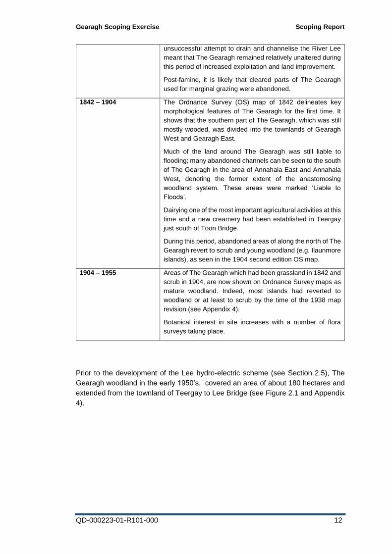
Prior to the development of the Lee hydro-electric scheme (see Section 2.5), The
Gearagh woodland in the early 1950’s, covered an area of about 180 hectares and
extended from the townland of Teergay to Lee Bridge (see Figure 2.1 and Appendix
4).
Gearagh Scoping Exercise Scoping Report
QD-000223-01-R101-000 13
Figure 2.1: Extent of The Gearagh woodland in 1938, approximately 180
hectares (Ordnance Survey 1:10,560 mapping background)
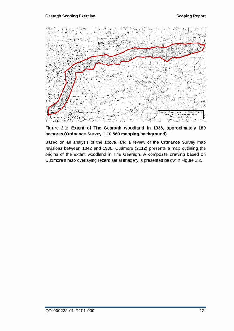
Based on an analysis of the above, and a review of the Ordnance Survey map
revisions between 1842 and 1938, Cudmore (2012) presents a map outlining the
origins of the extant woodland in The Gearagh. A composite drawing based on
Cudmore’s map overlaying recent aerial imagery is presented below in Figure 2.2.
Gearagh Scoping Exercise Scoping Report
QD-000223-01-R101-000 14
Figure 2.2: Origins of extant alluvial woodland at The Gearagh (based on
Cudmore, 2012)
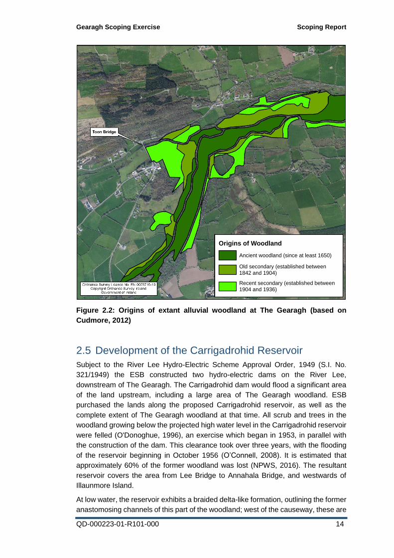
2.5 Development of the Carrigadrohid Reservoir
Subject to the River Lee Hydro-Electric Scheme Approval Order, 1949 (S.I. No.
321/1949) the ESB constructed two hydro-electric dams on the River Lee,
downstream of The Gearagh. The Carrigadrohid dam would flood a significant area
of the land upstream, including a large area of The Gearagh woodland. ESB
purchased the lands along the proposed Carrigadrohid reservoir, as well as the
complete extent of The Gearagh woodland at that time. All scrub and trees in the
woodland growing below the projected high water level in the Carrigadrohid reservoir
were felled (O'Donoghue, 1996), an exercise which began in 1953, in parallel with
the construction of the dam. This clearance took over three years, with the flooding
of the reservoir beginning in October 1956 (O’Connell, 2008). It is estimated that
approximately 60% of the former woodland was lost (NPWS, 2016). The resultant
reservoir covers the area from Lee Bridge to Annahala Bridge, and westwards of
Illaunmore Island.
At low water, the reservoir exhibits a braided delta-like formation, outlining the former
anastomosing channels of this part of the woodland; west of the causeway, these are
Legend
Origins of Woodland
Ancient woodland (since at least 1650)
Old secondary (established between1842 and 1904)
Recent secondary (established between1904 and 1936)
Gearagh Scoping Exercise Scoping Report
QD-000223-01-R101-000 15
colonised to varying degrees by reedbeds and willow scrub, but are almost
exclusively devoid of complex vegetation east of the causeway. The cut stumps of
the cleared area of woodland are easily viewed from the Lee Bridge and from the
Port Road causeway which transects the reservoir from north to south.
The Regulations and Guidelines for the Control of the River Lee define minimum and
maximum guideline level regimes for Carrigadrohid and Inniscarra reservoirs and
discharges from the stations. During flood periods, more formal Regulation levels are
defined. These level and discharge regimes were devised to cater for dam safety.
The operational regime of the reservoir defined in the aforementioned Regulations
covers a level range of 61 m OD and 64.5 m OD. The reservoir (Carrigadrohid) was
created for the purpose of electricity generation. With the development of the Lower
Lee Flood Relief Scheme, under the aegis of the OPW, this may in the future be
expanded to include flood alleviation.
The operation of the generating stations at Carrigadrohid and Inniscarra influence
water levels in their associated reservoirs. These reservoirs extend to almost half of
the natural river length. The levels and flow regimes in tributaries such as the Toon,
Dripsey, Sullane and Laney are also affected near their confluences with the Lee.
Flows from the Carrigadrohid and Inniscarra reservoirs are controlled by the station.
However, two major tributaries, the Bride and Shournagh, join the Lee downstream
of Inniscarra and significantly influence flows in the Lee.
Adherence to the level bands outlined in the Regulations provides a relatively stable
environment for water dependent habitats and species. In the case of the Lee,
acknowledgement of the requirements for The Gearagh are critical in this regard. It
is notable that the fluctuating nature of the reservoir facilitates a diverse ephemeral
flora, which develops on the exposed mud during low water periods, corresponding
to the E.U. Habitats Directive Annex I category ‘rivers with muddy banks with
Chenopodion rubri p.p. and Bidention p.p. vegetation’.
Cudmore (2012) notes that “the least disturbed part of the woodland occurs in the
upper reaches of The Gearagh between Teergay and Toon Bridge…[t]his area forms
the central part of the ancient woodland section in The Gearagh. It lies well above
the extent of the reservoir and is rarely affected by fluctuations in water level caused
by the dam”, however, this appears to be anecdotal, and no evidence was presented
to support this statement. Conversely, information provided by local landowners
during the site visit indicated that during severe flood conditions when the reservoir
is close to capacity, flow velocities through the woodland slow down, and
subsequently water levels can be seen to back up in the southwestern extent of The
Gearagh, leading to potential localised flooding of land and properties. Again, this is
anecdotal and therefore data collection relating water levels in the woodland to the
operational regime of the reservoir would be required to identify the measureable
range of effect.
Gearagh Scoping Exercise Scoping Report
QD-000223-01-R101-000 16
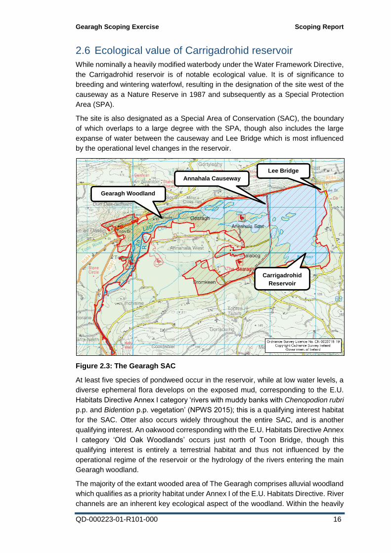
2.6 Ecological value of Carrigadrohid reservoir
While nominally a heavily modified waterbody under the Water Framework Directive,
the Carrigadrohid reservoir is of notable ecological value. It is of significance to
breeding and wintering waterfowl, resulting in the designation of the site west of the
causeway as a Nature Reserve in 1987 and subsequently as a Special Protection
Area (SPA).
The site is also designated as a Special Area of Conservation (SAC), the boundary
of which overlaps to a large degree with the SPA, though also includes the large
expanse of water between the causeway and Lee Bridge which is most influenced
by the operational level changes in the reservoir.
Figure 2.3: The Gearagh SAC
At least five species of pondweed occur in the reservoir, while at low water levels, a
diverse ephemeral flora develops on the exposed mud, corresponding to the E.U.
Habitats Directive Annex I category ‘rivers with muddy banks with Chenopodion rubri
p.p. and Bidention p.p. vegetation’ (NPWS 2015); this is a qualifying interest habitat
for the SAC. Otter also occurs widely throughout the entire SAC, and is another
qualifying interest. An oakwood corresponding with the E.U. Habitats Directive Annex
I category ‘Old Oak Woodlands’ occurs just north of Toon Bridge, though this
qualifying interest is entirely a terrestrial habitat and thus not influenced by the
operational regime of the reservoir or the hydrology of the rivers entering the main
Gearagh woodland.
The majority of the extant wooded area of The Gearagh comprises alluvial woodland
which qualifies as a priority habitat under Annex I of the E.U. Habitats Directive. River
channels are an inherent key ecological aspect of the woodland. Within the heavily
Annahala Causeway
Lee Bridge
Gearagh Woodland
Carrigadrohid
Reservoir
Gearagh Scoping Exercise Scoping Report
QD-000223-01-R101-000 17
forested channels there is little or no aquatic vegetation, but where the canopy is
more open, diverse instream vegetation occurs. These areas correspond with the
E.U. Habitat type ‘floating river vegetation’. The anastomosing feature of the alluvial
woodland is particularly pronounced along the course of the Lee, with the river
breaking up into up 15 channels along some cross sections. The islets which form
the channels are notably well-drained. The NPWS SAC site synopsis notes that “The
Gearagh still represents the only extensive alluvial woodland in Ireland or Britain, or
indeed west of the Rhine in Europe. For this reason it is a unique site…[t]he
international importance of the site is recognised by its designation both as a Ramsar
site and as a Biogenetic Reserve.” Freshwater pearl mussel (an E.U. Habitats
Directive Annex II species, though not a qualifying interest for the site at present) and
several species of freshwater sponge are also known to occur in the anastomosing
channels of the woodland.
The attributes and targets for the Alluvial Woodland component of The Gearagh are
detailed in the Site Specific Conservation Objectives 1 for the SAC. These are
reproduced in Appendix 2.
2.7 Ecology of The Gearagh woodland
With respect to the remaining extant area of The Gearagh woodland, as described
by Brown (1997), the ecosystem consists of a myriad of small islands and islets
dissected by hundreds of channels. Mean island length is only 40 m. The majority of
the islands are wooded with typical floodplain trees such as Alnus glutinosa, Salix
caprea, Quercus spp. and Corylus avellana, but also dry-land trees and shrubs such
as Betula pubescens, Fraxinus excelsior, Crataegus monogyna, Ulex europaeus and
three species of Prunus (avium, spinosa and padus); before 1954 Taxus baccata
was also present.
As noted by Perrin et al. (2008), the current woodland flora is fairly consistent
throughout, with sessile oak (Quercus petraea), Q. robur, ash (Fraxinus excelsior),
hazel (Corylus avellana) and Hawthorn (Crataegus monogyna) the main tree
species. Viburnum opulus is also frequent as seedlings and saplings. Ground flora
species include Hedera helix, Athyrium filix-femina, Euphorbia hyberna, Sanicula
europaea, Primula vulgaris, Filipendula ulmaria, Caltha palustris, Veronica montana
and many bulbs of Allium ursinum visible. Bryophytes are abundant, with Fissidens
spp., Thamnobryum alopecurum, Chiloscyphus pallescens and Conocephalum
conicum the species seen most frequently.
This relatively even mix of species (comprising six to eight tree species) exists even
in islands as small as 2 x 10 m (Brown et al., 1995). The reason for this is the uneven
topography of the islands caused by mounds, pits and flood-channels. The mounds
are mainly the result of windthrow of trees. As the tree leans or falls a mound of soil
is moved as the root mass is lifted. Also, when a tree falls, pits are created. Another
1 https://www.npws.ie/sites/default/files/protected-sites/conservation_objectives/CO000108.pdf
Gearagh Scoping Exercise Scoping Report
QD-000223-01-R101-000 18
process that creates pits is overbank (flood) flow scouring around coppice tree bases
and standard trees; this process also enlarges tree-throw pits and creates saucer-
shaped depressions which have been shown to favour the regeneration of willow
(Brown et al., 1995). The result of these processes is that there is over 1 m relief
above bank height and a variation in soil from gleyed to free- draining.
Windthrow also increases channel-edge length because when trees fall they create
bank embayments which are horseshoe-shaped cuts in the bank. These can also be
formed both by root dislocation (Davis & Gregory, 1994) and by flow-deflection (Keller
& Tally, 1979). The embayments are important dead-water zones where organic
matter and silt accumulate.
The channels also promote biodiversity through the co-existence of dead(still)-water
and live(moving)-water channels. The channels can be divided into three types:
1. Relatively straight, trapezoidal, gravel-bedded, fast flowing, glide-run type
channels;
2. Sinuous, irregular, v-shaped, silty-mixed bed, slower-flowing channels; and
3. Channels on the islands only occupied by water during and after overband
floods (flood-channels).
A significant area of The Gearagh is taken up by junctions between these channel
types with the additional complexity produced by tributary junction bars and scour-
holes. In the trapezoidal channels the gravels are iron and manganese cemented
and up to 20% of area can be covered by freshwater sponges, particularly Ephydatia
fluviatilis, which require high levels of suspended organic matter for feeding and a
stable bed for attachment. The more irregular muddy channels contain more fine and
coarse organic matter and the banks tend to be stepped, promoting a rich riparian
vegetation of herbs, grasses and rushes.
From a review of recent aerial photography, the River Lee is relatively difficult to
discern in the southern portion of the site, as it divides into up to fifteen channels.
The Toon River, by contrast appears to be dominated by a single main channel which
becomes more anastomosed once the influence of the Lee asserts itself.
Debris dams (arising variously from fallen trees, sediment deposition in smaller
channels, or low-hanging vegetation trapping debris) are a common feature of The
Gearagh woodland. A small area in the Lee section of the woodland (with four
channels and one debris dam) was monitored through two floods in 1991 and 1992
(Harwood & Brown, 1993). This study found that during floods, river energy is
effectively dissipated by the shedding of flow out from trapezoidal, gravel-bedded
channels to channels of lower hydraulic efficiency, and by overbank resistance. It is
believed that this is responsible for the persistence of debris dams and the co-
existence of different channel types within the woodland. Many of the dams in the
site were found to be living and growth suggested that some were in excess of 10
years old.
It is worth noting that the wooded part of The Gearagh is predominantly inaccessible
to humans due to the character of the anastomosing channels. Access and site
navigation both by foot and boat is extremely problematic and is likely to be classed
Gearagh Scoping Exercise Scoping Report
QD-000223-01-R101-000 19
as dangerous during periods of elevated water levels, when the river channels
become non-wadeable.
2.8 Influences on The Gearagh woodland post-reservoir development
During the period following construction of the Carrigadrohid dam, there have some
been small-scale landscape changes around the periphery of the reservoir, as well
as other apparent changes along the Toon River and within The Gearagh woodland.
These are outlined in the subsections below.
2.8.1 Woodland re-establishment
Since the establishment of the reservoir, agricultural activity on marginal land within
and immediately adjacent to The Gearagh appears to have declined. Some summer
cattle grazing still occurs in some parts of the woodland, though any impacts of this
are localised (Cudmore, 2012).
A direct comparison of aerial imagery from 1974 and 2012 (see Figures Figure 2.6
and Figure 2.10: 2012 Aerial Imagery) reflects how a significant area of enclosed
fields and islands along the northern edge of The Gearagh woodland (below Raleigh
South) which had historically been kept clear for grazing have become progressively
abandoned and colonised by scrub and early secondary woodland. Similar large
areas of re-establishment can be seen north of Annahala West, as well as south and
west of Toon Bridge. Based on a rough comparison of these aerial images, it is
conceivable that the wooded area of The Gearagh has filled in and expanded by 10-
20% during this 40-year period. Without specific surveys to confirm the species
composition of these expanded areas, it is difficult to conclude what type of
secondary woodland has arisen, but it is expected that it will predominantly comprise
areas of willow, birch and alder.
2.8.2 Hydrological changes upstream
The key aspects of the complaint made to the European Commission in 2013 concern
perceived changes to the hydrology of the Toon River upstream of The Gearagh. In
this communication, the complainant (Mr Kevin Corcoran, West Cork Ecology
Centre) states that:
“…the Toon, has of late undergone serious changes to its hydrology to
facilitate afforestation of its uplands and now it is to face further drainage
to accommodate wind farms. This drastic change to the Toon river
hydrology is being ignored by the planners and as a result The Gearagh
alluvial forest is being affected by it due to an increase in flash floods,
which are causing island and channel destabilisation. It is scientifically
clear that when one cuts into the bogs of the uplands they begin to bleed
to death and as they dry out and disintegrate, the rainwater that falls
Gearagh Scoping Exercise Scoping Report
QD-000223-01-R101-000 20
rapidly drains away, to seriously impact on the lowlands below through
increased flash flooding.”.
Mr Corcoran expands upon the above comment in his submission (January 28th
2016) with reference to the Cleanrath Wind Farm planning application [Planning
Reference: 15/6966] as follows:
“Beginning in the late 1980's many of the natural ecological features that
influence the hydrology of the Toon River have been systematically
removed from the Toon Valley catchment. This has resulted in a
progressive and abnormal increase in flash flooding that is effecting
enormous erosive damage to the anastomosing structure of The
Gearagh. The following outlines the cause of these destructive floods -
• The reclamation of farms in the upper and lower floodplain
plateaus has resulted in the removal of most all hedgerows and
the drainage of the floodplains wet-meadows.
• The dredging of the Toon river channel and its embankment to
contain the flood waters from spreading over the natural flood
plain.
• The continued expansion of coniferous forestry plantations in
the upland heaths about the upper flood plain has also resulted
in extensive drainage of these areas.
Up to 1985 very little physical change had been effected on the natural
features of the three floodplains, whereby their ecological, flood
mitigating features insured destructive floods associated with high
precipitation were much less of an occurrence. This is because the
various features insured that the release of the rain water was spatially
spread out over a longer run-off period. Consequently a more moderate
flood occurred that lasted longer and rarely reached extreme peak flows.
This insured the floods had less destructive erosive power.
By 2015, as the flood attenuating features of the river's natural ecology
were removed, the heavy precipitation that normally took several days
to exit from the land now exits in a matter of hours. Following a severe
storm event the increasing level of drainage works have caused a
corresponding increase in rain-water run-off from the land, so-much-so
that the erosive effect of flash flooding has increased both in frequency
and intensity. Those results closer to 2015 indicate that severe flood
events now occur more often, they arrive earlier and have shorter flows
but with exceedingly higher peak volumes. This has magnified the
erosive power of the floods three fold. In effect they arrive as destructive
flash floods.
The final destination of this abnormal flooding is The Gearagh alluvial
forest. The immediate effects of this scenario, has been a progressive
erosion of The Gearagh's multi-stream complex into a single channel.
Numerous alluvial islands are being washed away while several of the
Gearagh Scoping Exercise Scoping Report
QD-000223-01-R101-000 21
branching channels are either silting up or blocked by debris. This
condition is very visible through Google earth maps as a distinct blue
line, whereby the Toon River increasingly forms a single channel eating
into The Gearagh forest at Toon Bridge.”
Mr Corcoran supplements this argument with an Opinion Statement from Professor
David Harper of the University of Leicester, who conducted research and wrote on
The Gearagh approximately 12-15 years ago. In this communication, Professor
Harper asserts that:
“The past 30 years have seen more insidious, slow changes to the outer
parts of The Gearagh that put at risk its whole structure and unique
value. The greatest is the drainage of the Toon catchment, which results
in greater and more powerful flood events sweeping down the channel,
eroding the formerly-stable islands in the northern part of The Gearagh.
This process must have started with the straightening of the Toon river
to make its floodplain amenable to intensive agriculture (hence
unavailable for temporary flood storage) some decades ago,
accentuated by clearance of rough land for intensive agriculture
(speeding rainfall runoff into drainage channels and the river) and by
floodbanks along the river and tributary channels. The consequence of
these actions together must have removed almost all the natural 'sponge
effect' temporary flood storage from the middle and lower catchment, so
that flood peaks are shorter and stronger. This has visibly eroded away
islands that slowed the flood down as waters entered The Gearagh,
preventing it from being diverted into many channels.
The high risk now is that the Toon river, with too much power, slicing into
The Gearagh - clearly visible on Google Earth as a broad straight blue
line breaking the green canopy - will continue to push in, causing tree
fall and island erosion from the ancient woodland parts. Comparison with
the Lee entering The Gearagh from the south - a much larger river, but
one with natural 'sponge effect' of temporary flood retention in lakes -
illustrates the problem. The Lee immediately anastomoses north of the
road bridge, as the Toon once did west of Toon Bridge.”
The above commentaries highlight the specific issues of downstream impacts of
changes to the upstream hydrology of the Toon River. From a review of available
aerial imagery (1974, 1995, 2000, 2005 and 2012), it is indeed apparent that in recent
decades, some agricultural intensification has taken place along the Toon River
upstream of The Gearagh, with field boundaries being successively denuded in some
areas, particularly on the Coolcaum floodplain immediately upstream of Toon Bridge.
This lower stretch of river has a distinct canalised aspect and from information
gleaned from local landowners during the site visit, is subject to occasional removal
of instream vegetation to reduce flooding of the adjacent fields.
Gearagh Scoping Exercise Scoping Report
QD-000223-01-R101-000 22
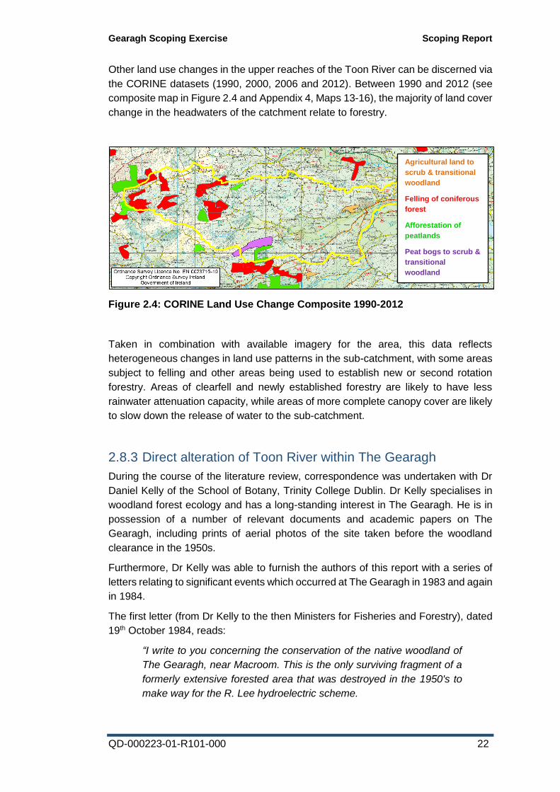
Other land use changes in the upper reaches of the Toon River can be discerned via
the CORINE datasets (1990, 2000, 2006 and 2012). Between 1990 and 2012 (see
composite map in Figure 2.4 and Appendix 4, Maps 13-16), the majority of land cover
change in the headwaters of the catchment relate to forestry.
Figure 2.4: CORINE Land Use Change Composite 1990-2012
Taken in combination with available imagery for the area, this data reflects
heterogeneous changes in land use patterns in the sub-catchment, with some areas
subject to felling and other areas being used to establish new or second rotation
forestry. Areas of clearfell and newly established forestry are likely to have less
rainwater attenuation capacity, while areas of more complete canopy cover are likely
to slow down the release of water to the sub-catchment.
2.8.3 Direct alteration of Toon River within The Gearagh
During the course of the literature review, correspondence was undertaken with Dr
Daniel Kelly of the School of Botany, Trinity College Dublin. Dr Kelly specialises in
woodland forest ecology and has a long-standing interest in The Gearagh. He is in
possession of a number of relevant documents and academic papers on The
Gearagh, including prints of aerial photos of the site taken before the woodland
clearance in the 1950s.
Furthermore, Dr Kelly was able to furnish the authors of this report with a series of
letters relating to significant events which occurred at The Gearagh in 1983 and again
in 1984.
The first letter (from Dr Kelly to the then Ministers for Fisheries and Forestry), dated
19th October 1984, reads:
“I write to you concerning the conservation of the native woodland of
The Gearagh, near Macroom. This is the only surviving fragment of a
formerly extensive forested area that was destroyed in the 1950's to
make way for the R. Lee hydroelectric scheme.
Agricultural land to
scrub & transitional
woodland
Felling of coniferous
forest
Afforestation of
peatlands
Peat bogs to scrub &
transitional
woodland
Gearagh Scoping Exercise Scoping Report
QD-000223-01-R101-000 23
The surviving woodland, in the vicinity of Toon Bridge, is of enormous
scientific importance and educational value. It is unique in Ireland, and
there is nothing like it in Britain either; its nearest parallel is in the
forests of the Rhine, on the border of France and Germany. The
Gearagh has attracted a lot of recent interest: the Young Scientist of
the Year Award was given to Mr. T. Hickey, of Macroom, for his study
of this area…It is therefore extremely dismaying to find that the
surviving woodland has suffered severe damage in 1983 and again in
1984. A broad swathe has been bulldozed right through the wood
below Toon Bridge, not only destroying the vegetation but threatening
to affect the water-table, and hence threatening the very existence of
this unique ecosystem. I ask you, Sir, to do all that is in your power to
prevent further destruction, and to ensure that an effective
conservation policy is instituted for the area.”
A second letter (from Dr Kelly to Mr J. M. McCarthy of Cork County Council Planning
Department), dated 25th February 1985, presents a greater level of detail and
includes a sketch map of the extent of the damage to the site. It reads:
“Thank you for your letter of 5th December 1984. I now enclose , as
you requested, a map showing the location of recent damage to The
Gearagh woodland. Within the zone marked 'Area of woodland
destruction', a swathe has been cut through the woodland through
felling of trees and destruction of islets, by bulldozer or similar
machinery. The length of destruction is at least one mile, starting below
the 300-yard mark downstream (east) from Toon Bridge. This was
carried out during 1983-84. I enclose a photograph taken in 1984 to
give some impression of the seriousness of the damage to this unique
woodland.
Besides the direct destruction and uglification, this damage affects a
wider area; the artificial channels created have lowered the general
water-table. I am informed that in mid-winter 1984-85 many of the
natural stream channels in this area were still dry as a result of the
interference described. Some of this damage to the wider ecosystem
may be virtually irreversible. May I appeal to your Department to
ensure that no further destruction of this kind is permitted.”
Scans of these letters are presented in Appendix 1; unfortunately the photo
mentioned in the above letter could not be sourced before the publication of this
report. The sketch map referenced above (hand-written notes on a six-inch map of
the area, while very rough, and not to scale), shows the area of destruction to follow
the course of the Toon River for at least a half of the distance between Toon Bridge
and what was estimated to be the open water area of the reservoir downstream; see
Figure 2.5.
This significant event has not been previously reported in any scientific literature or
planning correspondence relating to The Gearagh. This is presumably because the
majority of published scientific studies have focused on the anastomosing features
Gearagh Scoping Exercise Scoping Report
QD-000223-01-R101-000 24
of the more southern Lee component of the system, with the Toon component being
relatively under-studied.
A subsequent letter (to Mr James White of the UCD Botany Department, from J.F.
Williams, Secretary of the ESB), dated 18th April 1985, reads:
“Thank you for your letter of the 3rd April, addressed to Mr. O'Leary,
together with a copy of your paper about The Gearagh Woodland, Co.
Cork. Unfortunately, Mr. O' Leary died some months ago.
The damage to the woodland below Toon Bridge in 1983 was caused
by a man using a bulldozer in the mistaken assumption that he owned
the land. The problem was brought up with him and he agreed not to
cause further damage to the area. This man has also died. You may
be assured that the E.S.B. are particularly sensitive about the
preservation of The Gearagh.”
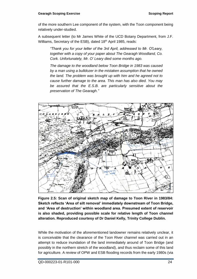
Figure 2.5: Scan of original sketch map of damage to Toon River in 1983/84:
Sketch reflects ‘Area of silt removal’ immediately downstream of Toon Bridge,
and ‘Area of destruction’ within woodland area. Presumed extent of reservoir
is also shaded, providing possible scale for relative length of Toon channel
alteration. Reproduced courtesy of Dr Daniel Kelly, Trinity College Dublin.
While the motivation of the aforementioned landowner remains relatively unclear, it
is conceivable that the clearance of the Toon River channel was carried out in an
attempt to reduce inundation of the land immediately around of Toon Bridge (and
possibly in the northern stretch of the woodland), and thus reclaim some of this land
for agriculture. A review of OPW and ESB flooding records from the early 1980s (via
Gearagh Scoping Exercise Scoping Report
QD-000223-01-R101-000 25
www.floodmaps.ie) does not indicate any significant flood events occurring in the
Toonbridge area in the years immediately preceding these clearance works.
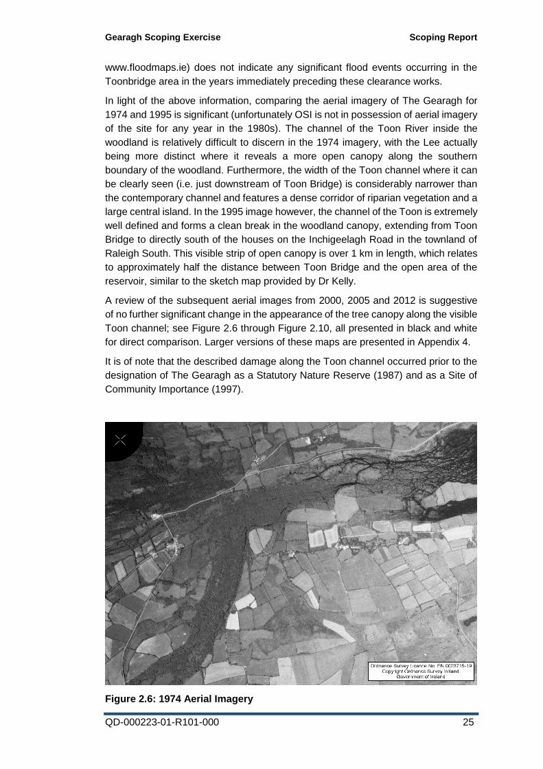
In light of the above information, comparing the aerial imagery of The Gearagh for
1974 and 1995 is significant (unfortunately OSI is not in possession of aerial imagery
of the site for any year in the 1980s). The channel of the Toon River inside the
woodland is relatively difficult to discern in the 1974 imagery, with the Lee actually
being more distinct where it reveals a more open canopy along the southern
boundary of the woodland. Furthermore, the width of the Toon channel where it can
be clearly seen (i.e. just downstream of Toon Bridge) is considerably narrower than
the contemporary channel and features a dense corridor of riparian vegetation and a
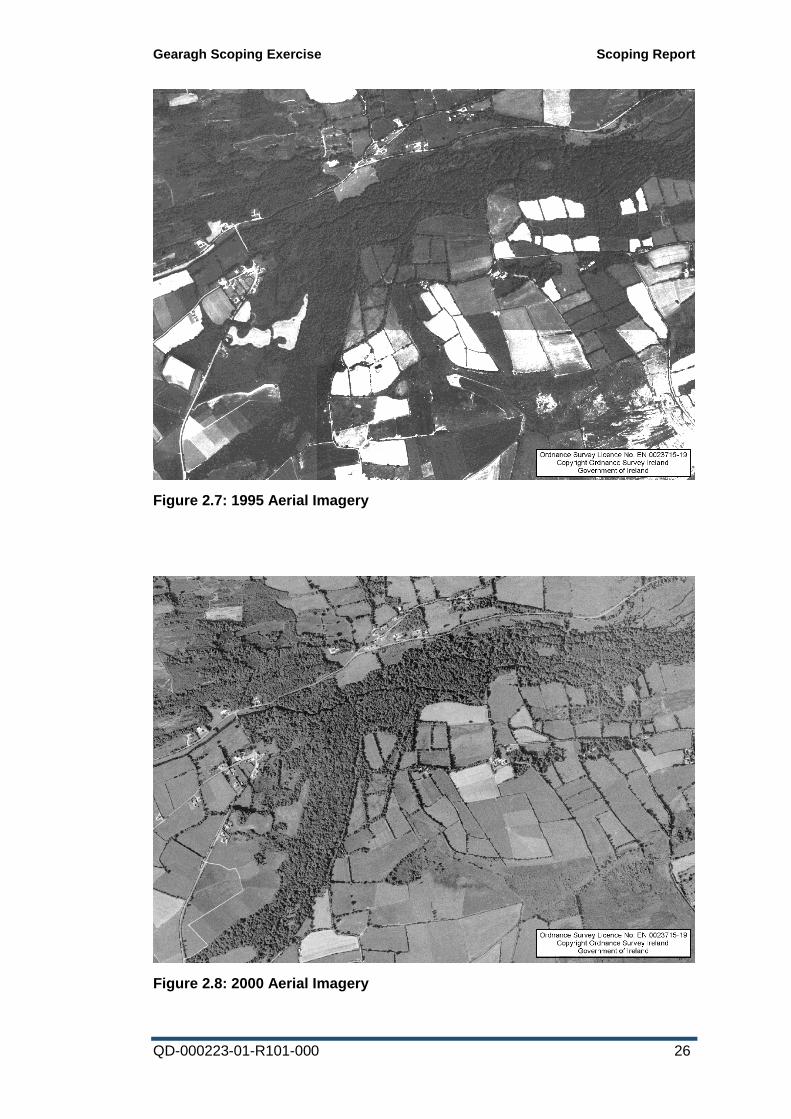
large central island. In the 1995 image however, the channel of the Toon is extremely
well defined and forms a clean break in the woodland canopy, extending from Toon
Bridge to directly south of the houses on the Inchigeelagh Road in the townland of
Raleigh South. This visible strip of open canopy is over 1 km in length, which relates
to approximately half the distance between Toon Bridge and the open area of the
reservoir, similar to the sketch map provided by Dr Kelly.
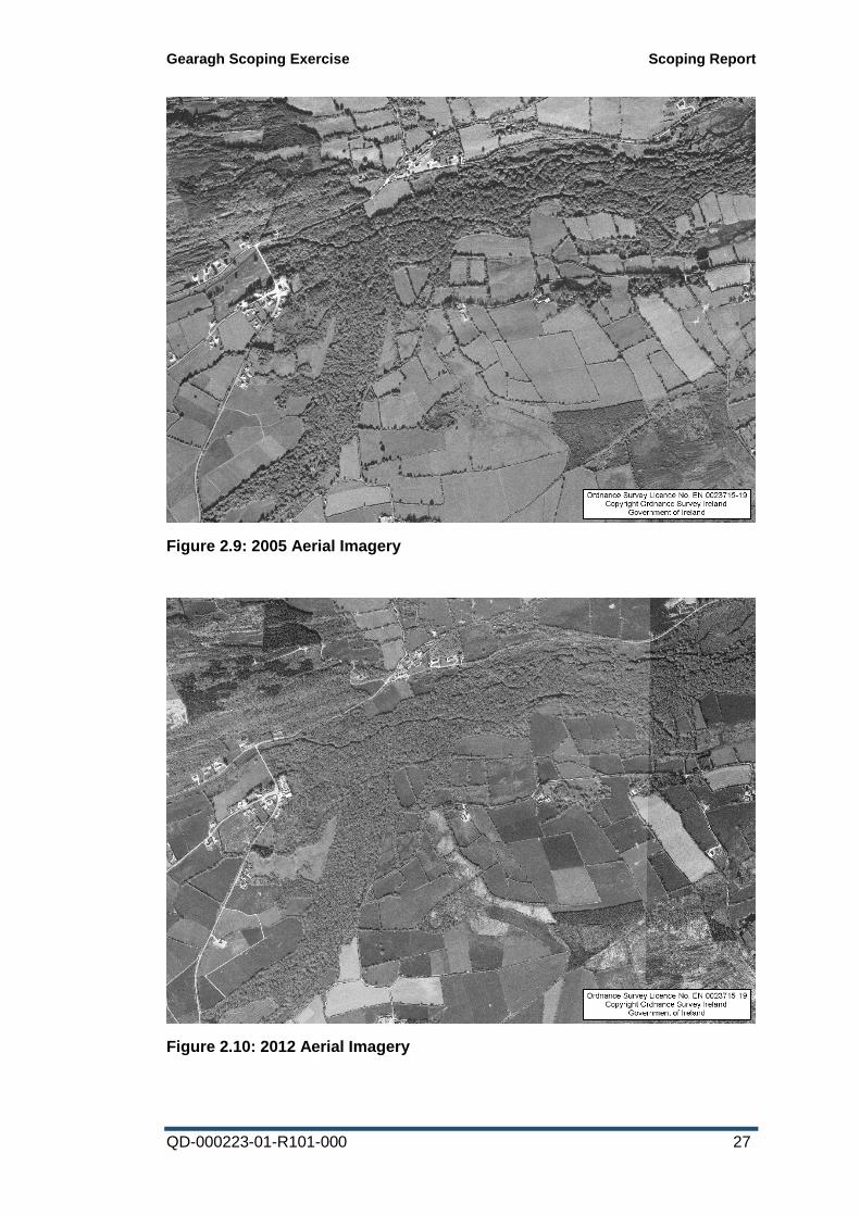
A review of the subsequent aerial images from 2000, 2005 and 2012 is suggestive
of no further significant change in the appearance of the tree canopy along the visible
Toon channel; see Figure 2.6 through Figure 2.10, all presented in black and white
for direct comparison. Larger versions of these maps are presented in Appendix 4.
It is of note that the described damage along the Toon channel occurred prior to the
designation of The Gearagh as a Statutory Nature Reserve (1987) and as a Site of
Community Importance (1997).
Figure 2.6: 1974 Aerial Imagery
Gearagh Scoping Exercise Scoping Report
QD-000223-01-R101-000 26
Figure 2.7: 1995 Aerial Imagery
Figure 2.8: 2000 Aerial Imagery
Gearagh Scoping Exercise Scoping Report
QD-000223-01-R101-000 27
Figure 2.9: 2005 Aerial Imagery
Figure 2.10: 2012 Aerial Imagery
Gearagh Scoping Exercise Scoping Report
QD-000223-01-R101-000 28
In this context, it is arguable that the current functional hydrology of the Toon River
within The Gearagh woodland has been significantly, if not permanently altered by a
direct human intervention which occurred within the woodland over 30 years ago.
While the route of the channel predominantly still corresponds to that seen in the six-
inch maps, it is conceivable that numerous islets along this course were removed,
the channel widened and the overall water table lowered to some degree. It is very
likely that this has had the knock-on effect of the siltation or abandonment of some
of the anastomosing channels to the north of the Toon channel. The anastomosing
features are possibly less impacted to the south of the channel, as these areas are
still strongly influenced by incoming flow from the Lee component of the system.
It is therefore reasonable to review the complainant’s assertion that the contemporary
dominant Toon channel has arisen as a result of increased erosion due to increased
frequency and intensity of flash flooding within the Toon sub-catchment. While this
may have been a rational assumption in the absence of any other evidence, the
details of the alteration of the channel in 1983/84 provides a very strong alternative
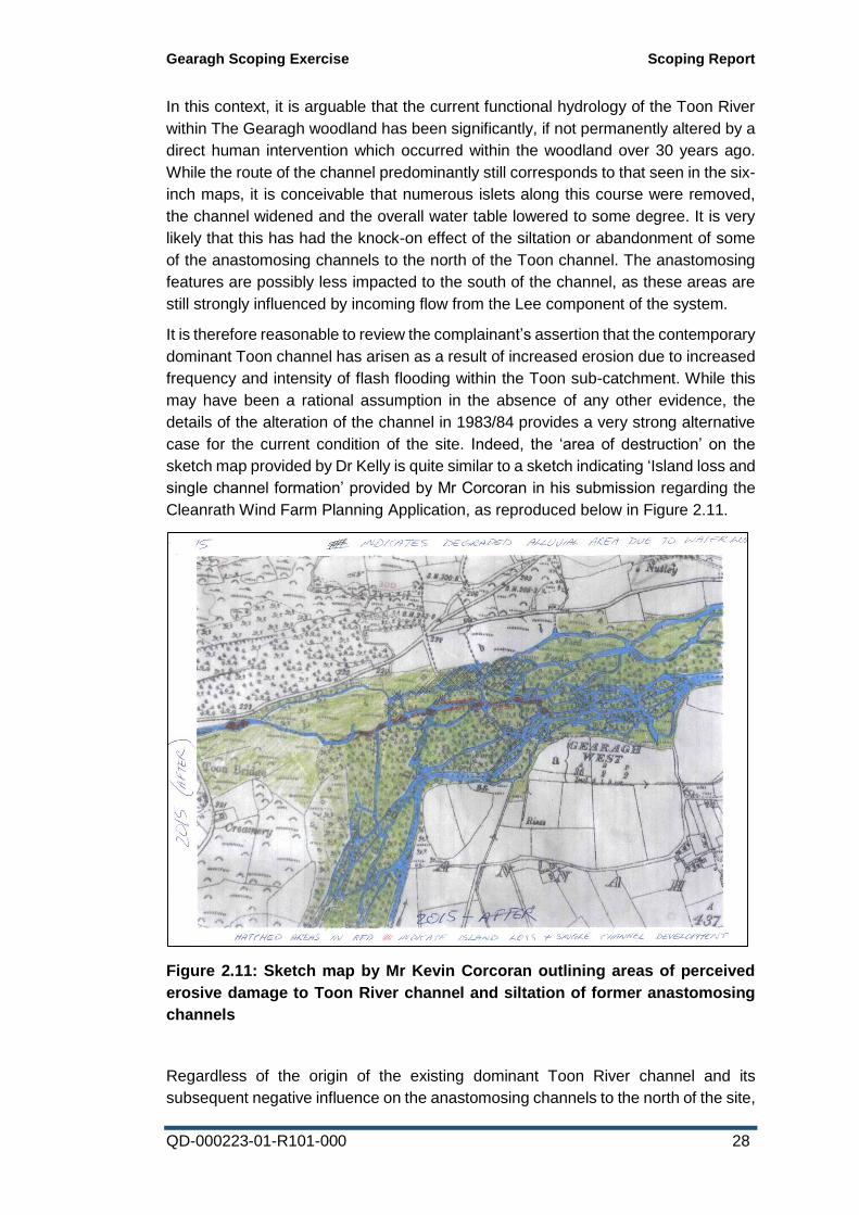
case for the current condition of the site. Indeed, the ‘area of destruction’ on the
sketch map provided by Dr Kelly is quite similar to a sketch indicating ‘Island loss and
single channel formation’ provided by Mr Corcoran in his submission regarding the
Cleanrath Wind Farm Planning Application, as reproduced below in Figure 2.11.
Figure 2.11: Sketch map by Mr Kevin Corcoran outlining areas of perceived
erosive damage to Toon River channel and siltation of former anastomosing
channels
Regardless of the origin of the existing dominant Toon River channel and its
subsequent negative influence on the anastomosing channels to the north of the site,

Gearagh Scoping Exercise Scoping Report
QD-000223-01-R101-000 29
it can still be argued that there is ongoing potential for the artificially altered channel
to be leading to systematic change in The Gearagh woodland. However,
distinguishing new negative erosive features from remnant damage and expected
background levels of channel change from natural tree fall is likely to be a difficult
exercise without the existence of very specific topographic survey data.
Gearagh Scoping Exercise Scoping Report
QD-000223-01-R101-000 30
3 Data Collation and Mapping
3.1 Data sourcing
3.1.1 Available data
The following datasets were collated as part of the scoping exercise:
ESB Property Boundaries
OSI Discovery Mapping
OSI Six-Inch Mapping
OSI Orthophotography 1995
OSI Orthophotography 2000
OSI Orthophotography 2005
DigitalGlobe Aerial Imagery 2012
OSI unrectified aerial imagery 1974
NPWS Designations
NPWS Conservation Objectives
Water Framework Directive sub-catchment boundaries
Corine land use data 1990
Corine land use data 2000
Corine land use data 2006
Corine land use data 2012
Coillte / Department of Agriculture private forestry property boundaries
OSI Discovery river/stream courses
EPA Soils & Subsoils
GSI Geology
OPW & Lee CFRAMS Flood Maps
Lee CFRAMS LiDAR data
Locations of Toon sub-catchment wind farm planning applications
Locations and status of hydrometric gauges
Local Met Éireann rainfall data (Ballyvourney & Macroom-Renaniree stations)
3.1.2 Poor quality or currently unavailable data
While a single EPA hydrometric gauge location exists on the Toon River (Ref:19023,
Coolcaum, installed in 1979), the register of gauges on the EPA website notes that
this location ceased recording in 2001. A request for access to the data for this gauge
was submitted to the EPA as part of the data collection exercise.
EPA was able to supply the available collated flow and level data for this location.
However, this station comprises a staff gauge only, so no continuous records are
available. The data therefore only comprises 72 records over 22 years of
discontinuous spot flow measurements noting river discharge and gauge depth (only
7 data points exist between 1996 and 2001). Due to the very discontinuous nature of
the data (devoid of before-and-after river status etc.) it is of extremely limited value
in relation to the historic hydrological behaviour of the Toon River.
Flood mapping related to the Lee CFRAMS project was collated for The Gearagh
section of the Lee; a series of cross sections were surveyed on the Lee and a number
Gearagh Scoping Exercise Scoping Report
QD-000223-01-R101-000 31
of its tributaries during the compilation of the Lee CFRAMS. Unfortunately, these
cross sections do not incorporate the main channel of the Toon River upstream of
The Gearagh.
In relation to a currently inactive proposal to develop a pumped storage hydroelectric
scheme connected to the Carrigadrohid reservoir, a limited hydrological survey of the
Toon River was undertaken by Malachy Walsh and Partners in 2011 in relation to a
possible bridge crossing of the river. Using the Mean Mid-Point Method for
determination of discharge, along with a flow meter apparatus to measure the velocity
of flow, the discharge in the Toon River on the date of the survey was estimated to
be approximately 0.6m3/s. Two channel cross-sections were surveyed at the river;
however, the Appendix to the draft report for this development which outlines the
location of this survey and the details of the river channel flow modelling undertaken
using the HEC-RAS river analysis system could not be located by staff of Malachy
Walsh and Partners prior to the publication of this report.
3.2 Mapping
Where appropriate, the above datasets were compiled and mapped using ArcGIS
software. These are presented in Appendix 4.
Maps presented are as follows:
1. Toon sub-catchment boundary 2. OSI Historic Six-Inch Mapping 3. ESB Property Boundary 4. SAC NPWS Designation 5. SPA NPWS Designation 6. NPWS Conservation Objectives extent for alluvial woodland 7. Historic origins of woodland within The Gearagh 8. OSI unrectified aerial imagery 1974 9. OSI Orthophotography 1995 10. OSI Orthophotography 2000 11. OSI Orthophotography 2005 12. DigitalGlobe Aerial Imagery 2012 13. Corine land use data 1990 14. Corine land use data 2000 15. Corine land use data 2006 16. Corine land use data 2012 17. Commercial Forestry 18. Soils 19. Subsoils 20. Bedrock/Geology 21. Upstream Windfarm Planning Boundaries 22. Hydrometric Gauge Locations 23. Lee CFRAMS Cross Section Locations 24. LiDAR Digital Terrain Model
Gearagh Scoping Exercise Scoping Report
QD-000223-01-R101-000 32
4 Site Assessment A preliminary site visit to The Gearagh was carried out by ESBI staff ecologist G.
Hamilton on October 11th 2016, with a subsequent visit (accompanied by
geotechnical engineer C. Brangan) on October 21st 2016. Mr Kevin Corcoran was
met during the preliminary visit on the 11th to discuss the site and the objectives of
the scoping exercise, but owing to other commitments, he was unable to personally
accompany ESBI staff to direct them to specific locations of purported erosion or
upstream channel modifications. Observations of the character of the Toon River at
a series of locations upstream of the woodland were made during both site visits.
During the October 21st visit, the main wooded part of the site was accessed from the
Inchigeelagh Road, close to the road junction in Raleigh South. The main channel of
the Toon River was waded for approximately 1 km into the woodland, with a number
of deviations being made to investigate the anastomosing channels branching off
(both flowing and dry). Water levels during both visits were relatively low, following
good periods of dry weather during October, facilitating relatively good access to the
woodland.
General assessments of the alluvial woodland were made, including notes of any
notable erosion and areas of sediment deposition, tree falls and debris dams,
instream vegetation and islet soil composition and condition. A summary of the site
visit observations is presented below.
Of primary note during the survey along the Toon River section of The Gearagh
woodland is the relatively distinct character of the main channel compared to the
anastomosing channels. The main channel is relatively steep-sided and gravel-
bedded with close to vertical banks apparent along a number of stretches (atypical
of the trapezoidal channel cross-section expected in anastomosing systems, see
Section 2.7). Bare earth and exposed roots were sometimes visible on these steep
bank sections. By contrast, the smaller branching channels on either side of the main
channel comprised more sloped bank angles with less exposed root material and
occasional carpets of liverworts, particularly on the less exposed east-facing sides of
the constituent islets. There was a general absence of debris dams across the main
channel, while these tended to be more frequent in the side channels.
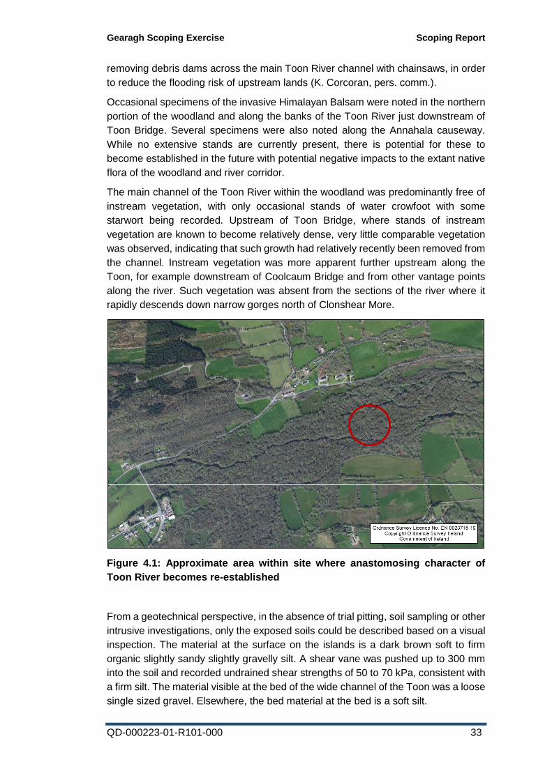
A more intact anastomosing character of the Toon River only becomes apparent
once the influence of the Lee becomes significant; this occurs south of Raleigh South,
and is estimated in the map shown in Figure 4.1.
The more northern channel of the Toon River (shown on the OSI Discovery mapping
as the main route of the river) comprises regular slow moving pools with
comparatively deep silty sediment. Anabranching channels connecting the current
dominant channel with this more northerly channel were often dry and displayed a
build-up of sediment or gravels on the lee side of the islets.
While fallen trees with exposed rootplates were recorded along the main Toon
channel, these were also frequently (if not more so) noted within the woodland to the
north of the river. Apparently some local landowners have been known to engage in
Gearagh Scoping Exercise Scoping Report
QD-000223-01-R101-000 33
removing debris dams across the main Toon River channel with chainsaws, in order
to reduce the flooding risk of upstream lands (K. Corcoran, pers. comm.).
Occasional specimens of the invasive Himalayan Balsam were noted in the northern
portion of the woodland and along the banks of the Toon River just downstream of
Toon Bridge. Several specimens were also noted along the Annahala causeway.
While no extensive stands are currently present, there is potential for these to
become established in the future with potential negative impacts to the extant native
flora of the woodland and river corridor.
The main channel of the Toon River within the woodland was predominantly free of
instream vegetation, with only occasional stands of water crowfoot with some
starwort being recorded. Upstream of Toon Bridge, where stands of instream
vegetation are known to become relatively dense, very little comparable vegetation
was observed, indicating that such growth had relatively recently been removed from
the channel. Instream vegetation was more apparent further upstream along the
Toon, for example downstream of Coolcaum Bridge and from other vantage points
along the river. Such vegetation was absent from the sections of the river where it
rapidly descends down narrow gorges north of Clonshear More.
Figure 4.1: Approximate area within site where anastomosing character of
Toon River becomes re-established
From a geotechnical perspective, in the absence of trial pitting, soil sampling or other
intrusive investigations, only the exposed soils could be described based on a visual
inspection. The material at the surface on the islands is a dark brown soft to firm
organic slightly sandy slightly gravelly silt. A shear vane was pushed up to 300 mm
into the soil and recorded undrained shear strengths of 50 to 70 kPa, consistent with
a firm silt. The material visible at the bed of the wide channel of the Toon was a loose
single sized gravel. Elsewhere, the bed material at the bed is a soft silt.
Gearagh Scoping Exercise Scoping Report
QD-000223-01-R101-000 34
The appearance of the current main channel of the Toon River within the woodland
(i.e. a steep-sided dominant channel with evidence of drying out or silting up of side
channels) is obviously not the natural character for the river in this habitat, as is
evidenced from the more diverse anastomosing features which occur along the Lee
section of the woodland and where the Toon and Lee converge south of Raleigh
South. However, attempting to extrapolate potential contemporary bank and islet
erosion based on the current appearance of the site (in light of the likely extensive
and severe damage that was done in the 1983/84 events) is extremely difficult. By
contrast, it is more clearly apparent that the hydrology in the woodland to the north
of the existing main channel has been negatively altered, with minor channels here
silting up and being progressively abandoned by the river due to a fall in flow volume
and regularity in such channels.
In relation to tree fall within the woodland and its relationship to erosion, it was the
opinion of the geotechnical engineer that erosion is probably more likely to be the
consequence of island breakdown following tree fall, rather than the river
undermining the root system during strong flow events, subsequently leading to
windthrow. Erosion scouring the edge of an islet could undermine the tree somewhat,
but it expected that the root system would be quite extensive and act to stabilise the
island as a whole, through trapping debris and compacting the component alluvial
soil.
By contrast, any tree growing close to a bank will be less stable than a tree in the
middle of an island. It may grow to a size and weight that the root system cannot
support it and it will topple over. This will expose soil that could then be rapidly eroded
away, even in relatively low flows. The tree becoming unstable because it grows too
big seems the more likely cause of most tree falls on the banks of islands. It is worth
noting that there are comparable amounts of fallen trees in the northern portion of
the woodland where there has likely been reduced river power in recent years.
However, it is conceivable that where the canopy has been opened up more along
the extant dominant Toon River channel, that windthrow could be somewhat
increased as the trees here may be somewhat more exposed to the prevailing wind.
Gearagh Scoping Exercise Scoping Report
QD-000223-01-R101-000 35
5 Recommendations
5.1 Basis of recommendations
The scoping exercise has sourced evidence that the primary reason for the current
morphology of the Toon River channel within The Gearagh woodland is likely to be
as a result of a destructive event which occurred over 30 years ago. Attributing
changes in appearance (exclusively or in part) to purported hydrological changes
which may have occurred in the Toon headwaters in the intervening period is
problematic without a reliable and continuous historic flow and depth data for the
Toon River for the intervening period, which unfortunately is not available.
Regardless of the origin of the existing functional hydrology of the Toon River channel
and its subsequent influence on the anastomosing channels to the north of the site,
it can still be argued that there is ongoing potential for the artificially altered channel
to be leading to systematic change in The Gearagh woodland. Such impacts are of
considerable significance to the Conservation Objectives (see Appendix 2) for the
alluvial woodland Qualifying Interest for the site.
However, any hydrological/hydromorphological impacts occurring along the Toon
channel would need to be identified and quantified using a robust empirical
monitoring regime with appropriate levels of control data from elsewhere in the
woodland. It is not advisable to carry out any significant physical measures aimed at
preventing or reducing erosion unless there is reliable quantifiable evidence of such
effects, and clear geographic pinpointing of the location of any impacts; this should
not be based on anecdotal evidence.
It is therefore proposed that a Management Plan be developed for the site,
comprising a suite of measures aimed at facilitating the necessary monitoring.
5.2 Gearagh Woodland Management Plan
Measure 1: Delineate cross-sections within woodland to establish baseline habitat
quality and monitor erosion
To facilitate an empirical assessment of any possible active erosion or deposition
processes occurring within The Gearagh woodland, topographical cross-section
surveys will be carried out at specific locations within the woodland. Ideally these
will encompass both the dominant Toon River channel and some of the smaller
channels parallel to the dominant channel.
Additionally, a number of control cross-sections will be established along the
anastomosed course of the River Lee within The Gearagh woodland; these
controls will be used to establish the natural rate of erosion within the woodland
(the Lee is less dominated by a single channel when compared to the altered
Toon River).
Gearagh Scoping Exercise Scoping Report
QD-000223-01-R101-000 36
As these cross sections will be repeated for the purposes of monitoring potential
changes in the channels, it is essential that repeat surveys are carried out at the
same location with marked endpoints.
In taking measurements across the cross-section all significant breaks of slope
will be marked to provide an accurate representation of any change. Surveys
should be carried out initially on a quarterly basis and possibly directly after high
flow events which could drive geomorphological change within the site.
Given the complex and relatively inaccessible nature of the site, setting up cross
sections to be monitored will not be trivial. The cross-sections will need to sample
a representative length of river within the woodland; it is estimated that up to 5
cross-sections would be sufficient for the Toon section of the site, with a further
2-4 sufficient for the control sections along the Lee channels. Fixed-point
photographs at each location will be taken for subsequent visual comparison of
the monitoring locations; these will be taken from specific reference trees
adjacent to the river channels which will be marked and GPS-located.
Based on consultation with NPWS, the potential for including in-stream
vegetation surveys (i.e. macrophytes, bryophytes, lichens and freshwater
sponges) will also be considered as part of the survey design process, following
further engagement with NPWS. ESB has indicated that it is amenable to funding such surveys, assuming that the associated cost is in line with expectations. There may also be the opportunity to include island vegetation
surveys adjacent to the location of the cross-sections. Such data is valuable as
the flora component of islands has the potential to be correlated to islet erosion
and stability.
Measure 2: Winter canopy drone survey
A drone survey of the woodland along the Toon channel will be carried out during
the winter months, to take advantage of bare canopy and elevated water levels,
so active channels can be distinguished. This will provide a highly detailed
baseline image of the site, against which further channel change or windthrow of
trees close to the channel can be compared.
Measure 3: Establish localised erosion monitoring points
A passive monitoring scheme relating to potential erosion of bank and islet soils
will be established through the use of ‘erosion pins’. With careful placement of
such pins they can provide a good estimate lateral adjustment over time, and are
an extremely economic approach. This is a simple technique that comprises of
driving pins into the face of a river bank. While any material that will not decay is
suitable, a small diameter metal pin is preferable as large pins may themselves
lead to localised scour. The pin should be stable and perpendicular to the bank
face. Pins will be of a sufficient length (minimum 1 m) to negate the risk of them
becoming dislodged from an eroding bank face and washing into the river.
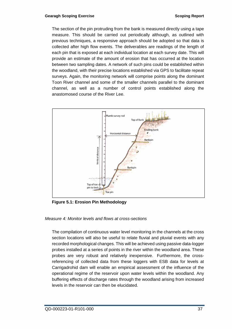
Gearagh Scoping Exercise Scoping Report
QD-000223-01-R101-000 37
The section of the pin protruding from the bank is measured directly using a tape
measure. This should be carried out periodically although, as outlined with
previous techniques, a responsive approach should be adopted so that data is
collected after high flow events. The deliverables are readings of the length of
each pin that is exposed at each individual location at each survey date. This will
provide an estimate of the amount of erosion that has occurred at the location
between two sampling dates. A network of such pins could be established within
the woodland, with their precise locations established via GPS to facilitate repeat
surveys. Again, the monitoring network will comprise points along the dominant
Toon River channel and some of the smaller channels parallel to the dominant
channel, as well as a number of control points established along the
anastomosed course of the River Lee.
Measure 4: Monitor levels and flows at cross-sections
The compilation of continuous water level monitoring in the channels at the cross
section locations will also be useful to relate fluvial and pluvial events with any
recorded morphological changes. This will be achieved using passive data-logger
probes installed at a series of points in the river within the woodland area. These
probes are very robust and relatively inexpensive. Furthermore, the cross-
referencing of collected data from these loggers with ESB data for levels at
Carrigadrohid dam will enable an empirical assessment of the influence of the
operational regime of the reservoir upon water levels within the woodland. Any
buffering effects of discharge rates through the woodland arising from increased
levels in the reservoir can then be elucidated.
Figure 5.1: Erosion Pin Methodology
Gearagh Scoping Exercise Scoping Report
QD-000223-01-R101-000 38
The above measures will be coordinated by the primary landowner of The Gearagh,
namely ESB, who would assume responsibility for the implementation of the initial
monitoring phase (as recommended in Section 5.4) and the subsequent reporting of
findings to a Management Plan Steering Group comprising the key stakeholders for
the site.
In summary, it is envisaged that the above Management Measures will be able to
empirically define the presence or absence of any erosive or other abnormal changes
within the alluvial woodland of The Gearagh. If no such impacts are evident, it can
be concluded that the targets for the Conservation Objectives of the Alluvial
Woodland feature site are being achieved and no further measures will be necessary.
If evidence of erosive impacts is found to be present, then a subsequent Management
Plan will be developed with targeted measures aimed at reducing risk to the integrity
and functioning of the Alluvial Woodland within the SAC.
5.3 Toon Sub-catchment Monitoring Regime
It is also proposed to develop a programme to collect and collate key data relating to
the hydrological behaviour of the Toon River upstream, of The Gearagh. This will
operate in parallel with the Management Plan monitoring within The Gearagh, thus
facilitating the assessment of any causality between the fluvial behaviour of the river
and any recorded habitat change within the woodland.
Based on initial correspondence with the Environmental Protection Agency (EPA)
and the Office of Public Works (OPW), it appears possible that the EPA would be in
a position to carry out the required upstream monitoring activities and subsequently
supply the relevant data to the ESB as part of the Management Plan monitoring
analyses. It is envisaged that the upstream monitoring would comprise the following
actions:
Replacement and re-activation of Toon River Hydrometric gauge
The inactive staff gauge (located just downstream of Coolcaum Bridge, See
Appendix 4, Map 22) should be replaced with an automated flow and depth
monitoring gauge. This will facilitate the development of an accurate record for the
behaviour of the river under different weather conditions, and should allow
comparisons with other rivers in the region during specific time periods.
Comprehensive cross-sectional survey of Toon River
Surveys across width of Toon River upstream of The Gearagh woodland at least
every 1 km. This will allow the development of a hydraulic model for the river and an
assessment of its erosive potential under different flow conditions.
Measurement of channel cross sections is taken across the width of the channel in a
single line perpendicular to the flow. The survey may extend beyond the immediate
channel width to include features such as terraces or embankments. In determining
Gearagh Scoping Exercise Scoping Report
QD-000223-01-R101-000 39
the location of cross sections it is useful to look for (adapted from Harrelson et al
1994):
• A straight section between bends
• Riffles
• Meander bends
• Clear indicators of the active floodplain or bank-full discharge
• Presence of terrace(s)
• Channel form typical of the river
• A reasonable view of geomorphological features
If feasible, these studies should also encompass an assessment of extant sediment
on the substrate of the Toon River immediately upstream of The Gearagh.
5.4 Period of monitoring
It is envisaged that a minimum of 2 full years of monitoring data collection will be
required to fully determine baseline conditions, though it is conceivable that more
time might be necessary should climatic conditions during this 2-year period result in
atypical hydrological conditions within the site, such as exceptional rainfall, storm or
drought events, which might result in the need to re-establish the baseline condition
of the site. The EPA hydrometric gauge re-installed on the Toon River (as outlined in
Section 5.3) should be left in place and kept operational indefinitely.
5.5 Output data usage - Fluvial geomorphological assessment
Only once an appropriate degree of monitoring data has been collated (as outlined
in Section 5.4) can a scientifically robust fluvial geomorphological assessment (as
recommended by Jervis Good, NPWS, see Appendix 5) of the Toon River within and
upstream of the woodland be carried out. This is likely to better inform the current
status and risks to the woodland.
5.6 Conclusion
In summary, it is envisaged that the above measures in Sections 5.2 to 5.4 will be
able to empirically define the presence or absence of any erosive or other abnormal
changes within the alluvial woodland of The Gearagh. If no such impacts are evident,
it can be concluded that the targets for the Conservation Objectives of the Alluvial
Woodland feature site are being achieved and no further measures will be necessary.
If evidence of erosive impacts is found to be present, then a subsequent Management
Plan will be developed with targeted physical restoration measures aimed at reducing
risk to the integrity and functioning of the Alluvial Woodland within the SAC.
Gearagh Scoping Exercise Scoping Report
QD-000223-01-R101-000 40
6 References & Bibliography Anon. (2007) Back on the Map: An Inventory of Ancient and Long-Established
Woodland for Northern Ireland. Preliminary report, The Woodland Trust, UK, pp. 20.
Brown, A. G. (1997) Biogeomorphology and Diversity in Multiple-Channel River
Systems. Global Ecology and Biogeography Letters, Vol. 6, No. 3/4, Floodplain
Forests: Structure, Functioning and Management (May - Jul., 1997), pp. 179-185.
Brown, A.G., Stone, P. and Harwood, K. (1995) The Biogeomorphology of a
Wooded Anastomosing River: The Gearagh on the River Lee in County Cork, Ireland.
Occasional Paper (no. 32) for the Department of Geography, University of Leicester.
Cudmore, A.V. (2012) The impacts of past land-use on the ecology of an ancient
woodland in south-west Ireland. PhD Thesis, University College Cork.
Davis, R.J. & Gregory, K.J. (1994) A new distinct mechanism of river bank erosion
in a forested catchment. J. Hydrol. 157, 1-11.
Dickson, D. (2005) Old World Colony: Cork and South Munster 1630-1830. Cork
University Press, Cork, Ireland, pp. 726.
ESB Power Generation (2010) Review of Biodiversity Issues. Internal Report.
European Commission (2007) Interpretation manual of European Union habitats.
EUR 27, July 2007. European Commission DG Environment, Nature and
Biodiversity.
Flanagan, P.J. and Larkin, P.M. (1992) Water Quality in Ireland 1987 - 1990. Part
2: River Quality Data. Environmental Research Unit, Dublin.
Goldberg, E., Kirby, K., Hall, J. & Latham, J. (2007) The ancient woodland concept
as a practical conservation tool in Great Britain. Journal for Nature Conservation, 15,
109-119.
Harwood, K. & Brown, A.G. (1993) Changing in-channel and overbank flood
velocity distributions and the morphology of a forested multiple channel
(anastomosing) system. Earth Surface Proc. Landforms 18, 741-748.
Hermy, M., Honnay, O., Firbank, L., Grashof-Bokdam, C. & Lawesson, J.E.
(1999) An ecological comparison between ancient and other forest plant species of
Europe, and the implications for forest conservation. Biological Conservation, 91, 9-
22.
Hickey, T. (1982) An Ecological Study to Save The Gearagh. Aer Lingus Young
Scientist Competition 1982. (Unpublished).
Keller, E.A. & Tally, T. (1979) Effects of large organic debris on channel form and
fluvial processes in the Coastal Redwoods Environment. Adjustments of the fluvial
system (ed. by D.D. Rhodes and G.P. Williams), pp. 169-197. Kendall, Hunt, Iowa.
Makaske, B. (2001) Anastomosing rivers: a review of their classification, origin and
sedimentary products. Earth-Science Reviews 53: 149–196.
McGough, H.N. (1984) Field trip to The Gearagh, Macroom, Co. Cork 19-21 August
1983. Bulletin of the Irish Biogeographical Society 7 : 55-57.
Gearagh Scoping Exercise Scoping Report
QD-000223-01-R101-000 41
McMillan, N. (1977) Limosella aquatica L. at The Gearagh, West Cork; an addition
to the County flora. Irish Naturalists' Journal 19: 53.
Mighall, T., Timpany, S., Blackford, J., Innes, J., O’Brien, C., O’Brien, W. &
Harrison, S. (2008) Vegetation change during the Mesolithic and Neolithic on the
Mizen Peninsula, Co. Cork, south-west Ireland. Vegetation History and
Archaeobotany, 17, 617-628.
NPWS (2015) Site Synopsis: The Gearagh SAC [000108]. National Parks and
Wildlife Service, Department of Arts, Heritage, Regional, Rural and Gaeltacht Affairs.
NPWS (2016) Conservation Objectives: The Gearagh SAC 000108. Version 1.
National Parks and Wildlife Service, Department of Arts, Heritage, Regional, Rural
and Gaeltacht Affairs.
NPWS (2016) The Gearagh SAC (site code 108) - Conservation objectives
supporting document - Water courses of plain to montane levels with the Ranunculion
fluitantis and Callitricho-Batrachion vegetation and Rivers with muddy banks with
Chenopodion rubri p.p. and Bidention p.p. vegetation. Version 1. August 2016.
National Parks and Wildlife Service, Department of Arts, Heritage, Regional, Rural
and Gaeltacht Affairs.
Ó Murchadha, D. (1993) Gaelic land tenure in county Cork: Uíbh Laoghaire in the
seventeenth century. In: Cork: History & Society: Interdisciplinary Essays on the
History of an Irish County (eds P. O'Flanagan & C.G. Buttimer), pp. 213-248.
Geography Publications, Dublin, Ireland.
O'Connell, J. (2008) The Gearagh: A Community & Oak Forest Lost Forever; Scéal
Beag, Trua Mór. Googie-Woggie Publishing, Cork, Ireland, pp. 40.
O'Donoghue, S. (1996) The Flooding of the Lee Valley. Tower Books, Ballincollig,
Ireland, pp. 189.
O'Reilly, H. (1955) Survey of The Gearagh, an area of wet woodland on the River
Lee, near Macroom, Co. Cork. Irish Naturalists' Journal 11 : 274-286.
Perrin, P.M.; Daly, O.H. (2010) A provisional inventory of ancient and long-
established woodland in Ireland. Irish Wildlife Manual No. 46. National Parks and
Wildlife Service.
Perrin, P.M.; Martin, J.; Barron, S.; O'Neill, F.H.; McNutt, K.E.; Delaney, A. (2008)
National survey of native woodlands 2003-2008. Unpublished report to National
Parks and Wildlife Service.
Rackham, O. (1980) Ancient Woodland: Its History, Vegetation and Uses in England.
Edward Arnold, London, UK, pp. 624.
Sheppard, R. (1993) Ireland's Wetland Wealth. I.W.C. Dublin.
White, J. (1985) The Gearagh woodland, Co. Cork. Irish Naturalists' Journal 21 :
391-396.
Recommended