i
. .
J
.
iECON[IAISSAMCE SURVEY!
COALi OF THE GETHING FORMATION
PEACE RIVER-PINE RIVER REGION, ,’
M. E. HOPKINS
H i J. GLUSKOTE~ 1.
July-August I.969
GEOLOGICAL BRANCH ‘; ASSESSMENT RF:P6tfi,T. I
._
. . . .
-.,
I
SlJM!WRY-ABSTRACT
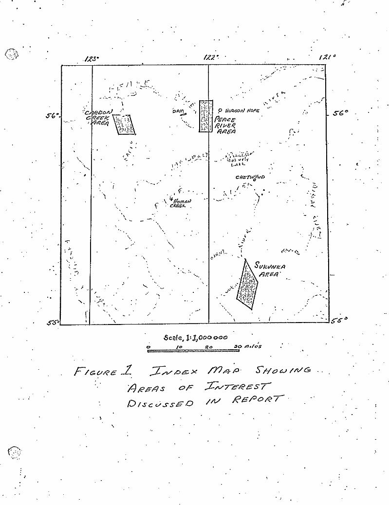
Three areas, which are potentially attractive with regard to
Coal PrOdUCtiOn, were investigated during preliminary field studies
of Cretaceous coals in the Peace River-Pine River region. TIleSi?
.three are, in what we feel is the order of their importance, Carbon
Creek area, Sukunka River area, and Peace River-Portage Mountain area.
1. A number of relatively thick coal seams crop out in the
Carbon Greek basin. Tha thicker coals occur along Eleven Mile ..- I . .
Creek and are found in the more intensely folded central portion of
the Carbon Creek Syncline. North of Eleven Mile.Creek the coal _
bearing strata ulithin the Gothing Formation ark more gently dipping
and are structurally favorable for mining. We did not observe coals
over five feet thick in this area but feel that the portion of the
stratigraphic section which we did not.observe may represent 90 pert-ent
of the rook units present. .
,. If thicker seams are found to be present
with sufficient lateral extent, this more gently folded area would .
then represent a large mineahle reserve* It is necessary to drill
this area to further explore for coal. Three drill'hole sites are
suggested. Drilling equipment could possibly be transported into
the area on barges on the new Peace River Reservoir. 'Otherwise
trsnsportation within this area is-difficult.
2, The coal bearing Gething Formation, lying to the southeast
of the Sukunka River also appears to be in a structurally favorable
region $th respect to coal recovery. A seam in excess of seven.
feet (total thickness B9 inches) has been found as well as several thinner
seams. The area of relatively gently foldad,coal bearing strata
&tends at least three miles further southeast than shown on
(1) . .
. .
(SUNNARY-ABSTRACT continued)
,.
L
2.
8’ ‘. published maps of the region. Further fib work to delineate
the areal extent of the Gething Formation and drilling to
ascertain the extent of the 7 feet 5 inch coal seam are both
strongly recommended.
The area of outcrop:of i$le Gething Formation from this
Sukunka area to Hasler Greek has yet to be geologicalLy mapped
at any scale. Reconnaissance mapping of this area should also
be undertaken. .: L' _:
, 3. SeveraL' small coal mines have operated in the'portage
- Mountain area, site of the nell) W.A.C. Bennett Dam;. Published
geologic maps suggest that the dips in the coal-bearing units
eastward from Portage Mountain'flatten somerrhat and may be at
mineable depths on the broad, fl.at, alluvium covered area betuieen
Portage Mountain and Hudson Hope. Some drilling has been reported
in this area and drilling may also have been done in this region
in conjunction with construction of the dam. Coal prospecting
by drilling in this area cotild possibly prove a de& coal reserve.
.
s _
.-
. . .
I
:,
.
’
S6O
. *
:
.:
.’
. . . .
INTf?O!XJCTION
-
Outcrop areas of the Upper Cretacecus Cething Formation,
as mapped on several of the Geolqgitial Survey of Canada's 4 inches
:' to the mile geologic maps, wore examined in an effort to delineate
those areas &ware a'combination o f thick coal beds and relatively
gentle strusturo tuould warrant subsequent exploration. Outcrops
in this heavily wooded area, a portion of the Inner Foothill 6elt .
.-.: of the Rocky mountains, are scarce and for the most part, confined c ,
to stream cuts. Outcrops of coal seem to be found more easily
. under two conditions: when the ooal is overlain rather closely
by, sandstone, and when the beds are steeply dipping.
Essentially the entire sequence of the Gething appears to
be non-marine,,made up of numerous lenticular units of sandstone
generally less than SO feet thick, inte&alated with siltstone, :
shale, and claystone, along with numerous coal beds.' These coals
: appear to be lenticular and are characterized by several splits
. composed of sandstone, siltstone, shale or claystone. Th~ese-coal
beds can be seen to change in thickness and'in 'amount of impurities
(in the form of splits) laterally along the outcrop whenever a
considerable length of outcrop can be observed. Several chemitial
analyses in published reports indicate the coal to be medium to
LOU Volatile Bituminous rank, and are characterized by a low total.
sulfur content and relatively good swelling (caking) properties
when fresh unoxidized coal samples were tested.
Because of the paucity of outcrops, the lenticular nature of
the coals, the lack of marker beds, and thaintense folding,
(3) , . .
.2 (1NTRODUCTIOli"continued) ,.
.
correlation of coal beds is extremely difficult and will be .
accomplished in most areas only by drilling. Before mining is
contemplated this should be carePully carried out becauso of "
the consi<orable number of coal beds and thaix lenticular nature.
Three areas are.discussed in some detail. Thesa are:
1. Carbon Creek, 2. Sukunka River, and 3. Peace River areas.
.Y .c _-
. :
.
,
(4)
. .
. . . .
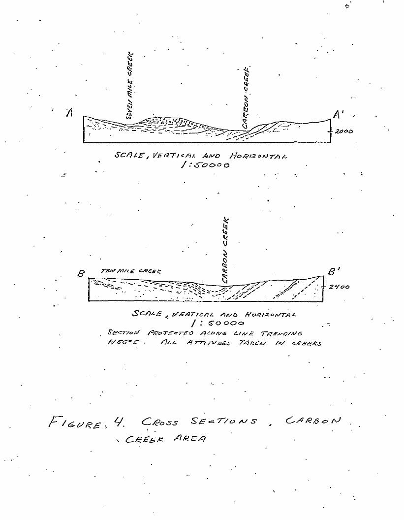
. . I. CRRBON CREEK P.REA
. The arsa~beheen Fir&n Nile and Eleven Mile Creeks
both east and west of Carbon Creek was investigated in detail.
Structurally this area lies in the south-southeast plungingcarbon
Creek Syncline, the axial traca end dip measurements of 6hich are
shown on Figure 3. This syncline is steeper on its east flank
ehere dips generally excssd 20'. On the west side,'howver, in
.= the area of Seven, Nine, and Ten Mile Creeks all dips measured -.
on the wst limb of the structure, with one exception, are less
. than 20' and most are less than i50.
In the southern part of th.e area examined, that is, on the
two forks of Eleven mile Creek, dips are very high near the axis
of the synclina and several rathor intense, minor folds, sometimes
mith vertical beds, are found. Such folds were not seento the
north tghsre the folding apparently is more gentle.
Coal exposures in the Carbon Creek area are confined to the *
stream cuts. According to Mathew (1946) the entire area along
-: and adjacent to Carbon Creek is underlain by the Gething Formation.
Underlying rocks mere observed only in the upper part of the
'tributary draining Carbon Lake in the southeastern part of the area.
Mathews (1946) points out that coals are more numerous in the
upper.part of the Gething, i.e., those rocks il;hich are exposed
near the axial portion of the syncline. Our observations would
seem ta, support this although outcrops of both coal and other
rocks were more numerous in the axial region along Elevsn Mile
Creek than in the remainder of the area. Several coal beds from .
. .
SCALE, VERT/-=RL APO &oAl2OhJrrAL /:~oooo . . . ‘-
.
._
\ ’
. . 2
(CP.REON CREEK AREA continued)
six feet to ten fast thick wsrs seen in this area.
TO the north' along Seven, Nine, and'(ren Mile Creeks, fewer
coal beds mere observed. Mathcws reports several outcrops 3 to 4
feat thick on Seven Mile,Crcek and tz 5 feet 4 inch coal cn.Nine
Mile Creek.
The area u!hich lies betmean Seven Mile Creek and Ten Nils
Creek and extending a short distance north of Seven Mile and
.: .S-,cuth of Ten Nile is structurally less complicated and‘mould
.:
c
appear to be most favorable for mining. It is estimated that
. because uf the nature of the expdsuree we probably 'observed perhaps
10s of the total Gething section which occurs,in this area.' The
total number, thickness, and character of the coal beds certainly
cannot be discerned from this inadequate sample. A minimum of
drilling should enable one to determine whether or not the Gething ,.
formation in this ar&ocntains coal of adkquate thickness to marrant
mining consideration9 . .
It is considered that, because of the extremely tightly folded
nature of the axial area along Eleven Mile Creek, mining would be
too difficult to warrant mere detailed investigation at this time.
Three drill sites show on Figure 5 should provide the maximum
stratigraphic interval in this northern area. These three sites.
would be located on the divides near the axial trace of the syncline,
each hole north of each of the three tributaries to Carbon Creek.
The cpti?um position for thick coal in each of these holes would
be rather deep, somewhere near the maximum r&able depth, which
might be as much as 2,500 feet. The deeper coals would have greater
lateral extent up the limbs of the synclino. Coals occurring at
shallow depths near the axis mould be expected to have minimum lateral
extent. Shallower holes could be drilled in the creeks near.the axis,
. .
(CARI~ON CREEK nim continued) 3
realizing that portions of the section Lying above the drill sit'es -
would not be encountered.
Roughly the area of most favorabLe structural relations is 'I
1-t about 4.5 miles in a northwest-southeast direction and 1.5'miles
I ',in a northeast-southwest direction, totalling 13.5 square miles. .
Not considering the increase in area resulting from dipping beds,
a five foot coal underlying this araa would constitute a resource
of some.77 miLlion tons of coal in the ground. Because of the ,:-'
. nature of tha Gething Formation to contain numerous coal beds,
it is considered Likely that multiple-seam operations might be
carried 'on, at least over part of the area. Complications resulting
from thickening and thinning and the presence of shale, siltstone
and claystone splits in the.coals are also likely to be encountered,
but these should be resolved by additional drilling if results of
. . the initial drilling warrants further study.
.: It should also be pointed out that at the present water level,
. . the Carbon Creek arm of'the Peace River Reservoir extends to
within about one-fourth mile from the mouth of Seven Nile Creek.;
When full (eievstion 2200 feet) the reservoir will extend about
one mile up Carbon Creek above the mouth of Seven Mile Creek. This
will make for somewhat more favorable transportation facilities for .:
this area, alloiuing for the use of barges in bringing in drilling
equipment.
If the initial investigations wrrant, reconaissance study 5
should be started further south in the Carbon Creek and McAllister
Creek areas where several coals were ::reported by Mathews (1946) eho
stated that the Carbori Creek structure plunges to the northwest
and :Soses its identity near the h&ad of McAll,ister Crce!:. However,
. .
(CARBON CREEK AREA continued) ., .- 4 . .
he does state (p.17) that south of Eleven Mile Creek, the
. . structure 1s complicated by several minor folds. . .
._.
.P _-
.
.
. . .,
_.
c
.
.
. .
. .
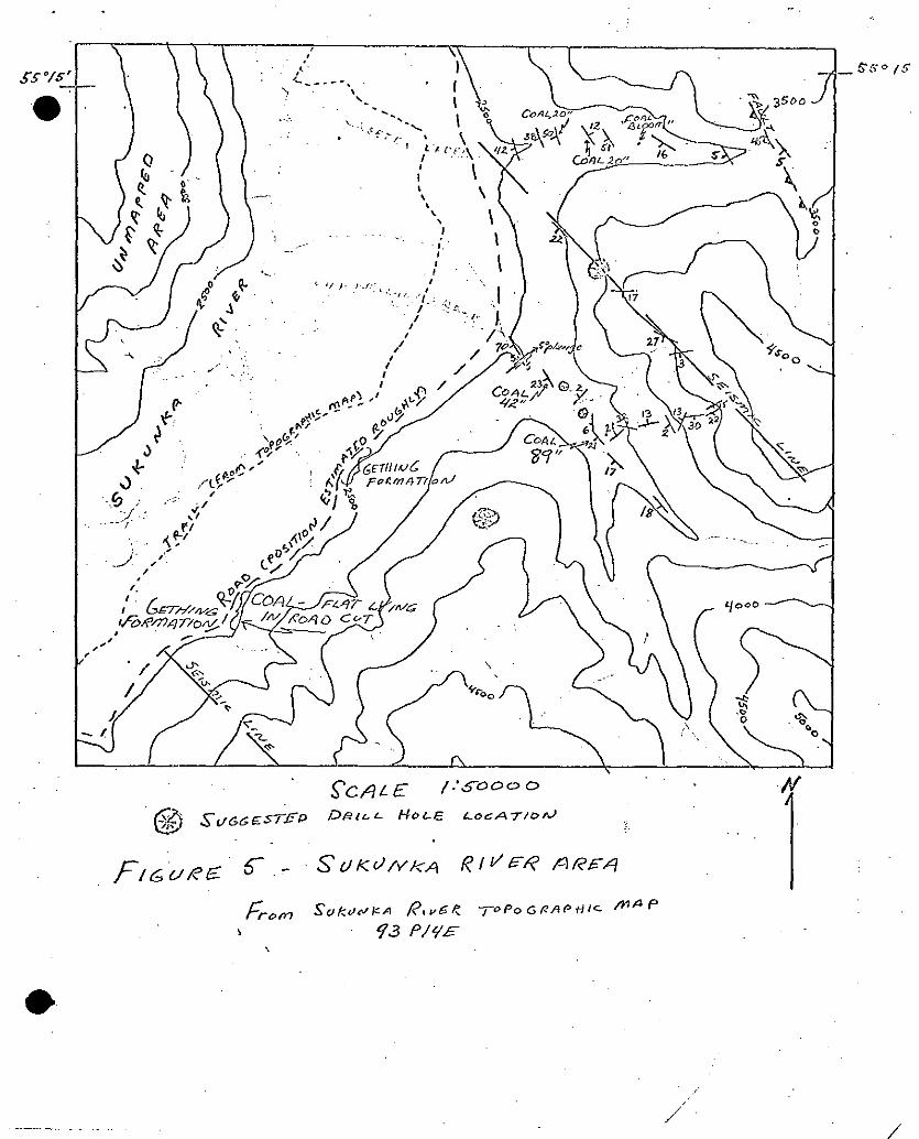
. . II. SUKIJNKA RIVER AREA
A. Geology
Rocks of the Gcthing Formation crop out along the Sukunka
River for several miles upstream of the junction of the Sukunka
with the Burnt River and are also exposed in road-cuts along the
logging road &ich lies on the east side of the Sukunka River. This
.: ' .: area is indicated on Figure 1 and 2 and is also mapped~geblogically
on the Geological Survey of Canada Map 19-1961, Dawson Creek (one
. inch to four miles). As mapped in Map 19-1961, the Cething croIjs
out in a belt that is only four miles wide and strikes northwest-~
SouthcaSt. The area in which the Gething is present on the north
side of the Sukunka River has not bean mapped geologically and is
left blank. '_
Figure 5 includes the southern most portion of the Gething
Formation on the southeast side of the river with altitudes taken
along Skeeter Creek and Chamberlain Creek. The location of several
co&s are ir$cated. A fault of significant porportions v:as observed
in Skceter Creek but relatively gently folded beds were observed in
Chamberlain Creek. The rock: of the younger, gently.dipping,
Moosebar and Commotion Formations can be seen forming sandstone.
cliffs above the Gething Formation. The two coals obssrved in
Chamberlain Creak are 42 and 69 inches in thickness and were relatively
gently dipping where observed.
The southwestern contact of the Gething Formation is shomn
on the GSC msp as a fault, placing the Jurassic end lower Cretaceous
Nikanassin Formation in contact mith the Gcthing. This fault is not
correctly mapped and, at least for three miles further to the .'
sou!thwest than is shov!n on the GSC map, the coals, siltstones, and ISI ..___ ~.._ ~.____ ~.
1’ /
z .
SLJKUNKA RIVER AREA continued) .
*
carbonaceous shales of the Gething Formation can be seen in road
cuts, for the most part rather gently dipping. The rocks capping
the hills above this southwestern extension'of the Gething formation . .
are also flat-lying to gently dipping.
Extending the lower contact of the Cething Formation at
least three miles to tha southnest increases the possibility that .: .̂ a coal seam may be present of sufficient thicknesS and.of
: . sufficient lateral extant to be mined economically.
.
8. Recommendations
1. The areal. extent.of ths Gething Formation southeast
of the Sokunkn should be mapped in detail. The structure of these
strata should also be determined. This is especially important in
thc,czse of that portion of the Cething Formation lying to the
. southwest of the incorrectly mapped fault on CSC Map 19-19611'
Geologic mapping in this area may be greatly assisted by the
air photos. 'The prominent sandstone,cliff-forming units suggest that
this uould be an exceptional area within the Cretaceous in that much
mapping may be possible from the photographs,
Drilling will,.no doubt, be necessary to map the extent of the
thicker (greater than seven feet) coal observed in Chamberlain Creek.
The first drill hoJ.e could be effe0tivel.y placed along the southeast- ,
trending seismic line between Skeeter Creek and Chambsrlain Creek.
.~ ,'> Bulldozer roads to former drill sitos.along thi? line are in fairly
good condition and could be made passable with little effort.
:, (10)
. I a-
.
(SLIKUNKA F&R AREA continued) '3 ,. .
Further drilling would then also be necsasary on the hill lying
to the south of Chamberlain Creel<.
2. The area lying to tha northwest of the Sulcunkn River
and southwest of Hasler Creek has not been mapped.
The Gething Formation undoubtedly underlies much of this
.
.: area; Rdconnaissance mapping and prospecting for coal in'this _: , ares is strongly recommeridad. AEcess to this region is-poor with.
. no roads or trails shown on the topdgraphic maps. The river has
recently been bridged, although.there is no r&d on the west side,
and seistii& lines have been cut through a portion of the area.
.
. .
. .
. .
III. PEACE RIVER AREA
The outcrop area of the Gething Formation north of the
Peace River was briefly examined in the vicinity of a few small
drift mines. The most recent mine, on the Summers Ranch, ceased
opera&ns about 10 years ago. Each of theso mines was hand-operated, .
and capable of only small production. Dips were rather high in
the mines observed..
In the exposures in ths Peace Rive Canyon south and east of _-
the IrJ.A.C. Bennett Dam, several coal beds between 4 and 6 feet thick
can be obsarved (Stott, 1968, measured geologic sectioh). The
six-foot bed was mined in the immediate vicinity of the dam.
To tha east of the anticlinal belt which passes through
Portage Mountain and Bullhead Mountain is a fairly wide area covered
by unconsolidated Guaternary deposits. On the HaLfway River Geologic
Map (No. 22-1963) a rather broad area (Formation 17) is shown
in tha southeastern corner of the map. The Gething in this area is
overlain by the:Buckinghorae 'Formation (equivalent at least in part
to the Moosebar Formation of the Pine River area). The pattern-of
the Buckinghorse outcrop on the geologic map suggests that dips
may be less to the cast of the Bullhead and Portage Mountain
anticlinal areas. The fern dip. measurements shown on this map further
\ I substantiate this structural picture.
The King Gethiny mines (Nos. 1 and 2) operated on the east side
of Portqge mountain in coals 6 to 7 feet thick dipping eastward at
about 25'. Other coals of comparable thickness are reported in the
area. It is thought that wildcat drilling in the topographic flat
to the east of Portage and Bullhead T4ountains.might establish the
thickness, continuity, and structural relations of those deals.
(12)
. .
(PEACE RIVER fiREA.continued)
The first drilling should be
outcrops.
.2
done relativsiy near the known
Drilling operations would be relatively simple,inesmuch
as the a~cn is croeeed by fairly good roads. Relatively thick
unconsolidated deposits might be expected, which would of course
.p hamper the drilling. -_
It is advised that an attempt be made to obtain records
of co,, drilling that was certainly conducted relative to the
W.A.C. Bennet‘t Dam constructioti.
,
(13)
. .
: .
. s ,
:’
‘I BIBLIOGRAPNY
* (Annotated)
The following reports, Papers, etc. a&e concerned with
the stratigraphy and area1 geology of the Cething Formation'in
the Peace River-Pine River area.
Beach, H. Hi, and Spiuek, J., 1944, Dunlevy-Portage mountain
map area: Geol. Surv. Candda, Paper 44-19, 13 P. ._ c
Report of field mapping in Peace River Area.' Geologic map
included extends from east of Portage Mountain to‘approximately
lo-miles west of site of Dam;
Hughes, J. E., 1964, Jurassic and Cretsceous strata of the Bullhead
Succession in the Peace end Pine River Foothills: British Columbia
Dept. Mines and Petroleum Resourcea, Bulletin No. 51,73p.
Stratigraphic study including Gcthing Formation.
Hughes, J.E., 1967, Geology of the Pine Valley: Britidh Columbia
Dept. [rIines and Petroleum Resources. Bulletin No. 52, 137~. '. .
Geologic map of Pine Valley, 1 in&c 1 mile, extending from
$ to 5 miles north and south of Pine River. Includes Noman
Creek and portions of Willow Creek and Hasler Creek.
Mathews, W. H., 1946, Geology and coal resources of the Carbon.Creek-
Mount Bickford Map area: \ -British Columbia Dept. Mines, Bulletin
No. 24, 27~.
RePort of 1944-1945 field investigations. Intensive field study
(without drilling) of Carbon Creek area. Geologic map does
not include altitute of bedding, .
-.
.,.r
m
2
(BIBLIOGRAPHY continued)
. McKechnie, N .D ., 1948, Pine River Coal Field. Peace River District,
British Columbia; Report on work north of Pine River in the
vicinity of Noman Creek, September 13, 194B-December 1, 1948.
Typewritten report. Xerar copy supplied .by Erameda Resources.
Includes Report of Summer Field Mark, I.940 by F.K. North.
.i
McKechnie, N.D., 1955, Coal reserves of the Haslcr Creek-Pine River
areap British Columbia: British Columbia Dept. of Mines, a . .
BulletinVNo. 36.
Detailed mapping and associated drilling, and trenching in
Hasler area', Willow Creek area, and Noman-Fisher Creek area.
. Intensive work on these three coal containing areas.
MCI-earn, F.H., and Irish, E.J.W., 1944, Some coal deposits of the
Peace River Foothills, British Columbia: Geol. Surw. Canada,
Paper 44-15, 15~.
‘,t) Describes Gething Formation in upper Peace River Canyon and
. King &thing and Packmood mines in detail. _ .
Pringle, D.W., 1969, Report on test coal sample from Pine Pass Coal
Company Ltd., Pine Pass., B.C.
Describes collecting of coal sample from adit at.Noman Creek.
Pugh, D.C., 1960, The subsurface Gething and Bluesky Formations of .
Northeastern British Columbia: Geol. Surv. Canada, Paper 60-1, 20~.
May be especially.important as source of drill hole locations
to east of Portage Mountain. 3
Stott, D.F,, 19G0, Cretaceous Rocks between Smoky and Pine Rivers,
Rocky Mountain Foothills, Alberta and British Columbia:
Geological Survey of Canada paper 60-16, 52~.
This is a preliminary report; See later Stott, 196R.
. (BIBLIOGRAPHY continued)
Stott, D.F., 1961; Type sections of some formations of the
Lower Cretaceous Fort St. John Group n-sac Pine River, British
Columbia: Geol. Survey Canada, Paper 61-U.
Describes Loeer Cretaceo& along Hasler Creek.
Stott, D.F., 1962, Stratigraphy of the Lbv~er Cretaceous Fort St.
.P
John Group end Gething and Cadomin Formations, Foothills
,of.Northern Alberta and British Columbia: Geological Survey '. __ a . .
Canada. Paper 62-39.
Describes Gething Formation .and associated -strata from Peace
River south to Alberta. Primarily stratigraphic, no geologic
map. See stott, 19GO.
.I Sto.tt, D. F., 1968, Lower Crstaceous Bullhsad and Fort St. John
Groups, betwan Smoky and Peace Rivers, Central Rocky Mountain
foothills, Alberta and British Columbia, Geological Survey of
Canada. '.
Includes description of .type section of Gething and colored
geologic map (1% 4 miles). -.
'.
The following gsolcgic maps all include at least part of the .
area of interest: 1.
Dawson Creek, map 19-1961, 1 inch = 4 miles
Halfway k. iver,Map 22-1953, 1 inch = 4 miles
Pine Pass, map 11-1961, 1 inch q 4 miles
. .
Recommended