GEOLOGICAL EXPLORATION AS PER
UNFC STAGES AND FIELD GUIDELINES
By
M.S.Jairam Deputy Director General
Geological Survey of India

India Produces as many as 84 minerals
National Mineral Inventory database is maintained by: IBM for 70 non coal solid minerals GSI for coal and lignite Dept. of Petroleum & Natural Gas for oil and gas
Both government and private exploration agencies followed the classification of mineral reserves/resources evolved by GSI in 1981
Prior to 1981 – No Nationally accepted system
National classification system is 2 dimensional system – with no distinction between technical and economic with an emphasis on geological axis
Overview

CLASSIFICATION OF MINERAL RESOURCES
Basis of Classification
1. Geological consideration
Quantum of Exploration
Geologic nature (mode of occurrence, shape, depth etc)
Common to most system of classification
2. Techno economic consideration
Mining Technology
Processing technology
(emphasis varies on different system of classification)

DIAGRAMMATIC REPRESENTATION OF NATIONAL ORE / RESOURCES CLASSIFICATION
MINING PHASE
DETAILED EXPLORATION PHASE RECONNAISSANCE & PROSPECTING PHASE
Identified Resources Undiscovered Resources (Tonnage) ( Based on surmise)
Ore Reserves ( Tonnage and Grade) Developed Ore ( Mining Reserves with Design, Dilution & Extraction Factor)
Undeveloped Ore ( In Situ Reserves)
Demonstrated
Fully Partly Proved Probable Possible Prospective ( In known areas)
Prognostic ( In unknown areas)

COMPARISON OF CONVENTIONAL INTERNATIONAL AND NATIONAL CLASSIFICATION SYSTEM (1981)
U.S.G.S U.S.S.R CLASSIFICATION NATIONAL CLASSIFICATION Category
Purpose Permissible Error
Category
Purpose Permissible Error
Category
Purpose Permissible Error
A Production planning Mine protection
15-20 % Developed Production planning and mining
0-10 %
Measured
0-20 % B Estimating mining investment and planning
20-30 % Proved Investment decision mine planning
10-20 %
Indicated
20-40% C1 Long term development plans for projecting exploration needs.
30-60 % Probable Backup tonnage to proved reserves for investment decision for mine development
20-50 %
Inferred Planning for further exploration
C2 Planning further prospecting
60-90 % Possible First quantitative approximation for planning for national resources survey

STAGE OF ACTIVITIES OBJECTIVE WORK COMPONENT EARLY RECONNAISSANCE (P-I)
Regional evaluation, for identification of a favourable geological environment.
Synthesis of geological aero geophysical & remotely sensed information data, creation of data base for further study.
EXTENDED RECONNAISSANCE (P-II)
Identification of exploration target usually favourable litho pack, tectonic domain or structure.
Intensive reconnaissance including pitting, trenching & scout drilling.
STAGES IN PROSPECTING / EXPLORATION

IST STAGE PRELIMINARY EXPLORATION ( E – I)
Broad determination of strike extension, width of potential mineralized zone, determination of grade of mineralization, defining possible category of resource as well as conditional resource.
Geological, geochemical and geophysical method, pitting, trenching & sinking of wide spaced drill holes.
2ND STAGE PRELIMINARY EXPLORATION (E-II)
Assessment of reserves & average grades of ores up to the probable category provides basis for prefeasibility study.
Systematic drilling, boreholes designed to intersect ore bodies at least in bed level, mineralogical/chemical characteristics of the ore zone studies. The resource estimation may or may not be done on the basis of the economically viable cut off grade.

Universally acceptable and internationally applicable scheme for the classification and reporting of mineral resources / reserves
Generic principle‐based system in which quantities are classified, using numerical coding system, on the basis of the three fundamental criteria:‐
a. Economic and social viability (E),
b. Field project status and feasibility (F) and
c. Geological knowledge (G) Combinations of these criteria create a three‐dimensional system.
United Nations Framework Classification for Mineral Reserves and Resources and Fossil Energy 2009
(UNFC‐2009)

Status of Implementation of UNFC in India Government of India gave approval for adoption of UNFC in 2003
Field guidelines as per UNFC norms formulated by expert group in 2001 ‐ to be followed by all exploration agencies
Changing to UNFC bent with host of complexities
GSI converting all its earlier estimated resources to UNFC numerical codes by following these field guidelines
GSI carrying out present exploration as per UNFC stages following the field guidelines and classifying the estimated resources by assigning appropriate UNFC numerical Codes.
Exploration carried by Private exploration agencies are not in full conformity with UNFC norms
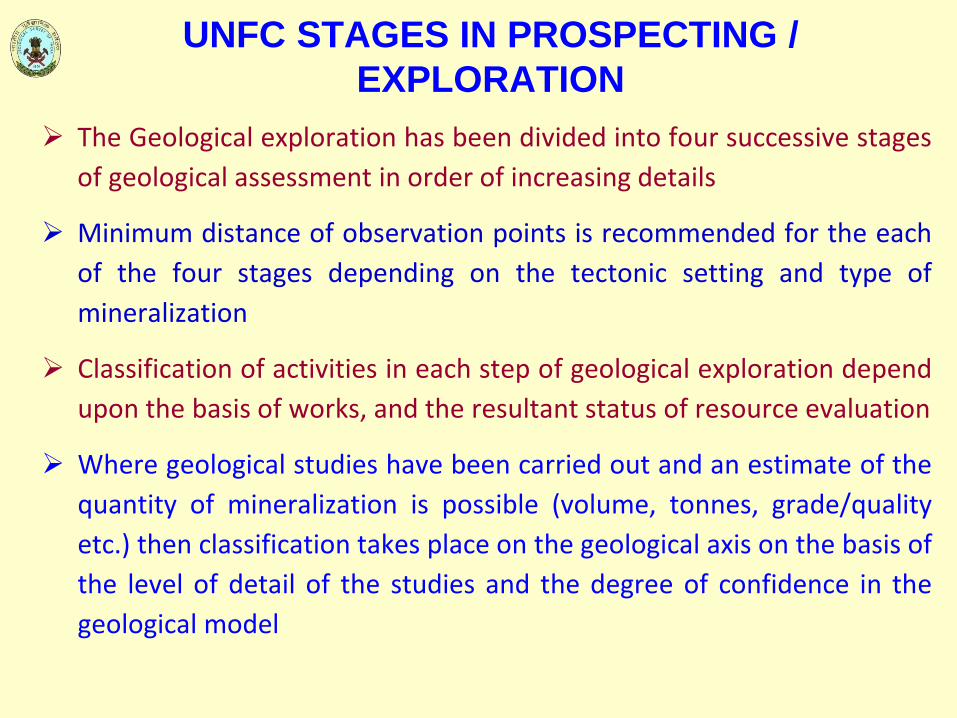
UNFC STAGES IN PROSPECTING / EXPLORATION
The Geological exploration has been divided into four successive stages of geological assessment in order of increasing details
Minimum distance of observation points is recommended for the each of the four stages depending on the tectonic setting and type of mineralization
Classification of activities in each step of geological exploration depend upon the basis of works, and the resultant status of resource evaluation
Where geological studies have been carried out and an estimate of the quantity of mineralization is possible (volume, tonnes, grade/quality etc.) then classification takes place on the geological axis on the basis of the level of detail of the studies and the degree of confidence in the geological model
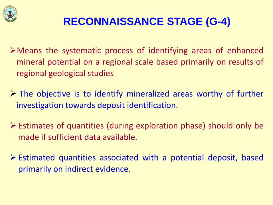
RECONNAISSANCE STAGE (G-4)
Means the systematic process of identifying areas of enhanced mineral potential on a regional scale based primarily on results of regional geological studies
The objective is to identify mineralized areas worthy of further investigation towards deposit identification.
Estimates of quantities (during exploration phase) should only be made if sufficient data available.
Estimated quantities associated with a potential deposit, based primarily on indirect evidence.

EXPANSION OF G4 TO ACCOUNT FOR UNCERTAINTY
In some situations, it may be helpful to express a range of uncertainty
for quantities that are classified on the Geological axis as G4, e.g.
Exploration Projects. In such cases, the following specification shall
apply:
a) G4.2: incremental amount to G4.1 such that G4.1+G4.2 equates to a
best estimate of the quantities;
b) G4.1: low estimate of the quantities;
c) G4.3: incremental amount to G4.1+G4.2 such that G4.1+G4.2+G4.3
equates to a high estimate of the quantities.
Category G4, when used alone, shall reflect the best estimate
and is equal to G4.1+G4.2

PROSPECTING STAGE (G-3)
Prospecting is the systematic process of searching for a mineral deposit by narrowing down areas of promising enhanced mineral potential
The objective is to identify a deposit which will be the target for further exploration
Quantities estimated for the deposits are with a low level of confidence
Estimates of quantities are inferred, based on interpretation of geological, geophysical and geochemical results

GENERAL EXPLORATION STAGE (G-2)
General Exploration involves the initial delineation of an identified deposit
The objective is to establish the main geological features of a deposit, giving a reasonable indication of continuity and providing an initial estimate of size, shape, structure and grade
The degree of accuracy should be sufficient for deciding whether a Pre‐feasibility study and Detailed Exploration are warranted
Quantities estimated for the deposits are with a moderate (medium) level of confidence
Estimates of quantities are indicated, based on interpretation of geological, geophysical and geochemical results

DETAILED EXPLORATION STAGE (G-1)
Detailed Exploration involves the detailed three‐dimensional delineation of a known deposit
Size, shape, structure, grade, and other characteristics of the deposit are established with a high degree of accuracy
A decision whether to conduct a Feasibility Study can be made from the information provided by Detailed Exploration
Quantities estimated for the deposits are with a high level of confidence
Estimates of quantities are measured, based on interpretation of geological, geophysical and geochemical results

Four stages of Geological Assessment Provide Four Resource Categories reflecting increasing degree of geological knowledge and confidence which are:
Reconnaissance (G‐4 Stage) Reconnaissance Resource
Prospecting (G‐3 Stage) Inferred Resource (333)
General Exploration (G‐2 Stage) Indicated Resource (332)
Detailed Exploration (G‐1 Stage) Measured Resource (331)
After Field project status and feasibility (F), Economic and social viability (E) studies Mineral Reserves are classified as:
Proved Mineral Reserves: code 111 Probable Mineral Reserves: codes 121 + 122 Feasibility Mineral Resources: code 211 Pre‐Feasibility Mineral Resources: codes 221+222

TERMS AND CODES IN UNFC 1997
17 Indian Bureau of Mines
ECONOMIC AXIS FEASIBILITY AXIS GEOLOGICAL AXIS CODE
Economic Feasibility Study & Mining Report Detailed Exploration 111
Economic Pre-feasibility Study Detailed Exploration 121
Economic Pre-feasibility Study General Exploration 122
Potentially Economic Feasibility Study & Mining Report Detailed Exploration 211
Potentially Economic Pre-feasibility Study Detailed Exploration 221
Potentially Economic Pre-feasibility Study General Exploration 222
Intrinsically Economic Geological Study Detailed Exploration 331
Intrinsically Economic Geological Study General Exploration 332
Intrinsically Economic Geological Study Prospecting 333
Undetermined Economic Geological Study Reconnaissance 334

Aligning Indian National Classification system to UNFC 2009
National Classification system yet to be aligned with UNFC – 1997 and UNFC 2009
Application of UNFC 2009 to classify quantities based on aligned system can be performed either by:
a) first generating estimates using the aligned system and then assigning those estimates to the appropriate UNFC 2009 class or sub‐class
b) By generating the estimates directly in UNFC 2009 by applying the relevant specifications from the aligned system
Preparation of Bridging Document essential for proper alignment of National System to UNFC 2009
Mapping of National System to CRIRSCO Template and UNFC‐2009 Classes and Categories yet to be carried out
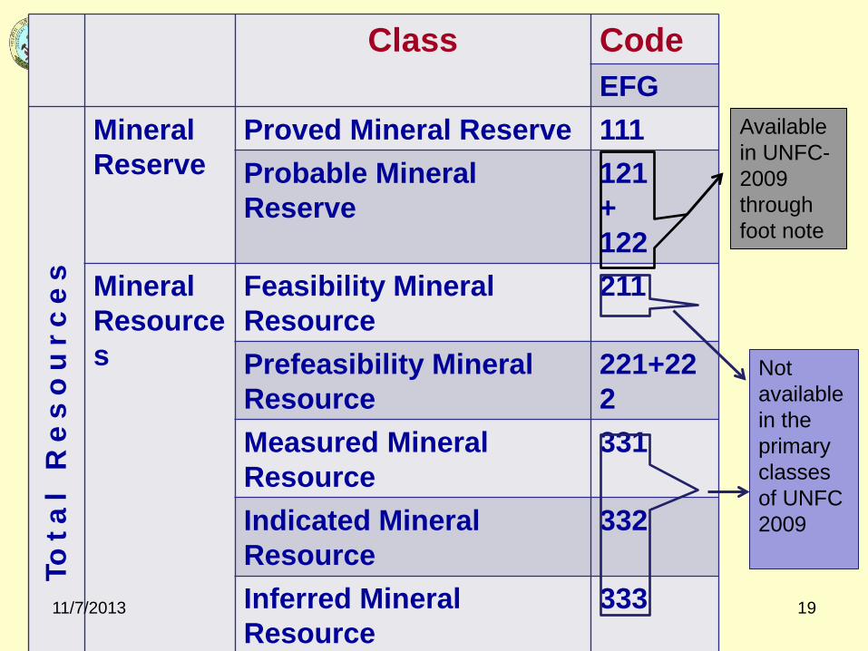
Class Code EFG
Tota
l R
es
ou
rce
s
Mineral Reserve
Proved Mineral Reserve 111 Probable Mineral Reserve
121 + 122
Mineral Resources
Feasibility Mineral Resource
211
Prefeasibility Mineral Resource
221+222
Measured Mineral Resource
331
Indicated Mineral Resource
332
Inferred Mineral Resource
333
11/7/2013 19
Not available in the primary classes of UNFC 2009
Available in UNFC-2009 through foot note

Indicated
Exploration Results
Inferred
Measured
Probable
Proved
(CRIRSCO Template)

Mapping between CRIRSCO‐UNFC1997 & UNFC2009
CRIRSCO TEMPLATE UNFC 1997
UNFC 2009 “Minimum” Categories’
UNFC 2009 CLASS
Mineral Reserve
Proved 111 E1 F1 G1 Commercial Projects
Probable 121,122 G2
Mineral Resource
Measured 331 E2 F2 G1 Potentially Commercial Projects Indicated 332 G2
Inferred 333 G3
Exploration Results 334 E3 F3 G4 Exploration Projects
21
Feasibility(211) & Prefeasibility (221+222) Mineral Resources class of UNFC 1997 is not mapable with CRIRSCO Template
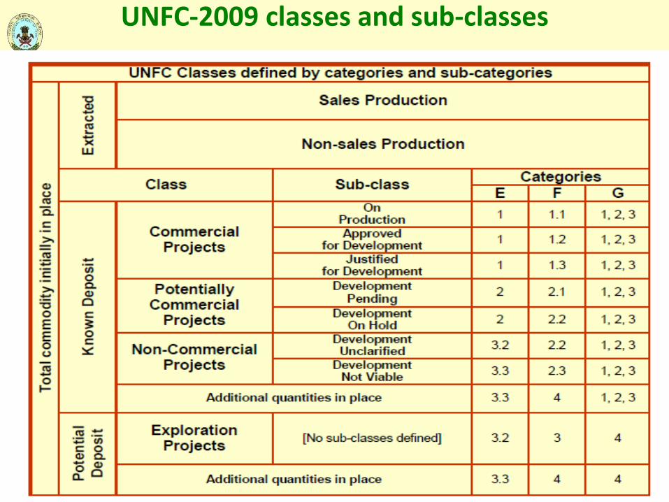
UNFC-2009 classes and sub-classes

Geological Exploration and Field Guidelines
To minimizing scope of variation in interpretation of the broad guidelines of UNFC and resource estimation data, different sets of practical field guidelines in quantitative terms have been standardized for different types of mineral deposits
Depending on the type of mineral deposit, the quantum / level of work / analysis / study under these parameters the category of resource estimate may vary
Field guidelines formulated for all three axes of UNFC namely Geological, Feasibility and Economic axes

Following points were taken into consideration while formulating the field guidelines:
Draft UNFC guidelines of November 1999
Existing exploration practices in India
Indian conditions of mining where small scale mining ia largely practiced
The nature of National Mineral Inventory database
Field guidelines prepared for seven types of deposits

DEPOSIT CLASSIFIED FOR PROVIDING FIELD GUIDELINES
• Stratiform, Stratabound and Tabular deposits of regular habit
• Stratiform, Stratabound and Tabular deposits of irregular habit
• Lenticular bodies of all dimensions, including bodies occurring en echelon , silicified linear zones of composite veins
• Lenses veins and pockets, stock-works, irregular shaped, modest to small sized bodies
• Gemstones and rare metal pegmatite's, reefs and veins
• Placers and residual refractory mineral deposit of hill and valley wash
• Dimension stones

STRATIFORM, STRATABOUND AND TABULAR DEPOSITS OF REGULAR HABIT
Characteristics of deposits
Of regular habit with predictable change in trend with sharp to moderate physical contrast with bounded surfaces, low to moderately steep dipping, simply folded and faulted. Also as blanket capping and surficial tabular bodies
Principal kinds of minerals
Coal seams, lignite beds, iron ore formation and capping, manganese horizons in sedimentary and meta-sedimentary sequences, thick bauxite capping, regional chromite lodes in large ultramafics; limestone, dolomite, barytes, gypsum, evaporites (including potash and salt beds), chalk and fireclay, fuller's earth

G4 (RECONNAISSANCE)
Aerial Reconnaissance: Remote sensing, airborne geophysical etc
1. Geological survey: Mapping on 1:50,000 or smaller scale
2. Geochemical Survey: i) Grab, chip sampling (Nil for coal/lignite) ii) Recording of broad geomorphology, drainage etc
3. Geophysical Survey: Ground Geophysical survey
4. Technological: i) Pitting/Trenching: one or two to expose mineralized zone at ideal location ii) Scout drilling: A few boreholes to know the existence of mineral iii) Sampling: Regional and random chip samples
5. Petrographic and mineralogical studies: To determine principal rock types, mineral assemblage, identification of mineral of interest
6. Synthesis of all available data / concepts
7. The activity as above or less than that required for G3

G3 PROSPECTING 1. Geological Surveys: i) Mapping on 1:50,000 to 1:25000 (for coal/lignite 1:10000)
ii) Linking of prepared maps with topo‐grid iii) Assessment of lithology, structure, surface mineralization, analysis of old workings etc
2. Geochemical Survey: Geochemical sampling rock type wise, soil survey
3. Geophysical Survey: Detailed ground geophysical work, borehole logging
4. Technological: i) Pitting/trenching to explore mineralized zone ii) Drilling borehole spacing: (a) coal, gypsum, potash, salt beds 1000 to 2000m (b) limestone/dolomite 400 to 500m (c) Iron and manganese 200 to 400m (d Bauxite 300 to 400m (e) chromite 300m (f) barite 500m
5. Sampling: Litho geochemical from a well known section, pit/trench and core sampling
6. Petrographic and mineralogical studies: Study of host rock of the deposits and alteration zone, determination of phase in which minerals occur and mineralogical studies (ore microscopic, XRD, EPMA etc), identification of oxidized and primary zones

G2 (GENERAL EXPLORATION)
1. Geological Survey: Mapping on 1:25000 to 1:5000 or larger scale with triangulation points, linking of prepared maps with topogrid and assessment of lithology, structure, mineralization.
2. Geochemical Survey: i) Detailed litho geochemical survey, channel sampling from fresh mineralized rocks exposed by trenching/pitting, ii) recording of deleterious elements and by product elements, iii) for coal/lignite geochemical sampling of coal/lignite and water to be done
3. Geophysical survey: i) Borehole geophysical survey ii) special survey for problem solving
4. Technological : i) Systematic pitting / trenching ii) Drilling Borehole spacing a. coal/gypsum/rock salt 400 to 1000m b. iron and manganese 100 to 200m c. limestone/dolomite/barite 200 to 400m d. bauxite / chromite 100 to 300m. Iii) Sampling: Systematic pit/trench and core sampling iv) Bulk sampling, if necessary v) collection of geoenvironmental parameters
5. Petrographic

G1 (DETAILED EXPLORATION) 1. Geological Survey: i) Mapping – for coal 1:5000 and for others
1:1000 ii) Preparation of detailed topographic cum geological map incorporating lithology, structure, mineralized zone, pits/trench and boreholes etc. iii) Topogrid / triangulation station , identified fiducially linking in the map
2. Geochemical survey: Detailed grid pattern sampling and analysis
3. Geophysical Survey: Detailed and specific borehole geophysical survey
4. Technological: i) Pitting 2 to 5 per sq km ii) Trenching at 200 to 300m spacing iii) Drilling closer spaced a. coal 12 to 15 borehole per sq km b. for open cast project grid spacing may be 100x50m iv) Exploratory mining v) Sampling of pit/trench/core
5. Petrographic and mineralogical studies
6. Geostatistical studies

Deposit Type G-4 Reconnai -ssance)
G-3 Prospe- cting
G-2 General Exploration
G-1 Detailed Exploration
I. Stratiform, Stratabound and Tabular of regular habit a) Pitting/Trenching b) Drilling 1. Salt, Potash etc 2. Iron, Manganese 3. Limestone 4. Bauxite 5. Chromite 6. Baryte
Wide spaced ~5 Boreholes/ 100 sq km
50‐100m spaced Wide spaced 1000‐2000 200 – 400m 400 – 500 m 300 – 400 m 200 – 300m 400 – 500m
25‐50m spaced Grid Reduction 400‐1000m 100 – 200m 200 – 400m 100 – 300m 100 ‐ 300m 200 – 400m
25‐50m spaced Closed spaced Exploratory Mining involved
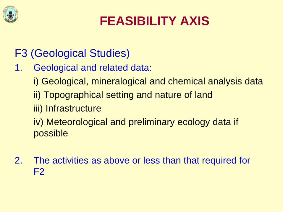
FEASIBILITY AXIS
F3 (Geological Studies) 1. Geological and related data: i) Geological, mineralogical and chemical analysis data ii) Topographical setting and nature of land iii) Infrastructure iv) Meteorological and preliminary ecology data if
possible 2. The activities as above or less than that required for
F2

F2 (PRE-FEASIBILITY STUDY)
1. Geology: local geology, mineralogy, identification of ore types and geometry
2. Mining: Method, Pre‐production plan, development plan, manpower
3. Environment: Baseline data on environment
4. Processing: Proven laboratory scale/pilot scale beneficiation, investigation data, likely establishment
5. Infrastructure and Service, construction activities, brief details
6. Costing: Capital and operating cost – rough estimates based on comparable mining operations
7. Marketing: Demand supply relation, pricing etc
8. Economic viability: Preliminary study of cash flow forecasts
9. Other factors: Statuary provisions related to labour, land, mining, taxation etc.
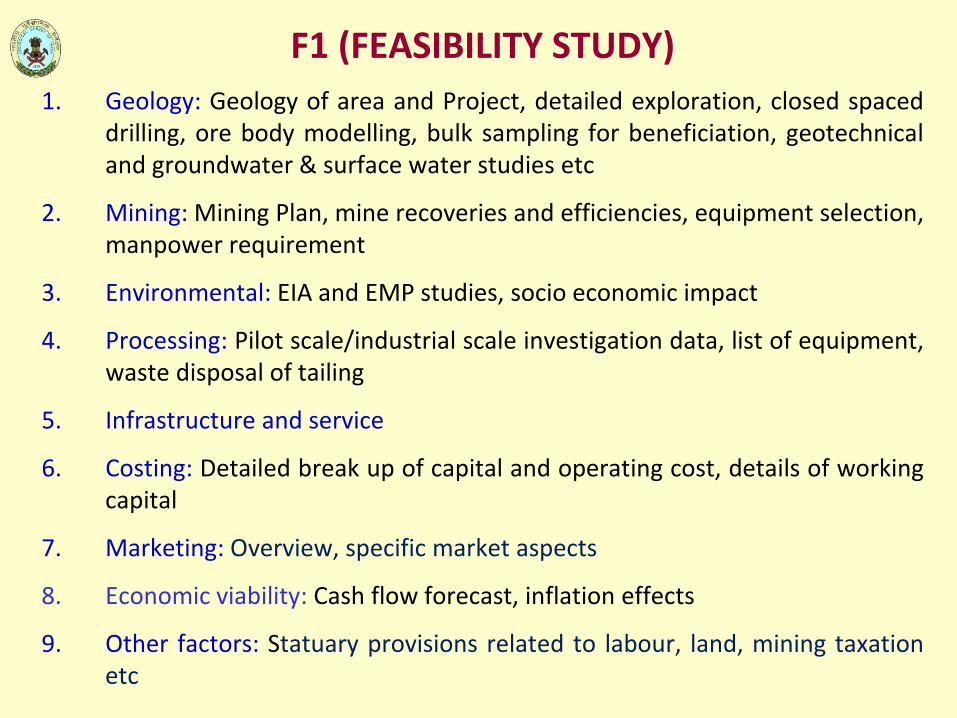
F1 (FEASIBILITY STUDY) 1. Geology: Geology of area and Project, detailed exploration, closed spaced
drilling, ore body modelling, bulk sampling for beneficiation, geotechnical and groundwater & surface water studies etc
2. Mining: Mining Plan, mine recoveries and efficiencies, equipment selection, manpower requirement
3. Environmental: EIA and EMP studies, socio economic impact
4. Processing: Pilot scale/industrial scale investigation data, list of equipment, waste disposal of tailing
5. Infrastructure and service
6. Costing: Detailed break up of capital and operating cost, details of working capital
7. Marketing: Overview, specific market aspects
8. Economic viability: Cash flow forecast, inflation effects
9. Other factors: Statuary provisions related to labour, land, mining taxation etc
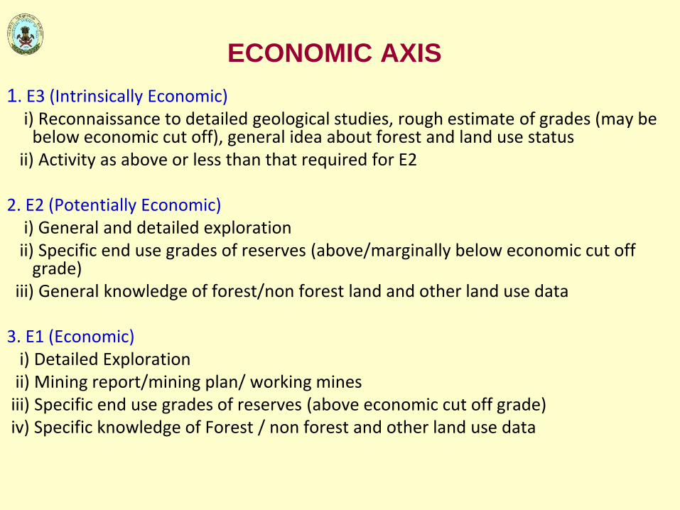
ECONOMIC AXIS 1. E3 (Intrinsically Economic) i) Reconnaissance to detailed geological studies, rough estimate of grades (may be
below economic cut off), general idea about forest and land use status ii) Activity as above or less than that required for E2 2. E2 (Potentially Economic) i) General and detailed exploration ii) Specific end use grades of reserves (above/marginally below economic cut off
grade) iii) General knowledge of forest/non forest land and other land use data 3. E1 (Economic) i) Detailed Exploration ii) Mining report/mining plan/ working mines iii) Specific end use grades of reserves (above economic cut off grade) iv) Specific knowledge of Forest / non forest and other land use data

I LENTICULAR BODIES OF ALL DIMENSIONS INCLUDING BODIES OCCURRING EN ECHELON, SILICIFIED LINEAR ZONES OF COMPOSITE VEIN
Characteristics of Deposit Gradual and abrupt change in thickness and grade along strike and dip
direction; bounding surfaces of mineralized bodies often, but in sulphides mostly, defined by assay contact
a) Massive bodies with irregular shape and grade – homogeneous to inhomogeneous distribution of metal values as in replacement and disseminated type bodies – shape interpretative
b) Steeply dipping narrow bodies with or without pitch, pinch and swell type, with or without bifurcations, partings etc
Principal kinds of mineral Base metal, supergene iron and manganese ore bodies in lateretoid
country, pockety bauxite and nickel-cobalt lateretoid, auriferous quartz reef, PGM in association with sulphides, graphite lenses, porphyry deposit of copper, molybdenum, and tin, pyrite, pyrrhotite bodies

Deposit Type G-4 Reconnai -ssance)
G-3 Prospe- cting
G-2 General Exploration
G-1 Detailed Exploration
II. Lenticular bodies of all dimensions e.g. basemetal, gold, PGE etc a) Pitting/Trenching b) Drilling
Wide spaced Few scout boreholes
Systematic spaced Mostly 100‐200m. Spacing depends on structural complexities. Few boreholes to intersect ore body at two levels
25‐50m for subsurface correlation Close spaced 50‐100m
25‐50m spaced Closed spaced Exploratory Mining involved
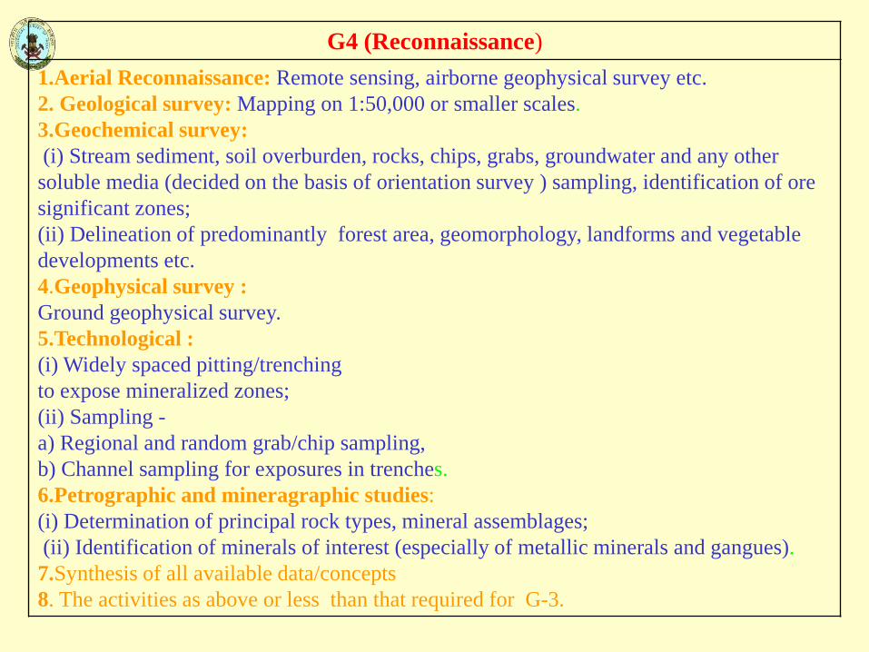
G4 (Reconnaissance) 1.Aerial Reconnaissance: Remote sensing, airborne geophysical survey etc. 2. Geological survey: Mapping on 1:50,000 or smaller scales. 3.Geochemical survey: (i) Stream sediment, soil overburden, rocks, chips, grabs, groundwater and any other soluble media (decided on the basis of orientation survey ) sampling, identification of ore significant zones; (ii) Delineation of predominantly forest area, geomorphology, landforms and vegetable developments etc. 4.Geophysical survey : Ground geophysical survey. 5.Technological : (i) Widely spaced pitting/trenching to expose mineralized zones; (ii) Sampling - a) Regional and random grab/chip sampling, b) Channel sampling for exposures in trenches. 6.Petrographic and mineragraphic studies: (i) Determination of principal rock types, mineral assemblages; (ii) Identification of minerals of interest (especially of metallic minerals and gangues). 7.Synthesis of all available data/concepts 8. The activities as above or less than that required for G-3.

G3 (PROSPECTING)
1.Geological survey:
(i) Mapping on 1:50,000 to 1:5000 scale depending on geology of area; (ii) Linking of maps so prepared with topogrid (iii) Assessment of lithology, structure, surface mineralization and analysis of old history of mining
2. Geochemical survey:
(i) Study of detailed and primary and secondary geochemical parameters close grid sampling) of prospects and their processing rock type-wise and rock type-cum-overburden wise for identification of ore significant anomaly zones
(ii) Recording of deleterious elements, likely by-product elements
3.Geophysical survey: (i) Detailed ground geophysical work (ii) Bore-hole geophysical survey

4.Technological: (i) Pitting/trenching to explore mineralized zones to decipher surface manifestation of mineralization - moderately spaced preferably at 500 - 400m interval; (ii) Preliminary drilling - (a) Spacing will be guided by the structural complexity or nature of discontinuity, (b) Spacing of probe points along strike generally between 100and 200m; (iii) Further drilling to be planned to intersect ore-shoot, ore body at least at two levels with only few deeper level intersections; (iv) Exploration planning to be guided by the result of ground geochemical and geophysical studies, pit sampling/ trench/core sampling (5% check sampling). 5.Petrographic/mineragraphic studies: (i) Petrographic study of rocks of the deposit and its surroundings, alterations (if any), connected with mineralization; (ii) Determination of phase in which mineral of interest occurs; (iii) Mineralogical studies including paragenesis, identification of zones of oxidation and primary zones, grain size distribution, overall characteristics of useful minerals.

G2 (GENERAL EXPLORATION) 1.Geological survey: (i) Mapping on 1:5,000 to 1:1,000 or larger scale with triangulation stations, benchmarks, if any; (ii) Linking of maps so prepared with topogrid, (iii) Assessment of lithology, structure, surface mineralization, analysis of old history of mining. 2. Geochemical survey: (i) Detailed litho-geo-chemical channel sampling from fresh rock exposures, trenches, pits for further refinement of data; (ii) Recording of deleterious elements and likely by-product elements. 3.Geophysical survey: (i) Borehole geophysical survey ; (ii) Special geophysical traverses for problem solving if required. 4. Technological (i) Pitting/trenching for helping surface and subsurface, correlation of mineralized zones; (ii) Drilling- close –spaced drilling to decipher the ore -shoot behaviour at least up to two levels; in general, spacing of probe points along strike may be 100m but in specific cases, depending on the necessity, it may be brought down to 50 m. especially for precious metals; a few probe points for deeper intersections; (iii) Detailed core sampling, bulk sampling for testing of processing technology; (iv) Collection of a biotic geo-environmental parameters. (10% check sampling). 5. Petrographic; Detailed study of data on the Petrographic character of rocks including study of grain size ,texture, liberation characteristics.

G1 (DETAILED EXPLORATION)
1. Geological survey: (i)Mapping‐1:1000 or larger scale; (ii) Preparation of detailed topographical ‐cum‐geological map including all surface geological features, extent of deposit, structure, location of pits/trenches/boreholes, assay plan and sections of exploratory mine development and borehole data. 2. Geochemical survey: (i) Detailed litho‐geo‐chemical channel sampling from fresh rock exposures/ trenches, pits; (ii) Analysis of geo‐chemical data for potential utilization. 3. Geophysical survey: (i) Borehole geophysical survey ; (ii) Special geophysical traverses for problem solving , if required. 4. Technological: (i) Pitting/trenching for helping surface and subsurface correlation of mineralized zones; (ii) Drilling: closer–spaced than that for G‐2 and up to the depth of 100‐50 m. below the oxidation zone ‐ depending on the necessity it may be brought down to 50 m. or less especially for precious metals; a few probe points for deeper intersections; (iii) Sampling‐ detailed core sampling, bulk sampling for testing of processing technology on laboratory/pilot plant scale; (iv) Collection of a biotic geo‐environmental parameters. 5. Petrographic: 6.Geostatistical analysis oDetailed study of data on the Petrographic character of rocks including study of grain size ,texture, liberation characteristics and further refining of data. borehole data (thickness of ore :waste encountered in holes, assay values) if considered necessary.

FEASIBILITY AXIS
F3 (Geological Studies) 1. Geological and related data: Geology of the area, reconnaissance and prospecting by geochemical
and geophysical surveys, general exploration, core & sledge samples for beneficiation, geological maps depicting extent and dimensions of mineralization, lithology of host rock, control and guides of mineralization, infrastructure, environmental baseline data
2. The activities as above or less than that required for F2
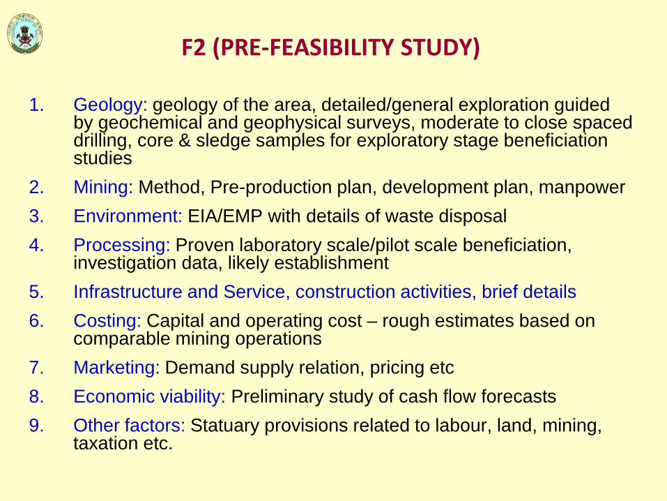
F2 (PRE-FEASIBILITY STUDY)
1. Geology: geology of the area, detailed/general exploration guided by geochemical and geophysical surveys, moderate to close spaced drilling, core & sledge samples for exploratory stage beneficiation studies
2. Mining: Method, Pre-production plan, development plan, manpower 3. Environment: EIA/EMP with details of waste disposal 4. Processing: Proven laboratory scale/pilot scale beneficiation,
investigation data, likely establishment 5. Infrastructure and Service, construction activities, brief details 6. Costing: Capital and operating cost – rough estimates based on
comparable mining operations 7. Marketing: Demand supply relation, pricing etc 8. Economic viability: Preliminary study of cash flow forecasts 9. Other factors: Statuary provisions related to labour, land, mining,
taxation etc.

F1 (FEASIBILITY STUDY)
1. Geology: Geology of area and Project, detailed exploration, closed spaced drilling, exploratory mining upto 2nd level, ore body modeling bulk sampling for beneficiation, geotechnical and groundwater & surface water studies etc
2. Mining: Mining Plan, mine recoveries and efficiencies, equipment selection, manpower requirement
3. Environmental: EIA and EMP studies, socio economic impact
4. Processing: Pilot scale/industrial scale investigation data, list of equipment, waste disposal of tailing
5. Infrastructure and service
6. Costing: Detailed break up of capital and operating cost, details of working capital
7. Marketing: Overview, specific market aspects
8. Economic viability: Cash flow forecast, inflation effects
9. Other factors: Statuary provisions related to labour, land, mining taxation etc

ECONOMIC AXIS
1. E3 (Intrinsically Economic) i) Reconnaissance to detailed geological studies, rough estimate of grades (may
be below economic cut off), general idea about forest and land use status ii) activity as above or less than that required for E2 2. E2 (Potentially Economic) i) General and detailed exploration ii) Specific end use grades of reserves (above/marginally below economic cut off
grade) iii) General knowledge of forest/non forest land and other land use data 3. E1 (Economic) i) Detailed Exploration ii) Mining report/mining plan/ working mines iii) Specific end use grades of reserves (above economic cut off grade) iv) Specific knowledge of Forest / non forest and other land use data

Recommended