www.utiledesign.com | Town of Hull, MA | 12.08.14 1
Hull, MA
Nantasket Beach
Revitalization Plan Draft Redevelopment Scenario
www.utiledesign.com | Town of Hull, MA | 12.08.14 2
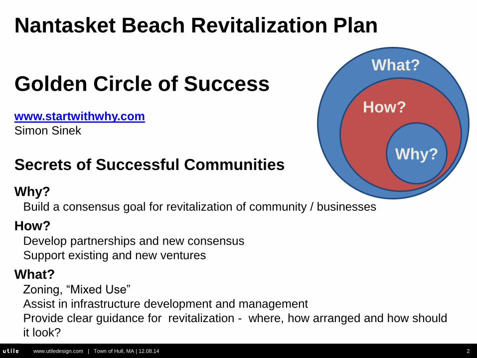
Golden Circle of Success
How?
Why?
What?
www.startwithwhy.com
Simon Sinek
Secrets of Successful Communities
Why? Build a consensus goal for revitalization of community / businesses
How? Develop partnerships and new consensus
Support existing and new ventures
What? Zoning, “Mixed Use”
Assist in infrastructure development and management
Provide clear guidance for revitalization - where, how arranged and how should
it look?
Nantasket Beach Revitalization Plan

www.utiledesign.com | Town of Hull, MA | 12.08.14 3
Consensus Goal from 2011
Community Workshops
“To maximize the town’s commercial tax
base by supporting an environmentally
and commercially sustainable
development model which serves as a
catalyst for a successful economy and
recognizes that Hull’s historic character
and natural beauty and resources are
fundamental (to success).”
Economic Revitalization
Help meet Community needs - better
balance tax burden; meet $60 M in capital
needs.
“Best place to start revitalization”
2004 – Town Plan
Nantasket Beach
Why Revitalize the Nantasket Beach Area?
What do we believe?
What is our goal?

www.utiledesign.com | Town of Hull, MA | 12.08.14 4
Developing Partnerships and New Consensus
Community Participates / Town /HRA / MassDevelopment / Hull
Chamber / South Shore Chamber / Metropolitan Area Planning
Council / MassWorks / DCR / Representatives
Supporting Existing and New Ventures
Rebuilding infrastructure, providing clear direction and new tools
for re-development
Nantasket Beach
How Are We Revitalizing Nantasket Beach?

www.utiledesign.com | Town of Hull, MA | 12.08.14 5
What Has, Is and will Be Done To Create the Framework for Revitalization?
Framework for Nantasket Revitalization 2011 – Goal
DCR Re-Use Committee conducts Community Workshops and defines revitalization goal and planning area.
2012-2013 – Zoning After 23 public meetings the community creates the Nantasket Beach Overlay Zoning District, “Healthy by Design”.
2012 – 2016 - Infrastructure HRA provides engineering/admin funds for $1.95 M MassWorks Grant to rebuild Nan Avenue at “Surfside”.
2014-2015 - Study of two-way street system To relieve congestion at bottlenecks while supporting economic development, Town / HRA / DCR committed funds.
2013-2015 - Provide clear guidance for revitalization Town / HRA / MassDev hire Utile, & Nelson/Nygaard to work with the community on a Pre-development Plan to include site master plan and transportation plan, including parking.
2014 – CTPS pedestrian / bicycle access study, “Livable Communities”
www.utiledesign.com | Town of Hull, MA | 12.08.14 6
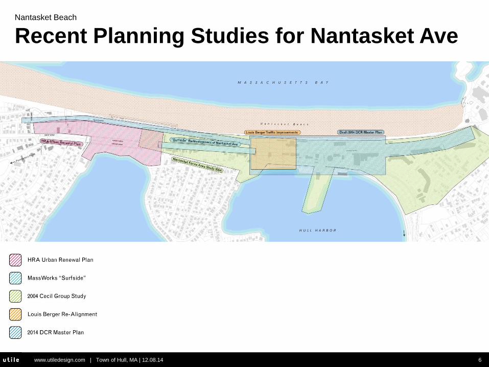
Nantasket Beach
Recent Planning Studies for Nantasket Ave

www.utiledesign.com | Town of Hull, MA | 12.08.14 7
Nantasket Beach
Unified Master Plan
• The Town of Hull and the DCR have collaborated on studying an
integrated street network.
• At sites of study area overlap (Hull Shore Drive and Anastos Corner)
the street sections and road alignment are support the coordination,
and advance the recommendation, of a two-way parallel road
framework.
• Conceptual analysis supports taking the next step in analyzing the
viability of the 2-way system, an engineering level study

www.utiledesign.com | Town of Hull, MA | 12.08.14 8
PROPOSED
450
700
450 700
600
700
700 525
700
450
700
450
100 100 50 50
50 50 50 50
50 50
EXISTING (Wharf to Water)
900
500
400 400
100 700
700
700
1400
700
CS: 0.90
CS: 0.41
CS: 0.41
Nantasket Beach
Roadways Reconfigurations

www.utiledesign.com | Town of Hull, MA | 12.08.14 9
v
900
1,400
850
Mountfo
rd R
950 730
100
140
100 200
1,300
1,180
120
215
80
715
750
700
700
450
450
600
600
450
450
300
200
600
700
300
800
CS: 0.56
CS: 0.57
CS: 0.60
CS: 0.37
PROPOSED
EXISTING (Water to Phipps)
Nantasket Beach
Roadways Reconfigurations

www.utiledesign.com | Town of Hull, MA | 12.08.14 10
1
1. Economic Development
2. Pedestrian Enhancement
3. Public Safety
4. Convenient Access
Greater access and visibility
5. Traffic Reduction
Reduce unnecessary vehicular
circulation
Equal vehicular capacity to one-
way network
Speed can be slower, but just as
many cars get through
Why 2-Way Conversion?
Two-Way Street Grid
One-Way Street Grid
1
1
1
1
1 1 1
1
1 1
1
1
1
1
1 1
1 1
2
2
2
2
2
2
2
2
2
2
1 1
www.utiledesign.com | Town of Hull, MA | 12.08.14 11
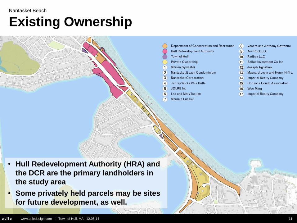
Nantasket Beach
Existing Ownership
• Hull Redevelopment Authority (HRA) and
the DCR are the primary landholders in
the study area
• Some privately held parcels may be sites
for future development, as well.

www.utiledesign.com | Town of Hull, MA | 12.08.14 12
Existing Conditions

www.utiledesign.com | Town of Hull, MA | 12.08.14 13
Design Principles
• Create a beautifully-scaled waterfront town center for Hull residents
• Create a unique and compelling ocean-facing retail and restaurant district
that is a top destination in New England
• Create walkable blocks and streets that are patterned after the blocks to the
north of the development site
• Create a development strategy that is a model for storm “resiliency” in the
face of rising sea levels
• Create a mix of units that take advantage of water views and the walkable
lifestyle offered by the retail boardwalk and beach
• Create a plan that can be phased over time
• Create open space is a natural and cultural resource and contributes to the
resiliency of the town center
www.utiledesign.com | Town of Hull, MA | 12.08.14 14
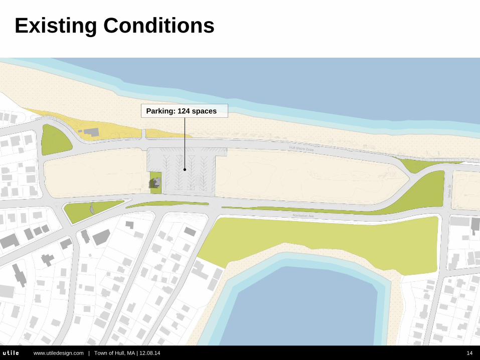
Existing Conditions
Parking: 124 spaces

www.utiledesign.com | Town of Hull, MA | 12.08.14 15
Phase One
Off-street: 71 spaces
On-street: 40 spaces
Total: 111 spaces
www.utiledesign.com | Town of Hull, MA | 12.08.14 16
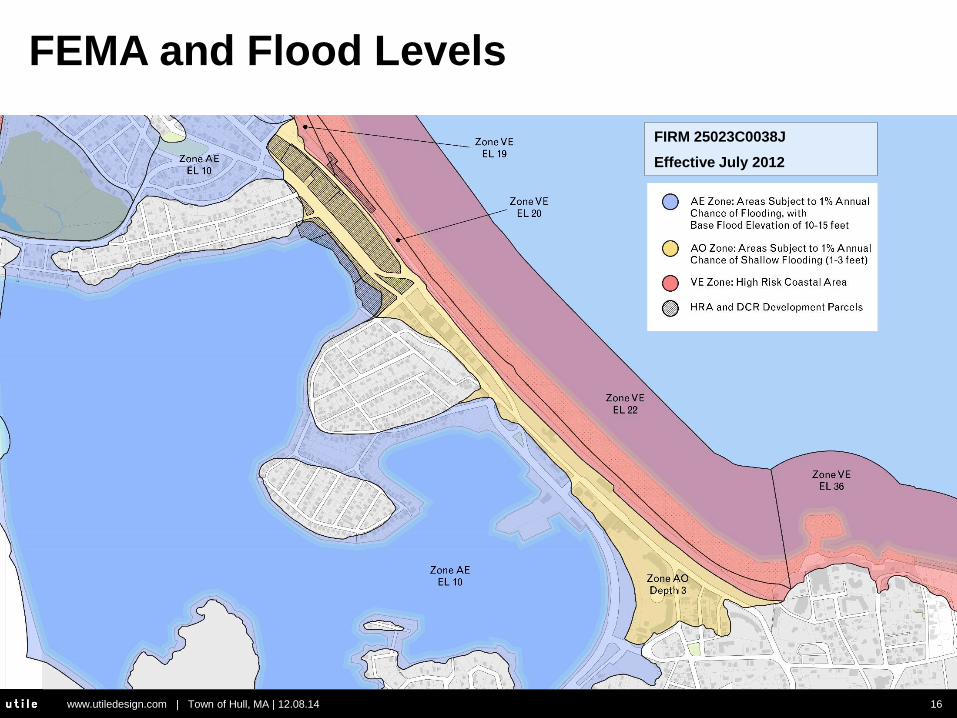
FEMA and Flood Levels
FIRM 25023C0038J
Effective July 2012

www.utiledesign.com | Town of Hull, MA | 12.08.14 17
Proposed Development Section
The development concept was developed
in collaboration with the Department of the
Massachusetts Office of Coastal Zone
management (CZM).

www.utiledesign.com | Town of Hull, MA | 12.08.14 18
Proposed Development Section

www.utiledesign.com | Town of Hull, MA | 12.08.14 19
Proposed Development Section

www.utiledesign.com | Town of Hull, MA | 12.08.14 20
Proposed Development Concept

www.utiledesign.com | Town of Hull, MA | 12.08.14 21
Cape May, New Jersey
Porches, Balconies, and Terraces

www.utiledesign.com | Town of Hull, MA | 12.08.14 22
8 units of Townhouse A
4 units of Townhouse B
36 units in the Condo Building*
48 units total*
*approximate based on an average of 1100 GSF/unit
Proposed Development Concept

www.utiledesign.com | Town of Hull, MA | 12.08.14 23
Proposed Development Concept

www.utiledesign.com | Town of Hull, MA | 12.08.14 24
Proposed Wind Mitigation

www.utiledesign.com | Town of Hull, MA | 12.08.14 25
Proposed Wind Mitigation
Wyoming Snow Fences
What’s That Thing: Roadside Fence Edition
By Mark Vanhoenacke
August 1, 2013
They’re not designed to “catch” blowing snow—in fact, they’re
not really a barrier at all in the traditional sense. Instead, the
slats of the fence slow down the wind as it passes through.
Slate Culture Blog

www.utiledesign.com | Town of Hull, MA | 12.08.14 26
Proposed Wind Mitigation
“Wind-dyed” hillside house by Japanese architect Kazuhiko
Kishimoto

www.utiledesign.com | Town of Hull, MA | 12.08.14 27
Proposed Wind Mitigation
Petting Farm, Almere, Netherlands, 70F, 2005-08
www.utiledesign.com | Town of Hull, MA | 12.08.14 28
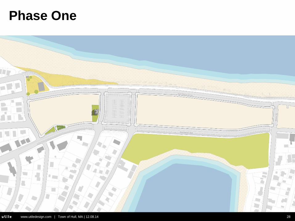
Phase One

www.utiledesign.com | Town of Hull, MA | 12.08.14 29
Phase Two

www.utiledesign.com | Town of Hull, MA | 12.08.14 30
Phase Three

www.utiledesign.com | Town of Hull, MA | 12.08.14 31
Scale Comparison – Hotel Development
Proposed Hotels: 148 keys
Existing Hotel: 105 keys

www.utiledesign.com | Town of Hull, MA | 12.08.14 32
Phase Three
www.utiledesign.com | Town of Hull, MA | 12.08.14 33
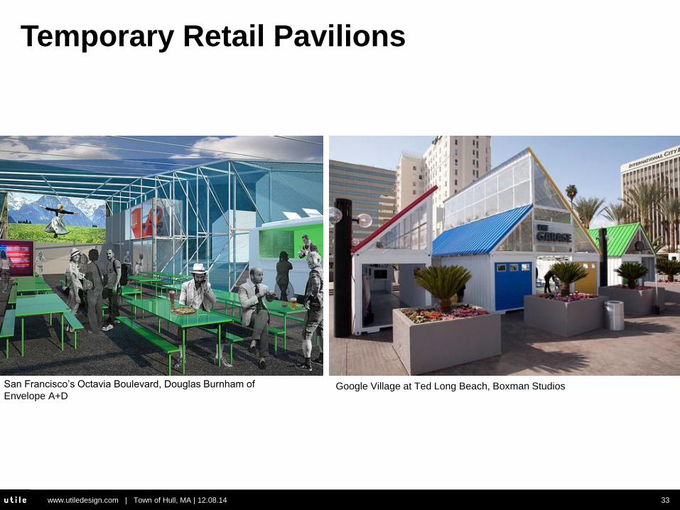
San Francisco’s Octavia Boulevard, Douglas Burnham of
Envelope A+D Google Village at Ted Long Beach, Boxman Studios
Temporary Retail Pavilions

www.utiledesign.com | Town of Hull, MA | 12.08.14 34
Temporary Retail Pavilions

www.utiledesign.com | Town of Hull, MA | 12.08.14 35
Phase Three

www.utiledesign.com | Town of Hull, MA | 12.08.14 36
Phase Four
Central Park
54,065 SF
1.24 acres
Bay Park
229,020 SF
5.26 acres

www.utiledesign.com | Town of Hull, MA | 12.08.14 37
Why Smaller Blocks?
• Increased connectivity
• Less circuitous walking/biking/transit
routes
• Facilitate mixed-use/ “park once”
environment – Shown to reduce driving*
www.utiledesign.com | Town of Hull, MA | 12.08.14 38
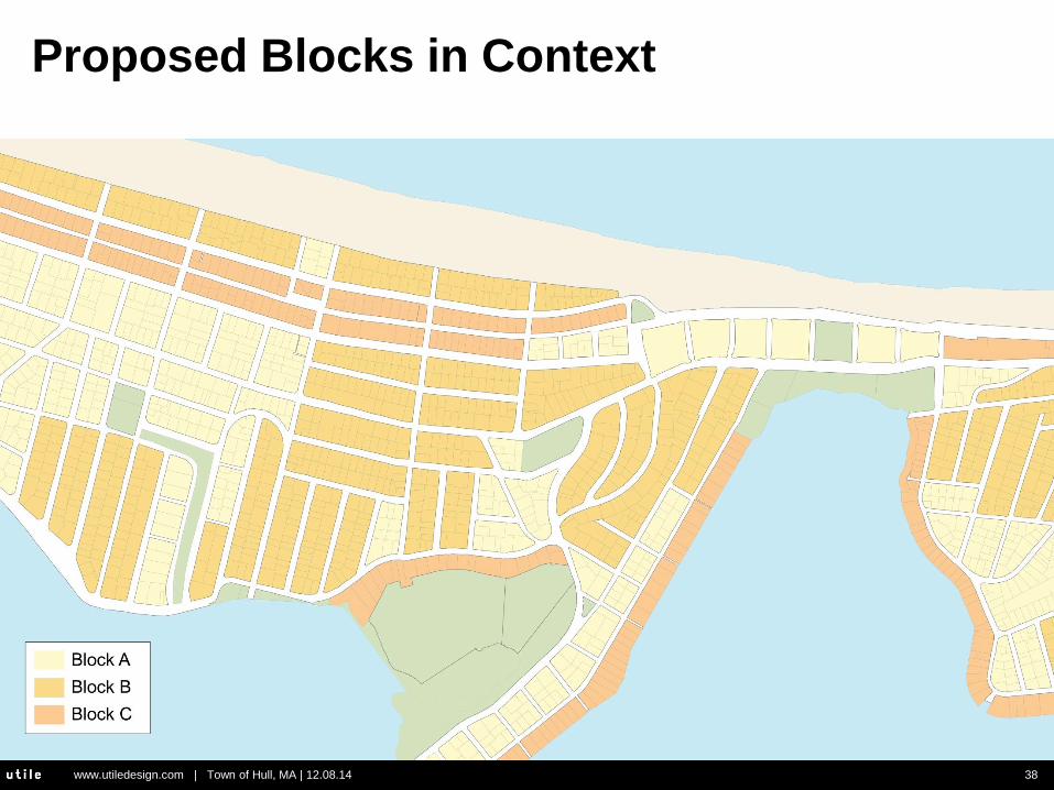
Proposed Blocks in Context
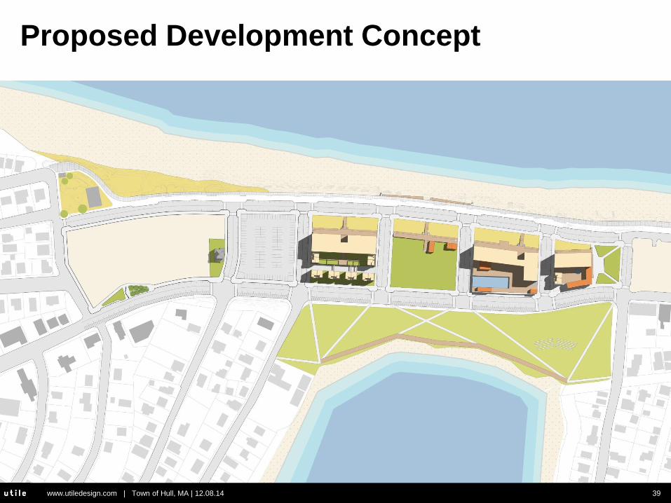
www.utiledesign.com | Town of Hull, MA | 12.08.14 39
Proposed Development Concept

www.utiledesign.com | Town of Hull, MA | 12.08.14 40
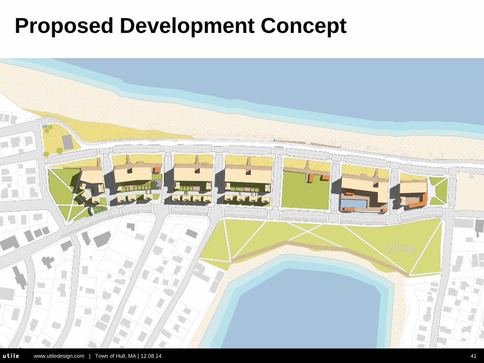
Proposed Development Concept
www.utiledesign.com | Town of Hull, MA | 12.08.14 41
Proposed Development Concept

www.utiledesign.com | Town of Hull, MA | 12.08.14 42
Open Space Summary
North Park
39,220 SF
“Dunescape”
49,142 SF
Central Park
54,065 SF
South Park
12,611 SF
Bay Park
229,020 SF
Boardwalks*
North Park
South Park
Central Park
Dunescape*
Bay Park
Total
*not including components
within Central Park
24,847 SF
39,220 SF
12,611 SF
54,065 SF
49,142 SF
229,020 SF
408,905 SF
Boardwalks
24,847 SF
0.90 acres
0.29 acres
1.24 acres
5.26 acres
**9.39 acres
** 2005 HRA Plan: 8 acres of
“open area” and a 4.5 acre
public park

www.utiledesign.com | Town of Hull, MA | 12.08.14 43
Proposed Development Concept

www.utiledesign.com | Town of Hull, MA | 12.08.14 44
Wildwood, New Jersey
Capturing View Corridors from New Streets
Recommended