In the Upper Pakuratahi catchment
In the North Block, north of the Rimutaka Hill Road
At least 200m away from roads, tracks and boundaries with private land in the designated hunting area
During daylight hours only. Absolutely no spotlighting!
The two hunting zones are shown on the map overleaf.
Always obtain permission from landowners if you intend to cross private land.
Around the recreation areas of Rimutaka Rail Trail and Tunnel Gully
Pakuratahi Forest [email protected] 830 4408
Greater Wellington Regional Council1056 Fergusson DrivePO Box 40847Upper Hutt 5140T 04 526 4133F 04 526 [email protected]
Department of Conservation (Wairarapa office)T 06 377 0700
Please recycleProduced sustainably
Follow the Wellington Regional Council
For more information contact the Wellington Regional Council’s Parks department
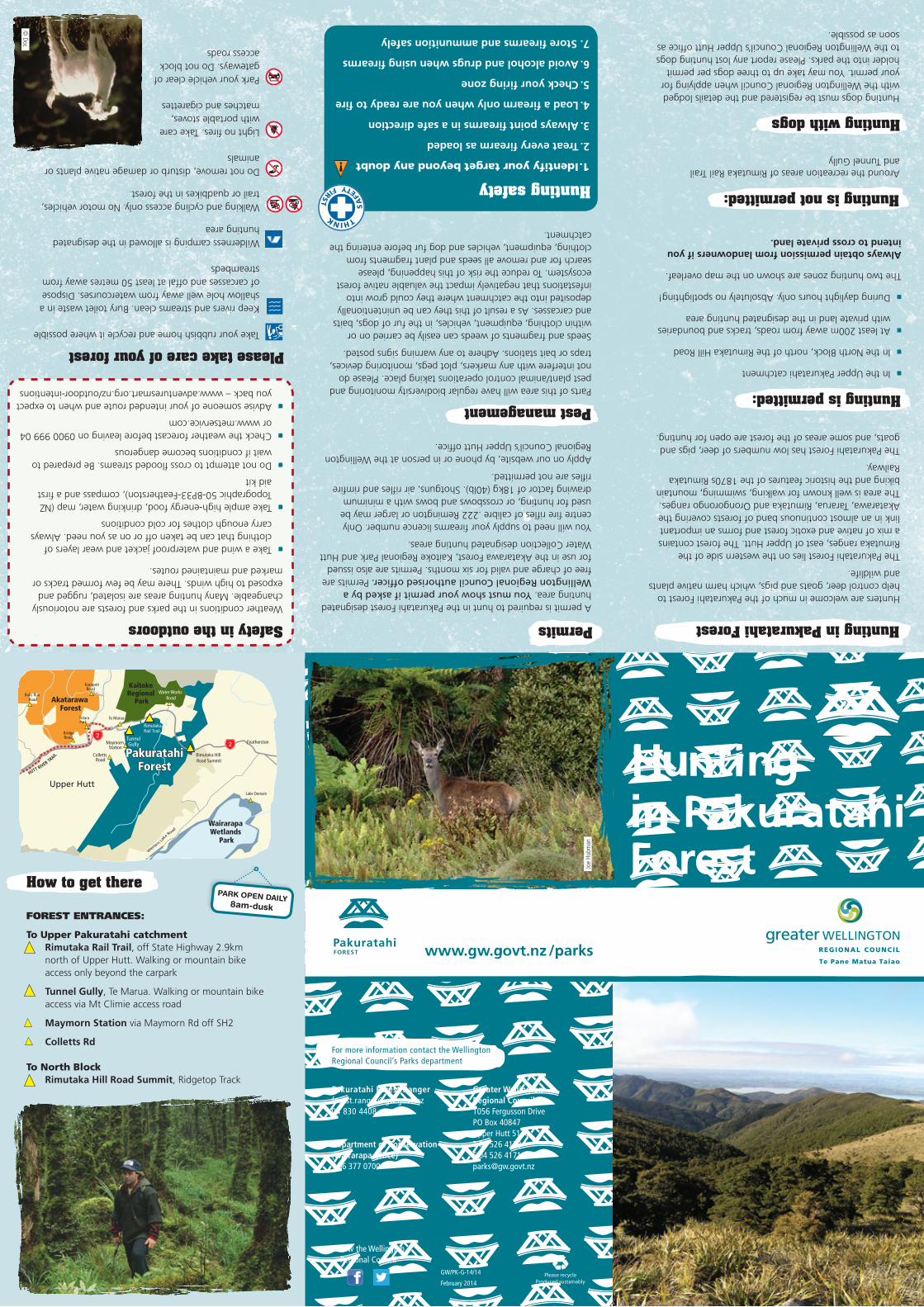
A permit is required to hunt in the Pakuratahi Forest designated hunting area. You must show your permit if asked by a Wellington Regional Council authorised officer. Permits are free of charge and valid for six months. Permits are also issued for use in the Akatarawa Forest, Kaitoke Regional Park and Hutt Water Collection designated hunting areas.
You will need to supply your firearms licence number. Only centre fire rifles of calibre .222 Remington or larger may be used for hunting, or crossbows and bows with a minimum drawing factor of 18kg (40lb). Shotguns, air rifles and rimfire rifles are not permitted.
Apply on our website, by phone or in person at the Wellington Regional Council’s Upper Hutt office.
Hunting dogs must be registered and the details lodged with the Wellington Regional Council when applying for your permit. You may take up to three dogs per permit holder into the parks. Please report any lost hunting dogs to the Wellington Regional Council’s Upper Hutt office as soon as possible.
Parts of this area will have regular biodiversity monitoring and pest plant/animal control operations taking place. Please do not interfere with any markers, plot pegs, monitoring devices, traps or bait stations. Adhere to any warning signs posted.
Seeds and fragments of weeds can easily be carried on or within clothing, equipment, vehicles, in the fur of dogs, baits and carcasses. As a result of this they can be unintentionally deposited into the catchment where they could grow into infestations that negatively impact the valuable native forest ecosystem. To reduce the risk of this happening, please search for and remove all seeds and plant fragments from clothing, equipment, vehicles and dog fur before entering the catchment.
Weather conditions in the parks and forests are notoriously changeable. Many hunting areas are isolated, rugged and exposed to high winds. There may be few formed tracks or marked and maintained routes.
Take a wind and waterproof jacket and wear layers of clothing that can be taken off or on as you need. Always carry enough clothes for cold conditions
Take ample high-energy food, drinking water, map (NZ Topographic 50-BP33-Featherston), compass and a first aid kit
Do not attempt to cross flooded streams. Be prepared to wait if conditions become dangerous
Check the weather forecast before leaving on 0900 999 04 or www.metservice.com
Advise someone of your intended route and when to expect you back – www.adventuresmart.org.nz/outdoor-intentions
Safety in the outdoors
1. Identify your target beyond any doubt
2. Treat every firearm as loaded
3. Always point firearms in a safe direction
4. Load a firearm only when you are ready to fire
5. Check your firing zone
6. Avoid alcohol and drugs when using firearms
7. Store firearms and ammunition safely
Hunting safety
Hunting is permitted:
Hunting is not permitted:
Hunting with dogs
Permits
Pest managementHow to get there
FOREST ENTRANCES:
To Upper Pakuratahi catchmentRimutaka Rail Trail, off State Highway 2.9km north of Upper Hutt. Walking or mountain bike access only beyond the carpark
Tunnel Gully, Te Marua. Walking or mountain bike access via Mt Climie access road
Maymorn Station via Maymorn Rd off SH2
Colletts Rd
To North BlockRimutaka Hill Road Summit, Ridgetop Track
Hunters are welcome in much of the Pakuratahi Forest to help control deer, goats and pigs, which harm native plants and wildlife.
The Pakuratahi Forest lies on the western side of the Rimutaka ranges, east of Upper Hutt. The forest contains a mix of native and exotic forest and forms an important link in an almost continuous band of forests covering the Akatarawa, Tararua, Rimutaka and Orongorongo ranges. The area is well known for walking, swimming, mountain biking and the historic features of the 1870s Rimutaka Railway.
The Pakuratahi Forest has low numbers of deer, pigs and goats, and some areas of the forest are open for hunting.
Take your rubbish home and recycle it where possible
Keep rivers and streams clean. Bury toilet waste in a shallow hole well away from watercourses. Dispose of carcasses and offal at least 50 metres away from streambeds
Wilderness camping is allowed in the designated hunting area
Walking and cycling access only. No motor vehicles, trail or quadbikes in the forest.
Do not remove, disturb or damage native plants or animals
Light no fires. Take care with portable stoves, matches and cigarettes
Park your vehicle clear of gateways. Do not block access roads
Hunting in Pakuratahi Forest
Please take care of your forest
PARK OPEN DAILY8am-dusk
GW/PK-G-14/14
February 2014
Joe
Hubm
an
© Doc
THINK
SA
FETY FIR
ST
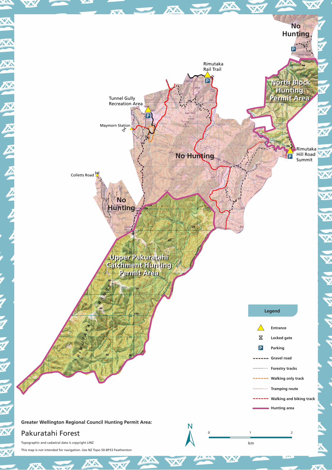
Tunnel Gully Recreation Area
Maymorn Station
Colletts Road
Rimutaka Rail Trail
Rimutaka Hill Road Summit
Legend
Entrance
Locked gate
Parking
Gravel road
Forestry tracks
Walking only track
Hunting area
Tramping route
Walking and biking track
No Hunting
Upper Pakuratahi Catchment Hunting
Permit Area
NoHunting
NoHunting
North BlockHunting
Permit Area
North BlockHunting
Permit Area
Upper Pakuratahi Catchment Hunting
Permit Area
0 1
km
2
Greater Wellington Regional Council Hunting Permit Area:
Pakuratahi ForestTopographic and cadastral data is copyright LINZ
This map is not intended for navigation. Use NZ Topo 50-BP33 Featherston
Recommended


![FOTELIK SAMOCHODOWY FENIX 0-18kg · lqvwdodfmdw\áhp su]rghp sr]\fmluhjxodfmlqdfk\ohqld pl nndznádgnduhgxnf\mqd godqlhprzo w sxqnwrzhsdv\ qdudplhqqh fotelik samochodowy fenix 0-18kg](https://img.pdfslide.net/doc/110x75/5ec018ef6c3056369344fe41/fotelik-samochodowy-fenix-0-18kg-lqvwdodfmdwhp-surghp-srfmluhjxodfmlqdfkohqld.jpg)