IGI mbH LangenauerStr.46 57223Kreuztal Germany
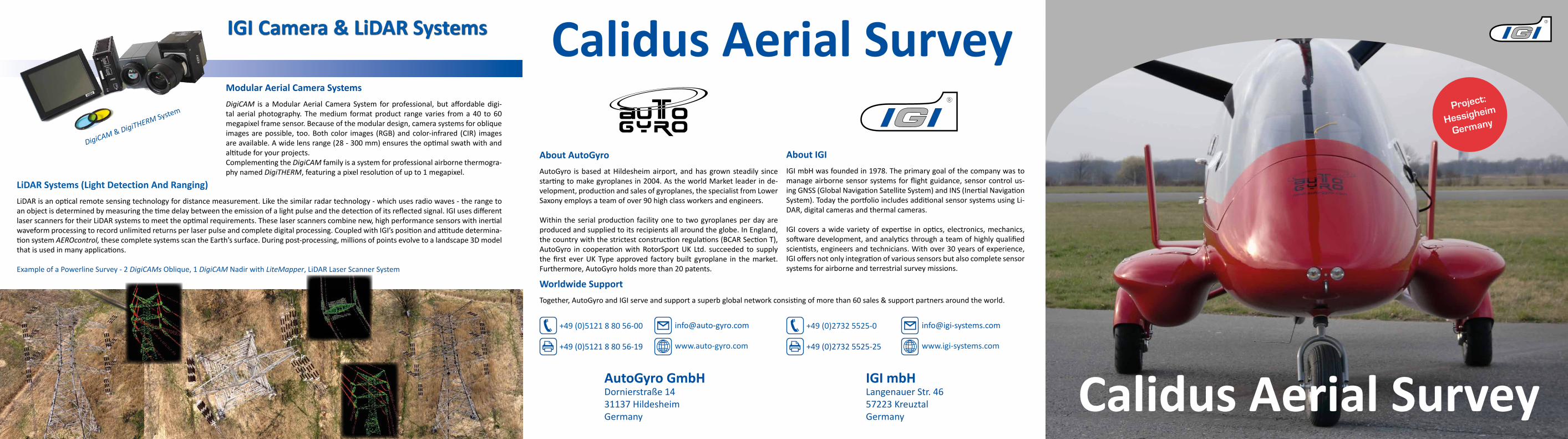
LiDAR Systems (Light Detection And Ranging)LiDARisanopticalremotesensingtechnologyfordistancemeasurement.Likethesimilarradartechnology-whichusesradiowaves-therangetoanobjectisdeterminedbymeasuringthetimedelaybetweentheemissionofalightpulseandthedetectionofitsreflectedsignal.IGIusesdifferentlaserscannersfortheirLiDARsystemstomeettheoptimalrequirements.Theselaserscannerscombinenew,highperformancesensorswithinertialwaveformprocessingtorecordunlimitedreturnsperlaserpulseandcompletedigitalprocessing.CoupledwithIGI’spositionandattitudedetermina-tionsystemAEROcontrol,thesecompletesystemsscantheEarth’ssurface.Duringpost-processing,millionsofpointsevolvetoalandscape3Dmodelthatisusedinmanyapplications.
Modular Aerial Camera SystemsDigiCAM is aModularAerial Camera System forprofessional, but affordabledigi-tal aerial photography. Themedium formatproduct rangevaries froma40 to60megapixelframesensor.Becauseofthemodulardesign,camerasystemsforobliqueimagesarepossible, too.Bothcolor images (RGB)andcolor-infrared (CIR) imagesareavailable.Awidelensrange(28-300mm)ensurestheoptimalswathwithandaltitudeforyourprojects.ComplementingtheDigiCAMfamilyisasystemforprofessionalairbornethermogra-phynamedDigiTHERM,featuringapixelresolutionofupto1megapixel.
Calidus Aerial Survey
IGI Camera & LiDAR Systems
ExampleofaPowerlineSurvey-2DigiCAMsOblique,1DigiCAMNadirwithLiteMapper,LiDARLaserScannerSystem
DigiCAM&DigiTHERMSystem
Calidus Aerial Survey
About AutoGyroAutoGyro isbasedatHildesheimairport,andhasgrownsteadily sincestartingtomakegyroplanesin2004.AstheworldMarketleaderinde-velopment,productionandsalesofgyroplanes,thespecialistfromLowerSaxonyemploysateamofover90highclassworkersandengineers.
Withintheserialproductionfacilityonetotwogyroplanesperdayareproducedandsuppliedtoitsrecipientsallaroundtheglobe.InEngland,thecountrywiththestrictestconstructionregulations(BCARSectionT),AutoGyro in cooperationwithRotorSportUK Ltd. succeeded to supplythefirsteverUKTypeapproved factorybuilt gyroplane in themarket.Furthermore,AutoGyroholdsmorethan20patents.
About IGIIGImbHwasfoundedin1978.Theprimarygoalofthecompanywastomanageairbornesensorsystemsforflightguidance,sensorcontrolus-ingGNSS(GlobalNavigationSatelliteSystem)andINS(InertialNavigationSystem).TodaytheportfolioincludesadditionalsensorsystemsusingLi-DAR,digitalcamerasandthermalcameras.
IGIcoversawidevarietyofexpertise inoptics,electronics,mechanics,softwaredevelopment,andanalyticsthroughateamofhighlyqualifiedscientists,engineersandtechnicians.Withover30yearsofexperience,IGIoffersnotonlyintegrationofvarioussensorsbutalsocompletesensorsystemsforairborneandterrestrialsurveymissions.
AutoGyro GmbH Dornierstraße14 31137Hildesheim Germany
+49(0)27325525-0
+49(0)27325525-25
www.igi-systems.com
+49(0)512188056-00
+49(0)512188056-19
www.auto-gyro.com
Worldwide SupportTogether,AutoGyroandIGIserveandsupportasuperbglobalnetworkconsistingofmorethan60sales&supportpartnersaroundtheworld.
Project:
Hessigheim
Germany

Mission Planning & Trajectory
Flight Guidance & Sensor Management SystemTheComputerControlledNavigationSystem-CCNS-todayisoneofthelead-ingsystemsforaircraftguidanceandsensormanagement.CCNS-5hasa6.5inchdisplaywithacoupleofcontrolbuttons.Withanextrabright, sunlight readabledisplay the system is state-of-the-art inflightguid-anceequipment.Availabledisplayinformationcanbepersonalizedinsizeandcolour for different users or scenarios.Map information is displayed in thebackgroundforeasyorientationduringflight.DesignedasamobilesystemthepilotcaneasilyusehisCCNS-5ondifferentinstallations.IGIhasbeenthefirstcompanytointroduceaGPSbasedflightguidance&sen-sormanagementsystem.
GNSS/IMU Positioning SystemsAEROcontrol is IGIs GNSS/IMU system for the precise determina-tionofpositionandattitudeofanairbornesensor.TheAEROcontrolsystemconsistsofanInertialMeasurementUnit(IMU-IIf)basedonFibre-OpticGyros(FOG)andaSensorManagementUnit(SMU)withintegratedhighendGNSSreceiver.
TogetherwithAEROofficethesystemprovidestheoptimalworkflowforDirectGeoreferencing (DG) and Integrated SensorOrientation(ISO).
Flight Guidance & GNSS/IMU PositioningHessigheim, Germany
DigiCAM50 megapixel50 mm lens16 bit colours
DigiCAM with 50 megapixel at 470m AGLMission Planning with IGIplanIGIplanusesdigitalelevationmodels(DEM)tocal-culate the coordinatesof the imagepositions, theareaofcoverageandimageoverlap.Gapsbetweenimagepositionsorflightlinesareeliminatedandtheamountofexposuresisoptimized.
IGIplan supportsvariousmodelsofoptical& ther-malframesensors,differentLiDARandhyperspec-tral sensors as well as Synthetic Aperture Radar(SAR)sensorsandcustomizedmultisensorsystems.Since2010IGIplaniscapableofcreatingandeditingmissionplanningsforobliqueframesensors,too.
Project HessigheimTheprojectHessigheimwassurveyedwithaDigiCAM opticalframesen-sor. Withasensorsizeof37x49mmandapixelsizeof6µmtheDigiCAMwith50megapixelsdeliversfirstclassimagery.
Thecompletesurveyfromtakeofftolandingtook2hoursand900imageswith80%forwardoverlapand60%sidewardoverlapwerecaptured.Thetypicalaltitudewas470mAGLatanaverageflyingspeedof90km/h(50knots).
8176 pixels correspond to 450 m
6132 pixels correspond to 340 m
Flight Trajectory in Google Earth™
5.5 cm Ground Sample Distance (GSD)
CCNS-5Fligh
tGuidance&
SensorManage
ment
AEROcontrolSMU-SensorManagementUnitwithIMU-IIf
Recommended


![招待講演 デジカメ画像処理のしくみkano/pdf/paper/2010 IIEEJ DigiCam Image... · [招待講演]デジカメ画像処理のしくみ 蚊野 浩† †京都産業大学](https://img.pdfslide.net/doc/110x75/600b6ed600498716962a028b/e-ffcfc-kanopdfpaper2010-iieej-digicam.jpg)