Integrated Strategic Environmental Assesment of the Northern Province of Sri Lanka (ISEA - North) lessons learnt report

ISEA-North Lessons Learnt Report
Page | i
Integrated Strategic Environment Assessment for the Northern Province (ISEA-North)
Lessons Learnt Report
ISBN: 978-955-0205-46-2
First Edition: August 2017
@ Editors:
Dr. Ananda Mallawatantri Ms. Sandamali Pathirage Published by: IUCN Sri Lanka 53, Horton Place Colombo 07
ISEA – North was conducted under the leadership of the Central Environmental Authority (CEA) and
Disaster Management Centre (DMC) with the participation of key stakeholder agencies, supported by
the United Nations Development Programme (UNDP) and United Nations Environment Programme
(UNEP).
This lessons learnt report was compiled by the International Union for Conservation of Nature (IUCN)
and United Nations Environment Programme (UNEP). Key agencies participated in the ISEA-North
process provided inputs to this report. Review support was provided by Ms. Marisol Estrella,
Programme Coordinator, UNEP, Dr. Karen Sudmeier, Consultant, UNEP and Ms Krishani Peiris at IUCN
Sri Lanka.

ISEA-North Lessons Learnt Report
Page | ii
Contents List of Tables .......................................................................................................................................... iii
List of Figures ......................................................................................................................................... iii
List of Acronyms ..................................................................................................................................... iv
Preface ................................................................................................................................................ v
Executive Summary ............................................................................................................................ vi
1. Introduction .................................................................................................................................... 1
1.1. Government Initiative .................................................................................................................. 2
1.2. Modifying the SEA Approach ....................................................................................................... 2
1.3. ISEA in the Post-Conflict Context ................................................................................................. 3
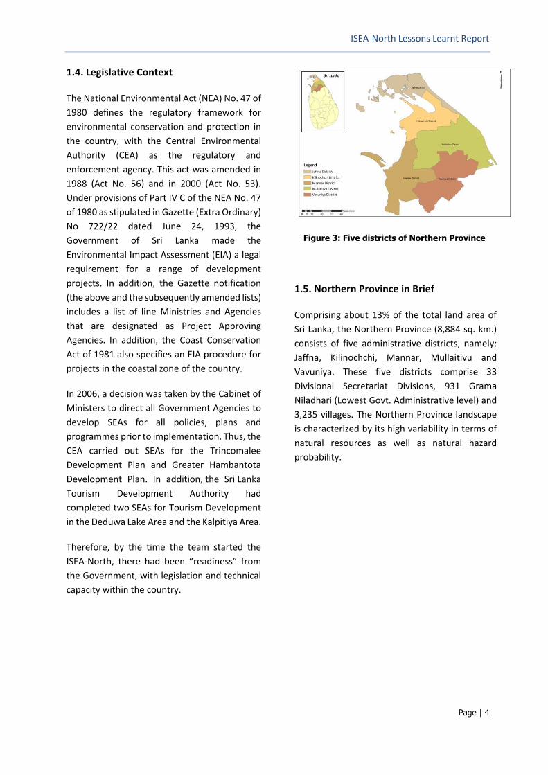
1.4. Legislative Context ....................................................................................................................... 4
2. ISEA-North Process ......................................................................................................................... 5
2.1. Initiation ....................................................................................................................................... 5
2.2. Initial Fact-Finding Mission .......................................................................................................... 5
2.3. Findings of the First Visit .............................................................................................................. 5
2.4. ISEA development ........................................................................................................................ 6
2.5. Baseline Phase ............................................................................................................................. 7
2.6. Development Phase ................................................................................................................... 10
2.7. Assessment Phase ...................................................................................................................... 11
3. Opportunity Map .......................................................................................................................... 15
3.1. Development Scenarios ............................................................................................................. 16
4. Specific Applications of the ISEA-North ........................................................................................ 21
5. Lessons from the ISEA Process ...................................................................................................... 25
5.1. Agency Co-operation ................................................................................................................. 25
5.2. Political Authority Support ......................................................................................................... 25
5.3. International Inputs ................................................................................................................... 25
5.4. Baseline Information Generation............................................................................................... 25
5.5. Environment for Decision-Making ............................................................................................. 26
5.6. Support to Development Partners ............................................................................................. 27
5.7. Logistics and safety .................................................................................................................... 27
6. Lessons from ISEA Implementation: Five Years After ................................................................... 28
6.1. Slow Adoption of ISEA ................................................................................................................ 28
6.2. Extent of International Assistance ............................................................................................. 28
6.3. Political Will for Implementation ............................................................................................... 29
6.4. Advocacy Needs ......................................................................................................................... 29
6.5. Traditional vs. prescribed land uses ........................................................................................... 30
6.6. District Level Experience ............................................................................................................ 30
7. Conclusions ................................................................................................................................... 33
7.1. Key Observations ....................................................................................................................... 33
7.2. Way Forward .............................................................................................................................. 33
8. References .................................................................................................................................... 34

ISEA-North Lessons Learnt Report
Page | iii
List of Tables
Table 1: Key ISEA related statistics in the Northern Province Districts ................................................ 16
Table 2: Likely effects of Business as Usual Scenario on the SEIs ......................................................... 18
Table 3: Likely effect of Conservation Scenario .................................................................................... 19
Table 4: Likely effect of Development Scenario with Management ..................................................... 20
List of Figures
Figure 1: At the end of 30 years of armed conflict ................................................................................. 1
Figure 2: EIA and SEA processes ............................................................................................................. 3
Figure 3: Five districts of Northern Province .......................................................................................... 4
Figure 4: First fact finding mission in November 2009 ........................................................................... 5
Figure 5: ISEA-North agency structure .................................................................................................... 6
Figure 6 : Water bodies ........................................................................................................................... 8
Figure 7: Forest cover ............................................................................................................................. 8
Figure 8: Minerals ................................................................................................................................... 9
Figure 9: Archaeological sites ................................................................................................................. 9
Figure 10: Periodic consultations at District Level Jaffna, 2010 ........................................................... 10
Figure 11: Proposed development initiatives ....................................................................................... 11
Figure 12: Proposed combined forest and wildlife conservation areas ............................................... 12
Figure 13: Prioritized mineral extraction .............................................................................................. 13
Figure 14: Disaster potentials including climate change on development projects ............................. 14
Figure 15: Opportunity Map of areas with Minimum Environment Concerns ..................................... 15
Figure 16: Team Leader ISEA-North, Prof. Buddhi Marambe on Sri Lanka experience ........................ 23
Figure 17: Team Nepal plans to adopt ISEA experience in post-earthquake reconstruction ............... 23
Figure 18: Nepal, Cote d'Ivore and UNEP team with Northern Provincial Minister of Environment ... 23
Figure 19: Examining the potential multi-stakeholder approaches to port St. Pedro project ............. 24
Figure 20: Inauguration ceremony of ISEA-North ................................................................................. 29

ISEA-North Lessons Learnt Report
Page | iv
List of Acronyms
ADB Asian Development Bank
AusAID Australian Agency for International Development
CEA Central Environmental Assessment
DIA Disaster Impact Assessment
DMC Disaster Management Centre
DWLC Department of Wild Life Conservation
EIA Environmental Impact Assessment
ESDR Environment Sustainability and Disaster Resilience
GIS Geographic Information System
GSMB Geological Survey and Mines Bureau
IDP Internally displaced persons
ISEA Integrated Strategic Environmental Assessment
IUCN International Union for Conservation of Nature
JICA Japan International Cooperation Agency
LLRC Lessons Learnt and Reconcilation Commission
NCP North Central Province
NEA National Environmental Act
NWS&DB National Water Supply and Drainage Board
PTF Presidential Task Force
SCDP Strategic Cities Development Project
SDG Sustainable Development Goals
SEA Strategic Environmental Assessment
SEO Strategic Environment Objectives
UDA Urban Development Authority
UNDP United Nations Development Programme
UN Environment United Nations Environment Programme
UNHCR United Nations High Commissioner for Refugees
WB/IFC World Bank/International Finance Corporation
WRMP Western Region Megapolis Planning

ISEA-North Lessons Learnt Report
Page | v
Preface
Integration of environmental sustainability
and disaster resilience, including climate
concerns, is an important and challenging
aspect in post-conflict or post-disaster
development and reconstruction towards
“building back better.” Such opportunities
also provide Governments and development
partners options to adopt systematic
multi-sector and multi-stakeholder inclusive
approaches based on informed planning tools
to ensure the protection of natural, cultural
and heritage resources during the
reconstruction phase. In parallel, such
approaches can be used to incorporate
climate and disaster risk considerations
more effectively.
This was the post-conflict and post-disaster
challenge faced by the Government of
Sri Lanka, at the end of a 30-year long
protracted armed conflict that devastated the
Northern Province of Sri Lanka. Over 330,000
displaced people had to be resettled.
The coastal belt of the Northern Province had
also been heavily impacted previously by the
2004 Indian Ocean Tsunami.
UN Development Programme and UN
Environment joined forces with several
Government Ministries/Agencies to develop a
framework for the sustainable and resilient
reconstruction of the Northern Province.
This approach was named the “Integrated
Strategic Environment Assessment for the
Northern Province of Sri Lanka” (ISEA-North).
The ISEA-North started in the latter part of
2009 was completed in 2012 while the final
report was released in 2014. The maps, data
and recommendations were made available to
agencies from the inception as
an when the materials were ready, to help the
reconstruction process in the Northern
Province.
Five years after the implementation of the
ISEA-North in Sri Lanka, UN Environment is
implementing a new project with the support
of IUCN Sri Lanka to learn from the ISEA
process in the country, where it originated.
The aim is to share the ISEA experience within
Sri Lanka so that the full use of ISEA-North
could be realized. At the same time the project
is planning to strengthen national capacities to
implement ISEAs in two other countries: Cote
d’Ivoire and Nepal.
Funded through the UN Development Account
as a two-year south-south cooperation, this
initiative, “Enabling sustainable and resilient
development planning in post-crisis countries
by mainstreaming environment and risk
reduction into development planning (2015-
2017)”, was developed with the objective to
share best practices and challenges faced
when applying ISEAs among the three
countries and in two regions, Africa and Asia.
This report summarises the material collected
by IUCN Sri Lanka on the ISEA experience in
Sri Lanka in the form of a case study. Initial
findings were shared and validated at national
and district levels. The material presented
needs to be referenced along with the Final
ISEA-North Report (https://goo.gl/kJRV5N) and
the “Map Compendium “ that comprises of a
full set of maps related to the ISEA-North
process (https://goo.gl/YcwFbq).

ISEA-North Lessons Learnt Report
Page | vi
Executive Summary
This report discusses the lessons that emerged
during the development and implementation
of the “Integrated Strategic Environment
Assessment for the Northern Province
(ISEA-North)”, which was developed as a
planning tool to mainstream environment
sustainability and disaster resilience in the
post-conflict development of the Northern
Province in Sri Lanka. The active participation
of key stakeholder agencies provided the
“integration” ability.
The ISEA-North, which started in November
2009 was completed in 2014, to support the
“building back better” process by saying “yes”
to development, but with adequate
environmental “safeguards.” The multi-sector
and multi-stakeholder approach used in the
ISEA-North was considered as a replicable
model for post-conflict/disaster recovery
programmes by the United Nations. In 2015,
the UN Development Account allocated funds
to UN Environment and IUCN to document the
ISEA-North experience, several years later.
In Sri Lanka, the context it is revisiting the
ISEA-North implementation experience is to
improve future actions and designs of any new
efforts.
Among the key findings, it was clear that the
joint leadership provided by the Central
Environment Authority (CEA) and the Disaster
Management Centre (DMC) made it possible
to combine environment management
and disaster resilience in the Northern
development and to access the support from
UNDP and UNEP.
The systematic approach was well received in
the country during the ISEA-North formulation,
and covered three phases: (i) the baseline
phase (generating and combining old and new
information); (ii) the development phase
(compiling proposed development plans,
reviewing potential conflicts between
development and conservation, adding
disaster potentials including climate change)
and; (iii) the assessment phase (agencies
together prioritizing land uses, discussing
constraints on different options and agreeing
on optimal land uses). It is a unique and
a challenging approach after a massive
disturbance. The “Opportunity Map”, one of
the key products of ISEA-North is an effective
tool for decision making and project approvals.
The ISEA frequently competed with the notion
to rebuild fast and resettle the affected.
As such, ISEA process continuously engaged
decision makers to explain the value and
progress. It worked well at the national level
including the endorsement by the Presidential
Task Force (PTF) for rebuilding North.
ISEA-North information was used extensively
at the national level in declaring archaeological
sites, national parks, location of resettlements
and cities, etc. This success led to the adoption
of the ISEA approach to one of the largest
developments, namely, the “Western Region
Megapolis Planning.”
Mainstreaming of ISEA – North findings and
recommendation at district and provincial
levels was less than expected, partly due to the
inability to legalize the ISEA-North
recommendations. Targeted advocacy and
engagement of senior Government officials
and policy makers on ISEA and staff capacity
building were two key factors contributed for
less adoption of ISEA. Continued training and
capacity development may have improved the
success of ISEA-North. Nevertheless, even in
year 2016, the ISEA-North materials are
considered useful by district level officials.
They recognize the value of ISEA outputs in the
post conflict period to ensure sustainability
and resilience of affected populations.

ISEA-North Lessons Learnt Report
Page | 1
1. Introduction
In May 2009, following the cessation of
over 30 years of conflict in Sri Lanka,
there was significant need and political
pressure to jump-start the reconstruction
and development process in the Northern
Province of the country and to
deliver immediate development benefits to
the affected communities. Along with the
urgency of reconstruction, including
resettlement of displaced populations, it was
recognized that reconstruction and new
development should not cause negative
environmental impacts and jeopardize the
long-term sustainability of development in
the Northern Province. Moreover, new
development offered an opportunity to
incorporate nature-based solutions and
disaster resilience considerations in planning.
The proposed rapid resettlement and
development included investments in
infrastructure, roads, railways, tele-
communications, among others, as well
as restoring public administration and
planning systems to stimulate investment and
growth.
This rapid development also brought new
challenges to natural resource availability, its
priority uses and long-term sustainability.
For example, the provisioning of sufficient
volumes of ground- and surface water for
industry and resettlements as well as sourcing
of building materials required a high level of
attention towards the protection of ecosystem
services and nature, culture and heritage upon
which livelihoods in this region are based.
This situation also demanded rapid decision-
making in the context of post-conflict
reconstruction. At the same time, there
was a need for a technically sound, multi-
sectoral and multi-stakeholder approach
to facilitate implementation of the proposed
projects without compromising environmental
sustainability and resilience. The Integrated
Strategic Environment Assessment for the
Northern Province (ISEA-North) provided an
approach to address these challenges.
Figure 1: At the end of 30 years of armed conflict

ISEA-North Lessons Learnt Report
Page | 2
1.1. Government Initiative
Immediately after the end of the war in 2009,
the Government of Sri Lanka initiated an
accelerated development programme to
support reconstruction in the Northern
Province, which was referred to as the
‘Northern Spring’ (‘Uthuru Wasanthaya’ in
Sinhala and ‘Wadakkin Wasantham’ in Tamil).
An influential Presidential Task Force (PTF) was
appointed to coordinate the reconstruction
and development work under the leadership
of the Hon. Minister of Economic Development.
Most of the areas were severely land-mined,
and the security threat was considered high.
Military presence in the province had
been prominent. Field work for any data
generation required the permission of the
Government and needed to be undertaken with
extreme care due to land mines. With the
exception of the Jaffna District, the Provincial
Government Administrative System and social
support structure were not functioning well.
A decision was taken by the Government to
resettle over 330,000 Internally Displaced
Persons (IDPs), as soon as possible, partly due
to the international pressure to move people
out of camps.
Entry to the ISEA-North formulation was based
on the Government’s 180-day plan to address
post-conflict needs. In the plan, the Central
Environmental Authority (CEA) proposed a
Strategic Environmental Assessment (SEA) for
the Northern Province to ensure sustainability
of development, while the Disaster
Management Centre (DMC) of the Ministry of
Disaster Management proposed a Disaster
Impact Assessment to be undertaken in the
North. Both proposals were integrated in the
work of these two agencies conducted in the
“Manik Farm”, the camp that held over 330,000
IDPs, following the last battle in the North. UN
Development Programme (UNDP) played a key
role in supporting the IDP management in the
Manik Farm by providing management support
to the UN High Commissioner for Refugees
(UNHCR) on drainage, sewage and waste
management. UNDP was also interested in
supporting the resettlement process of IDPs, as
its core development mandate.
In this context, the Environment, Energy and
Disaster Risk Management Programme of
UNDP Sri Lanka agreed to work with the CEA
and DMC and highlighted the need to
mobilize development and conservation
agencies towards a consultative process that
was also sensitive to the post-conflict landscape
in the Northern Province.
Discussions with the Ministry of Economic
Development (then Ministry of Nation
Building), Presidential Task Force for the
Northern Province and the UN Environment
Asia-Pacific Office resulted in the joint UNDP-
UN Environmental technical assistance to
support the ISEA process in the Northern
Province, in collaboration with the Government
of Sri Lanka. The CEA, DMC and the Urban
Development Authority served as lead
Government Agencies in the ISEA process.
1.2. Modifying the SEA Approach
Strategic Environmental Assessments (SEAs)
refer to the environmental assessment of plans,
programmes and other strategic actions, which
help determine where and how individual
projects can take place. The SEA is a systematic
process of predicting and evaluating the likely
environmental effects of a proposed policy,
plan or a programme. It seeks to address
environmental sustainability and disaster
resilience concerns at the earliest stages of
development planning, to support sound land-
use and investment decision-making, in
tandem with economic, social and other
considerations.

ISEA-North Lessons Learnt Report
Page | 3
The SEA employs a range of “analytical and
participatory approaches to integrate
environmental considerations into policies,
plans and programmes and to evaluate the
inter-linkages with economic and social
considerations”1. A good SEA is adapted and
tailor-made to the context in which it is applied.
SEA processes are often based on available
baseline data.
In the case of the Northern Province, the data
availability, after a 30-year conflict, was
considered inadequate. Moreover, there was
intense political pressure to re-start
reconstruction and facilitate development
dividends to affected communities.
A modification to the SEA approach was
therefore warranted, which led to the
development of an Integrated Strategic
Environmental Assessment (ISEA) approach,
which was tailored to the post-conflict context
and reconstruction needs of the Northern
Province. The ISEA process involved data
integration, data gap filling and stakeholder co-
ordination, working to systematically assess
different plans and strategies in a specific area.
The purpose of the ISEA for the Northern
Province was to bring key stakeholder entities
together, consolidate both environmental
baseline and development information, and
introduce a sound basis for participatory,
scientific and informed decision-making on land
and natural resource uses. The aim of the ISEA
was to ensure that the rebuilding process was
sustainable and resilient to disasters and
climate risks.
1.3. ISEA in the Post-Conflict Context
In a post-conflict situation, it can be crucial to
provide assurance that robust environmental
assessments are in place—so that new
1 OECD (2006): Applying Strategic Environmental
Assessment – Good Practice Guidance for Development
developments can be facilitated as quickly as
possible. Consideration of environmental
effects at early stages of development/
reconstruction planning through an ISEA
process can help minimize negative
environmental impacts from development
activities. By assessing the higher-level
environmental impacts of multiple
development plans/programmes in a given
area, the ISEA can also help prioritize when
Environmental Impact Assessments (EIAs) for
individual projects may be needed, thus
increasing the efficiency of the EIA process.
It should be noted that the impacts arising from
proposed individual projects are also likely to be
reduced because they have the benefit of being
already directed towards the most sustainable
areas in the first place, as a result of the ISEA
information.
While EIAs and SEAs protect the environment
by ensuring that projects and plans
are informed by environmental baseline
information and consensual decision-making,
ISEAs may be distinguished based on its time-
bound element. Typically undertaken in a post-
crisis context, the process of preparing the ISEA
baseline and proposed development maps
itself, over a short period, creates the
conditions for multi-stakeholder dialogue and
decision-making.
Figure 2: EIA and SEA processes
Cooperation. 160 pp. Organization for Economic Cooperation
and Development, France.
ISEA-North Lessons Learnt Report
Page | 4
1.4. Legislative Context
The National Environmental Act (NEA) No. 47 of
1980 defines the regulatory framework for
environmental conservation and protection in
the country, with the Central Environmental
Authority (CEA) as the regulatory and
enforcement agency. This act was amended in
1988 (Act No. 56) and in 2000 (Act No. 53).
Under provisions of Part IV C of the NEA No. 47
of 1980 as stipulated in Gazette (Extra Ordinary)
No 722/22 dated June 24, 1993, the
Government of Sri Lanka made the
Environmental Impact Assessment (EIA) a legal
requirement for a range of development
projects. In addition, the Gazette notification
(the above and the subsequently amended lists)
includes a list of line Ministries and Agencies
that are designated as Project Approving
Agencies. In addition, the Coast Conservation
Act of 1981 also specifies an EIA procedure for
projects in the coastal zone of the country.
In 2006, a decision was taken by the Cabinet of
Ministers to direct all Government Agencies to
develop SEAs for all policies, plans and
programmes prior to implementation. Thus, the
CEA carried out SEAs for the Trincomalee
Development Plan and Greater Hambantota
Development Plan. In addition, the Sri Lanka
Tourism Development Authority had
completed two SEAs for Tourism Development
in the Deduwa Lake Area and the Kalpitiya Area.
Therefore, by the time the team started the
ISEA-North, there had been “readiness” from
the Government, with legislation and technical
capacity within the country.
Figure 3: Five districts of Northern Province
1.5. Northern Province in Brief
Comprising about 13% of the total land area of
Sri Lanka, the Northern Province (8,884 sq. km.)
consists of five administrative districts, namely:
Jaffna, Kilinochchi, Mannar, Mullaitivu and
Vavuniya. These five districts comprise 33
Divisional Secretariat Divisions, 931 Grama
Niladhari (Lowest Govt. Administrative level) and
3,235 villages. The Northern Province landscape
is characterized by its high variability in terms of
natural resources as well as natural hazard
probability.

ISEA-North Lessons Learnt Report
Page | 5
2. ISEA-North Process
2.1. Initiation
Based on a preliminary literature review, UNDP
Sri Lanka’s Environment Sustainability and
Disaster Resilience (ESDR) team learned
UN Environment has experience on post-
conflict environmental assessments. A joint
collaboration was established between UNDP
Sri Lanka and UN Environment to provide
technical assistance to the Government of
Sri Lanka.
2.2. Initial Fact-Finding Mission
A fact-finding or scoping mission to the
Northern Province in November 2009
comprised of UNDP, an expert from UN
Environment, and representatives from the
CEA and DMC. This trip marked the first
overland UN mission to the Northern Province.
At that time, buildings were bullet-ridden, and
the infrastructure, including roads, were
completely damaged. There were multiple
military check points, and land mines were
marked by yellow coloured signs.
The Presidential Task Force (PTF) for
coordinating the Northern Province
development gave authorization for this first
scoping mission. The Sri Lanka Army assisted
the team to travel to the Northern Point of the
Peninsula and then south via the Eastern Coast,
which was heavily land-mined, but very rich in
scenic beauty.
2.3. Findings of the First Visit
The team met with the District Secretaries of
Jaffna, Kilinochchi, Mannar, Mullaitivu, and
Vavuniya and the key Government District
staff were present at the meetings as well.
The District Secretary’s office of the Mullaitivu
District was functioning in Vavuniya, as
infrastructure in Mullaitivu was badly
damaged.
Discussions indicated the need to fill several
data gaps, including the need to conduct field
studies on the current status of natural
resources. Capacity development needs
of District Government offices (including
the District planning units) were also
identified.
As most of the Northern Province population,
at the time of the first visit, lived in the
Manik Farm IDP camp, it was not possible
to speak with community members during
the mission. In addition, some of the
Government sector agencies were not fully
present in the districts. For example, the
Wildlife Department functioned from an office
in Vavuniya.
The fact-finding tour enabled the team
to assess the current situation before
post-conflict resettlement and development
process was initiated. All five districts led by
District Secretariats endorsed the need to
carry out an information-based planned
management approach for the re-development
and reconstruction of the Northern Province.
Figure 4: First fact finding mission in
November 2009
ISEA-North Lessons Learnt Report
Page | 6
Findings of the mission were summarised by
UNDP and reported to the Government
Agencies in Colombo, including the PTF and UN
agencies. The Government and UN system fully
endorsed the rationale of the ISEA process.
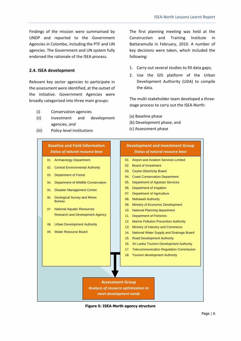
2.4. ISEA development
Relevant key sector agencies to participate in
the assessment were identified, at the outset of
the initiative. Government Agencies were
broadly categorized into three main groups:
(i) Conservation agencies
(ii) Investment and development
agencies, and
(iii) Policy-level institutions
The first planning meeting was held at the
Construction and Training Institute in
Battaramulla in February, 2010. A number of
key decisions were taken, which included the
following:
1. Carry-out several studies to fill data gaps;
2. Use the GIS platform of the Urban
Development Authority (UDA) to compile
the data.
The multi-stakeholder team developed a three-
stage process to carry out the ISEA-North:
(a) Baseline phase
(b) Development phase, and
(c) Assessment phase
Baseline and Field Information
Status of natural resource base
Development and Investment Group
Status of natural resource base
Assessment Group
Analysis of resource optimization to
meet development needs
01. Airport and Aviation Services Limited
02. Board of Investment
03. Ceylon Electricity Board
04. Coast Conservation Department
05. Department of Agrarian Services
06. Department of Irrigation
07. Department of Agriculture
08. Mahaweli Authority
09. Ministry of Economic Development
10. National Planning department
11. Department of Fisheries
12. Marine Pollution Prevention Authority
13. Ministry of Industry and Commerce
14. National Water Supply and Drainage Board
15. Road Development Authority
16. Sri Lanka Tourism Development Authority
17. Telecommunication Regulation Commission
18. Tourism development Authority
01. Archaeology Department
02. Central Environmental Authority
03. Department of Forest
04. Department of Wildlife Conservation
05. Disaster Management Centre
06. Geological Survey and Mines Bureau
07. National Aquatic Resources
Research and Development Agency
08. Urban Development Authority
09. Water Resource Board
Figure 5: ISEA-North agency structure
ISEA-North Lessons Learnt Report
Page | 7
2.5. Baseline Phase
Primary and secondary baseline data were
collected, compiled and translated into a
Geographic Information System (GIS) managed
by the UDA. Environmental resource mapping
was initiated, and available information on the
natural resource base in the Northern Province
was transferred to the UDA.
A stakeholder consultation process identified
data gaps, which were addressed through field
surveys and on-site studies involving key
Government technical agencies with financial
assistance through UNDP. Co-operation
amongst Government Agencies in sharing data
was remarkable and completely different
from the standard practice. Such a change
in institutional behaviour is attributed to
the multi-stakeholder process established by
the ISEA.
Baseline information included:
• Extraction capacity of ground water and
availability of surface water (Water
Resources Board in association with the
National Water Supply and Drainage
Board, Irrigation Department and
Department of Agrarian Development);
• Identification of sensitive forests, wildlife
and cultural areas and the present
condition of the resources (Forest
Department, Department Wildlife
Conservation, and Archaeology
Department);
• Identification of sites to provide sand and
building materials (Geological Survey and
Mines Bureau);
• Optimum use of marine and coastal
resources (National Aquatic Resources
Research and Development Agency);
• Management of solid and liquid waste
(Central Environment Authority and
Ministry of Local Government).
The process of data identification, compilation
and sharing provided the needed information
to undertake baseline mapping, but also
strengthened data availability and capacity of
Government Agencies for data collection,
processing and reporting. Hence, this was an
added value to the ISEA process.

ISEA-North Lessons Learnt Report
Page | 8
Figure 6 : Water bodies
Figure 7: Forest cover

ISEA-North Lessons Learnt Report
Page | 9
Figure 8: Minerals
Figure 9: Archaeological sites

ISEA-North Lessons Learnt Report
Page | 10
New information combined with past data,
which were already compiled in the UDA
database, were used to generate the baseline
maps. These baseline maps then provided the
basis for screening the proposed development
projects.
2.6. Development Phase
The next step of the ISEA process was to invite
the Development Agencies to present their
proposed plans, programmes and projects in
the Northern Province. These proposed plans,
programmes, projects were then mapped by
the UDA GIS team.
To facilitate discussions between the
Development and Conservation Agencies,
the UDA GIS team prepared several maps
overlaying the proposed developments on the
baseline maps (e.g. maps of natural resources,
past resettlement areas, disaster potential,
etc.). A comprehensive presentation of maps
illustrating landscape conditions, resources,
development projects, disaster potential, etc.
was developed by the UDA.
A consultative process was then initiated
in Colombo to examine the baseline and
development/investment maps. Consultations
between Government Agencies at the district
level highlighted several conflicts between
the environmental baseline information and
proposed development and investments, but
the process also confirmed that a range
of proposed development activities can
move ahead.
Consultations were conducted at the district
level to validate discussion outcomes at the
national level. Representatives from key
Ministries travelled to the five districts of the
Northern Province for a series of consultation
meetings. The district-level consultations
obtained regional level inputs to land-use
prioritization and validate some of the
recommendations. The five District Secretariats
and sector agencies in the Northern Province
were consulted to receive their inputs on the
availability and status of natural resources,
proposed developments and foreseeable
challenges.
During these consultation visits to the districts,
the ISEA project team met with community
groups at different locations and obtained
their feedback. By the time, the district
level consultations were held, security situation
in the Northern Province had improved
significantly, with less debris and military check
points along roads. The Mullaitivu District
Secretariat, for example, was fully functional.
Figure 10: Periodic consultations at District
Level Jaffna, 2010

ISEA-North Lessons Learnt Report
Page | 11
Figure 11: Proposed development initiatives
The visit to the District offices by National
Government Ministries was in fact the first time
they had visited the Northern Province. The visit
allowed Ministry/Agency representatives to
interact and freely exchange views on
complicated (often contested) land-use
priorities. They discussed sensitive issues
related to urban development, wildlife
protection, the provision of gravel, sand and
water for resettlements, and infrastructure
development.
The conducive environment during this field
trip, which lasted over a week, marked one of
the most productive inputs to the ISEA-North
process. For example, the maps developed by
the project and others in the Map Compendium
were results of these intensive stakeholder
discussions. Further, these discussions enabled
especially National Government Agencies to
understand the practical issues and current
situation in the Northern Province and to
reflect on the comments/inputs provided by
District and Provincial Government staff and
communities.
2.7. Assessment Phase
The Assessment Phase commenced during
district-level consultations, which were then
taken forward by the Government Agencies
once they were back in Colombo. Discussions
moved towards identification of potential
development scenarios for the Northern
Province, and mitigation measures to address
potential environment and natural resource
conflicts with proposed development and
investments. The analysis focused on providing
a framework within which long-term
development of the Province could be
undertaken.

ISEA-North Lessons Learnt Report
Page | 12
The Assessment Phase involved prioritization of
the environmental baseline maps by the
respective Government Agencies. For example,
the Forest Department prioritized the type of
forests, which required conservation and
those that could be used for development.
The criteria for selecting the most important
forest areas to be conserved were developed in
consultation with key Government Sector
Agencies. For example, the Geological and
Mines Bureau prioritized which mining areas
could be used for the sourcing of building
materials (i.e. sand, gravel and minerals).
The available data/information (both ecological
and socio-economic) were evaluated using the
criteria developed to classify the targeted land-
use categories. These categories were: (i) very
high priority, (ii) high priority, (iii) moderate
priority and (iv) low priority.
For example, in the case of forest resources, the
high priority areas included the following areas:
• Dense natural forest;
• Forest reserves (35 reserves gazetted under Forest Ordinance);
• Proposed reserves;
• Forest areas having high biodiversity;
• Mangroves;
• Water catchments of reservoirs, tanks, rivers and streams;
• Riverine forests;
• Roosting and feeding grounds of migratory birds/inhabitant birds;
• Wildlife habitats/Proposed National Parks and Sanctuaries;
• Forest areas, which have archaeological sites.
Figure 12: Proposed combined forest and wildlife conservation areas
ISEA-North Lessons Learnt Report
Page | 13
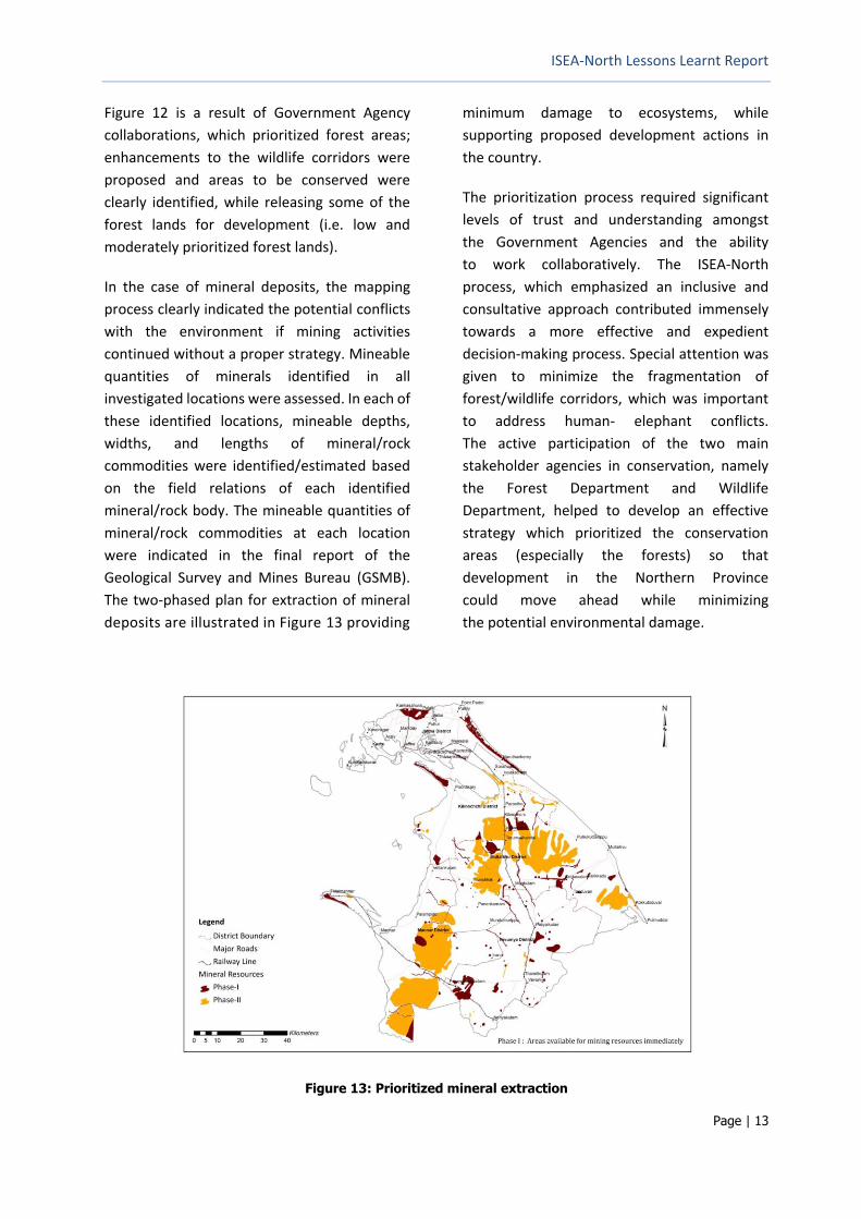
Figure 12 is a result of Government Agency
collaborations, which prioritized forest areas;
enhancements to the wildlife corridors were
proposed and areas to be conserved were
clearly identified, while releasing some of the
forest lands for development (i.e. low and
moderately prioritized forest lands).
In the case of mineral deposits, the mapping
process clearly indicated the potential conflicts
with the environment if mining activities
continued without a proper strategy. Mineable
quantities of minerals identified in all
investigated locations were assessed. In each of
these identified locations, mineable depths,
widths, and lengths of mineral/rock
commodities were identified/estimated based
on the field relations of each identified
mineral/rock body. The mineable quantities of
mineral/rock commodities at each location
were indicated in the final report of the
Geological Survey and Mines Bureau (GSMB).
The two-phased plan for extraction of mineral
deposits are illustrated in Figure 13 providing
minimum damage to ecosystems, while
supporting proposed development actions in
the country.
The prioritization process required significant
levels of trust and understanding amongst
the Government Agencies and the ability
to work collaboratively. The ISEA-North
process, which emphasized an inclusive and
consultative approach contributed immensely
towards a more effective and expedient
decision-making process. Special attention was
given to minimize the fragmentation of
forest/wildlife corridors, which was important
to address human- elephant conflicts.
The active participation of the two main
stakeholder agencies in conservation, namely
the Forest Department and Wildlife
Department, helped to develop an effective
strategy which prioritized the conservation
areas (especially the forests) so that
development in the Northern Province
could move ahead while minimizing
the potential environmental damage.
Figure 13: Prioritized mineral extraction

ISEA-North Lessons Learnt Report
Page | 14
A number of decisions were taken at these early
stages of development planning as a result of
the ISEA-North process. For example,
acknowledging the conflicts between water
availability, wildlife and the proposed urban
development for Mankulam City (to
accommodate resettlement), the UDA agreed
to reduce the size of Mankulam City and
remove one of the proposed roads, which had
the potential to disturb an important
elephant corridor (discussed further in
Section 4).
Proposed projects and the potential impacts
of the natural disasters (floods, climate
change induced sea level rise and cyclones
etc.) were factored in to the discussions
as well.
Figure 14: Disaster potentials including climate change on development projects

ISEA-North Lessons Learnt Report
Page | 15
3. Opportunity Map
The exciting and final step of the Assessment
Phase was the development of the
“Opportunity Map.” The map is a two-color
map that indicates the potential areas for
development, after considering ecological
sensitivities. To develop the Opportunity Map,
the team overlaid maps with the identified
high value areas for wildlife, forests, mineral
sites, surface water bodies and archaeological
sites, together with proposed development
projects. The remaining areas where there
were no or minimal conflicts between
environmental sensitivities and proposed
developments, were designated under the
Opportunity Map. These were essential areas
for potential development, which had reduced
or no environmental concerns.
As such, the Opportunity Map (Figure 15) is the
summary and synthesis of all of baseline and
proposed development information and
mapping outputs. It was developed to give
an easily understood and a handy reference
for policymakers and investors. The brown
areas in Figure 15 are the areas to direct
development/investment initiatives as those
areas have the minimum environmental
sensitivities and constraints including:
1. Very high prioritized wildlife areas; 2. Very high prioritized forest areas; 3. All mineral sites; 4. All surface water bodies; 5. All archaeological sites.
As the “Opportunity Map” identified areas
for development, based on more
environmentally-sustainable and risk-
informed decision-making, the map will
help in Environment approvals such as
Environmental Impact Assessments (EIAs).
Figure 15: Opportunity Map of areas with Minimum Environment Concerns

ISEA-North Lessons Learnt Report
Page | 16
Table 1: Key ISEA related statistics in the Northern Province Districts
Jaffna Kilinochchi Mullaitivu Mannar Vavuniya
Total Area (sq. km.) 1,025 1,237 2,617 2,002 1,967
Percentage Area of the Province 11.58 14.98 29.58 22.63 22.33
Surface Water (sq. km) 19.67 44 144.03 132.79 130.66
Population in 2011 ('000) 583 112 90 99 171
Urban Area (sq. km.) 63.2 133.35 829.96 9.94 22.2
Agriculture Land (sq. km) 36.29 61.61 57.57 33.33 78.00
Forest Area (sq. km) 179.91 456.08 1781.15 1336.53 1278.83
Wildlife Area (sq. km) 60.16 50.30 101.90 221.63 263.77
Very High and High Forests and Wildlife (sq. km)
218
400
1,650
1,055
897
Opportunity Area w/o Constraints (sq. km) 762.4 568.44 608.41 684.93 912.01
Percent Opportunity Area in the Districts 74.4% 46% 23% 34% 46%
Forest and Wildlife Conservation Area
218
400
1,650
1,055
897
Percent Green Area (%) without Water 21.27 32.34 63.05 52.70 45.60
Percent Water (%) 1.92 3.56 5.50 6.63 6.64
Green and Blue Conserved (%) 23.19 35.89 68.55 59.33 52.25
Percentage Area Developable with Management (%) 2.43 18.15 8.20 6.46 1.39
The percent of “opportunity areas” between
districts varied: Jaffna (74%), Kilinochchi and
Vavuniya (approximately 46% each), Mannar
(34%) and Mullaitivu (23%), indicating different
levels of intensity for potential development.
The areas identified as sensitive also could
be used for development with appropriate
safeguards. For example, there were several
conservation areas in Mannar and Mullaitivu
Districts favourable for co-management of
natural resources, green development and
ecotourism type activities.
Developments in sensitive areas require strong
environmental management (or further
environmental impact assessments) in order to
allow development investments to take
place. This also present with an opportunity
to establish improved natural resource
management and promote green development.
In these areas, carefully designed mitigation
measures based on Environment Impact
Assessments (EIAs) were recommended.
3.1. Development Scenarios
ISEA process (i.e. the proposed development
and conservation information) developed three
management/development scenarios for land
use management. They are a) Business-as-
usual; b) Conservation concerns incorporated
in development; and c) Conservation and
mitigation practices adopted in development.
The first scenario was “business-as-usual”,
which assumed that existing settlements would
be populated without much conservation
interventions.
The second scenario was developed giving
priority to environmental conservation areas
over proposed development. The proposed
conservation areas were identified based on
the environmental sensitivities established
during the baseline mapping phase.
The third scenario involved planned
development with environment management
and mitigation measures in place. Thus, the

ISEA-North Lessons Learnt Report
Page | 17
ISEA-North highlighted those areas that
required more attention based on several key
sectors.
For each development scenario, a common set
of Strategic Environmental Indicators (SEI) were
developed to represent the key sectors,
identified as important by stakeholder
agencies. Key sectors included Surface Water
(quality and quantity), Marine, Forests,
Biodiversity (Terrestrial and Marine), Cultural
aspects, Geology, Agriculture and Disaster.
After identifying the key SEIs, the type of
potential environmental issues for each
proposed development sector were ranked
according to four categories and colour coded.
1. Intervention is likely to improve the
environment as noted by the indicator
(No Colour);
2. The action may conflict with status of
Indictors (SEIs) and unlikely to be
mitigated, therefore needing special
attention (Red);
3. Potential conflict with status of SEIs and
likely to be mitigated with management
(Yellow);
4. No likely interaction with status of SEIs
(Green);
This analysis helped to better understand the
type of proposed activities (by district) that had
potential issues or needed mitigation actions.
These three levels of environmental
management were discussed among
stakeholder agencies during the ISEA-North
related agency training conducted by
Dr. Connor, UN Environment Consultant. The
training discussed development scenarios in
detail and analysed the potential impacts of the
development and resettlement process. The
potential environmental impacts, including the
disaster potentials were evaluated against
specific strategic environmental indicators, per
District. The ISEA report further analyzed the
SEIs and sector impacts.
Tables 2 to 4 provides a quick analysis on
environmental impacts of different project
ideas under different management including
business as usual and level of impacts under
conservation management. As such, the Table 4
indicates that in most locations the
development is possible with adequate
environmental management and in a number
of cases the management is not enough to
mitigate the adverse effects, therefore the
proposal needs to be significantly modified or
abandoned.

ISEA-North Lessons Learnt Report
Page | 18
Table 2: Likely effects of Business as Usual Scenario on the SEIs
SCENARIO 1: BUSINESS AS USUAL
Likely Effects on Strategic
Environmental Indicators
Wat
er S
up
ply
Wat
er Q
ual
ity
Mar
ine
Wat
er
Fore
stry
Terr
estr
ial B
iod
ive
rsit
y
Mar
ine
Bio
div
ers
ity
Cu
ltu
ral H
erit
age
Min
eral
Ass
ets
Soil
& A
gric
ult
ure
Dis
aste
r P
ron
e
FEATURES
Urban Expansion [Jaffna]
Rural Housing
Agricultural Intensification
Industrial and Commercial Intensification
Dispersed Infrastructure
Un-coordinated Mineral Extraction
LOCATIONS
Jaffna
Kilinochchi
Mannar
Vavuniya
Mullaitivu
RESOURCE REQUIREMENTS
Land
Water
Minerals
LIKELY ACTIVITIES
Dispersed Agriculture
Sea Fisheries
Rural Settlement
Urban Expansion
Large-scale Coastal Tourism Developments
Large-scale Commercial Agriculture
Large-scale Commerce and Industry
Likely to Improve
status of SEIs
Probable Conflict with status of SEIs
- unlikely to be mitigated, therefore
needing special attention
Potential Conflict with status of
SEIs - likely to be mitigated
No Likely interaction
with status of SEIs

ISEA-North Lessons Learnt Report
Page | 19
Table 3: Likely effect of Conservation Scenario
SCENARIO 2: CONSERVATION
(as envisaged by conservation agencies)
Likely Effects on Strategic
Environmental Indicators
Wat
er S
up
ply
Wat
er Q
ual
ity
Mar
ine
Wat
er
Fore
stry
Terr
estr
ial B
iod
ive
rsit
y
Mar
ine
Bio
div
ers
ity
Cu
ltu
ral H
erit
age
Min
eral
Ass
ets
Soil
& A
gric
ult
ure
Dis
aste
r P
ron
e
FEATURES
Dispersed Rural Housing
Agricultural re-settlement
Concentrated Infrastructure
Controlled Extraction
LOCATIONS
Jaffna
Kilinochchi
Mannar
Vavuniya
Mullaitivu
RESOURCE REQUIREMENTS
Land
Water
Minerals
LIKELY ACTIVITIES
Dispersed Agriculture
Sea Fisheries
Rural Settlement
Urban Expansion
Likely to Improve status
of SEIs
Probable Conflict with status of
SEIs - unlikely to be mitigated,
therefore needing special
Potential Conflict with status of
SEIs - likely to be mitigated
No Likely interaction
with status of SEIs

ISEA-North Lessons Learnt Report
Page | 20
Table 4: Likely effect of Development Scenario with Management
Scenario 3 – PLANNED DEVELOPMENT WITH
PRECAUTIONS AS ENVISIONED BY GOVERNMENT
AGENCIES
(based on the information collected)
Likely Effects on Strategic
Environmental Indicators
Wat
er S
up
ply
Wat
er Q
ual
ity
Mar
ine
Wat
er
Fore
stry
Terr
estr
ial B
iod
ive
rsit
y
Mar
ine
Bio
div
ers
ity
Cu
ltu
ral H
erit
age
Min
eral
Ass
ets
Soil
& A
gric
ult
ure
Dis
aste
r P
ron
e
MEGA CITIES
Jaffna Metro Urban City
Note: this assessment assumed that these
settlements will be developed in accordance
with subsidiary plans that are subject to SEA and
EIA (as per national regulations) and serviced by
sustainable water supplies and that effluent and
wastes will be properly treated and disposed
Poonaryn Urban City
Vellankulam Urban City
Mannar Urban City,
Kilinochchi Urban City
Mankulam Urban City
Mullaitivu Urban City
Vavuniya Urban City
FEATURES
Dispersed Rural Housing
Agricultural re-settlement
Concentrated Infrastructure
Controlled Extraction
LOCATIONS
Jaffna
Kilinochchi
Mannar
Vavuniya
Mullaitivu
RESOURCE REQUIREMENTS
Land
Water
Minerals
LIKELY ACTIVITIES
Dispersed Agriculture
Sea Fisheries
Rural Settlement
Urban Expansion
Likely to Improve
status of SEIs
Probable Conflict with status of SEIs
- unlikely to be mitigated, therefore
needing special attention
Potential Conflict with status of
SEIs - likely to be mitigated
No Likely interaction
with status of SEIs

ISEA-North Lessons Learnt Report
Page | 21
4. Specific Applications of the ISEA-North
4.1. Applications in North and Other Areas
There are a number of examples that
demonstrate how the ISEA has contributed to
strategic decision making and development
planning, covering Northern Province and
elesewhere in the country.
The National Physical Planning Department
formulated the Northern Province Regional
Structure Plan in 2012/2013 with the assistance
from the Government of Australia (AusAID)
using the ISEA information base. It contributed
to developing the infrastructure development
framework for the region for investment in the
long-run.
Another example is the Urban Development
Authority, which formulated a large number of
Urban Development Plans for Kiinochchi,
Mullaitivu, Mannar, Vavuniya, Vellankulam and
Jaffna cities. The concept plan for Mankulam
City initially included a larger environmentally
sensitive open forest area. Similarly, a forest
patch was included in the Kilinochchi Urban
development plan. Following the ISEA,
however, urban development plans were
modified to take into account the
environmentally-sensitive areas.
The Asian Development Bank (ADB) agreed to
fund the North Central Province (NCP) Canal
project, and the ISEA was used for the initial
pre-feasibility by ADB technical teams. Most of
the information contributed by government
agencies to this project was drawn from the
ISEA database.
The Forest Department had little information
on the Gazetted Forest Reserves in the
Northern Province prior to the ISEA. Based on a
special study conducted under the ISEA, the
physical boundaries of all forest areas were
identified, as these were essential for
conservation under the Forest Ordinance.
This information is now being used by the “UN
Reducing Emissions from Deforestation and
Forest Degradation (UNREDD)” initiative and
for tourism planning.
The Department of Archaeology explored close
to 260 archaeological and historically important
sites throughout the Northern Province, of
which 200 archeological sites have been
declared under a Gazette Notification.
The Department of Wildlife Conservation
(DWLC) identified the most sensitive wildlife
reserves. The dialogues facilitated by the ISEA
helped, both the Forest and Wildlife Agencies to
jointly study and establish continuous elephant
corridors in the region. As a result, DWLC
declared a number of wildlife sanctuaries in the
Northern Province mainland (Chuddikulum and
Elephant Pass) including part of the Delft Island
via Gazette Notification, 1920/3 on 22 June
2015.
The National Water Supply and Drainage Board
(NWSDB) has demarcated an area for
constructing the water impounding reservoir in
connection with Per Aru, to supply water to the
Greater Vavuniya area. The ISEA contributed in
identifying boundaries to protect water
resources. It also selected a site in Jaffna for its
sewerage treatment plant based on the ISEA.
The Lessons Learnt and Reconcilation
Commission (LLRC), which concluded its work
on 15 November 2011, recommended to
formulate District land use plans for the five
districts of the Northern Province in order to
facilitate the monitoring process of establishing
humanitarian needs in the North. The Land Use

ISEA-North Lessons Learnt Report
Page | 22
Policy Planning Division of the Ministry of Lands
use the ISEA data extensively as well.
The ISEA North specifically investigated the
most attractive, potential areas for tourism in
the Northern Province including land and
marine based resources for development.
The Sri Lanka Tourism Development
Corporation recognised areas identified by the
ISEA as suitable to promote tourist hotels, guest
houses and other resorts. Tourism plans are
being developed for Mannar (with support from
The World Bank/International Finance
Corporation), and Delft Island (by the Land Use
Policy Planning Department).
Based on ISEA information, the International
Union for Conservation of Nature (IUCN), the
UDA, Tourist Board and Coast Conservation
Department carried out field assessments
covering 24 islands in the Gulf of Mannar and
Palk Bay area in the Northern Province.
The information generated will help to
implement Development Scenario 3 identified
by the ISEA-North process, including the
generation of information for undertaking EIAs
for specific projects in this area.
The Governments of India and Sri Lanka held a
series of discussions on the post-conflict fishing
discords in the Palk Bay and Gulf of Mannar.
The discussions benefitted from the ISEA-North
environmental baseline information on the
location of seagrass meadows and other
sensitive marine areas. Discussions held
in November 2016 recommended the
acceleration of joint work to develop
conservation and management plans for
fisheries in order to address illegal and
ecologically damaging fishing practices.
The ISEA-North information could be of
immense help to decide on alternative
livelihoods for Sri Lankan fishermen.
UDA and the Department of Archeology
developed the “Heritage Tourism Development
Plan for Delft Island”, which it submitted to the
Department of National Planning for funding,
using the ISEA-North generated information.
The World Bank funded the Environmental
Assessment and Management Framework of
the Strategic Cities Development Project
(SCDP) of the Ministry of Megapolis and
Western Development (2016), which used the
ISEA-North Opportunity Map and other
information in peparation of the Integrated
Drainage Master Plan for the Jaffna Municipal
Council area including ponds.
The process of using SEIs and scenario-based
evaluation was adopted in the SEA for the
“Western Region Megapolis Planning” (WRMP)
in May 2016. The WRMP is the Government’s
largest urban development project
(http://wrmpp.gov.lk/).
In 2016, the Japan International Cooperation
Agency (JICA) decided to use an SEA approach
based on the ISEA-North experience to
generate an integrated development plan for
the Kandy City, the second largest city in
Sri Lanka. Kandy and its suburbs have a range of
environmental issues related to transport,
connectivity, settlement, disaster risk, and
pollution issues linked to rapid development.
As the last capital governed by Sri Lankan Kings
and as the country’s Buddhist center,
Kandy holds an important historical and cultural
signficiance.
4.2. Use of ISEA outside Sri Lanka
Based on Sri Lanka’s ISEA experience, UNEP
proposed to use the ISEA approach as one of
the multi-sector and multi-stakeholder tools for
post-conflict and post-disaster development
support. UNEP funded a knowledge transfer
activity among three countries; namely, Cote
d’Ivoire (a country in the African continent,
emerging after a conflict) and Nepal (a country
that is in the process of rebuilding after the

ISEA-North Lessons Learnt Report
Page | 23
2015 earthquake) and Sri Lanka (a country that
already has ISEA experience).
Between March 20-23, 2017 delegates from
Nepal and Cote d’Ivoire with UNEP staff
attended the knowledge sharing workshop in
Colombo where key agencies from Sri Lanka
involved in ISEA-North shared their experience.
The delegation then visited the Northern
Province for three days and met Government
officials, NGOs and also visited key sites
described in the ISEA-North as Conservation
Areas. These areas include the Chundikulam
Sanctuary in the Kilinochchi District and
the Vankalai Wetland and Bird Sanctuary
located in the Mannar District. During the
tour to Northern Province, the visitors met
with Northern Provincial Council key officials
at Jaffna in a meeting chaired by the
Hon. Minister of Environment. The Minister
pointed out that during the war, forest reserves
were safe with a forest cover reaching up to
54% and how post-conflict development cause
pressure on natural resources, including
forests, geological resources and water. He
highlighted the importance of the ISEA
approach and the process as a potential tool for
sustainable natural resource management and
also highlighted the need to declare ISEA as a
legal document.
As a result of the knowledge sharing workshop,
Nepal with an estimated loss of US$ 700Bn to
the economy due to the 2015 earthquake, plans
to identify opportunity areas to locate 600
identified projects and livelihood development
programmes as part of the reconstruction
process. Nepal selected their Road Sector
project as the sector to test the ISEA approach
as a pilot. During the discussion, the Nepal team
identified two major barriers; namely, the
authentication of available data and assessing
concerned agencies to adopt the ISEA
approach. Nepal also highlighted the need to
include habitat types; recognize the influence of
rebuilding the National Parks and Wildlife to
ensure sustainability; need to adopt soil and
eco system values of forests in the process;
Figure 16: Team Leader ISEA-North, Prof. Buddhi
Marambe on Sri Lanka experience
Figure 18: Nepal, Cote d'Ivore and UNEP team meeting
Northern Provincial Minister of Environment
Figure 17: Team Nepal plans to adopt ISEA experience in
post-earthquake reconstruction
ISEA-North Lessons Learnt Report
Page | 24
need for incorporating Earthquake Maps for
hazard and vulnerability assessments; and
including geology, soil, water drainage, land
use/land cover to strengthen plans and decision
making.
Similarly, the team from Cote d’Ivoire identified
the major project that involve a Port Expansion
as the subject to apply the ISEA process. The
team identified several barriers: namely, the
difficulty in getting required data/lack of data;
need for a mechanism and strategy to collect
unavailable data; and lack of expertise in the
ISEA process.
During the deliberations, the team highlighted
the need to understand the influencing factors
of the Port project; value of identifying the
designs to minimize erosion towards east using
hydrological modeling when constructing two
breakwaters; necessity to identify highly
affected areas and moderately affected areas
using climate change impact data.
Figure 19: Examining the potential multi-
stakeholder approaches to port St. Pedro project

ISEA-North Lessons Learnt Report
Page | 25
5. Lessons from the ISEA Process
5.1. Agency Co-operation
The approach taken by the ISEA process
was to say “yes” to development and
reconstruction in the Northern Province, while
highlighting environmentally-sensitive areas
for conservation or for further assessment.
Maps generated have been used by National
government agencies and helped to inform
the Uthuru Wasanthaya (Northern Spring)
development programme.
The ISEA-North process created a single
platform that increased the confidence
and comfort levels of the Government
Agencies to make decisions collectively and
through consensual dialogue. The enabling
environment created by the ISEA process
helped to overcome institutional barriers and
enhanced information-sharing amongst
Agencies and the Provincial and District
Governments. A single database was
established within the UDA, which was shared
between all participating government agencies.
Trust-building was established by developing
initial factsheets, which explained the meaning
and objectives of the proposed ISEA work.
Lead agencies, namely the CEA, DMC and UDA,
convinced the other agencies of the value of
being part of the ISEA.
The participation of the CEA as the lead partner,
in particular, was important. As the CEA is the
main Government approving authority for
Environmental Compliance, their involvement
was critical to the ISEA process.
UNDP played an active role in supporting
Government agencies in all the steps of ISEA-
North. Briefings to senior officials in then
Government, both at National and Regional
levels were a key aspect of the project.
5.2. Political Authority Support
The work of Government Agencies received
political support and endorsement from the
highest levels, particularly the Presidential Task
Force, which allowed field access to the
Northern Province. The trust, which had been
built between the Government Agencies, the
PTF and UN was critical in supporting the
process to move forward.
5.3. International Inputs
Inviting senior technical staff through UNEP to
support the design of the ISEA was
advantageous and added value to the ISEA
Process. Sector experts working with
Government officers from different Agencies,
even with limited data, made it feasible to
discuss the possible outcomes of proposed
developments, undertake the assessments and
adjust plans accordingly.
5.4. Baseline Information Generation
The ISEA helped to generate and fill information
gaps on essential data such as forests, geology,
archeology, soils, water, etc. However, this
effort of generating new information added
a minimum of one year to the ISEA process.
This involved identifying information gaps;
having adequate resources to generate the
information; agencies willingness to work in
hazardous and dangerous conditions, after the
conflict, in the field; and waiting for new
information before stakeholder dialogues could
be conducted.
Nonetheless, baseline mapping and
information gathering contributed immensely
to the process, because it established a sound
basis for making and prioritizing land-use
decisions. In order to replicate the ISEAs in post-

ISEA-North Lessons Learnt Report
Page | 26
conflict/disaster situations, this additional time
investment for data gathering needs to be
factored into timelines and resources.
Furthermore, mobilizing senior technical
experts from within and outside Government
Agencies also proved equally critical.
For example, the Archeological Department
identified over 200 new sites mostly in the
Mullaitivu area in the proximity to the final
battle ground of the Sri Lanka Army and
rebel/opposition fighters, with support of
Archeological experts outside the Department.
Similarly, other Agencies also used top-notch
talents to map natural resources and other
information.
5.5. Environment for Decision-Making
Before the ISEA, the standard practice was that
each sector (and corresponding Government
Agency) would independently decide on
land-use for that given sector with no or little
consultation with other sectors, thus increasing
the chances of creating conflicting
development and environmental priorities.
Proposed infrastructure plans often
contradicted the conservation plans of forests,
wildlife, water resources, and archeological
sites. Moreover, in most cases, disaster and
climate risk considerations were not part of
proposed development plans. The ISEA
changed these standard practices.
For example, the pooling of information and
collective analysis, with regards to resettlement
planning, disaster information, forestry, wildlife
and minerals, helped government agencies to
better understand each other’s priorities and
views on where they could compromise and
reach practical solutions. One such instance
was the “historical” agreement, on how to
prioritize forested areas in the Northern
Province, allowing certain areas to be released
for resettlement and development, which had
the critical endorsement from the Forest
Department. Similarly, government agencies
reached consensus on maintaining a high level
of conservation in some areas in order to
maintain wildlife corridors and protect
archaeological areas from infrastructure
construction, mining and other developments.
Potential environmental conflicts of proposed
development actions were identified at early
stages and before development actions
could be implemented, thus minimizing
environmental impacts and risks.
For example, the resettlement process in the
North was informed primarily by the new
development plans generated after the ISEA by
the UDA and other investment agencies for
developing tele-communications, roads, ports,
power, irrigation etc. The ISEA-North process
helped validate the proposed resettlement
areas and avoided resettlements in disaster-
prone areas or environmentally-sensitive areas
(i.e. avoiding human-elephant conflicts by
settling near elephant corridors). The ISEA
process enabled agencies to compare
settlements prior to 1983 (before the conflict),
and move these away from identified disaster-
prone areas (cyclone paths, flood-prone areas,
etc.) and from environmentally-sensitive areas.
Even the size and location of a city like
Mankulam was changed based on the ISEA
process and information, as discussed in
Section 2.
The ISEA-North process introduced the use of
Strategic Environment Objectives (SEOs) and
development scenario assessment (Table 2, 3
and 4), which were novel to many of the
Government agencies involved. The scenario
assessment allowed agencies to better
understand potential environmental issues on
the ground from a high-level perspective (i.e.
obtaining an overall picture) and discuss
remedial measures. These remedial measures

ISEA-North Lessons Learnt Report
Page | 27
were compiled in the Final ISEA-North Report.
In this regard, the ISEA -North paved the way for
a meaningful assessment before development
activities progressed, while at the same time
addressing post-conflict reconstruction and
development needs.
5.6. Support to Development Partners
International donors found the ISEA outputs
useful since they were generated as a collective
effort by multiple Government Agencies.
For example, the North Central Province Canal
project, funded by the Asian Development
Bank, as mentioned previously, used the ISEA
results for conducting its due diligence process;
this project provided water to the North
through river diversions from the South, and
facilitated water supply schemes for the Jaffna
Peninsula.
The ISEA process contributed directly to early
post-conflict normalization in terms of access to
livelihoods, markets and improved quality of
life in the Northern Province. However, the
healing and re-integration aspects of the
normalization process will take time, and the
ISEA-North considerations of sustainability will
contribute towards this long-term process,
thereby providing support to multiple
development efforts.
5.7. Logistics and safety
Throughout the ISEA-North, special attention
was given to ensure the safety of staff. Travel
timing and working in mine cleared areas were
the main concerns. Following UN travel
guidelines and obtaining the support of
Sri Lanka Military helped much towards safety
and security of the teams engaged in field level
studies. This aspect was particularly important
in commissioning and conducting studies, after
post-conflict situations where land mines are
around. Some of the land mines over the years
may have washed away from original site,
creating hazardous conditions beyond
identified mapping areas.

ISEA-North Lessons Learnt Report
Page | 28
6. Lessons from ISEA Implementation: Five Years After
6.1. Slow Adoption of ISEA
ISEA-North was an innovative process that
was introduced and implemented at the
most appropriate time, just before the
development wave reached the Northern
Province. ISEA planning started in November
2009 and ended with the Final ISEA Report in
2014. Nevertheless, the information generation
was completed in 2011 and inter-agency
discussions were completed in 2012, with most
of the recommendations available to agencies
by the end of 2012.
However, the potential use of the information
generated from the ISEA-North, in terms of
implementation of the ISEA recommendations
found in the Final Report, has not yet been fully
realized nor mainstreamed in the development
of the Northern Region, even five years later.
On one hand, information collected during the
studies conducted by the key government
agencies, funded by UNDP, as inputs to the
ISEA-North (Geology, Water Resources,
Archeology, Marine and Coastal etc.), was
immediately mainstreamed through their line
functions and used to prepare budget proposals
for coming years etc. Many agencies have been
extensively using the maps generated through
the ISEA process, including the baseline maps
and maps with combined overlays.
A review process carried out by IUCN, five years
later identified the main reasons for the
lack of mainstreaming and follow-up to
implementation.
ISEA-North process assumed that the lead
agencies, especially the CEA and DMC, would
take ownership and mainstream the ISEA data
and recommendations through National and
Regional development plans. This assumption,
did not materialize, fully or as expected,
primarily since the ISEA-North
recommendations were not formalized as a
legal instrument. In Sri Lanka CEA has the
national mandate for conducting SEAs and
monitoring compliance.
The Disaster Impact Assessment idea put
forward by the Disaster Management Centre
also did not achieve the expected level of
mainstreaming.
If the legal status of the ISEA-North had been
established, the adoption of the ISEA
recommendations and follow-up monitoring
would have been greater. For example, the
regional CEA office based in Jaffna would
have had a legal mandate to push for the
implementation of recommended levels of
natural resources use in certain areas.
The actual practice or level of mining of sand
and gravel was much higher than the permitted
level of mining that was approved by the
Geological Services and Mines Bureau (GSMB),
a critical deviation from the ISEA-North
prescribed level.
6.2. Extent of International Assistance
Another aspect worth observing is the extent of
donor involvement in the development and
implementation of the ISEA. During the
development of the ISEA process, UNDP took a
major responsibility in conceptualizing,
fund raising, providing technical support,
coordinating and facilitating the process, while
CEA and DMC provided the necessary and
critical legal and institutional mandate.
The speed and the quality of ISEA-North
development was largely attributed to the
involvement of international development

ISEA-North Lessons Learnt Report
Page | 29
partners, the leadership provided by the CEA
and DMC, and the commitment of participating
agencies.
However, the same combination and levels
of engagement could not be realistically
expected during the implementation of the
ISEA recommendations and findings. Most of
the implementation issues have been
attributed to the lack of political leadership and
the inability of Government offices to push
forward the ISEA-North recommendations,
partly due to lack of capacity, but mostly due to
the lack of political will.
On the other hand, it can be questioned that
the ISEA process was not Government driven
although the Government participated in each
of the steps. This may have impacted the
adoption of ISEA recommendations and poor
buy in by the Government. Although there is no
clear answer to this aspect, but it is good to pay
attention to this “ownership” element in future
work, especially in programmes that involve
extensive international assistance.
6.3. Political Will for Implementation
It is very interesting to note how the level of
political will changed during the time
ISEA-North progressed. The Chairman and the
members of the Presidential Task Force
(PTF) for Northern Development “Uthuru
Wasanthaya – Northern Spring” fully endorsed
and supported the ISEA process. The Chairman
(also the then Hon. Minister of Economic
Development) ceremonially inaugurated
the ISEA-North’s “Map Compendium” at
Colombo Hilton. The event was attended by the
Hon. Minister of Economic Development, Hon.
Minister of Environment, Secretary of the
Ministry of Environment, Chairman of Central
Environment Authority and Director General of
the Disaster Management Centre, Country
Director of UNDP, and other invited
representatives from local and international
agencies.
The review indicated that the information
on potential benefits and the long-term
value of implementing the ISEA-North’s
recommendations was not effectively conveyed
to high-level policymakers, including the
Chairman of the Presidential Task Force for the
North, at the time when the Opportunity Map
was launched. Hence, future efforts need to
invest heavily on communication and advocacy.
6.4. Advocacy Needs
Despite the enthusiasm and support generated
in launching maps and studies, the ISEA-North
was not totally embraced by the Ministry
of Economic Development. The ISEA-North
process was sometimes considered as a
restriction to accelerated development.
Findings indicated that the political authorities
considered that the Opportunity Map restricted
the freedom to make decisions for identifying
areas for development. For example, the
announcement of Chundikulam and Delft as
sanctuaries was put on hold, and they were
gazetted after the Government change in 2015.
One possible scenario to explain why a less-
than-ideal political acceptance was received
may be attributed to the way in which the
Figure 20: Inauguration ceremony of
ISEA-North

ISEA-North Lessons Learnt Report
Page | 30
Opportunity Map was presented to
policymakers. Although the areas for
development without constraints were
significant, with over 70% in the Jaffna District
and around 46% in Kilinochchi and Vauvniya,
this proportion may have still been considered
too restrictive for major proposed
developments.
On the other hand, in other districts where
technical capacities to enforce proper
environmental management were more
available, areas for development could be
further expanded, as per the ISEA-North
information (Table 1). Information could have
been presented in a manner which more
clearly explained the different options to
policymakers.
6.5. Traditional vs. prescribed land uses
Although the ISEA-North recommended certain
land-use options, it did not discuss
the mechanisms to free up identified
environmentally-sensitive areas that had once
been used as settlements in the past. It also
did not discuss ways for compensating
population displacements, which might
result from implementing the ISEA-North
recommendations, e.g. to create elephant
corridors.
Enhanced corridors for wildlife and high
value forest conservation areas sometimes
contradicted the concept of the “right to
resettle” by former residents in areas that were
identified as environmentally-sensitive in the
ISEA-North findings. This aspect created several
land-use conflicts, especially in Vavuniya and
Mannar Districts, where former residents
stressed the need to return to their original
settlements.
Government had to appoint a Special
Committee to resolve the land conflicts
associated with human rights and conservation
needs. However, one may argue that
addressing all socio-economic issues is not the
primary objective of the ISEA and that follow-up
actions may be warranted in this regard, but
falls outside the scope of the ISEA process.
6.6. District Level Experience
During the review in 2016 conducted by IUCN,
discussions with key government agencies,
district administrative authorities and planning
units in the five Northern Province Districts
revealed several important considerations
towards implementing recommendations.
Introduction of the SEOs and Scenario
Assessments followed by recommendations for
each development project had been the core of
the ISEA-North implementation at district level.
District Government staff confirmed that the
ISEA related information was useful and
recommendations are being implemented, but
at a less than optimal speed.
The review indicated that it was not too late to
revisit ISEA recommendations and carry out
extensive awareness, education and capacity-
building efforts at National, Provincial and
District levels, in order to reach the expected
benefits of ISEA, making development
sustainable and resilient.
The following points were made based on
discussions in the Districts, conducted in 2016:
a. The Provincial Ministry of Environment
and Agriculture has taken steps to
promote the ISEA-North approach.
However, there remains a
disconnection between the National,
Provincial, District and Local Authorities
in terms of sharing information and
joint planning, implementation and

ISEA-North Lessons Learnt Report
Page | 31
monitoring, including for the ongoing
Sustainable Development Goals (SDGs)
process.
b. With the exception of the Jaffna
District, the four other districts have
not used the ISEA-North data as a basis
for undertaking subsequent planning
after 2011. Change in staff, lack of
computers and GIS capacity and
inability to see the usefulness of the
ISEA were some of the identified
barriers to ISEA uptake. However, as a
result of the review in 2016, districts
have improved their understanding and
appreciation of the ISEA data. They
have requested for update of the ISEA
data and support for capacity-building
to use the information in planning,
implementation and monitoring.
c. It was envisaged that the UDA will act
as the clearing house for ISEA-North
information. The process was delayed
due to issues related to National Data
Clearing Mechanism establishment,
that is ongoing. However, the ISEA-
North data was made available via
multiple channels and there is room
for improvement in the data exchange
processes. This was identified as a
barrier to mainstream ISEA into
regional, district and local authority
plans, and to bring the planning
processes in the Northern Province to
a single platform.
d. As part of the ISEA-North, the project
trained the District Planning Units in all
five Northern Province Districts on the
use of ISEA data at the University
of Peradeniya for three weeks.
An external GIS expert was seconded
for six months to the District Planning
Units to ensure that the GIS systems
were in place and that ISEA data/maps
are being used. Although the ISEA data
was transferred and capacity of staff
was improved in the District Planning
Units, mainstreaming of ISEA data in
district level planning and development
were less than optimal.
e. More investment and time was needed
to ensure mainstreaming of the ISEA
findings. The assumption was that the
Government Agencies would take the
ISEA findings forward, yet this was not
achieved. Given that that Provincial
staff have many priorities, uptake
of the ISEA findings had proved
challenging.
f. ISEA-North created a mechanism for
briefing new senior Government staff in
the districts. As the Government staff
turnover is high, especially in the
North, the project at least ensured
a mechanism to update new
Government officials, including senior
politicians.
Although the CEA and DMC led the ISEA-North
Process, the training and capacity building after
the completion of ISEA-North was carried out,
primarily through DMC due to resource
limitations at CEA (funding and human).
DMC had Disaster Management Coordinators in
all five districts, whereas the CEA operated only
in the Jaffna District.
District Planning Units were the key target
group in the five districts where the training, in
terms of map use, was directed. However, both
CEA and DMC did not use the ISEA-North as a
key tool for their long-term strategic planning
and follow up on the implementation of ISEA
recommendations. This could be attributed to
the fact that the ISEA-North process fell short
of legalizing the recommendations, thereby

ISEA-North Lessons Learnt Report
Page | 32
creating an environment where agencies are
bound to use the content.
With the momentum of the ISEA-North, similar
processes were initiated in the Uva Province
and Gampaha District, but showed only partial
completion. Data compilation was undertaken,
but the CEA did not want to pursue it
intensively, primarily because of staff changes
and changes in Government in the respective
districts.
Awareness-raising amongst other stakeholders,
namely district government agencies, non-
government entities and communities, is key
to a successful ISEA development process.
However, the ISEA-North process did not
allocate additional resources, nor did UNDP
have resources to continue awareness-raising
beyond the work carried out during the
ISEA-North. Some efforts were carried out by
the Northern Province Ministry of Environment
in local awareness-raising, under the leadership
of the Hon. Minister. Nonetheless, there are still
opportunities to pick up the momentum in
order to deliver extensive awareness-raising
and education support to help operationalize
the ISEA-North.
Reservoirs made by ancient rulers (tanks)
located within proposed forest protected areas
was another concern raised. Some of the
tanks have been associated with previous
settlements and were abandoned due to the
conflict. A number of decisions are needed in
the future land-use related to these tanks if the
areas are to be identified as “no-development”
zones. Several options to manage such
situations are available, e.g. using principles of
co-management, Payments for Ecosystem
Services (PES) and benefit sharing among
agencies and forest communities.
Addressing climate concerns has been a
forgotten priority in the Northern Province’s
development. Observed practices in the
Province include extensive ground water
pumping in Jaffna, Mannar and Vavuniya
Districts. Government Agencies have provided
agriculture pumps for farmers as part of the
resettlement process without adequate
education on groundwater re-charge and basic
elements of the hydro-geological cycle and
need for water resource management.
Yet, water scarcity is a major development
constraint in the Northern Province, as
identified in the ISEA, and which will likely
worsen as a result of climate change impacts.
Jaffna is already showing signs of sea water
intrusion into ground water, partly as a result of
over-abstraction. Eventually, accelerated sea
level rise due to climate change will further
exacerbate sea water intrusion. The ISEA-North
identified climate related potential impacts,
which could be addressed with better
awareness and climate-smart technologies and
development investments, including for
livelihoods.
ISEA-North Lessons Learnt Report
Page | 33
7. Conclusions
7.1. Key Observations
The ISEA-North process demonstrated a sound
approach to post-conflict development and
reconstruction, based on a multi-stakeholder
planning framework. The key steps adopted
in the ISEA-North—compiling available
information, generating new information,
engaging stakeholders, resolving land-use
conflicts—could be a general approach, which
can be applied in post-crisis situations.
Additional time to address data gaps should be
factored, in cases where baseline data are not
readily available. Obtaining new information
often outweighs the disadvantages caused by
delays due to additional data collection and are
worth the wait. In addition, information
generated strengthens the government
agencies’ capacities to fulfill their functions,
a further benefit from this extra investment.
The main weaknesses identified included:
a. the lack of strong advocacy to obtain
national and regional level political
ownership to ensure follow-up
implementation of the ISEA-North
recommendations; and
b. the inability to legalize the
recommendations, which would have
empowered regulatory agencies to
monitor the development activities
in line with the broader
recommendations of the ISEA-North.
Agencies at the district level requested for
updated ISEA-North information and capacity-
building support. Hence, there appears to be
continued interest from the local government
to revitalize the ISEA implementation process.
Still the new and ongoing projects and designs
can be made environmentally sound and
disaster and climate resilient, by using the
ISEA-North material and the process. Maps and
other information of the ISEA-North provide a
sound base for monitoring by the District
Advisory Committees, where District planning
units provide the secretariat support.
The approaches used in the ISEA-North are
generic and can be adapted to other SEA
processes that involve more data and
stakeholder groups. This was clearly
demonstrated by other Sri Lanka projects, such
as the Sustainable Cities Project by the World
Bank for Jaffna and Kandy and the SEA for
Western Region Megapolis Planning, which
have adopted elements of the ISEA-North
process.
7.2. Way Forward
Policymakers can use the ISEA-North process to
channel large investments such as industries
with potential impacts on the environment
towards the designated “opportunity areas”,
whilst promoting other areas for nature-based
development, such as ecotourism and other
green development activities. This aspect of the
ISEA-North implementation requires more
specific guidance, so that potential land use is
matched with the appropriate environmental
management and intensive monitoring of
potential impacts on the environment.
This requires strong political will and
enforceable mandates to make the Northern
Province development sustainable and
resilient.
The information generated during the
ISEA-North is still relevant for management of
ecosystems and natural resource use in the
Province. Hence, it is not too late to look at

ISEA-North Lessons Learnt Report
Page | 34
ways of mainstreaming the ISEA data,
recommendations etc. in the Northern Province
development. Several steps can be proposed as
a way forward to maximize the benefit of
ISEA-North.
a. Both Central Government and Provincial
Governments accept ISEA-North as the
guidance document for planned
development and use of natural resources.
b. Identify and invest on capacity development
of planners and staff to use ISEA
recommendations, including maps, data,
proposed safe-guards on natural resources.
c. Update the ISEA-North data set on land use
and proposed projects, and engage the
stakeholder entities again in a discussion
process to renew the interest on the process
and update the decisions on priority land
uses including the “Opportunity Map.”
d. Provide the legal powers necessary to
incorporate the ISEA-NORTH in the
development planning and environment
conservation related decision making,
including the CEA and other Agency
approvals for resource use.
e. Create a communication strategy and
educate and create awareness among
stakeholder entities including public on the
value of planned development to improve
sustainability and resilience of people and
ecosystems. Several studies to quantify the
gains by doing so and what if scenarios on
different resource uses could help much.
f. Setup and maintain a relevant and strong
monitoring system to help the Provincial and
District planning on the changes to natural
resources and any potential adverse impacts
to ecosystems and resilience.
These steps can be again taken jointly by the
Government, UN and other relevant agencies.
8. References
ISEA-North Map Atlas. 2014. https://goo.gl/YcwFbq
Integrated Strategic Environmental Assessment of the Northern Province of Sri Lanka, Final Report.
2014. https://goo.gl/kJRV5N
OECD. 2006. Applying Strategic Environmental Assessment – Good Practice Guidance for Development
Cooperation. 160 pp. Organization for Economic Cooperation and Development, France.

Recommended