Kb
Kb
Kb
Qe
Qe Qe
Qe
Qe
Qe
Qe
Qe
Qe
Qe
Qe
Qe
Qe
Qe
Qe
Qe
Qe
Qe
Qal
Qal
Qap?
Qap?
Qap?
Qap?
Qap?
Qap?
Qap?
Ktmu
Ktmu
Ktmu
Ktmu
Ktmu
Ktmu
Ktmu
Ktmu
Ktmu
KtmuKtmu
Ktmu
Ktmu
Ktmu
Ktmu
Ktml
Ktml
Ktml
Ktml
Ktml
Ktml
Ktml
Ktml
Ktml
Ktml
Kmmu
Kmmu
Kmmu
Kmmu
Kmmu
Kmmu
Kmmu
KmmuKmmuKmmu
Kmmu
Kmmu
Kmmu
Kmmu
Kmmu
Kmml
Kmml
Kmml
Kmml
Kmus
Kmus
Kmus
Kmus
Kmus
Kmus
Kmus
Kmus
Kmus
Kmc
Kmc
Kmc
Kmcu
Kmcu
Kmcs
Kmcs
Kmls
Kmls
Kmls
Kmls
Kmls
Kmls
Kmls
Kmls
Kmls
Kmls
Kmls
Kbgu
Kbgu
Kbgu
Kbgu
Kbgu
Kbgl
Kbgl
Kbgl
Kmc
Kmc
Kmc
Kmcu
Kmcs
Kmc
Kmc
Kmc
Kmc
Kmc
Kmc
Kmc
Kmus
Kmus
Kbgl
Kbgl
Ktmu
2
8
2
2
5
1
1
2
4
1
Kbgu
Kmls
Kmcs
Kmc
Kmus
Kmus
Kmc
Qap?
Qap?
Qap?
Ktml
5900
6000
6100
Kmcu
Kmc
530
0
5300
5400
5400
B
A
A'
B'
Ktml
Kmmu
KmmuKtml
Ktml
Kb
Kmcu
Kmcl
5500
5500
Kmc
Kmc
Kmc
Kmc
Kmc
Kmus
Ktmu
5700
5700
5600
560
0
Kb
Kb
Kb
Kmls
590
0
5800
5800
Kmls
Kmls
Kbgu
Kbgu
Kbgl
Kbgl
Kbgu
Kbgu
Kbgu
Kbgu
Kbgu
Kbgu
Kmml
Kmml
Kmml
Kmmu
Kmmu
Ktmu
Ktmu
Ktml
Ktml
Ktml
Ktml
Ktml
Ktml
Kmus
Kmus
Kmus
Kmus
Kmml
Kmml
Kmus
Kmcu
Kmcu
Kmcs
Kmcs
Kmcu
Kmcu
Kmus
Kmus
Kmus
Kmus
Kmls
Kmc
Kmc
Kmls
Kmls
Kmc
Kmc
Kmls
Kmls
Kmus
Kmus
Kmc
Kmc
Kmc
Kmus
Kmls
Kmls
Kmls
Kmc
Ktml
Ktml
Ktmu
Ktmu
Kmcl
Kmus
Kmus
Kmcs
KmcsKmcl
Kmcl
Kmcs
Kmcs
Kmcu
Kmcu
Kmcl
Kmcl
Kmcs
Kmcs
Kmcl
Kmus
Kmus
Kmcl
KmcuKmcs
Kmcs
Kmcu
Kmcl
Kmcl
Syncline
Mountains
Henry
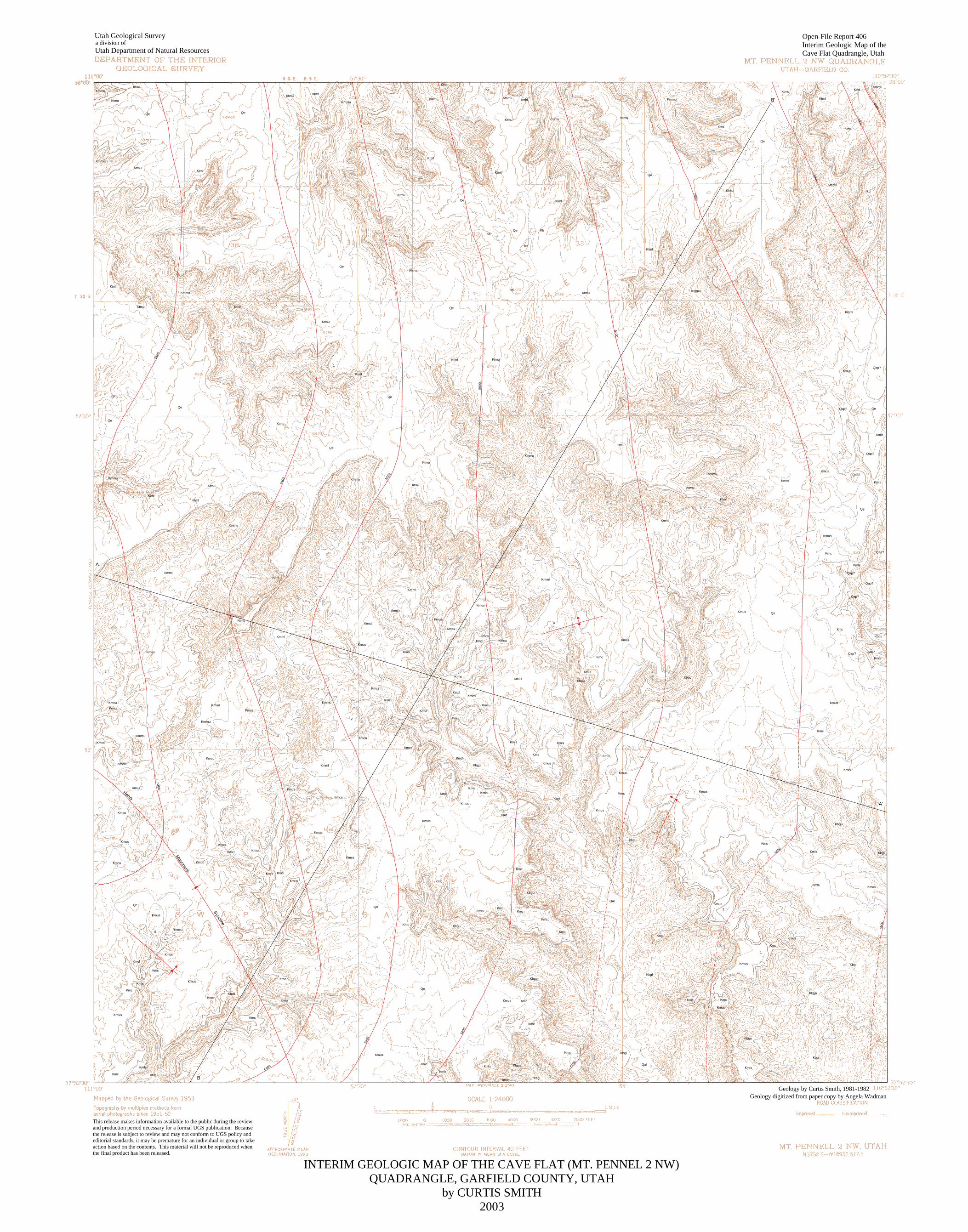
Utah Geological Survey
Utah Department of Natural Resourcesa division of
Open-File Report 406Interim Geologic Map of theCave Flat Quadrangle, Utah
Geology digitized from paper copy by Angela Wadman
This release makes information available to the public during the reviewand production period necessary for a formal UGS publication. Becausethe release is subject to review and may not conform to UGS policy andeditorial standards, it may be premature for an individual or group to takeaction based on the contents. This material will not be reproduced whenthe final product has been released.
INTERIM GEOLOGIC MAP OF THE CAVE FLAT (MT. PENNEL 2 NW)QUADRANGLE, GARFIELD COUNTY, UTAH
by CURTIS SMITH2003
Geology by Curtis Smith, 1981-1982

AA'
B
B'
Swap Canyon Swap Mesa
Tarantula Mesa
Muley Canyon Cave Flat
Kmm
Kmmc
Kmbg
Kmf
KmtKd
Je
Jca
Jn
Kmmc
Kmbg
Kmf
KmtKd
Je
Jca
Jn
Kmmc
Kmbg
Kmf
Kmt Kd
Je
Jca
Jn
Ktm
Kmm
Kmmc
Kmbg
Kmf
KmtKd
Je
Jca
Jn
Sea LevelSea Level
Sea Level Sea Level
Ktm
Ktm
2,000
4,000
FEET
FEET
FEET
FEET
6,000
4,000
2,000
6,000
4,000
2,000
2,000
4,000
6,000
TRm
TRm
TRmTRm
Cross sections are diagrammatic
Cross sections are diagrammatic
KJcm
KJcm
KJcm
KJcm
Jsc
Jsc
Jsc
Jsc
Jk
Jk
JkJk
Jw
Jw
JwJw
TRc
TRc
TRcTRc
Open-File Report 406Interim Geologic Map of theCave Flat Quadrangle, Utah
INTERIM GEOLOGIC MAP OF THE CAVE FLAT (MT. PENNEL 2 NW)QUADRANGLE, GARFIELD COUNTY, UTAH
by CURTIS SMITH2003

INTERIM GEOLOGIC MAP OF THE CAVE FLAT (MT. PENNELL 2 NW) QUADRANGLE,GARFIELD COUNTY, UTAH
Curtis Smith
This open-file release makes information available to the public during the review andproduction period necessary for a formal UGS publication. Because the release is subject toreview and may not conform to UGS policy and editorial standards, it may be premature for anindividual or group to take action based on the contents. This material will not be reproducedwhen the final product has been released.
OPEN-FILE REPORT 406 March 2003 UTAH GEOLOGICAL SURVEY a division of UTAH DEPARTMENT OF NATURAL RESOURCES
IHS Energy5333 Westheimer
Houston, TX 77056

MAP AND CROSS-SECTION UNITSCave Flat (Mt. Pennell 2 NW) 7.5' quadrangle, Garfield County, Utah
Quaternary DepositsQe Windblown sand and loess
Qal Stream alluvium
Qap? Pediment-mantle(?) gravel
Cretaceous RocksKb Beds on Tarantula Mesa (Kaiparowits? Formation)
Ktmu Upper part Tarantula Mesa Sandstone (Ktm-2 of Smith, 1983)
Ktml Lower part Tarantula Mesa Sandstone (Ktm-1 of Smith, 1983)
Kmmu Upper part Masuk Shale Member of Mancos Shale (Kmm-2 of Smith, 1983)
Kmml Lower part Masuk Shale Member of Mancos Shale (Kmm-1 of Smith, 1983)
Kmus Upper fluvial sandstone of Muley Canyon Sandstone Member of Mancos Shale(Kmmc-3 of Smith, 1983)
Kmc Coal interval of Muley Canyon Sandstone Member of Mancos Shale (Kmmc-2 ofSmith, 1983)
Kmcu Upper coal interval of Muley Canyon Sandstone Member of Mancos Shale (Kmmc-2cof Smith, 1983)
Kmcs Sandstone of coal interval of Muley Canyon Sandstone Member of Mancos Shale(Kmmc-2b of Smith, 1983)
Kmcl Lower coal interval of Muley Canyon Sandstone Member of Mancos Shale (Kmmc-2a of Smith, 1983)
Kmls Lower massive sandstone of Muley Canyon Sandstone Member of Mancos Shale(Kmmc-1 of Smith, 1983)
Kbgu Upper part Bluegate Shale Member of Mancos Shale (Kmbg-2 of Smith, 1983)
Kbgl Lower part Bluegate Shale Member of Mancos Shale (Kmbg-1 of Smith, 1983)
Cretaceous Rocks on Cross SectionsKtm Tarantula Mesa Sandstone
Kmm Masuk Shale Member of Mancos Shale

Kmmc Muley Canyon Sandstone Member of Mancos Shale
Kmbg Bluegate Shale Member of Mancos Shale
Kmf Ferron Sandstone Member of Mancos Shale
Kmt Tununk Shale Member of Mancos Shale
Kd Dakota Formation
Cretaceous and Jurassic Rocks on Cross SectionsKJcm Cedar Mountain and Morrison Formations
Jurassic Rocks on Cross SectionsJsc Summerville and Curtis Formations
Je Entrada Formation
Jca Carmel Formation
Jn Navajo Sandstone (and Page Sandstone?)
Jk Kayenta Formation
Jurassic and Triassic Rocks on Cross SectionsJw Wingate Sandstone
Triassic Rocks on Cross SectionsTRc Chinle Formation (and Shinarump Conglomerate Member)
TRm Moenkopi Formation
REFERENCESCave Flat quadrangleSmith, Curtis, 1983, Geology, depositional environments, and coal resources of the Mt. Pennell 2
NW [Cave Flat] quadrangle, Garfield County, Utah: Provo, Brigham Young UniversityGeology Studies, v. 30, part 1, p. 145-169.
Billingsley, G.H., Jr., Huntoon, P.W., and Breed, W.J., 1987, Geologic map of Capital ReefNational Park and vicinity, Utah: Utah Geological and Mineral Survey Map 87, scale1:62,500.


A5
SMITH APPENDIX
These are the measured sections that Smith (1983) stated were the appendix to his paper and were available
from Brigham Young University. Note however that not all measured sections shown on figure 10 in Smith (1983)
are in his appendix.
Measured section A:
Blue Gate Shale Member of M ancos Shale measured east of Stevens Narrows (Mount E llen 15 ' quadrangle) with
Loren Morton.
Unit Description Thickness Total
Muley Canyon Sandstone Member of Mancos Shale:
Sandstone: yellowish gray, weathers to grayish orange, very fine subrounded 5.0 m 5.0+ m
grains, moderately well sorted, laminated to very thin bedding, cliff former.
Blue Gate Shale
8 Sandstone and shale: interbedded. 28.0 m 465.0 m
Shale: dark gray, weathers to light gray soil, laminated, gypsiferous,
forms punky soil, slope former.
Sandstone: yellowish gray, weathers to grayish orange, very fine subangular
grains, moderately well sorted, very thin bedded to laminated, ripple
laminations, cross laminations, wood and plant fragments along bedding
planes, forms shoulders and ledges, weathers to a platy rubble, gypsum,
iron-oxide, and calcite cement.
7 Shale: dark gray, weathers to a light gray soil, laminated, 24.0 m 437.0 m
gypsiferous, forms punky soil, slope former.
6 Shale and siltstone: interbedded. 79.0 m 413.0 m
Shale: dark gray, weathers to a bluish gray soil, laminated to thinly
laminated, bentonitic, gypsiferous, papery to shaly, forms slope.
Siltstone: brown, weathers to grayish orange, laminated to very thin bedded,
forms ledges or produces p laty rubble on surface, iron-oxide and calcite
cement; siltstone beds are 1-3 meters thick and occur every 15-20 meters.
5 Shale: brownish black, weathers bluish gray, highly calcareous and 100.0 m 334.0 m
gypsiferous, contains bentonitic beds, laminated, papery, forms slope; several
thin to medium beds of calcareous siltstone present.
4 Silty mudstone: interbedded olive brown and medium gray, weathers 31.0 m 234.0 m
to light orange-brown, contains calcite, hematite, limonite, and gypsum, forms
slope near base of cuesta.

A6
3 Shale: poorly exposed, olive brown, weathers to grayish brown, 170.0 m 203.0 m
gypsiferous, contains bentonitic, carbonaceous, and silty horizons,
poorly preserved pelecypods, slope former.
2 Shale: dark gray, weathers to b luish gray soil, carbonaceous, 33.0 m 33.0 m
calcareous, thinly laminated to laminated, forms slope and badlands
topography.
1 Pebbly sandstone: yellowish gray, weathers lighter, medium to coarse 0.1 m 0.1 m
angular grains, poorly sorted , composition is sandy matrix (85% ),
pebbles (5-15% ), and hematite (5%), moderately indurated, calcite cement;
this unit indicates an unconformity at the base of the Blue Gate Shale.
Total Thickness: 465.0 m
Ferron Sandstone Member of M ancos Shale not measured
Measured section 5:
Type section of Muley Canyon Sandstone Member of Mancos Shale (SE1/4SW 1/4, section 16, T. 33 S., R. 9 E.).
Unit Description Thickness Total
Masuk Shale M ember of M ancos Shale
Mudstone and siltstone: slope former. not measured
Muley Canyon Sandstone:
22 Sandstone: grayish orange, weathers to pale red, very fine subangular 4.0 m 107.2 m
grains, well sorted, composition is mostly quartz with minor chert, massive
channels, trough cross-bedding, abundant siderite and limonite nodules,
lower contact undulating, hematite-rich cap, cliff former, calcite and
iron-oxide cement.
21 Sandstone and sandy mudstone: interbedded. 0.8 m 103.2 m
Sandstone: grayish orange lenticular.
Mudstone: brownish gray, carbonaceous, laminated, slope former.
20 Sandstone: grayish orange, fine subangular grains, moderately well 10.0 m 102.4 m
sorted, composition is mostly quartz with minor chert, massive channels, trough
cross-bedding, siderite and limonite concretions cliff former, moderately
indurated, iron-oxide cement.
19 Sandstone: grayish orange, fine to medium subangular grains, moderately 20.0 m 92.4 m
sorted, composition is quartz with minor chert, massive channels, trough
cross-bedding, abundant siderite and limonite concretions, minor lenses of

A7
carbonaceous mudstone, cliff former, poorly indurated to friable, iron-oxide
cement.
18 Sandstone, mudstone, coal, and ironstone: interbedded. 1.5 m 72.4 m
Sandstone: grayish orange, fine subangular grains, moderately well sorted,
composition is mostly quartz and hematite, medium lenticular bedding,
abundant siderite concretions.
Mudstone: brownish gray, silty, carbonaceous.
Coal: thickness 0.5 m, grades laterally into mudstone; entire
unit consists of medium interbeds and forms slope.
17 Sandstone: very light gray, weathers very pale orange, very fine to fine 12.0 m 70.9 m
subangular grains, moderately sorted, composition is mostly quartz with minor
chert, massive channels, trough cross-bedding, siderite and limonite
concretions, contains minor mudstone lenses, minor interbedded jet
laminations, cliff former, iron-oxide and calcite cement.
16 Sandstone: grayish orange, weathers very pale orange, very fine to fine 4.0 m 58. 9 m
subangular grains, moderately well sorted, composition is mostly quartz with
some chert, massive channels, trough cross-bedding, siderite concretions,
forms ledges and slopes, poorly indurated to friable, calcite and
iron-oxide cement.
15 Coal: sub-bituminous, cleated, low sulfur, lower contact gradational. 0.3 m 54.9 m
14 Mudstone: brownish gray, carbonaceous, slightly silty, laminated 2.7 m 54.6 m
but becomes more rooted up-section, abundant macerated plant fragments
between laminations, slope former.
13 Coal: buried, slightly cleated. 0.8 m 51.9 m
12 Sandstone: yellowish gray, very fine to fine subangular grains, 2.7 m 51.l m
moderately well sorted, composition is mostly quartz, very thin bedded,
contains minor carbonaceous mudstone lenses, slope former, calcite and
hematite cement.
11 Mudstone and sandstone: interbedded: 1.6 m 48.4 m
Mudstone (70%): brownish black, carbonaceous, gypsiferous, macerated
plant material, rooted.
Sandstone (30%): silt to very fine grains, very thin bedded, forms slope.
10 Coal: thin bedded, flaggy, shaley in places, forms slope. 0.8 m 46.8 m
9 Mudstone: brownish black, weathers to brownish gray , silty, carbonaceous, 1.7 m 46.0 m
macerated plant fragments, slope former.

A8
8 Coal: buried. 0.3 m 44.3 m
7 Sandstone: very pale orange, weathers to buff, fine subangular grains, 17.0 m 44.0 m
moderately sorted, horizontally laminated, lower half shows hummocky
stratification, upper half shows low-angle trough cross-bedding,
hematite-rich cap, cliff former, friable , bleached, limonite cement.
6 Sandstone: grayish orange, weathers orange, fine to medium subangular 4.0 m 27.0 m
grains, moderately sorted, laminated and hummocky stratification, inclusions
of bleached sand at base of unit, cliff former, poorly indurated, limonite
cement.
5 Sandstone: yellowish gray, weathers to grayish orange, fine subangular 6.0 m 23.0 m
grains, moderately well sorted, gypsiferous, forms ledges and slopes.
4 Sandstone: orange, weathers to grayish orange, fine subangular 2.0 m 17.0 m
grains, moderately sorted, horizontal and hummocky stratification, lower part
of unit is bioturbated, cliff former, moderately indurated.
3 Sandstone: grayish orange, weathers to yellowish gray, very fine subangular 4.0 m 15.0 m
grains, moderately well sorted, minor laminations, intense bioturbation,
lower contact is undulating, forms cliff, well indurated, calcite cement.
2 Sandstone and mudstone: interbedded. 5.0 m 11.0 m
Sandstone: weathers to yellowish gray, silt to fine grains.
Mudstone: brownish black, carbonaceous; entire unit consists
of thin to medium interbeds and forms slope.
1 Sandstone: grayish orange, fine subangular grains, moderately well 6.0 m 6.0 m
sorted, horizontal and ripple laminations, bioturbated,
soft-sediment deformation into lower unit, forms cliff, well indurated,
calcite cement.
Total Thickness: 107.2 m
Blue Gate Shale Member of Mancos Shale:
Mudstone, siltstone and sandstone: interbedded. 30 m 30+ m
Mudstone: brownish black, weathers to greenish gray, carbonaceous,
gypsiferous, laminated to thin bedded, soft-sediment deformation.
Sandstone and siltstone: increase up-section; overall slope former.
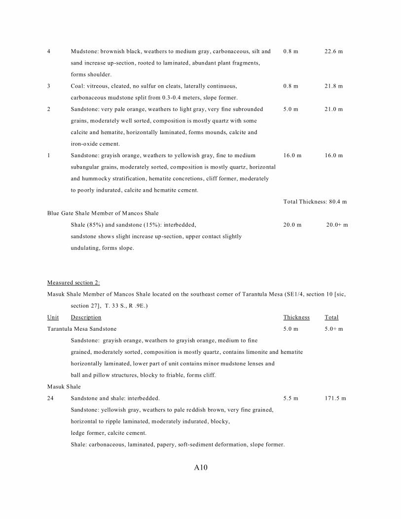
Measured section 7:
Muley Canyon Sandstone Member of Mancos Shale measured at west fork, Muley Canyon (SE1/4, section 19, T. 33

A9
S., R. 9 E.)
Unit Description Thickness Total
Masuk Shale M ember of M ancos Shale
Mudstone and siltstone: interbedded, slope former. 5.0 m 5.0+ m
Muley Canyon Sandstone
14 Sandstone: grayish orange, weathers yellowish gray, massive channels, 10.0 m 80.4 m
forms cliff.
13 Sandstone: grayish orange, weathers to yellowish gray, fine to medium 11.0 m 70.4 m
subrounded grains, moderately sorted, composition is mostly quartz with some
chert, massive channels, cross-bedding, limonite and siderite nodules,
hematite-rich cap, cliff former, iron-oxide cement.
12 Sandstone: very pale to pale orange, weathers to yellowish gray, fine to 9.0 m 59.4 m
medium subrounded grains, moderately sorted, composition is quartz, massive
channels, trough cross-bedding, iron-stone cap, ledge former, poorly
indurated, calcite and hematite cement.
11 Sandstone, mudstone and coal: interbedded, poorly exposed. 6.0 m 50.4 m
Sandstone (65%): grayish orange weathers to grayish orange, silt to
very fine grains, thin bedded, iron-oxide cement.
Mudstone (30%): brownish black, weathers to greenish gray,
carbonaceous, silty to sandy in places, laminated to rooted, abundant
macerated plant fragments, soft-sediment deformation.
Coal (5%): 0.3 m thick.
10 Sandstone: yellowish gray, very fine to fine subangular grains, 18.0 m 44.4 m
moderately sorted, horizontal, inclined, and rippled laminations,
siderite and limonite concretions, cliff former, calcite cement.
9 Coal: vitreous, minor gypsum, cleated, pinches out, forms slope. 0.6 m 26.4 m
8 Mudstone: brownish black, weathers to medium gray, carbonaceous, sandy, 1.6 m 25.8 m
thinly laminated in middle of unit, rooted at top and bottom of unit, plant
fragments along bedding planes, undulating upper contact, forms ledgy
slopes.
7 Coal: vitreous, flaky, low sulfur, laterally continuous, forms slope. 0.4 m 24.2 m
6 Mudstone: brownish black, weathers to medium gray, carbonaceous, sandy, 0.5 m 23.8 m
horizontally laminated, minor rooting, slope former.
5 Sandstone: light gray, weathers to light gray, very fine grains, minor hematite, 0.7 m 23.3 m
contains minor coal lense, lithology changes laterally, slope former.
A10
4 Mudstone: brownish black, weathers to medium gray, carbonaceous, silt and 0.8 m 22.6 m
sand increase up-section, rooted to laminated, abundant plant fragments,
forms shoulder.
3 Coal: vitreous, cleated, no sulfur on cleats, laterally continuous, 0.8 m 21.8 m
carbonaceous mudstone split from 0.3-0.4 meters, slope former.
2 Sandstone: very pale orange, weathers to light gray, very fine subrounded 5.0 m 21.0 m
grains, moderately well sorted, composition is mostly quartz with some
calcite and hematite, horizontally laminated, forms mounds, calcite and
iron-oxide cement.
1 Sandstone: grayish orange, weathers to yellowish gray, fine to medium 16.0 m 16.0 m
subangular grains, moderately sorted, composition is mostly quartz , horizontal
and hummocky stratification, hematite concretions, cliff former, moderately
to poorly indurated , calcite and hematite cement.
Total Thickness: 80.4 m
Blue Gate Shale Member of M ancos Shale
Shale (85%) and sandstone (15%): interbedded, 20.0 m 20.0+ m
sandstone shows slight increase up-section, upper contact slightly
undulating, forms slope.
Measured section 2:
Masuk Shale Member of Mancos Shale located on the southeast corner of Tarantula Mesa (SE1/4, section 10 [sic,
section 27], T. 33 S., R .9E.)
Unit Description Thickness Total
Tarantula Mesa Sandstone 5.0 m 5.0+ m
Sandstone: grayish orange, weathers to grayish orange, medium to fine
grained, moderately sorted , composition is mostly quartz , contains limonite and hematite
horizontally laminated, lower part of unit contains minor mudstone lenses and
ball and pillow structures, blocky to friable, forms cliff.
Masuk Shale
24 Sandstone and shale: interbedded. 5.5 m 171.5 m
Sandstone: yellowish gray, weathers to pale reddish brown, very fine grained,
horizontal to ripple laminated, moderately indurated , blocky,
ledge former, calcite cement.
Shale: carbonaceous, laminated, papery, soft-sediment deformation, slope former.

A11
23 Sandstone: yellowish gray, weathers to pale reddish brown, very fine to 3.0 m 166.0 m
fine subrounded grains, moderately sorted, ripple laminations,
herring-bone structures, channeled , slightly bioturbated, slaty,
ledge former, calcite cement.
22 Shale: brownish black, weathers to a light gray soil, gypsiferous, 7.0 m 163.0 m
thinly laminated, papery, slope former.
21 Sandstone: grayish orange, weathers slightly darker, very fine to fine 3.5 m 156.0 m
subrounded grains, moderately well sorted, ripple laminations, low-angle
bimodal cross-bedding, thins laterally, lower contact undulating, ledge former.
20 Mudstone: brownish black to greenish gray, weathers to brownish gray soil, 5.0 m 152.5 m
carbonaceous, contains abundant gypsum, sulfur and macerated plant material,
rooted, slope former.
19 Silty sandstone and mudstone: interbedded. 10.0 m 147.5 m
Sandstone: yellowish gray, abundant limonite, thin bedded, slope former.
Mudstone: poorly exposed, gypsiferous.
18 Sandstone: light brown, very fine subangular quartz grains, moderately 3.0 m 137.5 m
sorted , wavy laminations, hematite-rich sandstone cap,
ledge former, calcite cement.
17 Mudstone and sandstone: interbedded. 2.0 m 134.5 m
Mudstone: calcareous, gypsiferous, limonitic, ripple laminated.
Sandstone: very fine subrounded grains, herring-bone structures,
ripple laminations, soft-sediment deformation; entire unit forms slope.
16 Mudstone: poorly exposed, brownish black, weathers to light gray soil. 21.0 m 132.5 m
15 Sandstone: well indurated, ripple laminated, forms shoulder, calcite and 7.0 m 111.5 m
iron-oxide cement.
14 Mudstone: weathers to a brownish gray soil, gypsiferous, limonitic, bentonite 13.0 m 104.5 m
horizon, thinly laminated to rooted, abundant plant fragments, contains thin
coal seam.
13 Sandstone: reddish brown to light gray, very fine subrounded quartz grains, 1.0 m 91.5 m
moderately sorted, horizontal and ripple laminations, ledge former,
calcite and iron-oxide cement.
12 Conglomerate and mudstone: cobbles, pebbles, coarse and medium 1.5 m 90.5 m
sand grains in a clayey matrix, very angular clasts, poorly sorted,
abundant limonite nodules.
11 Sandstone and mudstone: interbedded, poorly exposed, light gray soil, 6.5 m 89.0 m

A12
contains a bentonitic soil, unit coarsens upward, slope former.
10 Sandstone: grayish orange, very fine to fine subangular grains, 2.5 m 82.5 m
moderately sorted, laminated to thin bedded, ripple laminated, unit thins
laterally, undulating lower contact, ledgy slope former, calcite cement.
9 Mudstone and siltstone: interbedded, poorly exposed, weathers to a grayish 11.5 m 80.0 m
orange soil, contains abundant limonite and minor gypsum, slope former.
8 Mudstone and minor interbedded sandstone: buried, weathers to a yellowish 12.0 m 68.5 m
gray and grayish orange soil; mudstone: gypsiferous, carbonaceous, hematitic,
forms slope; sandstone: very fine to fine grains, thin bedded.
7 Mudstone: brownish black, weathers to a yellowish gray soil, carbonaceous, 7.0 m 56.5 m
contains gypsum and limonite, silty, laminated, forms slope.
6 Sandstone: yellowish gray, weathers to pale red, very fine to fine angular 6.0 m 49.5 m
grains, channeling, cross-bedding, soft-sediment deformation into lower
unit, cliff former, calcite and iron-oxide cement.
5 Sandstone and mudstone: interbedded. 14.5 m 43.5 m
Mudstone (80%): weathers light brown, laminated, forms slope, calcite and
gypsum cement.
Sandstone: grayish orange, bimodal cross-bedding,
soft-sediment deformation into mudstone, ledge and slope former; sandstone
increases up-section.
4 Shale: light gray, gypsiferous, laminated, forms slope. 3.0 m 29.0 m
3 Shale: dark brown, weathers to a light brown soil, gypsiferous, 15.0 m 26.0 m
laminated, slope former, contains minor sandstone lenses.
2 Sandstone: grayish orange, weathers to grayish orange, fine subangular 3.0 m 11.0 m
grains, moderately well sorted, cross-bedding, channels, ironstone cap,
soft-sediment deformation into lower unit, ledge former, limonite cement.
1 Mudstone: greenish gray, weathers to a light greenish gray soil, 8.0 m 8.0 m
calcareous, gypsiferous, rooted, slope former.
Total Thickness: 171.5 m
Muley Canyon Sandstone Member of M ancos Shale not measured
Measured section B:
Type section of the T arantula Mesa Sandstone (NE1/4SE1/4, section 35, T. 32 S., R. 9 E.)

A13
Unit Description Thickness Total
Tarantula Mesa Sandstone
11 Sandstone: grayish orange, weathers to alternating pale orange and light gray 24.0 m 124.5 m
beds, very fine to fine angular grains, moderately well sorted,
composition is limonite-stained quartz, massive channels, trough cross-bedded,
hematite concretions, hematite-rich beds at four intervals, ledgy
slope former, limonite cement.
10 Sandstone: grayish orange, weathers pale orange to light gray, fine to 15.0 m 100.5 m
medium subrounded grains, moderately sorted, composition is mostly quartz ,
limonite and hematite concretions, massive channels, trough cross-bedded,
forms ledgy slopes, poorly indurated to friable, limonite cement.
9 Sandstone: grayish orange, fine to medium angular grains, moderately 8.0 m 85.5 m
sorted , composition is quartz, abundant hematite and limonite concretions,
trough cross-bedded, massive channels, hematite-rich cap, cliff former.
8 Conglomerate and sandstone: interbedded. 12.0 m 77.5 m
Conglomerate (40% ): yellowish gray, weathers to pale red, very coarse sand
grains, granules, and small pebbles, well rounded, poorly sorted,
composition is mostly chert, poorly indurated.
Sandstone (60%): grayish orange, very fine to fine grains,
composition is mostly quartz with some chert, hematite and limonite
concretions, cross-bedded, forms cliff.
7 Sandstone: light gray weathers to pale red, very fine to fine angular 17.0 m 65.5 m
grains, moderately sorted, composition is mostly quartz, minor hematite and
limonite concretions, very thick to massive channels, cross-bedded,
horizontal and climbing ripples, hematite-rich cap, cliff former, silica
cement.
6 Sandstone: pale orange to light gray, weathers to pale red, fine subangular 22.0 m 48.5 m
grains, moderately well sorted, composition is mostly quartz, massive
channels, cross-bedded, horizontal and climbing ripples, forms cliff, silica
cement.
5 Sandstone: very fine to coarse angular grains, poorly sorted, 9.0 m 26.5 m
composition is 80% quartz, 10% chert, and 10% altered feldspar, hematite and
limonite concretions, massive channels, horizontal and climbing ripples,
cross-bedded, minor bioturbation, minor interbedded jet laminations,
cliff former.

A14
4 Mudstone and silty sandstone: interbedded. 1.5 m 17.5 m
Mudstone: brownish black, weathers to brownish gray, laminated,
gypsiferous, contains ironstone horizon.
Sandstone: yellowish gray, thin bedded; entire unit contains ball
and pillow structures and coarsens upward, forms slope.
3 Sandstone: grayish orange, weathers to yellowish gray, very fine to fine 9.0 m 16.0 m
angular grains, moderately sorted, composition is mostly quartz, hematite
concretions, massive channels, horizontal ripples, cross-bedding,
bioturbation, lower half of unit forms cliff while upper half forms
slope, calcite cement.
2 Sandstone: grayish orange, weathers to yellowish gray, very fine to fine 3.0 m 7.0 m
subangular grains, moderately well sorted, composition is mostly quartz,
massive bedding, low-angle cross-laminations, minor hematite
concretions, forms slope, unit thins latera lly, friable, calcite cement.
1 Sandstone: grayish orange, weathers to yellowish gray, silt to very fine 4.0 m 4.0 m
angular grains, composition is quartz (95%) and iron minerals (5%), ripple and
deformed laminations , low-angle cross-bedding, undulating lower
contact, unit thickens and thins laterally, contains minor mudstone
lenses, forms cliff, poorly indurated , calcite cement.
Total Thickness: 124.5 m
Masuk Shale Member of Mancos Shale:
Mudstone and sandstone: interbedded. not measured
Recommended