!!
!!
KeewatinoowCamp
Excavated MaterialPlacement Area (EMP)
EMP
EMP
CP-LUse-100
CP-LUse-100
N e l so n R
i ve r
KW-Eco-301
KW-Eco-300KW-Aqua-100
KW-Aqua-101
KW-Aqua-101
¾À290
815500
815500
816000
816000
816500
816500
817000
817000
817500
817500
818000
818000
818500
818500
819000
819000
6295
000
6295
000
6295
500
6295
500
6296
000
6296
000
6296
500
6296
500
Coordinate System: UTM Zone 14N NAD83Data Source: MB Hydro, ProvMB, NRCANDate Created: October 24, 2013
±
1:10,000
0 250 500125Metres
Bipole III Transmission ProjectConstruction Environmental Protection Plan
Keewatinoow C.S. and Infrastructure and Ground Electrode Site
Environmentally Sensitive Site Locations
ESS LegendEcosystem!! Species of Concern
WaterWater Crossing
Land UseChurchill WMA
Land Base
WatercourseProvincial RoadsProvincial Highways
Waterbodies
Project InfrastructureBPIII Final Preferred RouteKeewatinoowConverter Station
Ground ElectrodeWork Area Zone Map 1
Manitoba Hydro &Contractor Work Area
Excavated Material PlacementArea
Borrow Deposits
Access Road SecurityGatehouse
Construction Power LineGround Elecrode Line

MAP NUMBER : 1 ESS Group : Conservation
Sec ID ESS ID ESS Name Location Easting Northing UTM Zone
CP CP-LUse-100 Churchill Wildlife Management Area Entire Extent of Map 1 - - 14N
Potential Effects: Within the Churchill Wildlife Management Area Specific Mitigation:
• Must not place food for the purpose of attracting, feeding or holding polar bears • All project staff must record all polar bears encountered/observed on a daily basis, any observations of polar bears or polar
bear tracks must be reported to the MH Site Environmental Officer or MH Environmental Inspector • All garbage must be stored in bear proof containers or within electric fencing and removed from Wildlife Management Area • Clearing within the ROW will be kept to a minimum and with non -non-hazard trees removed. Any trees that are cleared must
be cut, piled and burned under safe conditions • Carry out construction activities on well frozen ground in wetlands
ESS Group : Species of Concern
Sec ID ESS ID ESS Name Easting Northing UTM Zone
KW KW-Eco-300 Species of Concern (plant) 817260 6295132 14N
KW KW-Eco-301 Species of Concern (plant) 817314 6295085 14N Potential Effects: Loss of plants of conservation concern from clearing and construction activities. Specific Mitigation:
• Non-mitigable due to complete removal of all vegetation cover for site. ESS Group : Water Crossing
Sec ID ESS ID ESS Name Easting Northing Channel Width (m)
Wet Width (m)
Fish Habitat Class
Habitat Sensitivity
KW KW-Aqua-100
Unnamed Tributary of Nelson River
- - N/A N/A N/A N/A
KW KW-Aqua-101
Unnamed Tributary of Nelson River
- - N/A N/A N/A N/A
Potential Effects: Increased erosion & sedimentation of streams; damage to stream banks; loss of riparian vegetation; fish habitat disturbances and impeded fish movement; rutting of floodplain.
Specific Mitigation:
• Carry out construction activities on frozen ground to minimize surface damage, rutting and erosion • Use existing trails, roads or cut lines whenever possible as access routes • Identify and flag buffer areas prior to start of work • Riparian Buffers shall be a minimum of 30m and increase in size based on slope of land entering waterway. Within these
buffers shrub and herbaceous understory vegetation will be maintained along with trees that do not violate Manitoba Hydro Vegetation Clearance Requirements
• 7m no machine zone will restrict equipment in close proximity to the waterbody except at the trail crossing • Adhere to Department of Fisheries and Oceans (DFO) Operational Statements for Temporary Stream Crossings, Ice Bridges
and Snow Fills, and Overhead Line Construction

!!
!!
!!!!
!!
!!!!
!!!!
!!
!!
!!
!!
Work Area
KeewatinoowCamp
EMP
EMP
Stockpile
EMP
BorrowDeposit
EMP
BorrowDeposit
KW-Eco-302
CP-LUse-100
Work Area
F i f t e e nC r e e k
F o u r t e e n C r e e k
N e l so n R
i ve r
KW-Aqua-301
KW-Aqua-300
KW-Eco-303
KW-Eco-304
KW-Eco-309
KW-Eco-312KW-Eco-311
KW-Eco-313
KW-Eco-307KW-Eco-306
KW-Eco-305
KW-Eco-310KW-Eco-308
KW-Aqua-104
KW-Aqua-102
KW-Aqua-106
KW-Aqua-105
KW-Aqua-103
KW-Aqua-101
KW-Aqua-101
KN36 Cons
tructio
n Pow
er
KW-Aqua-106
KW-Aqua-108
Work Area
ConstructionPower Station
KeewatinoowLagoon
KN36 Cons
tructio
n Pow
er
¾À290
815000
815000
815500
815500
816000
816000
816500
816500
817000
817000
817500
817500
818000
818000
818500
818500
6292
500
6292
500
6293
000
6293
000
6293
500
6293
500
6294
000
6294
000
6294
500
6294
500
Coordinate System: UTM Zone 14N NAD83Data Source: MB Hydro, ProvMB, NRCANDate Created: October 24, 2013
±
1:10,000
0 250 500125Metres
Bipole III Transmission ProjectConstruction Environmental Protection Plan
Keewatinoow C.S. and Infrastructure and Ground Electrode Site
Environmentally Sensitive Site Locations
ESS LegendEcosystem!! Species of Concern
Water!! Water Crossing
WaterWater Crossing
WaterWater Crossing
Land UseChurchill WMA
Land Base
WatercourseProvincial RoadsProvincial Highways
Waterbodies
Project InfrastructureBPIII Final Preferred RouteKeewatinoowConverter Station
Ground ElectrodeWork Area Zone Map 2
Manitoba Hydro &Contractor Work Area
Excavated Material PlacementArea
Borrow Deposits
Access Road SecurityGatehouse
Construction Power LineGround Elecrode Line

MAP NUMBER : 2 ESS Group : Conservation
Sec ID ESS ID ESS Name Location Easting Northing UTM Zone
CP CP-LUse-100 Churchill Wildlife Management Area Entire Extent of Map 2 - - 14N
Potential Effects: CP-LUse-100: Within the Churchill Wildlife Management Area Specific Mitigation:
• Must not place food for the purpose of attracting, feeding or holding polar bears • All project staff must record all polar bears encountered/observed on a daily basis, any observations of polar bears or polar
bear tracks must be reported to the MH Site Environmental Officer or MH Environmental Inspector • All garbage must be stored in bear proof containers or within electric fencing and removed from Wildlife Management Area • Clearing within the ROW will be kept to a minimum and with non -non-hazard trees removed. Any trees that are cleared must
be cut, piled and burned under safe conditions • Carry out construction activities on well frozen ground in wetlands
ESS Group : Species of Concern
Sec ID ESS ID ESS Name Easting Northing UTM Zone
KW KW-Eco-302 Species of Concern (plant) 816418 6293878 14N KW KW-Eco-303 Species of Concern (plant) 816418 6293878 14N KW KW-Eco-304 Species of Concern (plant) 816575 6293727 14N KW KW-Eco-305 Species of Concern (plant) 816146 6293427 14N KW KW-Eco-306 Species of Concern (plant) 816139 6293400 14N KW KW-Eco-307 Species of Concern (plant) 816153 6293382 14N KW KW-Eco-308 Species of Concern (plant) 816437 6293267 14N KW KW-Eco-309 Species of Concern (plant) 816411 6293207 14N KW KW-Eco-310 Species of Concern (plant) 816455 6293258 14N KW KW-Eco-311 Species of Concern (plant) 816073 6292988 14N KW KW-Eco-312 Species of Concern (plant) 816120 6292933 14N
Potential Effects: Loss of plants of conservation concern from clearing and construction activities. Specific Mitigation:
• Non-mitigable due to complete removal of all vegetation cover for site.
ESS Group : Water Crossing
Sec ID ESS ID ESS Name Easting Northing Channel Width (m)
Wet Width (m)
Fish Habitat Class
Habitat Sensitivity
KW KW-Aqua-101
Unnamed Tributary of Nelson River
- - N/A N/A N/A N/A
KW KW-Aqua-102
Unnamed Tributary of Nelson River
- - N/A N/A N/A N/A
Potential Effects: Increased erosion & sedimentation of streams; damage to stream banks; loss of riparian vegetation; fish habitat disturbances and impeded fish movement; rutting of floodplain.
Specific Mitigation:
• Carry out construction activities on frozen ground to minimize surface damage, rutting and erosion • Use existing trails, roads or cut lines whenever possible as access routes • Identify and flag buffer areas prior to start of work • Riparian Buffers shall be a minimum of 30m and increase in size based on slope of land entering waterway. Within these
buffers shrub and herbaceous understory vegetation will be maintained along with trees that do not violate Manitoba Hydro Vegetation Clearance Requirements
• 7m no machine zone will restrict equipment in close proximity to the waterbody except at the trail crossing • Adhere to Department of Fisheries and Oceans (DFO) Operational Statements for Temporary Stream Crossings, Ice Bridges
and Snow Fills, and Overhead Line Construction
ESS Group : Water Crossing
Sec ID ESS ID ESS Name Easting Northing Channel Width (m)
Wet Width (m)
Fish Habitat Class
Habitat Sensitivity
KW KW-Aqua-103
Unnamed Tributary of Nelson River
- - N/A N/A N/A N/A
Potential Effects:
Increased erosion & sedimentation of streams; damage to stream banks; loss of riparian vegetation; fish habitat disturbances and impeded fish movement; rutting of floodplain. Specific Mitigation:
• Riparian Buffers shall be a minimum of 30m and increase in size based on slope of land entering waterway. Within these buffers shrub and herbaceous understory vegetation will be maintained along with trees that do not violate Manitoba Hydro Vegetation Clearance Requirements.
• 7m no machine zone will restrict equipment in close proximity to the waterbody except at the trail crossing

ESS Group : Wetland
Sec ID ESS ID ESS Name Easting Northing Channel Width (m)
Wet Width (m)
Fish Habitat Class
Habitat Sensitivity
KW KW-Aqua-300
Unnamed wetland - - N/A N/A N/A N/A
KW KW-Aqua-301
Unnamed wetland - - N/A N/A N/A N/A
Potential Effects:
Loss of riparian vegetation, rutting, altered surface water flows. Specific Mitigation:
• Carry out construction activities on frozen ground to minimize surface damage, rutting and erosion • Provide 30 m vegetated (shrub and herbaceous) buffer around site • Remove trees by low-disturbance methods within buffer • The application of herbicides is prohibited within buffer
ESS Group : Water Crossing
Sec ID ESS ID ESS Name Easting Northing Channel Width (m)
Wet Width (m)
Fish Habitat Class
Habitat Sensitivity
KW KW-Aqua-104
Fifteen Creek - - N/A N/A N/A N/A
Potential Effects: Increased erosion & sedimentation of streams; damage to stream banks; loss of riparian vegetation; fish habitat disturbances and impeded fish movement; rutting of floodplain.
Specific Mitigation:
• Carry out construction activities on frozen ground to minimize surface damage, rutting and erosion • Use existing trails, roads or cut lines whenever possible as access routes • Identify and flag buffer areas prior to start of work • Riparian Buffers shall be a minimum of 30m and increase in size based on slope of land entering waterway. Within these
buffers shrub and herbaceous understory vegetation will be maintained along with trees that do not violate Manitoba Hydro Vegetation Clearance Requirements
• 7m no machine zone will restrict equipment in close proximity to the waterbody except at the trail crossing • Adhere to Department of Fisheries and Oceans (DFO) Operational Statements for Temporary Stream Crossings, Ice Bridges
and Snow Fills, and Overhead Line Construction
ESS Group : Water Crossing
Sec ID ESS ID ESS Name Easting Northing Channel Width (m)
Wet Width (m)
Fish Habitat Class
Habitat Sensitivity
KW KW-Aqua-105
Fourteen Creek - - N/A N/A Marginal Low
Potential Effects:
Habitat loss and contamination from structure foundations & installations; increased erosion & sedimentation of streams; damage to stream banks; loss of riparian vegetation; fish habitat disturbances and impeded fish movement; rutting of floodplain.
Specific Mitigation:
• Carry out construction activities on frozen ground to minimize surface damage, rutting and erosion • Use existing trails, roads or cut lines whenever possible as access routes • Identify and flag buffer areas prior to start of work • Riparian Buffers shall be a minimum of 30m and increase in size based on slope of land entering waterway. Within
these buffers shrub and herbaceous understory vegetation will be maintained along with trees that do not violate Manitoba Hydro Vegetation Clearance Requirements
• 7m no machine zone will restrict equipment in close proximity to the waterbody except at the trail crossing • Adhere to Department of Fisheries and Oceans (DFO) Operational Statements for Temporary Stream Crossings, Ice
Bridges and Snow Fills, and Overhead Line Construction • No instream works or fording from April 15 - July 15 ESS Group : Water Crossing
Sec ID ESS ID ESS Name Easting Northing Channel Width (m)
Wet Width (m)
Fish Habitat Class
Habitat Sensitivity
KW KW-Aqua-106
Unnamed Tributary of Nelson River
- - N/A N/A Marginal Low
Potential Effects:
Habitat loss and contamination from structure foundations & installations; increased erosion & sedimentation of streams; damage to stream banks; loss of riparian vegetation; rutting of floodplain
Specific Mitigation:
• Riparian Buffers shall be a minimum of 30m and increase in size based on slope of land entering waterway. Within these buffers shrub and herbaceous understory vegetation will be maintained along with trees that do not violate Manitoba Hydro Vegetation Clearance Requirements
• 7m no machine zone will restrict equipment in close proximity to the waterbody except at the trail crossing

!!
!!
!!
!!
!!
!!
!!
!!
EMP
BorrowDeposit
BorrowDeposit Borrow
Deposit
KW-Hert-101
G o o s eC r e e k
Goose Creek KW-Aqua-301
Constru
ction P
ower L
ine
N E L S ON R I V E R
KW-Eco-314
KW-Eco-313
KW-Eco-316KW-Hert-100
KW-Eco-315
KW-Aqua-109
KW-Aqua-109
KW-Aqua-106
KW-Aqua-109
KW-Aqua-107
KW-Aqua-106
KW-Aqua-108
Work Area
KeewatinoowConverter Station
Keewati
noow
Ground
Elect
rode L
ineAC Collector Lines
Conawapa Road
¾À290
813500
813500
814000
814000
814500
814500
815000
815000
815500
815500
816000
816000
816500
816500
817000
817000
6290
500
6290
500
6291
000
6291
000
6291
500
6291
500
6292
000
6292
000
Coordinate System: UTM Zone 14N NAD83Data Source: MB Hydro, ProvMB, NRCANDate Created: October 24, 2013
±
1:10,000
0 250 500125Metres
Bipole III Transmission ProjectConstruction Environmental Protection Plan
Keewatinoow C.S. and Infrastructure and Ground Electrode Site
Environmentally Sensitive Site Locations
ESS LegendEcosystem!! Species of Concern
Heritage!! Archaeological
Water!! Water Crossing
WaterWater Crossing
Land UseChurchill WMA
Land Base
WatercourseProvincial RoadsProvincial Highways
Waterbodies
Project InfrastructureBPIII Final Preferred RouteKeewatinoowConverter Station
Ground ElectrodeWork Area Zone Map 3
Manitoba Hydro &Contractor Work Area
Excavated Material PlacementArea
Borrow Deposits
Access Road SecurityGatehouse
Construction Power LineGround Elecrode Line
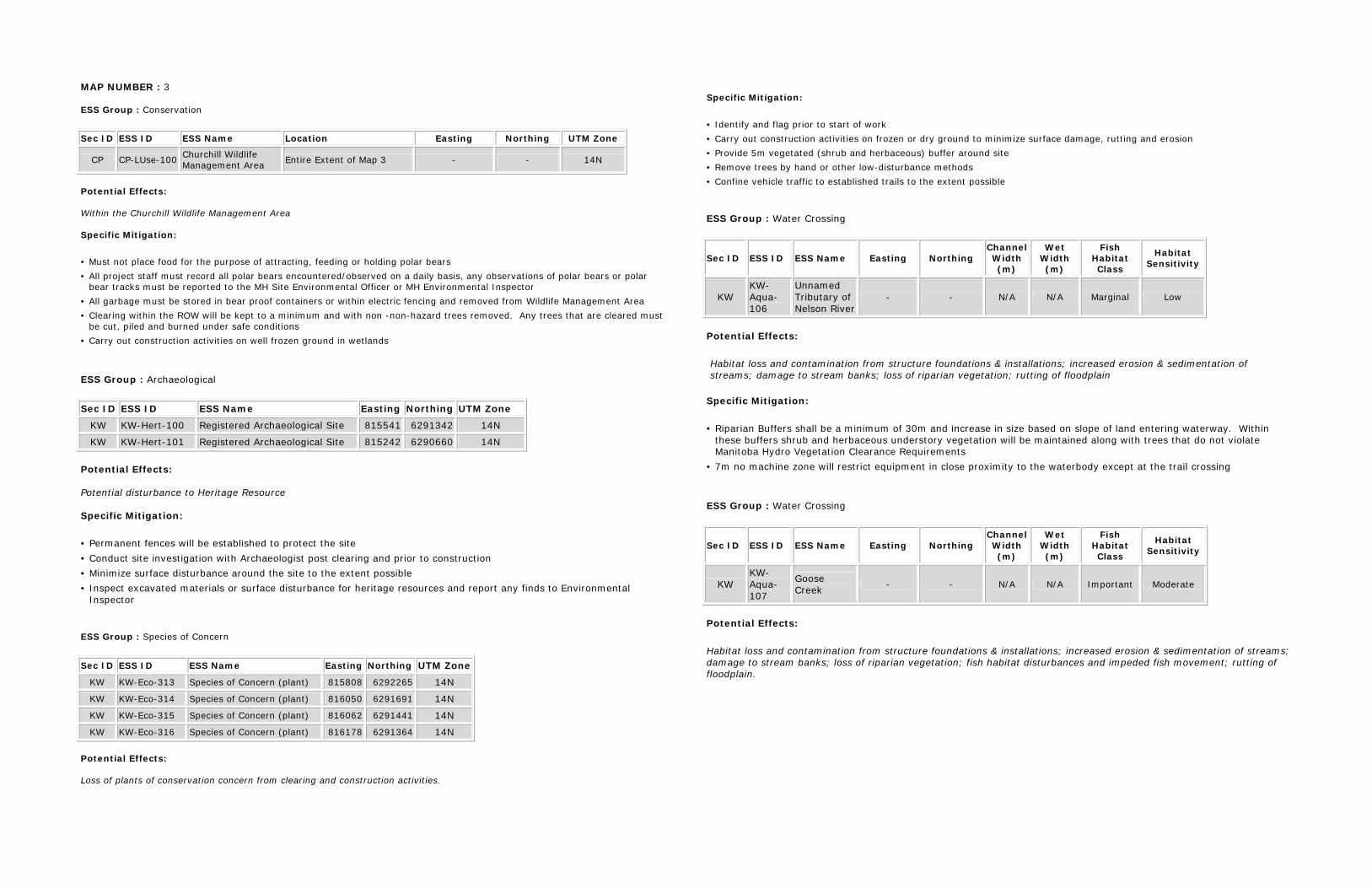
MAP NUMBER : 3 ESS Group : Conservation
Sec ID ESS ID ESS Name Location Easting Northing UTM Zone
CP CP-LUse-100 Churchill Wildlife Management Area Entire Extent of Map 3 - - 14N
Potential Effects: Within the Churchill Wildlife Management Area Specific Mitigation:
• Must not place food for the purpose of attracting, feeding or holding polar bears • All project staff must record all polar bears encountered/observed on a daily basis, any observations of polar bears or polar
bear tracks must be reported to the MH Site Environmental Officer or MH Environmental Inspector • All garbage must be stored in bear proof containers or within electric fencing and removed from Wildlife Management Area • Clearing within the ROW will be kept to a minimum and with non -non-hazard trees removed. Any trees that are cleared must
be cut, piled and burned under safe conditions • Carry out construction activities on well frozen ground in wetlands
ESS Group : Archaeological
Sec ID ESS ID ESS Name Easting Northing UTM Zone
KW KW-Hert-100 Registered Archaeological Site 815541 6291342 14N
KW KW-Hert-101 Registered Archaeological Site 815242 6290660 14N Potential Effects: Potential disturbance to Heritage Resource Specific Mitigation:
• Permanent fences will be established to protect the site • Conduct site investigation with Archaeologist post clearing and prior to construction • Minimize surface disturbance around the site to the extent possible • Inspect excavated materials or surface disturbance for heritage resources and report any finds to Environmental
Inspector ESS Group : Species of Concern
Sec ID ESS ID ESS Name Easting Northing UTM Zone
KW KW-Eco-313 Species of Concern (plant) 815808 6292265 14N
KW KW-Eco-314 Species of Concern (plant) 816050 6291691 14N
KW KW-Eco-315 Species of Concern (plant) 816062 6291441 14N
KW KW-Eco-316 Species of Concern (plant) 816178 6291364 14N Potential Effects: Loss of plants of conservation concern from clearing and construction activities.
Specific Mitigation:
• Identify and flag prior to start of work • Carry out construction activities on frozen or dry ground to minimize surface damage, rutting and erosion • Provide 5m vegetated (shrub and herbaceous) buffer around site • Remove trees by hand or other low-disturbance methods • Confine vehicle traffic to established trails to the extent possible ESS Group : Water Crossing
Sec ID ESS ID ESS Name Easting Northing Channel Width (m)
Wet Width (m)
Fish Habitat Class
Habitat Sensitivity
KW KW-Aqua-106
Unnamed Tributary of Nelson River
- - N/A N/A Marginal Low
Potential Effects:
Habitat loss and contamination from structure foundations & installations; increased erosion & sedimentation of streams; damage to stream banks; loss of riparian vegetation; rutting of floodplain
Specific Mitigation:
• Riparian Buffers shall be a minimum of 30m and increase in size based on slope of land entering waterway. Within these buffers shrub and herbaceous understory vegetation will be maintained along with trees that do not violate Manitoba Hydro Vegetation Clearance Requirements
• 7m no machine zone will restrict equipment in close proximity to the waterbody except at the trail crossing
ESS Group : Water Crossing
Sec ID ESS ID ESS Name Easting Northing Channel Width (m)
Wet Width (m)
Fish Habitat Class
Habitat Sensitivity
KW KW-Aqua-107
Goose Creek - - N/A N/A Important Moderate
Potential Effects:
Habitat loss and contamination from structure foundations & installations; increased erosion & sedimentation of streams; damage to stream banks; loss of riparian vegetation; fish habitat disturbances and impeded fish movement; rutting of floodplain.
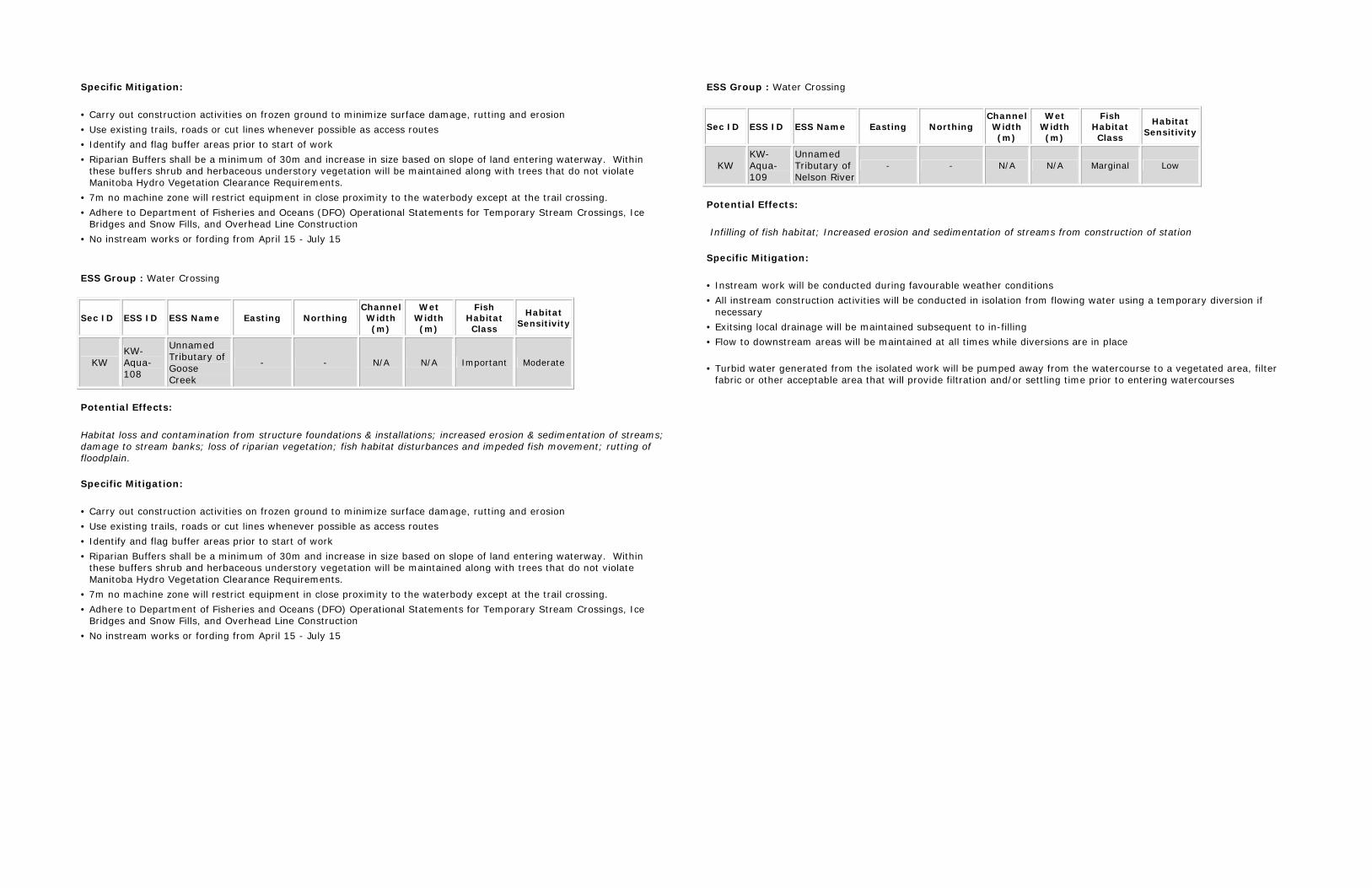
Specific Mitigation:
• Carry out construction activities on frozen ground to minimize surface damage, rutting and erosion • Use existing trails, roads or cut lines whenever possible as access routes • Identify and flag buffer areas prior to start of work • Riparian Buffers shall be a minimum of 30m and increase in size based on slope of land entering waterway. Within
these buffers shrub and herbaceous understory vegetation will be maintained along with trees that do not violate Manitoba Hydro Vegetation Clearance Requirements.
• 7m no machine zone will restrict equipment in close proximity to the waterbody except at the trail crossing. • Adhere to Department of Fisheries and Oceans (DFO) Operational Statements for Temporary Stream Crossings, Ice
Bridges and Snow Fills, and Overhead Line Construction • No instream works or fording from April 15 - July 15
ESS Group : Water Crossing
Sec ID ESS ID ESS Name Easting Northing Channel Width (m)
Wet Width (m)
Fish Habitat Class
Habitat Sensitivity
KW KW-Aqua-108
Unnamed Tributary of Goose Creek
- - N/A N/A Important Moderate
Potential Effects:
Habitat loss and contamination from structure foundations & installations; increased erosion & sedimentation of streams; damage to stream banks; loss of riparian vegetation; fish habitat disturbances and impeded fish movement; rutting of floodplain. Specific Mitigation:
• Carry out construction activities on frozen ground to minimize surface damage, rutting and erosion • Use existing trails, roads or cut lines whenever possible as access routes • Identify and flag buffer areas prior to start of work • Riparian Buffers shall be a minimum of 30m and increase in size based on slope of land entering waterway. Within
these buffers shrub and herbaceous understory vegetation will be maintained along with trees that do not violate Manitoba Hydro Vegetation Clearance Requirements.
• 7m no machine zone will restrict equipment in close proximity to the waterbody except at the trail crossing. • Adhere to Department of Fisheries and Oceans (DFO) Operational Statements for Temporary Stream Crossings, Ice
Bridges and Snow Fills, and Overhead Line Construction • No instream works or fording from April 15 - July 15
ESS Group : Water Crossing
Sec ID ESS ID ESS Name Easting Northing Channel Width (m)
Wet Width (m)
Fish Habitat Class
Habitat Sensitivity
KW KW-Aqua-109
Unnamed Tributary of Nelson River
- - N/A N/A Marginal Low
Potential Effects:
Infilling of fish habitat; Increased erosion and sedimentation of streams from construction of station Specific Mitigation:
• Instream work will be conducted during favourable weather conditions • All instream construction activities will be conducted in isolation from flowing water using a temporary diversion if
necessary • Exitsing local drainage will be maintained subsequent to in-filling • Flow to downstream areas will be maintained at all times while diversions are in place
• Turbid water generated from the isolated work will be pumped away from the watercourse to a vegetated area, filter
fabric or other acceptable area that will provide filtration and/or settling time prior to entering watercourses

!!
!!
Keew
atino
ow
Grou
nd El
ectro
de Li
ne
KW-Aqua-302
BorrowDeposit
BorrowDeposit
BorrowDeposit
BorrowDeposit
BorrowDeposit
KW-Eco-319
KW-Eco-317
KW-Eco-318
KW-A
qua-1
12
KW-Aqua-110
KW-Aqua-111
Work Area
Keewati
noow
Ground
Elect
rode L
ine
Conawapa Road
T i n y
Cr e
e k
C o n a wa p a
Ro a d
NE
L SO
NR I V
E R
¾À290
812500
812500
813000
813000
813500
813500
814000
814000
814500
814500
815000
815000
815500
815500
816000
816000
6288
500
6288
500
6289
000
6289
000
6289
500
6289
500
6290
000
6290
000
Coordinate System: UTM Zone 14N NAD83Data Source: MB Hydro, ProvMB, NRCANDate Created: October 24, 2013
±
1:10,000
0 250 500125Metres
Bipole III Transmission ProjectConstruction Environmental Protection Plan
Keewatinoow C.S. and Infrastructure and Ground Electrode Site
Environmentally Sensitive Site Locations
ESS LegendEcosystem!! Species of Concern
WaterWater Crossing
WaterWater Crossing
Land UseChurchill WMA
Land Base
WatercourseProvincial RoadsProvincial Highways
Waterbodies
Project InfrastructureBPIII Final Preferred RouteKeewatinoowConverter Station
Ground ElectrodeWork Area Zone Map 4
Manitoba Hydro &Contractor Work Area
Excavated Material PlacementArea
Borrow Deposits
Access Road SecurityGatehouse
Construction Power LineGround Elecrode Line

MAP NUMBER : 4 ESS Group : Conservation
Sec ID ESS ID ESS Name Location Easting Northing UTM Zone
CP CP-LUse-100 Churchill Wildlife Management Area Entire Extent of Map 4 - - 14N
Potential Effects: CP-LUse-100: Within the Churchill Wildlife Management Area Specific Mitigation:
• Must not place food for the purpose of attracting, feeding or holding polar bears • All project staff must record all polar bears encountered/observed on a daily basis, any observations of polar bears or polar
bear tracks must be reported to the MH Site Environmental Officer or MH Environmental Inspector • All garbage must be stored in bear proof containers or within electric fencing and removed from Wildlife Management Area • Clearing within the ROW will be kept to a minimum and with non -non-hazard trees removed. Any trees that are cleared must
be cut, piled and burned under safe conditions • Carry out construction activities on well frozen ground in wetlands
ESS Group : Species of Concern
Sec ID ESS ID ESS Name Easting Northing UTM Zone
KW KW-Eco-317 Species of Concern (plant) 814684 6289990 14N
KW KW-Eco-318 Species of Concern (plant) 814276 6289506 14N Potential Effects: Loss of plants of conservation concern from clearing and construction activities. Specific Mitigation:
• Identify and flag prior to start of work • Carry out construction activities on frozen or dry ground to minimize surface damage, rutting and erosion • Provide 5m vegetated (shrub and herbaceous) buffer around site • Remove trees by hand or other low-disturbance methods • Confine vehicle traffic to established trails to the extent possible
ESS Group : Wetland
Sec ID ESS ID ESS Name Easting Northing Channel Width (m)
Wet Width (m)
Fish Habitat Class
Habitat Sensitivity
KW KW-Aqua-302
Unnamed wetland - - N/A N/A N/A N/A
Potential Effects: Loss of riparian vegetation, rutting, altered surface water flows, contamination.
Specific Mitigation:
• Carry out construction activities on frozen ground to minimize surface damage, rutting and erosion • Provide 30 m vegetated (shrub and herbaceous) buffer around site • Remove trees by low-disturbance methods within buffer • The application of herbicides is prohibited within buffer
ESS Group : Water Crossing
Sec ID ESS ID ESS Name Easting Northing Channel Width (m)
Wet Width (m)
Fish Habitat Class
Habitat Sensitivity
KW KW-Aqua-110
Tiny Creek - - N/A N/A Important Moderate
KW KW-Aqua-111
Unnamed Tributary of Nelson River
- - N/A N/A Marginal Moderate
Potential Effects:
Habitat loss and contamination from structure foundations & installations; increased erosion & sedimentation of streams; Damage to stream banks; Loss of riparian vegetation; Fish habitat disturbances and impeded fish movement; Rutting of floodplain Specific Mitigation:
• Carry out construction activities on frozen ground to minimize surface damage, rutting and erosion • Use existing trails, roads or cut lines whenever possible as access routes • Identify and flag buffer areas prior to start of work • Riparian Buffers shall be a minimum of 30m and increase in size based on slope of land entering waterway. Within
these buffers shrub and herbaceous understory vegetation will be maintained along with trees that do not violate Manitoba Hydro Vegetation Clearance Requirements.
• 7m no machine zone will restrict equipment in close proximity to the waterbody except at the trail crossing. • Adhere to Department of Fisheries and Oceans (DFO) Operational Statements for Temporary Stream Crossings, Ice
Bridges and Snow Fills, and Overhead Line Construction • No instream works or fording from April 15 - July 15

!!
!!!!!!
!!
Keew
atino
ow
Grou
nd El
ectro
de Li
ne
BorrowDeposit
BorrowDeposit
BorrowDeposit
BorrowDeposit
KW-Aqua-303
KW-Eco-319
KW-Eco-321KW-Eco-323
KW-Eco-320
KW-Eco-322
KW-Aqua-115
KW-A
qua-1
12
KW-Aqua-114
KW-Aqua-113
KW-Aqua-116
C o n a w a p a R o a dS w i f t
Cr e
e k
N E L S O N
R I V E R
¾À290
811500
811500
812000
812000
812500
812500
813000
813000
813500
813500
814000
814000
814500
814500
815000
815000
6286
000
6286
000
6286
500
6286
500
6287
000
6287
000
6287
500
6287
500
6288
000
6288
000
Coordinate System: UTM Zone 14N NAD83Data Source: MB Hydro, ProvMB, NRCANDate Created: October 24, 2013
±
1:10,000
0 250 500125Metres
Bipole III Transmission ProjectConstruction Environmental Protection Plan
Keewatinoow C.S. and Infrastructure and Ground Electrode Site
Environmentally Sensitive Site Locations
ESS LegendEcosystem!! Species of Concern
WaterWater Crossing
Land UseChurchill WMA
Land Base
WatercourseProvincial RoadsProvincial Highways
Waterbodies
Project InfrastructureBPIII Final Preferred RouteKeewatinoowConverter Station
Ground ElectrodeWork Area Zone Map 5
Manitoba Hydro &Contractor Work Area
Excavated Material PlacementArea
Borrow Deposits
Access Road SecurityGatehouse
Construction Power LineGround Elecrode Line

MAP NUMBER : 5 ESS Group : Conservation
Sec ID ESS ID ESS Name Location Easting Northing UTM Zone
CP CP-LUse-100 Churchill Wildlife Management Area Entire Extent of Map 5 - - 14N
Potential Effects: CP-LUse-100: Within the Churchill Wildlife Management Area Specific Mitigation:
• Must not place food for the purpose of attracting, feeding or holding polar bears • All project staff must record all polar bears encountered/observed on a daily basis, any observations of polar bears or polar
bear tracks must be reported to the MH Site Environmental Officer or MH Environmental Inspector • All garbage must be stored in bear proof containers or within electric fencing and removed from Wildlife Management Area • Clearing within the ROW will be kept to a minimum and with non -non-hazard trees removed. Any trees that are cleared must
be cut, piled and burned under safe conditions • Carry out construction activities on well frozen ground in wetlands
ESS Group : Water Crossing
Sec ID ESS ID ESS Name Easting Northing Channel Width (m)
Wet Width (m)
Fish Habitat Class
Habitat Sensitivity
KW KW-Aqua-112
Unnamed Tributary of Swift Creek
- - N/A N/A N/A N/A
Potential Effects:
Habitat loss and contamination from structure foundations & installations; increased erosion & sedimentation of streams; damage to stream banks; loss of riparian vegetation; rutting of floodplain
Specific Mitigation:
• Riparian Buffers shall be a minimum of 30m and increase in size based on slope of land entering waterway. Within these buffers shrub and herbaceous understory vegetation will be maintained along with trees that do not violate Manitoba Hydro Vegetation Clearance Requirements
• 7m no machine zone will restrict equipment in close proximity to the waterbody except at the trail crossing
ESS Group : Water Crossing
Sec ID ESS ID ESS Name Easting Northing Channel Width (m)
Wet Width (m)
Fish Habitat Class
Habitat Sensitivity
KW KW-Aqua-113
Swift Creek - - N/A N/A Important Moderate
KW KW-Aqua-114
Unnamed Tributary of Swift Creek
- - N/A N/A Marginal Moderate
KW KW-Aqua-115
Unnamed Swift Creek Tributary
- - N/A N/A Marginal Moderate
Potential Effects:
Habitat loss and contamination from structure foundations & installations; increased erosion & sedimentation of streams; damage to stream banks; loss of riparian vegetation; fish habitat disturbances and impeded fish movement; rutting of floodplain. Specific Mitigation:
• Carry out construction activities on frozen ground to minimize surface damage, rutting and erosion • Use existing trails, roads or cut lines whenever possible as access routes • Identify and flag buffer areas prior to start of work • Riparian Buffers shall be a minimum of 30m and increase in size based on slope of land entering waterway. Within
these buffers shrub and herbaceous understory vegetation will be maintained along with trees that do not violate Manitoba Hydro Vegetation Clearance Requirements.
• 7m no machine zone will restrict equipment in close proximity to the waterbody except at the trail crossing. • Adhere to Department of Fisheries and Oceans (DFO) Operational Statements for Temporary Stream Crossings, Ice
Bridges and Snow Fills, and Overhead Line Construction • No instream works or fording from April 15 - July 15
ESS Group : Species of Concern
Sec ID ESS ID ESS Name Easting Northing UTM Zone
KW KW-Eco-319 Species of Concern (plant) 813174 6287968 14N
KW KW-Eco-320 Species of Concern (plant) 813538 6287848 14N Potential Effects: Loss of plants of conservation concern from clearing and construction activities. Specific Mitigation:
• Identify and flag prior to start of work • Carry out construction activities on frozen or dry ground to minimize surface damage, rutting and erosion • Provide 5m vegetated (shrub and herbaceous) buffer around site • Remove trees by hand or other low-disturbance methods • Confine vehicle traffic to established trails to the extent possible

ESS Group : Species of Concern
Sec ID ESS ID ESS Name Easting Northing UTM Zone
KW KW-Eco-321 Species of Concern (plant) 813163 6287384 14N
KW KW-Eco-322 Species of Concern (plant) 813174 6287382 14N
KW KW-Eco-323 Species of Concern (plant) 813181 6287367 14N Potential Effects: Loss of plants of conservation concern from clearing and construction activities. Specific Mitigation:
• Non-mitigable due to complete removal of all vegetation cover for site.
Recommended