Int. Journal for Housing Science, Vol.35, No.3 pp. 185-194, 2011
Published in the United States
0146-6518/03/185-194, 2011
Copyright©2011 IAHS
LANDSCAPE URBANISM FOR SUSTAINABLE CITIES
A. L. Virtudes, F. Almeida
Department of Civil Engineering and Architecture
University of Beira Interior, Covilhã
Portugal
ABSTRACT
The purpose of this article is to rethink the industrial areas in decline for new housing
places. The tendency of planning policies to focus on the building structure at the
expense of ecological elements has led to the abandoning of several urban areas, such
as the old industrial areas. This article presents an urban project for Covilhã (in
Portugal), centered on the ecological element of the stream of Carpinteira. The project
aims to promote the urban rehabilitation and the returning of citizens to this forgotten
area, by integrating the ecological structure and the old industrial buildings together
as landmarks for landscape urbanism. Objectives of this urban rehabilitation project as
promoting the integration and enhancement of the building structure / ecological
component:
- To propose measures of urban design for old industrial buildings and for ecological
component of the stream in order to promote a balance between these two
components of the city;
- To create a leisure area with a riverside walk in order to promote the integration and
enhancement of the stream in the local context and throughout the city;
- To create an ecological corridor to ensure the environmental balance of this area by
integrating the ecological structure into the urban system;
- To allow the rehabilitation of old industrial buildings and, above all, the buildings
heritage that goes back to an industrial past, present in the collective imagination of
the citizens, in order to promote new activities in the derelict industrial buildings and
new housing places;

186 Virtudes and Almeida
In summary, this landscape urbanism proposal aims to qualify and improve the image
of the city.
Key words: Landscape Urbanism, Sustainable City, Rehabilitation, Old Industrial
Areas, Ecological Structure of the City, Housing.
Introduction
Relevance of the ecological structure in the sustainability of the city
The ecological structure and the building structure of the urban system are two of the
main components of the urban landscape. The building structure is a result of the
relationship between society and territory, represented by the inert elements built by
humans, such as roads, buildings, monuments and building facades. The ecological
structure is a component of the urban landscape that includes the “most ecologically
sensitive areas, fundamental to the ecological balance of the city”. From 1999, in
Portugal, the ecological structure of the urban system has been one of the land uses in
urban perimeters along with urbanized areas and planned urbanizations. However, it is
common praxis in planning to privilege the urbanized structure of the city in its built
component to the detriment of the natural structure in its ecological component. This
practice promotes the disregard of the ecological structure of the urban system, like
marginal zones, in the collective image of the city, leading to the inevitable
degradation of the level of enjoyment by the citizens and the disqualification of the
urban image as a whole. In Covilhã, the riparian zones integrate the ecological
structure and the building structures, simultaneously. The building heritage is the
result of the rise of Covilhã as an industrial city since the 17th century, with a factory
existing adjacent to the stream of Carpinteira with foreign technicians, many officials
and weavers worked. The two streams of the city Carpinteira and Goldra are the most
important ecological elements and enclose two valleys in the middle of which lies the
urban fabric. The industrial heritage brings to mind of resident populations as an
identity factor and a challenge to landscape urbanism. In the 18th century the Royal
Cloth Factory was founded alongside the stream of Goldra confirming the potentials
of this industrial city. Covilhã became one of the most important towns in the country
in this domain. Even today there is a strong presence in the collective imagination of
residents and visitors of this factory-town.
A large concentration of manufacturing in the 18th and 19
th centuries is inseparable
from the streams of the city. They become areas with a particular potential for the
creation of significant projects. Its significance is not only socio-economic, cultural
and historical but also environmental because it integrates the ecological structure of
the urban system and at the same time reinforces the identity of the city. With the

Landscape Urbanism 187
decline of the textile industry, the two streams ceased to have any functional role and
only recovered once they returned to become part of the city. The streams have
undergone a long period characterized by measures of devaluation and an oversight of
their potential, triggered by the decline in the wool industry. According to this
thematic, a proposal is presented for a chunk of the stream of Carpinteira,
characterized by a state of neglect and degradation of the ecological and building
structure. The main goal is to return this river to the city and encourage its enjoyment
through the integration and optimization of both structures, creating a new housing
place.
Objectives and Methodology
The landscape urbanism proposes have the following objectives to promote the
integration and valuing of the building structure / ecological structure:
� Landscape urbanism measures to integrate and value the built structure / ecological
structure of the stream, promoting the balance between these two components of
the city that become integrated into a relationship of mutual appreciation by the
quality of urban design;
� Create an ecological corridor to ensure the environmental balance of this area by
integrating the ecological structure of urban system;
� Qualify and improve the Covilhã urban image, rehabilitating this degraded part of
the town;
� Allow the rehabilitation of old buildings, and particularly of the built heritage
which invokes an industrial past, present in the collective imagination of the city,
by using some vacant industrial buildings and warehouses;
� Unblock the waterline, in particular, and the study area, in general, with the
demolition of some of the buildings with no architectural or historical significance;
� Create a leisure space with a riverside walk, to promote the integration and valuing
of the stream not only in the local context but also in the entire city, with the goal
to return it to the enjoyment of citizens, stimulating the interest of the community
for these elements.
The methodology consisted in a first stage in the literature research to clarify the
concepts and meanings that sustain the relevance of the theme, such as landscape
urbanism or sustainable city. The second step involved the analysis and
characterization of the study area: photograph, identification and characterization of
buildings, analysis of the ecological structure, analysis of the relationship with the
environment and conformity with the formal instruments of planning. These two
phases formed the foundation of the landscape urbanism measures adopted in the
design of the proposal.
Characterization of Case Study Area

188 Virtudes and Almeida
The case study area (with 7.88 hectares) is crossed along the stream of Carpinteira
along over 535 meters. The margins with steep topography are bounded by walls of
granite and many old industrial buildings. The built structure (composed by 42
buildings in total) of this riverside system is constituted by a group of scattered
buildings, with a strong presence of industrial buildings, mostly vacant and
deteriorating. For each of these buildings, an identification and characterization card
was created, which consists of the following elements: photo, location plan, typology
(housing, industry, services or otherwise), time of construction, volume (number of
floors), construction area, type of occupation by floor (permanent, temporary or
vacant), integration in the surrounding area, deployment, maintenance or building to
demolish.
The synthesis of these issues allowed us to classify this area as a low population
density and housing. More than half of its buildings are in a poor state of repair or in
ruins and industrial buildings predominate (38%). The nonexistence of facilities and
green spaces for collective use contributes to the local community indifference with
this waterfront. With polluted water and rundown buildings, the waterfront has been
transformed into a smelly and nasty corridor, invisible in the city. This situation
produces negative impacts on the enjoyment and city’s image.
Figure 1 : Case study area. (Source: authors on Google Earth).
Landscape Urbanism Proposal
The creation of a riverside walk (with 900 meters long) is proposed as the landmark to
the integration and enhancement of ecological structure and building structure, which
goes through the terrain, following the longitudinal direction of the stream and
grabbing the natural elements and built elements of the landscape at the same time. In
its relationship with the ecological structure, the ride was designed based on the level
curve of the terrain, adapting it to its characteristics. However, its design in plant is
rectum. This fact accentuates the character of artificial structure of the riverside walk

Landscape Urbanism 189
associated with the urban walls that come up occasionally along the way giving the
sense of inner space.
Figure 2 : Riverside walk. (Source: authors).
The creation of a leisure area is proposed with facilities and green spaces, to help
stimulate the interest of the community by the stream of Carpinteira. The presence of
housing, services and trade offers a range of uses and activities, promoting the
excitement and appreciation of the place. One landscape urbanism proposal which
stands out specifically aimed at the ecological structure is the green corridor of a non
aedificandi area along the stream, which guarantees the protection of its ecological
values. As for project measures specifically aimed at the build structure, rehabilitation
was the watchword, particularly with regard to the old industrial buildings, which
acquire new functions and housing.
Figure 3 : Landscape urbanism design. (Source: authors).
It was designed a symbolic entry on the riverside walk at the edge nearest the center.
By starting the journey on this point we have at the left an educational farm,
distributed in terraces connected by ramps. In order to achieve the objective of
protecting the land of higher agricultural suitability, it is proposed for the area covered
by National Agricultural Reserve an educational farm as a place of awareness with an
educational orientation, focused on environmental issues like organic farming or
composting. This farm is crossed longitudinally by a wooden walkway that integrates
it into the urban context and facilitates access.
190 Virtudes and Almeida
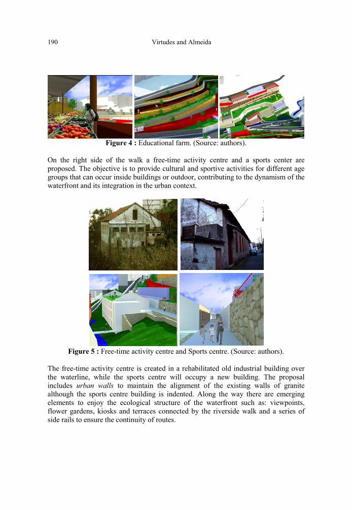
Figure 4 : Educational farm. (Source: authors).
On the right side of the walk a free-time activity centre and a sports center are
proposed. The objective is to provide cultural and sportive activities for different age
groups that can occur inside buildings or outdoor, contributing to the dynamism of the
waterfront and its integration in the urban context.
Figure 5 : Free-time activity centre and Sports centre. (Source: authors).
The free-time activity centre is created in a rehabilitated old industrial building over
the waterline, while the sports centre will occupy a new building. The proposal
includes urban walls to maintain the alignment of the existing walls of granite
although the sports centre building is indented. Along the way there are emerging
elements to enjoy the ecological structure of the waterfront such as: viewpoints,
flower gardens, kiosks and terraces connected by the riverside walk and a series of
side rails to ensure the continuity of routes.

Landscape Urbanism 191
Figure 6 : Elements to enjoy the ecological structure. (Source: authors).
In the transition from one side of the waterline to the opposite side, there is an
existing industrial zone to enhance and integrate. Subjected to the non aedificandi
regime the project measures are small interventions in order to overcome the state of
degradation of the facades of buildings factories, expand existing access ensuring
pedestrian and automobile traffic, guarantee the continuity of the floor and remove
elements impeding the legibility of the landscape and the appreciation of its
ecological and built structures. Some factories in operation will remember the past
and the foundation of this industrial city.
Figure 7 : Industrial zone, before and after intervention (Source: author).
As the industrial buildings it also emerges along the riverside walk multiples green
spaces for collective use. The different heights between terraces are overcome by
ramps and enclosed by walls that are one of the most striking elements of the
waterfront.

192 Virtudes and Almeida
Figure 8 : Green spaces for collective use. (Source: author).
The proposal is for a collective green space of private property of the Riverside
Museum, insert in a complex of ruins of existing industrial buildings introduced in
three altitudinal levels of the margin of the stream. It is intended that this museum will
invoke the history and experience associated with the streams of the city of Covilhã.
Figure 9 : Riverside Museum (Source: author).
Taking advantage of the topographical characteristics of the place, there is next to the
Museum an amphitheatre that is part of the Arts House for the teaching of performing
arts such as music, dance or theatre. At the opposite end from where we started the
route. There is a proposal for a zone of housing, marked by the presence of two new
buildings for collective housing and a student residence resulting from the
rehabilitation of an industrial building, claiming the status of the university city of
Covilhã. Housing (single or collective) comprises a total of 71 houses.
Figure 10 : Collective housing buildings and student residence. (Source: author).
Also in this area we can find office buildings, a silo with 73 public car-parking spaces
and the largest green space for collective use. This is a multifunctional garden, which

Landscape Urbanism 193
allows the enjoyment of a privileged view over the valley of Carpinteira, equipped
with furniture for leisure, relaxation and sport. This garden is larger enough to shelter
events like the Festival of the Garden.
Figure 11 : Biggest green space of collective use. (Source: author).
Next to this garden, there is a proposal for a coffee-bar that uses a ruin of an industrial
building adjacent to the water line to place its esplanade. This type of commerce is not
only useful to occasional users of the waterfront as well as to the residents, including
the student’s residence, located nearby.
Figure 12 : Coffee-bar with esplanade. (Source: authors)
Conclusion
This landscape urbanism proposal aims to demonstrate that urban integration and
mutual appreciation between the ecological structure and building structure can be
rewarding for the sustainable city. These results were achieved by the intervention in
an ecologically sensitive area where we propose the creation of a space socially and
culturally diverse by the amount of green spaces and facilities for collective use,
mainly installed in abandoned industrial buildings. In terms of urban image, this
project transforms a degraded and declining sector of the city into a pleasant place,
skilled and valued in the context of the city. The landscape urbanism proposal scale
allows the drawing based on the observer’s eye, who discovers the city and its spaces
when he is walking, using the method of urban design which combines the laws and
regulation aspects with the qualitative aspects of the urban landscape. Thus it was
possible to achieve the goal of creating a pleasant area and stimulating not only to the
residents but also to these space users. Simultaneously, the urban project considered

194 Virtudes and Almeida
the objectives set at the scale of the city, such as urban regeneration, the life in
community and also environmental concerns. It is understood that this project is only
the beginning of a long multidisciplinary collaboration work between architecture,
civil engineering, town planning, landscape urbanism and others. In order to make its
implementation feasible in the future, there are key aspects to consider, such as the
direct involvement of the local community or the economic and financial viability of
the proposal.
References
1. Almeida, F. Ribeira da Carpinteira – Projecto Urbano: Integrar e Valorizar a
Estrutura Edificada / Estrutura Ecológica, Master Thesis in Architecture,
supervisor: Prof.ª Ana Lídia Virtudes, DECA-UBI.
2. Coelho, A.B. Qualidade do Espaço Público e da Imagem Urbana. AUP, Revista
Urbanismo n.º 5, Lisboa (2000), pp. 26-39.
3. Cullen, G. Paisagem Urbana, Edições 70, Lisboa (1971).
4. Knox, P. and Mayer, H. Small Town Sustainability, Economic, Social, and
Environmental Innovation. Birkhauser, Berlin (2009).
5. Lamas, J. Morfologia Urbana e Desenho da Cidade, Fundação Calouste
Gulbenkian/ JNICT, Lisboa (1993).
6. Lynch, K. A Imagem da Cidade, Edições 70, Lisboa (1960).
7. Magalhães, M. A Arquitectura Paisagista: morfologia e complexidade, Editorial
Estampa, Lisboa (2001)
8. Saraiva, M. O Rio como Paisagem: Gestão de Corredores Fluviais no quadro do
Ordenamento do Território, Fundação Calouste Gulbenkian, Lisboa (1999).
9. Virtudes, A. et al. Planos de Pormenor para a Cidade da Covilhã, Revista
Planeamento n.º2, APPLA, Aveiro (2004), pp. 39-45.
Recommended