i
LANDSLIDE HAZARDS: HOUSEHOLD VULNERABILITY, RESILIENCE AND
COPING IN BUDUDA DISTRICT, EASTERN UGANDA.
By
EKOTU JOHN JUVENTINE
STUDENT NUMBER: 2009094331
Submitted in partial fulfilment of the requirements for the degree
Masters in Disaster Management
In the
Disaster Management Training and Education Centre for Africa
At the
UNIVERSITY OF THE FREE STATE
Study Leader: MS NCUBE ALICE
2012
ii
DECLARATION
I, John Juventine Ekotu, No. 2009094331, hereby declare that this dissertation is a product
of my own independent work and has not previously been submitted for the award of a
similar or related degree in any other university. All sources of information used have been
correctly referenced, and any other assistance rendered has been fully acknowledged.
Signature: …………………………………………..
Author: ………………………………………….. Date: …........………………………
JOHN JUVENTINE EKOTU

iii
ABSTRACT
Landslides are among the most widespread geological hazards that threaten human lives
worldwide, most especially on the mountainous regions of the world. On 1 March 2010, a
devastating debris flow occurred in Nametsi village, Bukalasi Sub County, Bududa district
in Eastern Uganda. The landslide event caused significant damage to farmland, crops, and
livestock; claimed over 400 human lives and displaced an estimated 5,000 people. The
high death toll and damage suffered by households from this landslide suggested high level
vulnerability, absence of resilience and coping mechanisms. This study focuses on the
assessment of household landslide hazard vulnerabilities and vulnerable elements in
Bududa. It addresses the household awareness of landslide hazards, landslide early
warning, mitigation, resilience and coping strategies that have been employed by
households in the area over time. This was a qualitative study with a cross sectional
approach. It was found out that in Bududa, children were the most vulnerable to landslide
hazards followed by the elderly persons. Lack of awareness of landslide hazards, location
of their homes on steep slopes and inability to run away quickly from the threat contributed
to their vulnerability although most households in Bududa have places for evacuation in
case of landslide occurrence. Meanwhile it was established that most people were able to
cope with landslide hazards through prayers to God, the presence of many families around,
talking to friends, support from nongovernment organizations and government. Assistance
from relatives, use of personal savings and migration to other areas within relieved the
impact. However it has been suggested that vulnerabilities in the area could be reduced
through afforestation, proper sitting of houses, restricting settlement and agricultural
activities such as cultivation and grazing on the danger prone areas. Community
participation in the management of natural resources, public awareness campaigns and
outreach programmes are recommended. The relocation of settlements programme that
was fronted by the government requires further investigation to be carried out especially in
terms of willingness to relocate to safer places. Also more work needs to be done in the
area to change production systems, improving household income levels, landslide hazard
mapping, assessment, development of predictive models, early warning and slope
monitoring mechanisms.
iv
DEDICATION
To the Lord God Almighty, who by His grace has seen me through my academic journey to
this level, the glory returns to Him.
My Uncle, Okello William Ocen, my parents John Ekotu and Bridget Atim Ekotu
Thank you for inspiring me always to strive higher, being supportive and exemplary to me.
May the Lord reward you
v
ACKNOWLEDGEMENTS
I am grateful to our Heavenly Farther for the protection, insight, guidance and perseverance
he gave me and my family during the course of conducting this research study. Special
and warm thanks to my wife Jane and my children Johnathan and Jesse for the support,
prayers, motivation, encouragement and the sacrifices they had to make.
I would like to sincerely thank all the people who assisted me to complete this
dissertation. In particular, my father in law, Professor Stephen Olupot Emurwon for the
initial guidance and inspiration you gave me during the early stages of designing this
study.
My supervisor, Ms Alice Ncube of the University of the Free State, Disaster
Management Training and Education Centre, for the tireless guidance you extended
towards me in the course of shaping this work. You were always available for me
whenever I needed your help.
I am indebted to express gratitude to the master‘s programme coordinator, Ms Olivia
Kunguma and the entire DiMTEC team for the great contribution and guidance in
developing this research.
Special thanks go to Professor Rita Niemann from the University of the Free State. You
provided fruitful advice and guidance in the initial stages of developing this research
study.
Regards to Dr Delson Chikobvu for your technical guidance in the process of
developing research tools that have made this work a success. Thank you for your
tireless efforts.
I would like to express my gratitude to Mr Stephen Wamulota, Uganda Red Cross
Society, Eastern Region, Mr Tumwa Wanambwa and a team of research assistants for
the effort you put in during the process of collecting data for this study. Special regards
to Tumwa who doubled as team leader, provided guidance to me and interpretations
during interviews with the key informants. You did a good job.

vi
I wish to thank all the respondents, the Resident District Commissioner (RDC), the
Chief Administrative Officer (CAO), officials in the department of Geology and
Environment Bududa district; the Uganda National Council for Science and Technology
and Office of the Presidents. Without your cooperation, this study would not have been
possible.
My special thanks to Mr Charles Peter Osingada for the remarkable assistance and
guidance in the statistical analysis of the household questionnaire. Thank you for your
costly effort rendered to me free of charge.
To all the friends and the entire DiMTEC classmates, each of you made a contribution
to this work in your different unique ways. Thank you for the moral support and
encouragement.
Special regards to Mr Stephen Amanu and your family in Pretoria, South Africa. I
appreciate your support, constructive advice and encouragement rendered during the
difficult moments of the entire course. God bless you.

vii
TABLE of CONTENTS
DECLARATION ................................................................................................................... ii
ABSTRACT ......................................................................................................................... iii
DEDICATION ..................................................................................................................... iv
ACKNOWLEDGEMENTS.................................................................................................... v
LIST OF FIGURES ............................................................................................................. xii
LIST OF TABLES .............................................................................................................. xiv
ACROYNYMS ................................................................................................................... xv
Chapter One: Introduction ..................................................................................... 1
1.1 Background ........................................................................................................... 1
1.2 Landslide Hazards in Uganda ............................................................................... 2
1.2.1 Landslides in Bududa ..................................................................................... 3
1.2.2 Causes of landslides in Bududa ..................................................................... 4
1.3 Trends in Occurrence of Landslide Disasters and Victims ..................................... 8
1.4 Statement of the Problem .................................................................................... 10
1.5 Objectives of the Study ....................................................................................... 11
1.5.1 Main Objective ............................................................................................. 11
1.5.2 Specific Objectives ....................................................................................... 12
1.6 Study Area .......................................................................................................... 12
1.7 Characteristics of the Study Area ........................................................................ 12
1.7.1 Location ....................................................................................................... 12
1.7.2 Geological Setting ........................................................................................ 13
1.7.3 Topography and Vegetation ......................................................................... 15
1.7.4 Climate and Hydrology ................................................................................. 16
1.7.5 Human and Economic Activities ................................................................... 17
1.7.6 Population and Administration ...................................................................... 18
1.8 Significance of the Study ..................................................................................... 19
1.9 Justification of the Study ..................................................................................... 20
1.10 Scope of the Study .............................................................................................. 21
1.11 Conclusion .......................................................................................................... 22
Chapter Two: Literature Review .......................................................................... 23
2.1 Background ......................................................................................................... 23

viii
2.2 Impact of Landslide Hazard ................................................................................. 25
2.2.1 Physical impact ............................................................................................ 26
2.2.2 Social impact ................................................................................................ 27
2.2.3 Economic impact .......................................................................................... 27
2.2.4 Political impact ............................................................................................. 28
2.2.5 Demographic impact .................................................................................... 29
2.3 Impact of the Bududa Landslides ........................................................................ 30
2.3.1 Deaths and injuries ...................................................................................... 30
2.3.2 Outbreak of disease ..................................................................................... 30
2.3.3 Destruction of infrastructure ......................................................................... 31
2.3.4 Destruction of businesses and personal property ......................................... 31
2.3.5 Destruction of farms, farmland and livestock ................................................ 31
2.3.6 Displacements and relocation ...................................................................... 32
2.4 Types of Landslides ............................................................................................ 32
2.5 The Landslide Hazards ....................................................................................... 36
2.5.1 Types of hazards ......................................................................................... 37
2.6 Landslide Occurrences and Trigger Factors ........................................................ 38
2.7 The Concept of Vulnerability ............................................................................... 40
2.8 Vulnerability Factors ............................................................................................ 41
2.8.1 Social vulnerability ....................................................................................... 41
2.8.2 Physical vulnerability .................................................................................... 43
2.8.3 Economic vulnerability ................................................................................. 43
2.8.4 Environmental vulnerability .................................................................................... 44
2.8.5 Political vulnerability ................................................................................................ 44
2.9 Conceptual Frameworks of Vulnerability ............................................................. 44
2.9.1 The Pressure and Release (PAR) Model ............................................................. 45
2.9.2 Sustainable livelihood (SL) framework ................................................................. 46
2.9.3 The BBC Framework ............................................................................................... 49
2.9.4 The access to resources and coping model ........................................................ 50
2.9.5 Bohle‘s conceptual framework for vulnerability analysis ................................... 52
2.9.6 The International Strategy for Disaster Reduction (ISDR) framework for
disaster risk ............................................................................................................................... 53
2.9.7 The onion framework ............................................................................................... 55

ix
2.9.8 Vulnerability in the global environmental change community ........................... 57
2.9.9 A holistic approach to risk and vulnerability assessment .................................. 58
2.9 Resilience to Hazards ......................................................................................... 60
2.10 Conceptual Frameworks for Resilience ............................................................... 65
2.10.1 The MCEER framework .......................................................................................... 65
2.10.2 Community Resilience Index (CRI) ....................................................................... 67
2.10.3 The Resilience Progression Model ....................................................................... 68
2.11 The Concept of Coping ....................................................................................... 70
2.12 Mechanisms for coping with disaster ................................................................... 72
2.13 Post event coping strategies ............................................................................... 73
2.13.1 Culture of coping with hazards .............................................................................. 74
2.13.2 Relocating settlements ............................................................................................ 74
2.13.3 Emotional and psychological adaptation .............................................................. 75
2.13.4 Support for one another .......................................................................................... 75
2.13.5 Community mobilization .......................................................................................... 75
2.13.6 Personal resources .................................................................................................. 76
2.13.7 Use of social networks ............................................................................................ 76
2.14 Coping Strategies for Landslide Hazards ............................................................ 76
2.15 Conclusion .......................................................................................................... 77
Chapter Three: Research Methodology .............................................................. 78
3.1 Study Design ........................................................................................................... 78
3.2 Study Population ................................................................................................. 78
3.3 Sample Size ........................................................................................................ 78
3.4 Sampling Method ................................................................................................ 79
3.5 Research Tools ................................................................................................... 79
3.6 Data Collection .................................................................................................... 80
3.7 Data Management and Quality Assurance .......................................................... 80
3.8 Ethical Considerations ........................................................................................ 81
3.9 Conclusion .......................................................................................................... 81
Chapter Four: Presentation of Study Findings .................................................. 82
4.1 Introduction ......................................................................................................... 82
4.2 Socio-Demographic Characteristics of Households ............................................. 82
4.2.1 Ownership, type of dwelling and duration of stay ............................................... 83

x
4.2.2 Economic Status of Respondents ......................................................................... 85
4.3 Awareness and Impact of the 2010 Landslides ................................................... 85
4.3.1 Source of information .............................................................................................. 86
4.4 Household Vulnerability to Landslides in Bududa ................................................ 87
4.4.1 Most affected by landslides in Bududa ................................................................. 87
4.4.2 Factors contributing to landslide vulnerability ...................................................... 88
4.5 Coping with Landslides ....................................................................................... 89
4.5.1 Availability and type of evacuation area ............................................................... 89
4.4.2 Household landslide coping mechanisms ............................................................ 90
4.4.3 Ways households reduce the impact of landslides ............................................ 92
4.5 Household Landslide Hazard Resilience ............................................................. 93
4.5.1 Training on landslide hazards and kind of information received ...................... 93
4.5.2 Resilience strategies in Bududa ............................................................................ 95
4.6 Role of Government and NGOS .......................................................................... 96
4.7 Measures by Households to Control Landslides .................................................. 97
4.8 Conclusion .......................................................................................................... 98
Chapter Five: Vulnerabilities, resilience and mitigation measures .................. 99
5.1 Household Vulnerability to Landslides ................................................................. 99
5.1.1 Location of Settlements .......................................................................................... 99
5.1.2 Income levels of households ................................................................................ 100
5.1.3 Unprotected buildings and settlements .............................................................. 100
5.1.4 Special groups at risk ............................................................................................ 100
5.1.5 Lack of disaster preparedness ............................................................................. 101
5.1.6 Government policy ................................................................................................. 101
5.2 Household Awareness of Landslides................................................................. 102
5.3 Warning about Landslides ................................................................................. 103
5.4 Household Resilience and Coping Mechanisms ................................................ 103
5.4.1 Social networking ................................................................................................... 103
5.4.2 Prayer ...................................................................................................................... 104
5.4.3 Relocation of settlements ..................................................................................... 104
5.4.4 Psychosocial support ............................................................................................ 105
5.4.5 Accessing government and nongovernment aid ............................................... 105
5.5 Mitigation Measures .......................................................................................... 106

xi
5.5.1 Slope rehabilitation and afforestation ................................................................. 106
5.5.2 Limiting activities in the hazard prone areas ..................................................... 106
5.5.3 Community participation on development of mitigation measures ................. 106
5.5.4 Public awareness campaign ................................................................................ 107
5.5.5 Government participation ..................................................................................... 107
5.5.6 Early warning and monitoring systems ............................................................... 108
5.6 Conclusion ........................................................................................................ 108
Chapter Six: Conclusions and recommendations ........................................... 109
6.1 Conclusions ...................................................................................................... 109
6.2 Resilience and Coping ...................................................................................... 110
6.3 Suggested Areas for Further Study ................................................................... 110
6.4 Limitations of the Study ..................................................................................... 111
Appendix A: Questionnaire For Household Interview ................................................. 128
Appendix B: Key Informants (KI) Interview Guide ...................................................... 140
Appendix C: Approval By the Uganda National Council For Science And Technology ... 141
Appendix D: Approval By Office Of The President ......................................................... 142

xii
LIST OF FIGURES
Figure 1: Locations where landslide occurred, 1970-1999 shown by dots. Bukalasi and
Nusu zones have the highest number of landslides ever and areas of high risk. --------------- 4
Figure 2: Daily rainfall for Bududa in millimetres (MM) for the months of February and part
of March 2010. -------------------------------------------------------------------------------------------------- 5
Figure 3: Landslide caused by undercutting of the slope for house construction -------------- 6
Figure 4: Half length of the March 2010 Bududa landslide pictured from the opposite hill. - 7
Figure 5: Importance of vegetation in preventing landslides ---------------------------------------- 8
Figure 6: Trends in occurrences of disasters between 1990 to 2010 ----------------------------- 9
Figure 7: Location of March 2010 landslide and boundary of potential future landslide
identified from elevation data and field survey (by newly developing scarp). ------------------ 11
Figure 8: The location of Bududa district in Uganda ------------------------------------------------ 14
Figure 9: Soils in Bududa Nametsi sub-county, photograph taken during the field study. - 15
Figure 10: Part of the Nametsi area with interlocking spurs and funnel-like valleys.
Photograph taken during field study at Nametsi. ----------------------------------------------------- 16
Figure 11: Coffee plantations, vegetables, banana plantation and cattle grazing on the
slopes in bududa, nametsi sub-county. Photographs taken during the field study. ---------- 18
Figure 12: Schematic representation of landslide types ------------------------------------------- 34
Figure 13: The pressure and release (PAR) model ------------------------------------------------- 46
Figure 14: Sustainable livelihood framework --------------------------------------------------------- 48
Figure 15: The BBC conceptual framework. ---------------------------------------------------------- 50
Figure 16: The Access to resources and coping model -------------------------------------------- 51
Figure 17: Bohle‘s conceptual framework for vulnerability analysis. ---------------------------- 53
Figure 18: The International Strategy for Disaster Reduction (ISDR) framework for disaster
risk reduction. ------------------------------------------------------------------------------------------------- 55
Figure 19: The onion vulnerability framework. ------------------------------------------------------- 57
Figure 20: Vulnerability in the global environmental change community framework. ------- 58

xiii
Figure 21: Theoretical framework and model for holistic approach to disaster risk
assessment and management. --------------------------------------------------------------------------- 60
Figure 22: A kind of informal buildings in Bukalasi, Photograph taken during field study. - 84

xiv
LIST OF TABLES
Table 1: Classification of landslide types -------------------------------------------------------------------- 36
Table 2: Classification of hazards ----------------------------------------------------------------------------- 37
Table 3: Socio-demographic characteristics of households --------------------------------------------- 83
Table 4: Ownership, type of dwelling and duration of stay ---------------------------------------------- 84
Table 5: Total annual household income -------------------------------------------------------------------- 85
Table 6: Awareness and impact of the 2010 landslide --------------------------------------------------- 86
Table 7: Source of information for households ------------------------------------------------------------- 87
Table 8: Most affected household members ---------------------------------------------------------------- 88
Table 9: Availability of evacuation area for households -------------------------------------------------- 89
Table 10: Factors for vulnerability to landslides ------------------------------------------------------------ 89
Table 11: Types of evacuation areas available ------------------------------------------------------------ 90
Table 12: Household landslide coping mechanisms ------------------------------------------------------ 91
Table 13: Ways households are reducing landslide impact --------------------------------------------- 93
Table 14: Training on landslide management before 2010 ---------------------------------------------- 94
Table 15: Kind of information received from the training ------------------------------------------------- 94
Table 16: Ways households manage sudden shocks ---------------------------------------------------- 95
Table 17: Expected role by government and non government organizations ----------------------- 97
Table 18: Measures being taken by households to control landslides -------------------------------- 98

xv
ACROYNYMS
BDLG Bududa District Local Government
CBO Community Based Organizations
CDRSS Committee on Disaster Research in the Social Sciences
CRED Centre for Research on the Epidemiology of Disasters
DFID Department for International Development
DRDP Department of Relief and Disaster Preparedness
ECB Economic Capacity Building
ECLAC Economic Commission for Latin America and the Caribbean
LG Local Government
NEMA National Environmental Management Authority
NGO Non Government Organization
OPM Office of the Prime Minister
PAR Pressure and Release Model
PEAP Poverty Eradication Action Plan
UN United Nations
UN-ISDR United Nations International Strategy for Disaster Reduction
UNRA Uganda National Road Authority
URC Uganda Red Cross
USGS United States Geological Survey

1
Chapter One Introduction
1.1 Background
Landslides are among the most widespread geological hazards that threaten lives and property
globally, most especially on the mountainous regions of the world (Huabin, et al., 2005:548;
Jamali & Abdolkhani, 2009:25,). In general, the term is used to describe a wide range of land
forms and processes involving the movement of soil and rock down slope under the influence of
gravity (Reed, 1992:39). They occur as one of the many natural phenomena and are an integral
part of the geological or geomorphologic cycle of landform development through sequential
activity of slopes in any elevated region and especially in young fold mountain chains (Singh,
2010:120). They form part of the processes that shape the surface of the earth. However, when
they threaten mankind, then they present a hazard situation (Shafri, et al., 2010:59). In recent
times, the occurrences of landslides have increased both in frequency and intensity resulting
from a combination of several attributes including geological, morphometric, climatic and
anthropogenetic that directly or indirectly cause slope instability (Singh, 2010:119).
Landslides tend to dislocate objects that they come in contact with, by way of uprooting trees,
destroying utility lines such as telephone, gas, electricity and sewage, tossing vehicles off the
roadways, destruction of roads, railways and bridges (Shafri, et al., 2010:59). They have
assumed catastrophic and disastrous proportions causing extensive damage to life and property
resulting in great problems and serious challenges to man and his development processes
(Singh, 2010:120). Landslides result in injuries and death, induce environmental, physical and
economic damages that impede the development of wealthy as well as poor nations and
regions the world over (Jamali & Abdolkhani, 2009:25).
According to the International Federation of Red Cross and Red Crescent Societies disaster
report (2006:72), it is estimated that in 2005 landslide hazards accounted for about 100,000
deaths worldwide affecting 161 million people, and a total cost of about 160 billion United States
dollars lost. Lacasse & Nadim (2009:32), however, observe that the trend of fatalities due to
natural hazards over the past 100 years shows that the increase in the known numbers of death

2
is due to the increase in the exposed population and the increased dissemination of information,
not an increase in the frequency or severity of natural hazards.
According to the World Bank report (Dilley, et al., 2005:11), the profile of landslide exposure
worldwide is presented with the following dimensions; land area of the globe exposed to
landslides is 3.7 million square kilometres, with an exposed population of 300 million, an
equivalence of five per cent of the total world population. The land area identified as high risk
zone is 820,000 square kilometres and the population living in high risk areas is estimated at 66
million people. The report further points out that the Americas (North, Central and South) and
China in general have borne the highest number of fatalities from landslide hazards.
1.2 Landslide Hazards in Uganda
According to the Committee on Disaster Research in the Social Sciences (CDRSS) (2004:33), a
landslide hazard is described as the potential for occurrence of a damaging landslide within a
given area. Such damage could include loss of life or injury, property damage, social and
economic disruption, or environmental degradation. Uganda has experienced a wide range of
disasters that have affected the country such as displacement of persons as a result of civil
strife, famine as a result of drought, earthquakes, disease epidemics, livestock and crop
disease, flooding, technological accidents as a result of inadequate safety procedures and
landslides resulting from heavy rains and injudicious environmental management (Office of the
Prime Minister (OPM), 2005:2). Landslides, however, have become common phenomena in
Uganda especially on the mountainous areas of the Southwest and Eastern sides where they
have caused extensive damage to property, environment and loss of lives (Office of the Prime
Minister (OPM), 2005:2; Kitutu, et al., 2009:611).
Kizza (2011:1) notes that the African continent was not much affected by landslides or
mudslides in the early days until recently when they have become common. Kitutu, et al.,
(2009:611) observe that in 2002, landslides in Bududa killed three people and injured six. In
2007 they struck Wanale in Mbale district destroying homes and crops of ten families. Over 133
people previously lost their lives due to landslides, the highest number being in 1970 when 60
people were killed in Bulucheke Sub County and Bushenyi district in south western Uganda.
Between 1997 and 1999, 48 people were killed as a result of landslides with over 15,000 left in
displacement after their homes had been destroyed (Kitutu, et al., 2009:611). This increase in

3
occurrences has been attributed to the global warming phenomena resulting in high
precipitation, and poor environmental management practices.
1.2.1 Landslides in Bududa
Landslides have occurred in Bududa since the 1900s. It is now becoming clear that these
disasters are on the increase as the population increases. Landslides in the Mount Elgon areas
and mostly in Bududa, seem to have occurred in the past with little intervention and study.
According to Chenery (1960) in the major soil surveys done in the country the soils of
Bulucheke or the Bududa series in the areas around Mount Elgon were mentioned to be under
risk of soil slips. He reported the presence of cracks in the soils and further mentioned recent
scars of landslips in that year. Bududa District has been affected by landslides some of which
are reported and others not. People mostly report landslides where there is loss of life and many
are never reported (NEMA, 2010:3).
Kitutu, et al. (2009:611), observe that Bududa has increasingly experienced catastrophic
landslides over the past few decades. In 2002, landslides in Bududa killed three people and
injured six. In 2007 they struck Wanale in Mbale district destroying homes and crops of ten
families. On 1 March 2010, another landslide disaster triggered by intense precipitation, which
resulted to slope failure occurred in the mountainous district of Bududa on the slopes of Mount
Elgon, in Eastern Uganda. To be precise, the area affected is located on geographical
coordinates 00 54‘ 48‖ North and 340 19‘ 51‖ East (Figure 22), at an elevation of about 1800
meters above sea level (Kitutu, et al., 2010:8). The landslides swept through three villages of
Nametsi, Kubehwo and Namangasa in Nametsi parish of Bukalasi sub-county destroying
homes, markets, schools and a health clinic killing about 350 people. A total of 106 bodies were
recovered by the rescue teams, and over 250 victims remained missing and were believed to
have been buried under the rubble (Uganda Red Cross, 2010:1). This is arguably one of the
worst landslide disasters to hit the region and the country as a whole in recent times, prompting
the government to declare a state of emergency.
Altogether 516 people have been reported to have been killed by landslides in Bududa since
1933. Thus, in 1933, 25 people were killed when celebrating a harvest; in 1964, 18 people died;
In 1970, about 60 people were killed in one event when celebrating a circumcision ritual; in
1997, 48 people were killed and 10,000 displaced; while in 2010 over 400 people were killed
with over 5,000 left in displacement by landslides (NEMA, 2010:5).

4
Figure 1: Locations where landslide occurred, 1970-1999 shown by dots. Bukalasi and Nusu
zones have the highest number of landslides ever and areas of high risk.
Source: NEMA report (2010:4)
1.2.2 Causes of landslides in Bududa
The activity of land sliding in East Africa, including Bududa ,is generally influenced by heavy
rainfall, steep slopes, slope shape and high clay content in the soil (Knapen, et al., 2006:151).
Other factors that play a role in triggering landslides in this area according to Knapen, et al.,
(2006:151) are the swelling properties of clay and the rate at which water infiltrate into the clay
at depth. According to the report by NEMA (2010:13), it is observed that during intense rain
showers in Bududa, the roads, small footpaths, plot boundaries and runoff ditches concentrate
large volumes of runoff water, and direct this to restricted infiltration zones or hollows. In the
Bududa/Bushika zone, these linear features are numerous and cracks develop upon drying in
the swell–shrink soils. As these cracks form a by-pass mechanism for rapid infiltration, over-
saturation of the zone above the shear plane may occur with subsequent slope failure. Sidle, et
al. (1985), however, observes that other soil properties such as the size of the particles and

5
pore distribution influence slope stability. These will in turn influence the rate of water movement
and the capacity of the soil to hold water. The 2010 landslides were triggered by rains which
lasted for three day (See Figure 2).
Source: Department of Meteorology.
However in Bududa district, over years the occurrence of landslides have also been associated
with community‘s beliefs in myths and superstition related to some mysterious animals (Kitutu,
et al., 2009:618). On the influence of soil properties, Kitutu, et al., (2009:618) observe that
landslide occurrences in Bududa district are mainly conditioned by topography and wet tropical
climate. They observe that the soil type has no influence on landslide occurrence, but soil
texture seem to be significant. In the western zone of Bududa, landslides are due to soil horizon
stratification that favours water stagnation in the lower horizon and are only confined to areas
that experience water stagnation. While in the eastern zone, landslide occurrences are
dependent on a number of factors which include soil texture, depth to the bed rock, land use
and shape of the slope.
Undercutting of slopes in Bududa for construction of houses and roads removes the lateral
support of the slope leading to slope failure (Figure 3). Although slope undercutting mostly
decreases hill slope stability without actually initiating movement, in Bulucheke, for example in
Figure 2: Daily rainfall for Bududa in millimetres (MM) for the months of February and
part of March 2010.

6
2007, the excavation for house building was directly responsible for triggering slope failure and
creep phenomena that caused landslides. Two young girls were killed in this house in 2007
(NEMA, 2010:13).
Figure 3: Landslide caused by undercutting of the slope for house construction
Source: NEMA report (2010:13)
The recent landslides have in most cases been associated with population growth resulting in
increased urbanisation. The most explosive growth has been in developing countries resulting
where urban population has tripled in the last 30 years (Haigh & Amaratunga, 2010:12). The
expansion of settlements is increasing the impact of natural disasters both in the developed and
developing countries (Guzzetti, 2003; Renschler, et al., 2010:15,). Degradation of slopes
through soil loss due to landslides in Bududa District, which lies in eastern Uganda is a problem
with fatalities, environmental consequences and food shortages envisaged in the future.
Farmlands and infrastructure such as bridges and roads are destroyed. These landslides
displace about 11,000,000m3 of soil and debris into river channels and wetlands downstream
(Figure 4 below).
According to the National State of Environment Reports for Uganda for the years 2000 through
to 2007, it is pointed out that land is becoming increasingly scarce as the country‘s population
7
increases at a high rate. The population growth rate for Uganda in the 2002 census stands at
3.4% per year. The mountainous districts of Kabale, Mbale, Manafwa, Bududa and Sironko are
ranked areas with high population density, and the consequences are serious land pressure
leading to land degradation. People are forced to exploit steep slopes for settlement and
agriculture causing land degradation which in the end leads to increased landslides in extreme
cases. In addition, a big percentage of the population depends on agriculture for a living. The
loss of soils leaves the areas bare and non-productive, which creates more pressure on land,
which is already a scarce commodity in some of these areas (NEMA, 2010:3).
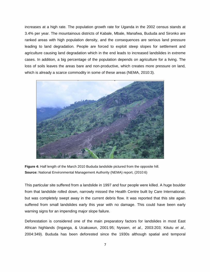
Figure 4: Half length of the March 2010 Bududa landslide pictured from the opposite hill.
Source: National Environmental Management Authority (NEMA) report, (2010:6)
This particular site suffered from a landslide in 1997 and four people were killed. A huge boulder
from that landslide rolled down, narrowly missed the Health Centre built by Care International,
but was completely swept away in the current debris flow. It was reported that this site again
suffered from small landslides early this year with no damage. This could have been early
warning signs for an impending major slope failure.
Deforestation is considered one of the main preparatory factors for landslides in most East
African highlands (Inganga, & Ucakuwun, 2001:95; Nyssen, et al., 2003:203; Kitutu et al.,
2004:349). Bududa has been deforested since the 1930s although spatial and temporal

8
information is lacking. Undoubtedly, the forest stretched much further eastwards, prohibiting
slope failure on the steep slopes with shallow soils in the Bukalasi and Nusu ridge zone.
Stability analysis shows that deforestation decreases the safety factor, which is a measure of
the slope stability, through root decay by 30% to 60% on these slopes. Another indication of the
importance of a forest cover in prohibiting mass movements in the area, is the absence of
landslides under forest on slopes with similar topographic and soil properties as in the Bukalasi
and Nusu zone where landslides do occur.
Figure 5: Importance of vegetation in preventing landslides
Source: NEMA report (2010:14)
1.3 Trends in Occurrence of Landslide Disasters and Victims
According to Guha-Sapir, et al., (2010:1) in 2010, the number of reported disasters
approximated the annual average disaster occurrence during 2000 to 2009, that is, 387. The
number of victims increased from 198.7 million in 2009 to 217.3 million in 2010, but remained
below the annual average number of victims of 227.5 million during 2000 to 2009. Economic
damages of US$ 47.6 billion from natural disasters in 2010 were over 2.5 times higher than in
2009, and increased by 25.3% compared to the annual average for the period 2000-2009 with a
total US$ 98.9 billion (Figure 6).

9
.
Source: Guha-Sapir, et al., (2010:1).
They further observe that, the regional distribution of disaster occurrences in 2010 resembled
the annual average distribution of the last decade. Asia accounted for more than a third of the
number of all reported disasters, 34.8%. The Americas had a 25.2% share of global disaster
occurrence, Europe and Africa both took nearly a fifth of disaster occurrence, that is, 18.2% and
17.9% respectively while Oceania 3.9%. Although Europe saw the biggest increase in disaster
occurrence and Asia had the largest decrease, with fewer victims and damages compared to
the last decade‘s annual averages, the continent still took the largest share of disaster
occurrence and victims in 2010 (Guha-Sapir, et al., 2010:1).
However, according to the CRED The number of victims from hydrological disasters, that is,
Flood and Mass Movements, in 2010 was the highest in a decade, and increased by 98.9%
compared to the yearly average of the last decade. They caused 87.0% of the global reported
number of victims in 2010. Hydrological disasters were responsible for 92.9% of disaster victims
in the Asian continent alone, the highest share since the 1980s. These resulted from extensive
floods and landslides following heavy monsoonal rains in Southern China causing 134.0 million
Figure 6: Trends in occurrences of disasters between 1990 to 2010.
10
victims globally with more than one third of the damages, that is, 37.9% (Guha-Sapir, et al.,
2010:1).
1.4 Statement of the Problem
Landslides are among the most widespread geological hazards that threaten lives and cause
destruction of property globally (World Disaster Report, 2006:11). They continuously result in
human suffering, environmental degradation, property damage and destruction of infrastructure.
Located on the densely populated slopes of Mount Elgon, Bududa has experienced increased
occurrence of landslides since the beginning of the twentieth century (Ole, 2001:1).The latest
and most devastating landslide to occur was in 2010 which left over 350 people dead and made
thousands homeless. Yuri and Shannon, (2010:1) report that mapping of the slope area above
the adjacent village of Murwerwe revealed a newly developed crack between 0.5-2.0m high,
25m long and 9m wide at the apex (Figure 7). The apex of the crack is located at 2,076 meters,
at the same elevation as the apex of the fatal March 1, 2010 Nametsi landslide. The distance
between the two is approximately 300 meters along the convex slope which is completely
covered with crop fields.
They further report that at the bottom of the scarp, a newly developed crack, 10-15 centimetres
wide is visible at a distance of at least 100 meters away. By overlaying field survey data and
elevation model from ASTER GDEM data they found that the apex of the scarp is in the upper-
middle part of the concave slope which is a common location in many landslides. Considering
the very high slopes of up to 60 degrees in the area, the location of the scarp signifies a critical
situation where excess rainfall could trigger another massive landslide. The households in the
area remain vulnerable and susceptible to landslide hazards. Therefore a research study was
required to determine household landslide hazard vulnerabilities, resilience and coping
mechanisms in the area and appropriate mitigation measures that can be devised to minimise
further occurrences and impacts, in case landslides occurred. It was also essential to study
how people in this area perceive landslides and cope with them.

11
Figure 7: Location of March 2010 landslide and boundary of potential future landslide identified from
elevation data and field survey (by newly developing scarp).
Source: Gorokhorich, & Doocy, (2010:1).
1.5 Objectives of the Study
1.5.1 Main Objective
The vulnerability of individuals, communities and the environment is a major factor in exposure
to disaster causing hazards which limits resilience, but these hazards do not affect everybody in
the same way (Cutter, et al., 2003:243). The poor and socially disadvantaged groups are the
most exposed and suffer the greatest impact from disasters (Wisner, et al., 2004:12). Yet these
fragile people groups are most often not given priority in disaster prevention strategies despite
quite clearly being the most vulnerable. Understanding vulnerability factors, populations coping
mechanisms with landslides, how they perceive risk and their priorities are first and key steps
toward developing more effective rural development and landslide risk management
programmes (Anderso,n et al., 2011:591). Therefore the main objective of this study was to
assess household vulnerabilities, resilience and the coping mechanisms to landslides in Bududa
district, Eastern Uganda.
The study aimed at recommending landslide mitigation measures against vulnerability factors
which, if implemented, would reduce the vulnerability of individuals, households and

12
communities to landslide hazards by increasing their resilience capacity to shocks. These
measures would take into consideration the already existing coping mechanisms, related
traditional knowledge and people‘s beliefs surrounding the occurrence of landslides.
1.5.2 Specific Objectives
The specific objectives of the study were to:
(1) To assess household vulnerability factors and risk elements in Bududa.
(2) To evaluate the level of household awareness on landslide hazards.
(3) To examine the landslide hazard early warning, monitoring and mitigation mechanisms.
(4) To assess the capacity of households to cope with landslides and future shocks in Bududa.
1.6 Study Area
The study was conducted in Bududa district, Eastern Uganda (Figure 8), Bukalasi sub-county.
The district of Bududa was systematically selected by the researcher because it has had a long
history of landslide activity in Uganda and besides, it is the most recently affected area. The
sub-county selected, falls under the hazard prone area where populations have been affected
by landslide hazards. This provided a better study population and was able to generate a
better opinion on the assessment conducted. Bududa is one of the districts located on the
slopes of Mount Elgon in Eastern Uganda and has increasingly experienced catastrophic
landslides. During the El Niño rains of 1997, landslides killed 48 people and displaced
thousands in this area. In 2004 over 15,000 people were displaced and made homeless by
landslides (Kitutu, et al., 2009:611). Besides displacement of people, landslides in the area
cause loss of income for farmers, damage to roads and bridges which further constrains the
delivery of service and development initiatives in the district (NEMA, 2010:3).
1.7 Characteristics of the Study Area
1.7.1 Location
Bududa district lies at the foot of the South-Western slopes of the Mount Elgon volcano in
Eastern Uganda. It is geographically bound by latitude 2° 49‘ N and 2° 55‘ N, longitude 34° 15‘
E and 34° 34‘ E (Figure 22). The district comprises one county, seven sub-counties and one

13
town council. The district was named after its chief town Bududa. It was initially part of Manafwa
District as Manjiya County, but it was made a district in 2006. It is bordered by Manafwa District
to the south, Sironko District to the north, Mbale District to the west, and the Republic of Kenya
to the east. Bududa District headquarters are located approximately 23km by road southeast of
Mbale, the largest city in the sub-region (NEMA, 2010:1).
1.7.2 Geological Setting
Geologically, the Bududa region consists of soil types conditioned by topography and tropical
climate namely Nitisols, Cambisols, Lixisols, Ferralsols, Leptosols, Gleysols, and Acrisols
(Kitutu, et al., 2009:611). The geology consists of fenitised basement rocks and in the central
part of Bukigai, a pre-Elgon alkaline volcanic structure, the Butiriku carbonatite complex stands
out (NEMA, 2010:2). The soils in the western side of Bududa are predominantly clay and have
the same texture down the profile. The soils on steep slopes areas are deep and very porous in
the top 100 centimetres of clay loams or clays. They have very little or no laterite with very little
horizon differentiation below the top 20 - 25 centimetres apart from slight changes in firmness.
On the carbonatite dome in the Bukigai area, the soils are clay-rich with more than 30 pe rcent
clay. They are uniformly coloured down the profile with less than 20 per cent change in clay
content. The sand and silt contents decreases down the profile. The soils have a redder hue in
the top horizons and from 40 to 140 centimetres depth they have shiny ped faces (Figure 23)
(Kitutu, et al., 2009:614).

14
Figure 8: The location of Bududa district in Uganda
Source: Kitutu et al., 2010:9

15
Figure 9: Soils in Bududa Nametsi sub-county, photograph taken during the field study.
1.7.3 Topography and Vegetation
Bududa district lies on the slopes of Mount Elgon in Eastern Uganda. It has a unique
topography characterized by stand-alone volcanic cones, interlocking spurs, v-shaped valleys
indicating river incisions, cliffs and ridges, both gently undulating and rugged with bamboo forest
(Figure 24). The altitude varies significantly from 1250 to 2850 meters (5,900 ft) above sea level
(Atuyambe, et al., 2011:3). Kitutu, et al. (2009) observes that Mount Elgon forest and National
Park cover approximately forty per cent of the district.

16
Figure 10: Part of the Nametsi area with interlocking spurs and funnel-like valleys. Photograph taken
during field study at Nametsi.
1.7.4 Climate and Hydrology
The Mount Elgon's ecosystem plays a bigger role in determining the climate patterns in eastern,
central and northern Uganda and western Kenya. The temperatures on the slopes of Mount
Elgon are normally very low because of the high elevation. The study area, which is at an
altitude that ranges from 1250 to 2850 meters above sea level, has relatively low temperatures.
The mean maximum monthly temperature ranges from 21.20C to 23.50 0C. The area
experiences two distinct wet seasons separated by dry periods during the months of December
to February and July (NEMA 2010:2). The precipitation usually peaks in May and October and it
is largely influenced by the high altitude of 1250-2850m and an average of 1,800 m (5,900ft)
above sea level (Kitutu, et al., 2011:8).
Every slope experiences gravitational activity induced by shear stress which increases with
slope height, inclination and unit weight of materials forming the slope. Expansion, contractions
and freezing actions on the slope may contribute to increased shear stresses particularly in the
surface. Under normal circumstances, the shear stress along the slope is in equilibrium with the
shear resistance, however, it can be modified and influenced by external factors such as
increase in the load on the slope from construction activity, increased pore pressure due to

17
intense rainfall, exceptional precipitation and water saturation on the soil; weakening of the soil
and rock layers leading to reduced cohesion for example by mining, excavation, deforestation,
and this may result to land sliding (Singh, 2010:120, Uniyal, 2010:364). Triggers that are known
to cause or reactivate landslides on hilly places include heavy rainfall or snowmelt, earthquake
shaking, erosion, and human activities (Nicoll, 2010:134).
1.7.5 Human and Economic Activities
Agriculture is the most important activity being carried out in the area with a majority of the
people living practising subsistence farming. The fertile volcanic soils and the abundant rainfall
of average 1,500 millimetres per year ensure ample yields of both cash and food crops. The
main crops grown in the area include coffee, beans, bananas, cabbage, tomatoes, onions,
carrots and other green vegetables. Coffee is grown as a cash crop and mainly on small scale.
The people in Bududa also keep animals such as goats, cattle, pigs and chicken (Figure 25).
Other activities in Bududa include small-scale and medium-scale businesses such as retail
shops, food kiosks, restaurants, bars, and transportation. These activities provide the only and
yet infrequent income to the owners

18
Figure 11: Coffee plantations, vegetables, banana plantation and cattle grazing on the slopes in bududa,
nametsi sub-county. Photographs taken during the field study.
1.7.6 Population and Administration
In 2006, the district population was estimated at about 146,000, with a total of 73,861 females
and 74,468 males, placing the ratio at approximately 1:1 respectively (Atuyambe, et al., 2011:3).
According to the Uganda Population and Housing Census Report, the population of Bududa is
steadily growing at a rate of 3.8% per annum (Uganda Bureau of Statistics, 2002:17). According
to Kitutu, et al. (2011:10) Bududa District is densely populated with about 952 persons living per
square kilometre. This seems to imply that the greatly increasing population is responsible for
the high rates of deforestation on the slopes of Mount Elgon in search for settlement and
agricultural land. Administratively, Bududa is largely a rural district with nine urban growth
centres which also serve as lower local governments. There is one town council that is Bududa
Town Council and eight sub-counties which include: Bududa, Bukalasi, Bukibokolo, Bukigai,
Bulucheke, Bumasheti, Bumayoka, and Bushika. (Bududa District Local Government, 2010).
19
1.8 Significance of the Study
The slopes of Mount Elgon have since the early twentieth century experienced increased
occurrence of landslides (Kitutu, et al., 2009:611). In Bududa district, the landslides have
caused loss of lives, destruction of property and displacement of thousands of people into
relocation camps. The conditions in these camps are characterised by dependence on foreign
aid, poor shelter, lack of safe water, clothing, domestic utensils, and breakdown in education
system and food production. At the macro level, economic growth, balance of payment and
public spending are all affected. The funds targeted for development are reallocated to finance
efforts to resettle the affected populations jeopardising the long term national development
goals, as a result, the commitment to pursue productive livelihood through poverty reduction
have been continually frustrated. Therefore the study is significant in a number of ways.
The study provides an assessment of landslide household vulnerability factors, resilience and
coping mechanisms in Bududa. This will inform the national government, nongovernment
organizations (NGOs) and the United Nations (UN) agencies involved in emergency response,
on formulation of appropriate landslide disaster management and response strategies.
The study has generated information which may be used in the decision-making process to
mitigate landslide occurrences. Various government departments and agencies could make use
of the information, thereby being in a position to develop landslide control measures. For
example, the Department of Relief and Disaster Preparedness (DRDP) could use the
information in preparing landslide disaster management plans, which could reduce or avoid
losses from landslides by ensuring prompt assistance to the victims, and achieve rapid and
effective recovery. The information may help in the development of an early warning system for
landslide hazards. The Uganda National Roads Authority (UNRA) could use the information in
planning the road system on the unstable slopes of Mount Elgon in eastern Uganda. The
Department of Lands and Physical Planning could use the information to determine and
recommend best sites for human settlements and agricultural activity on the landslide prone
slopes.
The study could assist individuals, households and communities in the affected areas to
understand better the vulnerability of their physical environments, the danger-prone areas and
risks posed by landslides to their communities. The study provides information on how human

20
activities have contributed to instability of the slopes. This, in the long run, should help the local
people to appreciate the problem, and be more willing to rehabilitate the unstable hill slopes or
relocate from the danger-prone areas.
The information generated is of value to various stakeholders working in the affected areas on
the rehabilitation of individuals, households, community and the physical environment in
Bududa, especially the local government (LG), the government agencies like National
Environmental Management Authority (NEMA) and the NonGovernmental Organizations
(NGOs). These may use the information to rehabilitate the hill slopes, catchment areas resulting
to better environmental protection and management practices in the area. It would also aid the
development of plans to mitigate the impact of landslide hazards, assess the coping
mechanisms and provide recommendations for the mitigation of landslide vulnerability factors in
Bududa and other prone regions.
Finally, the information generated by this study is of academic value. Not much is known about
landslides in Uganda. Most research studies make reference to international landslides instead
of the local case studies. This study will enable the interested and affected parties to appreciate
the extent of the problem in their own geographical setting.
1.9 Justification of the Study
Different hazards have continued to strike different parts of the world at an increasing rate. Their
effects on the victims are, however, similar although the magnitude may vary. In Africa, the
poor, who happen to be the majority, are the most vulnerable in any kind of disaster and in the
same way such disasters have become a powerful downward trigger to poverty, because the
few assets are continually destroyed and funds meant for development activities are diverted to
finance recovery while the investment infrastructure and services get wiped away. Bududa,
Eastern Uganda has been a victim of landslide hazards for long, and have resulted in massive
destruction, loss of lives and displacement of the populations who are left with no productive
livelihood activities.
Landslides have continued to claim human lives, damage property, and infrastructure in the
study area. The continued susceptibility of this area to landslide hazards puts human life,
property and the environment in great danger. There was therefore a need to examine the

21
causes of vulnerability of households to landslides in order to formulate an informed basis for
preventing further loss and destruction of both lives and property. Through the identification of
vulnerabilities, resilience and coping strategies in the area, the study forms part of the basis for
landslide hazard management for Bududa district.
This study provides recommendations that would benefit the government of Uganda in its
commitment to reduce levels of household vulnerabilities to landslides in the mountainous areas
of Bududa and other landslide prone regions in the country. The study contributes towards the
commitment to alleviate suffering of the vulnerable groups such as children, women, disabled
and the elderly by way of providing ideas to improve their resilience, mitigation, coping
mechanisms and recovery from landslide. This supports the achievement of poverty eradication
action plan (PEAP) objectives, currently being implemented by the government of Uganda. The
study informs individuals, households, opinion leaders, the local and international community
involved in disaster management on household vulnerability reduction and other emergency
activities for landslide prone areas in Uganda and elsewhere in the World.
This study is the first attempt to provide an assessment of household vulnerabilities, resilience
and coping with landslide hazards in Eastern Uganda. In that regard therefore the research is
an important step towards bringing together the local understanding of landslide vulnerability,
capacity, and adaptive strategies that have been used by different generations that have
inhabited this area. This is important because it would create better understanding of the
different relationships between the physical environment, humans, and the occurrence of
landslides.
1.10 Scope of the Study
This study was conducted in Bududa district, Eastern Uganda. Bududa district has one county
with seven sub-counties. The study covered Bubiita and Bumayoka sub-counties. These were
strategically selected by the researcher because they are in these sub counties where Bukalasi
parish with the villages of Nametsi, Kubehwo and Namangasi that were affected by the latest
landslide hazard, are located. This means they have the largest number of households that
have been affected by landslide hazards over time and therefore provided a sufficient study
population who have had an encounter with the landslides. The study carried out an
assessment on the household vulnerability factors, resilience and coping strategies to deal with
22
landslide and future shocks. The assessment covers the landslides that have occurred within
the past five years; January 2006 to December 2010.
1.11 Conclusion
Chapter one provides background information to the study and describes the problem,
objectives and significance of the study. Chapter two provides a review of the literature on
landslide hazards, definitions, causes, mechanisms and impacts of landslides. It also provides
literature on theories and models that have been used to explain the concepts of vulnerability,
resilience and coping with disasters. These concepts provide the basis for explanation of
household vulnerability, resilience and coping in Bududa. Chapter three describes the
methodology used in executing this study including the design of the study, sampling
techniques, data collection and analysis. Chapter four provides findings from the field survey
derived from the analysis of data. Chapter five is the synthesis of the findings. It explains the
factors behind household vulnerability, coping and house hold resilience mechanisms. The
chapter also provides the hazard mitigation mechanisms that would increase household
resilience. Chapter six is composed of the major conclusions from the study, recommendations
and highlights areas for further study.
23
Chapter Two Literature Review
2.1 Background
The chapter examines the existing related literature in the area of landslide hazards,
vulnerability factors to landslides, resilience and coping mechanisms. It explores what other
research studies have discovered with particular interest in understanding the concepts of
vulnerability, resilience, coping with current and future shocks in the landslide hazard prone
areas. The chapter points out the characteristics and provides insight into the different
conceptual models used for assessing each of them.
Landslides are one of the most widespread geological hazards on earth, responsible for a
considerable loss of property, economic dislocation, environmental degradation, damage on the
infrastructure, loss of cultural and natural heritage and most often human injury and death
(Sassa, 2005:136;, Uzielli, et al., 2008:251;Jamali & Abdolkhali, 2009:25). The term landslides
according to Huabin, et al., (2005:548) describes a wide range of processes responsible for the
downward and outward movement of slope forming material composed of rock, soil, artificial fills
or a combination of all these down a slope. They are part of the mass movement processes or
dynamic forces which constantly generate irregularities on the earth‘s surface in the form of
varying relief and major landforms (Jamali & Abdolkhali, 2009:25).
In recent years, landslides have occurred most often, and they have impacted more victims
globally especially in the mountainous areas with steep topographies adjacent to human
settlements and infrastructure such as towns, roads, bridges and utilities (Chen, et al., 2008:89,
Kamp, et al., 2008:631, Moayedi et al., 2011:116). At the global level, some examples of the
most devastating landslides recorded include the 1972 Calabria landslide in Italy, Hauscaran
landslide of 1970 in Peru (McCall, 1992), the Aberfan landslide of 1966 in Wales, and the 1985
Armero landslide in Colombia (Alexander, 1993). Huabin, et al., (2005:548) estimate that in the
year 1998 alone, 180,000 avalanches, landslides, and debris flow of different scales occurred in
China, causing estimated direct economic losses worth 3 billion dollars.

24
Landslides can be triggered by a variety of stimulus such as intense rainfall, earthquake
shaking, water level change, storm waves or rapid stream erosion that results in rapid increase
in shear stress or decrease in shear stress of slope forming material (Guzzetti, 2003:1,
Alcantara-Ayala, 2004:19). Singh (2010:120), points out that the shear stress along any slope
under normal conditions is in equilibrium with the resistance of the slope. However, this can be
influenced and modified by external and internal factors, and once the shear stress along the
slope exceeds the shear resistance, landslides and other forms of mass wasting phenomena
are triggered along the most vulnerable surface and the slope is modified to new values of
equilibrium. Although landslides are primarily associated with steep slopes or mountainous
regions, they can also occur in areas of generally low relief. This takes the form of cut and fill
failures, river bluff failures, lateral spreading landslides, collapse of mine waste piles and other
slope failures associated with quarries and open pit mines (Zerube & Mencel, 1982:324).
According to Larsen and Simon (1993:14), the areas where meteorological events, for instance
hurricanes, typhoons and cyclones are recurrent, the occurrence of landslides is more frequent
with a more devastating impact. In 1989, for example more than 400 landslides were triggered
by hurricane Hugo in Puerto Rico and in 1996 typhoon Herb produced 1,300 landslides in
Taiwan (Lin & Jeng 2000:192). In 1998, hurricane Mitch in Central America triggered a mud flow
produced in volcano Casita in Nicaraga which buried two towns causing a death toll of about
2,000 people (Kerle & de Vries, 2001:53). In the North of Venezuela, thousands of mass
movements occurred in 1999 resulting from extraordinary rainfall which produced devastating
and big volumes of deposit; this has been considered as one of the largest rainfall induced
landslide worldwide recorded in history (Wieczorek, et al., 2001:4).
Besides, Dai et, al. (2002:65), argue that as development expands into unstable hill slope areas
because of increasing population and urbanization, human activities such as deforestation,
excavation of slopes for road construction, and building sites have become important triggers for
landslides. The landslides caused by human activity as Kjekstad and Highland (2009:580) put it,
include those that result from construction of highways, logging roads, clearing land for crops,
mine and quarrying, and other activities that alter the drainage patterns, causes change in the
vegetation regimes, alter the grade of the slopes, covers extensive areas concrete paving and
excavation of large tracts of land, all of which result to change in the morphology of the
landscape.

25
Dorren (2003:71), however, indicates that human activities leading to decreased stability of hill
slopes are still minor compared with geological factors, but are of great importance locally, such
as undercutting of slopes during quarrying or excavation for infrastructure. He concludes in his
study that a combination of topographical, geological and climatological factors is responsible
for the occurrence of landslides. Huppert and Sparks (2006:1878), on the other hand, urge that
the major causes of increasing landslide catastrophes is directly related to human activities
resulting from population growth and urbanization, environmental degradation, land use change
caused by human activities which make communities much more vulnerable to natural hazards.
2.2 Impact of Landslide Hazard
Disasters cause severe impact with potentially serious consequences on the affected countries
or regions (Benson & Clay, 2004:11). These impacts are varied and may be categorized as
physical, social, psychological, demographic, economic and political impacts (Committee on
disaster research in social sciences (CDRSS), (2006:76). Kjekstad and Highland (2009:573,)
however, note that the impact of landslide hazards is greatly varied and difficult to assess at any
level, mainly because landslide hazard assessment is often merged with other associated
disasters such as earthquakes, flooding and other meteorological events, which most often act
as triggers of landslides. The 1970 Huascaran disaster in Peru, for example which killed more
than 20,000 people is often referred to as an earthquake disaster because the landslide was
triggered by an earthquake, yet the destruction and casualties were directly caused by a high
velocity debris avalanche (Schuster & Highland, 2001:1).
Landslide hazards have caused large numbers of casualties and huge economic losses
especially in the mountainous regions of the world (Kjekstad & Highland, 2009:574). Globally,
landslide hazards cause billions of dollars in damages and thousands of deaths and injuries.
Japan leads other nations in landslide severity with projected direct and indirect losses of four
billion dollars annually (Popescu & Sasahara, 2009:610). The United States of America, Italy
and Canada follow with the cost of damage ranging from one to two billion dollars and between
25 to 50 deaths annually (National disaster education coalition, 1999:93). Landslide hazards are
also common in developing countries where their economic losses sometimes equal or exceed
the gross domestic product (GDP) (Sassa, et al., 2005:135).

26
Petley (2008:1) reports that in terms of the occurrence of landslide fatalities in the year 2007 by
nation, the most seriously affected country was China with 695 landslide-induced deaths,
followed by Indonesia (465), India (352), Nepal (168), Bangladesh (150) and Vietnam (130). In
terms of trigger, 89.6% of worldwide fatalities were a result of landslides caused by intense and
prolonged precipitation. Other triggering processes were construction involving mostly
undercutting of slopes, (3.4% of deaths), mining and quarrying (1.8% of deaths) and
earthquakes (0.7% of deaths). No cause was identified for 3.4% of all landslides.
2.2.1 Physical impact
The physical impact of landslides includes the damage to the built environment, and can be
classified as affecting residential, commercial, industrial, infrastructure or community service
sector (CDRSS, 2006:76). It also includes casualties, that is, deaths and injuries resulting from
landslide disaster (Lindell & Prater, 2003:177). Schuster and Highland (2001:2) note that in the
twentieth century, death and injuries due to landslide hazards was exacerbated by highly
growing population settlements in the landslide prone areas. This trend has continued and as
Kjekstad and Highland (2009:574) observe, the perceived rise in landslide casualties is more a
function of increased vulnerability of the population as a result of growing urbanization,
uncontrolled land use, increased forest clearance and crop growing other than an actual
increase in the intensity or frequency of the hazards. The Uganda Minister of State for relief,
disaster preparedness and management, Honourable Ecweru, (2011:11) observed that the
many natural disaster being experienced at national, regional and global level including the
Bududa and Bulambuli landslides were a result of several years of environmental degradation
caused by massive tree cutting, clearance of vegetation and wetlands, poor agricultural
practices, settlement on steep slopes, first growing population and climate change.
Landslide hazards cause damage to structures and their content (CDRSS, 2006:76), which
usually results from the physical damage or destruction of property. It could be that the damage
to the contents results from collapsing structures. A significant structural impact of landslides to
affected community is the destruction of household dwellings (Lindell & Prater, 2003:177). This
is particularly significant in the case of low income households, which tend to be headed
disproportionately by females and racial or ethnic minorities (Wisner, 2004:111). Coupled with
high social vulnerability perspective, such households are more likely to experience great
damage of their homes because of their location in areas of high hazard exposure (Cutter, et al.,
2003:243). They are also most affected because they occupy structures which were built

27
according to older architecture with less stringent building code, low quality construction
materials and methods used, and are less well maintained (Bates & Peacock, 1992:135).
2.2.2 Social impact
In general, the social impact of disaster can take the form of psychological, demographic,
economic or political in nature resulting directly from the physical impact and can be seen
immediately or can arise indirectly and develop over shorter to longer periods of chronological
and social time frame (Lindell & Prater, 2003:176; CDRSS, 2006:78). The psychological impacts
of landslide hazards may include a wide range of psychological responses such as fatigue,
gastrointestinal upset, cognitive signs such as confusion, impaired concentration and attention
deficit (Bolin, 1985:3-28; Gerrity & Flynn, 1997:102). It also includes emotional signs such as
anxiety, depression and grief. Behavioural effects such as sleep and appetite disorder, ritualistic
behaviour and substance abuse. As CDRSS (2006:78) notes, in the event of a disaster, few
victims may require psychiatric diagnosis, most benefit from crisis counselling orientation
especially if the normal social support network of friends, relatives, neighbours and co-workers
remain largely intact. A few segments that may require attention and active outreach include
children, frail elderly, and people with pre-existing mental illness, racial and ethnic minorities
and families of those who have died in the disaster.
Emergency workers may also need special attention because they often work long hours
without rest, have witnessed horrific sights and are members of organizations in which
discussion of emotional issues may be regarded as a sign of weakness (Rubin, 1991:224). The
above negative psychological impacts of disaster generally disrupt the social functioning of a
very small portion of the disaster victims in a population. Victims instead, engage in adaptive
problem focused coping activities to save their own lives and those of close associates (Drabek,
1986). Pro-social behaviours may include donating material aid and a decreased incident of
antisocial behaviours such as crime (Siegel, et al., 1999:289). In other cases people engage in
altruistic behaviour that risks their own lives to save others (Tierney, et al., 2001:80).
2.2.3 Economic impact
Economic impacts of any disaster can be divided into direct and indirect costs affecting the
private and public properties (ECLAC, 2003:10; Committee on Disaster Research in the Social
Sciences, 2006:80). The property damage caused by disaster impact creates losses in asset

28
values that can be measured by the cost of repair and replacement (National Research Council,
1999:8). The direct costs of landslide disasters include the cost of repair, replacement,
rebuilding or maintenance resulting from damage to property or installation within the
boundaries of the responsible landslide (Schuster & Highland, 2001:1). All the other costs are
indirect, and as outlined by Kjekstad and Highland (2009:575) they include:
1. Loss of industrial, agricultural, forest productivity and tourist revenue as a result of
damage to land, facilities and interruption of transportation system.
2. Reduction in real estate value in areas under threat by landslides.
3. Loss of tax revenue on properties devalued as a result of landslides.
4. Measures that are required to be taken to prevent or mitigate additional landslide
damage.
5. Adverse effects on water quality in streams and irrigation facilities outside the landslides.
6. Loss of human or animal productivity because of injury, death, or psychological trauma
Secondary physical effects resulting from landslide-caused flooding for which losses are
both direct and indirect.
2.2.4 Political impact
According to the Committee on Disaster Research in the Social Sciences (2006:83), disasters
can cause social activism resulting into political disruption especially during the seemingly
interminable period of disaster recovery. Lindell and Prater (2003:180),argue that disaster
victims may experience a decrease in the quality of life associated with poor housing because
there are inadequate number of housing units and a delay in movement from temporary shelter
to permanent housing. The site characteristics may cause problems because temporary shelter
and housing oftentime is far from work, school, shopping and preferred neighbourhood.
Conditions on allocation of shelter may be a problem mainly because recovery agencies may
impose financial terms, reporting requirements and outside inspection (CDRSS, 2006:83).
These complaints may cause political impact by mobilizing victim groups that have a shared
identity such as age, ethnicity or a history of past activism (Tierney, et al., 2001:82). According
to CDRSS (2006:83), attempts to change the prevailing patterns of government may arise when
individuals sharing a grievance about the handling of recovery process seek to redress that

29
grievance through collective action. Dynes (1994:156) observes that the typology of
organizations and existing community groups with different political agenda may expand their
membership to increase their strength, whereas community groups without a political agenda
may expand their domain to include disaster-related grievances. While Tierney, et al, (2001:82)
further urge that new groups, such as activist groups may emerge to influence the local state or
federal government legislators to take action that they support, and to terminate action that they
disprove. Such community groups may also pressure government to provide additional
resources for recovering from disaster impact; oppose candidate re-election or seek to recall
some politicians from office (Lindell & Prater, 2003:180).
2.2.5 Demographic impact
The demographic impact of a disaster according to Smith et al, (2001) can be assessed by
adopting the demographic balancing equation stated as:
<Pa – Pb = B – D + IM – OM>
Where:
Pa – is the population size after the disaster
Pb – is the population size before the disaster
B – Number of births
D – Number of deaths
IM – is the number of immigrants
OM – is the number of emigrants (Smith et al., 2001)
In this case the magnitude of the disaster impact, Pa – Pb is computed for the population of a
specific geographical area and two specific points in time. CDRSS (2006:80), however, indicate
that there is limited research on the demographic impact of disasters thus suggesting that they
have negligible demographic impacts. However, Lecomte and Gahangen (1998:98) note that
over 50,000 people migrated out from south Dade County in the aftermath of hurricane Andrew.
In many cases though, this emigration was temporary, but in cases where housing
reconstruction had been delayed indefinitely it resulted to emergence of ―ghost towns‖
(Comerio, 1997:168). Other potential causes of population emigration are psychological effects

30
such as belief that the likelihood of disaster recurrence is unacceptably high; economic effects
like the loss of jobs or community services; and political effects like increased neighbourhood or
community conflict; all these could produce significant demographic impacts at neighbourhood
level (CDRSS, 2006:80).
In the case of Bududa landslides, the government of Uganda has considered relocating people
to safer areas in fear of more landslides occurring. Edyegu (2010:1) reports that the Office of
the Prime Minister (OPM) has so far relocated over 1,300 people to Kiryandongo of over 8,000
people displaced by landslides. The exercise, however, is facing steep resistance from the
victims who still value the fertile agricultural land in Bududa, fear to lose their cultural attachment
and are uncertain about the new place.
2.3 Impact of the Bududa Landslides
2.3.1 Deaths and injuries
One of the major consequences of the landslide in Bududa has been the loss of lives. According
to the NEMA report, between 1933 and 2010 landslides in Bududa have killed over 516 people
(NEMA, 2010:5). Meanwhile several others sustained injuries. The 2010 Bududa landslides
alone, killed over 400 people and left thousands homeless. Most of those who died constituted
the energetic age group in the parish. They had been very helpful in farm production and
transportation of goods on foot to and from Bukalasi Trading Centre since the road to Nametsi
parish is not accessible by any other form of transport.
2.3.2 Outbreak of disease
The landslide destroyed sanitation facilities such as latrines, and also caused heavy flooding.
These resulted in water contamination and some water sources were completely covered by the
rubble. According to a study by Atuyambe, et al. (2011:11), it was reported that there were
inadequate health facilities such as latrines and limited access to safe water. These they
concluded left the communities vulnerable to the outbreak of such as malaria, dysentery,
cholera, and diarrhoea. Besides, those who sustained injuries from the landslides started to
develop tetanus because community members did not have first aid skills to help them. That
worsened the already bad conditions especially in the displacement camps attracting the urgent
attention of the World Health Organization.

31
2.3.3 Destruction of infrastructure
The landslide which occurred in Nametsi Parish had serious impact on infrastructure in the area.
The only health centre in the area with all its contents was completely buried including health
personnel was destroyed. According to NEMA report (NEMA, 2011), Nametsi Health Centre III
that had been constructed by Compassion International was buried in the rubble by mudslides.
That left Bukalasi Health Centre III located three kilometers away,as the nearest facility and
Bududa Hospital located 15 kilometers away. The nurses who were on duty at the health centre
at the time of the landslide were buried along with it, contributing to loss of skilled manpower.
The road network was also covered and rendered impassable by huge stones. Shops, food
kiosks, and homes were destroyed and buried by the rubble.
2.3.4 Destruction of businesses and personal property
The entire trading centre in Nametsi Village was buried by the rubble from the landslide.
Consequently many people lost their businesses, which initially served as their main sources of
income and livelihood. Community members who once owned kiosks, shops and other forms of
businesses at the trading centre lost them all. Personal property such as stored food and other
household items were destroyed and households left homeless.
2.3.5 Destruction of farms, farmland and livestock
Landslides destroyed farmland, farm crops and livestock as they got covered with rubble
comprised of huge stones. That resulted in food shortages and increased food prices. The
community members in the affected parish feared that because of the landslide, there were
threats of famine in future. Agriculture was one of the main economic activities and source of
livelihood for people in Bududa. Therefore a reduction in the harvest as a result of destruction of
farmland could greatly affect the returns for farmers as well as the quality of their life. Many
community members also lost their livestock like cattle, goats, pigs and chickens which were all
buried by the landslide. The livestock was always sold by households to solve their financial
problems such as medical care. Given that agriculture is the mainstay for households around
the Mount Elgon region, the destruction of farms and farmland by landslides places people in
this region at the risk of famine. Mutuna, (2010:1) reported that landslides had displaced more
than 300 people in Kisinga sub county in Kasese district of Western Uganda. No death or
injuries were realized, but numerous fields of crops and livestock were destroyed by falling mud.
He further stated that over 340 acres of coffee plantations were destroyed by landslides in
32
Bulambuli in 2011. It was estimated that coffee production went down by 40 metric tonnes
resulting in a predicted 10% decline in output for the years 2011/2012. This equally translates to
loss in foreign exchange earnings for the country.
2.3.6 Displacements and relocation
Because of destruction of homes and houses, many people who were affected by landslides in
Bududa became displaced and were temporarily hosted by relatives and neighbours. Atuyambe,
et al., (2011:2) observe that the landslides in Bududa had killed over 400 people and left over
5,000 homeless and displaced. The displaced population was temporarily relocated to a camp
in Bulucheke sub-county head quarters, seven kilometres from the site of the disaster.
According to their assessment Atuyambe, et al. (2011:11) conclude that displaced community
members in the camps were experiencing harsh living conditions due to continued rain and
mud. There was inadequate access to safe water in the camp. Most people were therefore
vulnerable to water-related diseases since they used river and unprotected spring water, which
was potentially unsafe.
2.4 Types of Landslides
Landslide is a term used to cover a wide range of gravity dominated processes that transport
earth materials down slope (Msilimba & Holmes, 2005:200). The displacement takes the form of
one or more of the three mechanisms: flowing, falling, and sliding (McCall, 1992) which produce
a wide range of slope failures in terms of form and behaviour. In some cases, the displacement
is achieved in a single, short-lived movement (Gondwe & Govati, 1991) while in other
circumstances the movement is gradual, cyclic or pulsed in nature. The displaced materials can
create irregular terrain of scars, ridges, humps, hollows (Alexander, 1993) and channel with
varied sizes. The various kinds of landslides therefore can be differentiated by the type of
material involved, and the mode of movement which may take the form of falling, toppling,
sliding, spreading or flowing (United States Geological Survey, 2004:1).
2.4.1 Rock Slides
This type of mass wasting or landslide occurs where there is a distinct zone of weakness that
separates the slide material from more stable underlying material. Slides are the down slope
movements of rock and soil along a slip surface characterised by almost permanent contact

33
between the moving mass and the slide surface (Bryant, 1991; Alexander, 1993). The most
common sub-divisions include translational and rotational slides. Translational slides are
relatively flat or planar movements along surfaces with generally pre-existing slide planes that
are activated during the slide event.
While rotational slides are described as having curved surface ruptures, and produce slumps by
backward slippage (Alexander, 1993; Smith, 1996). Some rotational slides are multiple
regressive phenomena and are termed roto-translation (Alexander, 1993). When the slope is
almost horizontal the debris spreads over a wider area; hence, the term lateral spread.
Rotational landslides have been observed in Northern Malawi due to deep weathering of the
basement (Msilimba & Holmes, 2005:211). They are also common type of landslides
experienced on the slopes of Mount Elgon in Uganda (Knapen, et al., 2006:157).
2.4.2 Rock Falls
Falls are described as free movements of rock material down steep slopes, with no permanent
contact of the moving material to the slope surface (Alexander, 1993). Bryant (1991), classifies
the movement as turbulent and the reach of the rock fall is in close relation to the angle of
internal friction of the moving material, and is defined by the energy line. Falls are common in
Zomba Mountain Area of Southern Malawi (Msilimba & Holmes, 2005:211).

34
Figure 12: Schematic representation of landslide types
Source: http://pubs.usgs.gov/fs/2004/3072/images/Fig3grouping-2LG.jpg
2.4.3 Topples
Topples are the outward rotation or inward buckling and basal collapse of angular blocks or rock
columns that become detached from cliffs (Alexander, 1993). These are usually defined by the
intersection of joints or other fractures, and the stability of their base is often disturbed by
erosion (Ludman & Koch, 1982). Sometimes toppling is influenced by the presence of water or
ice in the crack mass, but the major factor behind them is the gravity exerted by the weight of
material upslope. According to Msilimba and Holmes (2005:187), Topples commonly occurred
on the slopes of Nyambilo Hills in Southern Malawi.

35
2.4.4 Soil creeping
Soil creeping is a slow, superficial and predominantly seasonal form of land sliding (Alexander,
1993). However, many of the other forms of landslides can undergo creeping, and gradually do
serious damage. Soil creeping was observed in Vunguvungu/Banga catchments in Northern
Malawi (Msilimba & Holmes, 2005:215).
2.4.5 Earth or mud Flows
A flow is a spatially continuous movement in which the surface of shear are short lived, closely
spaced and usually not pressured. Flows are down slope movements of viscous masses
composed of fluidized soil and other materials. In a flow, the structure of the material changes
into quasi – fluid (Bryant, 1991), and the most common type of flow landslide is the debris flow
(Corominas, et al., 1996:65). Debris flows are one the most dangerous type of landslide
because they often extend far from their sources, moves rapidly and their depositional areas
often include inhabited sites. The 1991 Phalombe Landslide (Msilimba & Holmes 2005:199), in
Southern Malawi, and the 2010 Bududa landslide in Uganda (Kitutu, et al., 2011:9) are typical
examples of debris flows and they are associated with extensive damage to property and life.
Other categories of flows include: solifluction, mudflows, and debris avalanches (USGS, 2004).

36
TABLE 1: CLASSIFICATION OF LANDSLIDE TYPES
Source: adapted and modified from Smith, (2001)
2.5 The Landslide Hazards
A hazard, natural or human can be defined as an event, a phenomenon, human activity or
agency which has the potential to cause harm, property damage, social and economic
disruption or environmental degradation (Living with Risk, 2002:24; O‘Hare & Rivas, 2005:240;
Baas, et al., 2008:10).
Type of Character or nature Subdivision Speed and type of
landslide of movement movement
Falls Particles fall from Rock falls Extremely rapid, develops in
cliff and accumulate at base. rocks.
Soil fall Extremely rapid, develops in
sediments
Slides Masses of rock or Rock slide Rapid to very rapid sliding of
sediments slide down (Translational) rock mass along a rectilinear
slope along planer or inclined surface
Surface. Slump Extremely slow to moderate
(Rotational) sliding of sediment rocks
mass along a curved surface
Flows Displaced mass flows Solifluction Very slow to slow movement
as plastic or viscous of saturated regolith as
Liquid. lobate grows
Mudflow Very slow to rapid movement
of fine grained particles
with 30% water.
Debris flow Very rapid flow of debris;
commonly started as
a slump in the upslope area
Debris Extremely rapid flow; fall
avalanche and sliding rock debris
Creeping Regolith soil and rock. Extremely slow superficial
deposit and the influence
of gravity; predominantly
seasonal
Complex Combination of two or more principle types of movements.

37
They may include latent conditions that may represent future threats and have different origins.
Hazards are characterised by their different locations, intensity and probability; and their
potential may be because of its unexpected arrival, extreme nature in terms of its intensity or its
duration (Living with Risk, 2002:24). Where communities have evolved, they are able to handle
changes in hazard events, which fall within the expected range and accommodate them; this is
called the coping range of a society or community. Landslides become hazards when they have
an impact on the society or environment because of their extreme nature in timing and scale
which may fall beyond the coping range of the affected community rendering it vulnerable
(O‘Hare & Rivas, 2005:240).
Because of population explosion, urban expansion and changes in the climate patterns, the
economic and social costs of landslide hazards will continue to rise, implying increased demand
for improved protection against landslides (Jamali & Abdolkhali, 2009:25).
2.5.1 Types of hazards
Hazards can broadly be classified as natural or human made. On the basis of origin, hazards
can be single, sequential or combined and each hazard is uniquely characterised by its location,
intensity and probability of occurrence (Living with Risk, 2002:24). Natural hazards are those
that have their origin in natural process over which people have little or no control. These are
further categorised as geological, hydrological or biological.
TABLE 2: CLASSIFICATION OF HAZARDS
HAZARD ORIGIN EXAMPLE / HAZARD TYPE
Geological hazards Earthquakes Tsunami or Tidal wave Mass earth movement such as landslides, rockslides, subsidence, surface collapse, geological fault activity.
Hydro meteorological hazards Floods, debris and mudflows, storm surges, thunderstorms, hailstorms, rain and wind storms, blizzards and other severe storms, drought, desertification, bush and wild fires, heat waves, sand and dust storms, permafrost, snow avalanches.
Biological hazards Outbreaks of epidemic diseases Plant or animal contagions Extensive infestations.
Source: Adapted and modified from Emergency Capacity Building, (2006:15)
38
2.6 Landslide Occurrences and Trigger Factors
There is no single cause of landslides because different conditions usually interact to make the
rock or soil susceptible to land sliding (Kitutu, et al., 2009:611). A number of factors affecting the
stability directly or indirectly and responsible for the occurrence of landslides broadly include
lithology, structure, soil depth, soil texture, geomorphology, slope morphology, slope dip, slope
aspect, slope magnitude, weathering, land use and cover, and anthropogenic activities (Singh,
2010:410). The stability of a slope depends on a combined effect of these factors (Pande, et al.,
2009:411).
Uniyal (2010:356) observes that Uttarakhand state in India is an extremely vulnerable area to
natural disasters, and has suffered from multiple hazards such as earthquakes, landslides,
cloudbursts and flash floods. The susceptibility of these areas to landslide hazards is due to its
fragile geology, active tectonics, high relief, critical slope and intensive high rainfall. Besides
that, the formation of the Himalayas is attributed to the continent-continent collision between
India and Asia (Thakur, 2004:1556). This has produced a seismically active segment of the
Indian sub-continent and occurrences of landslides are common in such geo-dynamically
sensitive belts.
According to Singh (2009:283), slope failures are common in the Himalaya Mountains due to
undercutting of slopes by fluvial erosion, shaking during earthquakes and heavy monsoon
rainfall leading to saturation and erosion of slopes. Besides, it is also noted by Uniyal,
(2010:359) that the unprecedented exploitation of the Himalaya by man‘s activity combined with
its complex geology, physiographic and climate attributes are the trigger factors to a variety of
landslides, and mass wasting phenomena in the area. This means that the cumulative effects of
the natural factors coupled with anthropogenic activities are a cause of the potential landslides.
The high frequency of occurrence in and around human habitation in hilly areas demonstrates
that anthropogenic activities in the fragile terrain have contributed to accelerated natural
processes and advanced the occurrence of landslides (Uniyal & Prasad, 2006:822). The overall
implication is that the increasing settlement, infrastructure facilities and the environment are all
prone to risk from landslides hazards.
While evaluating the landslide hazard problem in Hanuman Chatti area in India, Pande, et al.
(2009:416) concluded in their findings that the major factors that influence slope stability are

39
lithology, structure, soil depth, soil texture, geomorphology, slope morphology, slope dip, slope
aspect, slope magnitude, weathering, land use, land cover and anthropogenic activities. Their
study groups landslide hazard prone areas into five classes, that is, very high, high, moderate,
low and very low hazard zones. The areas classified as very high hazard zones are those prone
to landslide activity at any time and such areas were characterised of steep to very steep
slopes, high weathering, high dissection and denudation processes, torrential nature of streams
and accelerated anthropogenic activities destabilising the slope. They also observe that the rock
formations in such areas as being folded, faulted, fractured and displaced at many places.
O‘Hare and Rivas, (2005:240) in their study, observed that the distribution of landslide hazards
in the city of La Paz, Bolivia is complex in time and space. They point out that the landslides
within the city are influenced by geographical variations in the slope gradient, the nature of the
overlying surface deposits and drainage density patterns. In their mapping of the landslide
hazards, they conclude that most landslide prone locations coincide with the most mobile
surface deposits on higher and steeper slopes. They, however, agree that landslide hazards are
triggered when material becomes saturated with moisture from rain, stream water, water
seepage from high surrounding water tables and domestic sources.
According to Chan (1998:18), the impact caused by high economic growth rates have resulted
in disturbance and change in the physical natural system. The modifications on the hydrological
cycles due to desertification, urbanisation, development on hill slopes and other human land use
activities have given rise to increased risk of landslide hazards. He observes that the recent
occurrence of tragic landslide consequences in Malaysia such as the collapse of the Highland
Towers in 1993 which claimed 49 lives, the Genting Highland landslide tragedy in 1995 which
killed 20 people and injured 23 others, the 60 landslides in Sepang in 1995 are all a result of
environmental degradation following human miscalculation and mismanagement of the forces of
nature. On that basis therefore, it can be urged that landslide hazards and disasters occur,
because humans choose to occupy hazard zones, mismanage hazards, overdevelop land and
deplete natural resources at the rate which the capacity of the natural system cannot cope with
and adapt to.
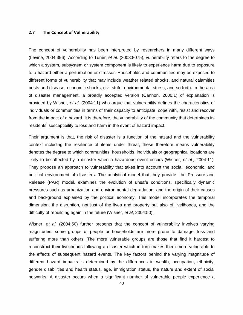
40
2.7 The Concept of Vulnerability
The concept of vulnerability has been interpreted by researchers in many different ways
(Levine, 2004:396). According to Tuner, et al. (2003:8075), vulnerability refers to the degree to
which a system, subsystem or system component is likely to experience harm due to exposure
to a hazard either a perturbation or stressor. Households and communities may be exposed to
different forms of vulnerability that may include weather related shocks, and natural calamities
pests and disease, economic shocks, civil strife, environmental stress, and so forth. In the area
of disaster management, a broadly accepted version (Cannon, 2000:1) of explanation is
provided by Wisner, et al. (2004:11) who argue that vulnerability defines the characteristics of
individuals or communities in terms of their capacity to anticipate, cope with, resist and recover
from the impact of a hazard. It is therefore, the vulnerability of the community that determines its
residents‘ susceptibility to loss and harm in the event of hazard impact.
Their argument is that, the risk of disaster is a function of the hazard and the vulnerability
context including the resilience of items under threat, these therefore means vulnerability
denotes the degree to which communities, households, individuals or geographical locations are
likely to be affected by a disaster when a hazardous event occurs (Wisner, et al., 2004:11).
They propose an approach to vulnerability that takes into account the social, economic, and
political environment of disasters. The analytical model that they provide, the Pressure and
Release (PAR) model, examines the evolution of unsafe conditions, specifically dynamic
pressures such as urbanization and environmental degradation, and the origin of their causes
and background explained by the political economy. This model incorporates the temporal
dimension, the disruption, not just of the lives and property but also of livelihoods, and the
difficulty of rebuilding again in the future (Wisner, et al, 2004:50).
Wisner, et al. (2004:50) further presents that the concept of vulnerability involves varying
magnitudes; some groups of people or households are more prone to damage, loss and
suffering more than others. The more vulnerable groups are those that find it hardest to
reconstruct their livelihoods following a disaster which in turn makes them more vulnerable to
the effects of subsequent hazard events. The key factors behind the varying magnitude of
different hazard impacts is determined by the differences in wealth, occupation, ethnicity,
gender disabilities and health status, age, immigration status, the nature and extent of social
networks. A disaster occurs when a significant number of vulnerable people experience a

41
hazard and suffer severe damage or disruption of their livelihood system in such a way that
recovery is unlikely without external assistance (Wisner, et al., 2004:55).
2.8 Vulnerability Factors
Vulnerability relates to the potential and future jeopardy with the implication or likelihood that
some kind of crisis may occur that will damage one‘s health, life or the property and resources
on which health and life depends (Tanislas, et al., 2009:133; Anderson, et al., 2011:597).
Communities living in hazard prone areas may be made susceptible to negative impacts of the
hazards by conditions determined by physical factors, weak social organizations, limited
economic opportunities, political processes and other factors within the local environment
(Economic Capacity Building, 2006:16). According to Cannon (2000:8), vulnerability is critically
linked to the likely severity of a given hazard impacting on people‘s livelihoods, and this is
primarily determined by the social, physical, economic, environmental and political factors,
which increase the susceptibility of a community to the impact of hazards (UN-ISDR, 2004:24).
These factors determine the level of resilience of people‘s livelihoods and ability to prepare and
withstand hazards. The same factors, as McEntire (2011:299) observes, are part of daily life
and are relevant to the ability of individuals, groups or communities to withstand unforeseen
circumstances like natural hazards. Disasters are a result of hazards impacting on vulnerable
conditions of people and their livelihoods. Therefore if people can be made less vulnerable then
a hazard may still occur, but not produce a disaster (Wisner, et al., 2004:55). This apparently
indicates that reducing disaster is possible not only by modifying the hazard conditions, but also
by reducing vulnerabilities. The basic determinants of vulnerability are: -
2.8.1 Social vulnerability
Social vulnerability is a multidimensional concept that can be used to identify those
characteristics and experiences of communities and individuals that enable them to respond to
and recover from hazards (Levine, 2004:396). According to Wisner, et al, (2004:22), social
vulnerability relates to the characteristics identifiable with persons or the groups that lack the
capacity to anticipate, cope with, resist and recover from the impact of a hazard. Such a
vulnerable population segment, according to CDRSS (2006:73), occupy hazard prone zones,
live and work in less hazard resistant structures within those zones, have lower rates of pre-
impact intervention such as mitigation, emergency preparedness and recovery. They have lower

42
rates of post impact emergency and disaster recovery response. Therefore as Lindell and Prater
(2003:176) observes, they are more likely to experience casualties, property damage,
psychological, demographic, economic or political impacts as direct, indirect or informational
effects (CDRSS:2006:73).
Although Cutter, et al. (2003:243) agrees that social vulnerability is most often portrayed using
the individual characteristics of people such as age, race, health, income, type of dwelling unit
and employment status, Wisner, et al. (2004:11) and Mallick, et al. (2011:228), further point out
that social vulnerability is partially the product of social inequalities, which includes those social
factors that influence or determine the susceptibility of various groups to harm and that also
govern their ability to respond. It also includes place inequalities, that is, the characteristics of
communities and the built environment, such as the level of urbanization, growth rates, and
economic vitality, which add to the social vulnerability of places (Cutter, et al., and 2003:243).
The social science community, however, agrees that some of the major factors that influence
social vulnerability to hazards include: lack of access to resources such as information,
knowledge, and technology; limited access to political power and representation; social capital,
including social networks and connections; beliefs and customs; building stock and age; frail
and physically limited individuals; and type and density of infrastructure and lifelines (Putnam,
1995:66; Tierney, et al., 2001; Cutter, 2003:244; Wisner, et al., 2004:22). Other characteristics
identify special needs populations that lack the normal social safety nets necessary in disaster
recovery, such as the physically or mentally challenged, immigrants, the homeless, transients,
and seasonal tourists. The quality of human settlements (housing type and construction,
infrastructure, and lifelines) and the built environment are also important in understanding social
vulnerability, especially as these characteristics influence potential economic losses, injuries,
and fatalities from natural hazards.
Social factors are linked to the level of wellbeing of individuals, households or communities. It
considers aspects such as the level of education and literacy, peace and security, access the
basic human rights, systems of governance, social equity, positive traditional values, knowledge
structures, customs and ideological beliefs and overall organizational system (Wisner, et al.,
2004:56; Philo, 2005:442). Lack of awareness and access to information can increase levels of
vulnerability (Economic Capacity Building, 2006:18). Disasters can happen because vulnerable
people did not know how to heed to warnings, get out of harm or proactive measures.

43
Some groups of people are more vulnerable than others; the more vulnerable categories include
those less privileged in class and cast structures, ethnic minorities, the very old and other
disadvantaged marginalised segments of the population. Women, because of their role in the
house are more vulnerable in times of disaster (Wisner, et al., 2004:11).
The social factors of vulnerability may be characterised by increased criminal activity, higher
incidence of HIV/AIDS, higher rates of children dropping out of school, declining age of prison
population, declining public health, deteriorating public infrastructure and migration of skilled
professionals (Wisner, et al., 2004:15; Paul, 2005:372,). All this could be symptoms of negative
social processes which result in increased social vulnerability.
2.8.2 Physical vulnerability
Physical factors encompass the aspects of location and susceptibilities of the built environment.
Physical vulnerability is the susceptibility of individuals, households and communities to the
physical environment in which they find themselves (Kynia, et al., 2008:4). It relates to aspects
such as access to suitable land, land use planning, housing design, building standards,
materials used for building houses, accessibility to emergency services. It also entails remotely
located settlements, lack of access to service infrastructure and information (Wisner, et al.,
2004:56; McEntire et al., 2010:58). Physical vulnerability therefore implies exposure to hazards,
living in harmful ways or being in the wrong place at the wrong time.
2.8.3 Economic vulnerability
The economic status of nations, communities, households and individuals greatly influence their
level of vulnerability. This relates proportionately to higher losses in case of a disaster and lower
capacity to recover (Anderson, et al., 2011:596). The poor are more vulnerable than
economically better off sectors of the society (Benson & Clay, 2004:5).
The economic factors of vulnerability include levels of reserves, debt, and degree of access to
credit and loans as well as insurance. Equally, inadequate access to critical and basic social
economic infrastructure such as communication networks, utilities and supplies, and
transportation facilities increase people‘s exposure to risk (Wisner, et al., and 2004:55). Lack of
access to basic services such as water, forces people to use unsafe sources for cooking and
drinking placing them at risk of epidemics and disease. Alternatively, the absence of electricity
or other sources of power will force people to cut down trees for firewood which in turn lead to

44
environmental degradation hence increasing exposure to flooding and other hazards
(Marulanda, et al., 2010:553).
Economic status has influence on people‘s ability to cope and recover from adverse effects. The
rich section of the population may survive the impact of a hazard without suffering any adverse
effects or are able to recover quickly (Wisner, et al., 2004:55). The poor on the other hand, are
forced to build temporarily in crowded, unsafe dwellings in dangerous locations. Vulnerability is
not poverty, but the poor tend to be more vulnerable (Galli & Guzzetti, 2007:650; Kynia, et al.,
2008:33).
2.8.4 Environmental vulnerability
Ecological factors that influence many disasters are either caused or aggravated by
environmental degradation. The creation of drought conditions, for example is a natural
phenomenon, but this may be exacerbated by poor cropping patterns, overgrazing, stripping of
top soil, poor conservation methods, and depletion of both surface and subsurface water
supplies and unchecked urbanization (Nathan, 2008:340, Eeckhaut, et al., 2010:348). The key
aspects of environmental vulnerability include the extent of natural resource depletion, state of
resource degradation, loss of resilience of the ecological system, loss of biodiversity, exposure
to toxic and hazardous pollutants (Wisner, et al., 2004:56).
2.8.5 Political vulnerability
Political factors entail a set of deep rooted social economic elements which include denial of
human rights, lack of access to power structures, education and employment opportunities, land
tenure system, resources, basic service and information (Wisner, et al., 2004:55). All these
create and maintain extreme levels of susceptibility to the impact of hazards.
2.9 Conceptual Frameworks of Vulnerability
Vulnerability has been defined by different scholars and researchers to encompass different
concepts and methods of measurement (Birkmann, 2006:11). These different approaches
according to Bogardi and Birkmann (2004:76), show that it is not clear what vulnerability stands
for, resulting in various analytical concepts and models that attempt to systemise it. The
different concepts and models are essential to the development of methods for measuring and
identifying relevant indicators of vulnerability (Downing, 2004:19). Following are different

45
conceptual frameworks such as the PAR by Wisner, double structure of vulnerability by Bohle,
the livelihood framework and the UN-EHS frameworks.
2.9.1 The Pressure and Release (PAR) Model
The pressure and release (PAR) model views disaster as the intersection of two major forces,
that is those generating vulnerability on the one hand and the natural hazard event on the other.
The PAR model approach underlines how disasters occur when natural hazards affect
vulnerable people (Wisner, et al., 2004:49). The conceptual framework stresses the fact that
vulnerability and the development of a potential disaster can be viewed as a process involving
increasing pressure on the one hand, and the opportunities to relieve the pressure on the other.
The approach is based on the commonly used equation:
Risk = Hazard x Vulnerability
This framework defines vulnerability within three progressive levels that is, the root causes,
dynamic pressures and unsafe conditions (Figure 9). The root causes can be, for instance,
economic, demographic and political processes, which determine the access to and distribution
of power and a range of resources. These root causes are also closely linked with the question
of good governance, such as the nature of the control exercised by the police and military and
the distribution of power in a society (Wisner, et al., 2004:50). The dynamic pressure on the
other hand encompasses all processes and activities that transform and channel the effects of
root causes into unsafe conditions; such may include epidemic diseases, rapid urbanisation and
violent conflicts (Wisner, et al., 2004:54). The dynamic pressure, however, should not be
considered as negative pressure per se (Wisner, et al., 2004:50). Root causes finally lead to
unsafe conditions, which are a third column of the PAR model approach. Unsafe conditions are
specific forms in which human vulnerability is revealed and expressed in a temporal and spatial
dimension. These conditions may include lack of effective protection against diseases, living in
hazardous locations, or having entitlements that are prone to rapid and severe disruption
(Wisner, et al., 2004:52).,They further point out that unsafe conditions are dependent upon the
initial level of well being and how these level varies between regions, micro-regions, households
and individuals (Wisner, et al, 2004:55).
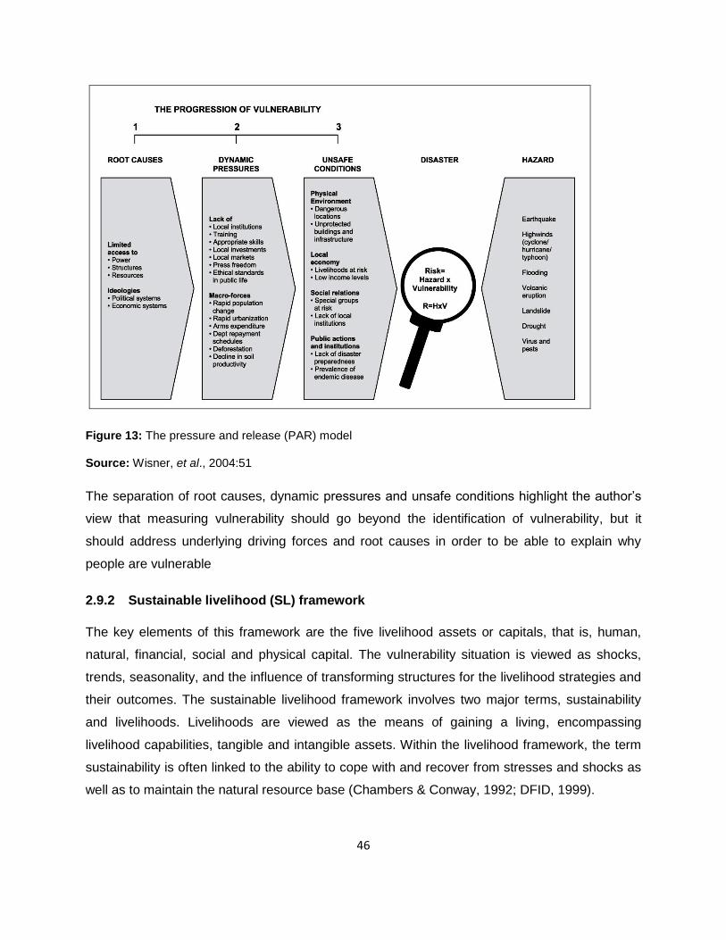
46
Figure 13: The pressure and release (PAR) model
Source: Wisner, et al., 2004:51
The separation of root causes, dynamic pressures and unsafe conditions highlight the author‘s
view that measuring vulnerability should go beyond the identification of vulnerability, but it
should address underlying driving forces and root causes in order to be able to explain why
people are vulnerable
2.9.2 Sustainable livelihood (SL) framework
The key elements of this framework are the five livelihood assets or capitals, that is, human,
natural, financial, social and physical capital. The vulnerability situation is viewed as shocks,
trends, seasonality, and the influence of transforming structures for the livelihood strategies and
their outcomes. The sustainable livelihood framework involves two major terms, sustainability
and livelihoods. Livelihoods are viewed as the means of gaining a living, encompassing
livelihood capabilities, tangible and intangible assets. Within the livelihood framework, the term
sustainability is often linked to the ability to cope with and recover from stresses and shocks as
well as to maintain the natural resource base (Chambers & Conway, 1992; DFID, 1999).

47
The framework (Figure 10) lays emphasis on the transforming structures in the governmental
system or private sector and respective processes such as laws and culture that influence the
vulnerability context, and determine both the access to, and major influences on livelihood
assets of people. The approach underlines the necessity of empowering local marginalized
groups in order to reduce vulnerability effectively (DFID, 1999; Schmidt, 2005). A central
objective of the framework is to provide a method that views people and communities on the
basis of their daily needs, instead of implementing ready-made or general interventions and
solutions, without considering the various capabilities that the poor people may propose (De
Haan & Zoomers, 2005:28).
The framework links with the various categories used in the disaster risk community such as
hazard, exposed and at risk elements, driving forces or root causes, likely outcomes and
responses. The various shocks comprise hazard components while the five livelihood assets
could represent elements that are exposed and susceptible. The transforming structures and
processes in other frameworks are seen as the root causes, dynamic pressures or driving
forces as in the case with the PAR model. The livelihood strategies and outcomes can be
viewed as a mixture of intervention and response elements. However, the understanding of
vulnerability in the sustainable livelihood approach is very broad, also encompassing the hazard
sphere (Baas, et al., 2008:9).
The sustainable livelihood framework can be used to provide an insight and analysis to identify
which type of households are likely to be particularly vulnerable to the impact of hazards. This
framework is developed based on the analysis of the interrelationship between shocks,
vulnerabilities, households‘ bundles of assets and coping mechanisms. The framework puts
households and their livelihoods at the centre of analysis assuming that they are contentiously
influenced by potential threats of shocks and disaster (Baas, et al., 2008:9).
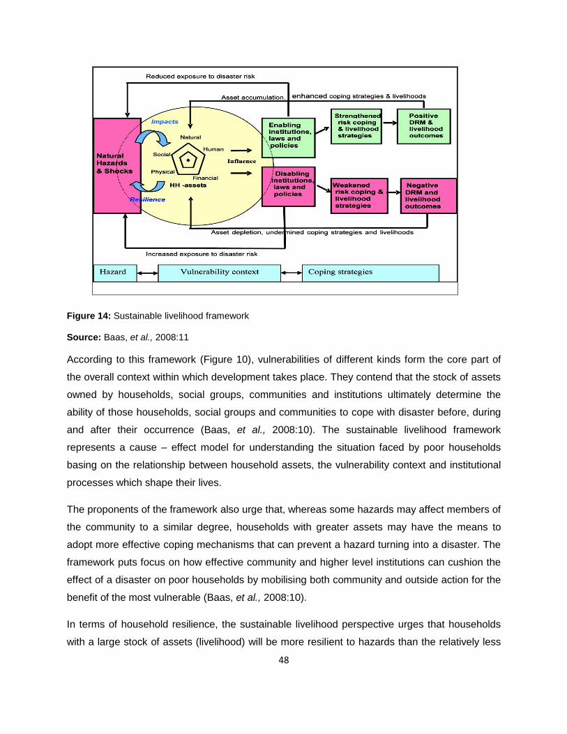
48
Figure 14: Sustainable livelihood framework
Source: Baas, et al., 2008:11
According to this framework (Figure 10), vulnerabilities of different kinds form the core part of
the overall context within which development takes place. They contend that the stock of assets
owned by households, social groups, communities and institutions ultimately determine the
ability of those households, social groups and communities to cope with disaster before, during
and after their occurrence (Baas, et al., 2008:10). The sustainable livelihood framework
represents a cause – effect model for understanding the situation faced by poor households
basing on the relationship between household assets, the vulnerability context and institutional
processes which shape their lives.
The proponents of the framework also urge that, whereas some hazards may affect members of
the community to a similar degree, households with greater assets may have the means to
adopt more effective coping mechanisms that can prevent a hazard turning into a disaster. The
framework puts focus on how effective community and higher level institutions can cushion the
effect of a disaster on poor households by mobilising both community and outside action for the
benefit of the most vulnerable (Baas, et al., 2008:10).
In terms of household resilience, the sustainable livelihood perspective urges that households
with a large stock of assets (livelihood) will be more resilient to hazards than the relatively less

49
asset households. The stock of assets could be drawn by households in the form of reserves to
purchase food, restock or to enable educated households to migrate temporarily for
employment in other areas (Baas, et al., 2008:10). Although resilience is not the central concept
within the framework, resilient individuals or communities could be considered to be those with a
sustainable livelihood (Fitzgerald & Fitzgerald, 2005:16).
2.9.3 The BBC Framework
The term ‗‗BBC‘‘ is connected to the conceptual work done by Bogardi and Birkmann (2004) and
Cardona (2001), which provides a basis for this framework. It grew from three different
discussions seeking to link vulnerability, human security and sustainable development (Bogardi
& Birkmann 2004); develop a holistic approach to disaster risk assessment (Cardona, 2001);
and expand the debate on developing causal frameworks for measuring environmental
degradation in the context of sustainable development.
According to this framework, various vulnerabilities are addressed on the basis of social,
economic and environmental context. The framework stresses that vulnerability analysis goes
beyond the estimation of the deficiencies and the assessment of the disasters in the past. It
emphasises the necessity to view vulnerability within a processes focusing simultaneously on
vulnerability, coping capacities and potential intervention tools to reduce vulnerabilities. It views
vulnerability in terms of the susceptibility and the degree of exposure of elements at risk as well
as their coping mechanisms (Birkmann, 2006:1).

50
Figure 15: The BBC conceptual framework.
Source: Birkmann 2004:35
The BBC framework through the linkages between sustainable development and vulnerability
underlines the necessity to give due consideration to the environment on which human
conditions depend. The concept promotes a problem-solving perspective by analysing possible
losses and deficiencies of the various elements at risk, the coping mechanisms and the
potential interventions measures. The development of vulnerability indicators and the
assessment of vulnerability should address both susceptibility and exposure of different
elements at risk on the basis of social, economic and environmental spheres. Besides it should
also identify and assess coping capacities and the potential intervention tools (Birkmann,
2004:2).
2.9.4 The access to resources and coping model
The access model deals with the amount of access that people have to the capabilities, assets
and livelihood opportunities that will enable them to reduce their vulnerabilities, and avoid

51
disasters (Wisner, et al., 2004:88). The framework puts focus on the way unsafe conditions
arise in relation to the economic and political processes that allocate assets, income and other
resources in the society. It explains the relationship between natural events and the social
processes that generate unsafe conditions. The model aids in explaining the complex and
varied sets of social and environmental events together with the long processes associated with
a disaster (Wisner, et al, 2004:88). It points out that there are generally shared characteristics in
the way vulnerability is generated, how the trigger events and the unfolding of disaster have its
impact. At the micro level it explains the establishment and trajectory of vulnerability and its
variations between individuals and households. It deals with the impact of a disaster as it
unfolds, the role and agency of people involved, how they are impacted, how they cope,
develop recovery strategies, and interact with other actors (Wisner, et al., 2004:88).
Figure 16: The Access to resources and coping model
Source: Wisner, et al., 2004:89
The access model involves the ability of an individual, family, group or a community to use
available resources to secure livelihood in normal pre-disaster times and their ability to adapt to

52
new and threatening situations. At the household level, each individual has an initial state of
well-being defined by physical abilities to withstand shocks, prolonged periods of stress and
deprivation specific to a particular disaster of hazard. The access to resources may include
land, livestock, reserves of food, specialised knowledge and skills, which can be used to avert
the impact the hazards (Wisner, et al., 2004:94).
2.9.5 Bohle’s conceptual framework for vulnerability analysis
According to Bohle (2001:118), vulnerability is seen as having an external and an internal side.
The internal side, that is, coping, relates to the capacity to anticipate, cope with, resist and
recover from the impact of a hazard, while the external side involves exposure to risks and
shocks. In social sciences the distinction between the exposure to external threats and the
ability to cope with them is often used to underline the double structure of vulnerability (Van
Dillen, 2004). Based on the social geography perspective and the intensive famine research
carried out by Bohle (2001:119), the double structure model underlines the fact that vulnerability
is a result of interaction between exposure to external stressors and the coping capacity of the
affected household, group or society. The framework defines and identifies vulnerability as a
potentially detrimental social response to external events and changes such as environmental
change. The Bohle‘s conceptual framework (Figure 13) describes exposure to hazards and
shocks as a key component of vulnerability itself.
Viewed in this way, the term exposure goes beyond mere spatial exposure; it also
encompasses features related to the entitlement theory and human ecology perspective. Within
the debate of social vulnerability the term exposure also deals with social and institutional
features, meaning processes that increase defencelessness and lead to greater danger, such
as exclusion from social networks. These alter the exposure of a person or a household to risk
(Cannon, et al., 2003).

53
Figure 17: Bohle‘s conceptual framework for vulnerability analysis.
Source: Bohle, 2001.
However, the conceptual framework of the double structure indicates that vulnerability cannot
adequately be characterised without simultaneously considering coping and response capacity,
defined here as the internal side of vulnerability.
2.9.6 The International Strategy for Disaster Reduction (ISDR) framework for disaster
risk reduction
According to the UN/ISDR framework, vulnerability is viewed as a key factor determining risk.
They argue that vulnerability can be classified into social, economic, physical and environmental
components (see Figure 14). The vulnerability assessment process is understood as a tool and
a requirement for effective risk assessment (UN/ISDR, 2004:14–15). Although the framework

54
provides an important overview of different phases to be taken into account in disaster risk
reduction, such as vulnerability analysis, hazard analysis, risk assessment, early warning and
response, it does not indicate how reducing vulnerability can also reduce risk. It only places
vulnerability outside the risk response and preparedness framework, making it difficult to
understand the necessity of reducing risk through vulnerability reduction and hazard mitigation.
According to this conceptual framework risk and vulnerability cannot be reduced directly
(Birkmann, 2006). The arrows from vulnerability and hazards only point out into the direction of
the risk analysis while the opportunity to reduce the vulnerabilities themselves is not explicitly
shown. The framework underlines the fact that early warning, preparedness and response could
reduce the disaster impact, even though a link between the risk factors and the application of
risk reduction measures is not included. Moreover, the conceptual framework does not give an
answer as to whether exposure should be seen as a feature of the hazard or of the
vulnerabilities.
On the UN/ISDR report, Living with Risk (UN/ISDR, 2004:16), physical vulnerability is seen as
the susceptibility of location. This may be interpreted as a sign that physical vulnerability
encompasses spatial exposure (UN/ISDR, 2004:42). The report further differentiates between
coping capacity and capacity. Capacity is understood as all the strengths and resources
available within a community, society or organization that can reduce risk, while coping capacity
is the way in which people or organizations use available resources and abilities to face adverse
consequences of a disaster (UN/ISDR 2004:16). This indicates that there is a need for one to
consider the fact that potentially available capacities and applied capacities are different with
regard to disaster risk reduction.
Additionally, the UN/ISDR conceptual framework places vulnerability and the disaster risk
reduction elements within a framework called the ‗‗sustainable development context‘‘ (Figure
14). This is meant to underline the necessity of linking risk reduction and sustainable
development, which means risk reduction strategies, should promote sustainable development
by making the best use of connections among social, economic and environmental goals to
reduce risk (UN/ISDR, 2004:18). Birkmann (2006), however, points out that although it is
important to link risk reduction with sustainable development, the perception that risk reduction
is similar to and compatible with sustainable development is inadequate. In practice,
vulnerability reduction and sustainable development are confronted with deeply rooted social,

55
economic and environmental conflicts, which cannot be wished away through a simple
balancing exercise (Birkmann, 2006).
Figure 18: The International Strategy for Disaster Reduction (ISDR) framework for disaster risk reduction.
Source: UN/ISDR, 2002:23.
2.9.7 The onion framework
This was developed by the UNU-EHS. The onion framework defines vulnerability with regard to
different hazard impacts in relation to the economic and social spheres. The impact of a disaster
and the resultant vulnerability are illustrated using the example of floods. The framework
provides a distinction between a reality axis and an opportunity axis. The reality axis shows that

56
a flood event could affect the economic sphere and cause flood damage, while if the impact of
the flood caused huge additional disruption in the social sphere, a disaster would occur (Figure
15). The model shows that, economic assets can be replaced, but the disruption of the inner
social sphere of a society would result in to long term injuries and losses, which in this model
are primarily associated with vulnerability. Different capacities exist within the centre of the
social sphere (C1–C3), which means that whether a flood event becomes a disaster or not
depends almost as much on the preparedness and coping capacity of the affected society other
than on the nature of the flood event itself (Bogardi & Birkmann, 2004:76). While C1 shows the
fact that although the social sphere is affected, there still exist adequate coping capacities. An
impact of the flood event on the inner circle of the social sphere C3, however, would imply that
social capacities are totally inadequate to deal with the flood event, thus leading to the
occurrence of a disaster (Bogardi & Birkmann, 2004:75).
The onion vulnerability framework (Figure 15) relates the terms, risk and vulnerability, to
potential losses and damages caused in the three different spheres. The model emphasizes
that vulnerability deals with different loss categories, such as economic and social losses. This
means it stresses the fact that if a community or a person‘s losses go beyond economic losses,
for example extending to loss of confidence and trust, the flood event has reached the intangible
assets. This implies a serious disruption of the functioning of the society to the point that
vulnerability becomes evident.
According to this framework, the more comprehensive concept of social vulnerability should
incorporate the monetary dimension that is the likelihood of economic harm as well as
intangibles like confidence, trust and fear as potential consequences of the flood. Furthermore,
the onion framework shows potential response activities related to the different spheres. Finally,
one has to remark that the onion framework does not account for environmental vulnerability. It
defines the environment primarily as the event sphere. The aspect of exposure is also not
specifically incorporated (Birkmann, 2006).

57
Figure 19: The onion vulnerability framework.
Source: Bogardi/Birkmann, 2004:78.
2.9.8 Vulnerability in the global environmental change community
This conceptual framework was developed by Turner, et al. (2003:8077), and is considered as
being a representative of the global environmental change community. Their definition and
analytical framework of vulnerability includes exposure, sensitivity and resilience. According to
this model, vulnerability is viewed in the context of a joint human environmental system (Turner,
et al., 2003:8075; Kasperson, 2005:14). This conceptual framework defines exposure, coping
response, impact response and adaptation response explicitly as parts of vulnerability (Figure
16). The framework also takes into account the interaction of the multiple interacting
perturbations, stressors and stresses (Turner, et al., 2003:8075). This framework further
examines vulnerability within the broader and closely linked human environment context
(Turner, et al., 2003:8076; Kasperson, 2005:14) and takes into account the concept of

58
adaptation, which is seen as an element that increases resilience. Birkmann (2006), however,
points out that the model leaves out some questions unanswered such as whether the
distinction between drivers and consequences in the feedback-loop system is appropriate.
Figure 20: Vulnerability in the global environmental change community framework.
Source: Turner et al., 2003:8076.
2.9.9 A holistic approach to risk and vulnerability assessment
The conceptual framework for a holistic approach to evaluating disaster risk is attributed to the
work of Cardona and his developments with Barbat in 2000. In their first concept, vulnerability is
seen to consist of exposed elements that take into account several aspects of vulnerability
characterized by three vulnerability factors which include:
1. Physical exposure and susceptibility, which is designated as hard risk
and viewed as being hazard dependent.
2. Fragility of the socio-economic system, which is viewed as soft risk and
being non hazard dependent.
3. Lack of resilience to cope and recover, which is also defined as soft risk
and being non hazard dependent (Cardona, et al., 2003).

59
According to this framework vulnerability conditions depend on the exposure and susceptibility
of physical elements in hazard-prone areas on the one hand, and on the other, the socio-
economic fragility as well as on the lack of social resilience and abilities to cope. These factors
provide a measure of the direct as well as indirect and intangible impacts of hazard events. The
framework emphasizes the fact that indicators should measure vulnerability from a
comprehensive and multidisciplinary perspective. They should capture conditions for the direct
physical impacts that is, exposure and susceptibility; as well as for indirect and at times
intangible impacts, socio-economic fragility and lack of resilience of potential hazard events.
Therefore the approach defines exposure and susceptibility as necessary conditions for the
existence of physical risk (hard risk). The likelihood of experiencing negative impacts, as a
result of the socio-economic fragilities and inability to cope adequately are also vulnerability
conditions, which are understood as soft risk (Barkmann, 2006).
This framework suggests a broader understanding of vulnerability, encompassing exposure,
susceptibility and lack of resilience. The consequences of the interaction of the hazardous
events and vulnerabilities are defined as risks from which a feedback loop starts: it
encompasses a control and an actuation system that represent risk management organization,
corrective and prospective interventions. The feedback loop starts after the risk has become
evident (Cardona, et al., 2003).

60
Figure 21: Theoretical framework and model for holistic approach to disaster risk assessment and
management.
Source: Cardona & Barbat, 2000.
2.9 Resilience to Hazards
The concept of resilience has been widely used across many disciplines in the social and
biomedical sciences (Almedom, 2008:5). Originally developed as an ecological concept (Holling,
1973:174), resilience is being used increasingly in the field of human – environment
interactions, including disaster management and vulnerability reduction of natural hazards
(López-Marrero & Tschakert, 2011:229). Generally, resilience implies both the ability to adjust to
normal or anticipated levels of stress and to adapt to sudden shocks and extra ordinary
demands (Galadon, et al., 2008:21). Within the context of natural hazards, resilience
emphasizes the multiple ways a system can respond to hazard occurrence, including its ability
to absorb hazard impacts, to learn from, adapt to and recover from them, and to reorganize after
impacts (López-Marrero & Tschakert, 2011:229). In other words, a resilient system is able to
absorb hazard impacts without changing its fundamental functions, at the same time, it is able to
renew, reorganize and adapt when hazard impacts are significant. Renschler, et al. (2010:1),
note that hazard resilience covers both pre-event measures that seek to prevent hazards

61
related damage and losses while post event strategies are designed to cope with and minimise
disaster impacts.
According to Holling (1973:17), resilience determines the persistence of relationships within a
system, and is a measure of the ability of these systems to absorb change of state variable,
driving variables, and parameters, and still persist. He observes that resilience goes beyond
recovery to advocate anticipation and preparedness in the face of natural hazards. Therefore,
linkages and collaborations between community members and emergency managers need to
be more effectively developed. As defined by the UN-ISDR (2002:24), resilience refers to the
capacity of a system, community or society to resist or to change in order that it may obtain an
acceptable level in functioning and structure. Tumwine and Almedom (2008:1) view resilience
as a multi-dimensional construct referring to the capacity of individuals, families, communities,
systems and institutions to anticipate withstand and engage with catastrophic events actively
making meaning with the goal of maintaining normal functioning without fundamental loss of
identity. At an individual level, human resilience is a normal and common response to adversity
while at family and community levels the capacity to anticipate withstand and maintain normal
functioning following a disaster is mediated by right type, timing and level of social support of
which international humanitarian assistance is one form (Almedom, 2008:7).
Disaster resilience according to Bruneau, et al. (2003:18), is the ability of social units such as
organizations and communities to mitigate hazards, contain the effect of disaster and carry
out necessary activities in ways that minimise social disruption while also mitigating the effects
of future disasters. They further urge that, if the critical services and capital of a community are
not resilient in the face of severe economic and natural disturbance, the result will likely be a
disaster and serious impairment of livelihoods (Bruneau, et al., 2003:18).
Resilience to hazards emphasizes building human capacity to improve the anticipation of,
preparation for and mitigation of such hazard (Kaplan, 1999, López-Marrero & Tschakert,
2011:230). Enhancing community resilience has been identified as a central element of disaster
management, risk reduction and efforts to reduce vulnerability (Adger, 2005:349). The main aim
here is to identify ways in which exposed communities can better anticipate, mitigate, prepare
for and cope with the occurrence of present and future hazard events. This means that
resilience encourages managing hazards instead of merely controlling them. Renschler, et al.
(2010:4), remark that disaster resilient communities have a hallmark of strength, flexibility and
the ability to cope with, and overcome extreme challenges. Such communities, they observe,

62
are characterised by reduced failure probability, that is, reduced likelihood of damage and
failure of critical infrastructure systems and components, reduced sequence of failure in terms of
injuries, lives lost, damage, negative economic and social impacts. Resilient communities
equally, have reduced time of recovery, that is, the time required to restore a specific system or
set of systems back to normal or pre-disaster level of functioning (Renschler, et al., 2010:5).
Disaster resilience therefore requires established standard measures to state resilience, define
its dimensions and measure improvements in resilience.
Glandon, et al. (2008:24) in their study on resilience in the post Katrina disaster observed that
resilience is more than just the absence of post traumatic stress disorder (PTSD), but its wide
spread and in the wake of a disaster its widely driven by the instinct of adaptation. They applied
the ―sense of coherence‖ (SOC-13) concept and its corresponding scales to measure resilience
in a post disaster setting. Their findings show that long-term displacement has a deleterious
effect on human resilience, which suggest that home is an important asset in building resilience
with adversity because it is the core of individual, families and community‘s rootedness. They
recognise in their study that grass root organizations that promote coherence play a very
important role in building and promoting community resilience.
According to Chandra, et al. (2011:3), community resilience or the sustained ability of a
community to withstand and recover from adversity has become a key policy issue which is
embraced at federal, state and local levels. They observe that it is increasingly recognised that
resilience is critical to a community‘s ability to reduce long recovery periods after an emergency.
They identified what they have called key components of community resilience that affect both
pre-event vulnerability to disaster and adaptive capacity to recover. These include the physical
and psychological health of the population, social and economic well-being, individual, family
and community knowledge and attributes regarding self resilience and self help; effective risk
communication; level of social integration of government and nongovernmental organizations in
planning, response and recovery; and the social connectedness of community members (Keim,
2008:514).
In their study Chandra, et al. (2011:4) identified eight levers which have been built on the core
components, and these are then expanded into an applied framework for building community
resilience. They include wellness and access which contribute to the development of the social
and economic well-being of a community; education; which can be used to provide effective risk
communication; while engagement and self sufficiency are needed to build social

63
connectedness. Partnership on the other hand helps engage governmental and
nongovernmental organizations, while quality and efficiency are ongoing levers that cut across
all levers and core components of community resilience (Chandra, et al., 2011:4).
Figure 22: Levers and components of community resilience
Source: Chandra, et al., 2011:4
Figure 18 above shows that as activities related to levers strengthen each of the components of
community resilience, the community moves closer to achieving resilience shown in the circle
because developing resilience is an interactive and ongoing process (Chandra, et al., 2011:10).
Based on the work of Folke, et al. (2002:439), on resilience of social-ecological systems, Berkes
(2007:289) points out different elements that support community resilience to hazards. These
elements are interrelated and they include; learning to live in hazardous, changing and
uncertain environments; that is, the process of adaptation. Adaptation according to Smit and
Wandel (2006:285), refers to the actions a system undertakes to better cope with, adjust to or
manage hazards. They further explain that these actions are attained through social memory,
the lessons that have been learned from past disasters, from accumulated experience and
hazard knowledge, and from reorganization after prior disturbance events, which could include
outside assistance.

64
Using all kinds of knowledge for learning and adaption, this reflects the process of social
learning, which is key to enhancing adaptive capacity and hence resilience. They define social
learning in their study as learning to develop common knowledge, awareness and skills by
engaging multiple participants, sharing diverse perspectives, thinking and acting together. This
according to Surjan and Shaw (2009:419), involves identifying existing knowledge for example
what to adapt to, hazard characteristics, tested strategies and management options for different
stakeholders and bringing this knowledge together to allow for the identification of gaps in
information. This also allows for a common understanding of processes that promote social
learning. Social learning therefore involves refining existing knowledge and generating new
knowledge, which can then be used to guide planning for future actions toward hazard
mitigation and preparedness (López-Marrero & Tschakert, 2011:244).
Nurturing diversity and flexibility according to Berkes (2007:289), includes diversifying
components such as knowledge, practices, management options, institutions, stakeholders and
world views, and being flexible in the use of strategies that allow for adapting, preparing,
mitigating and recovering from hazards (Berkes, 2007:289). They argue that diversity and
flexibility of management options increases the opportunities to cope with natural hazards.
While on the other hand, management strategies that rely on only a few options can erode
resilience by constraining the mechanisms for creative adaptive responses (Folke, et al.,
2002:348). According to Adger, et al. (2005), diversity is important as it helps to maintain,
support and encourage social learning and adaptation through the inclusion of different
stakeholders, knowledge and experience. Besides, it provides the starting point for new options
and opportunities needed in the renewal and reorganizing phases of resilience (Adger, et al.,
2005).
Creating opportunities for self-organization with emphasis put on to build and enhance networks
both horizontal and vertical, partnerships and collaborations (Berkes, 2007:290). Buckle, et al.
(2000) stresses that knowledge sharing, diverse experiences, skills and resources as well as
common goals are all crucial elements that allow systems to reorganize, particularly after
hazard impacts. These various factors according to Allen (2006), can be translated into
strategies and projects that aim at making systems better prepared to face future natural
hazards, and also help to speed up their recovery after hazard occurrence. The social capital
including bonds of trust, reciprocal relationships and collective actions in this case is a key
source of resilience upon which partnerships and collaboration depend (Adger, et al., 2005).

65
Networks, partnerships and collaborations of stakeholders and institutions operating at different
levels also promote social learning, foster diversity and create opportunities for recovery,
renewal and reorganization (López-Marrero & Tschakert, 2011). Self organization according to
the authors can occur within the system or it can be promoted by external components and it
involves flexible decision making and management during times of crisis.
2.10 Conceptual Frameworks for Resilience
2.10.1 The MCEER framework
According to the MCEER framework (Figure 19), developed by Bruneau, et al. (2003:19),
resilience to hazards can be expressed on the basis of the time varying measure of the quality
of the community infrastructure. This framework advocates that the quality of the infrastructure
can range from 0% to 100% where 100% means no degradation in the service, and 0% means
no service is available.
Figure 23: The MCEER resilience framework
Source: Bruneau, et al., 2003:19.
If the infrastructure is subjected to a hazard at time, t0, it could result in damage on the
infrastructure such that the quality is reduced say from 100% to 50% as shown above. The
argument raised here is that the restoration of the infrastructure is expected to occur over time,
that is, t1, when it is completely repaired and returns to 100%. In this framework, the loss of

66
resilience with respect to exposure to specific hazards can be measured by the size of the
expected degradation in quality over time. The MCEER further defines the resilience of both
physical and social systems based on the following properties:
Robustness; this refers to the ability of the elements, systems and other units of analysis to
withstand a given level of stress without suffering degradation or loss of function.
Redundancy; refers to the extent to which elements, systems or other units of analysis exist that
are substitutable, that is, capable of satisfying functional requirements in the event of
disruption, degradation or loss of function.
Resourcefulness; refers to the capacity to identify problems, establish priorities and mobilise
resources when conditions exist that threaten to disrupt some elements, systems or
other units of analysis.
Resourcefulness; can further be conceptualised as consisting of the ability to apply material and
human resources to meet established priorities and achieve goals.
Rapidity; refers to the capacity to meet priorities and achieve goals in a timely manner in order to
contain losses and avoid future disruptions (Bruneau, et al., 2003:19).
The MCEER‘s framework also includes dimensions of resilience which can be used to help
quantify measures of resilience for various types of physical and organizational systems. These
include:
Technical; the ability of a physical system including interconnected components to perform to
acceptable levels when subject to a disaster,
Organizational; the capacity of organizations especially those managing critical facilities and
disaster related functions to make decisions and take action that contribute to resilience.
Social; these consist of measures specifically designed to lessen the extent to which disaster
stricken communities and governmental jurisdictions suffer negative consequences due
to loss of critical services resulting from disaster (Bruneau, et al., 2003:19).
MCEER framework observes that the performance of technical and organizational systems
impact a community‘s social and economic systems in times of disaster. The loss in electric
power for example as a technical element will negatively affect the way of life of the community

67
(social) and business (economic). Resilience objective of technical and organizational
dimension should result in specific tasks that improve performance in each of these dimensions
thereby lessening the negative impacts to the communities (Bruneau, et al., 2003:19).
2.10.2 Community Resilience Index (CRI)
Renschler, et al. (2010:6) define a resilient community as one that does not experience serious
degradation in critical services when an extreme event occurs and in the event of a degradation
or failure of certain services, recovers to a similar or batter level of service within a reasonable
amount of time. They front the development of an integrated community resilience index that will
enable the development of geospatial and temporal decision support software tools to help
planners and key decision makers and stakeholders to assess and enhance resilience of their
communities. The resilience index requires quantifying the status, exposure and recovery of
physical, economic, social-cultural and ecological capital for a specific target community.
They develop a resilience framework that provides a methodology to assess the recovery of
vegetative biomass after an extreme event, and they use these to derive a computer simulation
model of community disaster resilience. This model makes use of the information on the
expected biomass production as a measure for ecosystem wellness and incorporates it into the
simulation of recovery dynamics of social-economic agents such as households and
businesses, neighbourhoods and communities following a disaster. The result of their study
indicate that the variable nature of the recovery of ecological capital after an extreme event can
potentially impact the recovery of certain business that rely heavily on ecosystem services such
as agriculture, forestry, fisheries and tourism (Renschler, et al., 2010:6).
Mampare and Bouwer (2006:445) undertook a study to indentify resilient and non resilient
middle adolescents in formerly black only, urban schools in South Africa. They urge that
resilience means having a disposition to identify and utilise personal capacities, competencies
(strength) and assets in a specific context when faced with perceived adverse situation. This
implies that the interaction between the individual and the context leads to behaviour that elicits
sustained constructive outcomes that may include continuous learning and flexibly negotiating
the situation. Resilient individuals are considered to have a hardy personality and are likely to
employ adaptive strategies and not maladaptive responses like denial. Such individuals
according to Mampare and Bouwer (2006:445), have been found to be characterised by internal
locus of control with a sense of purpose, challenge, commitment, responsibility and
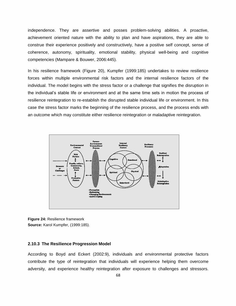
68
independence. They are assertive and posses problem-solving abilities. A proactive,
achievement oriented nature with the ability to plan and have aspirations, they are able to
construe their experience positively and constructively, have a positive self concept, sense of
coherence, autonomy, spirituality, emotional stability, physical well-being and cognitive
competencies (Mampare & Bouwer, 2006:445).
In his resilience framework (Figure 20), Kumpfer (1999:185) undertakes to review resilience
forces within multiple environmental risk factors and the internal resilience factors of the
individual. The model begins with the stress factor or a challenge that signifies the disruption in
the individual‘s stable life or environment and at the same time sets in motion the process of
resilience reintegration to re-establish the disrupted stable individual life or environment. In this
case the stress factor marks the beginning of the resilience process, and the process ends with
an outcome which may constitute either resilience reintegration or maladaptive reintegration.
Figure 24: Resilience framework
Source: Karol Kumpfer, (1999:185).
2.10.3 The Resilience Progression Model
According to Boyd and Eckert (2002:9), individuals and environmental protective factors
contribute the type of reintegration that individuals will experience helping them overcome
adversity, and experience healthy reintegration after exposure to challenges and stressors.
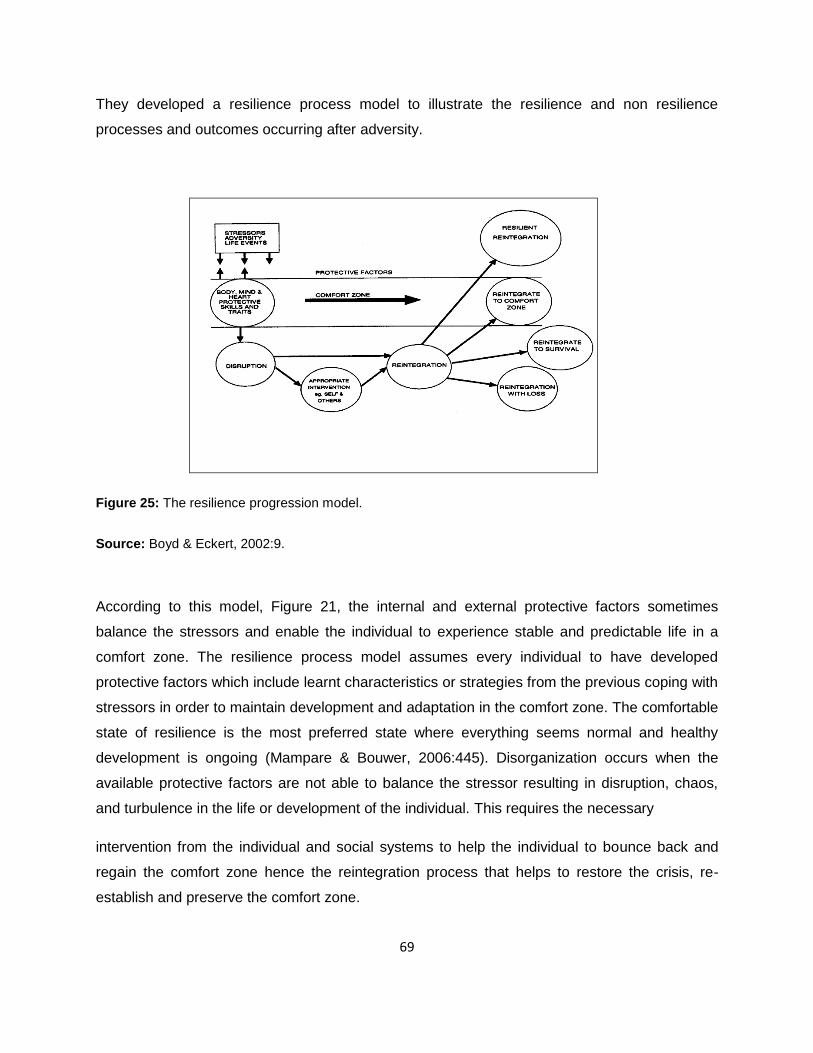
69
They developed a resilience process model to illustrate the resilience and non resilience
processes and outcomes occurring after adversity.
Figure 25: The resilience progression model.
Source: Boyd & Eckert, 2002:9.
According to this model, Figure 21, the internal and external protective factors sometimes
balance the stressors and enable the individual to experience stable and predictable life in a
comfort zone. The resilience process model assumes every individual to have developed
protective factors which include learnt characteristics or strategies from the previous coping with
stressors in order to maintain development and adaptation in the comfort zone. The comfortable
state of resilience is the most preferred state where everything seems normal and healthy
development is ongoing (Mampare & Bouwer, 2006:445). Disorganization occurs when the
available protective factors are not able to balance the stressor resulting in disruption, chaos,
and turbulence in the life or development of the individual. This requires the necessary
intervention from the individual and social systems to help the individual to bounce back and
regain the comfort zone hence the reintegration process that helps to restore the crisis, re-
establish and preserve the comfort zone.

70
Besides the comfort zone reintegration, the other option according to this model is to view
resilience as a state of growth or advancement that surpasses the comfort zone. Boyd and
Eckert (2002:9) explain that at such a point, the individual becomes greater than previously.
Reintegration with loss is a state that is inclined to be dysfunctional with individuals perceiving
themselves as victims of unfortunate circumstances which may be manifest, for example by way
of succumbing to drug or alcohol abuse, suicide attempts and displaying loss of self-worth or the
capacity to cope. Some individuals fail to recover fully from the stressor, and this leads to a life
of emptiness with loss of hope and enthusiasm, assuming negativism and employing unhealthy
and antisocial coping strategies. Such individuals have reintegrated into states of survival and
reintegration with loss (Boyd & Eckert, 2002:9). They are the non-resilient individuals who
require interventions such as care and support, life skill training, pro-social bonding,
opportunities, meaningful participation, clear structures and expectations to help them exit the
below comfort zone. Non resilience can be equated to the downward spiral from which the
individual may never recover.
2.11 The Concept of Coping
The concept of coping reflects the increased recognition of people‘s ability to face climate-
related and other natural hazards (Gaillard, 2010:220). It refers to the resources and assets
people possess to resist, cope with and recover from disaster shocks that they experience
(Davis, et al., 2004). According to Kuban and MacKenzie-Carey (2001), the concept also
encompasses the ability to either use and access needed resources. Therefore it goes beyond
the sole availability of these resources. Meanwhile, Gaillard (2010:220) points out that, coping
capacities are often rooted in resources which are endogenous to the community and depend
on traditional knowledge, indigenous skills, technologies and solidarity networks. The ways in
which capacities are mobilized in times of crisis reflect coping strategies. The United Nations
International Strategy for Disaster Reduction (UNISDR) (2002), on the other hand defines
coping strategies as the manner in which people and organizations use existing resources to
achieve various beneficial ends during unusual, abnormal and adverse conditions of a disaster
phenomenon or process.
Alam (2006:3) observes that coping, adaptation and adjustment are three similar ideas used to
explain how individual and a community react to an exceptional situation as a result of disasters.

71
It entails a set of actions, mechanism, strategy and initiatives that are used by an individual or a
community to view, act or behave towards the situation. Wisner, et al. (2004:113) describe
coping as a manner in which people act within the limits of existing resources and range of
expectations to achieve various ends. This implies that coping is a means by which people or
organizations use available resources and abilities to face adverse consequences that could
lead to a disaster. Coping according to Khandker (2007:172) generally involves managing
resources, both in normal times as well as during crises or adverse conditions.
It is the ability of people, organizations and systems using available skills and resources to face
and manage adverse conditions, emergencies or disasters (UN-ISDR, 2002:24). It involves no
more than managing resources, but usually implies how it is done in unusual, abnormal and
adverse situations (Brahmi & Poumphone, 2002:39). This means, coping includes defence
mechanisms, active ways of solving problems and methods for handling stress. In the face of
adverse circumstances, coping may be seen as a series of adaptive strategies to preserve
needs as high up the hierarchy as possible in the face of threat. The major aim behind the
objective of coping is the survival of the individual in the short term (Wisner, et al., 2004:113).
Cohen and Sebstad, (2005:432) observe that coping mechanisms are adaptive strategies in the
face of adverse circumstances. People collectively or individually often adopt certain actions to
cope with abnormal situations which can be in several forms such as:
1. Physically; by changing the physical environment for example comfortable shelters.
2. Behaviourally and habitually; by way of changing food habits.
3. Physiologically and emotionally; by male for example taking care of children, women
taking role considered as men‘s such as alcoholism and drug abuse.
4. Livelihoods; finding new sources earning, distress selling.
5. Values and dignity; people may change their affiliation, take up new roles or work
generally considered as less dignified, giving legitimacy to action considered as illegal
before the occurrence of disaster.
6. Organizationally; this is associated with groups that play a role in mobilizing for external
assistance (Cohen & Sebstad, 2005:433; Alam, 2006:3).
72
They, however, conclude that the way one copes with hazard situations is very much related to
their culture, history, knowledge system, power dynamics or governance of a particular
geographical of political unit. Wisner, et al. (2004:114) on the other hand, observe that local
coping strategies for managing disasters are often transmitted from generation to generation
within communities and households. This is based on the assumption that disasters follow a
familiar pattern; therefore people's earlier actions are the reasonable guide for similar events.
2.12 Mechanisms for coping with disaster
Disasters have always occurred and have impacted individual lives, communities, societies and
households. This calls for mobilization of resources at various levels to cope with such impact
(Wisner, et al., 2004:115). Douglas (2006:77) observes that when people know an event may
occur in the future because it has happened in the past, they often set up ways of coping.
Coping strategies are a set of measures taken by the communities for obtaining resources in
times of adversity and disaster. According to Brahmi and Poumphone (2002:39), they are based
on experience, social structures, resources and their capabilities to combine them. They are
often transmitted from generation to generation within communities or households and they
depend on the assumption that the event will follow a familiar pattern, and that people‘s action
will be a reasonable guide for similar events (Brahmi & Poumphone, 2002:40; Wisner, et al.,
2004:115). Coping strategies for adverse events, which are perceived to have precedents
consist of actions before, during and after an event (Khandker, 2007:172, 173). Wisner, et al.
(2004:115) identify different types of coping strategies which could be applicable to individuals,
households and communities; these include:
1. Preventative strategies: at the individual and small group level means people making
choices so that they will not be affected by an event, such as avoiding dangerous places
at certain times or choosing safe residential locations.
2. Impact minimising strategies: these are strategies to minimise loss and to facilitate
recovery in the event of a loss. This is generally referred to as ‗mitigation‘ in disaster
literature, but ‗adaptation‘ in climate change literature. Very simply, this should imply
improving access to a minimum level of food, shelter and physical security so that
people will be less vulnerable in case a disaster or climatic event does happen.

73
3. Building up stores of food and saleable assets: storing of food may be more common in
rural areas, but urbanites living in a cash-based economy may use similar strategies
such as keeping items of value that can be sold if needed.
4. Diversifying income sources: in cities this may mean illegal or quasi-legal work, such as
street-hawking, waste recycling, or even looting and pilfering in areas that have been
affected by a disaster. Having more than one, or sometimes several, income earners in
the family also allows for diversification. If families have contributed to savings groups,
this can offer a form of income during hard times.
5. Development of social support networks: this is the ability to call on the resources of
others during difficult times. The social structures that form the basis of community and
family life play a key role in determining the individual and collective levels of
vulnerability (Cutter, et al, 2003:243).
Networks can be within the household, between extended family members living near or afar,
within neighbourhoods, and with wider groups who have a shared identity such as religious,
geographic or commercial. Assistance can come in many forms such as financial help,
emotional support, shelter in time of need, or physical helping of any kind (Dougall, et al.,
2001:225). According to a study by Birkmann, et al., 2006) they report that, when the tsunami hit
the Uited States, it was primarily neighbours (55 per cent), friends (10 per cent) and other family
members and relatives (18 per cent) who helped the affected people before the authorities
could provide aid and rescue support. Dougall et al, (2001:225) points out that social support
networks helps disaster victims to overcome distress and long-term intrusions. They have been
linked consistently with less self-reported distress, lower heart rate and blood pressure, lower
catecholamine levels, better immune functioning, the use of more adaptive coping strategies,
such as problem-focused coping, and less use of maladaptive coping strategies, such as
avoidance.
2.13 Post event coping strategies
Post event coping strategies may include the substitution of lower quality and wild food for more
expensive staples; these can be followed by calling on resources from others that can be
obtained without threatening future security through reciprocal social interactions and avoidance
of usurious interest rates (Wisner, et al., 2004:116). They also argue that other sources of

74
household income apart from the dominant ones may be tapped such as wage labour, petty
commodity production, and sale of easily disposable items that do not undermine future
productive capacity may also be done to cope with the tragedy. They point out that the stress
that requires coping may build up over a longer period of time. This allows for succession of
strategies for adaptation in (Wisner, et al. 2004:116). Households may be force to get loans
from money lenders and sell important assets such as agricultural implements and livestock
when all the preceding strategies have failed to curd the situation. Households may also migrate
to roadsides, towns and possible sources of survival (Wisner, et al., 2004:116).
2.13.1 Culture of coping with hazards
Bankoff, (2007:26) observes that communities that are subjected to different kinds of hazards
and threats develop different cultures of coping. Such changes can be found in their historical
records and may include changes in design and construction of buildings, change in agricultural
systems, constant relocation of settlements and the frequency of migrations. The design of
homes and buildings in the Philippines for example has been greatly influenced by the seismic
and meteorological hazards. The use of simple palm and bamboo huts offer a good example as
they are easily rebuilt when damaged and are less likely to injure people during storm or
earthquake.
2.13.2 Relocating settlements
The survivors of a community may opt to relocate their settlements to safer areas removed from
the perceived source of danger. This is a coping strategy. Following the Katrina hurricane
disaster in the United States of America, many families in the New Orleans who had been
affected left the city and moved temporarily to leave with relatives elsewhere in the country.
Bankoff, (2007:27) also observes that the people of central Luzon in the Philippines abandoned
their beach side settlement in 1756 and moved to a location further inland as a result of
devastating destruction caused by the eruption of Taal volcano in 1754 and the impact of the
floods that had hit the lower part of their town. In 1991, following the eruption of Mount Pinatubo,
the second largest volcanic event of the twentieth century, seven cubic kilometres of pyroclastic
material devastated the surrounding areas causing between 900 to 1000 hazard related deaths
and displacing nearly 1.2 million people as communities were forced to relocate to safer places
(Bankoff, 2007:27). These kinds of migrations and relocations can be regarded as coping
practices to prevent the same set of circumstances from reoccurring.

75
2.13.3 Emotional and psychological adaptation
The frequency and magnitude of hazard exposure may lead the affected communities to identify
various ways of coping emotionally and psychologically. Communities that have been exposed
to hazards have developed expression that help them cope such ―leave it to fate‖. At the same
time expressions of courage, daring and a sense of finely calculated assessment of the odds
coupled with elements faith in the effectiveness of prayer and intercession may be adopted to
define protection (Bankoff, 2007:28). Following the eruption of Mount Pinatubo, many local
people resorted to both Christian prayer and shamanistic rituals to strengthen their village‘s
defence and protect themselves from the flow of larvae. Glandon, et al, (2008:24) on their study
of resilience on post Katrina New Orleans also report that respondents often mentioned the
people, institutions and beliefs that helped them to cope. The most commonly mentioned source
of strength and support were religion, church or faith in God.
2.13.4 Support for one another
Communities that are subjected to hazards tend to respond by way of helping one another,
sharing shelter and food with those who have lost livelihood completely. (Bankoff, 2007:28)
observes that one of the core coping mechanism among the Pilipino people is the practice they
call bayannihan, this is translated to mean ―toiling on another‘s behalf and assuming another‘s
burdens‖. The meaning behind the concept has the connotation of shared identity and common
association expressing the sense of shared community, that is, neighbourhood which
guarantees support for members especially during times of personal travail or common
hardship. In the United States, after the hurricane Katrina storm many affected people
confessed they were relieved when they found out their relatives and friends were safe and they
appreciated having them around to share resources or simply commiserate (Glandon, et al.,
2008:24)
2.13.5 Community mobilization
Is another coping strategy that provides for self generated community action in times of disaster.
In the early days there were formal and informal associations at the local level committed to
individuals and extra-familial welfare (Bankoff, 2007:29). The religious associated functioned
alongside or overlapped the village based mutual aid organizations in which the notion of
reciprocity and assistance were common place. In the late nineteenth and early twentieth
centuries, there were developments of some of these into rural credit associations, farmers

76
organizations and corporative societies, these and other manifestations of civil societies like
Parents Teachers Association (PTA) and unions share much in common with the contemporary
nongovernmental organizations (NGO‘s) (Bankoff, 2007:29).
2.13.6 Personal resources
Where communities are self reliant, they depend on their own resources to deal with hazards
that confront them (Glandon et al., 2008:25), while the most vulnerable especially the poor who
poses little in form of resources tend to mobilise themselves and practice mutual reliance.
Following the 1990 Baguio earthquake disaster, households and neighbourhoods immediately
responded by sharing food, shelter and transport by way of sharing kitchens, providing shelter
to the homeless and pooling available vehicles to facilitate transportation (Bankoff, 2007:29).
2.13.7 Use of social networks
The degree of interdependence, the need for corporation and construction of strong social
networks are important coping mechanisms in communities faced by continual environmental
uncertainty (Glandon et al., 2008:25). During hurricane Katrina disaster in New Orleans USA,
grass root organizations are reported to have played a very important role in building and
promoting coping for the community. They helped the worst affected local communities recover
from the disaster regardless of their individual membership (Glandon et al, 2008:25).
2.14 Coping Strategies for Landslide Hazards
The interaction of the human beings and the natural world exert influence on the natural
environment resulting to persistent hazards or threats and disasters. Although the natural social
sciences depict disasters as abnormal occurrences, hazard prone communities usually come to
accept hazards and disasters as a common phenomenon in life (Bankoff, 2007:26). These has
guides them to develop a number of adaptive strategies to enable cope with disasters. The
coping mechanisms adopted by individuals, households or communities are based on the
assumption that what has happened in the past is likely to repeat itself following a familiar
pattern (Wisner et al., (2004:116).

77
2.15 Conclusion
The chapter has provided an overview of landslide hazards, classification of landslides, causes,
trigger factors and the impact of landslides. The literature also explores the concept of
vulnerability, resilience and coping in relation to landslide hazards. The models that have
developed by different authors to explain these concepts have been examined. The purpose for
this is to provide a basis to explain household vulnerability, resilience and coping with landslide
hazards. In the next chapter the methodology for executing the study is presented.

78
Chapter Three Research Methodology
3.1 Study Design
This chapter describes the techniques that were employed in the course of executing this study
to the point of arriving at conclusions that have been made from the raw data. It describes the
methods used in data collection, tools and sources of data. It explains issues of sample
selection, data management and analysis. The chapter provides a full description of the study
area and also highlights the limitations to the study.
This study employed qualitative design and it applied a cross sectional approach. This was a
better design in conducting an assessment of a phenomenon, and has enabled the researcher
get the real overall picture of what is on the ground. It enabled the researcher to interact with a
cross section of the affected population, opinion leaders in the area, and the humanitarian
agencies involved in emergency activities. The approach incorporates the opinion of the people,
which provides the best design in assessing vulnerabilities, resilience and coping mechanisms
in the area.
3.2 Study Population
The research studied a cross section of households and opinion leaders in Nametsi sub-county,
Bududa district, Bududa County. The households were of interest in this study because they
were the ones directly affected by the landslides hazards and whose livelihood was being
disrupted. The opinion leaders, on the other hand, were considered for the purpose of providing
a balanced assessment on the vulnerability factors, resilience and coping mechanisms in the
disaster prone areas. The opinion leaders constituted the key informants who were interviewed
during data collection.
3.3 Sample Size
The study collected data for a period of fourteen days from a cross section of 261 households
constituted from Bukalasi sub-county in the villages of Nametsi, Kubewo, Namubele, Murwerwe,

79
Maskanu and Tunwasi. The household heads interviewed were selected from the five different
villages. In the selected villages, interviews with key informants consisting of opinion leaders
were conducted. A sample size of 261 was considered adequate enough to provide ample data
that could be used to generate reliable, valid and generalizable results. These would provide
valid inferences representative of the population in Bududa. The sample size was also
considered on the basis that it would produce adequate information to explain significant
relationships, differences or interrelationships in the variables under consideration (Bartlett, et
al., 2001:43).
3.4 Sampling Method
The sub-county of Bukalasi was strategically selected because of its location. The sample
parishes and villages from the two sub-counties were selected on the basis of their strategic
location and having experienced landslide hazards in 2010. The households interviewed in each
village were selected on the basis of purposive sampling technique. This allowed the researcher
to select the most appropriate sample of households to be interviewed. The researcher asked
the previous interviewee to provide details and contact of another potential two to three
households that could be interviewed. A list of those suggested was made and they were
contacted to fix an appointment for interviews. The same method was used in selecting opinion
leaders who were interviewed as key informants.
3.5 Research Tools
The study used structural questionnaires, personal observation and key informant discussions
in the data collection process. The questionnaires for the household interviews were composed
of closed ended questions, a sample attached as Appendix A. The key informants interviewed
were constituted from the local opinion leaders. The key informant interview method was useful
because it provided an opportunity for open expression of opinions and gave the researcher an
opportunity to probe more on the issues being raised during the discussions. The key
informant‘s interview guide is attached as Appendix B. The use of observation techniques
enabled the researcher to gather information on multiple variables in a small population and
geographical area.

80
3.6 Data Collection
The qualitative methods used in data collection comprised household interviews, key Informant
(KI) interviews and observations. A sample of the questionnaire that was used for household
interviews is attached (Appendix A). Qualitative data was collected by way of administering
questionnaires directly to the household heads, and taking notes during both observations and
key informant discussions. The household heads interviewed were selected purposefully.
Interviewees were asked to recommend two to three possible respondents and their contacts;
these were contacted to make appointments for the interviews. Observation checklist was
constructed and systematic observations were made in the villages with the help of a checklist.
They focused on household vulnerability factors, land use, human activities, location of
settlements, landslide resilience and mitigation related activities in the area. Interactive
interviews were held with 25 key informants (KIs) consisting of opinion leaders from the six
villages. The interview guide is attached as Appendix B. These were selected purposefully,
using the local knowledge of the subject and geographical area. The researcher identified some
key informants that were thought would be relevant. They were later asked to recommend two
to three possible respondents and their contacts. The collected data was cleaned to help
identify gaps that were immediately completed and the data captured in the computer on a daily
basis.
3.7 Data Management and Quality Assurance
The data collected was cleaned and coded according to the criteria developed by the
researcher. The coding process was then followed by data capture using Epi Info. The data was
transferred to the statistical package for social sciences (SPSS) for analysis to be performed. To
ensure quality, research assistants were recruited and trained for one day on how to administer
the questionnaires and collect quality qualitative data. They were familiar with the study area
and fluent in the local language (Lumasaba) and English. The questionnaires were pre-tested
and edited where necessary to cover identified gaps. Meetings were also held with research
assistants on a daily basis to counter any challenges that were met during the data collection
process. During data collection, supervision was done continuously, and the researcher himself
was in the field.

81
3.8 Ethical Considerations
In consideration of the research ethics and code of conduct, this study was subjected to the
institutional review by the Uganda National Council for Science and Technology who gave its
due approval (Appendix B). Permission to carry out the study was dully granted by the Office of
the President (Appendix C). Besides, in the process of collecting data, the purpose of the study
was explained to the respondents verbally, and their consent to participate was obtained. The
respondents were informed that participation was voluntary, confidential, without any risk and
that they could choose not to participate or withdraw their participation at any time during the
interview.
3.9 Conclusion
The chapter has described the methodology used in this study. The characteristics of the study
area have been presented to help bring better understanding of the physical environment where
landslides occur. The next chapter presents analysis and findings derived from the data.

82
Chapter Four Presentation of Study Findings
4.1 Introduction
This chapter focuses on analysis and presentation of results of the data gathered from the
household survey carried out in Bududa district, Bududa County, Bukalasi sub-county in the
villages of Tunwatsi, Nametsi, Masakhanu, Murwerwe and Kubehwo. The results presented in
this chapter have been arranged in sections which include; the analysis of social demographic
aspects of the respondents, this includes gender, age groups, duration of stay, educational
attainment, income levels, ownership of housing structure, people‘s awareness of landslide
occurrences, impact of landslides on household, vulnerable groups, perceived causes of
vulnerability; household coping strategies; mechanisms for reducing the impact of landslides;
training on land slide management and mechanisms for managing sudden shocks and stress
caused by landslides. Relationships between variables were tested using cross tabulation
methods.
4.2 Socio-Demographic Characteristics of Households
The total sample comprised of 261 respondents who were household heads. The social
demographic features of households are as shown in (Table 3). The majority of the respondents
were male (71.65%) while females constituted 28.35%. Most of the respondents were aged
between 25 and 39 years (34.87%). The level of education was assessed because it was an
important factor in understanding household vulnerability to disasters. The majority of the
respondents (65.38%) attained only primary education as their highest level with 15.38% having
no schooling at all. 15.00% had secondary level education and only 11 respondents,
represented by 4.23% had attained tertiary level of education. The majority of the households
112; that is 42.91% had between four to six members, 20.77% had between one to three
members, while 93 households, a representative of 36.40% of the total households had seven
or more members.

83
TABLE 3: SOCIO-DEMOGRAPHIC CHARACTERISTICS OF HOUSEHOLDS
Variable Frequency Percentage Cum. Freq (n=261) (%)
Sex of household head
Male 187 71.65 71.65
Female 74 28.35 100.00
Age group of household head
Less or equal to 18 2 0.77 0.77
18 – 24 38 14.56 15.33
25 - 39 91 34.87 50.19
40 – 49 54 20.69 70.88
50 - 59 43 16.48 87.36
60+ 33 12.64 100.00
Education Levels
No formal education 40 15.38 15.38
Primary 170 65.38 80.77
Secondary 39 15.00 95.77
Tertiary 11 4.23 100.00
Household size
1 - 3 54 20.77 20.77
4 - 6 112 42.91 63.68
≥7 95 36.40 100.00
4.2.1 Ownership, type of dwelling and duration of stay
Out of the 261 respondents, nine represented by 3.46% had lived in the area for a duration of
less than one year, while 8.46% and 16.92% of the respondents had lived in the area for a
period of between one to five years and 6 - 15 years respectively. The majority of the
respondents 71.26% had lived in the study area for more than 15 years. The type of dwelling
was important in assessing household vulnerability to landslides and household resilience and
coping. The majority of the households interviewed (68.58%) lived in informal buildings; that is,
grass thatched roof with wood and wattle walls (Figure 26). Of the households, 11.88% lived in
semi formal buildings; that is, wood and wattle walls with iron sheet roof; while 19.62% lived in
formal kinds of buildings. In terms of ownership, only 1.15% lived in rented houses while
98.85% were living in their own houses. The majority of households therefore lived in the type of
houses that make them susceptible to landslides and the impact of high precipitation in the
area.

84
Figure 22: A kind of informal buildings in Bukalasi, Photograph taken during field study.
TABLE 4: OWNERSHIP, TYPE OF DWELLING AND DURATION OF STAY
Variable Frequency Percentage Cum. Freq (n=261) (%)
Ownership of housing structure
Own house 258 98.85 98.85
Rented house 3 1.15 100.00
Type of dwelling
Informal building 179 68.58 68.58
Semi formal 31 11.88 80.46
Formal building 51 19.62 100.00
Duration of stay
Less or equal to 1 year 9 3.46 3.46
1 – 5 years 22 8.46 11.92
6 – 15 years 44 16.92 28.85
≥15 186 71.26 100.00

85
4.2.2 Economic Status of Respondents
The economic status of households is important as a factor in the increased occurrence,
vulnerability and reduced resilience in the face on natural disasters. The majority of household
heads interviewed (56.32%), were self-employed in the informal sector, which included activities
like brewing, charcoal burning and other forms of wage based informal activities like provision of
manual agricultural labour. Others, 35.00% did not have any form of employment, 7.31% were
formally self-employed, that is formal businesses such as shop, while only1.54% had a formal
form of employment, that is, earning a formal monthly income in the form of a salary. The levels
of income were low; the majority of the respondents (69.57%) earned between Uganda Shillings
(UGX) 5,000 – 300,000 per annum (an equivalent of $ 117.64 per annum). 21.92% of
households had an income of more than Uganda Shillings 500,000 (an equivalent of $ 196.07
per annum), while a total of 24 households represented by 9.19% did not have any source of
income (Table 5) below.
TABLE 5: TOTAL ANNUAL HOUSEHOLD INCOME
Variable Frequency Percentage (n=261) (%)
None 24 9.19
5,000 – 10,000 26 10.00
10,001 – 50,000 16 6.15
50,001 – 100,000 43 16.54
100,001 – 300,000 42 16.15
300,001 – 300,001 53 20.38
≥500,001 57 21.92 Total 261 100.00
4.3 Awareness and Impact of the 2010 Landslides
According to the key informants that were interviewed in the field, the occurrence of landslides
in the area took the residents by surprise because it was a natural phenomenon. The majority of
the respondents, 91.51% were aware of the 2010 landslide occurrence, while only 7.75% said
they were not aware. In terms of the effect of landslides, 59.39% of the respondents had been
affected by the landslides, and 40.61% said they had not been affected. A majority of the
households (95.38%) said they did not have any prior warning about the impending threat of

86
landslides, while 4.62% said they had warnings about the threat of landslides as indicated by
Table 6.
TABLE 6: AWARENESS AND IMPACT OF THE 2010 LANDSLIDE
Variable Frequency Percentage Cum. Freq (n=261) (%)
Awareness of the 2010 landslide
Yes 241 91.51 91.51
No 20 7.75 100.00
Affected household
Yes 155 59.39 59.39
No 106 40.61 100.00
Warning about landslide
Yes 12 4.62 4.62
No 248 95.38 100.00
4.3.1 Source of information
Regarding the different media for passing information on landslide threat, 2.68% of the total
respondents said they received information through the area local council (LC) meeting, 3.45%
said they received warnings about landslides by word of mouth while, 0.38% of the total
respondents reported that they had received information by radio and traditional ways. No one
received information by means of television, posters, the internet, news papers (Table 7). That
can be partly explained by the remote location of the area. One key informant explained that
they were susceptible to landslides because they lived in ―no man‘s land‖ which could only be
reached on foot.

87
TABLE 7: SOURCE OF INFORMATION FOR HOUSEHOLDS
Variable Frequency Percentage Cum. Freq (n=261) (100%)
Through television
Yes 0 0.00 0.00
No 261 100.00 100.00
Through radio:
Yes 1 0.38 0.38
No 260 99.62 100.00
Word of mouth
Yes 9 3.45 3.45
No 252 96.55 100.00
Posters put up
Yes 0 0.00 0.00
No 261 100.00 100.00
On internet
Yes 0 0.00 0.00
No 261 100.00 100.00
Newspapers
Yes 0 0.00 0.00
No 261 99.62 100.00
Traditional ways
Yes 1 0.38 0.38
No 260 99.62 100.00
Local council (LC) meetings
Yes 7 2.68 2.68
No 254 97.32 100.00
4.4 Household Vulnerability to Landslides in Bududa
4.4.1 Most affected by landslides in Bududa
The majority of the respondents, 64.62% said that children were the most affected by landslides
followed by the elderly persons, 21.15%. The effect on women was represented by 9.62%,
disabled persons 3.46% while others which included traders and visitors constituted 2.30% of
the total sample interviewed (Table 8). Most key informants interviewed emphasized that
children were greatly affected because they were returning from school and being a rainy day,
they had taken shelter at the nearby health centre which unfortunately got completely buried by
rubbles form the landslides which caught them unawares because it happened suddenly.

88
TABLE 8: MOST AFFECTED HOUSEHOLD MEMBERS
Variable Frequency Percentage Cum. Freq (n=261) (%)
Children
Yes 169 64.62 64.62
No 92 35.38 100.00
Elderly people
Yes 55 21.07 21.07
No 206 78.93 100.00
Disabled persons
Yes 9 3.46 3.46
No 252 96.54 100.00
Women
Yes 25 9.62 9.62
No 236 90.38 100.00
Others (Traders)
Yes 3 1.15 1.15
No 257 98.85 100.00
Others (Visitors)
Yes 3 1.15 1.15
No 258 98.85 100.00
4.4.2 Factors contributing to landslide vulnerability
Analysis of factors responsible for household vulnerability to landslides was centred in the lack
of information. A large number of respondents, 86.59% believed that those who were affected
by landslides were caught unawares (Table 6). Other factors equally contributing to the
vulnerability of households were: 59.77% of the respondents interviewed indicated that
households were vulnerable because of their location on steep slopes; 48.66% of the
respondents attributed vulnerability to inability of those affected to run away when the landslides
hit, which mainly applied to the elderly persons, children and the disabled; 26.82% on the other
hand, indicated that vulnerable households were those with many people living under one roof.
The other factors that contributed to household vulnerability included high population, (18.77%);
poor housing structures, (9.58%); not knowing where to run when landslides struck, (4.21%).
Those who had moved out of the house for business were also vulnerable to landslides.

89
4.5 Coping with Landslides
4.5.1 Availability and type of evacuation area
The majority of respondents interviewed (73.18%) said they had places where they ran for
safety in case of landslides; 26.82%, however, did not have any evacuation areas (Table 9).
The places for evacuation for most people were the public schools (44.44%); this was followed
by neighbours‘ homes as indicated by 36.02% of the respondents. A small number of
respondents represented by 4.21% said their evacuation area was the public and private
buildings, while only 0.38% said they evacuated to church buildings (Table 10).
TABLE 9: AVAILABILITY OF EVACUATION AREA FOR HOUSEHOLDS
Variable Frequency Percentage Cum. Freq (n=261) (100%)
Yes 191 73.18 73.18
No 70 26.82 100.00
TABLE 10: FACTORS FOR VULNERABILITY TO LANDSLIDES
Variable Frequency Percentage Cum. Freq (n=261) (100%)
Were not aware
Yes 226 86.59 86.59
No 35 13.41 100.00
Location of their homes
Yes 156 59.77 59.77
No 105 40.23 100.00
Weak to run away
Yes 127 48.66 48.66
No 134 51.34 100.00
Their number is big
Yes 49 18.77 18.77
No 212 81.23 100.00
Live in poor houses
Yes 25 9.58 9.58
No 236 90.42 100.00
Did not understand announcements
Yes 2 0.77 0.77
No 259 99.23 100.00
continued

90
Variable Frequency Percentage Cum. Freq (n=261) (100%
Many people live in one house
Yes 70 26.82 26.82
No 191 73.18 100.00
Did not know where to run
Yes 11 4.21 4.21
No 250 95.79 100.00
Gone out of home for business
Yes 3 1.15 1.15
No 258 98.85 100.00
Were in a social centre
Yes 21 8.05 8.05
No 240 91.95 100.00
4.4.2 Household landslide coping mechanisms
When natural disasters occur they affect the sources of livelihood for individuals, households
and communities in many different ways. The affected people are forced to devise strategies to
survive in such areas. The various coping mechanism adopted to cope with landslides in
Bududa are presented in Table 12.
TABLE 11: TYPES OF EVACUATION AREAS AVAILABLE
Variable Frequency Percentage Cum. Freq (n=261) (100%)
Public school building
Yes 116 44.44 44.44
No 145 55.56 100.00
Neighbours’ homes
Yes 94 36.02 36.02
No 167 63.98 100.00
Public building
Yes 11 4.21 4.21
No 250 95.79 100.00
Church building
Yes 1 108 41.38
No 153 58.62 100.00
Private building
Yes 11 4.21 4.21
No 250 95.79 100.00

91
A majority of the respondents, 67.05% of the total sample, indicated prayers to God the main
way they cope with the impact of landslides. This argument was repeated by the key informants
interviewed who said there was need to relocate, since their destiny was in the hands of God.
Talking and settling with friends (42.91% and 38.70%) respectively were also indicated by
respondents as important in helping them cope with landslides. A key informant explained that
they go to a drinking joint to meet friends, talk, drink and forget the threat of landslides. There
were 27.57% and 25.29% of the people who considered the non government organizations and
government support as important in helping them cope with the impact of landslides. Of them
25.67% said they managed to cope by relocating to other places, while 50.19% said the
presence of other families around provided company that helped them to cope. It also emerged
from the key informants that the presence of many houses around provided consolation
especially to those who lost a relative, shared food with those whose food was destroyed and
they housed those who lost their buildings. Few households (0.38%) thought that the design of
the buildings was important when coping with landslides. That was reflected by a small number
(19.62%) of those living in formal buildings, and low levels of income prohibited people from
considering better designed houses to resist the impact of landslides.
TABLE 12: HOUSEHOLD LANDSLIDE COPING MECHANISMS
Variable Frequency Percentage Cum. Freq (n=261) (100%)
Many families around
Yes 131 50.19 50.19
No 130 49.81 100.00
Government support
Yes 66 25.29 25.29
No 195 74.71 100.00
NGO support
Yes 72 27.59 27.59
No 189 72.41 100.00
Have a job
Yes 3 1.15 1.15
No 258 98.85 100.00
Talking to friends
Yes 112 42.91 42.91
No 149 57.09 100.00
continued

92
Variable Frequency Percentage Cum. Freq (n=261) (100%)
Prayers to God
Yes 175 67.05 67.05
No 86 32.95 100.00
Settlement with friends
Yes 101 38.70 38.70
No 160 61.30 100.00
Counselling from NGOs and government
Yes 41 15.71 15.71
No 220 84.29 100.00
Design of buildings
Yes 1 0.38 0.38
No 260 99.62 100.00
Relocation to other places
Yes 67 25.67 25.67
No 194 74.33 100.00
4.4.3 Ways households reduce the impact of landslides
The measures households undertake to reduce the impact of landslides are aimed at mitigating
landslides. Table 13 shows the household response to the different mitigation measures. Of the
total respondents interviewed, 49.04% indicated that the support from the non government
organizations had helped most in reducing the impact of landslides. Of them (47.51%) said they
managed to reduce the impact of landslides by migrating to other areas. The key informants
interviewed, however, argued that most people in Bududa were not interested in being relocated
to other places as government proposed, but rather preferred temporary migrations within the
area.
External assistance from government and relatives represented by 42.15% and 42.53%
respondents respectively, was the other important way households in Bududa used to reduce
the impact of landslides. The assistance was mainly in the form of relief items distributed to the
affected households. Of the households, 16.09% said they had managed to reduce the impact
of landslides through mitigation actions. These according to the key informants interviewed
mainly included tree planting and replanting in the case of areas where forests had been
destroyed for agriculture. Of the total respondents, 20.69% said they used personal savings
while 6.90% said they reduced landslide impact by borrowing money. According to the key
informants, most people in the area borrowed from relatives and friends because they feared to

93
engage with financial institutions like banks. Others did not have the collateral security required
by such institutions. Sale of assets, 8.81% searched for new employment, 7.66% stopped
schooling of children, and 3.45% asked children to work for money and 1.15% constituted other
ways households used to reduce the impact of landslides (Table 13).
4.5 Household Landslide Hazard Resilience
4.5.1 Training on landslide hazards and kind of information received
In terms of training on landslide hazard management before the occurrence of the 2010
landslides in Bududa, 80.84% of the total respondents said they had never received any
training, while only 19.16% had some training on landslide management (Table 14). Of those
who had some training, 14.94% indicated the main kind of information they received, was on
how to identify areas which were highly prone to landslide occurrences. Other types of
information from the training included warning and alert signals (10.73%), evacuation routes and
sites, (5.75%) and identification of hazards (4.60%).
TABLE 13: WAYS HOUSEHOLDS ARE REDUCING LANDSLIDE IMPACT
Variable Frequency Percentage Cum. Freq (n=261) (100%)
Borrow money
Yes 18 6.90 6.90
No 243 93.10 100.00
Mitigation actions
Yes 42 16.09 16.09
No 219 83.91 100.00
Assistance from government
Yes 110 42.15 42.15
No 151 57.85 100.00
Assistance from NGOS
Yes 128 49.04 49.04
No 133 50.96 100.00
Use personal savings
Yes 54 20.69 20.69
No 207 79.31 100.00
Assistance from relatives
Yes 111 42.53 42.53
No 150 57.47 100.00
Continued

94
Variable Frequency Percentage Cum. Freq (n=261) (100%)
Sale of assets
Yes 23 8.81 8.81
No 238 91.19 100.00
Migrate to other areas
Yes 124 47.51 47.51
No 137 52.49 100.00
Look for new employment
Yes 20 7.66 7.66
No 241 92.34 100.00
Stop schooling of children
Yes 9 3.45 3.45
No 252 96.55 100.00
Ask children to work for money
Yes 3 1.15 1.15
No 258 98.85 100.00
TABLE 14: TRAINING ON LANDSLIDE MANAGEMENT BEFORE 2010
Variable Frequency Percentage Cum. Freq (n=261) (100%)
Yes 50 19.16 19.16
No 211 80.84 100.00
TABLE 15: KIND OF INFORMATION RECEIVED FROM THE TRAINING
Variable Frequency Percentage Cum. Freq (n=261) (100%)
Warning and alert signals
Yes 28 10.73 10.73
No 233 89.27 100.00
Evacuation routes and sites
Yes 15 5.75 5.75
No 246 94.25 100.00
Identification of hazards
Yes 12 4.60 4.60
No 249 95.40 100.00
Identification of risky areas
Yes 39 14.94 14.94
No 222 85.06 100.00

95
4.5.2 Resilience strategies in Bududa
Resilience entails the ability of individual households, families, communities or systems to
anticipate and withstand catastrophic events and maintain normal functioning without losing
fundamental identity (Tumwine & Almedom, 2008:1). The various resilience strategies used to
manage sudden shocks may include actions such as support from family members and friends,
counselling, etcetera. In Bududa, respondents interviewed showed that different actions were
undertaken to manage such sudden shocks and stress resulting from landslides (Table 16).
A total of 59.77% of the respondents indicated that they received support from friends; 49.81%
said they received support from family members, while 26.05% indicated that they were able to
withstand the impact of the landslides through support from organizations such as the non
government and community based organizations. Some, 26.44%, indicated counselling to have
helped them, with 11.49% saying the teachings they had received before were helpful in
managing sudden shocks and stress. A few, 3.45% indicated that talking to God helped them,
while 2.30% of the respondents said working on the farm provided them with the necessary
relief and 1.15% indicated that they were able to cope by drinking alcohol. According to the key
informants, alcohol was taken as a source of courage to those who consumed it. They believed
it helped one to sleep and forget about the threat of landslides.
TABLE 16 : WAYS HOUSEHOLDS MANAGE SUDDEN SHOCKS
Variable Frequency Percentage Cum. Freq (n=261) (100%)
Support from friends
Yes 156 59.77 59.77
No 105 40.23 100.00
Support from family
Yes 130 49.81 49.81
No 131 50.19 100.00
Community organizations NGOs and CBOs
Yes 68 26.05 26.05
No 193 73.95 100.00
Teachings provided
Yes 30 11.49 11.49
No 231 88.51 100.00
Counselling
Yes 69 26.44 26.44
No 192 73.56 100.00
Continued

96
Variable Frequency Percentage Cum. Freq (n=261) (100%)
Drinking alcohol
Yes 3 1.15 1.15
No 258 98.85 100.00
Working on the farm
Yes 6 2.30 2.30
No 255 97.70 100.00
Talking to God
Yes 9 3.45 3.45
No 252 96.55 100.00
4.6 Role of Government and NGOS
The question of what role the government and NGOs should play to control landslides was
asked to determine what households perceived as their responsibility. The results of the
responses gathered are shown in Table 17. The majority, 72.41% of the total respondents
interviewed indicated that government and non government organizations should provide
seedlings for afforestation, while 54.02% of the total respondents urged that government and
NGOs should relocate settlement to safer areas. Up to 51.72% believed that government and
the NGOs should play a key role in conducting the landslide hazard awareness campaign; while
10.34% of the total respondents proposed that the government and NGOs should introduce a
village housing scheme, which according to the key informants, would provide locals with
houses built to the standards that would withstand landslide hazards.
The implication therefore was that people were willing to carryout afforestation and re-
afforestation of the areas where forests had been destroyed for settlement and agriculture. A
key informant observed that the area where the most devastating landslides occurred 2010 was
part of a forest reserve gazetted by government, but because of increased population, poverty
and low education levels, the forests had been destroyed and replaced by crops especially
vegetables which could no longer hold the soils together. Forests are a source of fuel for
cooking, charcoal burning which provided a source of income to households in the area, poles
and timber for construction.
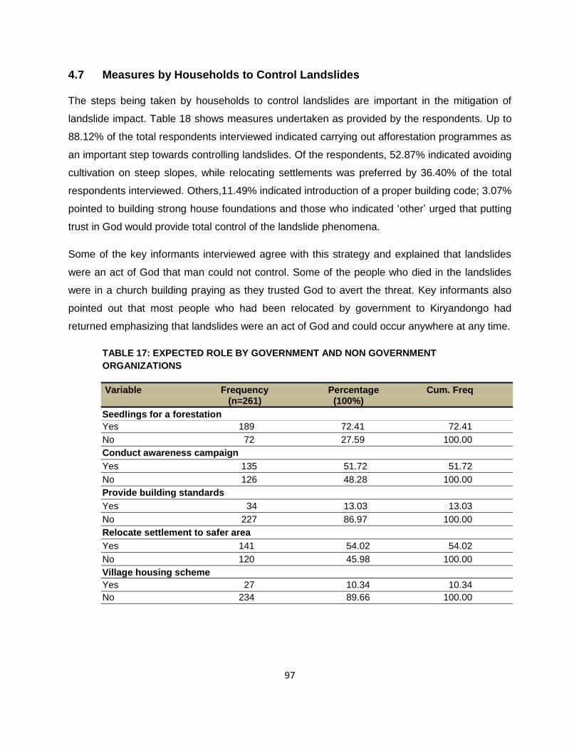
97
4.7 Measures by Households to Control Landslides
The steps being taken by households to control landslides are important in the mitigation of
landslide impact. Table 18 shows measures undertaken as provided by the respondents. Up to
88.12% of the total respondents interviewed indicated carrying out afforestation programmes as
an important step towards controlling landslides. Of the respondents, 52.87% indicated avoiding
cultivation on steep slopes, while relocating settlements was preferred by 36.40% of the total
respondents interviewed. Others,11.49% indicated introduction of a proper building code; 3.07%
pointed to building strong house foundations and those who indicated ‗other‘ urged that putting
trust in God would provide total control of the landslide phenomena.
Some of the key informants interviewed agree with this strategy and explained that landslides
were an act of God that man could not control. Some of the people who died in the landslides
were in a church building praying as they trusted God to avert the threat. Key informants also
pointed out that most people who had been relocated by government to Kiryandongo had
returned emphasizing that landslides were an act of God and could occur anywhere at any time.
TABLE 17: EXPECTED ROLE BY GOVERNMENT AND NON GOVERNMENT
ORGANIZATIONS
Variable Frequency Percentage Cum. Freq (n=261) (100%)
Seedlings for a forestation
Yes 189 72.41 72.41
No 72 27.59 100.00
Conduct awareness campaign
Yes 135 51.72 51.72
No 126 48.28 100.00
Provide building standards
Yes 34 13.03 13.03
No 227 86.97 100.00
Relocate settlement to safer area
Yes 141 54.02 54.02
No 120 45.98 100.00
Village housing scheme
Yes 27 10.34 10.34
No 234 89.66 100.00

98
TABLE 18: MEASURES BEING TAKEN BY HOUSEHOLDS TO CONTROL LANDSLIDES
Variable Frequency Percentage Cum. Freq (n=261) (100%)
Plant trees
Yes 230 88.12 88.12
No 31 11.88 100.00
Avoid cultivation on steep slopes
Yes 138 52.87 52.87
No 123 47.13 100.00
Relocate people
Yes 95 36.40 36.40
No 166 63.60 100.00
Proper building code
Yes 30 11.49 11.49
No 231 88.51 100.00
Build strong house foundation
Yes 8 3.07 3.07
No 253 96.93 100.00
Others (Put trust in God)
Yes 4 1.55 1.55
No 254 98.45 100.00
4.8 Conclusion
The chapter presented results of the data analysis based on the household survey,
observations and key informant interviews carried out. The section discussed the socio
demographic characteristics of households, economic status and awareness of landslides.
Regarding vulnerabilities, children were found to be the most vulnerable followed by elderly
persons. The main reasons for lack of awareness or information on landslide hazards were
discussed. Most households relied on assistance from NGOs and government to cope while
their major strength to adapt to the impact of landslides was derived from the presence of many
families around who provided company, counsel and other forms of support.

99
Chapter Five Vulnerabilities, resilience and mitigation measures
5.1 Household Vulnerability to Landslides
The purpose of this chapter is to discuss factors that have contributed to household
vulnerabilities to landslides in Bududa. The other issues that are discussed include household
awareness on landslides, warning, monitoring and mitigation mechanisms used by households
in Bududa. The chapter also discusses the capacity of households to cope, and how they deal
with shocks resulting from landslide threats.
The factors responsible for household vulnerability in any disaster situation have been
discussed in section 2.7. The section has also provided the different theoretical frameworks to
explain vulnerability such as the PAR model, Bohle conceptual framework etcetera. The factors
considered in here therefore are on the basis of the pressure and release (PAR) model and
these include location of settlements, income levels of households, special groups at risk,
unprotected buildings and government policy among others.
5.1.1 Location of Settlements
The location of settlements in Bududa led to increased household vulnerability to landslide
hazards. As observed during the field study, most of the settlements were located on steep
slope areas which are more susceptible to failure. The most affected area is located on the
rugged topography composed of interlocking spurs and steep slopes (Section 4.5, Figure 24).
The high population in the area attracted by the fertile agricultural soils and high rainfall has
resulted in increased pressure on land and other resources causing instability on the slopes.
The settlement activities such as cultivation, use of organic fertilizers, slope cutting for
construction of houses, animal husbandry and clearance of forests have resulted in destruction
of vegetation reducing the soil binding mechanisms. Knapen, et al. (2006:149) observed that the
effect of settlement on slopes of Mount Elgon in Uganda had increased the load on the deeply
weathered basements thereby altering the balance of forces operating on the slope.
100
5.1.2 Income levels of households
The social economic status of households is an important factor in assessing their vulnerabilities
to disasters (Wisner, et al. 2004:12). Analysing the economic and demographic characteristics
of households in Bududa showed that only 4.23% of the total respondents interviewed were
receiving a monthly payment, and the majority were poor with 14.23% having completely no
source of income (Table 5). The analysis shows that educational levels of households in
Bududa are low; only 4.23% of the total respondents attained tertiary level education while the
majority, 65.38% of the total respondents attained only primary education (Table 3).
Therefore the low levels of education attained coupled with the low incomes have resulted in
poor agricultural practices and over exploitation of the natural resources, such as forests
causing degradation to the fragile slopes. The inappropriate agricultural practices on the steep
slopes in Bududa can be attributed to the low levels of education. A large proportion of the
households depend on informal business activities like charcoal burning, which has resulted in
destruction of forests. These activities all led to increased likelihood of slope failures and
therefore increased vulnerability of households to landslide hazards. Alcantara-Ayala (2002)
observed that economic factors in developing countries played a significant role in increasing
vulnerabilities of rural communities to landslides.
5.1.3 Unprotected buildings and settlements
Households in Bududa were rendered vulnerable to landslide hazards because of the nature of
their dwellings and patterns of settlement. Analysis of types of dwelling in the study area
showed that 68.58% of the respondents interviewed lived in informal buildings. Those were
constructed using local materials mainly wood and wattle walls with grass thatched roofs (Figure
26). These kinds of buildings were weak and could not withstand any force from land sliding; on
the other hand the location of settlements was equally dangerous. Most of the homes were built
on steep slopes where soils were cut to provide a flat foundation (Figure 3 & 26). After such
cutting had, no reinforcement walls were built to provide protection, strength and guard against
the soil behind collapsing. That put the settlement at high risk from landslide hazards.
5.1.4 Special groups at risk
The analysis of most affected household members (Table 8) shows that 64.62% of those
affected by landslides in 2010 were children below the age of eighteen years of age. This was
followed by the elderly persons above the age sixty years old who comprised 21.07% of the

101
total respondents interviewed. The social characteristics of household members such as age,
gender, health status and disabilities (Wisner, et al., 2004:11) are important factors that
increase vulnerability to landslides hazards. In Bududa the young children were more vulnerable
because of their high population; they were too weak to run, were found at home and did not get
any information or warning about the threat of landslides. It was the same with elderly persons.
The children were also more vulnerable in this particular case, because they were returning
from school and being a rainy day, they had taken shelter in the nearby health centre which was
buried under the rabble of the landslide.
5.1.5 Lack of disaster preparedness
Disaster preparedness is an important factor to avoid death in the event a disaster occurring.
Advanced preparation, training and planning will facilitate the evacuation processes. Analysis of
the landslide awareness in Bududa shows that 91.51% of the total respondents interviewed
were aware of the 2010 landslides in Bududa (Table 6). But on the other hand, only 4.62% of
the total respondents interviewed said they had received warnings about the threat of an
impending landslide (Table 6). After the landslide had occurred, communities, rescue teams
from both private and government sector, including the military who were involved in rescue, did
not have equipment to use. Most of them were seen using hand and small hoes. This was
further worsened by the remote location of the place on the steep slopes of Mount Elgon without
road access to facilitate delivery of rescue equipment and emergency relief. The lack of
preparedness therefore hampered the rescue efforts; as illustrated by the absence of
neighbourhood based organizations to mobilise rescue labour, absence of effective risk
communication systems about landslides, and the lack of local personnel to carryout evaluation
and rescue activities. These left households in Bududa vulnerable to the impact of landslides.
5.1.6 Government policy
After the occurrence of landslides in 2010, the government of Uganda declared a state of
emergency in the area. The president issued instructions for the people to relocate to safer
areas. The relocation ground was identified at Kiryandongo. The process of relocation, however,
faced a lot of resistance from the local people who claimed that government wanted to remove
them and take over their ancestral land. Some of those who had been relocated returned
claiming that no alternative sources of livelihood were provided in Kiryandongo. There was need
to provide motivation, incentives and adequate awareness before house were relocated. The
102
government should also identify and provide alternative sources of livelihood in Bududa,
otherwise settlements and cultivation on steep slopes, cultivation and deforestation would
continue thereby increasing household vulnerability to slope failures.
The government needs to enact and enforce laws and bylaws that will prohibit activities such as
settlement on steep slopes of a certain degree. Such laws should also ensure protection of
forests and game reserves. The failure to enforce such laws and allowing households to
continue settlement on fragile slopes aggravates the problem of landslide hazards. Relocation
of settlements is the most appropriate solution to the problem. However, this requires strong
political will, awareness, motivation and provision of attractive incentives. If the government
remains silent, settlement on slopes will continue with its degradation impact resulting in
increased household vulnerability to landslide hazards.
5.2 Household Awareness of Landslides
The majority of the household heads interviewed in Bududa had either no schooling or only
primary schooling implying they were illiterate or semi literate. The total respondents
interviewed (91.51%), were aware of the 2010 landslide and others. One of the key informants
interviewed showed the researcher a boulder that he claimed rolled some years back as a result
of a landslide, which shows they were aware of the past landslides. The households were also
aware from experience that environmental degradation and heavy precipitation were the major
trigger factors for landslides.
The households were able to demonstrate their awareness and relate environmental
degradation activities which increased the occurrence of landslides. The increase in population
in Bududa resulted in increased settlement on the steep slopes and massive deforestation
which left the slopes bare and susceptible to land sliding. Such awareness was important in
generation of coping mechanisms and innovations that could be applied to mitigate landslide
hazards. Such awareness showed that households were aware of their environment and the
kind of changes taking place in it. Households were asked about their expectations regarding
the role of government and NGOs in controlling landslides. A majority responded that they
should provide seedlings for afforestation. That implied that communities were aware of the role
of trees in controlling landslides. Besides that, communities were aware of controlling

103
landslides. This kind of knowledge is important in the formulation of accepted measures to
mitigate and reduce household vulnerability to landslides.
5.3 Warning about Landslides
The main cause of landslides in Bududa indentified by households was high precipitation
resulting from heavy rain and cultivation on steep slopes. Early warning systems could reduce
damage to property and minimise losses of lives. As shown in Table 6, 95.38% of the total
respondents interviewed did not get any information or warning about an impending landslide
threat. Those who had the information received it by word of mouth, which was a rather slow
method for relying information relating to a disaster. Given the nature of the terrain in Bududa
that mode of communication was very ineffective. There was no early warning systems in place
to detect the threat of landslides early enough and to relay the information properly.
5.4 Household Resilience and Coping Mechanisms
A growing body of evidence suggests that most adults exposed to potentially traumatic events
are resilient. Resilience is a dynamic, evolving process of positive attitudes and effective
strategies (Jensen, et al., 2008:722). Almeldom and Tumwine (2008:3) observe that people,
despite formal and informal institutions that govern their lives and livelihoods, actively learn from
events and experiences including complex emergencies as and when they struggle to adapt
and reorganize with the goal of maintaining normal functioning. The main sources of household
resilience were entrenched in the way they perceived disasters as well as how they responded
to them. After the landslide disaster, the key sources of resilience and according to the
response in Bukalasi Sub County, included the following:
5.4.1 Social networking
Social networks and unity present, provided affected households a source of strength to deal
with the impact of disaster situations. Basic emotional support would normally be provided
through existing social networks. In many cases, family, friends and neighbours offered a
helping hand and a listening ear to survivors and their families in order for them to cope with
their loss and grief (Christensen, 2008:39). Pratt (2002) reveals that Kenyans in drought
situations operated through social networks. They came together, prayed and prepared
themselves psychologically and physically. In Bududa, social networks included prayer groups,

104
burial groups and local saving groups. These groups provided moral, financial and material
support services to those who were affected by the landslide disaster, for example they
temporarily accommodated those who were displaced, provided counselling, shelter, food and
clothing for them. That helped many of the landslide victims to cope with life. It is important to
note that these social networks are built on the basis of knowledge, beliefs, and moral principles
of the community.
5.4.2 Prayer
Some of the affected households understood that the landslide disaster was the making of God
and God was well aware of it. Some saw it as an act of punishment by God, but they urged that
such occurrence still had to be turned to the same God as a source of strength. Community
members and households turned to God and sought to know why he permitted such an
occurrence. They prayed to him for strength, repented of their sins and changed their ways of
life. They also implored him not to permit such phenomena again. They felt that God had
responded to their prayers, they received hope and strength to move on with life despite the
challenges they still had to face. The evidence of deriving strength from prayers is not only
limited to households in Bududa who suffered landslides. Jensen, et al. (2008:726) observes
that spirituality is a reflection of deep philosophical questions, and prayer is the way to gain
perspective because it is very important and it helps. According to Dekens (2007:27,) Kenyan
communities used prayers during drought situations and this involved other actions which
enabled community members to come together and prepare physically and mentally. Mooney
(2010:1) points out that the main response and source of disaster resilience for households in
Haiti were prayer.
5.4.3 Relocation of settlements
Some of the households in Bududa accepted the fact to be relocated and resettled in other
places. They felt that moving to live in a newer place could enable them to forget the bad
memories from the landslide disaster. Such new places provided household members with new
sources of strengths, opportunities and outlook on life. All these are mechanisms for coping
which facilitate psychological healing.
105
5.4.4 Psychosocial support
This is a process of facilitating resilience within individuals, families and communities. It involves
respecting individuals and communities‘ independence, dignity and coping mechanisms
(Dougall, et al., 2001:224). Psychosocial support promotes the restoration of social cohesion
and infrastructure. It advocates the use of community-based approach to promoting resilience
and strengthening coping mechanisms within individuals, families and the wider community
(Bonanno, et al., 2007:673). Some examples of community-based psychosocial support
activities that are seen to be effective at times of crises include: Supporting the return to school,
work, normal daily routines, play and recreational activities, school-based programmes, children
and youth clubs, religious and cultural ceremonies, community sensitization to increase
awareness on psychological reactions to critical events, drama, art, cultural activities, livelihood
oriented activities and life-skills training, supporting families to function and supporting those
who support others.
The households in Bukalasi Sub County proposed that the government should reopen the
schools that were closed to enable their children to return to school. They also proposed
rebuilding of the health centre that was destroyed by the landslides in 2010. One of the key
informants interviewed, revealed that they were holding ―Bull fight‖ games every week as a way
of providing recreation to the community. These he claimed helped them forget the landslide
experience and carry on.
5.4.5 Accessing government and nongovernment aid
During a crisis such as landslides, access to support from government and nongovernment
organizations is clearly a coping mechanism for households. In the case of Bududa, 26.05% of
the household heads interviewed indicated that they were able to withstand the impact of
landslides through support from organizations such as the nongovernment and community
based organizations. Glandon, et al. (2008:25) in their study of household resilience in post
Katrina, point out that participants who continue to be displaced mentioned grassroots
organizations as having played a very important role in building and promoting community
resilience. It is important to note that most of such organizations work to extend their original
mission in order to help the worst affected local communities and households recover from the
disaster regardless of individual memberships with them. The households in Bududa mainly

106
mentioned the role of the Red Cross Society of Uganda and the government as having helped
them manage the impact suffered from the landslides.
5.5 Mitigation Measures
The purpose of presenting the suggested mitigation measures is to reduce vulnerability and
exposure to landslide hazards. Following are some of the mitigation measures that can be used
to mitigate landslides and reduce household vulnerability in Bududa.
5.5.1 Slope rehabilitation and afforestation
The study observes that extensive deforestation on the steep slopes in Bududa for the purpose
of settlement and agriculture has contributed to increased landslide activity in the area. Tree
planting may help stabilise the slope through increased evaporative losses associated with tall
and deep rooted trees. A careful selection of tree species for planting should be carried out.
This can be achieved if done in conjunction with the National Forestry Authority (NFA).
5.5.2 Limiting activities in the hazard prone areas
The government needs to control human activities that contribute to slope instability in the
landslide hazard prone areas. Cultivation on steep slopes can be controlled, completely banned
or be permitted depending on the crop to be grown and other husbandry practices to be
followed. The agricultural extension workers at the district and sub county level need to intensify
awareness campaigns on appropriate land use and husbandry practices.
5.5.3 Community participation on development of mitigation measures
For the landslide measures to be effective and acceptable, the affected communities should be
involved in their formulation. This is important because such measures will be implemented in
the affected communities and the affected households will be the implementers. The forest
reserve at Nametsi has been destroyed by communities for agricultural purpose; this could be
partly because they are not part of the management of the reserve. If the government through
the NFA can involve the local people through collaboration, their participation in protecting the
resource would be greater, which in turn increases their resilience to hazards, hence reduced
vulnerability.

107
5.5.4 Public awareness campaign
Household vulnerability to landslide hazards can be reduced through public awareness
campaigns and outreach on the causes, contributing factors and mitigation techniques. Most
people in Bududa are aware that landslides are triggered by heavy precipitation coupled with
bare steep slopes that have been cleared for agricultural production. But they cannot stop this
because households need food and the population continues to grow. Clear understanding
needs to be created on production systems, and measures to control population explosion must
be advocated such as family planning; this will go a long way to support attempts to mitigate
landslides. Public awareness campaigns can be done by extension workers, NGO groups,
church leaders, district environmental and agricultural officers. Such programmes as landslide
hazard safety, community risk reduction training, and media campaigns on landslide hazard risk
area can be used to achieve this.
5.5.5 Government participation
After the landslide of 2010 in Bududa, the response from government was described as slow
and constrained regarding the availability of resources and equipment. The government through
the line ministry of disaster preparedness and refugees should develop a disaster preparedness
policy and plans on how to respond to disasters promptly. This can be achieved by funding
research by individuals and institutions on slope stability problems. The government should
develop policies on implementation of landslide hazard mitigation measures and land use
planning. This should be incorporated into the emergency operation plan.
Households in Bududa live in temporary informal shelters which are vulnerable to landslide
hazards. The government should develop and enforce building codes and standards so that
houses are built to withstand landslide hazards. A village housing scheme being implemented in
Kiryandongo is meant to act as a motivator for relocation to safer grounds. Given the high levels
of household vulnerability still in Bududa, and the need to conserve the natural environment,
forests and the game reserve, government should promote relocation of settlements. A process
of consultation, trust building and provision of incentives can help achieve this. The danger of
settlement on hazard prone areas also needs to be properly explained to gain willingness to
move.

108
5.5.6 Early warning and monitoring systems
The Bududa landslides as noted earlier on, were triggered by high precipitation. An early
warning system if developed and established could warn people in advance. This could reduce
damage to property, minimise loss of lives and provide timely information to all stakeholders
involved in management. Meanwhile monitoring of landslide activity over a wide area could be
important for the purpose of mapping landslide hazards and landslide risk assessment.
5.6 Conclusion
The chapter has highlighted the causes of household vulnerability to landslide hazards in
Bududa. The threat of landslide hazards continues looming in Bududa because currently there
is little or no effort in place to reduce landslide hazards and damage. The relocation programme
by government is facing resistance from households and it is yet to be concluded. The
government is yet to commission studies and projects that will carry out mapping of landslide
prone areas in Bududa, and improve on funding allocated to emergency management and
response. An effective landslide mitigation programme is important because it addresses
emergency management response and may assist in the reduction of landslide impact in the
long run.
109
Chapter Six Conclusions and recommendations
6.1 Conclusions
This chapter presents conclusions, recommendations and areas for further study based on the
discussion of results presented in Chapters 4 and 5. This study was conducted in the district of
Bududa, eastern Uganda, in the sub county of Bukalasi. The study covered the villages of
Nametsi, Kubewo, Nambele, Murwerwe, Masakanu and Tunwasi. The main objective of the
study was to assess household vulnerabilities, resilience and coping mechanisms to landslides
in Bududa district, Eastern Uganda; evaluate the level of household awareness on landslide
hazards, examine the landslide hazard early warning, monitoring and mitigation mechanisms
and to assess the capacity of households to cope with landslides, future shocks and to propose
landslide hazard mitigation measures in Bududa.
The study established that landslides in Bududa caused loss of lives and injuries to the people.
In 2010, for example at Nametsi village, over 300 people lost their lives when their houses got
buried under rabble by landslides. This was the highest death toll ever experienced as
compared to the previous landslides in the area. The landslides caused economic losses in the
affected areas through destruction of crops in the field and storage; destruction of farmland,
houses and killing domestic animals.
The data analysis results suggested that landslides in Bududa occurred as a result of heavy
precipitation. The type of mass movement that was experienced was a debris flow. This occurs
when masses of poorly sorted sediments, agitated and saturated with water move down slope.
They occur suddenly and can submerge an area in a matter of minutes.
The destruction of forest cover in the area for settlement, cultivation, settlement on steep slopes
and increased rainfall are the major contributing factors to slope instability in Bududa resulting in
landslides.
Household vulnerability to landslides in Bududa was mostly caused by lack of awareness,
location of homes and settlements on steep slopes, low levels of income with no steady monthly

110
income for households and reliance on informal forms of employment that increased their
vulnerability to slope failures.
Household production systems were also found to contribute to landslide occurrences in
Bududa. In Nametsi, for example cultivation on steep slopes, destruction of vegetation through
cutting of trees for charcoal burning and wood for cooking fuel. Grazing of animals such as
goats and cattle were observed as some of the factors that led to increased pressure on the
steep slopes. The failed relocation of communities as proposed by government and the difficulty
in accessing the area hampered delivery of emergency assistance and rescue equipment. That
increased vulnerability of the victims.
6.2 Resilience and Coping
The study indicated that the low level of income for households, absence of effective
communication medium and lack of landslide mapping by government contributed to household
vulnerability to landslides in Bududa. These also resulted in reduced household resilience to
disasters. Household coping strategies were discussed by the study; they included presence of
many families around to provide the counsel, talking to friends, prayers to God, settling with
friends, drinking alcohol and support from non government organizations and government.
Ever since the landslides occurred in Bududa in March 2010, no rehabilitation had been
undertaken; the health centre that was buried under rubble has not been rebuilt. This increases
vulnerability of households and risk of another landslide occurring, especially where the slopes
have remained bare. Households are, however, aware of what needs to be done, although the
local initiative is lacking. The households believe that the government and the non government
organizations should provide seedlings for afforestation, introduce village housing schemes and
carry out awareness campaigns on the causes and dangers of landslides.
6.3 Suggested Areas for Further Study
This section presents suggested areas for further research. The recommended suggestions
have been formulated in light of the limitations of the study.
After the occurrence of the 2010 landslides, the government immediately ordered relocation of
all the people living in the landslide prone areas. The communities in Bududa, however, found

111
this as forced eviction from the Mount Elgon national park and many resisted relocation. A
detailed survey needs to be carried out to assess household willingness to move to safer
grounds. The survey should also address issues relating to incentive packages, which could
motivate people to move to Kiryandongo.
As observed in this study, there has been increased frequency in the occurrence of landslides in
Bududa as a result of high and prolonged precipitation, which is an indication of climate change.
It is important therefore to assess the impact of climate change on the occurrence of landslides.
The study recommends further study to be carried out in other parts of Uganda that have
experienced landsides such as Bulambuli, Manafa, Kapchorwa and the slopes of Mount
Ruwenzori in the west, to provide a comparative basis for future studies. The studies will also
generate information that will form a basis for land mapping and assessment. It is also
suggested that a study be carried out to address the gender implications of landslides,
traditional knowledge and perceptions of local people on the occurrence of landslides.
6.4 Limitations of the Study
This study was an attempt to assess factors for household vulnerabilities, resilience and coping
mechanisms with landslide hazards in Bududa. The research work was, however, affected by
limited funding. It was difficult to expand the area of assessment beyond one sub-county, carry
out field experiments and modelling. As a developing nation, Uganda still lacks the technical
capacity and financial resources to facilitate research work.

112
REFERENCES
Adger, W.N.T.P., Hughes, S., Folke, S.R., Carpenter, & Rockström, J. 2005. Social-ecological
resilience to coastal disasters, Science, 309:1036–1039.
Alam, K. 2006. Why should community coping mechanisms be the centre of disaster reduction
policy and practices? [Online] Available: http://www.khurshidalam.org [12 July 2011].
Alcantara-Ayala, I. 2004. Hazard assessment of rainfall induced land sliding in Mexico.
Geomorphology, 16:19-40.
Alexander, D. 1993. Natural Disaster, London, University College Library Press.
Allen, K. M. 2006. Community-based disaster preparedness and climate adaptation: local
capacity-building in the Philippines, Disasters, 30:81–101.
Anderson, M.G., Holcombe, E., Blake, J.R., Ghesquire, F., Holm-Nielsen, N. & Fisseha, T.
2011. Reducing landslide risk in communities: evidence from the Eastern Caribbean. Applied
Geography, 31:590 – 599.
Atuyambe, L.M., Ediau M., Orach, C.G., Musenero, M.& Bazeyo, W. 2011. Landslide disaster in
Eastern Uganda: rapid assessment of water, sanitation and hygiene situation in Bulucheke
camp, Bududa district. Environmental Health 10:38,1-13. [Online] Available:
http://www.ehjournal.net/content/10/1/38 [3 September 2011].
Almedom, A.M. 2008. Resilience research and policy/practice discourse in health, social,
behavioural and environmental sciences over the last ten years. African health sciences,
8:(S),5-13.
Baas, S., Ramasamy, S., DePryck, J.D. & Batista, F. 2008. Disaster management systems
analysis: a guide book, Food and Agricultural Organization (FAO). [Online] Available:
ftp://ftp.fao.org/docrep/fao/011/i0304e/i0304e.pdf [4 March 2010].
BDLG (Bududa District Local Government). 2007. Orphans and other vulnerable Children, five
year district strategic plan. Kampala: Core initiative. [Online] available:
http://www.coreinitiative.org [01 September 2010]

113
Bankoff, G. 2007. Living with risk, coping with disasters: Hazards as a frequent life experience
in the Philippines. Education about Asia, 12:2,26-29. [Online] Available:
http://www2.hull.ac.uk/fass/pdf/LivingWithRisk.pdf [20 June 2011].
Bartlett, J.E., Kotrlik, J.W. & Higgins, C.C. 2001. Organizational research, determining
appropriate sample size in survey research. Information technology learning and performance
journal, 19:1,43–50. [Online] Available: http://www.osra.org/itlpj/bartlettkotrlikhiggins.pdf [17
October 2011]
Bates, F.L. & Peacock, W.G. 1992. Measuring disaster impact on household living conditions:
the domestic assets approach. Journal of mass emergencies and disasters, 10:1,133-160.
[Online] available: http://www.ijmed.org/articles/127/download/ [30 August 2011].
Benson, C. & Clay, E.J. 2004. Understanding the economic and financial impact of natural
disasters. The World Bank. Washington DC.
Berkes, F. 2007. Understanding uncertainty and reducing vulnerability: lessons from resilience
thinking. Natural Hazards, 41:283–295.
Birkmann, J. 2006. Measuring vulnerability to natural hazards: Towards disaster resilient
societies. UNU press, [Online] Available: http://i.unu.eduf [26 June 2010].
Bohle, H.G. 2001. Vulnerability and Criticality: Perspectives from Social Geography. IHDP
Update 2/2001, Newsletter of the International Human Dimensions Programme on Global
Environmental Change: 1–7.
Bonanno, G.A., Galea, S., Bucciarelli, A. & Vlahov, D. 2007. What predicts psychological
resilience after a disaster? The role of demographics, resources and life stress. Journal of
consulting and clinical psychology, 75:5,671 – 682.
Bolin, R.C. 1985. Disaster characteristics and psychosocial impacts. in B.J. Sowder (ed.)
Disasters and Mental Health: Selected contemporary perspectives, 3-28. Rockville, MD:
National Institute of Mental Health.
Bogardi, J. & Birkmann J. 2004. Vulnerability Assessment: The first step towards sustainable
risk reduction, in Malzahn, D. & Plapp, T. (eds) Disaster and society – from hazard assessment
to risk reduction, Berlin: Logos Verlag Berlin, pp. 75–82.
114
Boyd, J. & Eckert, P. 2002. Creating resilient educators: a global learning community‘s manual.
Tasmania: Global learning communities. [Online] Available:
http://www.vision.net.au/~globallearning/pages/newservs/nsfr.htm [8 June 2011].
Brahmi, A., & Poumphone, K. 2002. Study on local coping mechanisms in disaster
management. Case studies from the Lao PDR. [Online] Available:
http://www.onlinewomeninpolitics.org. [13 May 2011].
Bryant, E.A. 1991, Natural Hazards, Cambridge, Cambridge University Press.
Bruneau, M., Chang, S., Eguchi, R., Lee, G., O‘Rourke, T., Reinhorn, A., Shinozuka, M.,
Tierney, K., Wallace, W., & VonWinterfelt, D. 2003. A framework to quantitatively assess and
enhance the seismic resilience of communities, EERI spectra journal, 19(4):733-752.
Cannon, T. 2000. Vulnerability analysis and disasters, In D. J. Parker (ed.), Floods (2 vols),
Routledge, London [online] available: http://www.radixonline.org/ [10 July 2011].
Cardona, O.D. Hurtado, J.E. Duque, G, Moreno, A. Chardon, A.C. Vela´ squez, . L.S. & Prieto
S.D. 2003. The Notion of Disaster Risk. Conceptual Framework for Integrated Risk
Management, IADB/IDEA Program on Indicators for Disaster Risk Management, Universidad
Nacional de Colombia, Manizales. [Online]: Available: http://idea.manizales.unal.edu.co/ . [17
August 2011].
Cannon, T., Twigg, J. & Rowell, J. 2003. Social Vulnerability, Sustainable Livelihoods and
Disasters, Report to DFID Conflict and Humanitarian Assistance Department (CHAD) and
Sustainable Livelihoods Support Office. [online] Available: http://www.benfieldhrc.org . [19 July
2011].
Cardona, O.D. 2001. Estimacio´n Holı´stica del Riesgo Sı´smico Utilizando Sistemas
Dina´micos Complejos, Barcelona: Technical University of Catalonia. [Online] Available:
http://www.desenredando.org . [14 August 2011].
Chambers, R. & Conway, G. 1992. ‗‗Sustainable Rural Livelihoods: Practical Concepts for the
21st Century‘‘, IDS Discussion Paper 296, Brighton: Institute of Development Studies.
Chan, N.W. 1998. Responding to landslide hazards in rapidly developing Malaysia: A case of
economics versus environmental protection. Disaster prevention and management, 7:1, 14-17.

115
Chandra, A., Acosta, J., Stern, S., Uscher-Pines, L., Williams, M.V., Yeung, D., Garnett, J. &
Meredith, S. 2011. Building community resilience to disaster: technical report. [Online]Available:
http://www.rand.org [10 May 2011].
Christensen, L. 2008. From trauma to resilience. African health science, 8: (s), 39-40.
Chen, S.C., Ferng, J.W., Wang, Y.T., Wu, T.Y., & Wang, J.J. 2008. Assessment of disaster
resilience capacity of hills lope communities with high risk for geological hazards. Engineering
geology, 98:86-101.
Chenery, E. M. 1960. An introduction to the soils of the Uganda Protectorate, Memoirs of the
Research Division, series 1, number 1, Department of Agriculture.
Cohen, M. & Sebstad, J. 2005. Reducing vulnerability: the demand for microinsurance. Journal
of international development, 17:397-474.
Comerio, M.C. 1997. Housing issues after disasters. Journal of Contingencies and Crisis
Management 3:166-178.
Committee on Disaster Research in Social Sciences. (CDRSS), 2006. Facing hazards and
disasters, understanding human dimensions, the national academies press, Washington D.C.
[online] available: http://www.nap.edu. [12 July 2010].
Corominas, J., Remondo, J., Farias, P., Esterao, M., Zezere, T., Dias de Teran, J., Dikan, R..
Schott, L., Moya, J. & Gonzalez, A. 1996. Debris flow, International Association of
Geomorphologists, 5, 61 - 180.
Cutter, S.L., Boruff, B.J. & Shirley, W.L. 2003. Social vulnerability to environmental hazards.
Social science quarterly, 84:22,242-261. [Online] available: http://www.colorado.edu [20 August
2011].
Cutter, S. L., Barnes, L., Berry, M., Burton, C., Evans, E. & Tate, E. 2008. A place-based model
for understanding community resilience to natural disasters. Global Environmental Change, 18,
598–606.
Dai, F.C., Lee, C.F. & Ngai, Y.Y. 2002. Landslide risk assessment and management: an
overview. Engineering geology, 64:65-87.

116
Dougall, A.L., Hyman, K.B., Hayward, M.C., McFeeley, S. & Baum, A. 2001. Optimism and
trauma: the importance of social support and coping. Journal of applied social psychology, 31:2,
223-245.
Davis I, Haghebeart, B. & Peppiatt, D. 2004. Social Vulnerability and Capacity Analysis.
Discussion Paper and Workshop Report, ProVention Consortium: Geneva.
de Haan, L. & Zoomers, A. 2005. Exploring the Frontier of Livelihood Research, Development
and Change, 36:1, 27–47.
Dekens, J. (2007) Local Knowledge for Disaster Preparedness, a literature review. Kathmandu
Nepal: International Centre for Integrated Mountain development (ICIMOD). [Online] Available:
http://www.preventionweb.net/ [7 July 2010].
Department for International Development, (DFID). 1999. Sustainable Livelihood Guidance
Sheets, London: DFID. [Online] Available:
http://www.livelihoods.org/info/info_guidancesheets.html. [3rd July 2011]
Dilley, M., Chen, U., Deichmann, U., Lerner-Lam, A.L., Arnold, M., AGWE, J., Buys, P.,
Kjekstad, O., Lyon, B., and Yetman, G. 2005. Natural Disaster Hotspots: A global risk analysis,
International Bank for Reconstruction and Development/The World Bank and Columbia
University, Washington, D.C [Online] Available: http://sedac.ciesin.columbia.edu [12 August
2011]
Dorren, L.K.A., 2004. A review of rock fall mechanics and modeling approaches. Progress in
physical geography 27:1, 69-87. [Online] Available: http://ppg.sagepub.com/content/27/1/69. [3
June 2011].
Downing, T. 2004. What Have We Learned Regarding a Vulnerability Science? in Science in
Support of Adaptation to Climate Change. Recommendations for an Adaptation Science
Agenda and a Collection of Papers Presented at a Side Event of the 10th Session of the
Conference of the Parties to the United Nations Framework Convention on Climate Change,
Buenos Aires, 18–21. [Online] Available: www.aiaccproject.org/ [7 December 2004].
Drabek, T.E. 1986. Human System Responses to Disaster: An Inventory of Sociological
Findings. New York: Springer Verlag.

117
Dynes, R.R. 1993. Disaster reduction: The importance of adequate assumptions about social
organization. Sociological Spectrum 6:24-25.
Dynes, R.R. 1970. Organized Behavior in Disaster. Lexington, MA: Heath-Lexington Books.
Dynes R.R. 1994. Community emergency planning: false assumptions and inappropriate
analysis. International journal of mass emergencies and disasters, 12(2):141-158. [Online]
Available:http://dspace.udel.edu:8080/dspace/bitstream/handle/19716/1626/Article%20275.pdf?
sequence=1 [2 October 2011].
Douglas C.H. 2006. Editorial. Small island states and territories: sustainable development
issues and strategies – challenges for changing islands in a changing world. Sustainable
Development, 14:75–80.
Economic Commission for Latin America and the Caribbean (ECLAC). 2003. Handbook for
estimating the socio-economic and environmental effects of disaster. The World Bank. [Online]
Available: www.undp.org/ [3 May 2010]
Ecweru, M. 2011. Don‘t ridicule the disaster ministry; play your role – disaster response. Daily
monitor, Ugandan news paper, 9 September, 2011:13.
Edyegu, D. 2010. Bududa IDPs complain of mishandled relocation. New Vision news paper, 2
November 2010 [Online] Available: http://www.newvision.co.ug/D/8/17/736895. [2 September
2011].
Eeckhaut, M.V.D., Poesen, J. Vandekerckhore, L., Gils, M.V. & Rompaey, A.V. 2010. Human
environment interactions in residentiall areas susceptible to landsliding; the Flemish area case
study. Area, 42:3, 339-358.
Emergency Capacity Building, 2006. Leaving disasters behind. [Online] Available:
http://www.ecbprojects.org/ [8 May 2011].
Fitzgerald, G., & Fitzgerald, N. 2005. Assessing community resilience to wildfires: Concepts and
approach. A paper presented to SCION research. [Online] Available: http://www.tba.co.nz/
[3 June 2011].

118
Folke, C. S., Carpenter, T. Elmqvist, L. Gunderson, C. S., Holling & Walker, B. 2002. Resilience
and sustainable development: building adaptive capacity in a world of transformations, Ambio
31:5, 437–440.
Gaillard, J.C. 2010. Vulnerability, capacity and resilience: perspectives for climate and
development policy. Journal of international development, 22:218-232.
Galli, M. & Guzzetti, F. 2007. Landslide vulnerability criteria: a case study from Umbria Central
Italy. Environmental management, 40:649-664.
Gardner, J. S. & Denkens, J. 2007. Mountain hazards and the resilience of social-ecological
systems: lessons learned in India and Canada. Natural Hazards, 41:317–336.
Gerrity, E.T., & B.W. Flynn. 1997. Mental health consequences of disasters. In E.K. Noji (ed.)
The Public Health Consequences of Disasters, 101-121. New York: Oxford University Press.
Glandon, D.M., Muller, J. & Almedom, A.M. 2008. Resilience in post-Katrina New Orleans,
Louisiana: a preliminary study. African health sciences, 8:S1, S21-S27.
Msilimba, G.G. & Holmes, P.J. 2005, A Landslide Hazard Assessment and Vulnerability
Appraisal Procedure; Vunguvungu/Banga Catchment, Northern Malawi. Natural Hazards, 34:
199 – 216
Gondwe, P. C. & Govati C.C. 1991, The Stability status of Mishesi Mountain unpublished report,
Zomba, Geological Survey Department.
Gorokhorich, Y. & Doocy, S. 2010. Preliminary results of the Bududa landslide geological survey
and needs at Bulucheke camp for the displaced populations. [Online] Available:
http://www.jhsph.edu/ [19 November 2011]
Guha-Sapir, D., Vos, F., Below, R. & Ponserre, S. 2010. Annual Disaster Statistical Review
2010: The Numbers and Trends, CRED, 2011 Brussels. [Online] Available:
http://www.cred.be/sites/default/files/ADSR_2010.pdf. [12 August 2011].
Guzzetti, F. 2003. Landslide hazard assessment and risk evaluation: limits and prospective.
Proceedings of the 4th EGS plinium conference held at mallorca, Spain, October 2002 [Online]
Avaialable: http://www.uib.es/ [10 August 2011]
119
Holling, C.S. 1973. Resilience and Stability of Ecological Systems. Annual Review of Ecology
and Systematics, 4:1-23.
Haigh, R. & Amaratunga, D. 2010. An integrative review of the built environment discipline‘s role
in the development of society‘s resilience to disasters. International journal of disaster resilience
in the built environment, 1:1, 11-24.
Huabin, W., Gangjun, L., Weiya, X., & Gunghui, W. 2005. GIS-based landslide hazard
assessment: an overview. Progress in physical geography, 29(4):548-567. [Online] Available:
ppg.sagepub.com [3 June 2011].
Huppert, H.E. & Sparks, R.S. 2006. Extreme natural hazards: population growth, globalization
and environmental change. Philosophical transactions: mathematics, physics and engineering
sciences, 364:1845,1875-1888.
Inganga, S. & Ucakuwun, E. 2001, Rate of Swelling of Expansive Soils: A critical Factor in
Triggering of Landslides and Damage to Structure, Documenta Naturae 136: 93 – 98.
International Federation of Red Cross and Red Crescent Societies. 2006. World Disaster
Report, focus on neglected crises. [Online] Available: http://www.ifrc.org [8 June 2011].
Jamali, A.A. & Abdolkhani, A. 2009. Preparedness against landslide disaster with mapping of
landslide potential by GIS – SMCE (Yazd – Iran). International journal of geoinformatics,
5(4):25–31.
Jensen, P.M., Trollope-Kumar, K., Waters, H. & Everson, J. 2008. Building physician resilience.
Canadian family physician, 54:722-729.
Kamp, U., Growley, B.J., Khattak, G.A. & Owen L.A. 2008. GIS-based landslide susceptibility
mapping for the 2005 Kashmir earthquake region. Geomorphology, 101:631-642.
Khandker, S. 2007. Coping with floods: role of institutions in Bangladesh. Agricultural
economics, 36:169-180.
Keim, M.E. 2008. Building human resilience: The role of public health preparedness and
response as an adaptation to climate change. American journal of preventive medicine, 35:5,
508-516.
120
Kaplan, H.B. 1999. Towards an understanding of resilience. A critical review of the definitions
and models. In Glantz, M.D. & Johnson, J. (eds) Resilience and development: positive life
adaptation. New York:Plenum Press.
Kasperson, R. 2005. Human Vulnerability to Global Environmental Change: The State of
Research, Presentation at the Fifth Annual IIASA-DPRI Forum Integrated Disaster Risk
Management, Innovations in Science & Policy, 14–18 September 2005, Beijing.
Kuban, R., & MacKenzie-Carey, H. 2001. Community-Wide Vulnerability and Capacity
Assessment (CVCA). Office Critical Infrastructure Protection and Emergency Preparedness.
[online] available: http://www.pegasusemc.com/pdf/CVCAreport.pdf [20 July 2011].
López-Marrero, T. & Tschakert. 2011. From theory to practice: building more resilient
communities in flood-prone areas. Environment and Urbanization, 23: 229-249.
Ludman, A. & Koch, N.I. 1982, Physical Geology, London, McGraw-Hill Book Company.
Kaynia, A.M., Papathoma-Kőhle, M., Neuhäuser, K., Wenzel, H., & Madina-Centina, Z. 2008.
Probabilistic assessment of vulnerability to landslides: application to the village of Lichtenstein,
Baden-Württemberg, Germany. Engineering geology, 101:34-48. [Online] Available:
www.elsevier.com/locate/enggeo [8 June 2011].
Kerle, N. & de Vries, B.V.W. 2001. The 1998 debris avalanche at Casita volcano, Nicaragua—
investigation of structural deformation as the cause of slope instability using remote sensing.
Journal of Volcanology and Geothermal Research, 105:(1–2), 49– 63.
Kitutu, M., Muwanga, A., Poesen, J., & Deckers, J. 2004. The Relationship between geology
and landslides in Manjiya County, South west of Mount Elgon, Eastern Uganda. Geoscience
Africa 2004 Conference, Abstract volume (1), University of Witwatersrand, Johannesburg, South
Africa. Pp. 349-350.
Kitutu, M., Muwanga, A., Poesen, J. & Deckers, J. 2011. Farmer‘s perception on landslide
occurrences in Bududa district, Eastern Uganda. African journal of agricultural research, 6:7–18.
[Online] Available: http://www.academicjournals.org/AJAR [15 March 2011].
Kitutu, M., Muwanga, A., Poesen, J. & Deckers, J. 2009. Influence of soil properties on landslide
occurrences in Bududa district, Eastern Uganda. African journal of agricultural research, 6:7–18.
[Online] Available: http://www.academicjournals.org/AJAR [20 March 2011].

121
Kizza, J. 2011. Landslides looming in Eastern Uganda. The New Vision: 2, June 8. [Online]
Available: http://ipsnews.net/news.asp?idnews=50612 [10 June 2011].
Kjekstad, O. & Highland, L. 2009. Economic and social impact of landslides. In Sassa K. &
Canuti, P. (eds). Landslides – disaster risk reduction, Springer–Verlag Berlin Heidelberg.
Knapen, A., Kitutu, M.G., Poesen, J., Breugelmans, W., Deckers, J. & Muwanga, A. 2006.
Landslides in a densely populated county at the foot slopes of Mount Elgon Uganda,
Characteristics and causal factors, Geomorphology, 73:(1-2), 149-165.
Kuban R, & MacKenzie-Carey H. 2001. Community-Wide Vulnerability and Capacity
Assessment (CVCA). Office of Critical Infrastructure Protection and Emergency: Preparedness:
Ottawa.
Kumpfer, K. 1999. Factors and processes contributing to resilience: the resilience framework. In
Glantz, M.D. & Johnson, J. (eds). Resilience and development: positive life adaptation. New
York: Plenum Press.
Lacasse, S. & Nadim, F. 2009. Landslide risk assessment and mitigation strategy. In Sassa, K.
& Canuti, P. (eds) Landslide disaster risk reduction. Springer-Verlag Berlin Heidelberg
Larsen, M.C., Simon, A., 1993. A rainfall intensity-duration threshold for landslides in a humid-
tropical environment, Puerto Rico, Geografiska Annaler Series A. 75:(1–2),13–23.
Lecomte, E., & K. Gahagen, 1998. Hurricane insurance protection in Florida. 97-124 in
Kunreuther, H. & Richard J. R., Sr. (eds.) Paying the Price: The Status and Role of Insurance
Against Natural Disasters in the United States. Washington, DC: Joseph Henry Press. [Online]
available: http://www.nap.edu [24 September 2011].
Levine, C. 2004. The concept of vulnerability in disaster research. Journal of traumatic stress
disorder, 17:5, 395-402.
Lin, M.L. & Jeng, F.S. 2000. Characteristics of hazards induced by extremely heavy rainfall in
Central Taiwan-Typhoon Herb, Engineering Geology, 58:191–207.
Lindell, M.K. & Prater, C.S. 2003. Assessing community impacts of natural disasters. Natural
hazards review, 4:4,176-185. [Online] available: http://apps.asce.org/ [1 September 2011].

122
Living with risk. 2002. A global review of disaster reduction initiatives, UNISDR. [Online]
Available; www.unisdr.org [10 May 2011].
Mallick, B., Rahaman, K.R. & Vogt, J. 2011. Social vulnerability analysis for sustainable disaster
mitigation planning in coastal Bangladesh. Disaster prevention and management, 20:3, 220-
237.
Mampane, R. & Bouwer, C. 2006. Identifying resilient and non resilient middle adolescents in a
formally black only urban schools. South African journal of education, 26:3, 443-456.
Maruland, M.C., Cardona, O.D. & Harbat, A.H. 2010. Revealing the social economic impact of
small disasters in Colombia using the desinventar database. Disasters, 34:2, 552-570.
McCall, G.J.H. 1992, Geohazards Natural and Man-Made, London. Chapman and Hall.
McEntire, D. 2011. Understanding and reducing vulnerability from the approach of liabilities and
capabilities. Disaster prevention and management, 20:3, 294-313.
McEntire, D., Crocker, C.G. & Peter, E. 2010. Addressing vulnerability through an integrated
approach. International journal of disaster resilience in the built environment, 1:1, 50-64.
Moayedi, H., Huat, B.B.K., Ali, T.A.M., Asadi, A., Moayed, F. & Mokhberi. 2011. Preventing
landslides in times of rainfall, Case study and FEM analysis. Disaster prevention and
management, 20:2, 115-124.
Mooney, M.A, 2009. Haiti, now and next: Disaster, Religion and Resilience. The Immanent
Frame. [Online] Available: http://blogs.ssrc.org [19 May 2010].
Msilimba, G.G. & Holmes, P.J. 2005. A Landslide Hazard Assessment and Vulnerability
Appraisal Procedure; Vunguvungu/Banga Catchment, Northern Malawi. Natural Hazards 34:
199 – 216.
Nathan, F. 2008. Risk perception, risk management and vulnerability to landslides in the hill
slopes in the city of La Paz, Bolivia. A preliminary statement, Disasters, 32:3, 337-357.
National Research Council. 1999. The Impacts of Natural Disasters: A Framework for Loss
Estimation. Washington, DC: National Academy Press.
123
National Environmental Management Authority (NEMA), 2010. Landslides in Bududa district
their causes and consequences. [Online] available:
www.nemaug.org/reports/Current_reports/Bududa_report.pdf. [14 August 2011]
Nicoll, K. (2010). Geomorphic and hazard vulnerability assessment of recent residential
developments on landslide-prone terrain: The case of the Traverse Mountains, Utah, USA
Journal of Geography and Regional Planning, 3:6, 126-14. [Online] Available:
http://www.academicjournals.org/jgrp [20 March 2010].
Nyssen, J. Moeyersons, J. Poesen, J. Deckers, J. & Mitiku, H. 2003, The Environmental
Significance of the Remobilization of Ancient Mass Movement in Atbara-Tekeze Headwaters
Near Hagere Selam, Tigray, Northern Ethiopia. Geomorphology, 49, 203.
Office of the Prime Minister (OPM). 2005. Uganda national report and information on disaster
risk reduction efforts for the world conference on disaster reduction. Kobe, Hyoga Japan.
O‘Hare, G. & Rivas, S. 2005. The landslide hazard and human vulnerability in La Paz city,
Bolivia. The geographical journal, 171:3, 239-258.
Oh, H.J., Lee, S. & Soedradjat, G.M. 2010. Quantitative landslide susceptibility mapping at
Pemalang area, Indonesia. Environmental earth science, 60:1317-1328.
Ole, N. 2010. Massive landslides in Uganda. [Online] Available:
http://my.opera.com/nielsol/blog/massive-landslides-in-uganda. [25 March 2010].
Pande, R.K., Burma, D., & Singh, R. 2009. Landslide hazard zonation in Hanuman Chatti area
of Uttarakhand India. Disaster prevention and management, 18:4, 410-417.
Paul, B.K. 2005. Evidence against disaster induced migration: the 2004 tornado in north central
Bangladesh. Disasters, 4:370-385.
Paul, S.K. & Routray, J.K. 2010. Flood proness and coping strategies. The experience of two
villages in Bangladesh. Disasters, 34:2, 489-508.
Petley, D.N.. 2008. The global occurrence of fatal landslides in 2007. Geophysical Research
Abstracts, 10:EGU2008–A–10487, 2008, EGU General Assembly 2008.
[Online]Available:http://meetings.copernicus.org/ [7 August 2011].

124
Philo, C. 2005. The geographies that wound. Populations, space and place, 11:441-454 [Online]
Available: www.interscience.wiley.com [3 June 2011].
Popescu, M.E. & Sasahara, K. 2009. Engineering measures for landslide disaster mitigation. In
Sassa & Canuti, P. (eds) landslides – disaster risk reduction, Springer – Verlag Berlin
Heidelberg.
Pomeroy, R.S., Ratner, B.D., Hall, S.J., Pimoljinda, J & Vivekanandan, V. 2006. Coping with
disaster: rehabilitating coastal livelihoods and communities. Marine policy, 30:2,768-793.
Putman, R. 1995. Bowling alone: America‘s declining social capital. Journal of Democracy 6:65-
78.
Reed, S.B. 1992. Introduction to hazards, UNDP disaster management training program 1st
edition, UNDRO. [Online] Available: http://iaemeuropa.terapad.com/ [14 June 2010]
Renschler, C.S., Frazier, A.E. & Miles, S. 2010. Assessing community resilience: a remote
sensing approach to evaluate post disaster ecosystem recovery, [Online]
available:http://www.enveng.titech.ac.jp/ [8 June 2011].
Rubin, C.B. 1991. Recovery from disaster. In T.E. Drabek and G.J. Hoetmer (eds.) Emergency
Management: Principles and Practice for Local Government, 224-259. Washington, DC:
International City Management Association.
Sassa, K. 2005. Landslide disasters triggered by the 2004 mid – Niigata prefecture earthquake
in Japan. Landslides, 2:135-142.
Sassa, K., Fukuoka H., Wang, F.W. & Wang, G. (eds). 2005. Landslides: Risk Analysis and
Sustainable Disaster Management. New York: Springer.
Schmidt, A., Bloemertz, L. & Macamo, E. (eds). 2005. Linking Poverty Reduction and Disaster
Risk Management, Eschborn: Bundesministerium fu¨ r wirtschaftliche Zusammenarbeit und
Entwicklung.
Schuster, R & Highland, L.M. 2001. Socio economic and environmental impacts of landslides in
the western hemisphere. US geological survey, open file report 01-0276 [online] available:
http://pubs.usgs.gov/of/2001/ofr-01-0276/ [3 August 2010].
125
Shafri, H.Z.M., Zahid, I.M., & Bakar, S.A. 2010. Development of landslide susceptibility map
utilizing remote sensing and geographic information systems (GIS). Disaster prevention and
management, 19:1, 59–69. [Online] Available: www.emeraldinsight.com [3 March 2010].
Sidle, R.C, Pearce, A.J. & Loughlin, C.L.O. 1985. Hill slope stability and land use. American
geographical union, Washington DC, USA.
Siegel, J.M., Bourque, L.B. & Shoaf, K.I. 1999. Victimization after a natural disaster: Social
disorganization or community cohesion? International Journal of Mass Emergencies and
Disasters 17:265-294.
Singh, A.K. 2010. Landslide management: concept and philosophy. Disaster prevention and
management, 19:11, 119-134. [Online] Available: www.emeraldinsight.com/0965-3562.htm [12
May 2010].
Smit, B. & Wandel, J. 2006. Adaptation, adaptive capacity and vulnerability, Global
Environmental Change, 16:282–292.
Smith, S. K., Tayman, J. & D. A. Swanson. 2001. State and Local Population Projections.
Methodology and Analysis. New York: Kluwer Academic.
Smith, S.K. & Mccarty, C. 1966. Demographic effects of natural hazards. A case study of
hurricane Andrew. Demography, 33:2,265-275. [Online] available:
http://www.jstor.org/stable/2061876 [5 September 2011].
Surjan, A. & Shaw, R. 2009. Enhancing disaster resilience through local environmental
management: case of Mumbai, India. Disaster prevention and management, 18:4,418-433.
Tanislas, D., Costache, A. & Murătoreanu. 2009. Vulnerability to natural hazards in Romania.
Forum geographic, 8:8, 131-138.
The United Nations, Economic Commission for Latin America and the Caribbean (ECLAC).
2003. Handbook for estimating the socio-economic and environmental effects of disaster, The
World Bank. [Online] Available: www.undp.org/cpr/disred/documents/.../eclac_handbook.pdf [3
may 2010]

126
Tierney, K.J., Lindell, M. & Perry, R. 2001. Facing the Unexpected: Disaster Preparedness and
Response in the United States. Washington, DC: Joseph Henry Press. [Online] Available:
http://www.nap.edu/openbook.php?isbn=0309069998 [24 September 2011].
Tumwine, J.K. & Almedom, A.M. 2008. Resilience to disaster: A paradigm shift from
vulnerability to strength. African health science, 8:(S), S1-S4.
Turner, B.L., Kasperson, R.E., Matson, P.A., McCathy, J.J., Corell, R.W., Christensen, L.,
Eckley, N., Kasperson., J.X., Luers, A., Martello, M.L., Polsky, C., Pulsipher, A., & Schiller, A.
2003. A framework for vulnerability analysis in sustainability science; Proceeding of the national
academy of sciences of the United States of America, 100(14):8074-8079. [Online] Available:
http://www.jstor.org/stable/3139882. [3 June 2011].
Uganda Bureau of Statistics. 2002. The 2002 Uganda Population and Housing Census,
Population Size and Distribution. October 2006, Kampala, Uganda [Online] Available:
www.ubos.org [23 August 2010]
Uganda Red Cross, 2010. Uganda: Bududa landslides: One month down the road, what has
been done? [Online] Available: http://reliefweb.int/node/350308. [14 April 2010].
UN-ISDR (United Nations International Strategy for Disaster Reduction). 2002. Living with Risk:
A Global Review of Disaster Reduction Initiatives. United Nations International Strategy for
Disaster Reduction: Geneva.
UN-ISDR (United Nations International Strategy for Disaster Reduction). 2004. Living with Risk:
A Global Review of Disaster Reduction Initiatives, 2004 version, Geneva: UN Publications.
[Online] Available: http://www.unisdr.org/files/657_lwr1.pdf [18 September 2011].
Uniyal, A. 2010. Disaster management strategy for potential slide zones of Kumarkhera Nagar
township of Tehri Garhwal district Uttarakhand India. Disaster prevention and management,
19:3,358-369.
Uniyal, A. & Prasad, C. 2006. Disaster management strategy for mass wasting hazard prone
Naitwar Bazar and surrounding areas in Upper Tons valley in Uttarkashi district, Uttaranchal
(India), International Journal of disaster prevention and management, 15:5, 821-837.

127
Uzielli, M., Nadim, F., Lacasse, S., & Kaynia, A.M. 2008. A conceptual framework for qualitative
estimation of physical vulnerability to landslides. Engineering geology, 102:251-256.
van Dillen, S. 2004. Different Choices: Assessing Vulnerability in a South Indian Village, Studien
zur geographischen Entwicklungsforschung, Band 29, Saarbrucken: Verlag fu¨r
Entwicklungspolitik.
Wieczorek, G.F., Larsen, M.C., Eaton, L.S., Morgan, B.A. & Blair, J.L. 2001. Debris-flow and
flooding hazards associated with the December 1999 storm in coastal Venezuela and strategies
for mitigation. Open File Report 01-0144. U.S. Geological Survey. [Online] Available:
http://pubs.usgs.gov/of/2001/ofr-01-0144/ [4 August 2011]
Wisner, B., Blaikie, P., Cannon, T. & Davis, I. 2004. At Risk: Natural Hazards, Peoples’
Vulnerability and Disasters, London: Routledge.

128
APPENDIX A
QUESTIONNAIRE FOR HOUSEHOLD INTERVIEW
Introduction:
I am a student at the University of Free State, South Africa pursuing a Masters in Disaster
Management. I am collecting data for a research study in Bududa District. The study focuses on
assessing household landslide vulnerability, resilience and coping in the area. I would like to ask
you some questions about your family. The interview takes about 20 minutes to complete and
the data that you provide is for academic purpose and it will be kept strictly confidential. This is
voluntary, you can refuse to answer to some of the questions but I hope you will accept as your
views are very important. Do you have any questions? May we begin? (Please tick in the box or
write on the space provided).
Demographic Data
1. Gender of household head
1) Male
2) Female
Questionnaire No. /__/___/__/__ Date: /__/__// /__/__/ /2011
Interview ID: /___/___/ Name: ________________________
Location:
Sub-county ________________ Parish/Village_________________ HHNo:/___/___/___/

129
2. Age group of household head
1) Below 18
2) 18-24
3) 25-39
4) 40-49
5) 50-59
6) 60+
3. Employment status of household head
1) Not employed
2) Self employed (Informal)
3) Self employed (Formal)
4) Formal employment
5) Others
Specify …………………………………….......
4. Education Status: highest level of education attained
1) No schooling
2) Primary schooling
3) Secondary Schooling
4) Tertiary education

130
Social-Economic Variables
5. Type of dwelling for the household
1) Informal Building (e.g. Tapeline, grass walls, plastic)
2) Informal Building (e.g. Wood and wattle walls, grass thatched roof)
3) Formal Building (e.g. Brick walls, tiles/iron sheet roof)
4) Others
Specify …………………………………………………………………
6. Household size;
1) 1-3
2) 4-6
3) 7& above
7. How long have you lived in this place?
1) Less than one year
2) 1-5years
3) 6-15years
4) 15+
8. Ownership status of the housing structure
1) Own house
2) Rented house
3) Others
Specify ………………………………………

131
9. What are the current sources of income for the household head?
1) No income
2) Formal business (e.g. Shop)
3) From working relatives
4) Monthly Salary (formal)
5) Wages (from informal work)
6) Government pension
7) Informal business (e.g. brewing, charcoal)
8) Others
Specify ……………………………………………………………
10. Total household income per annum (Uganda Shillings)
1) None
2) 5,000 - 10,000
3) 10,001 - 50,000
4) 50,001 - 100,000
5) 100,001 - 300,000
6) 300,001 - 500,000
7) Above 500,000

132
Landslide Awareness
11. Are you aware of the 2010 Bududa landslides?
1) Yes
2) No
12. Was your household affected by the landslides?
1) Yes
2) No
13. If yes, how were you affected?
1) Lost a household member
2) Lost all the crops
Tick all 3) Houses got destroyed
That apply 4) All domestic animals got killed
5) Roads got blocked
6) All stored food got destroyed
7) Others
Specify ……………………………………………….
14. Was there any information/Announcement/warming about the threat of landslides?
1) Yes
2) No
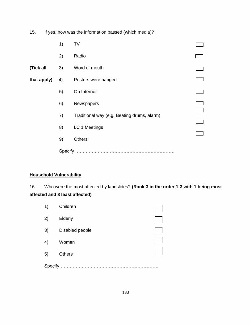
133
15. If yes, how was the information passed (which media)?
1) TV
2) Radio
(Tick all 3) Word of mouth
that apply) 4) Posters were hanged
5) On Internet
6) Newspapers
7) Traditional way (e.g. Beating drums, alarm)
8) LC 1 Meetings
9) Others
Specify …………………………………………………………
Household Vulnerability
16 Who were the most affected by landslides? (Rank 3 in the order 1-3 with 1 being most
affected and 3 least affected)
1) Children
2) Elderly
3) Disabled people
4) Women
5) Others
Specify…………………………………………………………

134
17. Why were they the most affected?
1) They were not aware
2) Location of their homes
(Tick all 3) Weak to run away
That apply) 4) Their number is big
5) Live in poor hour
6) They did not understand announcement/language
7) Many people live in the same house
8) Others
Specify…………………………………………………………
18. What visible environmental activities have led to increased risk of landslides?
1) Deforestation
2) Quarrying of stones
(Tick all 3) Dam building
that apply) 4) Road construction
5) Settlement on steep slopes
6) Increased rainfall
7) Increased population
8) Land fragmentation
9) Others
Specify …………………………………………………………

135
Household Coping
19. Is there a safe area where you escape or run to?
1) Yes
2) No
20. If Yes, where is that area?
1) Public school building
2) Neighbors or relatives
3) Public building/municipal hail
4) Church building
5) Private building
6) Others
Specify …………………………………………………
21. In the past 5 years have you and your household evacuated when there are landslides
or other natural disasters?
1) Yes
2) No
22. What methods do you use to reduce the effect of landslide disasters to your household
when they occur?
1) Borrow money (from friends, relatives, bank, money lenders)
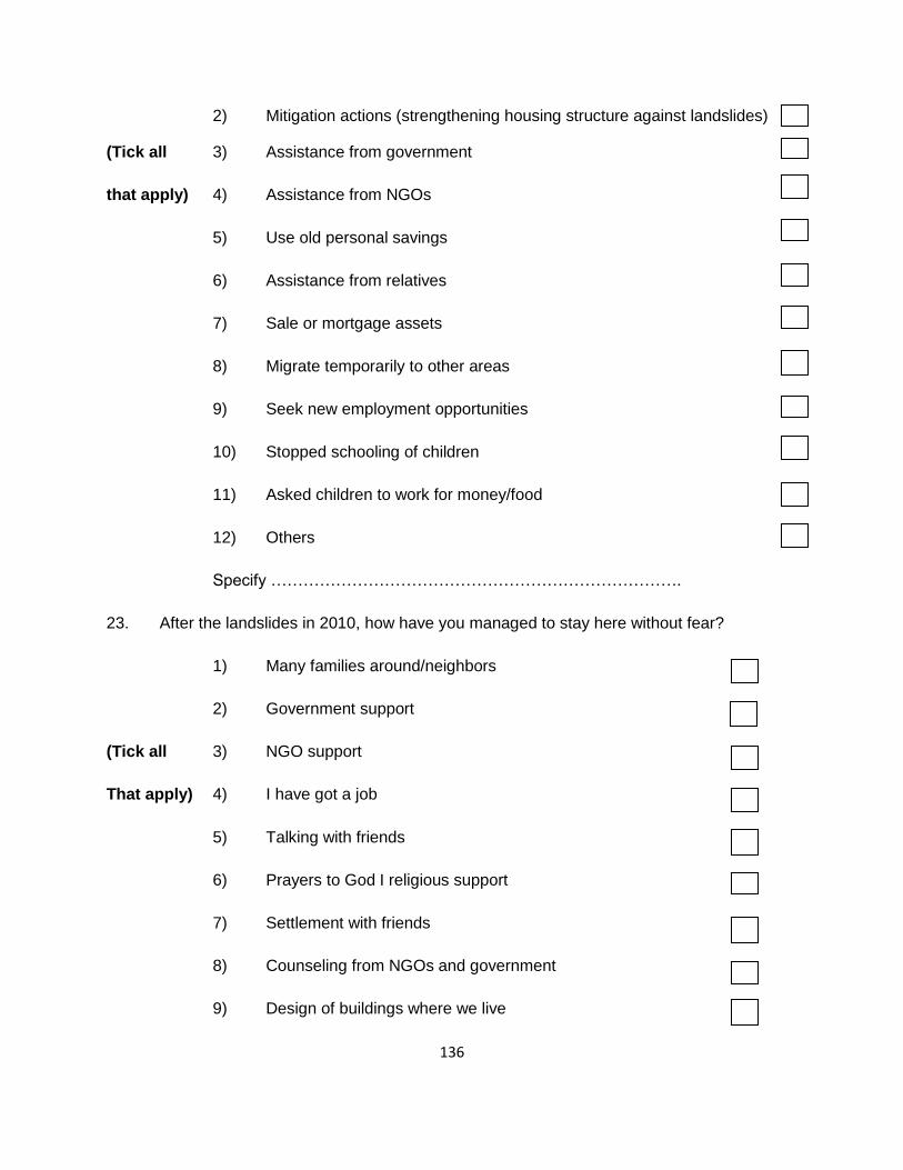
136
2) Mitigation actions (strengthening housing structure against landslides)
(Tick all 3) Assistance from government
that apply) 4) Assistance from NGOs
5) Use old personal savings
6) Assistance from relatives
7) Sale or mortgage assets
8) Migrate temporarily to other areas
9) Seek new employment opportunities
10) Stopped schooling of children
11) Asked children to work for money/food
12) Others
Specify ………………………………………………………………….
23. After the landslides in 2010, how have you managed to stay here without fear?
1) Many families around/neighbors
2) Government support
(Tick all 3) NGO support
That apply) 4) I have got a job
5) Talking with friends
6) Prayers to God I religious support
7) Settlement with friends
8) Counseling from NGOs and government
9) Design of buildings where we live

137
10) Relocation to other places
11) Others
Specify …………………………………………………………
Household Resilience
24. Did you attend any training on landslides management before the 2010 landslides
occurred?
1) Yes
2) No
25. If Yes, what information did you receive during the training/workshop?
1) Warning I alert signals
2) Evacuation routes and sites
(Tick all 3) Identification of hazards
that apply) 4) Identification of risky areas in the community
5) Others
Specify ………………………………………………………
26. Was the information you received useful during the landslide in 2010 and after?
1) Yes
2) No

138
27. Who provided the information / training?
1) Central government
2) Local government/district
3) NGOs and CBOs
4) Volunteer groups
5) Others
Specify …………………………………………………
28. What ways do you use to manage sudden shocks and stress caused by landslides?
1) Social support from friends
2) Support from family members
3) Community organizations (NGOs, CBOs)
4) Education/teachings provided
5) Counseling
6) Others
Specify………………………………………………………..
29. What do you think the government or NGOs should do to control landslides?
1) Provide seedlings for afforestation program
2) Conduct awareness campaign on causes and dangers of landslides
3) Provide building standards
4) Relocate settlement to safe areas

139
5) Introduce village house scheme
6) Others
Specify: ……………………………………………………
30. What steps are you taking to control landslides?
1) Planting trees (afforestation)
2) Avoiding cultivation on steep slopes
3) Relocating of settlements
4) Following proper building code
5) Building strong house foundation
6) Others
Specify ………………………………………………………….
THE END

140
APPENDIX B
KEY INFORMANTS (KI) INTERVIEW GUIDE
1. What do you think are the causes of landslides? Why?
2. How do you usually deal with landslide occurrences and the effects?
3. In which areas of life have landslides affected you?
4. How were you affected?
5. Why do you think your community was more affected than any other communities?
6. Were you able to tell that landslides would occur?
7. How did you know?
8. Who helped you to know?
9. Is there any way you are being prepared to deal with hazards
10. Who is preparing you?
11. Which relief organizations assisted you to deal with landslides?
12. Do you think relief organizations are important during disaster situations?
13. How and when do they usually help during landslides?
14. Do they ever seek your ideas before, during and after helping in disaster situations?
15. How do they usually do this?
16. Does the district have a disaster management committee?

141
APPENDIX C
APPROVAL BY THE UGANDA NATIONAL COUNCIL FOR SCIENCE AND
TECHNOLOGY

142
APPENDIX D
APPROVAL BY OFFICE OF THE PRESIDENT
Recommended