MASIPHUMELELE COMMUNITY RISK ASSESSMENT
April 2005
DMISA CONFERENCE
28 July 2005
Ameen Benjamin
Greg Nicolson
Disaster Risk Science University of Cape Town


Objectives of the risk assessment
• Identify hazards in Masiphumelele
• Identify the factors increasing vulnerability to priority hazards
• Present recommendations to reduce risk in Masiphumelele
• Develop a proposal for a ‘useful output’
Institutional arrangements
• Disaster Mitigation for Sustainable Livelihoods Programme (DiMP) coordinated the assessment as part of CRA course
• Disaster Risk Science honours students and Disaster managers from various municipalities in South Africa
• Local facilitators from Masiphumelele
• Local institutions from within the Cape Town Metropole
Community Risk Assessment Methods
1. Secondary data (qualitative and quantitative) which included: fire statistics from 1994 – 2004 and census data for 2001
2. Spatial data (aerial photographs, GPS)
3. Literature review (internet and library)

Participatory risk assessment methods
• Hazard Mapping
• Transect walk
• Concept Mapping
• Informal questionnaire
• Interviews : Community members & Institutions
Background to Masiphumelele
• 1950’s apartheid government declares the South Peninsula a white group area
• The government abolished influx control in 1986
• Families were forcibly removed in 1987
• Supreme court division granted squatters right to return in 1988
• Land Expropriated for the establishment of a township in 1990
• Masiphumelele established in 1992

• The settlement expanded rapidly from 191 dwellings in 1993 to 794 dwellings in 1996.
• 1268 sites were constructed between 1996 and 1998 at a high growth rate (gross) of 35% (per annum)
• Today there are considerably more dwellings and the population is an estimated 25 000.


Profile of Masiphumelele
• Most residents are originally from the Eastern Cape, seeking employment
• Status: +/-50% unemployed, 88.7% informal housing,
• Developmental priorities: Land and housing, schooling, health
• Services: electricity, toilets and standpipes


Disaster Risk Profile
• The assessment highlighted three priority disaster risks:
– Informal settlement fires
– Winter flooding/ponding
– Flood related illness such as cold and flu
• These disaster risks are inextricably linked
• Two areas in Masiphumelele were identified as at risk: The ‘Wetlands’ and ‘Schoolside’
• For this reason the assessment focused primarily in these areas and did not explore the risk in backyards and formal houses

Schoolside

Flooding risk in Masiphumelele

Flood Prone Informal Areas : April 2004


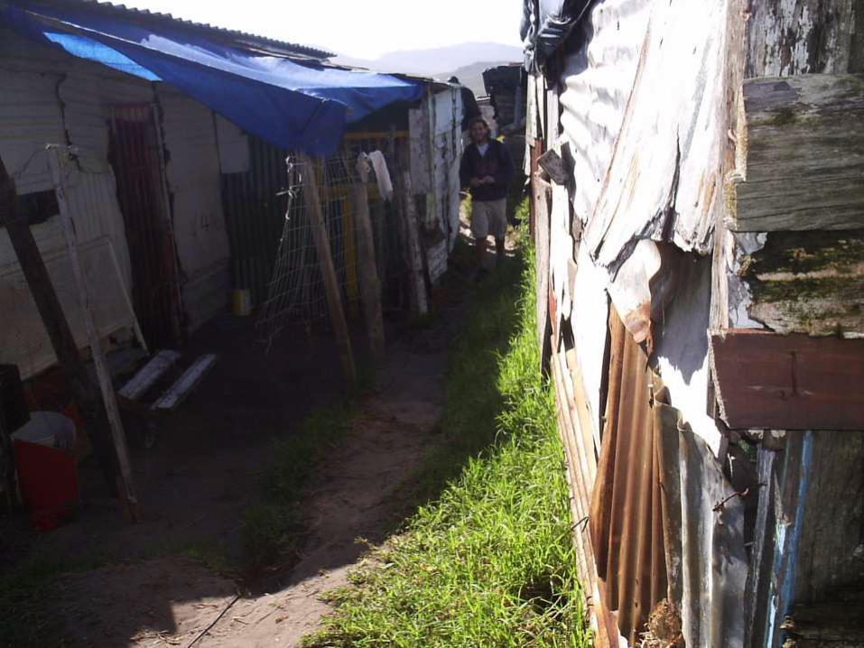

Informal dwelling fire risk in Masiphumelele

Figure 4: Number of fire incidents in Masiphumelele:
1994-2004
1
6
1 0
8 9
16 16
9
24
11
0
5
10
15
20
25
30
1994 1995 1996 1997 1998 1999 2000 2001 2002 2003 2004
No
. o
f in
cid
en
ts

Figure 5: Number of dwellings affeced by fire: 1994-
2004
115 12
021
8
61
30 28
203
156
0
50
100
150
200
250
1994 1995 1996 1997 1998 1999 2000 2001 2002 2003 2004
No
. o
f d
well
ing
s


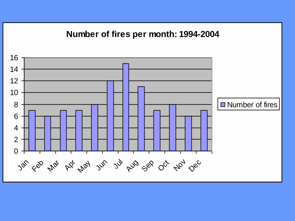
Number of fires per month: 1994-2004
0
2
4
6
8
10
12
14
16
Jan
Feb Mar A
pr
May Ju
nJu
lAug
Sep
Oct
Nov
Dec
Number of fires

Number of dwellings affected per month: 1994-2004
0
20
40
60
80
100
120
140Ja
n
Fe
b
Ma
r
Ap
r
Ma
y
Ju
n
Ju
l
Au
g
Se
p
Oct
No
v
De
c
Number of
dwellings
affected


Health risks in Masiphumelele High rate of TB and HIV/Aids
In Masiphumelele 24% of people tested are HIV positive
50% of TB patients are HIV positive
Living in wet damp conditions increases the risk of respiratory and other infections, such as flu/colds
Skin rashes were also identified – directly related to pollution
• insert photo of children

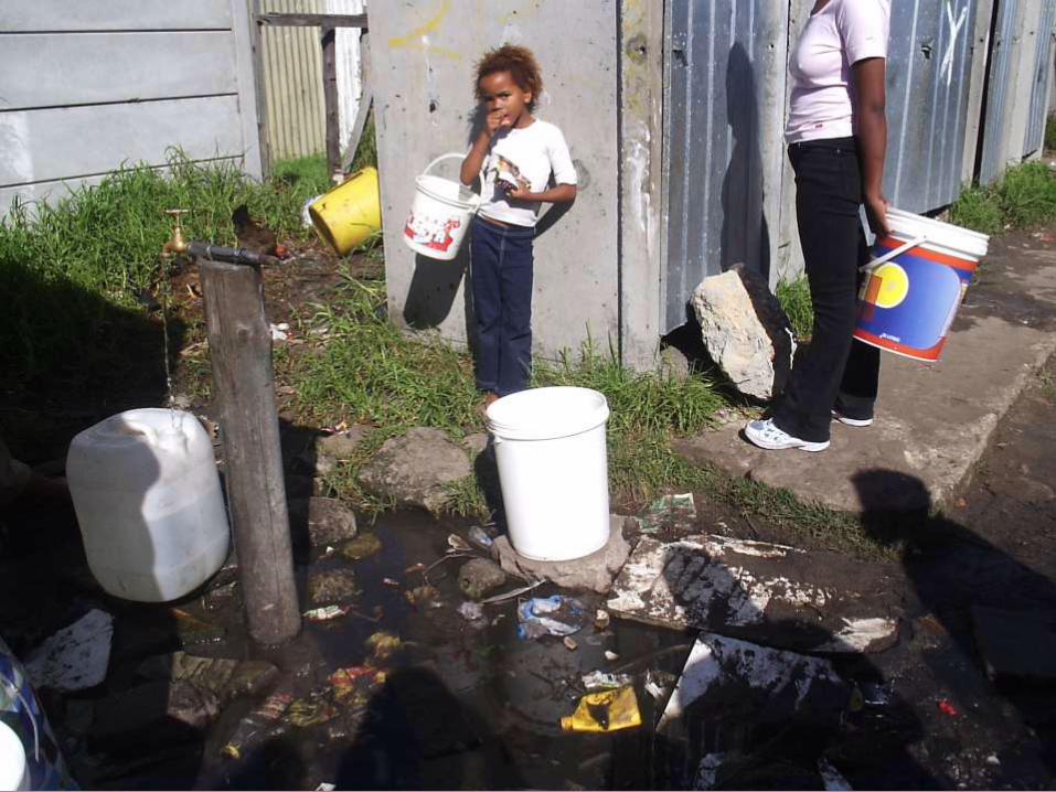


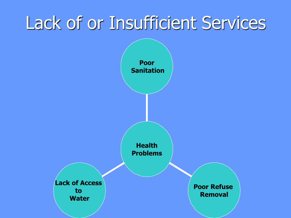
Lack of or Insufficient Services
Lack of Access to
Water
Poor Refuse Removal
Poor Sanitation
Health Problems

Community based risk reduction strategies
• Flood risk
– Building rubble
– Informal drains
– Cement floors
– Electricity supply is disconnected
• Fire risk
– Precautionary measures by parents
• Health risk
– Managing communal toilets by self-employed janitors

Multidimensional nature of disaster risk in Masiphumelele
• Disaster risks are multidimensional and interlinked
• In Masiphumelele disaster risk is not driven primarily by an external hazard, but by inherent conditions of vulnerability – which are a product of limited development – hence “development risk”
• Recommendations are therefore orientated towards not simply managing disaster emergencies, but to addressing the underlying factors/processes generating risk

Recommendations for Flooding Risk
• Clear indication of flood plain
• Clean storm water drains and channels
• Homes to be built up off the ground
• Control of new arrivals / construction
• Prioritise households with women and children with provision of plastic sheeting
Recommendations for Fire Risk
• Training of local fire fighting teams
• Improved access for fire services
• Fire hydrants / additional taps
• Provide fire-resistant recycled material for construction of houses
• Local policing of shebeens
• Education and awareness on fire prevention – especially for men

Recommendations for Health Risk
• Clear water bodies
• Regular waste removals
• Provide households with rubbish bins
• Better Health Services
• Sanitation
• Drainage
• Education Programmes
Specific Risk Reduction Recommendations
• Fast housing delivery on new land
• Secure more land for housing and ensure that the wetland is not encroached on
• Tackle underlying factors that increase vulnerability
• Provide sustainable employment

Proposed useful output
• Photo exhibition
– Mirror our experiences to residents and politicians
• Hazard exercise book
– Interactive way to teach children about risk
• Play
– Increase awareness about risk and empower people with skills
Recommended