NAVD 88 Helmert Orthometric Heights from NAD 83 GPS heights and the GEOID99 high resolution
geoid height model
Dru A. Smith, Ph.D. Daniel R. Roman, Ph.D.
National Geodetic Survey
Presented at the 2000 Meeting of the American Congress on Surveying and Mapping
Little Rock, Arkansas March 21, 2000

- Review of Height Systems
- Status of HARNS
- Creation of GEOID99 model
- Comparison with GEOID96
-Accuracy analysis of .. GPS leveling ..

h H
N
h=H+N
.. Ideal .. situation
Earth's Surface
GEOID
In the USA: N < 0

Real Situation
Earth's Surtace
-------------- - -------------------- ------------ N ~~~~~~~ --- -----
99 ----. ----~~~------ ......
, ----------_, __ _
,,- ', , ',
,, -------, ---_, --- -, __ , '
, ----
NAVDaa H::::o

STATUS of the HARNs
- 1998 : Last of original 48 CONUS HARNs
NGS begins FBNVC (FBN Vertical Component)
- 1999 : Wisconsin FBNVC observed, processed, loaded into NGSIDB
Washington and Oregon FBNVC observed and preliminarily processed. Not loaded into NGSIDB.
GEOID99 released, reflecting 45 original HARNs and 3 FBNVC states (WI, WA, OR)

GPS/BMs for GEOID99 (6169 points)
-126.0 -96.0 -66.0 so.o~~~~~~~~~~~~~~~~~~~~~~~~~~~~~~~~~so.o
+
Q)
"C :::s ... 37.0 37.0 ..... "' ...J
24.o~~~TTTIII~rr~TTII~rr~TT~,.~~~~,.~rriiTTII~rrll~~~~24.0
-126.0 -96.0 -66.0
Longitude

Differences 50 N
40 N
30 N
230 E 240 E 250 E 260 E 270 E Long itude
-·.. : • ..;1 - • ~-
.. . - -. : "'7 .. ~
- 0 .10 - 0.05 0 .00 meters
280 E 290 E 300 E
0 .05 0 .10

GEOID99 basic information
!nPY! data - 2.0 Million gravity observations (1.6 from
the NIMA evaluated gravity database) - 0.6 Million altimetric gravity anomalies - EGM96 (NASAINIMA) - 1 km OEM supplemented by
30m OEM in Northwest USA - 6169 GPS heights on leveled benchmarks
Theory - Faye anomalies ,..., Helmert anomalies - Remove/Compute/Restore using EGM96
and 1-0 FFT - Collocation to model h-H-N long
wavelength systematic differences
OutpY! Grids - 1 arc-minute grids - CONUS: up to 58 degrees North - Alaska, Hawaii, Puerto RicoNirgin Islands

30 meter OEM in Northwest USA
-USGS makes 30 meter DEMs available in 7.5 minute quadrangular areas on UTM grid
- NGS acquired, cleaned, and regridded the data onto 1 arcsecond grid in the region 39/49 North and 231/256 East (NGSDEM99)
- Decimated 3 arcsecond OEM used for terrain corrections
- Geoid impact of new OEM in Northwest USA: -14 em (1 cr) locally (max +1- 40 em) -7 ppm tilts (1 cr) {max +1- 200 ppm)


(j)
u ::J
-I-'
50 N
c; 40 N _j
30 N
230 E
-50
240 E 250 E
- 40
GEOID99
260 E 270 E Long itude
- 30 meters
280 E 290 E 300 E
- 20 -1 0

50 N
~ 40 N :J
..........
.......... 0 -'
30 N
230 E
- 0.20
240 E
Dif ferences bet ween GEOID99 and GEOID96
250 E
- 0 .10
260 E Long itude
0.00 meters
270 E 280 E
0 .10
290 E
0.20
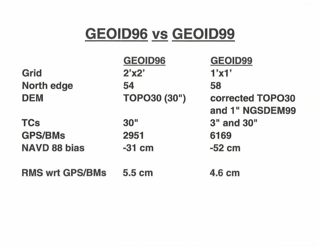
GEOID96 vs GEOID99
GEOID96 GEOID99 Grid 2'x2' 1 'x1' North edge 54 58 OEM TOP030 (3011
) corrected TOP030 and 111 NGSDEM99
TCs 3011 3 11 and 30 11
GPS/BMs 2951 6169 NAVD 88 bias -31 em -52 em
RMS wrt GPS/BMs 5.5 em 4.6 em

c 0
-+-' 0
·::; Q)
a "0 '-0 "0 c 0
-+-' (/)
+ I
I I
tt+
Em irical Standard Deviation for ee_ 1 km
+ + + +
+++ + -t+ + +
+ + +
+ +
-1--- ----- -- - ---- -- ------- - -- --- -~------------------1
+
+
0 20 40 Distance (km)
+
60 80
+ + +
100

9
8
7
L
2 5 L w "D 4 L
0 "D
§ 3 ....... (J)
2
1
+ +
Standard Deviation of differential (h-N)
X
Xx X X X X XXXX X XX X X X X XXX X X X XxXX X X xxXXX X xX~ XX X X X XX X xX X
Xx X X X X X X
X
X
A
8
+ + + + +
+ + + + + + + + c
+ +
D
E
20 40 60 80 100
Point spacing (km )

DIFFERENTIAL {SINGLE TIE} GPS-DERIVED ORTHOMETRIC HEIGHT ACCURACY
LINE Description 5 km lines --()(ppm)
A GEOID96 6.7 em (13 ppm)
8 GEOID99 5.2 em (1 0 ppm)
c GEOID99* (WA,OR,WI) 4.7 em (9.4 ppm)
D GEOID Error only? 0.8 em (1.6 ppm)
E 2nd order, class II 0.3 em (0.6 ppm)
1Q km lines cr (ppm)
6.9 em (6.9 ppm)
5.5 em (5.5 ppm)
4.1 em (4.1 ppm)
1.6 em (1.6 ppm)
0.4 em (0.4 ppm)
* = Experimental solution taylored to the 1 em (1 cr) GPS in these states

DIFFERENTIAL GPS-DERIVED ORTHOMETRIC HEIGHT ACCURACY
cr can be reduced through;_
- Multiple ties (4 ties = half the cr of a single tie)
- Better knowledge of the geoid (i.e. Baltimore county)
Local ( <5 km) cr .!§ hard !Q know due !Q lack .Qf §pecial studies

pairs.0.0-0.5km.latlon
-130.0 -98.0 -66.0 so . o ~~~~~~~~~~~~~~~~~~~~~~~~~~~~~~~~~~so.o
+
++ +
+ +
+ + +
Q)
'0 + :::J + ..... 37. 0 37.0 ..... as ...J
+
+ ++
+ + +
24 . 0 ~~~~~~~~~~~~~~~~~~~~~~~~~~~~~~~~~~24.0
-130.0 -98.0 -66.0
Longitude

\....
0 \.... \.... w \J \....
0 \J c 0 ..._,
(/)
Standard Deviation of d.ff . I erentlal (h-N)
A
B
+ + + + + + +
+ + + + + + + c
+ + + +
D II' .
~~~'~~ - F
1
(!) (!) tl. 4i. (!)
Ali. Ali.
All. A ••••••••••••••••••••••••••••••••••••••••••••••••••••••••••••••••••••••••••••••••••••• E At:.
A o ooooooooo o 0 oO
0~0 ----~--~----~--~-----v 20 40 60 80 100
Point spacing (km)

CONCLUSIONS
- GEOID99 has 4.6 em RMS absolute agreement with GPS/BM (GEOID96 was 5.5 em)
-Short lines(< 5 km) are hard to evaluate due to lack of data
-Medium lines (5-40 km) are 4-10 ppm with single-ties
-Longer lines (40+ km) may be influenced by leveling error
- Establishing NAVD 88 heights from GEOID99 and GPS can be improved if multiple ties are used and the geoid is better known

GEOID99 Availability
WWW (Sept. 30): http://www.ngs.noaa.gov/GEOID/geoid99.html
CD-ROM (Mid-October): Information Services Branch NOAA/National Geodetic Survey, N/NGS12 1315 East-West Highway, Station 9202 Silver Spring, MD 20910-3282 voice: 301-713-3242 fax: 301-713-4172
Recommended