1NATIONAL WEATHER SERVICEProtecting Lives and Property for 150 Years Building a Weather-Ready Nation //
NATIONAL WEATHER SERVICE Protecting Lives and Property for 150 Years
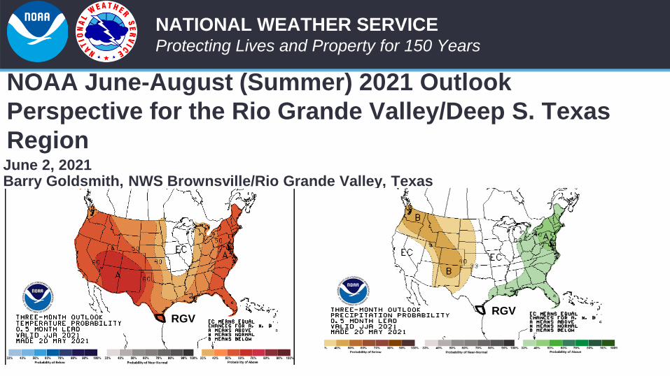
NOAA June-August (Summer) 2021 Outlook
Perspective for the Rio Grande Valley/Deep S. Texas
RegionJune 2, 2021Barry Goldsmith, NWS Brownsville/Rio Grande Valley, Texas
RGVRGV
2NATIONAL WEATHER SERVICEProtecting Lives and Property for 150 Years Building a Weather-Ready Nation //
Key Takeaways• Change in Pattern? Summer (June) starting wet, but will “La Canícula” return in force
by July?
• Uncertainty high, confidence low in the seasonal forecast
• Predictive Difficulty a combination of sharp change in pattern during May (into early June), followed by usual uncertainty in the start of peak hurricane season (August).
• Drought is “out” through June, but dryness and low-end drought could resume in July and August
• Dangerous “feels like” temperatures could reach/exceed 110˚F frequently in July and August
• Municipal and Agricultural water supplies have been given a reprieve by “Top Ten” May rainfall and a wet start to June…
• …but Falcon Reservoir remains low to begin summer, even with some pool rises compared with late April low points
• Could 2021 provide the *fourth* consecutive flood event in late June or July? Impossible to predict specifics of late June/July pattern development.
3NATIONAL WEATHER SERVICEProtecting Lives and Property for 150 Years Building a Weather-Ready Nation //
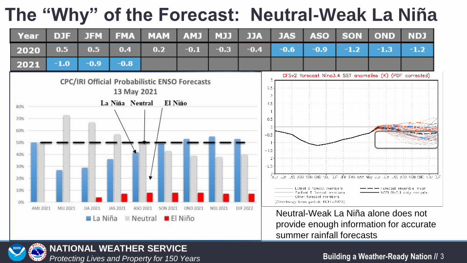
The “Why” of the Forecast: Neutral-Weak La Niña
Neutral-Weak La Niña alone does not
provide enough information for accurate
summer rainfall forecasts
4NATIONAL WEATHER SERVICEProtecting Lives and Property for 150 Years Building a Weather-Ready Nation //
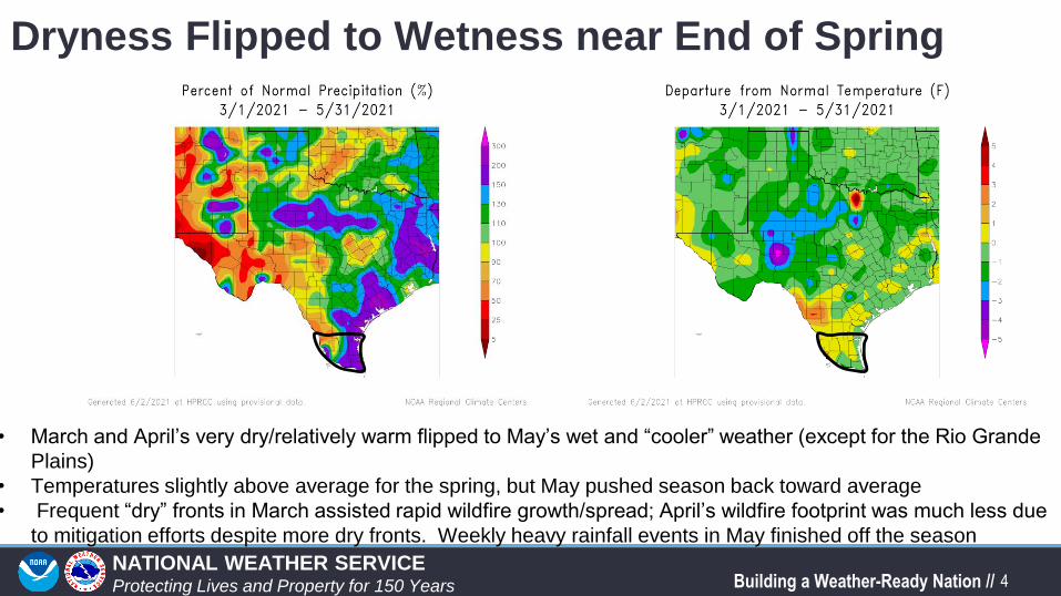
Dryness Flipped to Wetness near End of Spring
• March and April’s very dry/relatively warm flipped to May’s wet and “cooler” weather (except for the Rio Grande
Plains)
• Temperatures slightly above average for the spring, but May pushed season back toward average
• Frequent “dry” fronts in March assisted rapid wildfire growth/spread; April’s wildfire footprint was much less due
to mitigation efforts despite more dry fronts. Weekly heavy rainfall events in May finished off the season
5NATIONAL WEATHER SERVICEProtecting Lives and Property for 150 Years Building a Weather-Ready Nation //
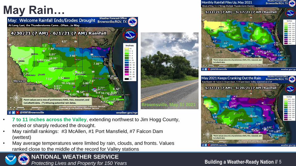
May Rain…
• 7 to 11 inches across the Valley, extending northwest to Jim Hogg County,
ended or sharply reduced the drought.
• May rainfall rankings: #3 McAllen, #1 Port Mansfield, #7 Falcon Dam
(wettest)
• May average temperatures were limited by rain, clouds, and fronts. Values
ranked close to the middle of the record for Valley stations
Brownsville, May 31 2021
6NATIONAL WEATHER SERVICEProtecting Lives and Property for 150 Years Building a Weather-Ready Nation //
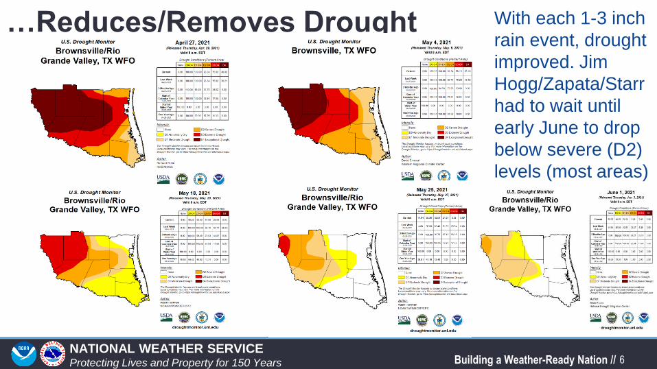
…Reduces/Removes Drought With each 1-3 inch
rain event, drought
improved. Jim
Hogg/Zapata/Starr
had to wait until
early June to drop
below severe (D2)
levels (most areas)
7NATIONAL WEATHER SERVICEProtecting Lives and Property for 150 Years Building a Weather-Ready Nation //
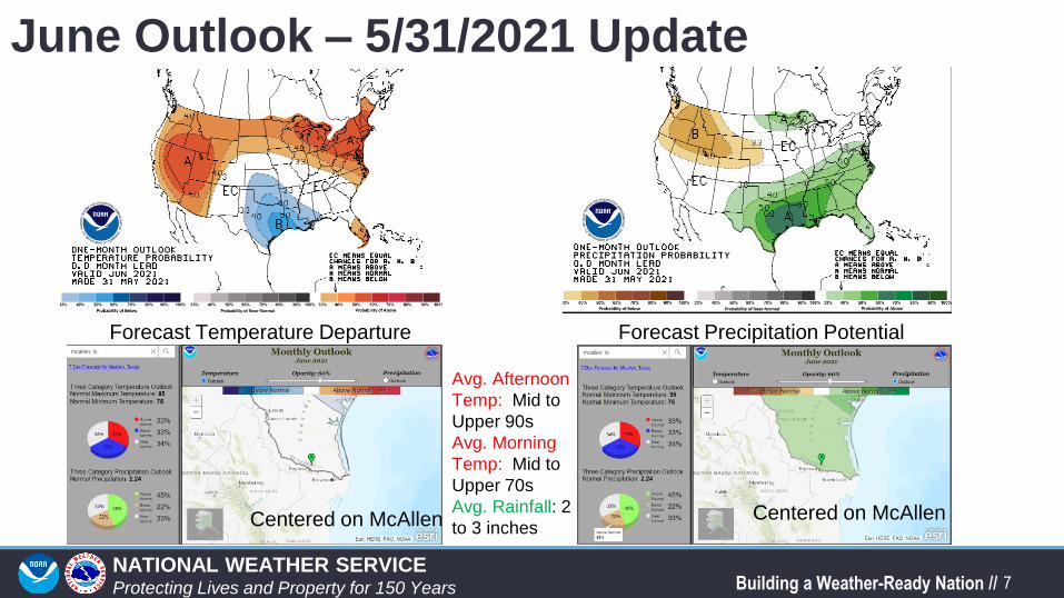
June Outlook – 5/31/2021 Update
Forecast Temperature Departure Forecast Precipitation Potential
Centered on McAllen Centered on McAllen
Avg. Afternoon
Temp: Mid to
Upper 90s
Avg. Morning
Temp: Mid to
Upper 70s
Avg. Rainfall: 2
to 3 inches
8NATIONAL WEATHER SERVICEProtecting Lives and Property for 150 Years Building a Weather-Ready Nation //
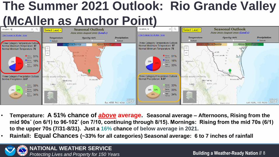
The Summer 2021 Outlook: Rio Grande Valley
(McAllen as Anchor Point)
• Temperature: A 51% chance of above average. Seasonal average – Afternoons, Rising from the
mid 90s˚ (on 6/1) to 96-102˚ (on 7/10, continuing through 8/15). Mornings: Rising from the mid 70s (6/1)
to the upper 70s (7/31-8/31). Just a 16% chance of below average in 2021.
• Rainfall: Equal Chances (~33% for all categories) Seasonal average: 6 to 7 inches of rainfall
11NATIONAL WEATHER SERVICEProtecting Lives and Property for 150 Years Building a Weather-Ready Nation //
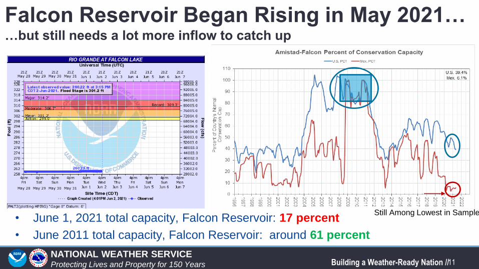
Falcon Reservoir Began Rising in May 2021……but still needs a lot more inflow to catch up
• June 1, 2021 total capacity, Falcon Reservoir: 17 percent
• June 2011 total capacity, Falcon Reservoir: around 61 percent
Still Among Lowest in Sample
14NATIONAL WEATHER SERVICEProtecting Lives and Property for 150 Years Building a Weather-Ready Nation //
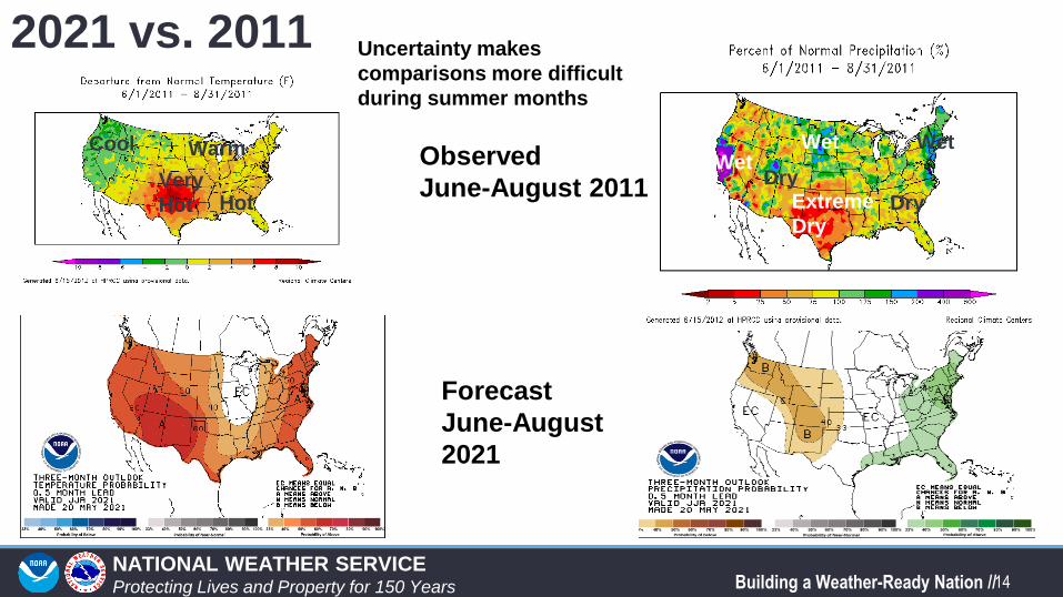
2021 vs. 2011
Observed
June-August 2011
Forecast
June-August
2021
Wet
Extreme
Dry
Wet
Hot
Warm
Very
Hot
CoolWet
Dry
Uncertainty makes
comparisons more difficult
during summer months
Dry
15NATIONAL WEATHER SERVICEProtecting Lives and Property for 150 Years Building a Weather-Ready Nation //
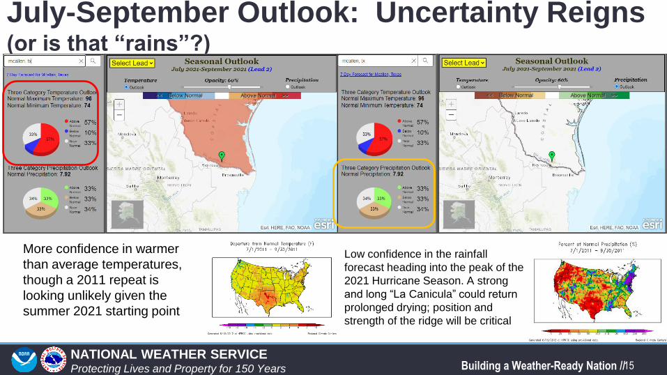
July-September Outlook: Uncertainty Reigns (or is that “rains”?)
More confidence in warmer
than average temperatures,
though a 2011 repeat is
looking unlikely given the
summer 2021 starting point
Low confidence in the rainfall
forecast heading into the peak of the
2021 Hurricane Season. A strong
and long “La Canicula” could return
prolonged drying; position and
strength of the ridge will be critical
16NATIONAL WEATHER SERVICEProtecting Lives and Property for 150 Years Building a Weather-Ready Nation //
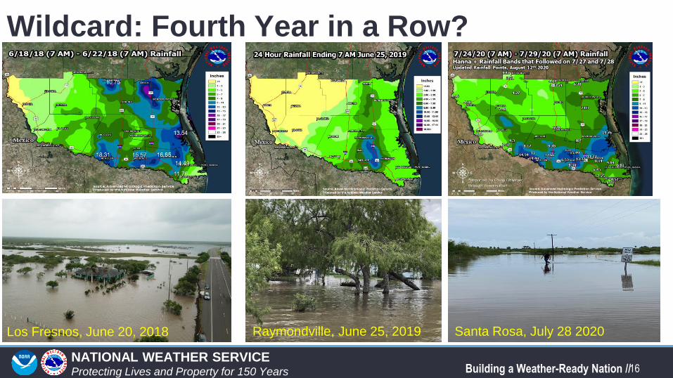
Wildcard: Fourth Year in a Row?
Los Fresnos, June 20, 2018 Raymondville, June 25, 2019 Santa Rosa, July 28 2020
17NATIONAL WEATHER SERVICEProtecting Lives and Property for 150 Years Building a Weather-Ready Nation //
In Summary: Impacts and Actions• Very wet and relatively cool weather in May and early June have temporarily
removed drought and wildfire spread threat from the discussion
• However, the potential remains for a rapid onset of “La Canícula” (Dog Days) conditions by late June, which could continue for much of summer
• Should La Canícula establish itself, benefits from May/June rainfall would be gone, and dryness/drought would resume in July and August. This could create a future wildfire growth/spread situation (late summer/autumn) given fuel “loading” from the May/June growth
• Should the upper ridge settle farther west, the door would open for an occasional influx of deep tropical moisture, particularly in August. Unknown is what the tropics might do along the Texas/northeast Mexico coast.
• Bottom lines? Prepare equally for the following:• Dangerous summer heat (“feels like” temperatures 110+) at times, especially from late June through mid
August
• Flooding rains, from tropical waves to potential cyclones (depressions to hurricanes)
• Wildfire spread, should fuels dry out in mid summer heat and humidity/winds combine to enhance growth rates.
Recommended