Northeast Arkansas District Forestry Contest
Forestry Contest • The forestry contest consist of five different areas.• The contest takes about 2 ½ hours to finish with five
minute break between every area. • The team with the most points winning the contest.• There shall be a minimum of three members of a four
member team.• Participants can not touch or handle the forestry
materials.• All participants shall be given a ID number.• All participants must provide their own equipment
and the written material will be furnished.• All contestants must dress appropriately due to the
contest being held outside.
Forestry Contest Consist:
• 1. Tree Identification – offered every year• 2. Equipment Identification – offered every year• 3. Tree Measurement. (Either Saw Logs or
Pulpwood)• 4. Two of the following
– Timber Stand Improvement (TSI)
– Map Reading
– Compass Reading
– Tree Disorders -- Will not be used In 2001
– Forest Products -- Will be used in 2002
Tree Identification
• Tree Identification:– Twenty (20) trees will be identified from the
event list– Contestants will have 30 minutes to complete
this section.– This part of the contest is offered every year.
Tree Identification: Scoring
• Scoring (Form 15B)– Each participant will be allowed 30 minutes to
complete the area – Two minutes for viewing each specimen– Five (5) points will be awarded for each of the
twenty trees correctly identified for a maximum of 100 Points.
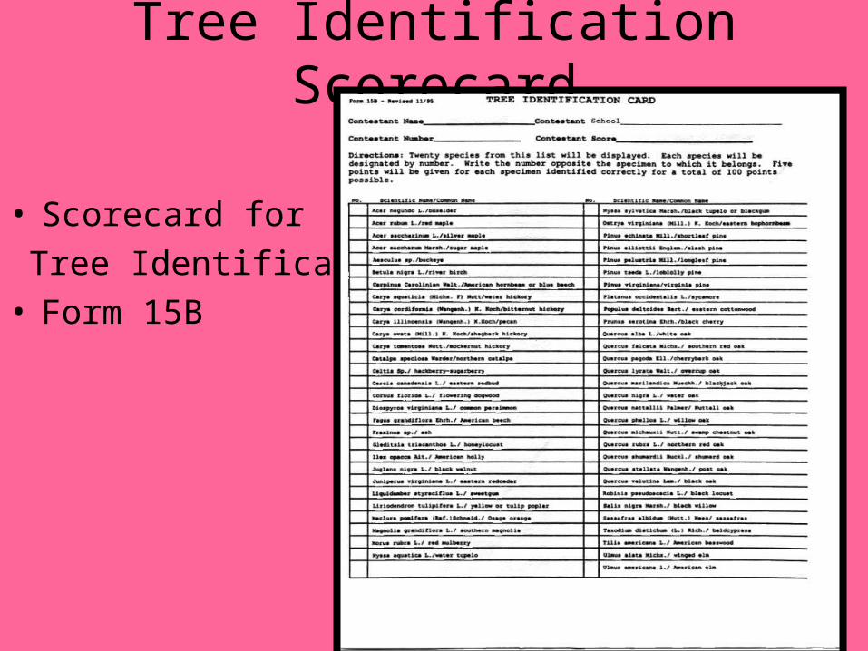
Tree Identification Scorecard
• Scorecard for
Tree Identification• Form 15B
Equipment Identification
• Twenty pieces of equipment will be displayed for participants to identify by technical names
• Each piece of equipment will be designated my number
• Each participant will have 30 minutes to complete
Equipment Identification: Scoring
• Score (Form 24)– Each participant will be 30 minutes to complete
this area.– Three points will be give for each piece of
equipment identified for a total of 60 points– No partial credit given
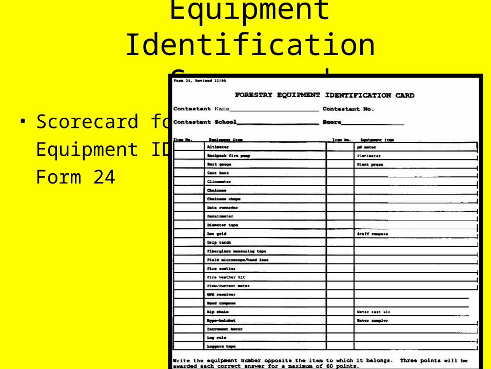
Equipment Identification Scorecard
• Scorecard for
Equipment ID
Form 24
Tree Measurement• Cord Volume
– Using forest measuring tools measure pre-numbered standing trees on a fractional acre plot for cord volume
– Contestants will use tree scale to stick measure tree height and diameter
– Participant must record DBH (Diameter Breast Height) and will be rounded down to the nearest 4’ stick.
– DBH will be rounded to nearest inch
– Must convert the volume to one-acre basis
– Example• Pulp
Tree Measurement, cont..
• Board Volume - Timber Cruising– Using forest measuring tools measure pre-numbered
standing trees on a fractional acre plot for board foot volume
– DBH will be rounded to nearest inch
– Merchantable height to rounded down to nearest 8’ log
– Must convert the volume to one-acre basis.
Example:
– Saw Logs
Tree Measurement: Scoring
• Scoring for Board Volume and Cord Volume (Forms 17 and 18)– Three points for correct DBH – Three points for correct height.– Forty points for correct volume per acre– Five points will be deducted for 5 % plus or
minus from the correct measured volume
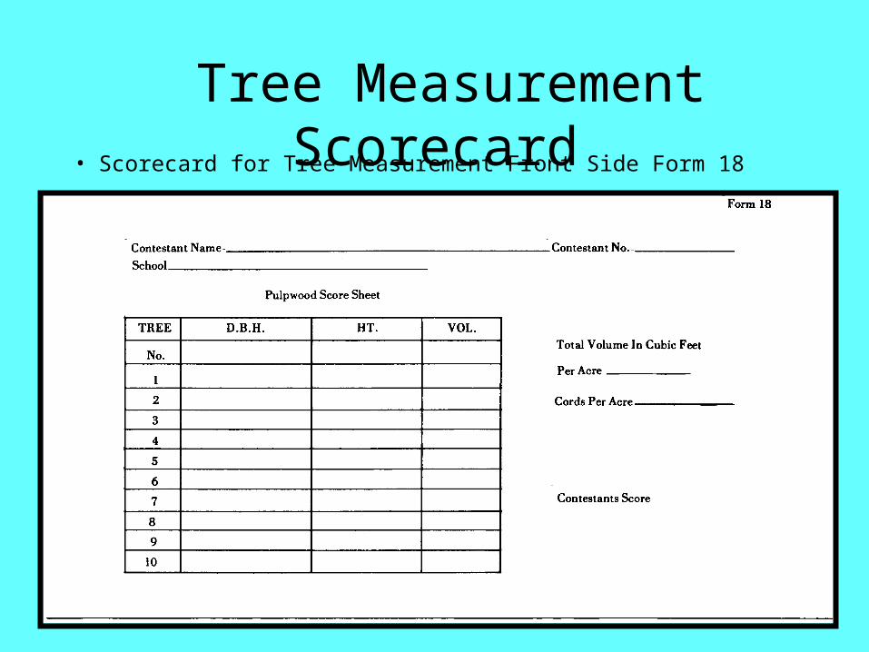
Tree Measurement Scorecard• Scorecard for Tree Measurement Front Side Form 18
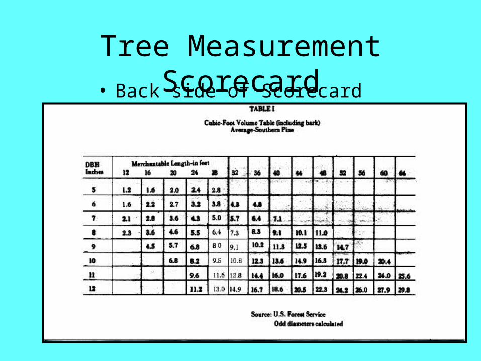
Tree Measurement Scorecard• Back side of Scorecard for Pulpwood
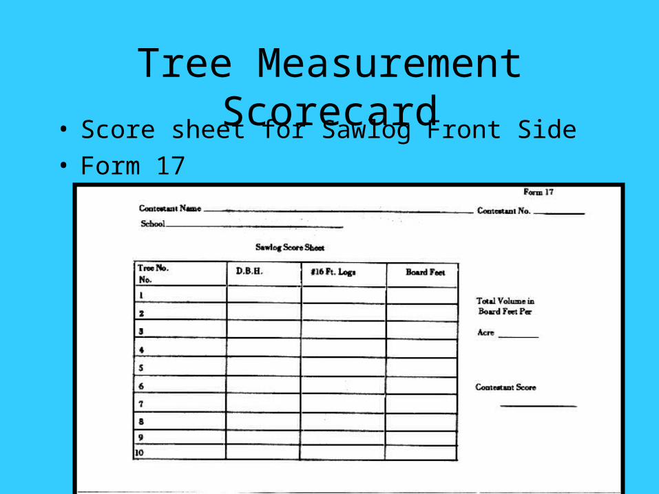
Tree Measurement Scorecard• Score sheet for Sawlog Front Side• Form 17
Tree Measurement Scorecard
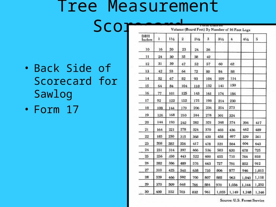
• Back Side of Scorecard for Sawlog
• Form 17
Timber Stand Improvement (TSI):
• 1. The trees selected may be all one specie or a mixture of species.
• 2. An area will be selected and marked by paint, ribbon or other methods. It will contain 15 to 25 trees (usually 20) marked that needs to be cut, deaden, or leave.
• 3. All trees in the designated area will be considered as a forest management site and each marked tree will be scored by the contestant using one of the following options:
Timber Stand Improvement(TSI): Cont….
– A. Harvest (utilize tree) – B. Leave (tree should remain in stand) – C. Deaden (undesirable, non-merchantable, or non-
beneficial to wildlife, deaden or cut and leave in the woods.
• 4. The contestants will be given a "situation" concerning the management objective of the site. Information needed to help participants include:– A. Markets available – B. Wildlife habitat – C. Present condition of stand – D. Final Goal of management plan
Timber Stand Improvement (TSI): Cont…..
• This information will be provided at the site before the contestants begin the practicum. The information may be presented orally, by poster or via handout.
(TSI): Scoring
• Scoring (Form 16)– Four points will be awarded for each correct
answer up to a maximum of 100 points.– Thirty (30) minutes will be allowed for this
exercise.
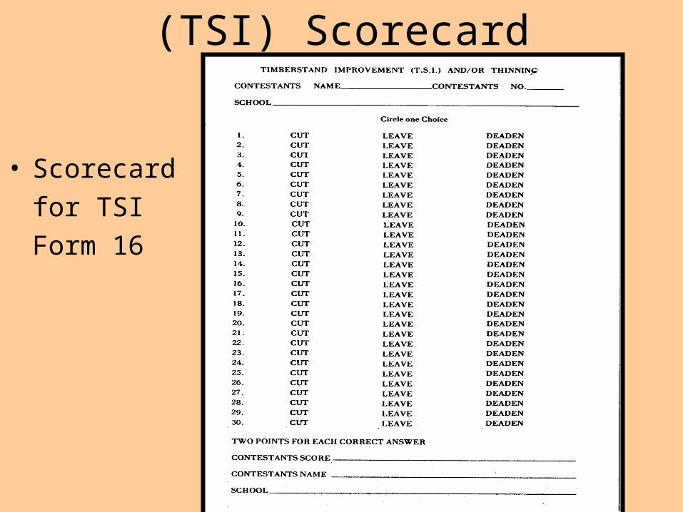
(TSI) Scorecard
• Scorecard
for TSI
Form 16
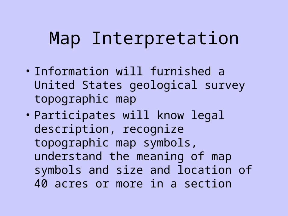
Map Interpretation
• Information will furnished a United States geological survey topographic map
• Participates will know legal description, recognize topographic map symbols, understand the meaning of map symbols and size and location of 40 acres or more in a section
Map Interpretation: Scoring
• Scoring (Form 23)– Ten questions or problems will be offered and
completed. – Ten points will be awarded for each correct
answer for a total of 100 points.
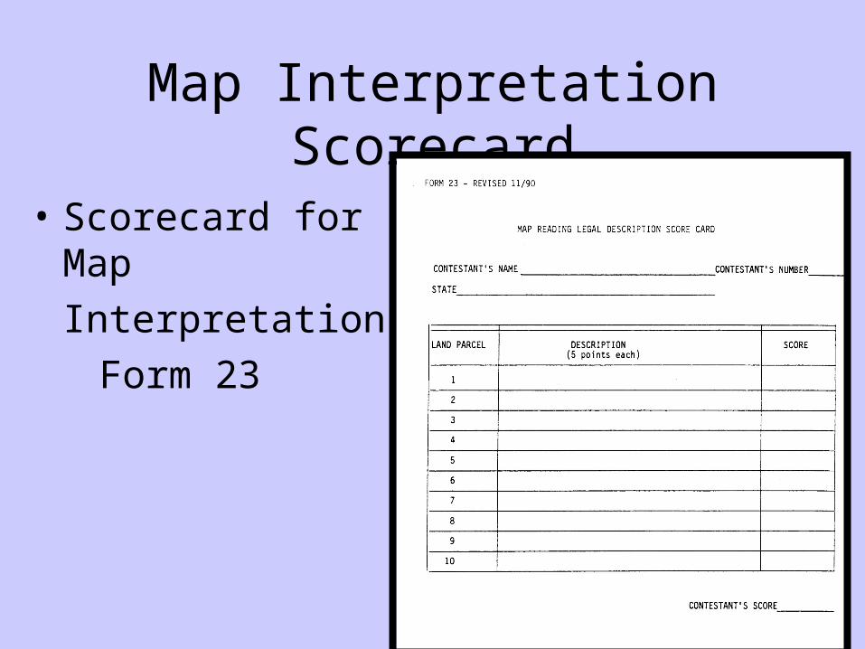
Map Interpretation Scorecard
• Scorecard for Map
Interpretation
Form 23
Compass Reading:
• Participant will use a hand compass to determine property lines to the nearest foot on a tract of timber
• The course will have ten marked points.
• Participant will start at any point and record compass readings.
• Azimuth readings shall be recorded.
Compass Reading: Scoring
• Scoring (Form 22)– A total of 100 points are possible.– Ten points for numbered site– Five points for correct azimuth – Five points for correct distance
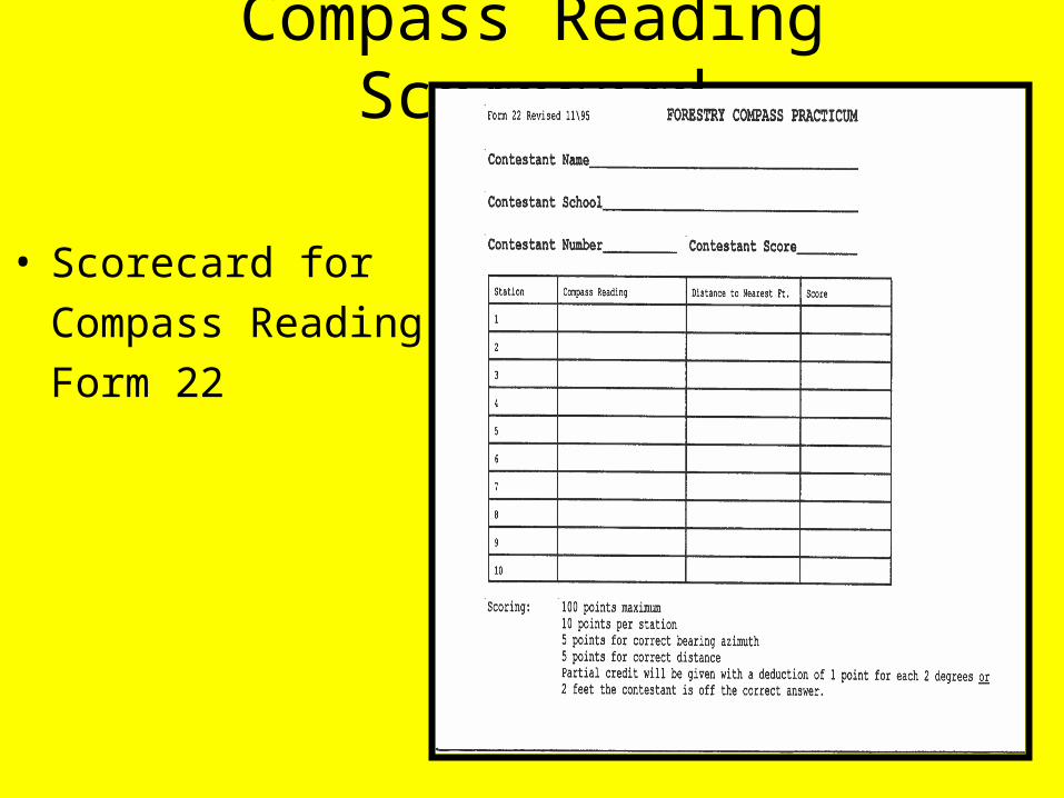
Compass Reading Scorecard
• Scorecard for
Compass Reading
Form 22
Tree Disorder:
• Symptoms of at least 10, nor more than 20 disorders from the list.
• Symptoms will be presented in one or more of the following forms– Actual Sample– Pictures/Slides– Written description– Written case history
Tree Disorder: Scoring
• Scoring (Unofficial Form FYTD-1)– Five points for each disorder will be awarded
for up to 100 points.
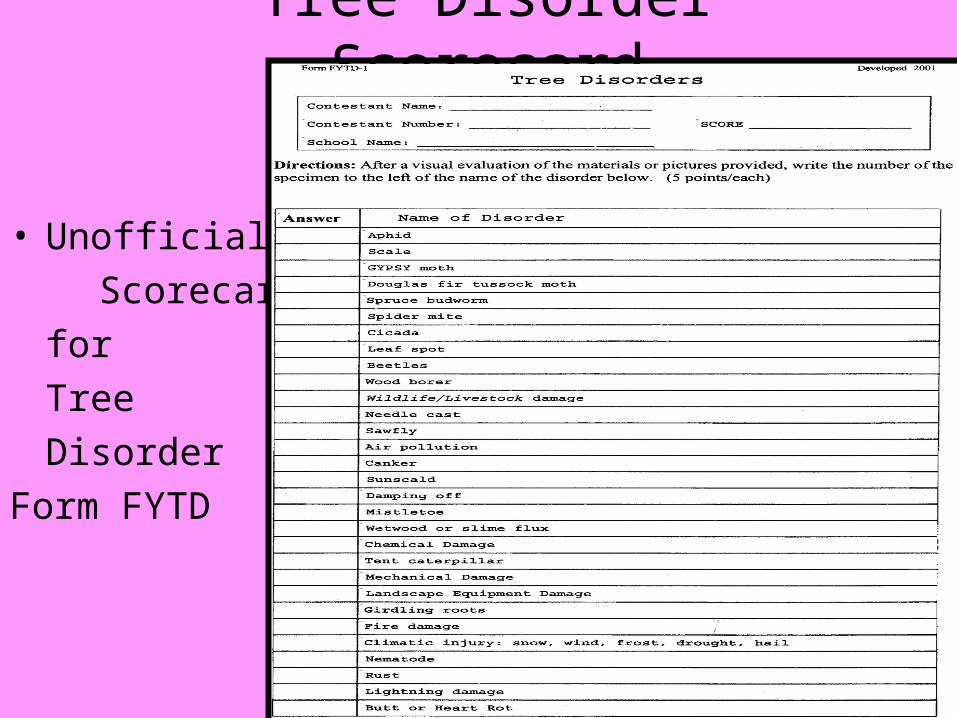
Tree Disorder Scorecard
• Unofficial
Scorecard
for
Tree
Disorder
Form FYTD
Forest Products:
• Ten to Twenty wood products/samples will be displayed for participates
• They will determine the source tree for each item.
• Source will be one of the trees from the tree id card.
Forest Products: Scoring
• Scoring – Multiple choice exam– Five points for wood product for a total of 100
points.
Forest Products Scorecard
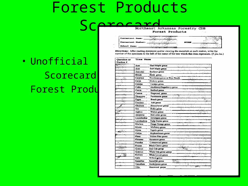
• Unofficial
Scorecard for
Forest Products
Forestry Contest
• Aids to stimulate student interest in the forestry project
• Main objectives– To understand and use forestry terms
– Ability to recognize multiple use opportunities in the forest
– Ability to recognize environmental and social factors
– Ability to identify major species of trees of economic importance to the U.S.
Recommended