Volume 3 No. 3, March 2013 ISSN 2223-4985
International Journal of Information and Communication Technology Research
©2013 ICT Journal. All rights reserved
http://www.esjournals.org
102
Online Map Application Development Using Google Maps API,
SQL Database, and ASP.NET
1 Shunfu Hu, 2 Ting Dai 1 Department of Geography, Southern Illinois University Edwardsville, Edwardsville, IL 62026, USA
2 Farm Service Agency, Unites States Department of Agriculture, Washington, DC 20250, USA
ABSTRACT
Recently, there has seen increasing interest in developing online map services using Google Maps Application Programming
Interface (API), Yahoo! Maps API, Microsoft Bing Maps API, Nokia Ovi Maps API, and ESRI ArcGIS API. Application developers
utilize Maps API as a platform and combine spatial data from multiple sources to create new customized services – a buzzword
commonly called map “mashups”. The use of Maps API has revolutionized online mapping applications on the Internet. However,
there are two major drawbacks in the map “mashups”. First, the application developer utilizes open source methods such as XML,
Fusion Tables, CSV, or KML for the preparation of limited amount of usually non-secured spatial data, which are not suitable for
data sources in the format of a commercial database stored on a secure data server. Second, map “mashups” is focused on the use of
the Maps API platform for the fast delivery of the customized services or data, so they usually lack of sophisticated functionalities
and intuitive user interfaces that can offer the user the capability to manipulate the data. The objective of this paper is to demonstrate
an online mapping application that requires the access to data sources in the format of a commercial database stored on a secure data
server and that offers sophisticated functionalities for the user to manipulate the data. A case study of developing an online map
service to display tens of thousands gardens on the Internet for the United States Department of Agriculture (USDA) People's
Garden Initiative is presented. Google Maps API, Google Geocoderer, Microsoft SQL database, Microsoft aspx.NET, and Spry
Framework for Ajax are employed to develop this online map application. It is also anticipated that the online map application can
be used in major web browsers such as Microsoft Internet Explorer (IE) 7.0+, Google Chrome, Mozilla Firefox, and Apple Safari.
Keywords: Online Mapping, Google Maps API, SQL Database, ASP.NET, USDA
1. INTRODUCTION
The Google Maps launched in 2005 has revolutionized online
mapping service applications on the World Wide Web. Based
on Asynchronous JavaScript and XML (AJAX), a new type of
client/server interaction was introduced in Google Maps to
maintain a continuous connection between the client and the
server for immediate downloading of additional map
information [1]. In addition, Google also provides programmers
its extensive sources of code called the Application
Programming Interface (API). The API consists of a set of data
structures, object classes or functions that can be used by a
programmer using JavaScript, PHP or other scripting language
[2]. With the current version 3, it is not required to register the
API key to use the Google Maps. The new version supports
both traditional web browsers such as Internet Explorer 7.0+,
Firefox 3.0+, Safari 4+, Chrome, Android, BlackBerry, and
Dolfin as well as web browsers such as the Apple iPad and
iPhone on mobile devices. all of which having a full JavaScript
implementation. These features make Google Maps JavaScript
API the most commonly used Maps API for online mapping
[3]. Other Maps APIs are also available for online mapping,
including Yahoo! Maps API, Microsoft Bing Maps API, Nokia
Ovi Maps API, and ESRI ArcGIS API.
Recently there has seen increasing interest in utilizing Google
Maps API to implement web-based mapping services, ranging
from simple applications to display just a few points of interest
with information window to sophisticated map mashups [4] [5]
[6] [7] [8]. Scholefield [9] developed a web-based map service
for tourism of eighteenth and nineteenth century Edinburgh
using Google Map API, Oracle RDMS (Relational Database
Management System), Microsoft SQL (Structured Query
Language), Perl, eXtensible Markup Language (XML),
JavaScript, Hypertext Markup Language (HTML), eXtensible
HTML (XHML), and Cascade Style Sheet (CSS). Similarly,
Pejic et al. [10] developed an eTourism application using
Google Map API to present prominent points of tourist
destinations. Bildirici and Ulugtekin [11] demonstrates a web
mapping service with Google Maps (API V2) mashups in
which points, polylines and polygons from the data stored in
Keyhole Markup Language (KML), XML and Geodatabase
format are overlaid with Google Maps through JavaScript code.
Liu and Palen [12] examine the use of Google Maps mashups
in the crisis management for nine natural disasters such as
earthquakes, fires, sea level rise, and so on using near real-time
and publicly available data feeds. Hu [13] discusses a new
approach of mashups in multimedia mapping that utilizes
Google Maps API, Yahoo! Flickr API, and YouTube API to
combine spatial data, multimedia information and functionality
from multiple sources to create the online visitor guide for the
Southern Illinois University Edwardsville campus. Hu [14] also
uses Google Maps JavaScript API, and other JavaScript
libraries such as jQuery, XML, and MarkerClusterer to develop
an online map service to display and search over 600 locations
of the gardens from the United States Department of
Agriculture (USDA) People’s Garden Initiative. However,
there are two major drawbacks in the map “mashups”. First, the
application developer utilizes open source methods in the
preparation of spatial data, including XML files, Google Fusion
Tables, comma-separated values (CSV) files, or Keyhole
Markup Language (KML) files. The drawback of such
Volume 3 No. 3, March 2013 ISSN 2223-4985
International Journal of Information and Communication Technology Research
©2013 ICT Journal. All rights reserved
http://www.esjournals.org
103
methods is that it took efforts to reformat the original data and
the data is not in its original database that can be updated in
real time. Second, map “mashups” is focused on the use of the
Maps API platform for the fast delivery of the customized
services or data, so they usually lack of sophisticated
functionalities and intuitive user interfaces that can offer the
user the capability to manipulate the data. The objective of this
paper is to demonstrate an online mapping application that
requires the access to live data sources in the format of a
commercial database stored on a secure data server and that
offers sophisticated functionalities that allow the user to
manipulate the data. A case study of developing an online map
service to display tens of thousands gardens on the Internet for
the United States Department of Agriculture (USDA) People's
Garden Initiative is presented. Google Maps API, Google
Geocoderer, Microsoft SQL database, Microsoft aspx.NET, and
Spry Framework for Ajax are employed to develop this online
map application. It is also anticipated that the online map
application can be used in major brands of web browsers such
as Microsoft Internet Explorer (IE) 7.0+, Google Chrome,
Mozilla Firefox, and Apple Safari.
2. METHODOLOGY
2.1. Data Set
The USDA People's Garden Initiative is an effort to challenge
its employees to establish People's Gardens at USDA facilities
worldwide or help communities create gardens [15]. The
garden information is collected initially through the USDA
People’s Garden online registration process and is in a
Microsoft SQL Server 2005 database stored on a USDA’s
secure server. The data set for this project contains thousands
of gardens, including the name of each garden, the street
address, city, state, and zip code of the garden, the type of the
garden (1 - At USDA Facilities; 2 - At Schools; 3 - At Other
Places Within the Community; 4 - At Faith-based Centers; and
5 - At Other Federal Agencies), the geographic location (i.e.,
latitude and longitude in decimal degrees) of each garden, and
more importantly what are planted in each garden.
2.2. “Mashup” of Google Maps API and SQL
Database through JavaScript and XHTML
Since the online map application is a web application, every
Maps API implementation is based on a web page. JavaScript
is the native language of Google Maps. In addition, Google
Maps is built of XHTML (Extensible HTML), formatted with
CSS (Cascading Style Sheet) [16]. Therefore, both JavaScript
and XHTML are used for developing the USDA online garden
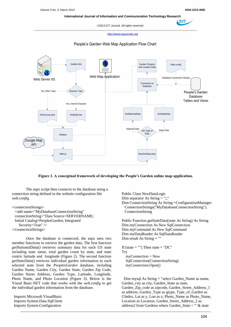
map application. Figure 1 illustrates a conceptual framework
for the integration of the major components. The
implementation is done using the Microsoft Visual Studio
Express, which is a light-weight version of the Microsoft’s
Visual Studio (VS) and provides a set of free software
programs in the form of Microsoft’s integrated development
environment (IDE). The VS Express includes Visual Web
Developer Express (VWDE), Visual Basic Express, Visual
C++ Express, Visual C# Express and SQL Server Express. The
VWDE allows application developers to create ASP websites
with the programming language either Visual C# or Visual
Basic. It has a very user friendly interface for web design. The
SQL Server Management Studio Express provides the
capability to edit, update, and manage SQL Server Express
database. For instance, the developer can create a new SQL
database for a web site but import the data from Oracle,
Microsoft ACCESS, Excel or ODBC sources. For this project,
Visual Web Developer 2010 Express was chosen to develop the
USDA online map application, and SQL Server Management
Studio 2008 Express was selected to import the USDA garden
database and to create a new SQL database called
PeoplesGarden for the application development environment.
In PeoplesGarden database, two views (virtual tables) were
created to dynamically summarize the total garden counts based
on the state names. Using the standard Structured Query
Language (SQL), the first view called Gardens was created to
tally the number of gardens for each US state, and the second
view called State_Centerpoints that contains the center latitude
and longitude of each state was appended to the first view so
that the summary data can be displayed in the map window.
Microsoft aspx.NET technology was employed to connect to
and retrieve data from the database. An aspx page contains
scripts written in Microsoft .NET languages such as Visual
Basic.NET and C#.NET. In this application, Visual Basic.NET
was used to perform all the database tasks.
As shown in Figure 1, when the garden.htm is accessed by a
web user, it first determines the user’s web browser type (see
section 2.4) and a browser-specific html file calls an initialize
function from the Main.js JavaScript file. When the Main.js
initializes the online map page, it sends a request to an aspx
named NewGetData.aspx (see below). The aspx script retrieves
garden data either at the national level or at the state level from
PeoplesGarden database depending on users’ requests.
function initialize()
{
geocoder = new google.maps.Geocoder();
//For centering map on contiguous USA
var myLatlng = new google.maps.LatLng(38, -95);
var myOptions = {
zoom: 4,
center: myLatlng,
scaleControl: true,
mapTypeId:
google.maps.MapTypeId.ROADMAP }
map = new google.maps.Map(document.getElementById
("map_canvas"), myOptions);
//Calls an aspx script to retrieve data from SQL Server database
$.get("newGetData.aspx?level=national", displaynational);
}
Volume 3 No. 3, March 2013 ISSN 2223-4985
International Journal of Information and Communication Technology Research
©2013 ICT Journal. All rights reserved
http://www.esjournals.org
104
Web Server IIS
Garden.htm
Browser Type
PGMSIE.htmPGChrome.html
Yes, Internet Explorer
No, Other Type
Initialize
Main.js NewGetData.aspx
Get Type of
Data
GetNationalData GetStateData
Connection to
Database
Web.config
State DataNational Data
Garden Property
and Location Data
People’s Garden
Database
Tables and Views
Database Connection Strings
People’s Garden Web Map Application Flow Chart
Google Map
API
Web Map Application
Figure 1. A conceptual framework of developing the People’s Garden online map application.
The aspx script then connects to the database using a
connection string defined in the website configuration file
web.config.
<connectionStrings>
<add name="MyDatabaseConnectionString"
connectionString="Data Source=SERVERNAME;
Initial Catalog=PeoplesGarden; Integrated
Security=True" />
</connectionStrings>
Once the database is connected, the aspx uses two
member functions to retrieve the garden data. The first function
getNationalData() retrieves summary data for each US state
including state name, total garden count by state, and state
centric latitude and longitude (Figure 2). The second function
getStateData() retrieves individual garden information in each
selected state from the PeoplesGarden database, including
Garden Name, Garden City, Garden State, Garden Zip Code,
Garden Street Address, Garden Type, Latitude, Longitude,
Photo Name, and Photo Location (Figure 3). Below is the
Visual Basic.NET code that works with the web.config to get
the individual garden information from the database.
Imports Microsoft.VisualBasic
Imports System.Data.SqlClient
Imports System.Configuration
Public Class NewDataLogic
Dim separator As String = ";;"
Dim ConnectionString As String =ConfigurationManager.
ConnectionStrings("MyDatabaseConnectionString").
ConnectionString
Public Function getStateData(state As String) As String
Dim myConnection As New SqlConnection
Dim myCommand As New SqlCommand
Dim myDataReader As SqlDataReader
Dim result As String = ""
If (state = "") Then state = "DC"
Try
myConnection = New
SqlConnection(ConnectionString)
myConnection.Open()
Dim mysql As String = "select Garden_Name as name,
Garden_city as city, Garden_State as state,
Garden_Zip_code as zipcode, Garden_Street_Address_1
as address, Garden_Type as gtype, Type_of_Garden as
CIndex, Lat as y, Lon as x, Photo_Name as Photo_Name,
Location as Location, Garden_Street_Address_2 as
address2 from Gardens where Garden_State = '" & state

Volume 3 No. 3, March 2013 ISSN 2223-4985
International Journal of Information and Communication Technology Research
©2013 ICT Journal. All rights reserved
http://www.esjournals.org
105
& "'"
myCommand = New SqlCommand(mysql,
myConnection)
myDataReader = myCommand.ExecuteReader()
Dim x As String
Dim y As String
Dim name As String
Dim st As String
Dim city As String
Dim zip As String
Dim addr As String
Dim cindex As String
Dim gtype As String
Dim Photo_Name As String
Dim Location As String
Dim address2 As String
While myDataReader.Read()
If (IsDBNull(myDataReader("x"))) Then
x = ""
Else
x = CStr(myDataReader("x"))
End If
If (IsDBNull(myDataReader("y"))) Then
y = ""
Else
y = CStr(myDataReader("y"))
End If
If (IsDBNull(myDataReader("name"))) Then
name = ""
Else
name = CStr(myDataReader("name"))
End If
If (IsDBNull(myDataReader("State"))) Then
st = ""
Else
st = CStr(myDataReader("State"))
End If
If (IsDBNull(myDataReader("city"))) Then
city = ""
Else
city = CStr(myDataReader("city"))
End If
If (IsDBNull(myDataReader("zipcode"))) Then
zip = ""
Else
zip = CStr(myDataReader("zipcode"))
End If
If (IsDBNull(myDataReader("address"))) Then
addr = ""
Else
addr = CStr(myDataReader("address"))
End If
If (IsDBNull(myDataReader("CIndex"))) Then
cindex = ""
Else
cindex = CStr(myDataReader("CIndex"))
End If
If (IsDBNull(myDataReader("gtype"))) Then
gtype = ""
Else
gtype = CStr(myDataReader("gtype"))
End If
If (IsDBNull(myDataReader("Photo_Name")))
Then
Photo_Name = ""
Else
Photo_Name =
CStr(myDataReader("Photo_Name"))
End If
If (IsDBNull(myDataReader("Location"))) Then
Location = ""
Else
Location = CStr(myDataReader("Location"))
End If
If (IsDBNull(myDataReader("address2"))) Then
address2 = ""
Else
address2 = CStr(myDataReader("address2"))
End If
If (x <> "") And (y <> "") Then
result = result + y + separator + x
result = result + separator + name + separator + st
result = result + separator + city + separator + zip
result = result + separator + addr + separator +
cindex
result = result + separator + gtype + separator +
Photo_Name
result = result + separator + Location + separator +
address2
result = result + "|"
End If
End While
myDataReader.Close()
myDataReader = Nothing
Catch ex As Exception
Finally
myConnection.Close()
myConnection = Nothing
End Try
Return result
End Function
The result string generated from the above code that
contains individual garden information is passed back to
Main.js and then processed to a point on the online map.
2.3. Development of Searching and Filtering
Functions
Volume 3 No. 3, March 2013 ISSN 2223-4985
International Journal of Information and Communication Technology Research
©2013 ICT Journal. All rights reserved
http://www.esjournals.org
106
It is required for this project to provide the user with a web
interface for search functions such as Find Gardens by Location
(e.g., address or zip code) and Find Gardens by State (Figure 2)
so the user can have the option to see only selected gardens
around that address or zipcode, or within that state.
Furthermore, search functions need to be accompanied by
another function called Filter by Type. The first two functions,
Find Gardens by Location and Find Gardens by State, were
accomplished by using Google Maps API’s Geocoding process,
which converts addresses (e.g., "8008 Davis Dr., St. Louis,
MO") into geographic coordinates (e.g., latitude 38.64005705
and longitude -90.3373296). With this pair of latitude and
longitude, the programmer can place a marker onto the map.
This can be done using the geocoder function (i.e., class) from
the Google Maps API. However, the programmer has to create
a new geocoder object within the Main.js function initialize() as
follows:
var geocoder = new google.maps.Geocoder();
and then create a new codeaddress () function (refer to
https://developers.google.com/maps/documentation/javascript/g
eocoding).
2.4. Web Browsers Compatibility
It is anticipated that the USDA online map service needs to be
used in most of the web browsers such as Microsoft Internet
Explorer (IE) 7.0+, Google Chrome, Mozilla Firefox, and
Apple Safari. The initial testing of the USDA online map
application indicated that there were compatibility issues. For
instance, Microsoft IE (7, 8 and 9) and Mozilla Firefox did not
support rounded corners for tabbed panels. Apple Safari for
iPad and iPhone did not support flash movies. Only Google
Chrome did not have any problem. Those issues were resolved
by offering a main page Garden.htm to detect whether the
browser is IE or Google Chrome, Mozilla Firefox, and Apple
Safari. If it is IE, the web page is automatically redirected to
PGMSIE.htm; otherwise, it is redirected to PGchrome.html.
Below is the code for Garden.htm.
<html>
<head>
<meta name="viewport" content="initial-scale=1.0, user-
scalable=no" />
<meta http-equiv="content-type" content="text/html;
charset=UTF-8" />
<title>USDA People's Garden Initiative</title>
<script type="text/javascript" language="JavaScript">
function detectbrowser() {
var browserName = navigator.appName;
switch (browserName) {
case ("Microsoft Internet Explorer"):
document.write('<META HTTP-EQUIV="REFRESH"
CONTENT="1;URL=PGMSIE.htm">'); break;
case ("Chrome"):
case ("Firefox"):
case ("Safari"):
case ("Mozilla"):
case ("Netscape"):
document.write('<META HTTP-EQUIV="REFRESH"
CONTENT="1;URL=PGchrome.html">');
break;
default: alert("You browser might not be supported");
}
}
</script>
</head>
<body>
<p> People's Garden</p>
<script type="text/javascript" language="JavaScript">
detectbrowser();
</script>
</body>
</html>
2.5. Use of JavaScript and CSS to Design the Layout
of the Online Map Application
In the design of the online map application, a HTML table with
three-row layout design was adopted, including first row for a
tabbed interface, second row for the map container, and third
row for the garden type legend. In the tabbed interface, two
tabs are provided, including one for Find Gardens by Location,
and the other for Find Gardens by State (Figure 2). The tabbed
interface was developed using the Adobe’s Spry 1.6 framework
for Ajax, which is a JavaScript library for the development of
interactive web pages ([17]. To do so, the programmer has to
download SpryTabbedPanels.css and SpryTabbedPanels.js (all
open sources) from the Adobe Labs. The former links the CSS
for the tabbed panel; the latter links the Spry TabbedPanels
JavaScript library with the search functions. Both of them need
to be placed in the head section of the web page (i.e.,
PGMSIE.htm or PGChrome.html) as follows:
<link href="SpryTabbedPanels.css" rel="stylesheet"
type="text/css" />
<script src="SpryTabbedPanels.js" type="text/javascript">
</script>
Working in conjunction with the tab Find Gardens by Location
is the HTML <input> tag and input field that allow the user to
type in address or zip code from the keyboard. The HTML code
looks as below:
<input id="address" size="40" type="textbox"
value="Please type your address or zipcode here">
Then, the <select> tag is used to create a drop-down list for the
user to select an item from a list and the <option> tags inside
the select element specify the available items (i.e., options) in
the list. For instance, Filter by Type allows the user to choose
one of the five garden types with 0 as a default value for no
filtering. It was implemented with the following HTML code:
<select id = "select_type" name="Garden_Type">
<option value="0" selected>Filter by Type</option>
<option value="1">At USDA Facilities</option>
Volume 3 No. 3, March 2013 ISSN 2223-4985
International Journal of Information and Communication Technology Research
©2013 ICT Journal. All rights reserved
http://www.esjournals.org
107
<option value="2">At Schools</option>
<option value="3">At Other Places within the Community
</option>
<option value="4">At Faith-based Centers</option>
<option value="5">At Other Federal Agencies</option>
</select>
Similarly, the tab Find Gardens by State allows the user to
choose one state from the list with “All States” as the default
value to show all the gardens in the entire United States and its
territories. It is worthy of note that each tab is linked to the
search function and filter function described in the Section 2.3.
In the map container, the Google map or satellite imagery is
displayed, and points of interest (e.g., gardens) are marked with
the customized marker icons – the green shovel for gardens at
USDA facilities, the yellow shovel for gardens at schools, and
so on. The garden type legend is placed at the bottom of the
map contains that match the marker icons displayed in the map
container.
In order to provide the user with interaction with the map, a
few standard Google Maps controls are added, such as Pan and
Zoom controls; Map Scale control; and Map Type control–
Roadmap and Satellite. In addition, tooltips (e.g., garden name)
to the markers are provided, along with clickable marker icons
with Google Maps API’s standard Infowindow, which displays
the information about each garden (i.e., garden name, address,
city, state, zip code, a link to garden pictures, etc.).
3. RESULTS
The use of Google Maps API V3 provides a very efficient
mechanism to deliver digital cartographic information to the
Internet users with fast response time and user friendly
interaction. Using Google Maps standard Map Type control,
the user is able to choose one of the two map types: roadmap or
satellite imagery. Figure 2 shows the startup view of the
People’s Garden online mapping application in Google Chrome.
At the initial launch of the web page is the display of Google
Maps with the number of gardens in each state. This gives the
user a clear idea where most of the gardens are concentrated.
Notice that in Figure 2 there are two tabs, Find Gardens by
Location and Find Gardens by State. The user can click one of
them to perform the search functions.
Figure 3 shows the result of a search function, Find Gardens by
State. In this case, the user selects the state of Illinois. All of the
individual gardens in the state are displayed on the map with
the customized marker icons. The map legend at the bottom of
the screen provides the five types of gardens shown on the map.
This feature provides the user with a clear understanding about
the gardens he/she is looking at.
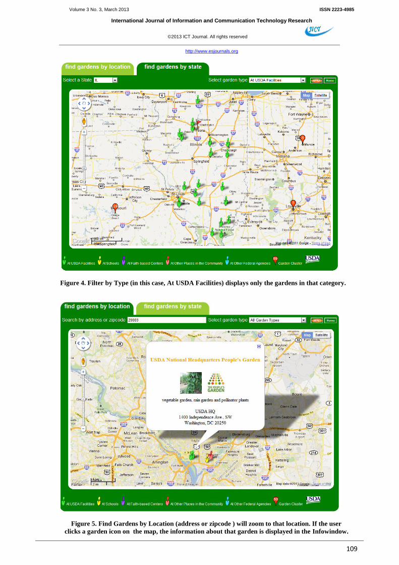
Figure 4 shows the result a Filter by Type function. In this case,
the user first select all the gardens in the state of Illinois and
then filer the gardens by a type (e.g., At USDA Faculties).
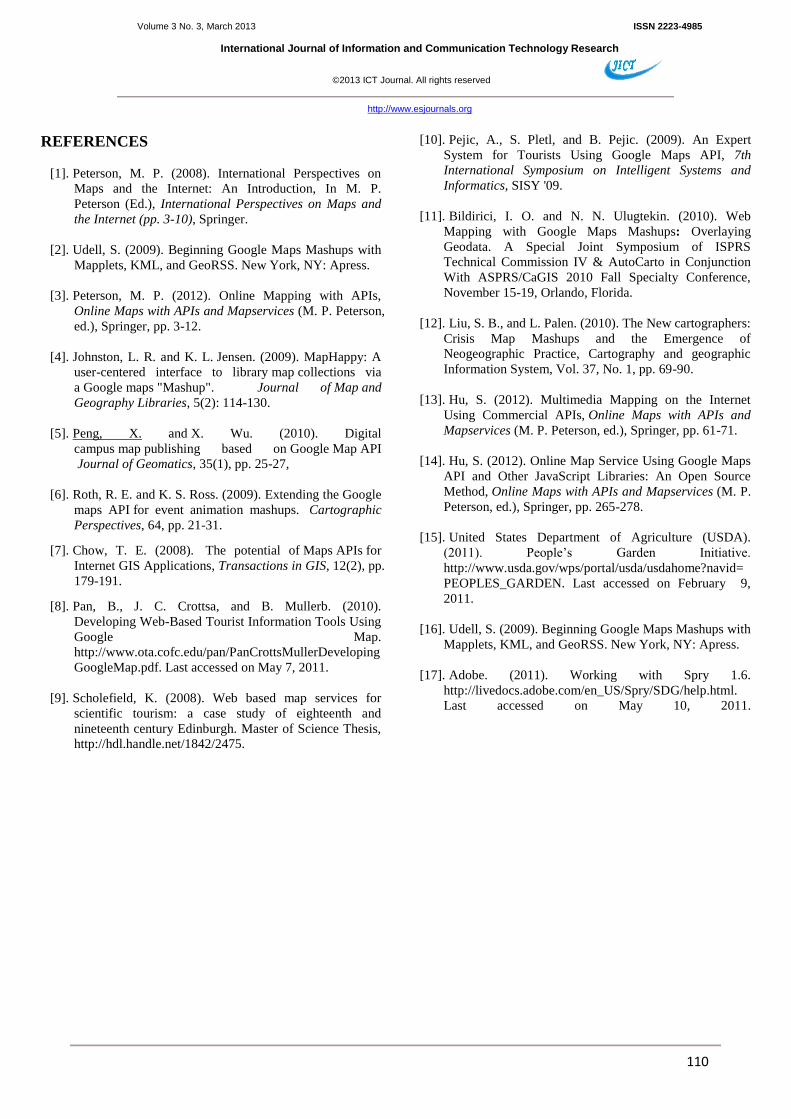
Figure 5 shows the result of another search function, Find
Gardens by Location, using addresses or zip codes. The user
can first type in the street
address, city, and state, or a zip code, and the map window will
zoom into that address or zip code and display all the gardens
around it. The user can then filer the gardens by a type (e.g., At
USDA Facilities). The user can click on an icon at any time to
get specific information about that garden in the standard
Google Infowindow.
4. CONCLUSION AND DISCUSSION
This paper has demonstrated an online mapping application that
was successfully developed using Google Maps API v3,
Google Geocoding, Microsoft SQL Server Express database,
and Spry Framework for Ajax. The case study presented in this
article provides the advanced functionality to display the
locations and state-based summary counts of USDA’s
thousands of peoples’ gardens on the Internet with customized
icons and map legend. It also provides the sophisticated
functionalities for searching, filtering, and tabbed interface that
offer the user the capability to manipulate the data.
Online mapping from a database being updated in real time can
be very useful for many purposes. First, the database can be
collected from an online registration process that, along with
other information contains locational information such as
latitude and longitude or street addresses. This is the way how
the USDA people’s garden information has been gathered.
Such database can be stored on a secure server inside a firewall.
Second, once the data has been collected and stored, it can be
easily and directly retrieved in full or partially for online
mapping application without going through a data format
transformation as it has been done in the past (e.g., XML).
Third, the backend database can be updated through the
database interface and the resulting data changes will be
reflected immediately on the web interface. Fourth, complex
data manipulation can be carried out using the powerful SQL
scripts in the backend databases.
Publishing and sharing geo-spatial data are becoming important
and popular tasks in various applications. One particular sector
is in the public health. Doctors at different offices across a
region or a country can report certain type of disease (e.g.,
West Nile Virus, SARS) in real time to a centralize database,
and such information can be delivered to an online map
immediately so the health officials and the general public can
quickly take preventive actions. The project described in this
paper can be easily modified to meet the requirements of such
important tasks.
ACKNOWLEDGEMENTS
We thank USDA People’s Garden Initiative director Livia
Marques for her leadership in this project, USDA Annie
Ceccarini for her initial web interface design, USDA NRCS
Tianpu Liang for his ASP.NET coding and database connection
support, USDA OCIO John Roccaforte for providing database
access, and Acacia Dai of the Thomas Jefferson High School
for Science and Technology for graphics design for the web
page.
Volume 3 No. 3, March 2013 ISSN 2223-4985
International Journal of Information and Communication Technology Research
©2013 ICT Journal. All rights reserved
http://www.esjournals.org
108
Figure 2. The initial view of the USDA People’s Garden online map application
with the number of gardens for each state.
Figure 3. Find Gardens by State displays only the gardens in a selected state.
The map legend at the bottom indicates the type of the gardens.
Volume 3 No. 3, March 2013 ISSN 2223-4985
International Journal of Information and Communication Technology Research
©2013 ICT Journal. All rights reserved
http://www.esjournals.org
109
Figure 4. Filter by Type (in this case, At USDA Facilities) displays only the gardens in that category.
Figure 5. Find Gardens by Location (address or zipcode ) will zoom to that location. If the user
clicks a garden icon on the map, the information about that garden is displayed in the Infowindow.
Volume 3 No. 3, March 2013 ISSN 2223-4985
International Journal of Information and Communication Technology Research
©2013 ICT Journal. All rights reserved
http://www.esjournals.org
110
REFERENCES
[1]. Peterson, M. P. (2008). International Perspectives on
Maps and the Internet: An Introduction, In M. P.
Peterson (Ed.), International Perspectives on Maps and
the Internet (pp. 3-10), Springer.
[2]. Udell, S. (2009). Beginning Google Maps Mashups with
Mapplets, KML, and GeoRSS. New York, NY: Apress.
[3]. Peterson, M. P. (2012). Online Mapping with APIs,
Online Maps with APIs and Mapservices (M. P. Peterson,
ed.), Springer, pp. 3-12.
[4]. Johnston, L. R. and K. L. Jensen. (2009). MapHappy: A
user-centered interface to library map collections via
a Google maps "Mashup". Journal of Map and
Geography Libraries, 5(2): 114-130.
[5]. Peng, X. and X. Wu. (2010). Digital
campus map publishing based on Google Map API
Journal of Geomatics, 35(1), pp. 25-27,
[6]. Roth, R. E. and K. S. Ross. (2009). Extending the Google
maps API for event animation mashups. Cartographic
Perspectives, 64, pp. 21-31.
[7]. Chow, T. E. (2008). The potential of Maps APIs for
Internet GIS Applications, Transactions in GIS, 12(2), pp.
179-191.
[8]. Pan, B., J. C. Crottsa, and B. Mullerb. (2010).
Developing Web-Based Tourist Information Tools Using
Google Map.
http://www.ota.cofc.edu/pan/PanCrottsMullerDeveloping
GoogleMap.pdf. Last accessed on May 7, 2011.
[9]. Scholefield, K. (2008). Web based map services for
scientific tourism: a case study of eighteenth and
nineteenth century Edinburgh. Master of Science Thesis,
http://hdl.handle.net/1842/2475.
[10]. Pejic, A., S. Pletl, and B. Pejic. (2009). An Expert
System for Tourists Using Google Maps API, 7th
International Symposium on Intelligent Systems and
Informatics, SISY '09.
[11]. Bildirici, I. O. and N. N. Ulugtekin. (2010). Web
Mapping with Google Maps Mashups: Overlaying
Geodata. A Special Joint Symposium of ISPRS
Technical Commission IV & AutoCarto in Conjunction
With ASPRS/CaGIS 2010 Fall Specialty Conference,
November 15-19, Orlando, Florida.
[12]. Liu, S. B., and L. Palen. (2010). The New cartographers:
Crisis Map Mashups and the Emergence of
Neogeographic Practice, Cartography and geographic
Information System, Vol. 37, No. 1, pp. 69-90.
[13]. Hu, S. (2012). Multimedia Mapping on the Internet
Using Commercial APIs, Online Maps with APIs and
Mapservices (M. P. Peterson, ed.), Springer, pp. 61-71.
[14]. Hu, S. (2012). Online Map Service Using Google Maps
API and Other JavaScript Libraries: An Open Source
Method, Online Maps with APIs and Mapservices (M. P.
Peterson, ed.), Springer, pp. 265-278.
[15]. United States Department of Agriculture (USDA).
(2011). People’s Garden Initiative.
http://www.usda.gov/wps/portal/usda/usdahome?navid=
PEOPLES_GARDEN. Last accessed on February 9,
2011.
[16]. Udell, S. (2009). Beginning Google Maps Mashups with
Mapplets, KML, and GeoRSS. New York, NY: Apress.
[17]. Adobe. (2011). Working with Spry 1.6.
http://livedocs.adobe.com/en_US/Spry/SDG/help.html.
Last accessed on May 10, 2011.
Recommended