OSC FINAL_Minutes16-1110.docx 1
Los Altos Hills Open Space Committee Los Altos Hills Parks and Recreation Building
FINAL Minutes of Regular Meeting November 10, 2016
Members and Associates Present: George Clifford, Nancy Couperus, Kit Gordon, Sharen Schoendorf, Jean Struthers, Wendie Ward, Sue Welch (Members); Richard Contreras, Karen Lemes (Associates)
Members and Associates Absent: Alice Sakamoto (Member) Council Liaison Present: Gary Waldeck Member of Public Present: Peter Brown (LAH resident) Kjell Karlsson (LAH Finance and Investment Committee) Tina Tseng (LAH Engineer) Rosy Ko (Top Elegant Investment, LLC subdivision) Jeff Peterson (Top Elegant Investment, LLC subdivision) Steve Rabkin (24990 La Loma Drive) Steve Borlink (24990 La Loma Drive) 1. Call to Order and Approval of Minutes
A. Roll Call. NC called the meeting to order at 9:00 am. B. Acceptance of Meeting Minutes. KG moved to accept with minor amendments the minutes of the
October 13, 2016 meeting. GC seconded and vote was unanimously in favor (GC, NC, KG, SS, JS, WW, SW).
2. New Business 3. Continuing Business
A. Presentation from Developers of Stirling (Top Elegant Investment, LLC) Subdivision. SW and SS recused themselves for proximity. At a Planning Commission Study Session on Sep 1, 2016 the developers presented an update of their project plans. At the Oct OSC meeting, the committee prepared a draft response to the developers’ updated project plans (Attachment A). In September, the developers requested to give a presentation at the Nov 2016 OSC meeting. At today’s meeting Jeff Peterson, Project Engineer asked to respond to OSC comments and to return to OSC in December to give an additional 1.5 hour presentation. He said the developers are revising the drainage (storm water) plans. Discussion included the concept of “gridding”; connections to open space easements (OSEs) on adjacent parcels; language for OSEs; the proposed “oak preservation easement”; the OSE along the eastern and northern borders; fencing issues; LAH building and fence setbacks. OSC requested developers send a copy of their presentation materials for the December OSC meeting to allow members time to review it. After further discussion, GC moved that OSC resubmit the October recommendation to the City Clerk as written with no changes. WW seconded and the vote was 5 in favor (GC, NC, KG, JS, WW) and 2 abstaining for proximity (SS, SW).
B. Re-review of 24990 La Loma Drive (Lands of Rabkin and Vandergriff). OSC reviewed this project on 8/12/16 with a recommendation that included removal of barbwire fencing; dedication of an OSE along the southern portion of the property and a riparian easement 40 feet from the southern property line to protect Hale Creek (Attachment B). The developers requested to reduce the OSE to create a play area. After lengthy discussion, WW moved that OSC reviewed the development plans for the parcel at the last meeting and considers that the OSE proposed then meets criteria for OSE as defined in Town policies and ordinances; and that the OSC recommendation from the August meeting remain unchanged. The vote was unanimously in favor (GC, NC, KG, JS, SS, WW, SW).
C. Byrne Preserve: i) Grassroots Ecology (GRE) Workdays. GRE has resumed invasive plant removal work at Byrne and
will hold workdays every other Monday through December 19. Monday Nov 25 will be a creek bioengineering workday to install willow branches to stop erosion.
ii) Request for Section of Fence. Grassroots Ecology (GRE) has requested approval and funds from OSC budget to install a 250-ft section of fence to protect a short reach of Moody Creek and the adjacent floodplain from horse activity (Attachment C). GRE is restoring this area as part of the 3-year grant from SCVWD supplemented with Town funds. After volunteers removed the tall, overgrown invasive plants from this area, it became more accessible to horses, which are now

OSC FINAL_Minutes16-1110.docx 2
trampling the creek banks and dropping manure in the creek bed. The eroding banks and fresh manure are a serious water quality issue. Best Management Practices recommend fencing off creeks from livestock. OSC discussed options for fencing, which must be safe for horses and permeable to wildlife. Post and wire fencing (like Byrne perimeter fence) or split rail was suggested. GRE and barn manager, Torie Dye should be involved in planning. GRE reported that up to $1K is available from the SCVWD grant; additional funding could come from OSC budget. SW moved that OSC send a memo to City Manager, Carl Cahill, supporting Grassroots Ecology request for a wildlife permeable fence to protect the section of Moody Creek and the adjacent floodplain that is under restoration. OSC will consult with barn manager Torie Dye for recommendation for fence that will be safe for horses, but keep them out of the creek and restoration area. KG seconded and the vote was in 6 favor (GC, NC, KG, JS, WW, SW) and one opposed (SS).
iii) Night Walk. Last month Grassroots Ecology sponsored a night walk in Byrne Preserve. Eleven attended and enjoyed seeing many nocturnal insects and other “nightlife” that inhabit the preserve.
D. Creek Signage. KG suggested inviting Allen Chen, the new LAH Director of Public Works, to an OSC meeting introduce the OSC and review ongoing projects.
E. Town Newsletter Articles. Articles from OSC are planned for future issues on Palo Alto Animal Services (AS), Dr. Albert Barnitz Byrne, and identification and management of pest plants.
F. Wildlife Seminar on Snakes. JS will follow up on arrangements. G. Coyote Sightings. Nothing reported. H. Property Review Information Sheet. It was suggested OSC ask each City department to post on the
Town web site a list of projects they are working on (as Public Works already does). KG spoke to Planning Director Suzanne Avila, who said this information is already available in the Manager’s Report and will keep OSC informed of ongoing projects.
I. Subdivision Ordinance Update. KG reported this ordinance needs to be updated to meet new state code. OSC will follow the process, which includes public hearings.
J. Follow-up on OSC Open Space Easement Recommendations. KG spoke with Planning Director about this, who said planning staff records this info and will provide these. KG added a section at the end of the property review information sheet. Approved OSEs eventually appear as Council Resolutions that are approved at Council meetings. Prior to that, OSEs are shown (or not) as conditions of development for properties at Fast Track or Planning Commission meetings. Members must check agendas for these meetings to follow the outcomes.
6. Planning A. Fence Permit Reviews. One set of plans was received and reviewed by AS. B. Site Plan Reviews.
i) 25383 La Rena Drive (Lands of Heng; APN 175-38-007; #258-16-ZP-SD-GD). The reason for OSC review is construction of a new residence. KG and JS made a site visit and drafted a recommendation (Attachment D). A tributary of Purissima Creek flows along the back (western) border of the parcel; it has defined banks and is identified on the Eco-Atlas map. There are a number of heritage oaks and other trees on this part of the parcel and an old fence in the creek bed. The slope drops off steeply along the south border. Adjacent parcel to south has a large OSE. After further discussion, GC moved the OSC accept the draft recommendation to request dedication of a 25-foot open space easement from top of creek bank with easement continue to the oak/pine grove then along contour line 384 to eastern edge of property. Remove structures from easement including fence in creek bed. NC seconded and the vote was unanimously in favor (GC, NC, KG, JS, SS, WW, SW).
ii) 12815 Deer Creek Lane (Lands of Chan; APN 175-43-047). The reason for OSC review is a 2-lot subdivision. GC, NC, KG, and WW made a site visit. Deer Creek flows through the subdivision and an OSE exists on one of the parcels. There are questions about the location of the top of bank of the creek on the lower lot and a possible OSE on the upper lot. Recommendation was deferred to allow other members to visit the site.
iii) 14172 Amherst Court (Lands of Lakhani; APN 182-41-006; #373-16-ZP-SD-GD). The parcel has frontage on Amherst and Page Mill Road. Matadero Creek runs along the Page Mill frontage; a drainage easement exists in this area. The lot has dense oak coverage on the slope facing Page Mill. JS and SW volunteered to make a site visit and draft a recommendation.

OSC FINAL_Minutes16-1110.docx 3
iv) 13875 Mir Mirou Drive (APN182-32-029). This and adjacent lots all have large OSEs. Recommendation was deferred to allow a site visit.
5. Communications from the Floor. A. Peninsula-South Bay Watershed Forum. Dec 6 at PCC 1-3 pm. Topic: Planning and Implementation
of Stormwater Green Infrastructure in Local Watersheds. Learn about Bay Area’s storm water regulatory background, the pollutants of concern, benefits of Green Infrastructure, examples of local completed Green Infrastructure projects and design/maintenance issues. Santa Clara Valley Urban Runoff Pollution Prevention Program (SCVURPPP) and Santa Clara Valley Water District have a Prop 1 grant for approximately $1M for local projects.
B. Lehigh Quarry Update. Meeting will be held Nov 16, 2016 in Cupertino. 6. Open Discussion. 7. Adjournment. The meeting was adjourned at 11:21 am. Next Regular Meeting: Thursday, December 10, 2016 9:00 AM at LAH Parks and Recreation Building Attachment A: OSC Response to Stirling Subdivision Presentation at Sept 1, 2016 Planning Commission Attachment B: OSC Recommendation for 24990 La Loma Drive (8/12/16) Attachment C: Grassroots Ecology Proposal for Fencing Attachment D: DRAFT OSC Recommendation for 25383 La Rena Drive Final minutes were adopted as amended at the regular Open Space Committee meeting of Dec 8, 2016.

1
To: SuzanneAvilaDate: October18,2016From: OpenSpaceCommitteeSubject: Comments&RecommendationsonStirlingSubdivisionProposal
Introduction
OnSeptember24,2012andJanuary14,2014,theOpenSpaceCommitteewroteasetofrecommendationsfortheproposedsubdivisionat28030NatomaRoad,knownastheStirlingSubdivision.SinceJanuary2014,moreinformationhasbeenmadeavailable.OutlinedbelowarecurrentrecommendationsfromtheOpenSpaceCommitteebasedoninformationpostedontheTown'swebsite.
PropertyCharacteristics
The18.18acrepropertyhasawealthofenvironmentalassetsandgeologicalcomplexities:
• moderatelysteeptoprecipitousslopes• MataderoCreektributaryandheadwaters• ripariancorridor• largenaturaldrainageswaleofunstablecolluvialsoil,proposedfordevelopment• ephemeralcreekemanatingfrombowlofswale• severalsmalllandslidesandtwolargelandslides• naturalspringsemanatingfromthelargestofthelandslides• MonteVistaFault• productive,activewell• extensivematureoakwoodlandinareasproposedfordevelopment• grasslandmeadowandchaparralbrush• significantportionofsitedesignatedasOpenSpaceConservationArea• abundanceoffloraandfaunaspeciesonandaroundthissite• thepropertyservesasacriticalhubforwildlifemovement,linkingmajoropen
spaceareasinthispartofTown:• ArastraderoPreserve• MataderoCreek• PoorClare’sMonasteryandlandstotheeast• ByrnePreserve
9-1.501Tothedegreethatthenaturalamenities,characteristics,topography,vegetationandwildlife,arepreserved,theprobabilityofacceptanceofagivensubdivisionwillbeenhanced.9-1.102(d)Topreserveandprotectthenaturalbeautyandtheestablishedcharacterofthecommunityand,throughgooddesign,toprovideforaharmoniousrelationshipbetweencompletedsubdivisionsandthenaturalenvironment.
MunicipalCode,Title9Subdivisions

2
OpenSpaceCommitteeRecommendationSummary
ThekeyrecommendationsandconcernsfromtheOpenSpaceCommitteearelistedhere.Thefollowingpagesprovideadditionaldetailsforeachlistedtopic.
1. EnvironmentalImpactReport(EIR)Recommended
2. OakWoodlandOpenSpaceEasement
3. EasternBoundaryOpenSpaceEasement
4. FenceSetbackBetweenSidesofNewlyProposedLots
5. ConnectiontoNeighboringOpenSpaceandPathwayEasements
6. DrainageSwaleOpenSpaceEasement(majorityofproposedlot7)
7. De-centralizedStormwaterManagement
8. ManmadeSelf-retainingDrainageSwaleEasement
9. SteepSlopesandCreekOpenSpaceEasement
10. LandslidesandSpringOpenSpaceEasement;EliminateSubdrainSystem
11. NorthernBoundaryOpenSpaceEasement(overpathwayeasement)
12. StaggerLotLinesRelativetoExistingResidences
13. ReduceSwitchbacksandLengthonPathway;ObtainAgencyAdviceonBridge
14. CorrectErrorsonSlopeandLUFWorksheets

3
Figure1:MapofOpenSpaceEasementRecommendations

4
Figure2:TownofLosAltosHillsLandUseDiagramSignificantportionofpropertyisinOpenSpaceConservationArea
OpenSpaceConservationAreaWithin these areas, special measures should be taken to conserve the natural quality of the area and to avoid environmental degradation. Residences should be placed on the most buildable portions of lands designated OSCA and carefully sited so as to preserve existing trees, vegetation and wildlife habitat.
LAHTownGeneralPlan,LandUseElement

5
OSCRecommendations
1.EnvironmentalImpactReport(EIR)
Weconcludethatthereispotentialforsignificantenvironmentaldegradationsfromtheproposeddevelopmentwithinsufficientmitigationsandthereforealternativesshouldbeassessed.SignificantdetailsandelementsaremissingfromtheInitialStudy/MitigatedNegativeDeclaration(IS/MND)andweurgetheTownnottosigntheIS/MND.Cumulativeimpactshavenotbeenanalyzed.AnEIRwouldbeinthebestinterestoftheapplicantandtheTown.AgencyreviewfromRegionalWaterControlBoard(RWQCB)andCaliforniaDepartmentofFishandWildlife(CDFW)withcollaborationwithCaliforniaNativePlantSociety(CNPS)isessentialtoprotectMataderoCreekandtherichhabitatfromdetrimentalimpactsnotonlyonthepropertybutextendingtotheMataderowatershed.ThelawfirmShute,Mihaly&Weinberger,representingFriendsofUpperMataderoCreek,givesampleexamplesofshortcomingsandinconsistenciesintheIS/MNDintheirlettertotheTown.
BecauseofthelegalshortcomingsoftheInitialStudy,andtheimpracticabilityofmitigatingimpactsthatwillclearlyresultfromtheProject,theTownofLosAltosHills("Town")mustrejecttheInitialStudyandrequireanenvironmentalimpactreport("EIR")initsplacetofullyanalyzetheProject'simpactsandproposeafullrangeofalternatives....Town'sfailuretorequireanadequatereviewwillleavetheTownvulnerabletolegalchallenge.
LettertoTownofLosAltosHillsfromShute,Mihaly&WeinbergerrepresentingFriendsofMataderoCreek,January20,2016
CEQA(CaliforniaEnvironmentalQualityAct)requirestheTown,astheLeadAgency,toidentifysignificantenvironmentalimpacts,whetherdirect,indirect,orcumulative,andtoavoidormitigatethoseimpactstoless-than-significantlevels,iffeasible.Thesignificantsizeofthisproperty,combinedwithitsenvironmentalvalue(asdiscussedatlengthbelow),meansthatcorrespondinglylargeeffortsmustbetakentoaddressthisproposedsubdivision’soverallimpacts.

6
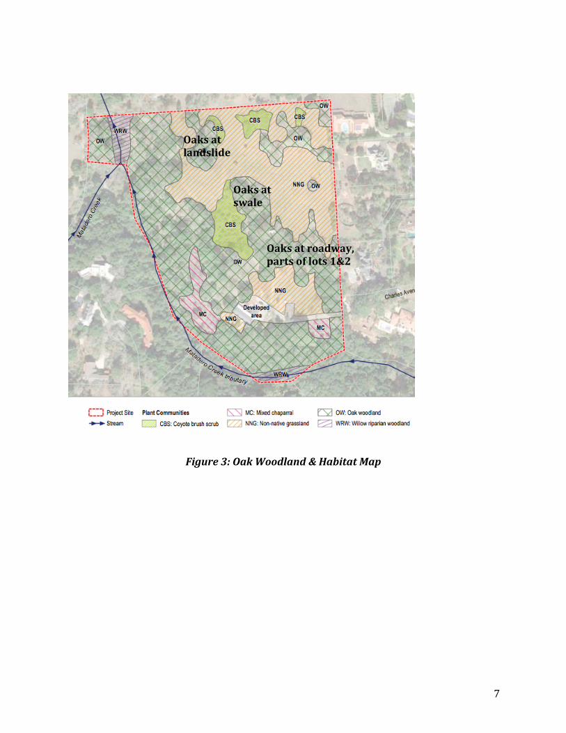
2.OakWoodlandOpenSpaceEasement
Werecommendanopenspaceeasement(OSE)forthematureoakwoodlandextendingfromtheentranceofpropertytothecenterofthepropertyincludingportionsofproposedroadway,portionsoflots1&2,bowlofswaleatproposedlot7,andlandslideinproposedlots5&6.SeeFigure1foreasementrecommendation.SeehabitatdesignationinFigure3.
• Thedeveloper'soakwoodlandeasementproposalattheSeptember1PlanningCommissionStudySessionisinsufficientinbothareaandprotection.Theireasementlanguagedoesnotappeartoprotectoaksfromremoval.WerecommendstandardOSEtoprotectoakwoodlands.
• Oakwoodlandscoverapproximately11acresofsiteprovidingplethoraofbenefitsforsoilstability,habitat,aesthetics,reducedrunoffandincreasedgroundwatertothissiteandneighboringareas.
• Oaktreesatlandslideandbowlofswalepreservehydrologicalfunctionandsoilstability.
• Roadlayoutshouldminimizeoaktreeremoval.RoadcanexistwithinOSE.
Treeshaveanumberofpotentialbenefits...:increasednutrientuptake,reducedstormwaterrunoffthroughrainfallinterceptionandevapotranspiration,enhancedsoilinfiltration,soilstabilization,increasedaestheticappeal,wildlifehabitat,andshading.Treeshavebeenshowntocapturestorm-water,reducingtherunoffvolumedirectlyandpotentiallyreducingpeakflows.Treerootscanalsodirectlyenhanceinfiltrationrates.
WRALiteratureReviewforBayAreaStormWaterManagementAgencyAssociation(BASMAA)September14,2016
Policy2.2Minimizedisturbanceofthenaturalterrainandvegetation.Preserveandprotectnativeandnaturalizedplants,withspecialattentiontopreservationofunique,rareorendangeredspeciesandplantcommunitiessuchasoakwoodlands.Policy2.3PreserveandprotectHeritageTrees,includingnativeoaksandothersignificanttrees,onpublicandprivateproperty.
LAHGeneralPlan,ConservationElement
7
Figure3:OakWoodland&HabitatMap
Oaksatlandslide
Oaksatswale
Oaksatroadway,partsoflots1&2
o

8
3.EasternBorderOpenSpaceEasement
WerecommendanOSEofatleast25feetontheeasternborderofthepropertytoprevent"suburbangridding"ofpropertieswithinthisproposedsubdivisionandwithneighboringproperties.TheSubdivisionOrdinancerequiresthatsignificantthoughttobegiventocreatingasubdivisionthatmaintainstheopenspacecharacteristicsofboththeTownandtheadjacentexistingneighborhoods.ThispropertysupportsresidentwildlifespeciesandservesasanestablishedandheavilyusedhubforwildlifemovementthroughtheTown,thereforetheimpactofhigh-densitydevelopmentonwildlifemustbeconsidered,forthesakeofthesurroundingneighborhood.ItistheTown’sresponsibilitytopreservewildlifehabitat(whichincludesitsmigratoryroutes)asmuchaspossibleinthefaceofpermitteddevelopment,anditalsoneedstoprotectsurroundingneighborhoodsfrompermanent,significantchangestotheflowofwildlife.ConsistencywithTownpoliciescaneasilybeachievedbyassuringthatalthoughthesubdivisionmayreducetheexistingroutes,itshouldnoteliminateany.
• A15footeasementwasproposedbythedeveloperattheSeptember1StudySessionisnotadequate.Atleast25feetisrecommendedduetoproximitywithneighboringpropertiesandabundanceofwildlifeaccessingthisproperty.
• Thedeveloper'sproposaltoincludepropertylinefenceswithinanopenspaceeasementisinconsistentwiththeTown'sopen,ruralcommunitygoalsandwithopenspaceeasements.
• Anyfencingintheopenspaceeasement,even“wildlife-friendly,”isdangeroustothewildlifemovingthroughit.Forexample,deerpanicandfleeonperceivingathreat,andwillcrashheadfirstintosuchfencescausinginjuryordeath.
• Theexistingwildlife-barrierperimeterfencealongeasternandnorthernbordershouldberemoved.
Policy1.7Totheextentpossible,linkopenspacestogethervisuallyandphysicallytoformasystemofopenspaces.Policy1.8Ensurethatlandusesandstructuresarecompatiblewiththegeneralopenspacequalityoftheplanningarea.Policy2.6Newresidentialsubdivisionsshallprovideopenspaceforrecreationinordertomeettheirappropriateshareoflocalrecreationneeds.
LAHGeneralPlan,OpenSpaceElementPolicy2.7Avoidthedevelopmentofenvironmentallysensitiveareasthatarerichinwildlifeorofafragileecologicalnature,suchasareasofrareorendangeredspeciesofplants,orriparianareas.Goal3:Maintainandenhancetheintegrityofwildlifehabitat.Section315:Planningfornaturalmovementofwildlifecanhelpavoid,minimizeandcompensateforseriousnegativeimpactsonwildlifeandhumans.Areasthatlinkwildlifehabitathavebecomevitalbecausenativeanimalssuchasdeer,fox,bobcat,andcoyotearepreventedbyroads,fences,homesandotherdevelopmentfrommovingfreelyastheyoncedid
LAHGeneralPlan,ConservationElement
9
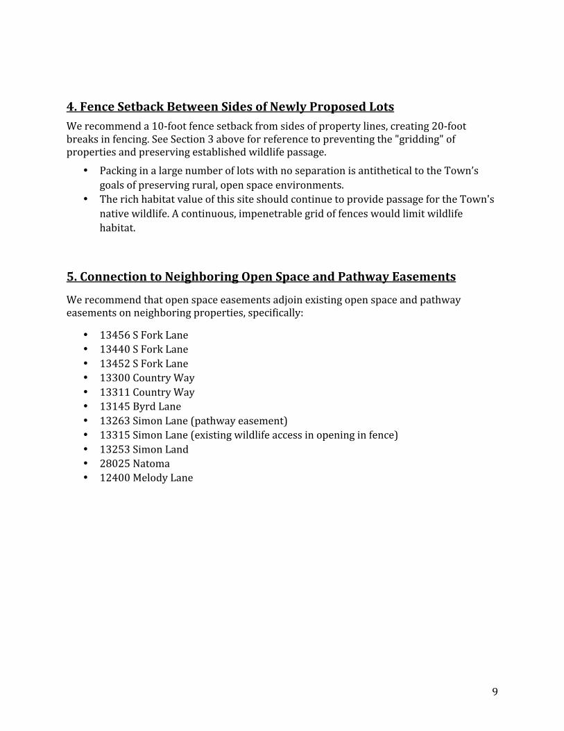
4.FenceSetbackBetweenSidesofNewlyProposedLotsWerecommenda10-footfencesetbackfromsidesofpropertylines,creating20-footbreaksinfencing.SeeSection3aboveforreferencetopreventingthe"gridding"ofpropertiesandpreservingestablishedwildlifepassage.
• PackinginalargenumberoflotswithnoseparationisantitheticaltotheTown’sgoalsofpreservingrural,openspaceenvironments.
• TherichhabitatvalueofthissiteshouldcontinuetoprovidepassagefortheTown'snativewildlife.Acontinuous,impenetrablegridoffenceswouldlimitwildlifehabitat.
5.ConnectiontoNeighboringOpenSpaceandPathwayEasements
Werecommendthatopenspaceeasementsadjoinexistingopenspaceandpathwayeasementsonneighboringproperties,specifically:
• 13456SForkLane• 13440SForkLane• 13452SForkLane• 13300CountryWay• 13311CountryWay• 13145ByrdLane• 13263SimonLane(pathwayeasement)• 13315SimonLane(existingwildlifeaccessinopeninginfence)• 13253SimonLand• 28025Natoma• 12400MelodyLane

10
6.DrainageSwaleOpenSpaceEasement(majorityofproposedlot7)In2012,2014andnowin2016westronglyrecommendanopenspaceeasementonthelargeunstabledrainageswaleinthecenteroftheproperty,coveringmostofproposedlot7.SeveralTownpoliciesrequireprotectionofnaturalswales,drainageareasandgeologicallyunstableareas.Drainageisespeciallyimportantonthissteep,complexproperty.Ahouseisproposedinthecenterbowloftheswaleonunstablesoil.Theswalebowlcollectsstormwaterfromthissiteanduphillneighboringproperties.Geologically,thisareaislabeledQuaternaryColluvium,Qc,ondiagraminFigure4.TheRomigGeologicHazardInvestigationreportstheentireQcregionasacolluvialswale,withunstable,unconsolidatedsoil.However,themapsinIS/MNDdonotshowormentionthebowloftheswaleandnomitigationisofferedforthelossofthisnaturaldrainageswale.
Arelativelybroadshallowswalewaspresentinthecentralareaofthesite.Anephemeralcreekdescendsfromtheswaledowntothewesttotheflowingcreek.
Page5ofRomigGeologicHazardInvestigation,May2014
Anadditionalsignificantsitefeatureisthebroadgenerallybowl-shapeddrainageswale(lot7),whichextendsfromabovethewatertanksaportionofthedistancedownslopetothecreekinthecenterpartofthesite.Thefeaturenarrowswheretheslopeincreasestothewest.Activegullyerosionispresentinthenarrowingportionoftheswaleincisingthesurfacesoils.Thegullyextendsdowntheslopetothenorth-southflowingperennialcreekinthewest.Thereappearedtobeevidenceofsoilcreepthesurfacesoilsofthebroadswale.
Page17ofRomigGeologicHazardInvestigation,May2014
9-1.406c12:Thepreliminarymapshallcontainthefollowinginformation:Unusualfeaturesofterrain,suchasrockoutcrops,treemasses,watercourses,inandadjacenttotheproposedsubdivision.
LAHMunicipalCode,Title9Subdivisions
Thebowloftheswaleisanextensionofthecreekandprovidesthesefunctionstothispropertyandalluphillproperties:
• collectsanddirectssurfaceandsubsurfacestormwater• slowssurfaceandsubsurfacewaterflows• increasesgroundwaterrechargeforlocalwellusage• filterscontaminantsfromrunoff• reducesrunoffandreduceslandslideriskoftheephemeralcreekinthesteepest
sectionbysinkingstormwaterintounderlyingsandstone

11
Figure4:SoilandgeologyofpropertyfromRomigGeologicHazardInvestigation
• Theunstable,unconsolidatedQc(colluvial)soilisnotsuitablefordevelopmentasnotedinthegeologichazardreport,hence,thedeveloper'sproposaltoexcavate5000cubicyardsofthissoiltocreateanengineeredfill.SeeFigure5below.
• Theswaleprovidesdrainageforthesurroundinglandsbeyondthepropertyboundary,includinguphillneighboringlotsonSimonLane,sectionofNatomaRoadandpartsofPoorClare'slands.Surfaceandsubsurfacewatersflowtothisswale.
• Vegetationonallcolluvialsoil,includingmatureoaksinbowlofswale(seeFigure3)shouldbeleftinplacetostabilizesoilandretainhydrologicalfunction.
• Theephemeralcreekemanatingfromthebowloftheswaleshouldbeprotectedfromdevelopmentandshouldnothave260feetofdrainagepipesinstalledoverit.Construction,maintenanceandrepairswillimpairthisunstablearea.
• Thelowersteepswaleandephemeralcreekwillhaveagreaterlikelihoodofslidingwithouttheupperbowlofswaletoslowanddirectflowtoshallowaquifers.Aslideattheephemeralcreekwouldtakethedeveloper'sproposeddrainagepipeswithit.

12
9-1.602Alllotsorparcelsshallbedesignedsoastotakemaximumadvantageof,whilestillpreserving,thebasicnaturalcharacteristicsoftheland.Thesubdividershalldemonstrate,throughtentativelotdesignanddevelopmentplans,thatcarefulconsiderationhasbeengiventothedesignandsizeofthelotsorparcels,theprobabletypesofimprovements,access,supportfacilities,minimalalterationoftopography,protectionofmaturevegetation,andtheretentionofexistingnaturaldrainagecourses.(§6:20,Ord.180,asamendedby§(part).Ord.232,eff.July3.1976)
MunicipalCode,Title9Subdivisions
Policy2.5Steepslopes,canyonsandravinesgenerallyinexcessof30%slope,aswellasnaturalswalesanddrainagechannels,andgeologichazardareaswithinareasdesignatedforresidentialdevelopmentshallbeleftundisturbedandpreservedintheirnaturalconditiontothemaximumextentfeasible.Policy2.6Limitsonthedevelopmentofindividualresidentiallotsshallbedeterminedbasedonevaluationofsuchfactorsasnaturalvegetation,topographiccharacteristics,soilsandgeology.
LAHTownGeneralPlan,LandUseElement
Policy1.1Avoidfencing,piping,andchannelizationofcreekswhenfloodcontrolandpublicsafetycanbeachievedthroughmeasuresthatpreservethenaturalenvironmentandhabitatofthecreek.Policy1.2WorkwiththeSantaClaraValleyWaterDistrictandotherrelevantregionalagenciestoenhanceripariancorridorsandprovideadequatefloodcontrolbyuseoflowimpactrestorationstrategies.Policy1.3Preservetheintegrityofripariancorridorsasuniqueandenvironmentallysensitiveresources.Policy3.1Maintainandprotectcreeksandripariancorridorsforwildlifethatusethisresourceforfood,shelter,migrationandbreeding.Policy5.1Keeporrestoremajordrainagecoursesintheirnaturalconditioninsofaraspossiblebecauseoftheirimportanceinsupplyingmajorvegetation,landformsandwildlifehabitat,andstormdrainage.Policy5.2ProtecttheTown’sgroundwaterfromtheadverseimpactsofurbanuses.
LAHTownGeneralPlan,ConservationElement
Policy1.2:Protectandmaintainthoseareasnecessarytotheintegrityofnaturalresourcesandprocesses,withspecialemphasison,butnotlimitedto,thegroundwaterrechargeanddrainagesystem,openspacesvitalforwildlifehabitat,openspacessuitableforagriculture,andotherareasofmajororuniqueecologicalsignificance.
LAHTownGeneralPlan,OpenSpaceElement

13
Figure5.Dashedredlineshowsareaforexcavationof5000cubicyardscolluvialsoilindrainageswale.Outlineofproposedhouseisshown.
7.De-CentralizeStormwaterManagement
Anextensivecentralizeddrainagesystemhasbeenproposedbythedeveloperpipingstormwaterrunofffromnineproposedlotstoonecentralretentionbasin(tobebuiltintheunstablecolluvialswalewerecommendforconservation).Werecommendmanagingstormwaterrunoffforeachpropertyateachpropertysiteratherthanonecentrallocation.
• Stormwaterbasinsateachhomesite,preferablyunderground,poselesserosionrisktothecreekthanonelargeoutfallofstormwaterfromallhomesandroadways.
• Extensiveundergroundpipingisnotrecommendedinsteepterrainandacrossearthquakefault.Groundshiftscancreatepipeseparations,especiallywheresoilsaredocumentedtobehighlyexpansiveandunstable.
• Extensivepipingacrossthepropertywillalmostcertainlycreatemoreecologicaldegradationduringconstructionandsubsequentmaintenanceandrepairs.Treerootswillbeaffected.
• Theproposedcentraloutfallispipedoveranephemeralcreekwithinanopenspaceeasement.Thisshouldnotbeallowed.Construction,maintenanceandrepairsonthissteepephemeralcreekwillimpactwaterquality,erosionandhabitat.

14
Figure6:ProposedCentralizedStormwaterDrainageSystemLowerbluetrapezoidisretentionbasin;
5blueovalsaremanmadeself-retainingswales
8.ManmadeSelf-RetainingDrainageSwaleEasement
Inadditiontoacentralizedretentionbasinservingallproposedlots,drainagefortheproposedsubdivisionincludescreationofmanmadeself-retainingswales.WerecommendanOSEonallmanmadedrainageswalesinproposedlots1-4and9topreservetheirstormwaterfunction.(SeeFigure6).
• Weareconcernedthatthelocationofswalesrelativetoestablishedoaktreesmayriskoaktreehealth.
• Wearealsoconcernedthatswaleslocatedabovegradeofhomesmaycreateriskstohousefoundationsandhavelimitedfunctionalityinstormeventsgreaterthantheirdesignedcapacity.
• Themanmadeself-retainingdrainageswaleproposedonlot4isuphillfrom13145BrydLane.Areprecautionsneededtoprotectionthisneighbor?
• Weareconcernedaboutthelong-termmanagementofthesemanmadeself-retainingdrainageswales.Moredetailsareneeded.

15
9.SteepSlopeandCreekOpenSpaceEasement
WerecommendOSEonallslopesof30%includingtheheadscarpofthelandslideonproposedlots5&6,thesteepslopeadjacenttothedrainageswaleonproposedlot8(contourlines460-470),andportionoflot9atexistingbuilding.WerecommendOSEalongMataderoCreekatthesouthernandwesternpropertyboundaryandoverthebowlofthedrainageswaleanditsephemeralcreek(mostofproposedlot7).ThisareaispartoftheheadwatersofMataderoCreek.
• TheIS/MNDfailtoaccuratelydescribeorshowtheexistingconditionofthecreek.Thecreekisimpairedwithdeeplyincised,highlyerodedbanks.Properdescriptionisimperativeforevaluatingimpactsfromtheproposedsubdivision.
• AnOSEisrecommendedovertheentiresouthernandwesternpropertyboundarywithslopesmorethan30%.
• WerecommendextendingtheproposedOSEtoincludethenon-contiguoussectionsofgradessteeperthat30%onportionsofproposedlot9(atexistingbuilding),lot5(atthelandslide&oakgrove),lot6(atthelandslide&oakgrove),andlot8(alongfaultline,swaleandoakgrove).
• Severalslidesexistonsteepslopes.Onlytwomajorslidesaremarkedonplans.
Figure7.Slopeclassificationofsite.Theupperredsectionbetweenlots5&6istheheadscarpoftheupperlandslide.

16
10.LandslidesandSpringEasement,EliminateSubdrainonLandslide
WerecommendanOSEonmarkedlandslideareasandspringonproposedlots5&6.Wealsorecommendthatthelandslidenotbedividedbetweentwopropertyowners.Wealsorecommendnottoinstallover950feetofdrainagepipesinthelandslideandopenspaceeasement.
• Theheadscarpoftheupperlandslidehasslopeinexcessof30%withmatureoaktreeshelpingtostabilizesoil.
• TheCotton,ShiresandAssociatereportofAugust20,2014recommendsdrawingthepropertyline"toavoidsplittingthedisplacedmassoftheupperDormantLandslide"unless"acceptabletotheTown."WerecommendthatitnotbeacceptabletotheTowntosplitthelandslidebetweentwoowners.
• Whenlandslidesoccur,riparianvegetationandcreekfunctionareatrisk.Developmentshouldberestrictedintheseareas.
• Aspringexistsintheupperlandslideandasubdrainsystemhasbeenproposed.Themaintenanceofthedrainanditsresponsibilityandliabilityshouldresidewithonepropertyowner.
• Theabovementionedsubdrainsystemofover950feetofpipingisproposedinthesteep,oakgrovesectionofthelandslideandinasteep,sensitiveOSE.Wedon'trecommenditsconstructionbutratherkeepdevelopmentawayfromthelandslidesoastonotrequiresubdrains.Moredetailsareneededaboutimpactstothesurroundingenvironmentduringconstruction,maintenanceandrepairs.
• ThelandslidesubdrainintheIS/MNDislessthan300feet.Thedeveloper'sproposedsubdrainisoverthreetimesthislengthat950feet.TheIS/MNDneedstodocumentthedeveloper'sproposals.
Policy2.5Steepslopes,canyonsandravinesgenerallyinexcessof30%slope,aswellasnaturalswalesanddrainagechannels,andgeologichazardareaswithinareasdesignatedforresidentialdevelopmentshallbeleftundisturbedandpreservedintheirnaturalconditiontothemaximumextentfeasible.
Policy2.6Limitsonthedevelopmentofindividualresidentiallotsshallbedeterminedbasedonevaluationofsuchfactorsasnaturalvegetation,topographiccharacteristics,soilsandgeology.
LAHTownGeneralPlan,LandUseElement
9-1.604Wheredifficultterrainorotherunusualconditionsexist,lotslargerinareathantheminimumshallbeprovidedasnecessarytoaccomplishthepurposessetforthinthischapter,whetherduetofeaturesofgrade,topography,theprobabilityofthelandbeingsubjectedtoslides,inundations,orotherhazards.
LAHMunicipalCode,SubdivisionLotsizeandrequirements

17
11.NorthernBoundaryEasement
Werecommendatleast25footOSEalongthenorthernboundaryoverlappingthepathwayeasementanditsconnectorpathwaytotheroadway.
• Toavoidgriddingwithadjacentproperties,anOSEisrecommended.• Theproposedpathwaysatthenorthernboundaryanditsconnectortotheproposed
roadwillfacilitatewildlifepassageandconnectiontoadjacenteasements.• ThisareaiswithintheOpenSpaceConservationArea.• AnOSEwillinsurestructuressuchasfencesorgateswillnotbebuilt,orifthepath
isnotbuilt,theOSEwillstillprotectthesepassagesforhabitatandaesthetics.
12.StaggerLotLinesFromExistingResidents
StaggeringtheproposedlotlinesrelativetoexistinghomeswillimproveaestheticsandmeettheTown'sgoalforopen,ruralatmosphere.Werecommendmodifyingpropertyboundarylinesforlots1-4tobeoffsetfromexistingproperties.
13.ReduceSwitchbacksonPathway,AgencyAdviceonBridge
TheproposednorthernboundarypathwayandbridgeacrossMataderoCreekwillsignificantlyimpacterosionandintegrityofvegetationinthisverysteepandenvironmentallyvaluablearea.Thecreekisalreadyimpairedwithdeeplyincisedbanks.Werecommendfewerswitchbacksandasteeperpath.Pathswithslopesof20-30%areacceptableonotherpathways.
• Thepathwayproposedbythedeveloperisunnecessarilylongcausingextensivevegetationloss.3700feetofpathwayisproposedfor980feetofdistance,disturbingover18,500squarefeetofhighqualityhabitatandriparianvegetation.
• Thelossofvegetationonsteepslopesforconstructionofthepathwillincreasestormwaterrunoffanderosionlocallyanddownstream.
• Lossofvegetationwillimpactwildlifehabitat.• Providedetailsonbridgedesign,construction,andaccessduringconstruction.• RegulatoryagenciesCDFWandRWQCBshouldbeconsultedforbridgeconstruction
onthisimpairedcreek.ThefollowingexcerptfromtheWRAEnvironmentalReporterroneouslydefinesriparianvegetationandtherebyfalselyexcludedthisprojectfromCDFWjurisdiction.Anyvegetationintheriparianareaisconsideredriparianvegetation;baysandwillowsalonedonotonlydefineriparianvegetation.
Inareaswherehydrophyticvegetationincludingwillows(Salixsp.)andCaliforniabaywaspresentatorbelowtopofbank,theouteredgeoftheriparianvegetationcanopywasdelineatedastheextentofCDFWjurisdiction.Inareaswherethevegetationabovetopofbankwasdominatedbyuplandvegetation,includingcoyotebrush(Baccharispilularis),andpoisonoak,thisvegetationwasexcludedfromriparianCDFWjurisdiction.
WRAEnvironmentalConsultantsReport,April1,2016

18
14.CorrectErrorsonSlopeandLUFWorksheets
SeveralerrorsexistontheslopeandLUFworksheets.Errorsfoundsofararecontourlines396,404and410ontotalparcelcalculations,contourline394forproposedlot6,contourlines480-490onproposedlot9;allarelowerthanmeasured.Forproposedlots8&9,contourlines370-390aremostlyexcludedfromworksheets.PleaseprovidecorrectedcontourlinecalculationsforslopeandLUFworksheetsorprovidenewworksheetsifnewlotlinesareproposed.
---endofdocument---

AttachmentB_OSC16‐1110_FinalReview24990LaLomaDrive16‐0820docx.docx12/15/16
1
OpenSpaceCommitteePropertyReviewInformation
Propertyaddress24990LaLomaDrive
Landsof__Rabkin_____________________________APN_____336‐32‐023________
Planner________SuzanneAvila______________Projectnumber______________________________________
ReasonforOSCreview:_____Newresidence,____SecondUnit,_XXX_Addition/majorremodel
Other(specify)_______________________________________________________________________________________
OSCReviewers(initials)__NC,WW,GC_Dateofsitevisit___7/21/2016___
SLOPE:Averageslopeoflot___unknown_____Areaswithslope≥30%YESCREEKSCreeksorwaterwaysthroughparcel?Seasonalstreaminravineatrear(South)oflotNameofcreek.ShownonUSGSmap?SCVWDcreekmap?LAHHazardMap?TributarytoHaleCreekonsouthernboundaryofpropertyEvidenceofbed,banks,OfficialHighWaterMark?NoConditionofbanks?N/AExistingriparianorOSEalongcreekonthispropertyornearbyparcels?Yes:seebelow.Proposedsetbacksforstructures?N/ATREES
Heritageoaks?NoneGrovesofsignificanttrees?Lower(south)portionoflotTreesproposedforremoval(Heritageoaksorother;numberandspecies)?NoneWILDLIFECORRIDORSCheck2006LiveOakAssociatesmap(notofficial)Evidenceofwildlife(e.g.,deertrails,spoor)?Deertrailcrosseseast‐westacrossthesouthernsteepportionoftheproperty.Thewildlifecorridormapshowsthelowerpartofthepropertyaspartofalargerwildlifecorridor.EXISTINGFENCING:

AttachmentB_OSC16‐1110_FinalReview24990LaLomaDrive16‐0820docx.docx12/15/16
2
IdentifylocationandtypeofexistingfencingCheckthatfencingonplansagreeswithfencingonthegroundNoteanyfencethatdoesnotmeetcurrentfencingregulationsOldbarbedwirefencescrossingeast‐westinrearofpropertyandalongtheeasternedge,asshownontheTopographicSurveyintheplans.OPENSPACEEASEMENTSCheckTownrecordsforexistingCEorOSEonthispropertyoradjacentandnearbyparcelsIdentifyareaswhereOSEmaybeappropriate(slope≥30%,significanttrees,creeks,drainageswales)SeeattachmentshowingthesouthernportionofthepropertyincludedintheTown’sOpenSpaceConservationArea.OpenSpaceEasementsexistontwonearbypropertiesat24910and24920LaLomaCourttotheeastofthissite,encompassingthesametributarystream.SEPTICFIELDLOCATIONNotelocationifapplicableSepticfields,sewerandapproveddrainageinstallationsaregenerallyallowedinOSEOSCRECOMMENDATIONFORTHISPROPERTY
• Removethebarbedwirefences.• Donotallowremovalofanymatureoaktreesontheproperty.• CreateanOPENSPACEEASEMENT,asdefinedfollowsfromtheTopographicSurveydated12/16/2015:Anareainthesouthernportionofthelotenclosedbythesouthern,eastern,andwesternboundariesofthelotANDalineextendingfromtheintersectionofthe560’contourlinewiththeeasternbordertotheintersectionofthe546’contourlinewiththewesternborder.Seeattachedimageofproposedeasement.Seeareashowninredonthemapbelow.
• CreateaRIPARIANEASEMENT,asdefinedfollowsfromtheTopographicSurveydated12/16/2015:

AttachmentB_OSC16‐1110_FinalReview24990LaLomaDrive16‐0820docx.docx12/15/16
3
Anareaextendingfromthesouthernpropertylineofthelottoalineparalleltoatitatadistanceof40’.Seeareashowningreenonthemapbelow.
fromTopographicSurvey,12/16/2015

AttachmentB_OSC16‐1110_FinalReview24990LaLomaDrive16‐0820docx.docx12/15/16
4
OPENSPACECONSERVATIONAREATownofLosAltosHillsLandUseDiagram,March16,2010Approved8/12/2016byvoteofOpenSpaceCommitteeGeorgeClifford&NancyCouperus,OSCco‐chairsFOLLOWUPDateDevelopmentPlansapproved:__________________FastTrackmeeting__________________PlanningCommissionmeeting__________________CityCouncilmeetingConditionsofapprovalrelatedtoopenspaceNotechangesfromOSCrecommendation

Memorandum To: Open Space Committee, Town of Los Altos Hills From: Kristen Williams, Project Manager, Grassroots Ecology Date: November 9, 2016 Re: Fence for riparian area at Byrne Preserve
Grassroots Ecology would like to request that the Town of Los Altos Hills provide support to install a 250-foot fence to protect a riparian restoration area within Byrne Preserve from livestock activity which is impacting the creek and restoration progress. The style of fence should keep horses out of the protection area but still allow for wildlife to pass through. We believe the existing fence along Altamont Road may be a good example, but suggest Westwind Barn be consulted about what would best keep the horses out of the area. We are hoping that the Town maintenance staff would be able to complete the installation. Grassroots Ecology has up to $1,000 available to cover materials and supply costs through our current grant from the Santa Clara Valley Water District. Background The majority of Grassroots Ecology’s stewardship work at Byrne Preserve is focused on the Moody Creek tributary that runs through the grassland. Within this area we have spent great effort on restoring the floodplain at the bottom of the tributary. In the past months we have noticed an increase in traffic from horses in this zone which is accompanied by horse manure building up in the creek bed, as well as accelerating erosion along the creek bank. Our key concerns with horses in this area are: Water Quality
We are concerned about the water quality of Moody Creek due to increased levels of manure and erosion present in this area.
Biodiversity
This area is uniquely diverse with native plants including an impressive stand of narrow leaf milkweed (the host plant of Monarch butterflies) as well as golden currant.
Additionally, because this area provides butterfly habitat that is on the decline in our region, an anonymous donor has made a contribution to plant more milkweed in this area this winter.
Increased Restoration
While this area has great native biodiversity it is also highly infested with invasive species and therefore a location we would like to increase restoration efforts.
This past summer and fall we installed a solarization plot in this area to minimize the invasive seed bank and prepare the area to seed with native grasses. We put up temporary fencing and monitored the area regularly but still had to remove the solarization project prematurely due to horse activity in the area.
If this area were protected from the disturbance of horses we could utilize a broader range of restoration strategies such as sheet mulching, solarization, seeding, and container planting.

Volunteer Engagement The Moody Creek tributary floodplain has been a focus of this project not only because it is an
area that is in great need to be restored, but also because it is an ideal spot to work with volunteers. Last year we worked in this area during more than 70% of our volunteer workdays. It is flat, easy to access, does not have poison oak, and has a lot of invasive species that need to be removed. Fencing this area off would protect the hard work of community members from livestock damage and provide a work zone safe from horses.
Additionally, in July, Grassroots Ecology began implementing a three year grant from the Santa Clara Valley Water District to increase riparian restoration in Byrne Preserve with the Moody Creek tributary and floodplain being the main focus of the project. Protecting this area from horse activity will greatly increase the success of the project.
Proposed Fence Area

AttachmentD_OSC16‐11110_DraftReview25383larena.docx12/15/16 1
OpenSpaceCommitteePropertyReviewInformation
Propertyaddress___25383LaRenaDr__________________________________________________________
Landsof_Regina&BenHeng_________________________APN____175‐38‐007_________
Planner____MarniMoseley___________Projectnumber__File:258‐16‐ZP‐SD‐GD__________
ReasonforOSCreview:_X_Newresidence__X_SecondUnit_____Addition/majorremodel
Other(specify)_______________________________________________________________________________________
OSCReviewers(initials)_____KG,JS_________Dateofsitevisit________11/8/16__________
SLOPE:Averageslopeoflot:Unknown,missingLUF/SlopecalculationsAreaswithslope≥30%?YesCheckslope/LUFworksheetforsubdivision:Areallcontourlinesrecorded?Lookfordiscrepanciesbetweenadjacentcontourlines.CREEKSCreeksorwaterwaysthroughparcel?Yes,tributaryofAdobeCreekNameofcreek.ShownonUSGSmap?SCVWDcreekmap?LAHHazardMap?EcoAtlas?YesEvidenceofbed,banks,OHWM?YesConditionofbanks?OldfenceincreekbedExistingriparianorOSEalongcreekonthispropertyornearbyparcels?largeconservationeasementonsouthernborderProposedsetbacksforstructures?RemoveexistingstructuresfromcreeksetbackTREESHeritageoaks?YesGrovesofsignificanttrees?SeveralpineandoaksTreesproposedforremoval(Heritageoaksorother;numberandspecies)?WILDLIFECORRIDORSCheck2006LiveOakAssociatesmap(notofficial)YesEvidenceofwildlife(e.g.,deertrails,spoor)?Yes,manyanimaltrails.Largecoyotenearcreek.EXISTINGFENCING:Identifylocationandtypeofexistingfencing:OldfenceincreekbedCheckthatfencingonplansagreeswithfencingonthegroundNoteanyfencethatdoesnotmeetcurrentfencingregulations:Oldfenceincreekbed

AttachmentD_OSC16‐11110_DraftReview25383larena.docx12/15/16 2
OPENSPACEEASEMENTSCheckTownrecordsforexistingCEorOSEonthispropertyoradjacentandnearbyparcels.IdentifyareaswhereOSEmaybeappropriate(slope≥30%,significanttrees,creeks,drainageswales).Conservationeasementonsouthernborder,acrosscreek.PATHWAYEASEMENTSCheckTownrecordsforexistingornewlyproposedPEonthispropertyoradjacentandnearbyparcels.ShouldOSEbeplacedonPE?PathwayalongLaRenaLaneSEPTICFIELDLOCATIONNotelocationifapplicable:N/ASepticfields,sewerandapproveddrainageinstallationsaregenerallyallowedinOSEOSCRECOMMENDATIONFORTHISPROPERTYDraftrecommendation(fromreviewer)25footopenspaceeasementfromtopofcreekbankwitheasementcontinuetotheoak/pinegrovethenalongcontourline384toeasternedgeofproperty.Removestructuresfromeasementincludingfenceincreekbed.FinalOSCrecommendation(afterformalOSCreview)25footopenspaceeasementfromtopofcreekbankwitheasementcontinuetotheoak/pinegrovethenalongcontourline384toeasternedgeofproperty.Removestructuresfromeasementincludingfenceincreekbed.FOLLOWUPDateDevelopmentPlansapproved:__________________FastTrackmeeting__________________PlanningCommissionmeeting__________________CityCouncilmeetingConditionsofapprovalrelatedtoopenspaceNotechangesfromOSCrecommendation(FromPlanningStaff):
Recommended