Technical Assistance Consultant’s Report
This consultant’s report does not necessarily reflect the views of ADB or the Government concerned, and ADB and the Government cannot be held liable for its contents. (For project preparatory technical assistance: All the views expressed herein may not be incorporated into the proposed project’s design.
Project Number: 47184-003 May 2015
Regional: Geomapping of ADB's Projects (Financed by the Technical Assistance Special Fund)
Prepared by:
Dina Abdel-Fattah, Development Gateway, Inc., Project Manager
Thad Kerosky, Development Gateway, Inc., Software Developer
For Asian Development Bank
TA-8713 REG: Geomapping of ADB's Projects (47184-003) Geomapping Application Requirements Gathering Mission 2 – 8 December 2014, Manila Prepared by: Dina Abdel-Fattah, Development Gateway, Inc., Project Manager Thad Kerosky, Development Gateway, Inc., Software Developer
TABLE OF CONTENTS
EXECUTIVE SUMMARY ........................................................................................................... 4
I. INTRODUCTION AND BACKGROUND ............................................................................... 6
II. OBJECTIVES ..................................................................................................................... 6
III. KEY PERSONNEL AND DEPARTMENTS ........................................................................ 8
IV. OVERVIEW OF KEY SYSTEMS AND PROCESSES ........................................................ 8
V. FUNCTIONALITY AND DESIGN REQUIREMENTS ........................................................... 9
VI. PROPOSED DESIGN AND TECHNICAL ARCHITECTURE ............................................12
VII. WORKPLAN, RESPONSIBILITIES, AND NEXT STEPS .................................................24
ANNEX I: TA KICKOFF MEETINGS SCHEDULE .....................................................................27
ANNEX 2: ADB GEOMAPPING POST-TA (JANUARY 2016 ONWARD) HOSTING OPTIONS 29

EXECUTIVE SUMMARY
1. The objective of TA-8713 REG: Geomapping of ADB's Projects (47184-003) is to
enhance the Asian Development Bank’s (ADB) transparency and the availability of its
operational data by developing a mapping platform (hereafter referred to as the “geomapping
application”) that visualizes the geographic location of ADB projects in a user-friendly and easy-
to-understand matter. One of the key aims behind developing this tool is to make the tool
available to the public through ADB’s external website (http://www.adb.org) so that this
geocoded information can be used as a resource to better visualize and understand ADB’s
project portfolio in the Asia-Pacific region.
2. In addition to the development of the geomapping application, Development Gateway
(through its partner the College of William and Mary) will support ADB in the geocoding of ADB-
financed operations approved from April to October 2014, including TAs and non-sovereign
projects. The maintenance of ADB’s information technology (IT) systems for geocoding and
geomapping will also be implemented under the TA. Prior to this TA, Development Gateway
worked with ADB under TA 8603 REG: Geocoding of ADB’s Projects (47184-002) to
successfully integrate geocoding as part of ADB’s project and portfolio management workflow.
Over the course of February – December 2014, Development Gateway worked in conjunction
with ADB to geocode the ongoing portfolio of ADB projects and to develop and integrate a
geocoding tool within ADB’s project management workflow, which is now live in ADB’s
eOperations system. This tool plays an integral part in sustaining geocoding as a core
functionality within ADB’s project management processes and ties into the overall sustainability
of the geomapping application since it allows for the addition and modification of ADB project
locations.
3. Output Requirements
The following lists out the expected deliverables under this TA, as well as the associated
timelines for each deliverable and the current progress thus far:
1. A requirements gathering mission during 2 - 8 December 2014 to collect the necessary
requirements and specifications for the geomapping application
a. Completed.
2. A requirements report to be sent to ADB after the completion of the mission, by 19
December 2014, for review and finalization of the design and requirements for the
geomapping application
a. Completed.
3. ADB-financed operations approved from April to October 2014, including TAs and
nonsovereign projects, will be geocoded and submitted to ADB by 31 January 2015
a. Dataset is currently in the QA process and will be submitted to ADB by 8
May 2015.
4. A test version of the geomapping application to be completed by 31 March 2015
a. Various demo versions (on a bimonthly basis) were shared with the ADB
team over the course of March and April 2015 as features were developed.
Feedback from ADB was incorporated after each demo such that each
demo reflected the latest development progress and requested changes
from ADB.
5. A pilot version of the geomapping application to be completed by 15 April 2015
a. On target for submission by 8 May 2015.
6. A final version of the geomapping application to be completed by 30 June 2015
a. On target for submission by end of June 2015.
7. Ongoing maintenance of both the geocoding widget and geomapping application, as well
as the hosting of the geomapping application until 31 December 2015
a. Discussions on hosting of the geomapping application are currently
underway and pending a decision by ADB team.
4. Development Gateway will also work to ensure that all necessary training and
documentation materials, according to ADB’s standards, will be provided to the necessary
fopoints during and before the end of the project.
5. The achieved deliverables under the previous TA have thus far not only helped to further
support ADB’s internal and technical goals in institutionalizing geocoding within the ADB, but
have also helped to further the strategic importance of ADB’s work in the global aid and
transparency community. The geomapping application is sure to greatly contribute to the
messaging, as well as practical implications, of ADB’s commitment to using geospatial data and
analysis as a pivotal tool in ADB’s workflows and visualizations.

I. INTRODUCTION AND BACKGROUND
6. This TA seeks to continue and expand upon the existing achievements ADB has
undertaken in institutionalizing geocoding within the Bank’s project management workflow. By
now having the process of geocoding in place for project officers to record and modify project
locations for ADB-financed operations, ADB is committed to showcasing this detailed
information via its public-facing website: www.adb.org. Other multilateral banks and international
organizations such as the World Bank, the African Development Bank, Inter-American
Development Bank, UNDP, and DfID – have worked to incorporate geospatial data onto their
websites; with lessons learned from these organizations regarding their experiences of “opening
up” their location data, ADB is well-poised to make use of these experiences to lead the next
wave of innovations for Development Partners to best show where their money is going in their
target beneficiary countries.
7. As the pilot geomapping application is expected to be presented at the ADB Annual
Meetings in May 2015, Development Gateway will support ADB in getting all of ADB’s ongoing
project geocoded so that the information in the public-facing geomapping application can be as
comprehensive as possible. Starting from 2015, project officers will work to ensure that all new
projects are geocoded via the geocoding widget in eOperations. For the geocoding work to be
conducted under this TA, ADB identification of project locations will be based on project
information either available on ADB’s external website or provided, at the request of
Development Gateway, by ADB’s project officers. The structure of the geocoded data will be
compatible with the current version of the international standard set by the International Aid
Transparency Initiative (IATI). Annex 2 describes the geocoding process in detail.
II. OBJECTIVES
8. The integration of the geomapping application with ADB’s existing IT infrastructure will
coincide with all technical and procedural requirements provided by ADB. The requirements
gathering mission, which took place from 2 – 8 December 2014, was intended to detail: the (i)
functional design of the mapping platform, (ii) technical design and requirements, including the
integration of the mapping platform with ADB’s existing IT infrastructure (including adb.org
website) and options for IT tools and equipment, such as the geographic information system
(GIS) server, to be used for the geomapping application, and (iii) test scenarios for ADB’s
acceptance of the consultant’s outputs.
9. The following list relays the general requirements the geomapping application needs to
adhere to:
- Prototype functionalities of geomapping applications as exemplified by World Bank’s
Global Reach and the African Development Bank’s MapAfrica, including a filters feature
for customization of the information displayed on the map;
- Easy-to-use interface and acceptable performance for use in low-bandwidth
environments in ADB’s developing member countries (DMCs);
- Compatibility with a variety of browsers including Internet Explorer (9 and above),
Google Chrome, Firefox and Safari;
- Responsive web design and ability to be displayed in mobile devices;
- Ability to export the map data and share the map;
- Ability to monitor and measure the number of visitors to the tool; and
- Flexibility to accommodate key changes via configuration in the mapping tool after
launch.
10. The following list also outlines the features and functionalities that ADB has requested to
be incorporated into the design of the application:
- The default view of the mapping tool is the Asia and Pacific regional map where each
ADB DMC is represented by a bubble which differs in size depending on the number of
projects under operation within the country. Clicking on a bubble leads to country view.
- In the country dashboard, project location points are represented by icons
cartographically differentiated by sector.
- Presentation of location points includes spatial clustering or other visualization tools to
ensure clear map view even when many locations exist in a small geographic area.
- Clicking on a location icon triggers a dialog box which shows summary information of the
project. The dialog box also provides ability to navigate to the relevant project pages
where maps of individual projects are displayed.
- Thematic maps of socioeconomic indicators and data, such as population density, may
be overlaid on the base map.
11. In preparing the following report, the options that provide the best balance of application
performance, ease of implementation, and maintainability have been sought. From the IT side,
open-source products have been utilized (for example, Esri’s web-based integration with Leaflet
for the geomapping application’s basemaps) as a means to ensure less internal IT infrastructure
dependencies as well as to adhere to international trends regarding the increased usage of
open source applications and procedures.
A subsequent TA for an internal GIS tool is potentially under consideration to further advance
the functionality and features of the geocoding “roll-out” in ADB – now that a geocoding widget
is in place in ADB’s project management system as well as the development for a public-facing
mapping platform currently underway, there is potential interest and appetite to further maximize
on these initiatives via a Phase III, in which an internal GIS tool is developed/customized for
ADB, so that project managers and divisions within ADB can use geospatial analysis as part of
ADB’s project planning and analysis processes.
Thus it will be important to highlight, outline, and discuss how any future internal GIS-centered
work can be integrated with ADB’s management system and processes, particularly from a
resource (both technical and human) perspective. An important first step in guiding this
conversation will be discussing the potential use of ArcGIS Online with Esri, the provider of this
service, for ADB’s internal GIS tool. Additionally, gathering specific requirements and use cases
from ADB internal stakeholders will be imperative in the selection of the best technology to meet
ADB’s GIS needs.
12. Upon approval of the requirements and designs set forth in this report, Development
Gateway will initiate development of the geomapping platform so as to remain on schedule to
submit a test version to ADB of the application by March 2015 for quality assurance and
integration testing. Subsequently, the consultants will work with ADB’s IT experts, in particular
the ADB website team, to complete the integration of a pilot version of the application with ADB
infrastructure by 15 April 2015.
III. KEY PERSONNEL AND DEPARTMENTS
13. The scope of this TA spans a number of different offices and departments within ADB.
The Strategy and Policy Department (SPD) and the Department for External Relations (DER)
will collaborate closely to realize the goals set forth under this TA and ensure the functional
operation of the geomapping application once it is live on www.adb.org. Furthermore, the
Operations, Planning, and Coordination Division (SPOP) under SPD will work in conjunction
with the Technology Division of OIST to discuss, create, and plan all internal work related to any
potential future maintenance of the geomapping application, particularly from a technical
standpoint.
14. Thus it will be important to highlight, outline, and discuss how any future internal GIS-
centred work can be integrated with ADB’s management system and processes, particularly
from a resource (both technical and human) perspective. Continuing these discussions with the
aforementioned stakeholders, as well as with others throughout the Bank, can only but help to
ensure that any further developments in ADB’s GIS capabilities are standardized,
institutionalized, and sustained.
IV. OVERVIEW OF KEY SYSTEMS AND PROCESSES
15. ADB’s quarterly IATI publication
The Operation Data Store (ODS) serves as ADB’s primary Business Intelligence (BI) tool.
Developed using Oracle DB and IBM Cognos BI tools, the ODS powers the Operational,
Executive, and Results Dashboards. Each dashboard displays different information for different
user types, from project officers viewing activities within their divisions, to Directors and Senior
Management reviewing data on ADB performance across all sectors, countries, and divisions.
The ODS is updated nightly from eOperations via Congos’ Extract, Transform, Load (ETL) tools,
providing near-real time data for analysis and visualization.
16. The ODS also serves as the publishing point for ADB’s IATI data. The IATI XML is
rendered using Pentaho and is published on a quarterly basis. ADB provides individual country
files for each DMC, in addition to a comprehensive file for all ADB activities. The quarterly IATI
publication will serve as the data back-end for the geomapping application, to be described in
further depth below.
17. ADB’s website
The ADB website is managed and maintained by the Department of External Relations (DER).
Project Data Sheet (PDS) data referenced on the website is updated nightly but there are
currently plans underway to make that less frequent (bimonthly). Furthermore, the ADB website
is currently undergoing a redesign, in which updates will be made to the website’s overall design
and functionality. In addition, the DER team is working to incorporate an Operations Tracker,
which will provide dashboard-like visualizations as well summary statistics also based off of
ADB’s IATI data. This information will also be updated on the website on a quarterly-basis,
when the IATI publications are released.
V. FUNCTIONALITY AND DESIGN REQUIREMENTS
18. Annex I outlines the major meetings that took place between the Development Gateway
team and ADB over the course of the requirements-gathering mission that took place in Manila
from 2 December – 8 December 2014. The primary purpose was to get the necessary support
throughout the Bank on the upcoming development and launch of the geomapping application,
as well as to gather the all critical pieces of information from SPD, DER, and OIST on the
technical development and compatibility of the geomapping application, in accordance with ADB
guidelines and overarching vision.
19. The DER website team is looking forward to include the mapping feature into their
upcoming website redesign. The main requirement set forth and agreed upon with SPD and
DER was that the geomapping application would be a stand-alone application that can be
embedded throughout the various ADB website pages by the use of iframes or similar solutions.
20. The overarching design principle concluded upon is to create a “simple map” on the new
ADB Projects landing page, similar to what DfID has done for their development tracker:
http://devtracker.dfid.gov.uk/location/country/. In sum, there will be 3 views of the map
throughout the ADB website.
1) The Operations Tracker landing page will be a simple map that will show information by
country. Each country pop-up box will show Total Commitments for that country and the
Total Number of Projects that take place in that country, as well as links to the country’s
Country Page and Project List.
2) Individual Country pages will showcase the most robust view of the map. The country
page map view will include the ability to apply filters, such as Type of Assistance, Sector,
Status, and Approval Year. The country page map view will also show specific project
locations, displayed with sector icons. Thematic / indicator layers will be accessible as
well here.
3) Individual Project page view will be a simple view, in which only project locations will be
shown. Project locations will be shown for the specific project, with location infowindows
available upon click for each location.
21. For future maintainability by ADB, the current version of the jQuery Javascript supporting
library used throughout the ADB website is 1.8.2. If the application interacts with the ADB
website using Javascript as is planned, it will need to either provide its own more recent version
of this supporting library in a safe way or be developed with this version in mind.
22. For security requirements/documentation, OIST recommended following
OWASP (https://www.openhub.net/p/DevGuide) requirements and suggestions to ensure the
geomapping application does not expose ADB to any security vulnerabilities. DG will also share
final of technologies to be used for the geomapping application with OIST, for any potential
feedback.
23. For technical documentation, it was tentatively decided that DG should complete the
same documents provided under Phase I, outlined below, in the case that ADB assumes
hosting and maintenance of the geomapping application after the TA completion. In the case
that the application hosting and maintenance continues to be outsourced, documentation
requirements will be reviewed by both SPD and OIST to ensure that any and all necessary
information is provided to ADB.
i. High Level Solution Design
ii. Transition Support and Maintenance Plan
iii. Test Strategy
iv. Test Plan
v. User Guide
24. Regarding browser support, IE9+, Chrome, Safari and Firefox are the officially supported
browsers of the website, which are also what the geomapping application will be built to support.
25. For server set-up and requirements, latency and bandwidth specifications for the ADB
website were shared, so as to ensure the geomapping application can cover the same
performance requirements.
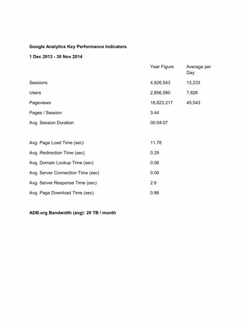
Google Analytics Key Performance Indicators
1 Dec 2013 - 30 Nov 2014
Year Figure Average per
Day
Sessions 4,826,543 13,233
Users 2,856,580 7,826
Pageviews 16,623,217 45,543
Pages / Session 3.44
Avg. Session Duration 00:04:07
Avg. Page Load Time (sec) 11.78
Avg. Redirection Time (sec) 0.29
Avg. Domain Lookup Time (sec) 0.06
Avg. Server Connection Time (sec) 0.06
Avg. Server Response Time (sec) 2.6
Avg. Page Download Time (sec) 0.86
ADB.org Bandwidth (avg): 20 TB / month
26. It is important to note that the Website team will be procuring a CDN for the ADB website
starting in January. This is a consideration for Development Gateway to ensure that the
application can be potentially compliant with a CDN in the future.
27. Regarding hosting, OIST is planning to create an internal cloud service to host all ADB-
related servers, including the website in the future. This would potentially be where the mapping
application server would be hosted as well. No further action is currently needed, as the
mapping application server will be hosted and contained within a single server, regardless of
whether it is hosted at ADB or with a third party.
28. It was also proposed that the information on the map will be populated from the ADB
IATI feed, which is currently updated on a quarterly basis, but may in the future be updated
monthly. As a way to identify to the user where the map data is being populated from, a marker,
such as “data as of x date”, will be incorporated with the map to disclose the timeliness of this
data. The website team currently updates the data on the PDS daily but there are plans to move
this to a bimonthly update. However, even with more frequent IATI publications, the website will
still be updated more often than the map and there will be a need to ensure that there is a
disclaimer for this difference. In addition, TA and NSO projects will not be included in the map,
as they are currently not included in ADB’s IATI reporting. This is another difference that needs
to be asserted, either on the map or within the new Operations Tracker, which will also be
populated from ADB IATI data.
VI. PROPOSED DESIGN AND TECHNICAL ARCHITECTURE
29. Given the aforementioned requirements, the following three mock-ups present the
proposed UI designs for each of the various geomapping application “views” – on the map
navigation page, on the various country pages, and lastly, on the each individual project page.
The default basemap will be Esri Streets map, which is what the World Bank uses as well on its
website. Furthermore, a legal disclaimer will appear below the map to ensure that disputed
country borders are not a reflection of ADB’s views and policies. The exact wording of the
disclaimer will be agreed upon with SPD.
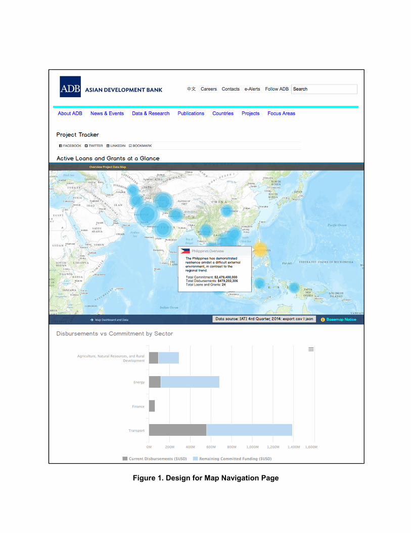
Figure 1. Design for Map Navigation Page
30. Interactive (e.g. can zoom in and out, pan, etc.) map that has bubbles overlaid on each
ADB DMC. Clicking on the bubble brings up a pop-up box that shows: the country name, total
actual ADB commitments to that country, the total number of ADB projects in that country, a link
to the country’s country page, and a link that shows the complete project list for that country.
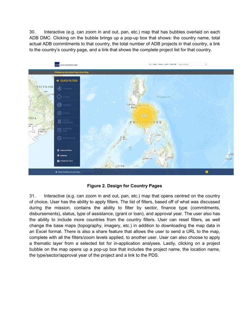
Figure 2. Design for Country Pages
31. Interactive (e.g. can zoom in and out, pan, etc.) map that opens centred on the country
of choice. User has the ability to apply filters. The list of filters, based off of what was discussed
during the mission, contains the ability to filter by sector, finance type (commitments,
disbursements), status, type of assistance, (grant or loan), and approval year. The user also has
the ability to include more countries from the country filters. User can reset filters, as well
change the base maps (topography, imagery, etc.) in addition to downloading the map data in
an Excel format. There is also a share feature that allows the user to send a URL to the map,
complete with all the filters/zoom levels applied, to another user. User can also choose to apply
a thematic layer from a selected list for in-application analyses. Lastly, clicking on a project
bubble on the map opens up a pop-up box that includes the project name, the location name,
the type/sector/approval year of the project and a link to the PDS.
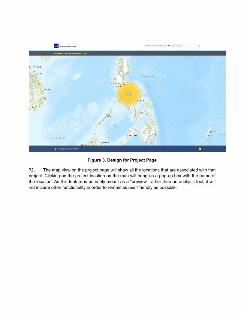
Figure 3. Design for Project Page
32. The map view on the project page will show all the locations that are associated with that
project. Clicking on the project location on the map will bring up a pop-up box with the name of
the location. As this feature is primarily meant as a “preview” rather than an analysis tool, it will
not include other functionality in order to remain as user-friendly as possible.
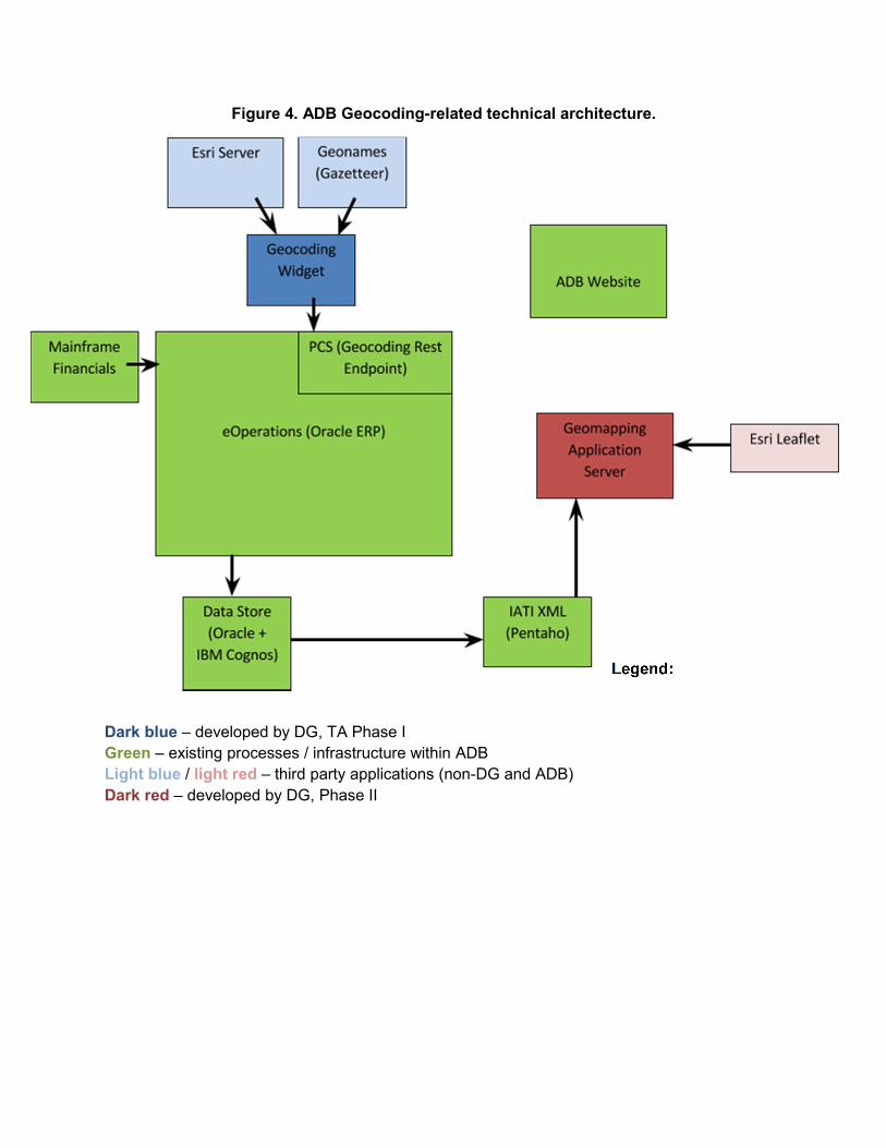
Figure 4. ADB Geocoding-related technical architecture.
Legend:
Dark blue – developed by DG, TA Phase I
Green – existing processes / infrastructure within ADB
Light blue / light red – third party applications (non-DG and ADB)
Dark red – developed by DG, Phase II
33. The figure above shows the overall architecture of ADB’s infrastructure, with regards to
the geocoding widget and geomapping application. Two important things to note are all the
green boxes are existing processes / infrastructure within ADB. The geocoding widget (dark
blue) is also now an existing application within ADB’s infrastructure. The lighter blue boxes
associated with it (Esri server and Geonames) are an integral part to its functioning but are not
applications that Development Gateway has developed. The geomapping application (dark red)
will be developed under the current TA, and as seen from the diagram, has no internal
dependencies on the ADB architecture. Other than the use of the IATI publications (which are
publicly available on ADB’s website), as well as the references to Esri’s open source Leaflet, it
is a stand-alone application that will be referenced by ADB’s website, via its embedding in
various ADB website pages.
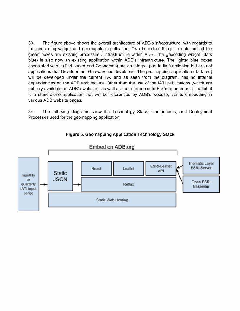
34. The following diagrams show the Technology Stack, Components, and Deployment
Processes used for the geomapping application.
Figure 5. Geomapping Application Technology Stack
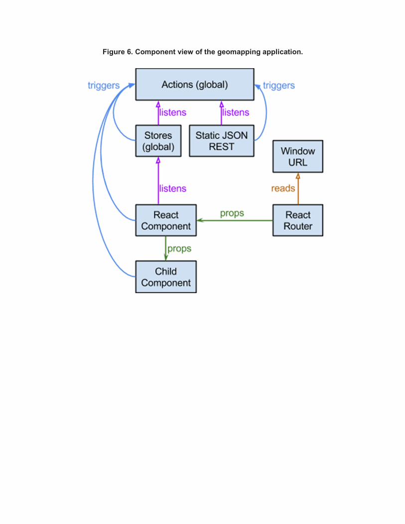
Figure 6. Component view of the geomapping application.
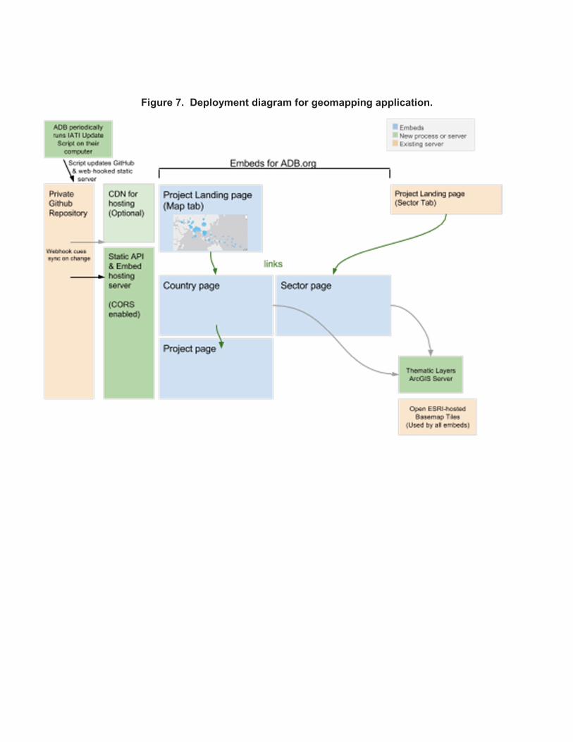
Figure 7. Deployment diagram for geomapping application.
35. The application consists of four essential embed modes: Project Landing page, Country page, Sector page, and Project Page. The input data for the embed pages is built using a script that ADB consultants or staff will run on the same schedule as IATI updates. When that script is run, it will upload its results to a private git repository hosted on GitHub. 36. The web server and/or CDN will get a webhook notification and synchronize their static contents with the git repository, either updating the data of the same script or providing a new version with embed URL, depending on the options. 37. ADB’s DER will include a single embed snippet in each of the four locations on the ADB.org CMS. The snippet will detect the URL as it loads and display the appropriate map content. The “thematic layer” feature of the Country page and Sector page embeds relies on a Thematic Layer ArcGIS Server. For 2015, this will also be hosted by Development Gateway however further arrangements may be made for the future to utilize ADB’s existing ArcGIS Server licenses starting in 2016. 38. The technologies and libraries used in the geomapping application are the following. It is important to note familiarity with these technologies and libraries is necessary for any potential hand-over of maintenance tasks between DG and ADB:
a. browserify is a code build-system for including javascript code as a module rather than as many <script> tags and packaging it up into a single embeddable resource.
b. react is the Javascript Component User Interface (UI) framework to support Javascript Expressions (JSX), created and open sourced by Facebook.
c. JSX is a way of writing Javascript that looks and functions much like HTML but which can be easily inlaid with other Javascript.
d. react router does some magic to map URLs to views of the app, rendering the correct components.
e. reflux is a javascript client-side system that allows event and data flow via Actions and Stores.
f. leaflet is a modern open-source JavaScript library for mobile-friendly interactive maps.
g. jest is a system created by Facebook building on the open source community and is used to support unit tests.
VII. UPDATES TO INCEPTION REPORT BASED OFF OF FEEDBACK FROM MAY 8
GEOMAPPING WORKING GROUP MEETING
39. The following points of feedback were provided during the Geomapping Working Group
Meeting for DG to further delve into and clarify. DG’s responses to each feedback point is in
bold below:
40. On geocoding, S. Jarvenpaa requested Development Gateway (DG) to specify in
the inception report the scope and coverage of ADB projects to be geocoded by DG under the
current TA.
a. During the current TA, ADB-financed operations approved from April to October
2014, including TAs and nonsovereign projects, will be geocoded
b. During the prior TA, ADB’s loan and grant operations, approved and either closed
in 2013 or not closed as of April 2014, financed by the Ordinary Capital Resources
(OCR) and the Special Funds, including the Asian Development Fund (ADF) were
geocoded by DG. TA projects approved between January 2013 and April 2014
were also geocoded.
41. WG members were curious about the type/source of the basemaps and socioeconomic
data layers that will be used for the application. DG informed that the basemaps come from the
same source as the World Bank's geomapping tool. S. Jarvenpaa requested DG to add detailed
explanation about the maps and data layers, including their availability and consistency, in a
revised inception report.
a. The basemaps used on the geomapping application are an open-source, free of
charge resource provided by Esri – one of the leading global providers of
geospatial information services and tools.
b. The attached matrix shows the availability of geospatial population data by ADB
DMC published by WorldPop, an online geospatial population data provider who
has the most comprehensive dataset that spans across most ADB DMCs.
c. Regarding the addition of additional thematic layers, the geomapping application
can support further layers being added, as long as information is provided in a
shapefile and has information by subnational ADM1 or ADM2 divisions. Precise
Longitude/Latitude point information on other donor projects would also satisfy this
criteria.
42. DG explained that it will provide technical documentation about the embedding, server
specs, etc. to facilitate takeover by ADB of the hosting/maintenance of the GIS applications. S.
Jarvenpaa requested DG to elaborate in a revised inception report on embedding/transfer plan,
and also indicate when and what kind of technical documents will be submitted to ADB.
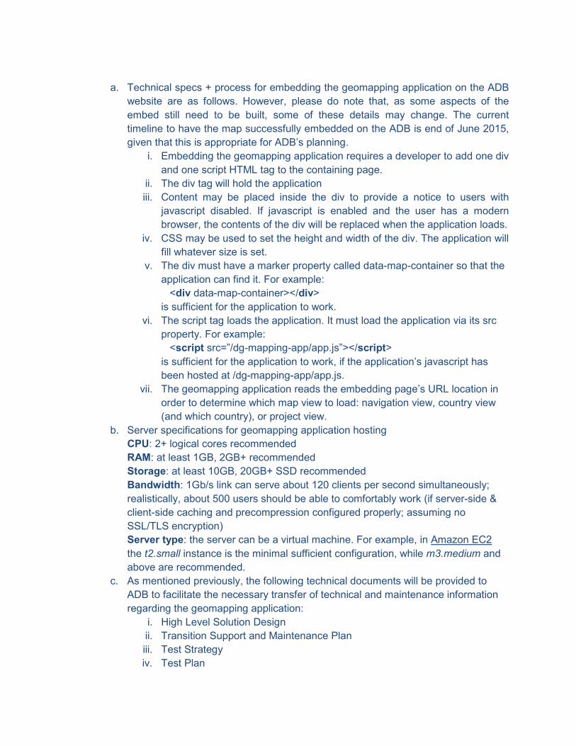
a. Technical specs + process for embedding the geomapping application on the ADB
website are as follows. However, please do note that, as some aspects of the
embed still need to be built, some of these details may change. The current
timeline to have the map successfully embedded on the ADB is end of June 2015,
given that this is appropriate for ADB’s planning.
i. Embedding the geomapping application requires a developer to add one div
and one script HTML tag to the containing page.
ii. The div tag will hold the application
iii. Content may be placed inside the div to provide a notice to users with
javascript disabled. If javascript is enabled and the user has a modern
browser, the contents of the div will be replaced when the application loads.
iv. CSS may be used to set the height and width of the div. The application will
fill whatever size is set.
v. The div must have a marker property called data-map-container so that the
application can find it. For example:
<div data-map-container></div>
is sufficient for the application to work.
vi. The script tag loads the application. It must load the application via its src
property. For example:
<script src=”/dg-mapping-app/app.js”></script>
is sufficient for the application to work, if the application’s javascript has
been hosted at /dg-mapping-app/app.js.
vii. The geomapping application reads the embedding page’s URL location in
order to determine which map view to load: navigation view, country view
(and which country), or project view.
b. Server specifications for geomapping application hosting
CPU: 2+ logical cores recommended
RAM: at least 1GB, 2GB+ recommended
Storage: at least 10GB, 20GB+ SSD recommended
Bandwidth: 1Gb/s link can serve about 120 clients per second simultaneously;
realistically, about 500 users should be able to comfortably work (if server-side &
client-side caching and precompression configured properly; assuming no
SSL/TLS encryption)
Server type: the server can be a virtual machine. For example, in Amazon EC2
the t2.small instance is the minimal sufficient configuration, while m3.medium and
above are recommended.
c. As mentioned previously, the following technical documents will be provided to
ADB to facilitate the necessary transfer of technical and maintenance information
regarding the geomapping application:
i. High Level Solution Design
ii. Transition Support and Maintenance Plan
iii. Test Strategy
iv. Test Plan
v. User Guide
43. S. Jarvenpaa asked DG to provide options for hosting/maintenance taking into account
cost/resource implications based on market rates, etc.
a. Discussions are currently underway with OIST on server requirements as well as
cloud server options such that ADB would be well-poised to take over the handover
of the geomapping application after 2015.
b. The following list gives an overview of the necessary resources and skills needed
for any ADB personnel involved in the maintenance of the geomapping application.
i. GIS Specialist profile
1. Ability to find, evaluate, process, and publish high-quality geospatial
layers using desktop GIS software. Basic cartographic skills to
ensure the publication of attractive layers that match ADB theming
and design of geomapping portal. Ability to do basic administration
of ArcGIS Server (e.g. publication of services, restarting services,
making layers public/private). This Specialist would also support
Country Offices when questions regarding geocoding or geospatial
data collection are raised. Depending upon the ambitions of ADB to
include statistical layers throughout its geomapping work, and the
anticipated level of Country Office support, this would likely be a full-
time role.
ii. Developer profile
1. Ability program in JavaScript with familiarity of functional
programming patterns and Single Page Applications. Basic
familiarity with the Python programming language for the
preprocessing script, and basic shell scripting for the download
script. Familiarity with the Git version control tool.
iii. Systems administrator profile
1. Work experience with any RedHat-like Linux distribution (RHEL,
CentOS, Fedora, Scientific etc). Experience in configuring the
following software: Nginx web server (configuring forward proxying,
compression, caching, headers), SSH server, fail2ban, any backup
system (e.g. Bacula, AMANDA, Duplicity), LVM, YUM. Using
OpenSSL to generate public/private key pair and certificate signing
request. Experience in Linux networking, understanding how HTTP
and SSL/TLS layers work.
VIII. WORKPLAN, RESPONSIBILITIES, AND NEXT STEPS
45. The following list indicates all deliverables under this TA, their status of completion, as
well as any actions that need to take place:
Description Necessary Actions Responsibility Target Date Status of
Completion
Kick-off trip ● DG team to travel to Manila to gather requirements for the geomapping application
● Meet with any and all necessary stakeholders while in Manila, to ensure both technical and user requirements are captured
● SPD, DER, OIST, DG
● Early December 2015
Completed
Inception report ● DG team to provide a thorough document listing out
● Provide report for ADB’s review prior to development and use that as the basis for developing the geomapping application
● DG, SPD ● Early January 2015
Completed
Geocoding ● Second batch of
geocoded data to
be provided by
early January
● Provide the
project
information
necessary for
geocoders to
finalise dataset
● Dong-Ick ● Early
January
2015
Completed
Geomapping
tool
development
● Review and
feedback on
requirements
● Correction by
text to be made
on inception
report and
provided back to
DG
● Telco scheduled
as necessary
● SPD,
DER,
OIST, DG
● Early
January
2015
Completed
● Technical specs
for the server to
be sent to DG
● Provide and
confirm the
specifications for
the server for the
geomapping
application
● OIST, DG ● Early
January
2015
Completed
● Creation of demo
versions, to show
progress to ADB
and gather
iterative feedback
● Provide demo on
a bimonthly basis
in the lead-up to
the May 8
prototype
● DG ● Bimonthly,
starting
February
2015 to
May 8 2015
Completed
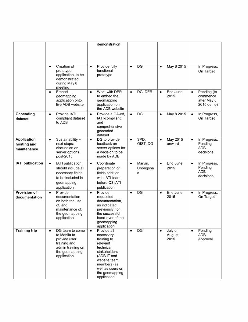
demonstration
● Creation of prototype application, to be demonstrated during May 8 meeting
● Provide fully functional prototype
● DG ● May 8 2015 In Progress,
On Target
● Embed geomapping application onto live ADB website
● Work with DER to embed the geomapping application on the ADB website
● DG, DER ● End June 2015
● Pending (to commence after May 8 2015 demo)
Geocoding
dataset
● Provide IATI compliant dataset to ADB
● Provide a QA-ed, IATI-compliant, and comprehensive geocoded dataset
● DG ● May 8 2015 ● In Progress, On Target
Application
hosting and
maintenance
● Sustainability + next steps: discussion on server options post-2015
● DG to provide feedback on server options for a decision to be made by ADB
● SPD, OIST, DG
● May 2015 onward
● In Progress, Pending ADB decisions
IATI publication ● IATI publication
should include all
necessary fields
to be included in
geomapping
application
● Coordinate
preparation of
fields addition
with IATI team
before Q3 IATI
publication
● Marvin,
Chongsha
n
● End June
2015
● In Progress, Pending ADB decisions
Provision of
documentation
● Provide documentation on both the use of, and maintenance of, the geomapping application
● Provide requested documentation, as indicated previously, for the successful hand-over of the geomapping application
● DG ● End June 2015
● In Progress, On Target
Training trip ● DG team to come to Manila to provide user training and admin training on the geomapping application
● Provide all necessary training to relevant technical stakeholders (ADB IT and website team members) as well as users on the geomapping application
● DG ● July or August 2015
● Pending ADB Approval
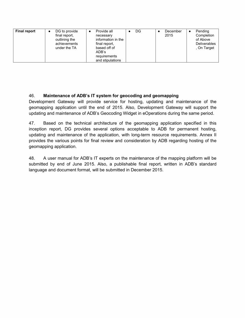
Final report ● DG to provide final report, outlining the achievements under the TA
● Provide all necessary information in the final report, based off of ADB’s requirements and stipulations
● DG ● December 2015
● Pending Completion of Above Deliverables, On Target
46. Maintenance of ADB’s IT system for geocoding and geomapping
Development Gateway will provide service for hosting, updating and maintenance of the
geomapping application until the end of 2015. Also, Development Gateway will support the
updating and maintenance of ADB’s Geocoding Widget in eOperations during the same period.
47. Based on the technical architecture of the geomapping application specified in this
inception report, DG provides several options acceptable to ADB for permanent hosting,
updating and maintenance of the application, with long-term resource requirements. Annex II
provides the various points for final review and consideration by ADB regarding hosting of the
geomapping application.
48. A user manual for ADB’s IT experts on the maintenance of the mapping platform will be
submitted by end of June 2015. Also, a publishable final report, written in ADB’s standard
language and document format, will be submitted in December 2015.
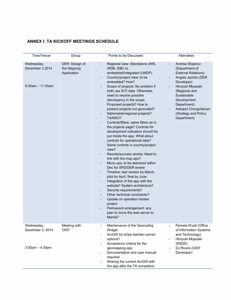
ANNEX I: TA KICKOFF MEETINGS SCHEDULE
Time/Venue Group Points to be Discussed Attendees
Wednesday,
December 3 2014
9:30am – 11:30am
DER: Design of
the Mapping
Application
- Regional view: Standalone (WB,
AfDB, IDB) vs.
embedded/integrated (UNDP)
- Country/project view: to be
embedded? How?
- Scope of projects: No problem if
both use IATI data. Otherwise,
need to resolve possible
discrepancy in the scope.
Proposed projects? How to
present projects not geocoded?
- Nationwide/regional projects?
TA/NSO?
- Controls/filters: same filters as in
the projects page? Controls for
development indicators should be
put inside the app. What about
controls for operational data?
Same controls in country/project
view?
- Results/success stories: Need to
link with the map app?
- Mock-ups: to be delivered within
Dec for SPD/DER review
- Timeline: test version by March,
pilot by April, final by June
- Integration of the app with the
website? System architecture?
- Security requirements?
- Other technical constraints?
- Update on operation tracker
project
- Permanent arrangement: any
plan to move the web server to
Manila?
- Andrea Stojanov
(Department of
External Relations)
- Angelo Jacinto (DER
Developer)
- Hiroyuki Miyazaki
(Regional and
Sustainable
Development
Department)
- Aekapol Chongvilaivan
(Strategy and Policy
Department)
Wednesday,
December 3, 2014
3:00pm – 4:30pm
Meeting with
OIST - Maintenance of the Geocoding
Widget
- ArcGIS for eOps test/dev server:
options?
- Acceptance criteria for the
geomapping app
- Documentation and user manual
required
- Sharing the current ArcGIS with
the app after the TA completion
- Pamela Wyatt (Office
of Information Systems
and Technology)
- Hiroyuki Miyazaki
(RSDD)
- DJ Rivera (OIST
Developer)
- Other requirements in case of
possible take-over of the app
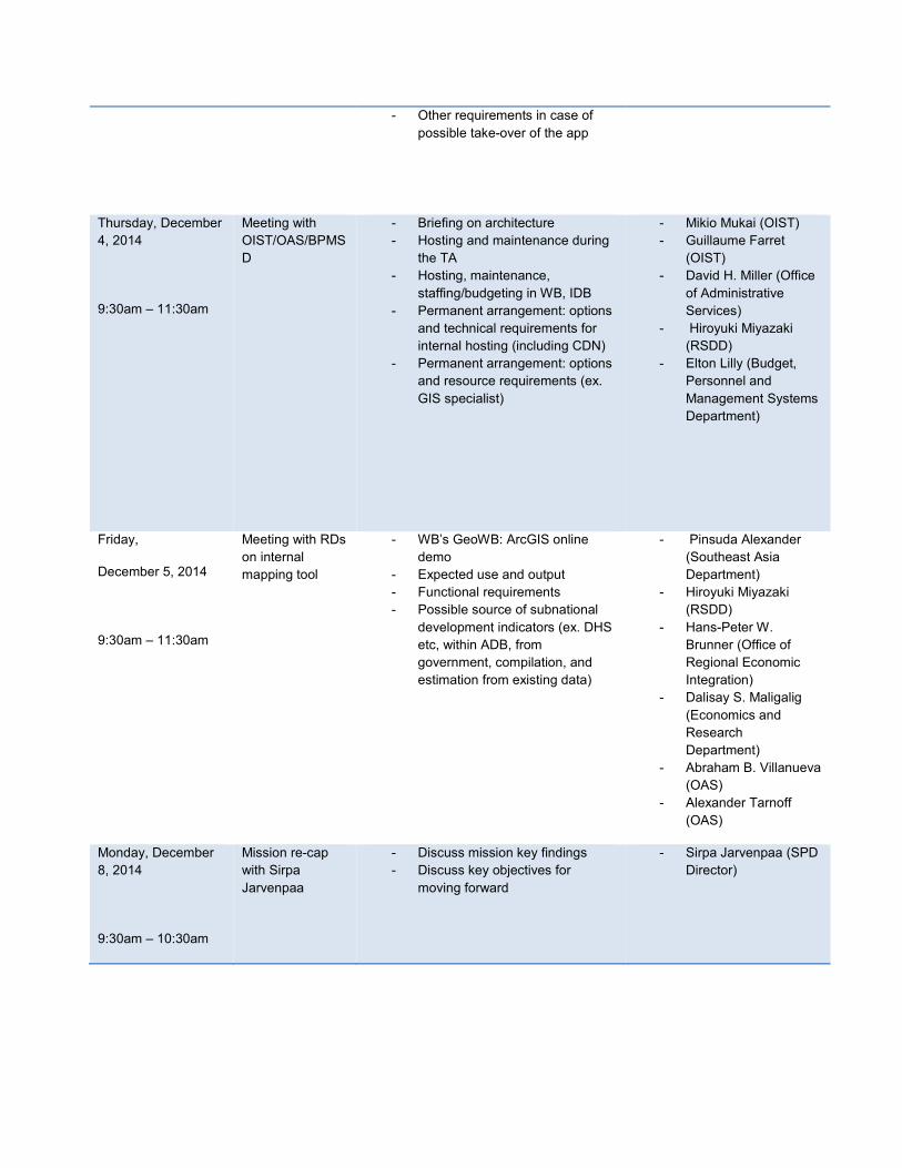
Thursday, December
4, 2014
9:30am – 11:30am
Meeting with
OIST/OAS/BPMS
D
- Briefing on architecture
- Hosting and maintenance during
the TA
- Hosting, maintenance,
staffing/budgeting in WB, IDB
- Permanent arrangement: options
and technical requirements for
internal hosting (including CDN)
- Permanent arrangement: options
and resource requirements (ex.
GIS specialist)
- Mikio Mukai (OIST)
- Guillaume Farret
(OIST)
- David H. Miller (Office
of Administrative
Services)
- Hiroyuki Miyazaki
(RSDD)
- Elton Lilly (Budget,
Personnel and
Management Systems
Department)
Friday,
December 5, 2014
9:30am – 11:30am
Meeting with RDs
on internal
mapping tool
- WB’s GeoWB: ArcGIS online
demo
- Expected use and output
- Functional requirements
- Possible source of subnational
development indicators (ex. DHS
etc, within ADB, from
government, compilation, and
estimation from existing data)
- Pinsuda Alexander
(Southeast Asia
Department)
- Hiroyuki Miyazaki
(RSDD)
- Hans-Peter W.
Brunner (Office of
Regional Economic
Integration)
- Dalisay S. Maligalig
(Economics and
Research
Department)
- Abraham B. Villanueva
(OAS)
- Alexander Tarnoff
(OAS)
Monday, December
8, 2014
9:30am – 10:30am
Mission re-cap
with Sirpa
Jarvenpaa
- Discuss mission key findings
- Discuss key objectives for
moving forward
- Sirpa Jarvenpaa (SPD
Director)
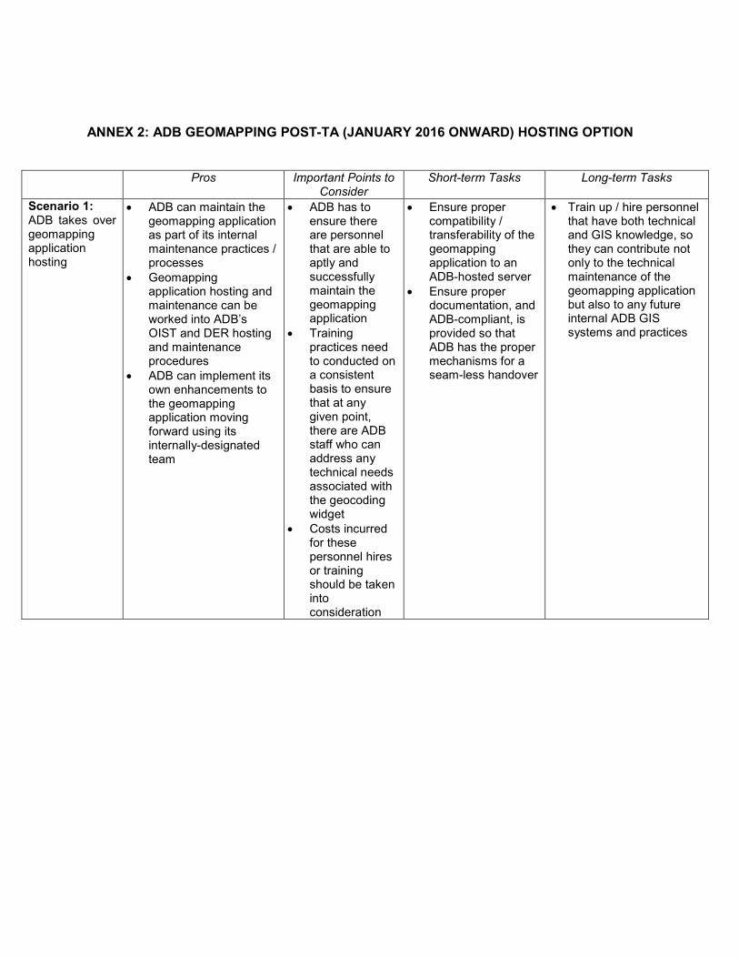
ANNEX 2: ADB GEOMAPPING POST-TA (JANUARY 2016 ONWARD) HOSTING OPTION
Pros Important Points to Consider
Short-term Tasks Long-term Tasks
Scenario 1: ADB takes over geomapping application hosting
• ADB can maintain the geomapping application as part of its internal maintenance practices / processes
• Geomapping application hosting and maintenance can be worked into ADB’s OIST and DER hosting and maintenance procedures
• ADB can implement its own enhancements to the geomapping application moving forward using its internally-designated team
• ADB has to ensure there are personnel that are able to aptly and successfully maintain the geomapping application
• Training practices need to conducted on a consistent basis to ensure that at any given point, there are ADB staff who can address any technical needs associated with the geocoding widget
• Costs incurred for these personnel hires or training should be taken into consideration
• Ensure proper compatibility / transferability of the geomapping application to an ADB-hosted server
• Ensure proper documentation, and ADB-compliant, is provided so that ADB has the proper mechanisms for a seam-less handover
• Train up / hire personnel that have both technical and GIS knowledge, so they can contribute not only to the technical maintenance of the geomapping application but also to any future internal ADB GIS systems and practices
Recommended