Restoration measures to improve river habitats during low flows
Report SC120050/R

ii Restoration measures to improve river habitats during low flows
We are the Environment Agency. We protect and improve the environment and make it a better place for people and wildlife.
We operate at the place where environmental change has its greatest impact on people’s lives. We reduce the risks to people and properties from flooding; make sure there is enough water for people and wildlife; protect and improve air, land and water quality and apply the environmental standards within which industry can operate.
Acting to reduce climate change and helping people and wildlife adapt to its consequences are at the heart of all that we do.
We cannot do this alone. We work closely with a wide range of partners including government, business, local authorities, other agencies, civil society groups and the communities we serve.
This report is the result of research commissioned and funded by the Environment Agency.
Published by: Environment Agency, Horizon House, Deanery Road, Bristol, BS1 5AH www.gov.uk/government/organisations/environment-agency ISBN: 978-1-84911-382-3 © Environment Agency – September 2016 All rights reserved. This document may be reproduced with prior permission of the Environment Agency. The views and statements expressed in this report are those of the author alone. The views or statements expressed in this publication do not necessarily represent the views of the Environment Agency and the Environment Agency cannot accept any responsibility for such views or statements. Further copies of this report are available from our publications catalogue: www.gov.uk/government/publications or our National Customer Contact Centre: T: 03708 506506 Email: [email protected]
Author(s): Sebastian Bentley, Judy England, Claire Bithell, David Mould, Helen Reid Dissemination Status: Publicly available Keywords: Geomorphology, hydromorphology, ecology, habitat, restoration, modelling, typology, scale Research Contractor: JBA Consulting The Library, St Philip’s Courtyard, Church Hill, Coleshill, B46 3AD 01675 437750 Environment Agency’s Project Manager: Judy England, Evidence Directorate

Restoration measures to improve river habitats during low flows iii
Evidence at the Environment Agency Evidence underpins the work of the Environment Agency. It provides an up-to-date understanding of the world about us, helps us to develop tools and techniques to monitor and manage our environment as efficiently and effectively as possible. It also helps us to understand how the environment is changing and to identify what the future pressures may be.
The work of the Environment Agency’s Evidence Directorate is a key ingredient in the partnership between research, guidance and operations that enables the Environment Agency to protect and restore our environment.
This report was produced by the Scientific and Evidence Services team within Evidence. The team focuses on four main areas of activity:
Setting the agenda, by providing the evidence for decisions;
Maintaining scientific credibility, by ensuring that our programmes and projects are fit for purpose and executed according to international standards;
Carrying out research, either by contracting it out to research organisations and consultancies or by doing it ourselves;
Delivering information, advice, tools and techniques, by making appropriate products available.
Miranda Kavanagh
Director of Evidence

iv Restoration measures to improve river habitats during low flows
Executive summary The requirement to achieve good ecological status in rivers, along with the potential impacts from climatic change, has emphasised the need for the Environment Agency to have a better understanding of the dynamic nature of catchments for river basin planning, targeting improvement measures and preventing deterioration in ecological quality.
Physical modification was reported in the first river basin management plans as one of the top 3 reasons why water bodies are not currently at good ecological status. Restoring natural river processes at various scales will be required to meet Water Framework Directive objectives. Improving the current condition of rivers will also improve resilience to future pressures like climate change.
River channels need to be able to accommodate floods and to provide good quality habitats at low flow conditions. Ecological communities in modified channels are known to be less resilient to low flows. Improving the morphological condition of river channels is likely to increase ecological adaptive capacity and resilience to future changes. However, a lack of effective monitoring and reporting of the impacts of river restoration means that understanding of the performance of many restoration measures under low flow conditions is inconclusive or absent.
To help address this knowledge gap, the Environment Agency has carried out a modelling study to generate information about how some potentially useful measures might improve in-channel habitats during low flows while also being robust to high flows.
Following a review of previously reported assessments and case studies, 5 restoration measures were selected for further study: assisted natural recovery; embankment removal; weir removal; re-meandering; and reconnection of an old palaeochannel. Information from light detection and ranging (LiDAR) and aerial imagery was used to create digital elevation models on which hydraulic models could be run to define hydraulic habitat patches (areas of different velocities) and compare restoration measures with control sections (either degraded sections on the same watercourse, or pre restoration conditions). The approaches were tested in real river locations where the measures had previously been implemented and, in one case, to assess the likely effects of implementation.
A further objective was to determine whether the findings would apply to other locations. To do this the river type for each case study was classified. Seven broad categories of river types were identified based on existing classifications in use elsewhere. These provide a high level framework for considering whether measures were likely to be effective in different river types and where benefits would not be realised.
Main findings from the case studies
Assisted natural recovery was successful in restoring hydromorphological processes. It increased hydraulic habitat diversity and habitat connectivity, and created flowing water refugia under low flow conditions. This demonstrated that it was a suitable measure to increase ecological resilience in wandering rivers.
Modelling the impact of flood embankment removal in a wandering river did not result in any change in habitat provision under low flow conditions. This is likely to be due to the bank protection continuing to constrain the channel

Restoration measures to improve river habitats during low flows v
and emphasises the importance of restoring geomorphic processes as well as changing channel form.
Weir removal in an active single thread system restored hydromorphological processes and increased the presence of faster flowing biotopes and habitat diversity under low flow conditions. This demonstrated that weir removal is a suitable measure to increase ecological resilience and also improve longitudinal connectivity.
The re-meandering of a low energy, passive single thread river did not increase habitat diversity or create flowing water refugia under low flow conditions. Meandering and increasing channel length within low energy systems is unlikely to increase ecological resilience under low flows. It is likely to be more successful in more active systems.
The palaeochannel reconnection in an active single thread river type showed no observable change in habitat under low flow conditions in the short term. Reconnecting channels in active systems, which are allowed to adjust, have the potential to increase ecological resilience at low flows over time.
Conclusions and recommendations
The case study assessments demonstrated the importance of the correct identification of the river type (forms and processes) when selecting suitable restoration measures to improve habitat conditions under low flows and to ensure they remain functional and sustainable in the short and long term. Restoring hydromorphological processes is crucial in increasing the sustainability of schemes, and greatly influences the rate of channel response and timescales of recovery or improvement in the affected habitat.
The modelling approach used in this study can help to evaluate potential impacts on large sections of river in a cost-effective way and at a high resolution. Modelling can be used to help to identify suitable locations for restoration and to evaluate potential success without having to conduct resource-intensive field studies, though these may help to validate model results.
A matrix was developed to summarise current understanding about the effectiveness of a range of restoration measures and how well they might work in a range of river types or locations. This is based partly on expert judgement but, where relevant studies existed, it was possible to provide greater confidence in the assessment. Confidence assessments can be updated as more information becomes available, particularly about how river ecosystems respond to hydromorphological change over time.
The review of current understanding indicates low confidence in the effectiveness of several measures and evidence gaps for:
assessments of catchment scale measures
the application of measures in higher energy systems
long-term impacts
Further targeted studies would help to improve understanding of how plants and animals respond to hydromorphological measures. Greater confidence in the effectiveness of restoration measures may support their wider uptake and lead to better environmental outcomes.

vi Restoration measures to improve river habitats during low flows
Contents 1 Introduction 8
1.1 Introduction 8
1.2 Background 9
1.3 Project aims 10
1.4 Report structure 10
2 Methods 11
2.1 Identification of morphological measures 11
2.2 Selection of case studies 12
2.3 Modelling methodology 14
2.4 Development of a matrix for targeting measures 15
3 Review of morphological measures 17
4 Case study assessments 30
4.1 Assisted natural recovery in a wandering river 30
4.2 Flood bank removal in a wandering river 38
4.3 Weir removal in a wandering river 43
4.4 Re-meandering of a passive single thread river 51
4.5 Palaeochannel reconnection in an active single thread river 59
4.6 Discussion 65
5 Guide to selecting restoration measures 67
5.1 About the matrix 67
5.2 Discussion 70
6 Conclusions 72
References 73
List of abbreviations 83
Appendices 84
Table 2.1 Hydraulic biotopes 12 Table 3.1 Review of restoration measures to improve river habitats during low flows 19 Table 4.1 Selected case studies 30 Table 4.2 Review of refugia available under bankfull conditions 37 Table 4.3 Review of refugia available under bankfull conditions 43 Table 4.4 Refugia availability under bankfull conditions 50 Table 4.5 Refugia availability under bankfull conditions for the Skerne at Darlington 57 Table 4.6 Refugia availability under bankfull conditions for the Ribble 64 Table 5.2 Key to sources cited in the matrix (Table 5.1) 68 Table 5.1 Guide of application of measures to improve low flow conditions 69 Figure 3.1 Summary of potential measures to improve river habitats during low flows 29 Figure 4.1 Study reach locations for the River Wharfe 31 Figure 4.2 Gravel/cobble bar development at study reach 32

Restoration measures to improve river habitats during low flows vii
Figure 4.3 Reach scale hydraulic habitat diversity under low flow conditions: River Wharfe – bank protection failure/assisted natural recovery 33
Figure 4.4 Reach scale hydraulic habitat diversity under high flow conditions: River Wharfe– bank protection failure/assisted natural recovery 34
Figure 4.5 Reach scale brown trout habitat suitability under low flow conditions: River Wharfe – bank protection failure/assisted natural recovery 35
Figure 4.6 Reach scale brown trout habitat suitability under low flow conditions: River Wharfe – bank protection failure/assisted natural recovery 36
Figure 4.7 Reach scale brown trout habitat suitability refugia habitat at high flows: River Wharfe – bank protection failure/assisted natural recovery 37
Figure 4.8 Study reach location for the River Wharfe 38 Figure 4.9 Low energy pools and glides in the constrained channel 39 Figure 4.10 Reach scale hydraulic habitat diversity under low flow conditions: River Wharfe – embankment removal40 Figure 4.11 Reach scale hydraulic habitat diversity under high flow conditions: River Wharfe – embankment removal41 Figure 4.12 Reach scale brown trout habitat suitability under low flow conditions: River Wharfe – flood bank removal42 Figure 4.13 Location of Prestolee Weir on the River Irwell 44 Figure 4.14 Site of Prestolee Mill Weir on the River Irwell 45 Figure 4.15 Hydraulic habitat diversity under low flow conditions: River Irwell 45 Figure 4.16 Hydraulic habitat diversity under high flows: River Irwell 46 Figure 4.17 Habitat suitability under low flow conditions: River Irwell 48 Figure 4.18 Reach scale brown trout habitat suitability under low flow conditions: River Irwell 49 Figure 4.19 Reach scale brown trout habitat suitability under low flow conditions: River Irwell 50 Figure 4.20 Location of River Skerne study site 52 Figure 4.21 Aerial imagery of River Skerne at Darlington 52 Figure 4.22 Hydraulic habitat diversity under low flow conditions: River Skerne 53 Figure 4.23 Hydraulic habitat diversity at high flows: River Skerne 54 Figure 4.24 Habitat suitability under low flow conditions: River Skerne 56 Figure 4.25 Reach scale brown trout habitat suitability under low flow conditions: River Skerne 57 Figure 4.26 Refugia habitat under bankfull conditions: River Skerne 58 Figure 4.27 Location of River Ribble study site 60 Figure 4.28 Aerial imagery of the River Ribble study site 60 Figure 4.29 Hydraulic habitat diversity under low flow conditions: River Ribble 61 Figure 4.30 Hydraulic habitat diversity under high flows: River Ribble 62 Figure 4.31 Shear stress variability under high flows: River Ribble 63 Figure 4.32 Habitat suitability under low flow conditions: River Ribble 63

8 Restoration measures to improve river habitats during low flows
1 Introduction
1.1 Introduction
In 2010 only 24% of rivers in England were at good (or better) status (Environment Agency 2011), with morphological issues contributing to 44% of the failures. Restoration of many of our river systems, at various scales, will be required to improve their hydromorphological condition to ensure Water Framework Directive (WFD) status objectives are met. However, the ability to achieve good status will be increasingly difficult as a result of the impacts of climate change.
Concern about changes in future river flows has focused attention on ensuring that watercourses already at good ecological status/good ecological potential do not become vulnerable to status downgrade. There is so far little evidence of changes in very low flow frequencies, although some studies indicate increases in the magnitude and frequency of short droughts (<18 months) in the future (Watts and Anderson 2013). Improving the condition of rivers will also improve their robustness to pressures created as the climate changes such as low and high flow events. More physically diverse habitats are considered more resilient to extreme events, such as floods and droughts, and recover quicker from disturbances (Townsend and Hildrew 1994, Brown 2003, Dunbar et al. 2010).
Physical modification is one of the top 3 pressures causing the failures reported in the first river basin management plans (other pressures may also impact the same water bodies). In England and Wales, 44% of all water bodies had physical modification pressures identified as a reason for failure (Environment Agency 2012a). It is anticipated that future conditions may bring a greater frequency of both floods and droughts. River systems and the habitat they contain need to be able to accommodate these changes without deterioration in ecological quality.
The animals in modified channels have been shown to be more sensitive to changes in flows and less resilient under low flow conditions (Dunbar et al. 2010). Therefore, improving the morphological condition of river channels is likely to increase adaptive capacity and resilience to future changes. Morphological restoration measures are widely accepted as a complementary approach to abstraction reduction or modification, and can provide sustainable solutions to water resource pressures (Environment Agency 2013a). The morphological restoration measures are implemented to mitigate against historic engineering pressures and to enhance the ecological benefits of increasing the amount of water in rivers, as well as increasing resilience under low flow conditions.
Unfortunately, a lack of effective monitoring and reporting on restoration measures means that the evidence base on the hydromorphic performance of these measures is both patchy and in many cases unscientific, lacking details such as objective setting, survey design, data quality and statistical analysis (see, for example: Palmer et al. 2005, Environment Agency 2008, Vaughan et al. 2009, Feld et al. 2011). This was also recognised by Newson and Large (2006), who reported that interdisciplinary knowledge of river restoration measures and naturalisation remained scant, ‘yet such knowledge is needed at a range of scales from catchment to microhabitat’. The large numbers of unmonitored schemes where risks and benefits are poorly defined act as a barrier to restoration progress through a lack of confidence in the success potential of interventions that might help achieve WFD objectives.
The greatest needs from research are to supply management tools and guidance to help understand the impacts of hydromorphological pressures on ecology and the

Restoration measures to improve river habitats during low flows 9
hydromorphological and ecological response to restoration measures (Newson and Large 2006, Vaughan et al. 2009, Palinkas 2013, Rinaldi et al. 2013). This project begins to address this gap in scientific knowledge and information by providing new evidence of the impact of some potentially useful restoration measures.
1.2 Background
Droughts are a natural disturbance of river systems that influence community structure, altering species composition, abundance and richness, promoting diversity (Atkinson et al. 2014) and favouring specialist species (Mainstone 1999). The impact of drought on ecological communities depends on the duration and intensity of the drought (Wood and Petts 1999, Wood et al. 2000 ). A synthesis of available literature indicates that ‘supra-seasonal’ droughts occurring over several years can result in the loss of key species unable to cope with the conditions (Environment Agency 2013a).
Droughts reduce the volume of available water, resulting in a loss of horizontal, longitudinal and vertical connectivity between the water body and its surroundings. Initially, wetted habitat is lost when the river becomes disconnected from its riparian zone but, as the drought progresses, longitudinal river connectivity may also be lost. In rivers supported by groundwater baseflows, droughts may also cause a loss of vertical connectivity between surface water and groundwater (Environment Agency 2013a).
The presence of refugia1 can mitigate the impacts of drought. For example, some invertebrates may burrow into the gravel where it may still be wet. Fish and mobile invertebrates may migrate to deeper areas as flows decline. Here they may become isolated, temperatures may increase and oxygen levels may decrease, and if conditions persist, the channel will dry up (Lancaster and Hildrew 1993). Some plants, including algae, survive drying for short periods or longer periods as seeds. Some invertebrates such as crayfish and aquatic beetles can also survive periods of drying. Recovery following a drought depends on the duration and intensity of the drought and the ability of biota to recolonise. Similarly during bankfull conditions when river systems experience the greatest velocities, fish and invertebrates can actively avoid being washed away through the use of refugia such as backwaters, sheltered margins or the river bed (Lancaster and Hildrew 1993).
The spatial pattern of drying and rewetting during low flows is strongly influenced by the morphology of a river. Morphologically diverse sites, with little or no habitat modification, provide refugia and resilience to drying – through a range of flow environments, deeper pools and boulders/logs/plants. Conversely, homogenous river channels are more prone to rapid and total drying, which exacerbates the impacts of drought on biota. As a consequence, reaches characterised by habitat modification are often more sensitive to drought than those that are not (Environment Agency 2013a, Dunbar et al. 2010). As a result morphological restoration can be a very useful intervention for managing water resources (Environment Agency 2013a).
River restoration has changed in approach over recent decades, moving from schemes focusing on re-creating lost physical habitats to schemes which aim to restore natural riverine processes, suited to individual system characteristics. There is recognition that this latter approach is critical to creating and sustaining hydromorphic function and diversity in functioning river ecosystems (see, for example: Newson and Large 2006, Sear et al. 2009, Kristensen et al. 2013).
Restoration measures which work with natural processes can have a wider catchment influence. For example, restoration measures which increase channel roughness and
1 A refugium (plural: refugia) is an area that provides a haven for organisms where they can survive a period of unfavourable conditions.

10 Restoration measures to improve river habitats during low flows
decrease the rate at which water is flushed through the catchment can increase recharge to groundwater (Liu et al. 2004). Detailed assessments of process-based restoration schemes demonstrate how such techniques complement the natural approach to reducing flood risk, which involves taking action to manage fluvial and coastal flood erosion risk by protecting, restoring and emulating the natural regulating function of catchments, rivers, floodplains and coasts (Paul and Meyer 2001, Allan 2004, Feld et al. 2011, Environment Agency 2014).
1.3 Project aims
There is limited evidence to demonstrate which restoration measures are successful under low flow conditions (Environment Agency 2008, UKWIR 2013). The Environment Agency wants to develop the evidence around measures that can be used in a practical way to enhance physical habitats particularly during low flow conditions, but also to ensure they are effective and sustainable at bankfull flows when geomorphic processes are likely to be most active and must contribute to reducing flood risk.
This project evaluated the effectiveness of a range of sustainable measures and enhancements that increase ecological resilience. Its specific objectives were to:
(1) Identify a range of options that either:
a) enhance riparian habitat
b) lead to a more heterogeneous channel bed morphology or
c) create a range of refugia for freshwater organisms during low flows
(2) Illustrate the potential habitat benefits at low flows of a few selected interventions through examination as case studies
(3) Develop criteria that can be used to help target where the measures selected in (2) can potentially be most ecologically effective (NB cost-effectiveness is beyond the scope of this project)
1.4 Report structure
Section 2 outlines the methods used in the study – the identification of morphological measures that may improve ecological resilience, the criteria for case study selection, the modelling methodology adopted and the development of a matrix for targeting measures.
Section 3 presents a review of previously identified morphological measures, leading to the choice of 5 measures for modelling.
Section 4 details the case study assessments of the five selected interventions.
Section 5 presents a matrix that identifies which measures are most likely to improve low flow conditions in a range of river situations.
Section 6 presents conclusions and recommendations for future work.

Restoration measures to improve river habitats during low flows 11
2 Methods
2.1 Identification of morphological measures
A range of morphological measures that either enhance riparian habitat, lead to a more heterogeneous channel bed morphology, or create a range of refugia for freshwater organisms during low flows are available (see Section 3).
Morphological measures that could be used to complement, or as an alternative to, abstraction reduction (that is, improving the robustness of rivers under low conditions and the pressures created as a result of abstraction) have previously been identified by UK Water Industry Research (UKWIR) (UKWIR 2013). This extensive study was used as the basis for the consideration of measures in this project, though some of the categories used (for example, ‘instream measures’) incorporated many different techniques which are considered separately as measures in this report. Measures that operate at a catchment scale such as grip blocking and planting of native woodland were also added.
When identifying appropriate morphological measures, the character and extent of catchment and channel modifications and the potential scale of the effectiveness of the hydromorphological measures were considered. Low flow pressures inherently operate over very large spatial scales and the impacts will depend on the ability of the water body or catchment to adjust hydromorphologically and ecologically. Where the pressure impacts are extensive, catchment scale measures may be needed. In some instances very local modifications can act as ‘bottlenecks’ in a catchment so that their restoration can lead to improvements over a much wider area. Implementing measures in modified systems needs to be considered as part of a more strategic catchment approach in conjunction with other measures.
Process-based restoration aims to reinstate ecological function at the catchment scale through the naturalisation of flow and physical form. To identify common situations where measures identified in this project might be most effective, a modified version of the river classification scheme developed by Montgomery and Buffington (1997) was used as a loose framework to act as a high level guide. Although this is a North American classification system, 7 channel types are broadly similar to natural UK river types (see, for example: Newson 2002, Orr et al. 2008) and it was used to indicate where natural processes may not sustain the measure in some locations. Further detail and examples of the 7 river types ((bedrock, step-pool, plane bed, wandering, active single thread, passive single thread, lowland anastomosed) )are provided in Appendix A.
When designing restoration measures, however, ‘restoration design requires further information on reach-specific characteristics’ (Montgomery and Buffington 1997). The classification is also hard to apply to systems or watercourses that have a high degree of modification (Montgomery and Buffington 1997). For restoration measures which have a high level of intervention to channel dimensions such as changing channel width or removing a barrier, geomorphological expertise is required. Less interventionist measures such as fine sediment control or fencing can be considered less risky and universally applied.

12 Restoration measures to improve river habitats during low flows
2.2 Selection of case studies
Five case studies (see Section 4) were selected to illustrate the habitat benefits at low flows of different morphology measures.
The habitat assessment was made using hydraulic models to assess the composition and distribution of different hydraulic habitats.
The assignment of different hydraulic ranges to define physical habitats (biotopes) is a widely accepted approach to assessment (see, for example, Kemp et al. 2000, Harvey et al. 2008, Harvey and Clifford 2008, Heritage et al. 2009). Mapping of the biotopes allows quantification of habitat area, diversity and patchiness – all of which are important aspects of defining ecological quality, diversity and resilience.
The habitat maps were used to identify the presence and coverage of faster flowing areas during low flow conditions (low flow refugia) and slower flowing or slack areas during higher (bankfull) flows (high flow refugia).
The hydraulic biotopes were defined by the variation of the Froude number (the ratio of inertial to accelerational forces) (see Gordon et al. 1994) The Froude number has been found to be a reliable hydraulic variable to distinguish between different biotopes (see, for example, Wadeson 1994, Kemp et al. 2000, Heritage et al. 2009). The Froude number is calculated as follows:
𝐹𝑟 =𝑣
√𝑔𝑑 (2.1)
where v is flow velocity, g is gravitational acceleration and d is hydraulic depth (Newson et al. 1998).
Table 2.1 lists the biotopes used in this study based on Froude number variation.
Table 2.1 Hydraulic biotopes
Pool
Froude number range: 0.00–0.04
No perceptible flow ~ associated with pools
Glide
Froude number range: 0.04–0.15
Slow flowing, little water surface disruption – mostly associated with glides

Restoration measures to improve river habitats during low flows 13
Run
Froude number range: 0.15–0.24
No waves, but general flow direction is downstream with disturbed rippled surface –
mostly associated with runs
Unbroken standing wave
Froude number range: 0.24–0.49
Upstream facing wavelets which are not broken – mostly associated with riffles
Broken standing wave
Froude number range: 0.49–0.70
Whitewater tumbling waves – mostly associated with rapids
Chute
Froude number range: 0.70–1.50
Low curving fall in contact with substrate – often associated with cascades
Notes: Adapted from Heritage et al. (2009)
Case studies and details of the application of the restoration measures were identified from:
UKWIR evidence review (UKWIR 2013)
RESTORE RiverWiki2
Healthy Catchments3
River Restoration Centre (RRC) Manual of River Restoration Techniques (RRC 2013)
project reports by Jeremy Benn and Associates Limited (JBA)
2 https://restorerivers.eu
3 www.ecrr.org/RiverRestoration/Floodriskmanagement/HealthyCatchmentsmanagingforfloodriskWFD/tabid/3098/Default.aspx

14 Restoration measures to improve river habitats during low flows
published literature
To identify which measures are more effective, case studies were identified where a single measure had been implemented and where there was sufficient data to enable the planned hydraulic modelling approach (see below).
Four of the case studies are where morphological measures have been applied and either pre-implementation information was available or degraded sections could be used to help define pre restoration conditions.
An additional case study was a hypothetical situation to assess:
how a river might change following the implementation of a morphological measure
whether the modelling approach would aid the assessment of its effectiveness
2.3 Modelling methodology
2.3.1 Assessment of hydraulic habitats I: fixed bed hydrodynamic model
Hydraulic habitat mapping was performed using a simulation of low flow conditions and a simulation of bankfull conditions to assess the composition and distribution of biotopes. Light detection and ranging (LiDAR) and aerial imagery were used to create a Digital Elevation Model (DEM) suitable for the purposes of the hydraulic habitat modelling process. A 2-dimensional fixed bed hydrodynamic model, JFLOW+ (Bradbrook 2006) was applied to the DEM and used to assess the presence of different hydraulic biotopes. Using a fixed bed hydraulic model was deemed appropriate since the hydraulic habitat mapping used a simulation of low flow conditions where the hydraulic forces operating are generally insufficient to cause bed or bank erosion or to transport gravel and cobble sized sediment. The modelling of shear stress values was used to provide an indication of the restoration of riverine processes and the potential for future channel adjustment. The data requirements and modelling approach are detailed in Appendix B.
The extremes of flow were used to identify the presence and coverage of faster flowing areas during low flow conditions (low flow refugia) and slower flowing or slack areas during higher (bankfull) flows (high flow refugia). The presence of refugia is considered essential for ecological resilience (see, for example, Lake 2000, Lake 2007, Boulton and Lake 2008). Low flows were modelled using the Q95 flow (that is, the discharge which is exceeded 95% of the time). Bankfull conditions varied according to channel dimensions and flow, but were generally Q10 to Q20 (that is, flows exceeded 10–20% of the time).
For each case study, a comparison of the reach where the morphological measure had been applied was made to either pre-restoration conditions or a nearby degraded section. This gave an indication of how the biotope habitat composition had changed as a result of the scheme.
The constraints are associated with this approach include the following.
The hydraulic model is not a dynamic sediment model and therefore changes to the channel form over time will not be quantified. For example, the impacts of fine sediment management may be better demonstrated in a
Restoration measures to improve river habitats during low flows 15
dynamic sediment model where sediment supply and loads can be quantified.
The modelling process is dependent on the availability of suitable data to adequately model the restoration measure.
The fixed bed model approach assumes that no morphological change will occur during low flow conditions. This is not unreasonable as the hydraulic forces operating are generally insufficient to cause bed or bank erosion. However, it is recognised that the restoration measures will be subject to higher flows, which may alter the channel form and low flow hydraulics over time (see, for example: Newson et al. 2002, Gilvear et al. 2013).
2.3.2 Assessment of hydraulic habitats II: fuzzy logic habitat model
For each case study, a fuzzy logic habitat model (JHAB) was used to assess habitat suitability for fish. The modelling approach, detailed in Appendix B, was used to review the habitat suitability for different life stages of trout and 0+ cyprinid fish, under low flow conditions and refugia at high flows. The habitat suitability was for trout based on available literature for trout (Heggenes 1989, de Crispin de Billy and Usseglio-Polatera 2002, Armstrong et al. 2003). For cyprinid fish, only one life stage was investigated since there is less published information and the adults are often found in a wider range of habitats (Environment Agency 2013c). The 0+ life stage is considered important as the primary control on the year class strength (see, for example: Mann 1995). Refuge assessment at high flows used a general rule based on research on fish swimming speed (Clough and Turnpenny 2001).
The modelling provided a spatial assessment of the channel through the calculation of a Habitat Suitability Index (HSI) for each flow and species/life stage of interest. This was used to assess:
quantity of available habitat – Total Habitat Suitability Index (THSI)
quality of the habitat – Habitat Quality Index (HQI)
The HQI is derived by dividing the THSI by the number of wet cells in the model for that scenario.
Visual assessments were made for the presence of hydraulic refugia at high and low flows, habitat connectivity and patchiness.
2.4 Development of a matrix for targeting measures
In the process of identifying measures for this modelling study, a large amount of information was collated by a team of JBA geomorphologists. These data form the basis of a matrix (Table 5.1) to help guide the selection of appropriate and effective restoration measures for a particular location. This matrix was based largely on the judgement of geomorphologists and ecologists from JBA and the project board.
Although evidence in this area is limited, there are useful and relevant published papers and reports about how effective different measures are in some situations. To make best use of these sources, an additional layer of information was added linking measures to published works and providing an initial confidence assessment. This also helped to identify important evidence gaps.

16 Restoration measures to improve river habitats during low flows
Where data and evidence are available from studies or literature, this provides a level of confidence in the measure achieving the restoration objectives. A higher degree of confidence is given to those situations where there is evidence to support the decision. High confidence is given where there are 2 or more documented case studies, or modelled response for this project, medium confidence for one case study or conflicting evidence, and low for limited evidence.
For the purposes of this study, each measure was considered in isolation to determine its applicability across a range of rivers, scales and flows. Often, 2 or more restoration measures may be applied at the same time. For instance, weir removal could be considered alongside in-channel works to modify the morphology of the channel bed as a result of the increase in hydraulic gradient created by the weir removal.
What is not covered in this study is an assessment of the timescale of recovery. The recovery of geomorphological processes will vary according to river type, the flow regime and the sequence of channel forming events. Ecological changes may take even longer and are influenced by factors such as sources of colonists, colonisation processes and interaction with other pressures (Gilvear et al. 2013). Using the modelling approach described in this report, however, it is possible to identify indicators of recovery such as the creation of low and high flow refugia provided suitable information is available (discharge data, aerial photography and LiDAR).
Restoration measures to improve river habitats during low flows 17
3 Review of morphological measures
Previously identified morphological measures (UKWIR 2013) include:
river restoration – moving whole planform
river enhancements – in-stream measures
gravel addition/reprofiling – riffles or bars
riparian management measures
deculverting
fish passes
barrier removal
barrier management
gravel washing
The category ‘river enhancements – instream measures’ incorporates many different restoration techniques. These have been considered separately in this study. Catchment scale measures which act on sediment or water flow were also considered.
This study focused on measures that work with natural processes as being most likely to be sustainable in the long term and meet the project objectives. As a result some measures from the list above were excluded since they are management techniques:
Fish passes are effective in improving the passage for fish but not usually for increasing habitat or hydromorphological diversity. They generally do not improve processes upstream of the impounding structure, as often a mechanical structure is fitted to the weir meaning the controls on processes upstream are not significantly changed. This is dependent on the type and design of the fish pass.
Gravel washing is a process that involves artificial/manual cleaning of gravels, often to provide suitable spawning areas in rivers. However, the sustainability of this approach needs to be questioned and a more effective measure would be to consider management of the fine sediment entering the river and causing choking of the gravel bed areas.
The consideration of measures in this study is summarised in Table 3.1. This table includes a description of the measure, their potential ecological benefits under low flow conditions and potential case studies. Also included are details of academic and grey literature studies reviewed to provide background information for this study.
A summary of where the measures are considered to be appropriate, and over what scale, is shown in Figure 3.1. Although some measures can be applied at a catchment scale, they are generally applied at a smaller scale due to resources or feasibility.
The five measures chosen for modelling in this study were:
assisted natural recovery – restoration of lateral erosive processes following bank protection failure
flood bank removal

18 Restoration measures to improve river habitats during low flows
weir removal
re-meandering
palaeochannel reconnection

Restoration measures to improve river habitats during low flows 19
Table 3.1 Review of restoration measures to improve river habitats during low flows
Restoration measure
Description Potential hydromorphological and ecological benefits
Potential case studies
Grip blocking Grips are upland drainage ditches common on peatlands. Grip blocking aims to:
restore natural drainage patterns
encourage revegetation of the bog surface
reduce erosion
restore a more natural hydrological regime downstream
The measure may be carried out at the catchment, river or reach scale (Holden 2009, Anderson 2010).
Reduced peakiness of hydrograph – reduces likelihood of washing out of fish, habitat features and invertebrates (Newson et al. 2012)
Fine sediment management to reduce instances of gravel infilling in the lower reaches of river systems. Change to in-stream resilience most likely to result from changes to the flood hydrograph (Lake 2007).
There are few published studies on the effectiveness of grip blocking in restoring hydrological or ecological function (Holden 2009, Anderson 2010).
Yorkshire upland peatlands:
Yorkshire Peat Partnership (www.yppartnership.org.uk)
The Humberhead Levels Partnership (www.ywt.org.uk/what-we-do/creating-living-landscapes-and-living-seas/south/humberhead-levels-partnership)
Planting native woodland and trees
Planting native woodland and trees in a catchment improves woody vegetation cover in areas where this has been previously removed. The wider aims are to:
reduce fine sediment delivery to the river
give a reduction in the rate of run-off the flashiness of the flood hydrograph
reduce lateral erosion rates of river banks by providing increased cohesion
create improved shading in the river
The measure could be implemented at catchment, river or reach scale. The impacts of large-scale planting on flood regimes are not well understood (Peterken and Hughes 1995). Riparian planting tends to occur at a smaller scale and it is better understood (Environment Agency 2012b).
Reduced peakiness – reduces likelihood of washing out of fish, habitat features and invertebrates (Newson et al. 2012).
Bankside cover for fish; provides valuable organic material into the river system and helps reduce stream temperature (Broadmeadow et al. 2011, Environment Agency 2012b).
Change to in-stream resilience most likely to result from changes to the flood hydrograph (Lake 2007)
Holnicote Project on Exmoor, Devon – Holnicote multi-objective flood risk management demonstration project (www.nationaltrust.org.uk/holnicote-
estate/)
Keeping Rivers Cool – creating riparian shade (www.ecrr.org/NewsEvents/Newsupdates/tabid/2622/ID/3002/Keeping-rivers-cool--creating-riparian-shade.aspx)
Keeping the Ribble Cool (http://ribbletrust.org.uk/page-title/current-projects/keeping-ribble-

20 Restoration measures to improve river habitats during low flows
Restoration measure
Description Potential hydromorphological and ecological benefits
Potential case studies
cool/)
Managing fine sediment
Fine sediment management measures such as improvements to the riparian corridor or treatment at source are likely to be appropriate for all river types where the river is significantly impacted by excessive fine sediment (Feld et al. 2011).
Sediment control measures may involve:
tackling the problem at source such as changing land management
interrupting the run-off/drainage such as sediment traps, fencing or planting of the riparian zone
Reinstatement of a more natural riparian zone can have the additional benefit of increasing shading to the channel, which may aid adaption to climate change (Environment Agency 2012b).
This type of restoration measure can be applied at any scale. Although smaller scale adoption may help address localised or point source issues, most benefit is likely to be gained from it being applied at a catchment or river scale. For more information visit the European Sediment Network (SedNet) website (www.sednet.org).
Fine sediment is a natural feature of river systems. Adverse impacts arise when excess sediment is added to the system, or the channel is modified and there is excess deposition (Kemp et al. 2011).
The ecological effects of fine sediment are well documented (see, for example: Bilotta and Brazier 2008, Kemp et al. 2011, Jones et al. 2012a, Jones et al. 2012b) and partly result from infilling of critical instream gravel features.
Bankside cover for fish; provides valuable organic material into the river system and helps reduce stream temperature (Broadmeadow et al. 2011).
Rivers Wye and Usk, Wales – catchment strategy (UKWIR 2013)
Pontbren Project, Wales – sustainable approach to land management (UKWIR 2013)
Devil's Brook and River Piddle, Dorset – catchment sediment management strategy (UKWIR 2013)
Catchment Sensitive Farming initiatives (www.gov.uk/catchment-sensitive-farming-reduce-agricultural-water-pollution)
Improved floodplain connectivity
Flood bank/ embankment removal or
Poor connectivity with the floodplain constrains the flow at higher geomorphologically effective discharges, affecting the morphology which forms the habitat variation during low flows. Constrained channels tend to lack shallower marginal areas and are more uniform so that, under low flows, habitat variation may be lacking. Improving connectivity can
The restoration and reconnection of marginal habitats will allow the growth of vegetation and marginal silt deposits. Where these take place, channel narrowing may occur and establish a more varied channel profile and hydraulic habitats. Creates faster flowing water refugia under low flow conditions (Van Zyll De Jong et
River Ribble at Long Preston, North Yorkshire – flood bank realignment and floodplain reconnection (project details held by Environment Agency and JBA)
River Wensum at Great Ryburgh, Norfolk – improved floodplain

Restoration measures to improve river habitats during low flows 21
Restoration measure
Description Potential hydromorphological and ecological benefits
Potential case studies
realignment
also encourage deposition of some of the fine sediment load on the floodplain (Buijse et al. 2002, Hammersmark et al. 2008, Luderitz et al. 2011, Besacier-Monbertrand et al. 2012, Pander et al. 2015).
Improved connectivity of the river with its floodplain could be achieved through local bank and floodplain works (that is, lowering), or in-channel morphological works to raise the river bed.
The measure is considered to be appropriate for all river types, except for those in a confined valley and no floodplain. It is likely to be undertaken at the river, reach or habitat (bar unit) scale (Van Zyll De Jong et al. 1997, Buijse et al. 2002, Luderitz et al. 2011, Besacier-Monbertrand et al. 2012, Pander et al. 2015). Where the technique is applied and significantly alters the hydrological regime and sediment regime, the measure could have benefits on a catchment scale.
al. 1997, Buijse et al. 2002, Hammersmark et al. 2008, Luderitz et al. 2011, Besacier-Monbertrand et al. 2012, Pander et al. 2015).
Allowing flood flows onto the floodplain rather than funnelling down the channel should reduce in-channel water velocities during flood events and could lead to a more heterogeneous channel, which would include a variety of habitat.
connectivity (https://restorerivers.eu/wiki/index.php?title=Case_study%3AMeander_reinstatement_on_the_River_Wensum_at_the_Ryburgh_Loop)
River Wharfe Flood Alleviation Scheme at Buckden, North Yorkshire (project details held by Environment Agency and JBA)
Assisted natural recovery/ cessation of active management
Assisted natural recovery/cessation of active management refers to putting in place (or not) measures that seek to restore natural processes by moving away from active management and allowing restoration of natural processes (Newson 2002, Newson and Large 2006, Hammersmark et al. 2008).
The nature of river management has historically been at the reach or habitat (bar unit) scale. This ‘measure’ is most likely to apply at this scale, though the impacts may be felt over a wider scale depending on the extent to which this is allowed to occur.
Assisted natural recovery/cessation of active management allows restoration of geomorphic processes establishing a more varied channel profile and hydraulic habitats (Newson 2002, Newson and Large 2006, Hammersmark et al 2008).
Creates flowing water refugia under low flow conditions.
River Wharfe, Upper Wharfedale, North Yorkshire – channel widening has occurred in response to bank protection failure (project details held by Environment Agency and JBA)
River Caldew, Eden Catchment Cumbria (project details held by Eden Rivers Trust, Environment Agency and Natural England)

22 Restoration measures to improve river habitats during low flows
Restoration measure
Description Potential hydromorphological and ecological benefits
Potential case studies
Moving whole planform
The planform is the shape of a river when seen from above. Moving the planform involves realignment of a significant length of channel and generally occurs to restore meanders to a straightened channel. This measure is most likely to be applied at the river or reach scale. To be successful it needs to ensure that the river processes are suitable for the proposed new channel form by reinstating processes, creating increased complexity in flow and sediment transport patterns, which in turn creates a more dynamic mosaic of habitats (Biggs et al. 1998, Pedersen et al. 2007, Kristensen et al. 2014).
The scale of effectiveness could be more widespread if used to connect 2 functioning sections of channel. If used in isolation in an otherwise modified, channel effectiveness will be more limited.
Ecological improvements would be possible for all river types except for bedrock and step-pool systems.
Reinstatement of geomorphic processes establishing a more varied channel profile and hydraulic habitats. Creation of flowing water refugia under low flow conditions (Biggs et al. 1998, Pedersen et al. 2007, Kristensen et al. 2014).
River Cole at Swindon (UKWIR 2013) (www.therrc.co.uk/case_studies/cole_brochure.pdf)
River Nith at Kirkton, Dundee (UKWIR 2013) (https://restorerivers.eu/wiki/index.php?title=Case_study%3ADiversion_of_the_River_Nith)
River Quaggy at Chinbrook Meadows, Lewisham (UKWIR 2013) (www.therrc.co.uk/case_studies/chinbrook_meadows.pdf)
Whit Beck, Cumbria (project details held by West Cumbria Rivers Trust and Environment Agency) (http://westcumbriariverstrust.org/projects/river-restoration-strategy/whit-
beck)
Re-meandering, palaeo/ oxbow channel reconnection
Re-meandering of a watercourse is a partial change in river planform. This, or reconnection of palaeochannels, can be an appropriate restoration measure for some river types such as low to medium gradient rivers, particularly if artificial straightening or realigning of the channel has occurred in the past. The meanders or paleo channels may become the main channel or only be connected at high flows (Biggs et al. 1998, Kondolf 2006, Pedersen et al. 2007, Luderitz et al. 2011, Kristensen et al. 2014).
This measure is most effective in low to medium
Hydromorphological impacts can include an increase in channel length. This can reduce in-channel flow energy and encourage deposition and habitat diversity.
Changes in habitat diversity at low flows are less likely if the reconnected meanders are only hydrologically connected at higher discharges, but may develop if geomorphic processes are restored. In some situations, increasing the channel length can decrease velocities at low flow which can increase
River Skerne at Darlington (UKWIR 2013) (www.therrc.co.uk/projects/skerne_brochure.pdf)
River Rother at Shopham Loop, West Sussex – paleo channel reconnection (UKWIR 2013) (www.therrc.co.uk/case_studies/rother%20at%20shopham%20loop%20final.pdf)

Restoration measures to improve river habitats during low flows 23
Restoration measure
Description Potential hydromorphological and ecological benefits
Potential case studies
gradient streams. It is often carried out at the reach or habitat (bar unit) scale but could have wider scale impacts depending on the extent of the measure and the river type.
deposition of fine sediment (Biggs et al. 1998, Kondolf 2006, Pedersen et al. 2007, Luderitz et al. 2011, Kristensen et al. 2014).
River Ecclesbourne, Derbyshire – a palaeochannel reconnection (project details held by JBA)
River Ribble at Long Preston and Settle, North Yorkshire – palaeochannel reconnection (project details held by Environment Agency and JBA)
Bank reprofiling/ protection removal
Bank reprofiling involves works to alter or modify the profile of the river bank, which may have been artificially modified in the past or been protected with revetments which can now be removed. Bank protection has often been installed in the past to prevent bank erosion and lateral migration of the river, either to protect infrastructure or valuable land. Removal can reinstate natural bank erosion processes for some of the river types, allowing the river to move laterally and improving the hydromorphological condition of the channel as a result. This measure is normally undertaken at the reach or habitat (bar unit) scale. However, depending on the river type, impacts of the removal could be felt at a wider scale as a result of the reinstatement of natural processes and the ability of the river to erode laterally (Downs and Thorne 2000)
The extent of instream ecological improvements resulting from bank reprofiling will depend on the creation of any bank habitat features and the reinstatement of geomorphic processes and a more varied channel profile and hydraulic habitats (Downs and Thorne 2000). For example, if the channel has widened, gravel can be deposited at this location, increasing in-channel diversity. This could create flowing water refugia under low flow conditions.
River Wharfe, Upper Wharfedale, North Yorkshire – bank protection failure (project details held by Environment Agency and JBA)
Channel widening
Channel widening involves modifying the channel width to increase the width to depth ratio. This is usually done where the channel has been significantly narrowed in the past. Channel widening can allow gravel deposition as a result of reduced flow energy during higher flows, reinstating more
Widening of a narrowed channel could lead to return to a functional hydromorphology in plane bed systems and could lead to increased gravel deposition during high flows in wandering and active single thread systems. This increase in hydraulic habitat diversity can
River Trent at Croxall, Staffordshire – channel widening and instream measures (large woody material and islands) (www.therrc.co.uk/sites/default/files/projects/p880.pdf)

24 Restoration measures to improve river habitats during low flows
Restoration measure
Description Potential hydromorphological and ecological benefits
Potential case studies
natural, complex patterns of sediment transport along the reach (Habersack and Piégay 2008, Rinaldi and Gumiero 2008, Schirmer et al. 2014).
The measure is mostly applied at the reach or habitat (bar unit) scale but the change in bed load being transported can have a wider impact, particularly to downstream areas
create flowing water refugia during low flow conditions (Habersack and Piégay 2008, Rinaldi and Gumiero 2008, Schirmer et al. 2014).
Channel narrowing, 2-stage channel
Channel narrowing or creation of a 2-stage channel, involves modification to the channel width to reduce the width to depth ratio. This is usually done where the channel has been significantly overwidened in the past. Channel narrowing is appropriate in low energy systems where the channel may have been overwidened in the past. Channel narrowing can increase flow energy, encouraging fine sediment to be transported rather than deposited on the channel bed (Florsheim and Mount 2002).
The measure is mostly applied at the reach or habitat (bar unit) scale. The scale of effectiveness can be widespread if used to connect 2 functioning sections of channel. If used in isolation in an otherwise modified channel, effectiveness will be limited. The change in bed load being transported can have a wider impact, particularly to downstream areas.
The increase in channel velocities associated with channel narrowing can have a significant impact on geomorphic processes and the creation of habitat diversity.
The interaction between depositing sediments and colonisation of plants can create flowing water refugia during low flow conditions (Haslam 1978, Florsheim and Mount 2002).
Pent Stream at Folkestone, Kent – channel narrowing and weir removal (project details held by Environment Agency and JBA)
River Kennet, various locations – channel narrowing and berm creation (project details held by Environment Agency)
Gravel addition or bed reprofiling
Gravel addition or bed reprofiling to form morphological features such as riffles or bars involves either the import of new material or redistribution of existing material in the channel to create these features. The aim of this measure is to improve the quality of gravel morphological features and habitat; it is necessary to make sure there is a
Ecological improvements could be possible for wandering and active single thread rivers – and possibly plane bed if hydromorphologically appropriate. The reprofiling of gravel bars is likely to create a diversity of habitat, with the faster flow over the riffles associated with slower flow through the subsequent pools
River Frome at Dorchester, Dorset – riffle creation (UKWIR 2013)
River Darent, Kent – creation of gravel features (UKWIR 2013)
River Shep, RSPB Fowlmere Nature

Restoration measures to improve river habitats during low flows 25
Restoration measure
Description Potential hydromorphological and ecological benefits
Potential case studies
good supply of gravel from upstream to ensure the features are dynamic and sustainable, and that the risk of fine sediment infilling is also managed. Therefore it is only a sustainable restoration measure in a system where gravel exists under current conditions, and flows are sufficient to maintain the dynamic gravel features and prevent the accumulation of silt deposits. It is not appropriate for systems where this feature would not have occurred naturally (that is, sand bed rivers) (Harper et al. 1998, Sear and Newson 2004, Pedersen et al. 2009, Müller et al. 2014, Plug et al. 2013, Schwartz et al. 2014).
This type of restoration measure is mostly used at the river, reach or habitat (bar unit) scale and is only likely to have localised impacts depending on the scale of gravel reintroduction. It could benefit downstream reaches in the short term if gravel is readily transported downstream under geomorphologically effective flows.
(Harper et al. 1998, Pedersen et al. 2009, Müller et al. 2014).
The long-term success depends on the ability of flows to prevent the deposition of fine sediment which could clog the interstitial spaces and the creation of flowing water refugia under low flow conditions (Sear and Newson 2004, Pedersen et al. 2009, Müller et al. 2014, Plug et al. 2013, Schwartz et al. 2014).
Reserve, Cambridgeshire – gravel addition (UKWIR 2013)
River Wensum at Bintree, Norfolk – riffle creation. (https://restorerivers.eu/wiki/index.php?title=Case_study%3ARiver_Wensum_Rehabilitation_Project_-_Bintree)
Deculverting Deculverting or ‘daylighting’ can either take the form of full removal to reinstate a natural channel bed and banks, or removal of the culvert crown to open up the river. The scale of deculverting will also be influenced by the location of the culvert itself in terms of the surrounding environment.
Deculverting is appropriate to all river types as culverts reduce connectivity to the floodplain, result in unnatural channel banks and bed, provide a restriction to potential lateral movement and can create an impoundment zone upstream of the structure under higher flows. Other morphological measures are often needed to reinstate more natural
Ecological improvements are likely on all river types as culvert removal will act to improve habitat connectivity in the system. Many culverts are a barrier to fish passage, either because of very high water velocities, being very long and dark or having a step associated with the culvert outlet. On low energy systems with shallow gradients, a culvert may also back water up to form a ponded reach. The increase in channel diversity could create of flowing water refugia under low flow conditions (Kristensen et al. 2012).
River Alt at Stonebridge, Liverpool – partial deculverting (Nolan and Guthrie 1998, UKWIR 2013)
River Darwen at Shorey Bank, Burnley – deculverting of >100m length of channel (UKWIR 2013) (http://therrc.co.uk/2013%20Conference/Outputs_Presentations/Kevin_Skinner_Deculverting_River_Darwen.pd
f)
Mains of Dyce, Aberdeen (UKWIR 2013)
26 Restoration measures to improve river habitats during low flows
Restoration measure
Description Potential hydromorphological and ecological benefits
Potential case studies
channel dimensions and morphology (Kristensen et al. 2012).
This restoration measure is generally carried out at habitat (bar unit) scale depending on the length and number of culverts. However, the benefits in terms of connectivity of hydromorphological and ecological processes can be very important.
(www.therrc.co.uk/2012%20Conference/Outputs/Moir%20Final.pdf
River Ravensbourne, Norman Park, Kent (UKWIR 2013) (www.therrc.co.uk/MOT/Final_Versions_%28Secure%29/1.6_Ravensbourne.pdf)
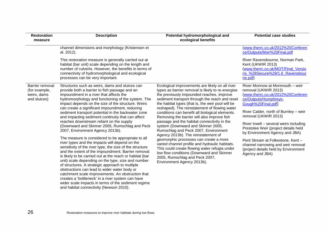
Barrier removal (for example, weirs, dams and sluices)
Structures such as weirs, dams and sluices can provide both a barrier to fish passage and an impoundment in a river that affects the hydromorphology and functioning of the system. The impact depends on the size of the structure. Weirs can create a significant impoundment, reducing sediment transport potential in the backwater zone and impacting sediment continuity that can affect reaches downstream reliant on the supply (Downward and Skinner 2005, Rumschlag and Peck 2007, Environment Agency 2013b).
The measure is considered to be appropriate to all river types and the impacts will depend on the sensitivity of the river type, the size of the structure and the extent of the impoundment. Barrier removal is likely to be carried out at the reach or habitat (bar unit) scale depending on the type, size and number of structures. A strategic approach to multiple obstructions can lead to wider water body or catchment scale improvements. An obstruction that creates a ‘bottleneck’ in a river system can have wider scale impacts in terms of the sediment regime and habitat connectivity (Newson 2010).
Ecological improvements are likely on all river types as barrier removal is likely to re-energise the previously impounded reaches, improve sediment transport through the reach and reset the habitat types (that is, the weir pool will be reshaped). The reinstatement of flowing water conditions can benefit all biological elements. Removing the barrier will also improve fish passage and the habitat connectivity in the system (Downward and Skinner 2005, Rumschlag and Peck 2007, Environment Agency 2013b). The reinstatement of geomorphic processes can create a more varied channel profile and hydraulic habitats. This could create flowing water refugia under low flow conditions (Downward and Skinner 2005, Rumschlag and Peck 2007, Environment Agency 2013b).
River Monnow at Monmouth – weir removal (UKWIR 2013) (www.therrc.co.uk/2012%20Conference/Outputs/Humphreys-
Gough%20Final.pdf)
River Calder, north of Burnley – weir removal (UKWIR 2013)
River Irwell – several weirs including Prestolee Weir (project details held by Environment Agency and JBA)
Pent Stream at Folkestone, Kent – channel narrowing and weir removal (project details held by Environment Agency and JBA)

Restoration measures to improve river habitats during low flows 27
Restoration measure
Description Potential hydromorphological and ecological benefits
Potential case studies
Barrier management (for example, weirs, dams, sluices)
Barrier management as opposed to removal means that the structure is operated to reduce some of the negative impacts. Since this does not include the full removal of the barrier, the benefits are likely to be less effective than full removal (Environment Agency 2013b).
The measure is considered to be appropriate to all river types. The impacts will depend on the sensitivity of the river type, the size of the structure and the scale of the impoundment.
Barrier management changes are likely to be made at the reach or habitat (bar unit) scale depending on the type, size and number of structures.
Barrier management may re-energise previously impounded reaches and improve sediment transport through the reach. Improved barrier management could also improve fish passage and the habitat connectivity in the system,(Environment Agency 2013b).
The reinstatement of geomorphic processes can create a more varied channel profile and hydraulic habitats. This could create flowing water refugia under low flow conditions (Environment Agency 2013b).
River Irwell, north-west England –several weirs (project details held by Environment Agency and JBA)
River Loddon, Arborfield, Berkshire (UKWIR 2013)
River Wensum, Norfolk (UKWIR 2013)
Berm creation (including planting of vegetation)
Fine sediment features such as berms are appropriate for lower energy systems where fine sediment is the dominant sediment type in the channel. They can take numerous forms, such as bars or lateral berms, and can be used to create diversity in lower energy systems. Planting of introduced features may also be carried out to provide cohesion and habitat variability. Locally sourced or imported sediment could be used to install the features; the type of fine sediment that is suitable would need to be determined from surrounding conditions (Florsheim and Mount 2002).
This measure is mostly applied at the reach or habitat (bar unit) scale. However, the trapping of fine sediment loads can have a wider scale impact if the feature encourages deposition of fine sediment above normal rates, particularly in terms of gravel features and habitat in downstream sections of the
The use of fine sediment to create features of hydromorphological diversity in slower flowing, fine sediment dominated rivers can narrow overwide channels. The interaction between depositing sediments and colonisation of plants can have a significant impact upon geomorphic processes and the creation of habitat diversity and flowing water refugia under low flow conditions (Florsheim and Mount 2002).
River Kennet, southern England, various locations – channel narrowing and berm creation (project details held by Environment Agency)

28 Restoration measures to improve river habitats during low flows
Restoration measure
Description Potential hydromorphological and ecological benefits
Potential case studies
river.
Large woody material (LWM) and flow deflectors
Large woody material (LWM) is added to a river channel with the aim of influencing local hydraulics to create diversity and alter patterns of erosion/scour and deposition. It works best when designed to mimic a habitat type that has been lost such as natural treefall (Gurnell et al. 2013).
Flow deflectors aim to increase the geomorphological processes and habitat variability locally. These features are mostly implemented at the reach or habitat (bar unit) scale (Abbe and Montgomery 1996, Jeffries et al. 2003, Stewart et al. 2006, Buchanan et al. 2012, Kristensen et al. 2013). They can be effective over a wider scale by trapping sediment and slowing flows, influencing the flow and sediment regime particularly for downstream reaches. They are most effective in lower energy river systems (see, for example: Brooks et al. 2006).
The interaction between depositing sediments and colonisation of plants can have a significant impact on geomorphic processes, and the creation of habitat diversity and flowing water refugia under low flows (Abbe and Montgomery 1996, Jeffries et al. 2003, Stewart et al. 2006, Buchanan et al. 2012, Kristensen et al. 2013, Gurnell et al. 2013).
The biological effectiveness of LWM/deflector placement for invertebrates and fish is still highly debated, with a range of different measures used in a range of river types (Roni et al. 2005, Stewart et al. 2006, Mott 2010).
River Bure, Bickling Hall Estate, Norfolk – tree felling (UKWIR 2013)
River Avon at Upper Woodford, Wiltshire – use of woody debris (UKWIR 2013)
River Trent at Croxall Lakes Nature Reserve, Staffordshire – channel widening and instream measures (LWM and islands) (www.therrc.co.uk/sites/default/files/projects/p880.pdf)
River Ribble at Settle, North Yorkshire – deflectors (project details held by Environment Agency and JBA)
Boulder clusters Boulder clusters are groups of large sediment sometimes found in higher energy river types which are only be mobilised in extreme flows. When reinstated, this is at the reach or habitat (bar unit) scale and is likely to have localised impacts on the diversity of flow and sediment patches (Stewart et al. 2006, Schiff et al. 2011, Müller et al. 2014).
In high energy systems, boulder clusters can be used to create habitat diversity by creating zones of fast flow either side of the boulder and a slack, slow flow area immediately downstream of the cluster. This can create flowing water refugia under low flow conditions (Stewart et al 2006, Schiff et al. 2011, Müller et al. 2014).
Long Preston Deeps on the River Ribble, North Yorkshire – boulder clusters introduced to the river (project details held by Environment Agency and JBA)
Inchewan Burn, near Perth, Scotland – RRC case study (www.therrc.co.uk/MOT/Final_Versions_%28Secure%29/5.9_Inchewan_Burn.pdf)
Reinstatement Rapids are high energy morphological features most often found in steep high energy river types. They are
In high energy systems, rapid reinstatement can be used to create habitat diversity by the
River Ogwen at Pont Pen-y-benglog, Gwynedd, Wales – rapid

Restoration measures to improve river habitats during low flows 29
Restoration measure
Description Potential hydromorphological and ecological benefits
Potential case studies
of rapids often composed of boulder and cobble sized material, with white water as a result of the relatively shallow flow across them. Rapids reinstatement by the placement of boulder and cobble material is generally implemented at the reach or habitat (bar unit) scale and is used to create localised diversity of flow and sediment patches.
creation of both fast flow zones and slack, slow flow areas. This can create flowing water refugia under low flow conditions.
reinstatement (UKWIR 2013) (www.therrc.co.uk/MOT/Final_Versions_%28Secure%29/5.3_Ogwen.pdf)
Figure 3.1 Summary of potential measures to improve river habitats during low flows
Gri
p b
lock
ing
Pla
nti
ng
na
tive
tre
es
Ma
na
gin
g f
ine
se
dim
en
t
Floo
dpla
in c
onne
ctiv
ity
Ass
iste
d n
atu
ral r
eco
very
Mov
ing
who
le p
lanf
orm
Re
-me
an
de
rin
g
Ban
k re
pro
fili
ng
Chan
nel
wid
en
ing
Chan
nel n
arro
win
g
Gra
vel
De
culv
ert
ing
Ba
rrie
r re
mo
val
Ba
rrie
r m
an
ag
em
en
t
Ber
ms
Flow
def
lect
ors
Bou
lder
Rap
ids
CatchmentScaleRiver type
Bedrock
Bar/Habitat
Step - pool
Plane bed
Wandering
Active single thread
Passive single thread
Lowland anatomosed

30 Restoration measures to improve river habitats during low flows
4 Case study assessments This section presents the main findings of the 5 case studies. The case studies selected for modelling met the following criteria:
single measure not combinations of measures
adjacent degraded sections or baseline data
available nearby record of discharge to inform hydraulic modelling
good quality LiDAR/aerial photography
The selected schemes are listed in Table 4.1. Appendix C contains additional information about the restoration schemes and additional habitat maps.
Table 4.1 Selected case studies
Restoration measure River type Study site Date of
implementation
1
Assisted natural recovery – restoration of lateral erosive processes following bank protection failure
Wandering River Wharfe, Upper Wharfedale
Gradual over many decades
2 Flood bank removal Wandering River Wharfe, Upper Wharfedale
Simulation
3 Weir removal Meandering River Irwell, Prestolee Weir
2013
4 Re-meandering Passive single tread
River Skerne, Darlington
1995 to 1998
5 Palaeochannel reconnection Active single thread
River Ribble, Long Preston Deeps SSSI
2011 to 2013
4.1 Assisted natural recovery in a wandering river
4.1.1 Background
The River Wharfe at Upper Wharfedale in north Yorkshire is one of England’s most active gravel bed rivers and is considered to be a wandering river under natural conditions.
Under naturalised/unconstrained conditions, the River Wharfe would exhibit large depositional bar features composed of cobbles and gravels. These features and the channel bed would be relatively free of fine sediment due to the high energy flow conditions preventing significant accumulation and deposition of sediment of this size. Lateral activity levels would generally be high, particularly at points where bars are deposited pushing flow towards one or both banks (often creating flow splitting). The high energy levels, and flow and sediment regime (that is, areas of erosion, deposition and both), alongside the predominantly gravel/cobble sediments, will result in a strong morphological and flow type diversity at a reach and local scale.

Restoration measures to improve river habitats during low flows 31
Two reaches were assessed for this project (Figure 4.1): a study reach of a recovering channel and a control reach.
Figure 4.1 Study reach locations for the River Wharfe
The study reach is located upstream of Starbotton (SD94507595). Here bank protection has failed gradually over many decades and reinstatement of the sediment regime, as a result of the failure of Buckden gravel trap (upstream), has historically starved downstream reaches of sediment resulting in incision. As a result of these failures, lateral erosive processes and deposition of gravel has occurred. The formally constrained channel has widened and significant gravel features have developed, resulting in a more varied channel form (Figure 4.2).
The study reach was compared with a control reach (SD94837501) of the same length where bank protection is still in place. As a result, the channel at the control reach is constrained and geomorphological processes restricted. The comparison with the study reach demonstrated hydromorphological and habitat changes from natural recovery when constraints to natural processes are removed.
Study reach – assisted natural recovery
Control reach
Flow
Scale: 500m
© Crown Copyright and database right 2014. Ordnance Survey licence number 100024198.

32 Restoration measures to improve river habitats during low flows
Figure 4.2 Gravel/cobble bar development at study reach
4.1.2 Hydraulic habitat modelling
The results of the assessment of the natural recovery under low flow conditions are shown in Figure 4.3. The control reach, the surrogate for pre-restoration conditions, was dominated by a slow flowing hydraulic biotope pool which accounted for 93% of the flow area in the channel. This indicates a lack of flowing water refugia at low flows, reflecting the constrained channel width resulting in a greater flow depth and uniform flow conditions. In the restored reach, in contrast, the dominance of the pool habitat was 50% of the channel and areas of faster flowing water were present, indicating faster flowing water refugia under low flow conditions. The differences reflect the development of gravel bars which has helped create a more diverse habitat composition and increased flow diversity adjacent to these zones of deposition. The increase in hydraulic habitat diversity also suggests increased resilience under low flow conditions.

Restoration measures to improve river habitats during low flows 33
Figure 4.3 Reach scale hydraulic habitat diversity under low flow conditions: River Wharfe – bank protection failure/assisted natural recovery
Study reach modelled under low flows (Q95) showing area of hydraulic biotopes
(%)
Control reach modelled under low flows (Q95) showing area of hydraulic biotopes
(%)
Pool
Glide
Run
Unbroken standing wave
Broken standing wave
Chute
The results of the assessment of the natural recovery at bankfull flow conditions are shown in Figure 4.4. The same discharge (between Q10 and Q20) was used for both assessments. The control reach was dominated by glide and riffle habitats with 1% of the channel containing pool conditions. The low occurrence of pool conditions reflects the confined nature of the channel and suggests only limited flow refugia at higher discharges.
Within the restored section the pool conditions were 4% greater, indicating a slight increase in refugia area, mostly at the edge of the channel reflecting the increased connectivity with the floodplain. The proportion of channel covered by glide conditions had decreased and the proportion of riffled flow and unbroken waves increased. This suggests that the velocities in the central channel had increased as a result of the increased morphological diversity and depositional features in the channel. This means that the presence of slow flowing refugia will be more important for ecological resilience during high flows.

34 Restoration measures to improve river habitats during low flows
Figure 4.4 Reach scale hydraulic habitat diversity under high flow conditions: River Wharfe– bank protection failure/assisted natural recovery
Study reach modelled under bankfull (Q10–Q20) flows showing area of
hydraulic biotopes (%)
Control reach modelled under bankfull (Q10–Q20) flows showing area of
hydraulic biotopes (%)
Pool
Glide
Run
Unbroken standing wave
Broken standing wave
Chute
4.1.3 Species-specific habitat assessments
In a high energy wandering system such as the Wharfe, the main fish species of interest are salmonid fish such as brown trout. Upland areas such as this are used by salmonids as spawning and rearing habitat. The availability of good quality gravel riffle habitat combined with relatively fast flowing water is ideal spawning habitat. The ‘young of the year’ salmonid fish generally occupy shallow areas of the river, with slower flow velocities than those needed to maintain spawning gravels. The deeper, slower flowing areas provide habitat for juvenile and adult salmonids (Environment Agency 2013b).
A review of the nearest Environment Agency fisheries monitoring site at Conistone Bridge (SD97916750) (National Fish Population Database, accessed January 2015) confirmed that there are populations of trout, bullhead, minnows and stone loach resident in the Wharfe. For the low flow scenario, habitat availability and quality was assessed for a range of brown trout life stages (0+, 1+ <20cm, >20cm and spawning).

Restoration measures to improve river habitats during low flows 35
Using the bankfull results, the availability of refugia habitat was assessed. JHab was used to assess THSI and HQI (see Section 2.2.2).
The results of the assessment of the provided natural recovery under low flow conditions are shown in Figure 4.5. The habitat provision for the various life stages of brown trout provided at the site where natural recovery had taken place showed a greater habitat quantity and quality than the control reach. The difference reflects the increase in geomorphological activity creating a more diverse habitat composition as shown by the assessment of hydraulic habitats.
A comparison of the distribution of the habitat provision for adult trout under low flow conditions was made by mapping the trout habitat suitability (Figure 4.6). Within the restored section, good quality adult and 1+ habitat can be observed at the apex of meander bends and in the upper reaches of the site. The upper section of the control reach contained poor habitat for adult, while there was some better habitat in the lower section. This demonstrates a potential increase in the patchiness and distribution of flowing water refugia under low flow conditions that can be exploited by adult brown trout.
Figure 4.5 Reach scale brown trout habitat suitability under low flow conditions: River Wharfe – bank protection failure/assisted natural recovery
Study reach 1: habitat quantity (THSI) Control reach: habitat quantity (THSI)
Study reach 1: habitat quality (HQI) Control reach: habitat quality (HQI)
3367
2575
3704
2179
0
500
1000
1500
2000
2500
3000
3500
4000
Adult (>20cm) 1+ (>0+ <20cm)
0+ Spawning
THSI
1561
693
2127
1192
0
500
1000
1500
2000
2500
3000
3500
4000
Adult (>20cm) 1+ (>0+ <20cm)
0+ Spawning
THSI
33
25
36
21
0
10
20
30
40
50
Adult (>20cm) 1+ (>0+ <20cm)
0+ Spawning
HQ
I
22
10
30
17
0
10
20
30
40
50
Adult (>20cm) 1+ (>0+ <20cm)
0+ Spawning
HQ
I
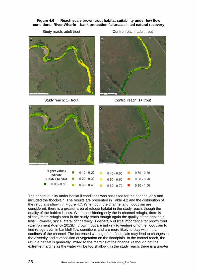
36 Restoration measures to improve river habitats during low flows
Figure 4.6 Reach scale brown trout habitat suitability under low flow conditions: River Wharfe – bank protection failure/assisted natural recovery
Study reach: adult trout Control reach: adult trout
Study reach: 1+ trout Control reach: 1+ trout
The habitat quality under bankfull conditions was assessed for the channel only and included the floodplain. The results are presented in Table 4.2 and the distribution of the refugia is shown in Figure 4.7. When both the channel and floodplain are considered, there is a greater area of refugia habitat in the study reach, though the quality of the habitat is less. When considering only the in-channel refugia, there is slightly more refugia area in the study reach though again the quality of the habitat is less. However, since lateral connectivity is generally of little importance for brown trout (Environment Agency 2013b), brown trout are unlikely to venture onto the floodplain to find refuge even in bankfull flow conditions and are more likely to stay within the confines of the channel. The increased wetting of the floodplain may lead to changes in the diversity and composition of vegetation on the floodplain. In the control reach, the refugia habitat is generally limited to the margins of the channel (although not the extreme margins as the water will be too shallow). In the study reach, there is a greater
Higher values indicate
suitable habitat

Restoration measures to improve river habitats during low flows 37
variety of good quality refugia to be found within the confines of the channel, especially on the outside of meander bends.
Table 4.2 Review of refugia available under bankfull conditions
Study reach 1 Control reach
THSI HQI THSI HQI
Refugia (including floodplain) 9097 38 5094 45
Refugia (channel only) 4911 40 4157 46
Figure 4.7 Reach scale brown trout habitat suitability refugia habitat at high flows: River Wharfe – bank protection failure/assisted natural recovery
Study reach 1: refugia Control reach: refugia
4.1.4 Summary of results
Reinstatement of natural processes as a result of bank protection failure (and sediment regime recovery linked to the failure of Buckden gravel trap) was considered as a ‘restoration measure’ for the River Wharfe just downstream of Buckden, where it exhibits incipient wandering characteristics.
Pre and post recovery hydraulic habitat variability, calculated during the modelling assessment, showed an improved hydraulic habitat diversity as a result of the natural recovery occurring, demonstrating the expected hydromorphological response to reinstatement of lateral erosive processes and growth of gravel/cobble morphological features in the channel. Slower pool/glides are part replaced by glides and riffles under low flow conditions, and glides are reduced and replaced by a series of pools. Riffled flow and unbroken standing waves and more in-channel refugia for brown trout are modelled under bankfull flow conditions. This would be the expected habitat and morphological diversity under unconstrained conditions for a wandering system. In the longer term, the ability of the channel to move laterally is expected to result in frequent channel switching and the development of further gravel/cobble bar features as the river migrates across the floodplain and increases sinuosity in places, as can be seen
Higher values indicate
suitable habitat
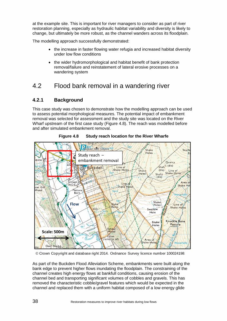
38 Restoration measures to improve river habitats during low flows
at the example site. This is important for river managers to consider as part of river restoration planning, especially as hydraulic habitat variability and diversity is likely to change, but ultimately be more robust, as the channel wanders across its floodplain.
The modelling approach successfully demonstrated:
the increase in faster flowing water refugia and increased habitat diversity under low flow conditions
the wider hydromorphological and habitat benefit of bank protection removal/failure and reinstatement of lateral erosive processes on a wandering system
4.2 Flood bank removal in a wandering river
4.2.1 Background
This case study was chosen to demonstrate how the modelling approach can be used to assess potential morphological measures. The potential impact of embankment removal was selected for assessment and the study site was located on the River Wharf upstream of the first case study (Figure 4.8). The reach was modelled before and after simulated embankment removal.
Figure 4.8 Study reach location for the River Wharfe
As part of the Buckden Flood Alleviation Scheme, embankments were built along the bank edge to prevent higher flows inundating the floodplain. The constraining of the channel creates high energy flows at bankfull conditions, causing erosion of the channel bed and transporting significant volumes of cobbles and gravels. This has removed the characteristic cobble/gravel features which would be expected in the channel and replaced them with a uniform habitat composed of a low energy glide
Study reach –embankment removal
Flow
Scale: 500m
© Crown Copyright and database right 2014. Ordnance Survey licence number 100024198.
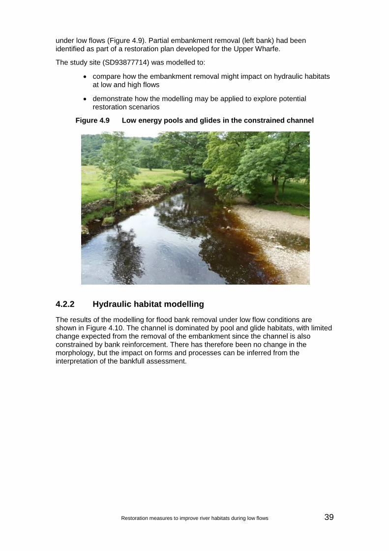
Restoration measures to improve river habitats during low flows 39
under low flows (Figure 4.9). Partial embankment removal (left bank) had been identified as part of a restoration plan developed for the Upper Wharfe.
The study site (SD93877714) was modelled to:
compare how the embankment removal might impact on hydraulic habitats at low and high flows
demonstrate how the modelling may be applied to explore potential restoration scenarios
Figure 4.9 Low energy pools and glides in the constrained channel
4.2.2 Hydraulic habitat modelling
The results of the modelling for flood bank removal under low flow conditions are shown in Figure 4.10. The channel is dominated by pool and glide habitats, with limited change expected from the removal of the embankment since the channel is also constrained by bank reinforcement. There has therefore been no change in the morphology, but the impact on forms and processes can be inferred from the interpretation of the bankfull assessment.

40 Restoration measures to improve river habitats during low flows
Figure 4.10 Reach scale hydraulic habitat diversity under low flow conditions: River Wharfe – embankment removal
Study reach before restoration modelled under low flows (Q95) showing area of
hydraulic biotopes (%)
Study reach after restoration modelled under low flows (Q95) showing area of
hydraulic biotopes (%)
Pool
Glide
Run
Unbroken standing wave
Broken standing wave
Chute
The results of the modelling of flood bank removal under high conditions (Q10–Q20) are shown in Figure 4.11. The same discharge was used for scenarios based on the volume of water it would take to reach bankfull before the embankment. The figures are for the in-channel areas and do not include flood plain areas. Both before and after removal of the embankment, the channel is dominated by unbroken standing waves and with some riffled flow. There was little change in the habitat composition of the channel from the removal of the embankment, meaning that the habitat composition would remain the same. This reflects the straightened and constrained nature of the
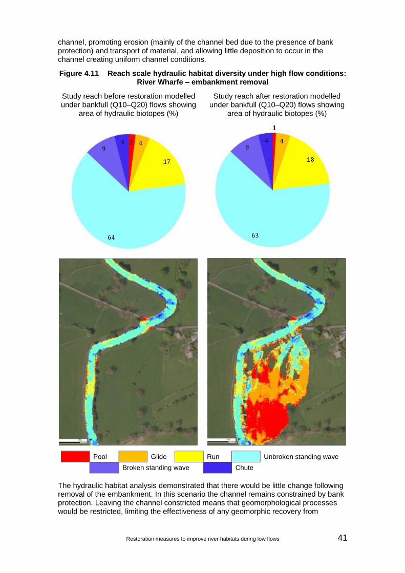
Restoration measures to improve river habitats during low flows 41
channel, promoting erosion (mainly of the channel bed due to the presence of bank protection) and transport of material, and allowing little deposition to occur in the channel creating uniform channel conditions.
Figure 4.11 Reach scale hydraulic habitat diversity under high flow conditions: River Wharfe – embankment removal
Study reach before restoration modelled under bankfull (Q10–Q20) flows showing
area of hydraulic biotopes (%)
Study reach after restoration modelled under bankfull (Q10–Q20) flows showing
area of hydraulic biotopes (%)
Pool
Glide
Run
Unbroken standing wave
Broken standing wave
Chute
The hydraulic habitat analysis demonstrated that there would be little change following removal of the embankment. In this scenario the channel remains constrained by bank protection. Leaving the channel constricted means that geomorphological processes would be restricted, limiting the effectiveness of any geomorphic recovery from

42 Restoration measures to improve river habitats during low flows
embankment removal. Additional measures would be needed to generate the expected hydromorphological and habitat diversity seen elsewhere on the River Wharfe.
This demonstrates the importance of considering the catchment context and local site restrictions to achieve project objectives rather than measures in isolation. Removing both the embankment and bank protection would be more likely to restore erosion and deposition processes, and to create in-channel features and a more varied channel form. If these measures were implemented, a change would be expected in the long term. However, the level of incision means that, even with removal of the embankment, the floodplain is still quite disconnected. Further works alongside the removal would improve the connectivity and show greater impact on hydraulic habitat and processes.
4.2.3 Species-specific habitat assessments
Like the first case study, the main species of interest in this section of the River Wharfe is brown trout. The results of the assessment of embankment removal under low flow conditions are shown in Figure 4.12. The habitat availability and quality for all life stages of brown trout at Q95 would remain unchanged following embankment removal. This is expected since changes in the hydraulic habitat composition were not seen under low flow conditions.
Figure 4.12 Reach scale brown trout habitat suitability under low flow conditions: River Wharfe – flood bank removal
Habitat quantity before restoration (THSI) Habitat quantity after restoration (THSI)
Habitat quality before restoration (HQI) Habitat quality after restoration (HQI)
1036919
1091
743
0
200
400
600
800
1000
1200
Adult (>20cm) 1+ (>0+ <20cm)
0+ Spawning
THSI
1036919
1091
743
0
200
400
600
800
1000
1200
Adult (>20cm) 1+ (>0+ <20cm)
0+ Spawning
THSI
1715
31
12
0
5
10
15
20
25
30
35
Adult (>20cm) 1+ (>0+ <20cm)
0+ Spawning
HQ
I
1715
31
12
0
5
10
15
20
25
30
35
Adult (>20cm) 1+ (>0+ <20cm)
0+ Spawning
HQ
I

Restoration measures to improve river habitats during low flows 43
The modelling suggests that the restoration measure was most effective under high flow conditions. There was an increase in predicted refugia habitat availability following embankment removal (Table 4.3), reflecting the large increase in floodplain inundations modelled with the removal of the embankment.
Table 4.3 Review of refugia available under bankfull conditions
Before restoration After restoration
THSI HQI THSI HQI
Refugia (including floodplain)
13278 36 4021 34
Refugia (channel only) 2767 32 2705 31
4.2.4 Summary of results
Improved floodplain connectivity proposed by flood embankment removal on the left bank of the River Wharfe immediately downstream of Buckden Bridge was modelled as a restoration measure to help reinstate the expected flow and sediment regime of this wandering system.
Pre and post embankment removal hydraulic habitat variability did not show significant positive responses as a result of removing the embankment. This is likely to be due to the bank protection remaining in place continuing to constrain the channel in the scenario and highlights the need for further in-channel measures to improve connectivity to the floodplain.
It is recommended that additional measures are considered for this site to aid the restoration of geomorphic processes. Further assessments should consider other site examples without channel constraints to better understand the impacts of embankment removal on channel morphology and processes. This demonstrates the importance of considering several restoration measures to achieve project objectives rather than measures in isolation, as this will ultimately improve the robustness of the system.
4.3 Weir removal in a wandering river
4.3.1 Background
The River Irwell is a meandering river with bedrock outcrops common in the bed and confined valley sides. Prestolee Mill Weir was located in Manchester (SD75040567) (Figure 4.13) where the watercourse is a confined, single thread channel displaying a pool–riffle–run–rapid morphology, particularly upstream of the impoundment zone of the weir. There is strong active gravel supply and transport in the reach. The bed is generally composed of gravels and cobbles, with some morphological differentiation forming point and lateral bar features. Steeper sections upstream of the influence of the weir displayed larger boulders, forming rapids.

44 Restoration measures to improve river habitats during low flows
Figure 4.13 Location of Prestolee Weir on the River Irwell
Prestolee Mill Weir (1.5–2.0m) was removed in July 2013 (Figure 4.14). Bedrock is evident throughout the reach local to the weir, both in the banks and on the channel bed, and the weir was founded on bedrock. The stored gravels upstream of the weir created a good quality bed and the sediments were mobile, with little evidence of consolidation and fine sediment infilling. As a result, at times of higher flow, sediment was still readily transported over the weir, with significant deposition occurring beyond the downstream face of the weir. Under unconstrained conditions, the River Irwell would be likely to exhibit a variable morphology with frequent gravel/cobble bars, regular transport of gravel and cobble sized material and smaller, high energy bedrock sections free from deposition. The bedrock presence provides a check on lateral and vertical erosion potential, and therefore significant planform change over time would not be expected. This is reflected in historic maps of the area.
The comparison between the pre and post removal modelled conditions demonstrates both the low flow and bankfull hydromorphological impact of the removed weir and how this influences hydraulic habitat variability, locally and up and downstream. The pre assessment is based on LiDAR data from 2009 and the post data on 2014 field assessments.
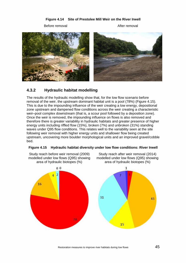
Restoration measures to improve river habitats during low flows 45
Figure 4.14 Site of Prestolee Mill Weir on the River Irwell
Before removal After removal
4.3.2 Hydraulic habitat modelling
The results of the hydraulic modelling show that, for the low flow scenario before removal of the weir, the upstream dominant habitat unit is a pool (78%) (Figure 4.15). This is due to the impounding influence of the weir creating a low energy, depositional zone upstream and dampened flow conditions across the weir creating a characteristic weir–pool complex downstream (that is, a scour pool followed by a deposition zone). Once the weir is removed, the impounding influence on flows is also removed and therefore there is greater variability in hydraulic habitats and greater presence of higher energy units including riffled flow (15%), broken (7%) and unbroken (31%) standing waves under Q95 flow conditions. This relates well to the variability seen at the site following weir removal with higher energy units and shallower flow being created upstream, uncovering more boulder morphological units and an improved gravel/cobble bed.
Figure 4.15 Hydraulic habitat diversity under low flow conditions: River Irwell
Study reach before weir removal (2009) modelled under low flows (Q95) showing
area of hydraulic biotopes (%)
Study reach after weir removal (2014) modelled under low flows (Q95) showing
area of hydraulic biotopes (%)

46 Restoration measures to improve river habitats during low flows
Pool
Glide
Run
Unbroken standing wave
Broken standing wave
Chute
The results of the bankfull flow assessment (Figure 4.16) show that the impounding influence of the weir is reduced. Local reaches with generally moderate gradients means that flow energy is high under these conditions, allowing transport of sediment over the weir and therefore showing hydraulic habitats dominated by unbroken standing waves (52%) and riffled flow (35%). For bankfull flows, the habitat variability is less distinct (a factor of the influence of the weir being significantly drowned out under higher flow conditions under existing conditions), with the most significant change being a reduction in riffled flow and an increase in unbroken standing waves close to the weir. There is a small reduction in overall wetted and habitat area for bankfull flow conditions as a result in a slightly reduced flow width upstream following weir removal.
Figure 4.16 Hydraulic habitat diversity under high flows: River Irwell
Study reach before weir removal (2009) modelled under bankfull (Q20–Q40)) flows
showing area of hydraulic biotopes (%)
Study reach after weir removal (2014) modelled under bankfull (Q20–Q40) flows
showing area of hydraulic biotopes (%)

Restoration measures to improve river habitats during low flows 47
Pool
Glide
Run
Unbroken standing wave
Broken standing wave
Chute
4.3.3 Species-specific habitat assessments
Assessment of the habitat quality was based on the fish species resident in the watercourse based on Environment Agency survey data from sites at Ringley (SD7632705307) located approximately 1.5km downstream of Prestolee Mill Weir and Radcliffe (SD7853006835) 5.8km upstream (National Fish Population Database, accessed November 2014.) The fish populations are dominated by large numbers of minnow (Phoxinus phoxinus). The presence of minnow and stone loach (Barbatula barbatula) indicate that the water quality of this stretch of the Irwell is good, as both species are sensitive to water pollution. A number of eurytopic generalist species were also sampled such as chub (Leuciscus cephalus) and gudgeon (Gobio gobio). These species have a preference for slow flowing rivers and lakes such as those which the impounded sections above weirs create. Small numbers of individuals of species which prefer higher velocities were found such as brown trout (Salmo trutta), dace (Leuciscus leuciscus) and roach (Rutilus rutilus).
A number of weirs have been removed from the Irwell system in recent years. This has improved the connectivity, allowing longitudinal migration and restoring the flowing water conditions preferred by rheophilic (preferring fast flow) species such as brown trout. Therefore the habitat analysis considered the impact of weir removal at Prestolee on both rheophilic fish (brown trout) and cyprinid fish preferring slower flows. For the low flow scenario, habitat availability and quality was assessed for a range of brown trout life stages (0+, 1+ <20cm, >20cm and spawning) and a single cyprinid life stage (0+), which is considered a primary control on the year class strength (see, for example: Mann 1995). Only one cyprinid life stage was investigated due to the limited information available and since adults tend be generalists found in a wide range of habitats. The bankfull results were used to assess the availability of refugia habitat.
The results of the assessment of the weir removal under low flow conditions are presented in Figures 4.17 and 4.18. The results show a decrease in both total habitat availability and quality for adult and 0+ brown trout following the removal of the weir. These life stages exhibit a preference for lower velocities and the change reflects the increased velocities following weir removal. Before the weir was removed, the 0+ brown trout habitat was predominantly located downstream of the weir, while the adult brown trout habitat was relatively evenly spread upstream and downstream of the weir. Following weir removal, there is very little 0+ brown trout habitat in the whole modelled reach, while the increased velocities led to an overall decrease in adult brown trout
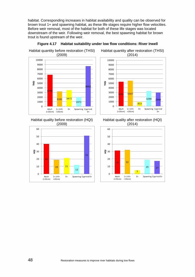
48 Restoration measures to improve river habitats during low flows
habitat. Corresponding increases in habitat availability and quality can be observed for brown trout 1+ and spawning habitat, as these life stages require higher flow velocities. Before weir removal, most of the habitat for both of these life stages was located downstream of the weir. Following weir removal, the best spawning habitat for brown trout is found upstream of the weir.
Figure 4.17 Habitat suitability under low flow conditions: River Irwell
Habitat quantity before restoration (THSI) (2009)
Habitat quantity after restoration (THSI) (2014)
Habitat quality before restoration (HQI) (2009)
Habitat quality after restoration (HQI) (2014)
6788
3181 3472
1971
8662
0
1000
2000
3000
4000
5000
6000
7000
8000
9000
10000
Adult (>20cm)
1+ (>0+ <20cm)
0+ Spawning Cyprinid 0+
THSI
5283 5507
853
3290 2940
0
1000
2000
3000
4000
5000
6000
7000
8000
9000
10000
Adult (>20cm)
1+ (>0+ <20cm)
0+ Spawning Cyprinid 0+
THSI
40
19 21
12
51
0
10
20
30
40
50
60
Adult (>20cm)
1+ (>0+ <20cm)
0+ Spawning Cyprinid 0+
HQ
I
31 32
5
19 17
0
10
20
30
40
50
60
Adult (>20cm)
1+ (>0+ <20cm)
0+ Spawning Cyprinid 0+
HQ
I

Restoration measures to improve river habitats during low flows 49
Figure 4.18 Reach scale brown trout habitat suitability under low flow conditions: River Irwell
Before (2009): 0+ brown trout After (2014): 0+ brown trout
Before (2009): brown trout spawning habitat
After (2014): brown trout spawning habitat
Figure 4.19 shows a substantial decrease in cyprinid 0+ habitat as expected for the returning flowing water conditions. Before weir removal, the best 0+ cyprinid habitat was found upstream of the weir in the impounded backwater. Following weir removal, the increased velocities in what used to be a backwater are less suitable for 0+ cyprinids, while the habitat downstream of the weir remains unsuitable.
Higher values indicate
suitable habitat

50 Restoration measures to improve river habitats during low flows
Figure 4.19 Reach scale brown trout habitat suitability under low flow conditions: River Irwell
Before (2009): 0+ cyprinid After (2014): 0+ cyprinid
The assessment of the channel under bankfull conditions (Table 4.4) shows a slight decrease in refugia habitat following weir removal. Due to the shape of the channel, the refugia habitat was located at the margins of the channel.
Table 4.4 Refugia availability under bankfull conditions
Before removal (2009) After removal (2014)
THSI HQI THSI HQI
All fish refugia 1708 8 1355 6
4.3.4 Summary of results
Removal of Prestolee Mill Weir on the River Irwell was modelled as an example of weir removal and impacts on hydromorphological and habitat diversity for an active single thread system.
The variability in the pre and post removal hydraulic habitat demonstrates the positive influence of the weir removal on hydromorphological processes characteristic of wandering river systems. The hydraulic habitat impact concurs with impacts seen at the site following removal in 2013, with an increase in higher energy units, particularly at lower flows. These units replace the lower energy pool units created upstream of the weir as a result of the impounding influence.
The quality of the cobble/gravel bed will improve as a result of reduced fine sediment infilling upstream of the weir and riffles, rapids and higher energy units will become more frequent. Continued diversity improvement are therefore expected as the channel evolves over time. This is the expected morphology and processes for an active single thread system such as the Irwell and is also what is seen in unconstrained reaches in other areas upstream of the Prestolee site. The removal of the weir is likely to affect longitudinal connectivity, which will impact on fish over a wider area than the study
Higher values indicate
suitable habitat

Restoration measures to improve river habitats during low flows 51
reach. This could result in wider catchment changes demonstrating how addressing localised modification bottlenecks can contribute to improvement across a catchment.
The modelling approach has successfully demonstrated the hydromorphological and habitat benefit of weir removal on this active single thread system at a reach scale. The presence of higher energy hydraulic habitat units under low flow conditions under post weir removal conditions, and the variability in shallow and deeper morphology as a result, provides a more robust habitat complex compared with the low energy, monotonous flow conditions created as a result of the influence of the weir pre removal.
However, the potential for reaction to removal can be high depending on the river type and local situation. This should always be assessed and interpreted by a geomorphologist/hydromorphologist and an ecologist.
4.4 Re-meandering of a passive single thread river
4.4.1 Background
The River Skerne at Darlington is a passive single thread river (low energy conditions) that has been modified in the historic past due to flood management practices and industrialisation. The open parkland it flows through is in a significantly urbanised area.
Approximately 2km of the formally straightened watercourse (NZ30111610) was restored in 1995 and 1998 (Figure 4.20) by the creation of 4 meanders (partial reconnection of a former channel route) and backwaters, and the reprofiling and protection of the river banks to prevent erosion (RRC 2014). Aerial images of the River Skerne pre and post restoration are shown in Figure 4.21.
The low energy characteristics of the passive River Skerne at Darlington mean that gravel features are rare and fine sediment dominates the channel bed. Lateral erosion is infrequent and higher flows have sufficient energy to only entrain fine sediment. Morphological variation in the channel, under naturalised conditions, is likely to involve development of fine sediment features that become vegetated and consolidated over time. The pre assessment was based on data collected in 1995 and post assessments on data from 2008.

52 Restoration measures to improve river habitats during low flows
Figure 4.20 Location of River Skerne study site
Figure 4.21 Aerial imagery of River Skerne at Darlington
Pre restoration, 1945 (image copyright Google Earth 2014)
© Crown Copyright and database right 2014. Ordnance Survey licence number 100024198.
Scale: 200m

Restoration measures to improve river habitats during low flows 53
Post restoration, 2008 (image copyright Google Earth 2014)
4.4.2 Hydraulic habitat modelling
The results of the assessment of the natural recovery under low flow conditions show that, under pre restored conditions, the dominant hydraulic habitat unit is pools, which account for 97% of the channel area (Figure 4.22). The re-meandering has increased the channel length, which would be expected to reduce channel energy levels rather than increase velocities. Post restoration pools still account for 97% of the flow area but the overall area of pools has increased from 439m2 to 989m2. This suggests that, in this situation, the re-meandering of the channel has not created higher energy flowing water refugia under low flow conditions.
Figure 4.22 Hydraulic habitat diversity under low flow conditions: River Skerne
Study reach before restoration modelled under low flows (Q95) showing area of
hydraulic biotopes (%)
Study reach after restoration modelled under low flows (Q95) showing area of
hydraulic biotopes (%)
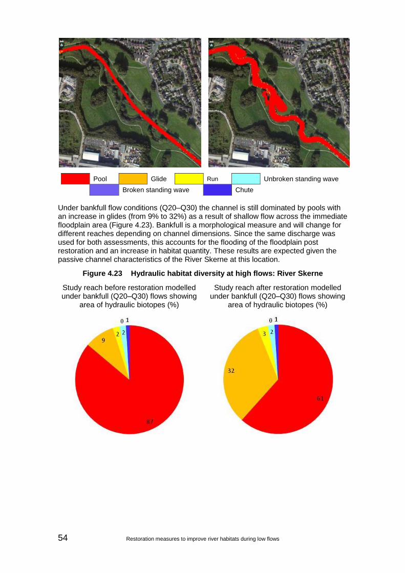
54 Restoration measures to improve river habitats during low flows
Pool
Glide
Run
Unbroken standing wave
Broken standing wave
Chute
Under bankfull flow conditions (Q20–Q30) the channel is still dominated by pools with an increase in glides (from 9% to 32%) as a result of shallow flow across the immediate floodplain area (Figure 4.23). Bankfull is a morphological measure and will change for different reaches depending on channel dimensions. Since the same discharge was used for both assessments, this accounts for the flooding of the floodplain post restoration and an increase in habitat quantity. These results are expected given the passive channel characteristics of the River Skerne at this location.
Figure 4.23 Hydraulic habitat diversity at high flows: River Skerne
Study reach before restoration modelled under bankfull (Q20–Q30) flows showing
area of hydraulic biotopes (%)
Study reach after restoration modelled under bankfull (Q20–Q30) flows showing
area of hydraulic biotopes (%)

Restoration measures to improve river habitats during low flows 55
Pool
Glide
Run
Unbroken standing wave
Broken standing wave
Chute
4.4.3 Species-specific habitat impact
There is limited availability of fish survey data for the Skerne at Darlington. The nearest Environment Agency fish survey site is Albert Road (NGR NZ2920015700), approximately 900m downstream, which was surveyed only once and a single chub captured. Therefore data from Weir Street (NGR NZ2920014800) 1.8km downstream and Haughton Road (NGR NZ3060015700) 0.5km upstream were reviewed upstream (National Fish Population Database, accessed November 2014.).
Although a small number of fish species and individuals have been collected during surveying on the Skerne, these fish cover a wide range of habitat preferences. These include brown trout (Salmo trutta) and dace (Leuciscus leuciscus), which are rheophilic and generally prefer faster flowing water, and perch (Perca fluviatilis) and chub (Leuciscus cephalus), which prefer slower flows. The habitat analysis considers the impact of restoration on both rheophilic fish (brown trout) and 0+ cyprinid fish found in slow flows.
The habitat availability shows that, for adult, 1+ and 0+ brown trout, the total habitat availability increased following restoration, while the overall quality of that habitat decreased (Figure 4.24). Following restoration, there is an increase in habitat variability, but the increase in habitat availability is driven by the increase in wetted area rather than the habitat improving; this is evidenced by the reduction in the habitat quality scores. As might be expected, both the quantity and quality of brown trout spawning habitat, which generally requires shallow fast flow, decreased following restoration.

56 Restoration measures to improve river habitats during low flows
Figure 4.24 Habitat suitability under low flow conditions: River Skerne
Habitat quantity before restoration (THSI) Habitat quantity after restoration (THSI)
Habitat quality before restoration (HQI) Habitat quality after restoration (HQI)
Following restoration there is a large increase in both the quantity and quality of 0+ cyprinid fish habitat. Before restoration, the 0+ cyprinid habitat was very uniform. Following restoration, pockets of high quality 0+ cyprinid habitat can be seen in the main channel and backwater areas (Figure 4.25). This is probably associated with a decrease in in-channel velocities associated with channel lengthening and the low velocities observed in the backwater areas.
810518
133 263545
0
500
1000
1500
2000
2500
Adult (>20cm)
1+ (>0+ <20cm)
0+ Spawning Cyprinid 0+
THSI
1334
652328 209
2404
0
500
1000
1500
2000
2500
Adult (>20cm)
1+ (>0+ <20cm)
0+ Spawning Cyprinid 0+
THSI
46
30
815
31
0
10
20
30
40
50
60
70
Adult (>20cm)
1+ (>0+ <20cm)
0+ Spawning Cyprinid 0+
HQ
I
34
178 5
60
0
10
20
30
40
50
60
70
Adult (>20cm)
1+ (>0+ <20cm)
0+ Spawning Cyprinid 0+
HQ
I

Restoration measures to improve river habitats during low flows 57
Figure 4.25 Reach scale brown trout habitat suitability under low flow conditions: River Skerne
Before: 0+ cyprinid After: 0+ cyprinid
Following restoration, there is also a large increase in the availability of refugia habitat at high flows (Table 4.5). The straightened nature of the channel before restoration led to uniform flows at high flow as well as at low flow (Figure 4.26). Following restoration, good refugia habitat was generated not only in the backwater areas (as may be expected) but also in the channel. The lower velocities in the channel may be a result of the increased length of the channel, but also of increased channel floodplain interactions from the reduction in in-channel velocities
Table 4.5 Refugia availability under bankfull conditions for the Skerne at Darlington
Before removal After removal
THSI HQI THSI HQI
Refugia (including floodplain) 1017 43 2750 42
Refugia (channel only) 1017 43 2135 52
Higher values indicate
suitable habitat

58 Restoration measures to improve river habitats during low flows
Figure 4.26 Refugia habitat under bankfull conditions: River Skerne
Before bankfull refugia After bankfull refugia
4.4.4 Summary of results
The re-meandering work on the River Skerne at Darlington is an example of a re-meandering restoration measure on a low energy, passive single thread river.
The pre and post re-meandering hydraulic habitat variability shows there is little impact on the diversity under Q95 flow conditions, with pools being the dominant biotope. This is similarly true for bankfull flow conditions where pools still dominate, but with an increase in glides as a result of local floodplain reconnection (the glides created in the floodplain with pools still dominate in the channel hydraulic habitat). These are expected outcomes given the low energy characteristics of the river under pre restored conditions and increasing the channel length through meandering is only likely to reduce energy levels further. This suggests that re-meandering and increasing channel length in low energy systems is unlikely to create higher energy flowing water flow refugia under low flow conditions or improved diversity, just an increase in overall wetted area. Most of the positive effects were seen at high flows by an increase in refugia.
Although the restoration work may not be considered to be functional from a hydromorphological perspective, the project has delivered other benefits in a constrained urban environment, such as backwaters and wetlands, improved public access and improved water quality through modification to outfalls (Aberg and Tapsell 2013). This demonstrates the importance of understanding the river type (forms and processes) when selecting suitable restoration measures to ensure they remain functional and sustainable in the short and long term.
Higher values indicate
suitable habitat
Restoration measures to improve river habitats during low flows 59
4.5 Palaeochannel reconnection in an active single thread river
4.5.1 Background
The River Ribble at the Long Preston Deeps Site of Special Scientific Interest (SSSI) (Figure 4.27) is an active single thread river characterised by an active gravel bed with some gravel bars in the northern half of the SSSI area, losing energy and becoming increasingly silty downstream (to the south of The Crook). These river characteristics conform with changes in local controls on channel form, with steeper gradients characterising the active/incipient wandering channel. These decline to the low gradients characterising the single thread channel as it flows across old lake sediments.
Pressures at the site that are constraining the natural wandering characteristics of the river include:
increased channel capacity during floods – flood embankments
a modified channel – through past straightening and river training (that is, bank protection)
a heavily managed floodplain – there is significant livestock access to the channel
Part of the SSSI was restored in 2011 to 2012 as part of a wider restoration and naturalisation plan for the River Ribble and Long Preston Deeps SSSI. This included flood embankment realignment, bank protection removal, chute channel creation and palaeochannel reconnection.
This study focused on the impacts of restoring/reconnecting the palaeochannel (SD80966091) (Figure 4.28). The palaeochannel is connected at medium–high flow conditions, but the existing channel is the main channel and takes the majority of the flow. The pre assessment was based on data collected in 2004 and post assessments on data from 2014.
Under naturalised/unconstrained conditions, the channel is likely to exhibit depositional features composed of gravels and some cobbles, with relatively little fine sediment infilling of these features as a result of the moderately energetic flow conditions associated with a river of this type. Bank erosion and planform change would be moderate and the hydromorphological diversity high with varied hydraulic habitat units created by the riffle–run–pool morphology common to this river type.

60 Restoration measures to improve river habitats during low flows
Figure 4.27 Location of River Ribble study site
Figure 4.28 Aerial imagery of the River Ribble study site
4.5.2 Hydraulic habitat modelling
Assessment of the channel before and after restoration shows that, under low flow conditions, there is no change to the hydraulic habitat diversity in the channel

Restoration measures to improve river habitats during low flows 61
(Figure 4.29). This is to be expected as the palaeochannel only reconnects during higher flows.
Figure 4.29 Hydraulic habitat diversity under low flow conditions: River Ribble
Study reach before restoration modelled under low flows (Q95) showing area of
hydraulic biotopes (%)
Study reach after restoration modelled under low flows (Q95) showing area of
hydraulic biotopes (%)
Pool
Glide
Run
Unbroken standing wave
Broken standing wave
Chute
Under bankfull flows, the palaeochannel is connected under both pre and post reconnection scenarios (Figure 4.30). This is because water did enter the palaeo feature from the downstream end and filled as water levels rose in the main channel before the reconnection at the upstream end. The hydraulic habitats are moderately impacted as a result of the reconnection, with a reduction in pool units (from 46% to 36%) mainly in the palaeochannel being reconnected. These are replaced mainly by glides and some small areas of riffle at the upstream reconnection point.

62 Restoration measures to improve river habitats during low flows
Figure 4.30 Hydraulic habitat diversity under high flows: River Ribble
Study reach modelled under bankfull (Q10–Q30) flows showing area of
hydraulic biotopes (%)
Control reach modelled under bankfull (Q10–Q30) flows showing area of
hydraulic biotopes (%)
Pool
Glide
Run
Unbroken standing wave
Broken standing wave
Chute
There has been little change in the diversity in the current main channel since the restoration measure was implemented. However, this is likely to change over time as the palaeo feature reacts to the increased frequency and energy of flows. An indication that change can be expected is shown by the subtlety different patterns in shear stress outputs from the hydraulic model (Figure 4.31). This demonstrates that the measure will change the patterns of substrate erosion and deposition over time.

Restoration measures to improve river habitats during low flows 63
Figure 4.31 Shear stress variability under high flows: River Ribble
Study reach modelled under bankfull flows showing shear stress variability
Control reach modelled under bankfull flows showing shear stress variability
4.5.3 Species-specific habitat impact
Fisheries data were obtained from the Environment Agency monitoring site adjacent to the study site at Hollins Hall Barn (SD8078061079) and Arnford, approximately 9km downstream (SD83335629). The survey results show that the community is dominated by the rheophilic species, Atlantic salmon (Salmo salar), and to a lesser extent by brown trout (Salmo trutta); some eels are present. Based on available information, habitat analysis considered a range of brown trout life stages (0+, 1+ <20cm, >20cm and spawning) and refugia under bankfull conditions. The results for the low flow conditions show no change to instream habitat (Figure 4.32). This may be expected since the palaeochannels only connect at higher flows and there has not been significant channel adjustment since the scheme was implemented.
Figure 4.32 Habitat suitability under low flow conditions: River Ribble
Habitat quantity before restoration (THSI) Habitat quantity after restoration (THSI)
1036919
1091
743
0
250
500
750
1000
1250
1500
Adult (>20cm) 1+ (>0+ <20cm)
0+ Spawning
THSI
1036919
1091
743
0
250
500
750
1000
1250
1500
Adult (>20cm) 1+ (>0+ <20cm)
0+ Spawning
THSI

64 Restoration measures to improve river habitats during low flows
Habitat quality before restoration (HQI) Habitat quality after restoration (HQI)
Assessment of the conditions at high flows shows a small increase in refugia habitat but no change in the quality of the habitat (Table 4.6).
Table 4.6 Refugia availability under bankfull conditions for the Ribble
Pre reconnection Post reconnection
THSI HQI THSI HQI
Refugia (channel only) 11074 36 11352 37
4.5.4 Summary of results
The palaeochannel reconnection on the River Ribble at Long Preston Deeps SSSI provides an example of this restoration measure on an active single thread river type with some incipient wandering characteristics.
Assessment of the scheme showed no observable change in habitat under low flow conditions. There was a small increase in refugia habitat at bankfull conditions, associated with the increase in wetted area which followed reconnection of the palaeochannel. Therefore, the model outputs suggest there is only likely to be a relatively local and moderate response to the palaeochannel reconnection at this location. The results suggest that this measure applied in isolation is not effective at creating flowing water refugia under low flow conditions. Over time it is expected that there will be some channel adjustment during bankfull conditions, which may change the instream habitat conditions. The timescale of change will depend on the frequency of bankfull events and the power of the stream.
This restoration scheme was carried out as part of a suite of other restoration measures locally (including improved floodplain reconnection and riparian zone planting) which, in combination, are likely to influence in channel processes to a greater extent than the reconnection of the small palaeochannel considered here. Other palaeochannels in the area have been identified for reconnection as part of a wider plan that will increase the influence on channel processes in the long term and which is expected to improve in-channel habitat diversity.
1715
31
12
0
5
10
15
20
25
30
35
Adult (>20cm) 1+ (>0+ <20cm)
0+ Spawning
HQ
I
1715
31
12
0
5
10
15
20
25
30
35
Adult (>20cm) 1+ (>0+ <20cm)
0+ Spawning
HQ
I
Restoration measures to improve river habitats during low flows 65
4.6 Discussion
The results from the assessments of the morphological measures and the modelling approach are discussed separately below.
4.6.1 Morphology measures
Assisted natural recovery/cessation of management was successful in restoring natural hydromorphological processes in a wandering river through the reinstatement of lateral erosive processes and growth of gravel/cobble morphological features in the channel. Slower pool and glides were partly replaced by glides and riffles under low flow conditions. The increase in channel biotope diversity created an increase in the presence of faster flowing water refugia and increased habitat diversity under low flow conditions. This demonstrated that assisted natural recovery is a suitable measure to increase ecological resilience in wandering rivers.
Modelling of the impact of flood embankment removal to increase floodplain connectivity in a wandering river did not show any change in habitat provision under low flow conditions. This was likely to be a consequence of the bank protection that remained in place continuing to constrain the channel and emphasises the importance of restoring geomorphic processes in any restoration measure.
Weir removal in an active single thread system restored hydromorphological processes and increased the presence of faster flowing biotopes and habitat diversity under low flow conditions. Over time it is anticipated that the quality of the cobble/gravel bed will improve as a result of reduced fine sediment infilling upstream of the weir and riffles; rapids and higher energy units will become more frequent and continued diversity improvement as the channel evolves over time will therefore be seen. The removal of the weir is likely to affect longitudinal connectivity, which will impact on fish over a wider area than the study reach. This could result in wider catchment changes, demonstrating how addressing localised modification ‘bottle-necks’ can contribute to improvement across a catchment.
The re-meandering of a low energy, passive single thread river showed little impact on habitat diversity and flowing water refugia under low flow conditions, with pools remaining the dominant biotope. These results are expected outcomes since the river had low energy characteristics before restoration and increasing the channel length through meandering reduced energy levels further. This suggests that re-meandering and increasing channel length in low energy systems is unlikely to create higher energy flowing water flow refugia under low flow conditions or improved diversity; it will just increase the overall wetted area.
The palaeochannel reconnection in an active single thread river type showed no observable change in habitat under low flow conditions. This result suggests that this measure applied in isolation is not yet effective at creating flowing water refugia under low flow conditions. Over time it is expected that there will be some channel adjustment during bankfull conditions which may change the instream habitat conditions. The timescale of change will depend on the frequency of bankfull events and the power of the stream.
The assessment of the 5 case studies demonstrates the importance of:
understanding the river type (forms and processes) when selecting suitable restoration measures to improve habitat conditions under low flows
ensuring the restored watercourses remain functional and sustainable in the short and long term

66 Restoration measures to improve river habitats during low flows
Restoring hydromorphological processes is crucial in increasing the sustainability of schemes and greatly influences the rate of channel response and so timescales of recovery. Timescales of physical change may take many decades and ecological response even longer (Gilvear et al. 2013).
4.6.2 Modelling approach
The data collection and modelling process used in this study has identified some considerations which need to be taken into account when selecting potential watercourses or restoration schemes for assessment.
For example, the aerial imagery/photography analysis approach to determining water depths in deeper areas depends strongly on the availability, quality, resolution, amount of tree cover and timing of the aerial imagery. It should also be checked for sensibility by a geomorphological or local expert against other survey information. Where suitable aerial imagery/photography are available, these may provide sufficient information for the modelling process to enable conclusions to be drawn on the impact of restoration measures on hydraulic habitat variability. This approach has been reviewed and tested in previous studies (see, for example: Bradbrook 2006, JBA Consulting 2013, Sear et al. 2013).
The approach based on modelling and software provides the ability to model large sections of river cost effectively and at a high resolution. This could provide a useful screening tool which can be applied at catchment or river scale to identify breaks in river form and processes under different flow regimes, enabling more expensive field surveys to focus on validating the conclusions.
The impacts of restoration measures need to be considered over both space and time (short, medium and long term) to determine the functionality and sustainability of the approach. Repeated assessments could improve our understanding of the timescale of change and influence when schemes are revisited to carry out post project appraisal. Monitoring the ecological change associated with the schemes would enable a better understanding of the ecological response to the hydromorphological change.
To improve the robustness of the approach it is recommended that:
the technique is applied to more schemes utilising different restoration measures
the results are validated with field assessments
Comparing the results of the hydraulic models with field assessments of hydraulic maps such as those produced using an acoustic Doppler current profiler (see, for example: Wallis et al. 2012) or field biotope mapping would validate the modelling approach.

Restoration measures to improve river habitats during low flows 67
5 Guide to selecting restoration measures
This section presents a matrix (Table 5.1) to help target restoration measures to locations where the most likely benefits can be realised and which will lead to increased ecological resilience to extreme flows. The findings of the review of available restoration measures and the locations where they are most likely to be effective are presented in Table 3.1, Figure 3.1 and Appendix D.
To demonstrate how the results from this project and other assessments could be built into a guide, the matrix was designed to show how restoration measures could deliver improvements to river channel habitats during low flow conditions. Consideration of the presence of high flow refugia was included for completeness. This is important since the measures must be robust and sustainable, and perform across the expected range of flows in any given river type.
It was beyond the scope of the project to carry out a full systematic evidence review of all available sources. However, even the limited assessment made as part of the measures review and case study selection highlighted limitations that prevent confident conclusions from being drawn. Examples are these limitations are given below.
While some measures are well documented (others less so), a general lack of information in published studies about the river type where the measure was applied makes it difficult to conduct a meta-analysis of a range of studies to assess wider applicability.
Most published research is limited to a few specific rivers types, with a lack of monitoring and assessments for bedrock, step-pool, wandering, plane bed and lowland anastomosing rivers.
Most reported studies were at a reach scale with few schemes at a water body or catchment scale.
Examples of restoration/rehabilitation measures often lack the monitoring data needed to justify confident assessments to inform the matrix.
Timescales of recovery may well be longer than the period of time allocated for monitoring, or recovery may be too slow to yet be detected.
Where measures have been monitored and assessed, few studies report on how the measure performs or affects the channel at high flows.
Despite these limitations it was possible to produce a guide (Table 5.1) which has the potential to be extended as more information emerges. In addition, a more comprehensive literature review might help to refine the confidence assessments.
5.1 About the matrix
The matrix provides a ‘traffic light’ system for determining the level to which each morphological measure is likely to improve ecological resilience. Measures identified as ‘green’ are likely to be the most appropriate to the river type and to have the greatest positive impact on improving the low flow environment. ‘Yellow’ implies a moderate impact and ‘red’ those considered to have a low impact – though they may, in some circumstances, still be appropriate for the river type. The matrix also highlights those measures that are not appropriate for the particular river type as they are considered

68 Restoration measures to improve river habitats during low flows
not to work with the natural geomorphic processes associated with that particular river type and are unlikely to be sustainable.
Grey shaded areas indicate measures regarded as unsustainable. They are considered not to work effectively with the natural geomorphic processes associated with the particular river type, and so are unlikely to be sustainable and are therefore inappropriate.
The colour coding is based on expert opinion – JBA staff, the project board and the literature review as part of the measures selection process (see Table 3.1).
In addition to the colour coding, the matrix also indicates the degree of anticipated benefits:
‘H’ indicates 2 or more case studies with measured benefits
‘M’ indicates that the literature reviewed shows some measured benefit
‘L’ indicates that the published/grey literature reviewed shows the measure may provide some benefits but lacks conclusive monitoring data or evidence is contradictory
The numbers beneath the letters ‘H’, ‘M’ and ‘L’ in Table 5.1 indicate the source from the literature review on which the indicated assessment is based. These sources are listed in Table 5.2 and analysed in Appendix D.
Table 5.2 Key to sources cited in the matrix (Table 5.1)
Ref. no Source Ref. no Source
1 Abbe and Montgomery 1996 26 JBA 2012-14b*
2 Archer and Newson 2002 27 JBA 2014a*
3 Besacier-Monbertrand et al. 2012 28 JBA 2014b*
4 Buchanan et al. 2012 29 JBA 2014c*
5 Buijse et al. 2002 30 Kennedy et al. 2014
6 Clilverd et al. 2013 31 Kondolf 2006
7 Davidson and Eaton 2013 32 Kristensen et al. 2011
8 Downs and Thorne 2000 33 Kristensen et al. 2013
9 Downward and Skinner 2005 34 Kristensen et al. 2014
10 Endreny and Soulman 2011 35 Large and Petts 1996
11 Environment Agency 2005* 36 Luderitz et al. 2011
12 Feld et al. 2011 37 Müller et al. 2014
13 Florsheim and Mount 2002 38 Newson 2002
14 Gumiero et al. 2013 39 Pander et al. 2015
15 Hammersmark et al. 2008 40 Pedersen et al. 2007
16 Harper et al. 1998 41 Pedersen et al. 2009
17 Holden 2009 42 Pulg et al. 2013
18 Jeffries et al. 2003 43 RRC 1999
19 JBA 2011* 44 Ribble Rivers Trust 2012
20 JBA 2012a* 45 Rohde et al. 2005
21 JBA 2012b* 46 Schirmer et al. 2014
22 JBA 2012c* 47 Schwartz et al. 2014
23 JBA 2012d* 48 Sear and Newson 2004
24 JBA 2012-13* 49 Sear et al. 2010
25 JBA 2012-14a* 50 Van Zyll De Jong et al. 1997
Notes: See References for details of these sources. * Unpublished

Assessing the Appropriateness of Low Flow Restoration Measures 69
Table 5.1 Guide of application of measures to improve low flow conditions
RIVER TYPE Grip blockingPlanting native
trees
Fine sediment
measures
Floodplain
connectivity
Assisted
natural
recovery
Moving whole
planform
Re-meandering,
palaeo channel /
oxbow
reconnection
Bank
reprofiling
Channel
widening
Channel
narrowing
Gravel addition /
bed reprofilingDeculverting
Barrier
removal
Barrier
managementBerm creation
LWM and flow
deflectors
Boulder
clusters
Reinstatement
of rapids
Bedrock Likely to be found in upland areas; fish species of interest – salmonids, probably brown trout
L L L2 38 9
L L L2 38 9
L L L2 38 9
Step-pool Likely to be found in upland areas; fish species of interest – salmonids, probably brown trout, bullheads.
L L L L2 38 9 10
L L L L2 38 9 10
L L L L2 38 9 10
Plane-bed Likely to contain salmonids (including brown trout, and possibly salmon), also coarse fish such as grayling, chub and dace
L L38 9
L L38 9
L L38 9
Wandering
L M L L L L L L14, 20 27, 38 36 29 45 15 9 4
L L L L L L L14, 20 27, 38 36 20 45 15 9
H M L L L L L L14, 15, 20, 27 27, 38 36 20 45 15 9 4
Active single thread Likely to contain a wide range of salmonid and coarse fish – including grayling, barbel and roach, and in very lowland reaches, bream and carp
L M L L L L M L M L L L M L17, 44 25, 49 12 14, 35 38 43 24, 32, 36 8 19, 45 12, 32, 37, 41, 48 9 12 1, 16, 26, 49, 50 37, 50
L M L L L L M L L L L L L L17, 44 25, 50 12 14, 35 38 43 24, 32, 36 8 19, 45 12, 32, 37, 41, 48 9 12 1, 49, 50 37, 50
L M L H L L M L M L L L H L17, 44 25, 49 12 5, 14, 35 38 43 24, 32, 36 8 19, 45 12, 32, 37, 41, 48 9 12 1, 8, 16, 26, 49, 50 37, 50
Passive single thread Likely to contain a wide range of salmonid and coarse fish – including grayling, barbel and roach, and in very lowland reaches, bream and carp
L L L L L L H M L L M L12 14 38 34, 40 28, 32 22 12, 16, 32, 37, 41, 42,
47
9, 21, 22 12 21 23, 26, 30 37
L L L L L L H M L L L L12 14 38 40 28, 32 22 12, 16, 32, 37, 41, 42,
47
9, 21, 22 12 21 30 37
L M L L L L H M L L M L12 14, 6 38 34, 40 28, 32 22 12, 16, 32, 37, 41, 42,
47
9, 21, 22 12 21 23, 26, 30 37
Lowland anastomosed Likely to contain a wide range of salmonid and coarse fish – including grayling, barbel and roach, and in very lowland reaches, bream and carp
M L L L L L L M25, 49 13, 14 38 31, 39 9, 45 41 9 16, 26, 49
M L L L L L L L25, 50 13, 14 38 31, 39 9, 45 41 9 49
M H L L L L L M25, 49 3, 5, 13, 14 38 31, 39 9, 45 41 9 16, 26, 49
See the text for an explanation of the significance of 'H', 'M' and
'L', and Table 5.2 for details of the numbered sources.
Low possibility of either enhancing riparian habitat, leading to a more
heterogeneous channel bed morphology or creating a range of refugia for freshwater
organisms during low flows
Inappropriate restoration measure for the river type
High possibility of either enhancing riparian habitat, leading to a more
heterogeneous channel bed morphology or creating a range of refugia for
freshwater organisms during low flows
Moderate possibility of either enhancing riparian habitat, leading to a more
heterogeneous channel bed morphology or creating a range of refugia for
freshwater organisms during low flows
Bankfull flow
hydromorphic impact
Low flow hydromorphic
impact
Low flow ecology impact
Bankfull flow
hydromorphic impact
Low flow hydromorphic
impact
Low flow ecology impact
Bankfull flow
hydromorphic impact
Low flow hydromorphic
impact
Low flow ecology impact
Bankfull flow
hydromorphic impact
Low flow hydromorphic
impact
Low flow ecology impact
Low flow hydromorphic
impact
Low flow ecology impact
Bankfull flow
hydromorphic impact
Low flow hydromorphic
impact
Low flow ecology impact
Bankfull flow
hydromorphic impact
Low flow hydromorphic
impact
Low flow ecology impact
Bankfull flow
hydromorphic impact
70 Restoration measures to improve river habitats during low flows
5.2 Discussion
The matrix captures expert opinion and available evidence to identify and target which measures are most likely to improve habitat quality and provide refugia for freshwater organisms during low flows. It highlights the needs for assessments to specifically review how the measures perform under low flow conditions. In its current format the matrix should not be applied in isolation but considered within the local context.
Less interventionist measures such as catchment management, fine sediment control and riparian measures (for example, fencing and tree planting) can be carried out with low risk. These measures cause less direct disruption to the stream channels, can be applied to all river types and have wider multiple benefits. However, measures which include significant channel works, such as moving the planform, should be considered in the wider context of catchment processes and in consultation with an expert geomorphologist. This will ensure that they are aligned to both local and catchment system dynamics and adopt a catchment-based approach to river management.
Often, 2 or more restoration measures may be applied at the same time to ensure physical river processes are restored. For the purposes of the matrix, each measure was considered in isolation to highlight those measures which could be implemented to target the low flow environment. Without wider considerations, single measures may be either ineffective or have unintended consequences (Brown and Pasternack 2008, Feld et al. 2011, Salant et al. 2012). Further studies could consider combinations of measures and assessments of schemes over different timescales to provide information about how channels adjust over time and vary with different river types and flow regimes.
Most restoration across England has occurred on a limited range of river types. This limits the data available for interpreting physical process change and biological response across a range of river types. However, as this project has demonstrated, concepts can be simulated using modelling to project how channels might change and what benefits might be realised.
To improve the usefulness and confidence in the matrix, it will need to be updated, revised and tested. However, the river types used may not be easily understood by matrix users because the modified version of the Montgomery and Buffington (1997) river classification can be hard to apply to systems or watercourses with a high degree of modification. If wrongly applied, the matrix could lead to the implementation of inappropriate measures (Boavida et al. 2012). A new river typology with 22 river types, which is consistent with WFD’s high-level typology and categorises channel type based on current condition, sensitivity and trajectories of change has been developed and may offer a more practical and easy-to-understand approach (Gurnell et al. 2015). This would require further assessment and testing.
A better understanding of how aquatic plants and animals respond to the change in physical processes and how this is influenced by factors such as recolonisation processes (for example, sources of colonists) and interaction with other pressures would help to improve confidence in some measures.
Monitoring of impacts could be targeted to measures/river types to help address specific gaps in knowledge. Some critical gaps are in the area of assessments of catchment scale measures and the application of measures in higher energy systems. A standardised approach to monitoring integrating hydromorphological and biological elements based on a sound scientific approach could usefully be developed and encouraged. This could build on existing approaches such as ‘Practical river restoration appraisal guidance for monitoring options’ (RRC 2011). This provides a structured approach to assist practitioners in the process of setting objectives and monitoring

Restoration measures to improve river habitats during low flows 71
protocols as part of a river restoration project. It is hoped that such studies will help inform this understanding and improve certainty.
72 Restoration measures to improve river habitats during low flows
6 Conclusions Restoration of many river systems, at various scales, will be required to meet good ecological status objectives. Improving the condition of rivers will also increase their resilience to pressures created as the climate changes, such as the changing frequency and magnitude of low and high flow events.
There is a lack of evidence on the effectiveness of morphological measures under low flow conditions. This is affecting confidence in selecting the most cost-effective and sustainable measures.
This study used an approach based on hydraulic modelling to assess the changes in large sections of river in a cost-effective way and at a high resolution. This allowed new evidence to be generated for a small selection of measures.
Modelling results demonstrate the success of assisted natural recovery and weir removal in improving low flow conditions. Embankment removal and paleo channel reconnection had limited benefit under low flow conditions in the short term; however, they had benefits at high flows and can be expected to evolve over time so that further benefits may be realised. Re-meandering of low energy passive rivers did not lead to any improvement in low flow conditions.
To help guide practitioners and to ensure that the right restoration measures are applied in the right place to have a positive impact and be sustainable in the long term, a matrix was developed to indicate the range of measures and channel types likely to be encountered in English rivers. The matrix is based on expert judgement and a partial literature review. The review helped to assign confidence statements to the various measures and to indicate evidence gaps.
This structured approach will help support better decision making around the targeting of in-channel measures. However, more work is needed to ensure both a wider uptake of measures and cost-effective river channel management.
A more straightforward river typology would make the matrix easier to use. A more extensive literature review may help to refine some of the confidence statements and, in particular, the application of measures in combination. This could be developed as a guide for informing the suitability of measures in improving low flow conditions.
In the medium to long term, it will be important to ensure that a sound scientific approach to effective monitoring of other measures is adopted to address evidence gaps and to reduce uncertainty about how useful different measures may be, particularly in higher energy rivers, over longer timescales and at larger spatial scales.
A good way to extend the evidence base and improve the matrix is by working in partnership with other organisations that are currently implementing morphological measures.
Restoration measures to improve river habitats during low flows 73
References ABBE, T.B. AND MONTGOMERY, D.R., 1996. Large woody debris jams, channel hydraulics and habitat formation in large rivers. Regulated Rivers: Research and Management, 12 (2-3), 201-221.
ABERG, E.U. AND TAPSELL, S. 2013. Revisiting the River Skerne: the long-term social benefits or river rehabilitation. Landscape and Urban Planning, 113, 94-103.
ADRIAENSSENS, V., DE BAETS, B. GOETHALS, P. AND DE PAUW, N. 2004. Fuzzy-rule based models for decision support in ecosystem management. Science of the Total Environment, 319 (1-3), 1-12.
ALLAN, J.D., 2004. Landscape and riverscapes: the influence of land use on stream ecosystems. Annual Review of Ecology Evolution and Systematics, 35, 257-284.
ANDERSON, R. 2010. Restoring afforested peat bogs: results of current research. Forestry Commission Forest Research Information Notes. Forestry Commission, Edinburgh.
ARCHER, D. AND NEWSON, M., 2002. The use of indices of flow variability in assessing the hydrological and instream habitat impacts of upland afforestation and drainage. Journal of Hydrology, 268 (1-4), 244-258.
ARMSTRONG, J.D., KEMP, P.S., KENNEDY, G.J.A., LADLE, M. AND MILNER, A.J. 2003. Habitat requirements of Atlantic salmon and brown trout in rivers and streams. Fisheries Research, 62 (2), 143-170.
ATKINSON, C.L., JULIAN, J.P. AND VAUGHN, C.C., 2014 Species and function lost: Role of drought in structuring stream communities. Biological Conservation. 176, 30-38
BELLAMY, P.E., STEPHEN, L., MACLEAN, I.S. AND GRANT, M.C., 2012. Response of blanket bog vegetation to drain-blocking. Applied Vegetation Science, 15 (1), 129-135.
BESACIER-MONBERTRAND, A.-L., PAILLEX, A., AND CASTELLA, 2012. Short-term impacts of lateral hydrological connectivity restoration on aquatic macroinvertebrates. River Restoration and Applications, 30 (5), 557-570.
BIGGS, J., CORFIELD, A., GRØN, P., HANSEN, H.O., WALKTER, D., WHITFIELD, M. AND WILLIAMS, P., 1998. Restoration of the rivers Brede, Cole and Skerne: a joint Danish and British EU-LIFE demonstration project, V—short-term impacts on the conservation value of aquatic macroinvertebrate and macrophyte assemblages. Aquatic Conservation: Marine and Freshwater Ecosystems, 8 (1), 241-255.
BILOTTA, G.S. AND BRAZIER, R.E., 2008. Understanding the influence of suspended solids on water quality and aquatic biota. Water Research, 2 (12), 2849-2861.
BOAVIDA, I., SANTOS, J.M., CORTES, R., PINHEIRO, A. AND FERREIRA, M.T., 2012. Benchmarking river habitat improvement. River Research and Applications, 28 (10), 1768-1779.
BOULTON, A.J. AND LAKE, P.S., 2008. Effects of drought on stream insects and its ecological consequences. In Aquatic Insects: Challenges to Populations (ed. J. Lancaster and R.A. Briers), pp. 81-102. Wallingford: CAB International.
BRADBROOK, K., 2006. JFLOW: a multiscale two-dimensional dynamic flood model. Water and Environment Journal, 20 (2), 79-86.

74 Restoration measures to improve river habitats during low flows
BROADMEADOW, S.B., JONES, J.G., LANGFORD, T.E.L., SHAW, P.J. AND NISBET, T.R., 2011. The influence of riparian shade on lowland stream water temperatures in southern England and their viability for brown trout. River Research and Applications, 27 (2), 226-237.
BROOKS, A.P, HOWELL, T., ABB, T.B. AND ARTHINGTON, A.H., 2006. Confronting hysteresis: wood based river rehabilitation in highly altered riverine landscapes of south-eastern Australia. Geomorphology, 79 (3-4), 395-422.
BROWN, B. L. 2003, Spatial heterogeneity reduces temporal variability in stream insect communities. Ecology Letters, 6. 316–325
BROWN, R.A. AND PASTERNACK, G.B., 2008. Engineered channel controls limiting spawning habitat rehabilitation success on regulated gravel-bed rivers. Geomorphology, 97 (3-4), 631-654.
BROWN, R.A. AND PASTERNACK, G.B., 2009. Comparison of methods for analysing salmon habitat rehabilitation designs for regulated rivers. River Research and Applications, 25 (6), 745-772.
BUCHANAN, B.P., WALTER, M.T., NAGLE, G.N. AND SCHNEIDER, R.L., 2012. Monitoring and assessment of a river restoration project in central New York. River Research and Applications, 28 (2), 216-233.
BUIJSE, A.D., COOPS, H., STARAS, M., JANS, L.H., VAN GEEST, G.J., GRIFT, R.E., IBELINGS, B.W., OOSTERBERG, W. AND ROOZEN, F.C.J.M., 2002. Restoration strategies for river floodplains along large lowland rivers in Europe. Freshwater Biology, 47 (4), 889-907.
CEH, 1999. The Flood Estimation Handbook. Wallingford: Centre for Ecology and Hydrology.
CLILVERD, H.M., THOMPSON, J.R., HEPPELL, C.M., SAYER, C.D. AND AXMACHER, J.C., 2013. River-floodplain hydrology of an embanked lowland Chalk river and initial response to embankment removal. Hydrological Sciences Journal, 58 (3), 627-650.
CLOUGH, S.C, AND TURNPENNY, A.W.H., 2001. Swimming speeds in fish: Phase 1. R&D Technical Report W2-0.26/TR1. Bristol: Environment Agency.
DAVIDSON, S.L. AND EATON, B.C., 2013. Modelling channel morphodynamic response to variations in large wood: implications for stream rehabilitation in degraded watersheds. Geomorphology, 202, 59–73.
DE CRISPIN DE BILLY, V. AND USSEGLIO-POLATERA, P., 2002. Traits of brown trout prey in relation to habitat characteristics and benthic invertebrate communities. Journal of Fish Biology, 60 (3), 687-714.
DIERSSEN, H. M., ZIMMERMAN, R.C., LEATHERS, R.A., DOWNES, T.V. AND DAVIS, C.O., 2003. Ocean color remote sensing of seagrass and bathymetry in the Bahamas Banks by high-resolution airborne imagery. Limnology and Oceanography, 48 (1), 444-455.
DOWNS, P.W. AND THORNE, C.R., 2000. Rehabilitation of a lowland river: reconciling flood defence with habitat diversity and geomorphological sustainability. Journal of Environmental Management, 58 (4), 249-268.
DOWNWARD, S. AND SKINNER, K., 2005. Working rivers: the geomorphological legacy of English freshwater mills, Area, 37 (2), 138-147.

Restoration measures to improve river habitats during low flows 75
DUNBAR, M.J., PEDERSEN, M.L., CADMAN, D., EXTENCE, C., WADDINGHAM, J., CHADD, R. AND LARSEN, S.E., 2010. River discharge and local-scale physical habitat influence macroinvertebrate LIFE scores. Freshwater Biology, 55 (1), 226-242.
ENDRENY, T.A. AND SOULMAN, M.M., 2011. Hydraulic analysis of river training cross-vanes as part of post-restoration monitoring. Hydrology and Earth System Sciences, 15 (7), 2119–2126.
ENVIRONMENT AGENCY, 2005. Gravel reworking to restore a low flow channel. River Darent, Hawley Manor, Kent. Unpublished report.
ENVIRONMENT AGENCY, 2008. Overview of river restoration science and practice: managing hydromorphological pressures in rivers: Stage 1 science and practice. Unpublished report.
ENVIRONMENT AGENCY, 2011. We achieve WFD good status faster. Evidence Summary: Water & Land Workshop. Unpublished.
ENVIRONMENT AGENCY, 2012a. Evidence for Significant Water Management Issues. Technical Summary: Physical modifications and hydrometry. Bristol: Environment Agency. Available from: http://www.geostore.com/environmentagency/Physical_Modification_Evidence_Summary_v2_1_external.pdf [Accessed 7 December 2015].
ENVIRONMENT AGENCY, 2012b. Keeping Rivers Cool: getting ready for climate change by creating riparian shade. Bristol: Environment Agency. Available from: http://www.ecrr.org/Publications/tabid/2624/mod/11083/articleType/ArticleView/articleId/3370/Keeping-Rivers-Cool.aspx [Accessed 7 December 2015].
ENVIRONMENT AGENCY, 2013a. Managing water resource pressures. Implementing hydro-morphological measures. Position statement on implementing hydro-morphological rehabilitation measures where water resource pressures are identified as a reason for failure. Bristol: Environment Agency. https://ea.sharefile.com/d/s705e2a595a54706b [Accessed 7 December 2015].
ENVIRONMENT AGENCY, 2013b. Weir removal, lowering and modification: a review of best practice. Report SC070024. Bristol: Environment Agency.
ENVIRONMENT AGENCY, 2013c. Migration and seasonal habitat requirements of UK freshwater fish species. Unpublished internal report.
ENVIRONMENT AGENCY, 2014. Working with natural processes to reduce flood risk: a research and development framework. Report SC130004/R2. Bristol: Environment Agency.
FELD, C.K., BIRK, S., BRADLEY, D.C., HERING, D., KAIL, J., MARZIN, A., MELCHER, A., NEMITZ, D., PEDERSEN, M.L., PLETTERBAUER, F., PONT, D., VERDONSCHOT, P.F.M. AND FRIBERG, N., 2011. Chapter Three – From natural to degraded rivers and back again: a test of restoration ecology theory and practice. In Advances in Ecological Research, Volume 44 (ed. G. Woodward), pp. 119-209. Waltham, MA: Academic Press.
FLORSHEIM, J.L. AND MOUNT, J.F. 2002. Restoration of floodplain topography by sand-splay complex formation in response to intentional levee breaches, Lower Cosumnes River, California. Geomorphology, 44 (1), 67-94.
GILVEAR, D.J., SPRAY, C.J. AND CASAS-MULET, R., 2013. River rehabilitation for the delivery of multiple services at the river network scale. Journal of Environmental Management, 126, 30-43.

76 Restoration measures to improve river habitats during low flows
GORDON, N.D., MCMAHON, T.A. AND FINLAYSON, B.L., 1994. Stream Hydrology: An Introduction for Ecologists. Chichester: Wiley.
GUMIERO, B., MANT, J. HEIN, T., ELSO, J. AND BOZ, B., 2013. Linking the restoration of rivers and riparian zones/wetlands in Europe: Sharing knowledge through case studies. Ecological Engineering, 56, 36-50.
GURNELL, A.M., GONZÁLEZ DEL TÁNAGO, M., O’HARE, M.T., VAN OORSCHOT, M., BELLETTI, B., BUIJSE, T., GARCÍA DE JALÓN, D., GRABOWSKI, R., HENDRIKS, D., MOUNTFORD, O., RINALDI, M., SOLARI, L., SZEWCZYK, M. AND VARGAS-LUNA, A., 2013. Influence of natural hydromorphological dynamics on biota and ecosystem function. Deliverable 2.2, Part 1 of REFORM (REstoring rivers FOR effective catchment Management), a collaborative project (large-scale integrating project) funded by the European Commission within the 7th Framework Programme under Grant Agreement 282656. Brussels: European Commission. Available from: http://www.reformrivers.eu/deliverables/d2-2 [Accessed 7 December 2015].
GURNELL, A.M., BUSSETTINI, M., CAMENEN, B., GONZÁLEZ DEL TÁNAGO, M., GRABOWSKI, R.C., HENDRIKS, D., HENSHAW, A., LATAPIE, A., RINALDI, M. AND SURIAN, N., 2014. A hierarchical multi-scale framework and indicators of hydromorphological processes and forms. Deliverable 2.1, Part 1, of REFORM (REstoring rivers FOR effective catchment Management), a Collaborative project (large-scale integrating project) funded by the European Commission within the 7th Framework Programme under Grant Agreement 282656. Available from: http://www.reformrivers.eu/multi-scale-framework-and-indicators-hydromorphological-processes-and-forms-i-main-report [Accessed 7 December 2015].
HABERSACK, H. AND PIÉGAY, H., 2008. River Restoration in the Alps and their surroundings: past experience and future challenges. In Gravel-Bed Rivers 6: From Process Understanding to the Restoration of Mountain Rivers (ed. M. Rinaldi, H. Habersack and H. Piegay), pp. 703-737. Amsterdam: Elsevier.
HAMMERSMARK, C.T., RAINS, M.C. AND MOUNT, J.F., 2008. Quantifying the hydrological effects of stream restoration in a montane meadow, northern California, USA. River Research and Applications, 24 (6), 735-753.
HARPER, D., EBRAHIMNEZHAD, E. AND COT, F.C.I., 1998. Artificial riffles in river rehabilitation: setting the goals and measuring the successes. Aquatic Conservation: Marine and Freshwater Ecosystems, 8 (1), 5-16.
HARVEY, G.L. AND CLIFFORD, N.J., 2008. Distribution of biologically functional habitats within a lowland river. Aquatic Ecosystem Health and Management, 11 (4), 465-473.
HARVEY, G.L., CLIFFORD, N.J. AND GURNELL, A.M., 2008. Towards an ecologically meaningful classification of the flow biotope for river inventory, rehabilitation, design and appraisal purposes. Journal of Environmental Management, 88 (4), 638-650.
HASLAM, P.A., 1978. River Plants: The Macrophyte Vegetation of Watercourses. Cambridge: Cambridge University Press.
HEGGENES, J, 1989. Physical habitat selection by brown trout (Salmo trutta) in riverine systems. Nordic Journal of Freshwater Research, 64, 64-90.
HERITAGE, G.L., MILAN, D.J., AND ENTWISTLE, N., 2009. An investigation of the role of geomorphology in influencing biotope distribution. In Ecohydrology of Surface and Groundwater Dependent Systems: Concepts, Methods and Recent Developments (ed. M. Thoms, K. Heal, E. Bogh, A. Chambel and V. Smakthin), Proceedings of JS.1 at the Joint IAHS and IAH Convention, Hyderabad, India, September 2009, IAHS Publication 328, pp. 68-76. Wallingford: IAHS Press.

Restoration measures to improve river habitats during low flows 77
HOLDEN, J., 2009. A grip-blocking overview [online]. Upland Hydrology Group paper, School of Geography, University of Leeds. Available from: http://www.uplandhydrology.org.uk/wp-content/uploads/2013/12/Holden-2009-grip-block-review.pdf [Accessed 7 December 2015].
IRS, 2004. Six Mile Creek – stream restoration project: assessment and design report. Ulster Park, NY: Integrated River Solutions.
JBA CONSULTING, 2011. Croxall Lakes channel widening assessment. Unpublished report.
JBA CONSULTING, 2012a. River restoration plan development for the River Ribble Long Preston Deeps SSSI. Unpublished report.
JBA CONSULTING, 2012b. Flood and restoration management plan for the Pent Stream. Unpublished report for the Environment Agency.
JBA CONSULTING, 2012c. Flood and restoration management plan for the Pent Stream. Unpublished report for the Environment Agency.
JBA CONSULTING, 2012d. River Nar hydromorphological assessment for proposed river restoration measures. Unpublished report.
JBA CONSULTING, 2012-13. River restoration design for reconnection of a palaeochannel on the River Ecclesbourne, Duffield. Unpublished.
JBA CONSULTING, 2012-14a. Unpublished audits of New Forest rivers and streams.
JBA CONSULTING, 2012-14b. Restoration plan development for 50+ SSSI sites within the New Forest.
JBA CONSULTING, 2014a. Unpublished audits of New Forest rivers and streams.
JBA CONSULTING, 2014b. Unpublished modelling undertaken for this project.
JBA CONSULTING, 2014c. Unpublished modelling undertaken for this project.
JBA CONSULTING, 2013. Remote sensing and RHS. Unpublished report for the Environment Agency.
JEFFRIES, R., DARBY, S.E., AND SEAR, D.A., 2003. The influence of vegetation and organic debris on flood-plain sediment dynamics: case study of a low-order stream in the New Forest, Hampshire. Geomorphology, 51 (1-3), 61-80.
JONES, J.I., COLLINS, A.L., NADEN P.S. AND SEAR D.A., 2012a. The relationship between fine sediment and macrophytes in rivers. River Research and Applications, 28 (7), 1006-1018.
JONES, J.I., MURPHY, J.F., COLLINS, A.L., SEAR, D.A., NADEN P.S. AND ARMITAGE, P.D. 2012b. The impact of fine sediment on macro-invertebrates. River Research and Applications, 28 (8), 1055-1071.
KEMP, J.L., HARPER, D.M. AND CROSA, G.A., 2000. The habitat-scale of ecohydraulics of rivers. Ecological Engineering, 16 (1), 17-29.
KEMP, P., SEAR, D., COLLINS, A., NADEN, P. AND JONES, I. 2011. The impacts of fine sediment on riverine fish. Hydrological Processes, 25 (11), 1800-1821.
KENNEDY, R.J., JOHNSTON, P. AND ALLEN, M., 2014. Assessment of a catchment-wide salmon habitat rehabilitation scheme on a drained river system in Northern Ireland. Fisheries Management and Ecology, 21 (4), 275-287.

78 Restoration measures to improve river habitats during low flows
KJELDSEN, T.R., JONES, D.A. AND BAYLISS, A.C., (2008) Improving the FEH statistical procedures for flood frequency estimation. Science Report SC050050/SR. Bristol: Environment Agency.
KONDOLF, G.M., 2006. River restoration and meanders. Ecology and Society, 11 (2), 42.
KRISTENSEN, E.A., BAATTRUP-PEDERSEN, A. AND THODSEN, H., 2011. An evaluation of restoration practises in lowland streams: Has physical integrity been re-created? Ecological Engineering, 37 (11), 1654-1660.
KRISTENSEN, E.A., BAATTRUP-PEDERSEN, A., JENSEN, P.N., WIBERG-LARSEN, P. AND FRIBERG, N., 2012. Selection, implementation and cost of restorations in lowland streams: A basis for identifying restoration priorities. Environmental Science & Policy, 23, 1-11.
KRISTENSEN, P.B., KRISTENSEN, E.A., RIIS, T., BAISNER, A.J., LARSEN, S.E., VERDONSCHOT, P.F.M. AND BAATTRUP-PEDERSEN, A., 2013. Riparian forest as a management tool for moderating future thermal conditions of lowland temperate streams, Hydrology and Earth System Sciences Discussions, 10, 6081-6106.
KRISTENSEN, E.A., KRONVANG, B., WIBERG-LARSEN, P., THODSEN, H., NIELSEN, C., AMOR, E., FRIBERG, N. PEDERSEN, M.L. AND BAATTRUP-PEDERSEN, A., 2014. 10 years after the largest river restoration project in Northern Europe: hydromorphological changes on multiple scales in River Skjern. Ecological Engineering, 66, 141-149.
LAKE, P.S., 2000. Disturbance, patchiness, and diversity in streams. Journal of the North American Benthological Society, 19 (4), 573-592.
LAKE, P.S. 2007. Flow-generated disturbances and ecological response: floods and droughts. In Hydroecology and Ecohydrology: Past, Present and Future (ed. P.J. Wood, D.M. Hannah and J.P. Sadler), pp. 75-88. Chichester: John Wiley.
LANCASTER, J. AND HILDREW, A.G., 1993. Flow refugia and the microdistribution of lotic macroinvertebrates. Journal of the North American Benthological Society, 12 (4), 385-393.
LARGE, A.R. AND PETTS, G.E., 1996. Historical channel-floodplain dynamics along the River Trent. Applied Geography,16 (3), 191-209.
LEGLEITER, C.J., ROBERTS, D.A., MARCUS, W.A. AND FONSTAD, M.A., 2004. Passive optical remote sensing of river channel morphology and in-stream habitat: physical basis and feasibility. Remote Sensing of Environment, 93 (4), 493-510.
LIU, Y.B., GEBREMESKEL, S., DE SMEDT, F., HOFFMANN, L. AND PFSTER, L., 2004. Simulation of flood reduction by natural river rehabilitation using a distributed hydrological model. Hydrology and Earth Systems Sciences, 8, 1129-1140.
LUDERITZ, V., SPEIERL, T., LANGHEINRICH, U., VOLKL, W. AND GERSBERG, R.M., 2011. Restoration of the Upper Main and Rodach rivers – The success and its measurement. Ecological Engineering, 37 (12), 2044-2055.
MAINSTONE, C.P., 1999. Chalk rivers: nature conservation and management. Medmenham: Water Research Centre.
MANN, R.H.K., 1995. Natural factors influencing recruitment success in coarse fish populations. In The Ecological Basis for River Management (ed. D.M. Harper and A.J.D. Ferguson), pp. 339-348. Chichester: John Wiley.

Restoration measures to improve river habitats during low flows 79
MONTGOMERY, D.R. AND BUFFINGTON, J.M., 1997. Channel-reach morphology in mountain drainage basins. Bulletin of the Geological Society of America, 109 (5), 596-611.
MOTT, N., 2010. Fish live in trees too! River rehabilitation and large woody debris. Stafford: Staffordshire Wildlife Trust.
MÜLLER, M. PANDER, J. AND GEIST, J., 2014. The ecological value of stream restoration measures: an evaluation on ecosystem and target species scales. Ecological Engineering, 62, 29-139.
NEWSON, M.D., 2002. Geomorphological concepts and tools for sustainable river ecosystem management. Aquatic Conservation: Marine and Freshwater Ecosystems, 12 (4), 365-379.
NEWSON, M.D., 2010. Understanding ‘hot-spot’ problems in catchments: the need for scale-sensitive solutions for river management and conservation. Aquatic Conservation: Marine and Freshwater Ecosystems, 20 (Suppl. 1), S62-S72.
NEWSON, M.D. AND LARGE, A.R.G., 2006. ‘Natural’ rivers, ‘hydromorphological quality’ and river restoration: a challenging new agenda for applied fluvial geomorphology. Earth Surface Processes and Landforms, 31 (13), 1606-1624.
NEWSON, M.D., HARPER, D.M., PADMORE, L., KEMP, J.L. AND VOGEL, B., 1998. A cost-effective approach for linking habitats, flow types and species requirements. Aquatic Conservation: Marine and Freshwater Ecosystems, 8 (4), 431-446.
NEWSON, M.D., PITLICK, J. AND SEAR, D.A., 2002. Running water: fluvial geomorphology and river restoration. In Handbook of Ecological Restoration, Volume 1 (ed. M.R. Perrow and A.J. Davy). pp. 133-152. Cambridge: Cambridge University Press.
NEWSON, M., SEAR, D. AND SOULSBY, C. 2012. Incorporating hydromorphology in strategic approaches to managing flows for salmonids. Fisheries Management and Ecology, 19 (6), 490-499.
NOLAN, P.A. AND GUTHRIE, N., 1998. River rehabilitation in an urban environment: examples from the Mersey Basin, North West England. Aquatic Conservation: Marine and Freshwater Ecosystems, 8 (5), 685-700.
ORR, H.G., LARGE, A.R.G., NEWSON, M.D. AND WALSH, C.L., 2008. A predictive typology for characterising hydromorphology. Geomorphology, 100 (1-2), 32-40.
PALMER, M.A., BERNHARDT, E.S., ALLAN, J.D., LAKE, P.S., ALEXANDER, G., BROOKS, S., CARR, J., CLAYTON, S., DAHM, C.N., SHAH, J.F., GALAT, D.L., LOSS, S.G., GOODWIN, P., HART, D.D., HASSETT, B., JENKINSON, R., KONDOLF, G.M., LAVE, R., MEYER, J.L., O’DONNELL, T.K., PAGANO, L. AND SUDDUTH, E., 2005. Standards for ecologically successful river restoration. Journal of Applied Ecology, 42 (2), 208-217.
PALINKAS, C.M., 2013. Seasonal and interannual patterns of sedimentation in the Corsica River (MD): evaluating the potential influence of watershed restoration. Estuarine Coastal and Shelf Science, 127, 37-45.
PANDER, J. MÜLLER, M. AND GEIST, J., 2015. Succession of fish diversity after reconnecting a large floodplain to the upper Danube River. Ecological Engineering, 75, 41-50.
PAUL, M.J. AND MEYER, J.L., 2001. Streams in the urban landscape. Annual Review of Ecology Evolution and Systematics, 32, 333-365.

80 Restoration measures to improve river habitats during low flows
PEDERSEN, M.L., FRIBERG, N., SKRIVER, J., BAATTRUP-PEDERSEN, A. AND LARSEN, S.E., 2007. Restoration of Skjern River and its Valley – short-term effects on river habitats, macrophytes and macroinvertebrates. Ecological Engineering, 30 (1), 145-156.
PEDERSEN, M.L., KRISTENSEN, E.A., KRONVANG, B. AND THODSEN, H., 2009. Ecological effects of re-introduction of salmonid spawning gravel in lowland Danish streams. River Research and Applications, 25 (5), 626-638.
PETERKEN, G.F. AND HUGHES, F.M.R., 1995. Restoration of floodplain forest in Britain. Forestry, 68 (3), 187-202.
PULG, U., BARLAUP, B. T., STERNECKER, K., TREPL, L. AND UNFER, G. 2013, Restoration of spawning habitats of brown trout (Salmo trutta) in a regulated chalk stream. River Research and Applications, 29 (2), 172-182.
RIBBLE RIVERS TRUST, 2012. Cam and Gayle Beck restoration trial. Final report 2011/12. Clitheroe, Lancashire: Ribble Rivers Trust.
RRC, 1999. River Cole, restored 1995/6. Cranfield, Bedfordshire: River Restoration Centre. Available from: http://www.therrc.co.uk/projects/cole_brochure.pdf [Accessed 10 December 2015].
RRC, 2011. Practical River Restoration Appraisal Guidance for Monitoring Options (PRAGMO) [online]. Cranfield, Bedfordshire: River Restoration Centre. Available from: http://www.therrc.co.uk/monitoring-guidance [Accessed 26 June 2014].
RRC, 2013. Manual of River Restoration Techniques [online]. Cranfield, Bedfordshire: River Restoration Centre. Available from: http://www.therrc.co.uk/manual-river-restoration-techniques [Accessed 26 June 2014].
RINALDI, M. AND GUMIERO, B., 2008. Restoring geomorphological processes in incised rivers in the northern Apennine (Italy): problems, criteria and approaches. In Proceedings of the 4th ECRR Conference on River Restoration, Venice, 16-21 June 2008.
RINALDI, M., WYZGA, B., DUFOUR, S., BERTOLDI, W. AND GURNELL, A., 2013. 12.4 River processes and implications for fluvial ecogeomorphology: a European perspective. In Treatise on Geomorphology (ed. J.F. Shroder), pp. 37-52. San Diego: Academic Press.
ROHDE, S., KIENAST, F. AND BURGI, M., 2014. Assessing the restoration success of river widening: a landscape approach. Environmental Management, 34 (4), 574-589.
RONI, P., LIERMANN, M.C., JORDAN, C. AND STEEL, E.A., 2005. Steps for designing a monitoring and evaluation program for aquatic restoration. In Monitoring Stream and Watershed Restoration (ed. P. Roni), pp. 13-34. Bethesda, MA: American Fisheries Society.
RUMSCHLAG, J.H. AND PECK, J.A., 2007. Short-term sediment and morphologic response of the Middle Cuyahoga River to the removal of the Munroe Falls Dam, Summit County, Ohio. Journal of Great Lakes Research, 33 (Suppl. 2), 142-153.
SALANT, N.L., SCHMIDT, J.C., BUDY, P. AND WILCOCK, P.R., 2012. Unintended consequences of restoration: loss of riffles and gravel substrates following weir installation. Journal of Environmental Management, 109, 154-163.
SCHIFF, R., BENOIT, G. AND MACBROOM, J., 2011. Evaluating stream restoration: a case study from two partially developed 4th order Connecticut, U.S.A. streams and evaluation monitoring strategies. River Research and Applications, 27 (4), 431-460.

Restoration measures to improve river habitats during low flows 81
SCHNEIDER, M. AND JORDE, K. 2003. Fuzzy-rule based models for the evaluation of fish habitat quality and instream flow assessment. In Proceedings of the 2001 International IFIM Users Workshop, 1–5 June 2001, Fort Collins, CO, USA.
SCHIRMER, M., LUSTER, J., LINDE, N., PERONA, P., MITCHELL, E.A.D., BARRY, D.A., HOLLENDER, J., CIRPKA, O.A., SCHNEIDER, P., VOGT, T., RADNY, D. AND DURISCH-KAISER, E., 2014. Morphological, hydrological, biogeochemical and ecological changes and challenges in river restoration – the Thur River case study. Hydrology and Earth System Sciences, 18: 2449-2462.
SCHWARTZ, J.S., NEFF, K.J., DWORAK, F.J. AND WOOCKMAN, R.R., 2014. Restoring riffle-pool structure in an incised, straightened urban stream channel using an ecohydraulic modeling approach. Ecological Engineering, 78, 112-126.
SEAR, D.A. AND NEWSON, M.D., 2004. The hydraulic impact and performance of a lowland rehabilitation scheme based on pool–riffle installation: the River Waveney, Scole, Suffolk, UK. River Research and Applications, 20 (7), 847-863.
SEAR, D., NEWSON, M., HILL, C., OLD, J. AND BRANSON, J., 2009. A method for applying fluvial geomorphology in support of catchment-scale river restoration planning. Aquatic Conservation: Marine and Freshwater Ecosystems, 19 (5), 506-519.
SEAR, D.A., MILLINGTON, C.E., KITTS, D.R. AND JEFFRIES, R., 2010. Logjam controls on channel: floodplain interactions in wooded catchments and their role in the formation of multi-channel patterns. Geomorphology, 116 (3-4), 305-319.
SEAR, D., HORNBY, D. AND HILL, C., 2013. Remote sensing and RHS peer review. Unpublished report for the Environment Agency.
STEWART, J.B., BAYLISS, H.R., SHOWLER, D.A., PULLIN, A.S. AND SUTHERLAND, W.J., 2006. Does the use of in-stream structures and woody debris increase the abundance of salmonids? CEE review 05-006 (SR12). Collaboration for Environmental Evidence.
STUMPF, R.P., HOLDERIED, K. AND SINCLAIR, M., 2003. Determination of water depth with high-resolution satellite imagery over variable bottom types. Limnology and Oceanography, 48 (1), 547-556.
TOWNSEND, C.R. AND HILDREW, A.G., 1994. Species traits in relation to a habitat template for river systems. Freshwater Biology, 31 (3), 265-275.
UKWIR, 2013. Effectiveness of measures to complement, or as an alternative to, abstraction reduction. Report reference: 13/WR/25/5. London: UK Water Industry.
VAN ZYLL DE JONG, M.C., COWX, I.G. AND SCRUTON, D.A., 1997. An evaluation of instream habitat restoration techniques on salmonid populations in a Newfoundland stream. Regulated Rivers: Research & Management, 13, 603-614.
VAUGHAN, I.P., DIAMOND, M., GURNELL, A.M., HALL, K.A., JENKINS, A., MILNER, N.J., NAYLOR, L.A., SEAR, D.A., WOODWARD, G. AND ORMEROD, S.J., 2009. Integrating ecology with hydromorphology: a priority for river science and management. Aquatic Conservation, Marine and Freshwater Ecosystems, 19 (1), 113-125.
WADESON, R.A., 1994. A geomorphological approach to the identification and classification of instream flow environments. Southern African Journal of Aquatic Science, 20 (1), 38-61.
WALLIS, C., MADDOCK, I., VISSER, F. AND ACERMAN, M.l., 2012. A framework for evaluating the spatial configuration & temporal dynamics of hydraulic patches. River Research and Applications, 28 (5), 585-593.

82 Restoration measures to improve river habitats during low flows
WATTS, G. AND ANDERSON, M. (eds), 2013. A climate change report card for water. LWEC report card [online]. Swindon: Living with Environmental Change. Available from: http://www.nerc.ac.uk/research/partnerships/lwec/products/report-cards/water/ [Accessed 7 December 2015].
WHS, 2010. LowFlows 2. Wallingford: Wallingford HydroSolutions. Software available from: http://www.hydrosolutions.co.uk [Accessed 7 December 2015].
WILLIAMS, R.D., BRASINGTON, J., VERICAT, D., HICKS, D.M., LABROSSE, F. AND NEAL, M., 2011. Monitoring braided river change using terrestrial laser scanning and optical bathymetric mapping. In Geomorphological Mapping: Methods and Applications (ed. M. Smith, P. Paron and J. Griffiths), pp. 507-532. Amsterdam: Elsevier.
WOOD, P.J. AND PETTS, G.E., 1999. The influence of drought on chalk stream macroinvertebrates. Hydrological Processes, 13, 387-399.
WOOD, P.J., AGNEW, M.D. AND PETTS, G.E., 2000. Flow variations and macroinvertebrate community responses in a small groundwater-dominated stream in south-east England. Hydrological Processes, 14, 3133-3147.
ZADEH, L.A., 1965. Fuzzy sets. Information and Control, 8 (3), 338-353.

Restoration measures to improve river habitats during low flows 83
List of abbreviations DEM Digital Elevation Model
DTM Digital Terrain Model
FEH Flood Estimation Handbook
HQI Habitat Quality Index
JBA Jeremy Benn and Associates Limited
LiDAR light detection and ranging
LWM large woody material
masl metres above sea level
RRC River Restoration Centre
SSSI Site of Special Scientific Interest
THSI Total Habitat Suitability Index
UKWIR UK Water Industry Research
WFD Water Framework Directive

Appendix A: River types
A.1 River typology
It is important to have an understanding of the river type before considering the type of measure to employ to achieve improvement objectives. This is because different river types have different flow and sediment characteristics (for example, some are more energetic than others), and therefore some measures are likely to be more effective than others in achieving environmental improvement objectives. Having this understanding means that selected measures can be aligned to natural processes characteristic of each river type and are more likely to be effective.
When considering the type of river that is being assessed, it is important to determine whether the river is currently managed to a degree that artificially places it as a specific river type and whether under natural conditions (that is, unconstrained or restored) it would take another form. For instance, a river may appear to be relatively passive as a result of protected banks or inline structures which, if removed, could introduce more active sediment transport processes and flows.
Most rivers change throughout their course. This change may be a smooth transition or a sudden change between types and the watercourse may exhibit characteristics of the different river types at certain points. Expert geomorphological assessment may be needed to identify river type, perhaps as part of an audit of the river when considering restoration potential or the uptake of a specific measure.
Poor identification of dominant river processes may lead to the selection of restoration measures that are unsuitable and ineffective, or could lead to further deterioration of the watercourse. Expert geomorphological assessments can include a review of dominant in-channel processes, such as stream power within the catchment context, which can be used for a more detailed assessment of the likely success of any restoration measures.
This study uses a modified version of the river classification developed by Montgomery and Buffington (1997) as a loose framework. Although this is a North American classification system, it was seen to correspond to the range of river types in the UK. It categorises rivers into the seven types presented here and was used to indicate where natural processes may not sustain the measure in some locations.
A.2 Bedrock
A.2.1 River type characteristics
A significant coverage of bedrock within the channel and the floodplain indicates a very robust and stable river type. They are most common in upland areas and contain very little stored sediment on the channel bed, aside from temporary stores of fine sediment deposited in pools that are flushed through during high flow events. The channel gradient is likely to be steep and they often exist in confined valleys (v-shaped valleys), giving energetic flow conditions able to transport large amounts of sediment. Figure A.1 shows an example of a bedrock river type and lists other river examples.

Figure A.1 Example bedrock river type: River Dee at Linn O’ Dee
River Dee at Linn O’ Dee
Example rivers: River Calder upstream of Todmorden, River Teme at Felindre
A.3 Step-pool
A.3.1 River type characteristics
This river type is generally formed by boulder groups/cluster or bedrock layers forming steps separated by pools, providing stable/robust channel conditions. The pools may contain finer sediments (fines and gravels) due to the low energy conditions created by the backwater effects of the steps, but these may be transported downstream during elevated flow conditions. The channel gradient is likely to be steep and the river usually flows through a confined valley (v-shaped valley), giving energetic flow conditions able to transport large amounts of sediment. They are often found in upland areas, similar to bedrock rivers. Only larger material is generally stored on the channel bed, apart from small deposits of finer material in the pools. Figure A.2 shows an example of a step-pool river type and lists other river examples.

Figure A.2 Example step-pool river type: tributary of River Dee west of Braemar
Small tributary of the River Dee west of Braemar
Example rivers: River Wharfe at Outershaw, Jumble Hole Clough adjacent to Jumble Hole Road at Hebden Bridge
A.4 Plane bed
A.4.1 River type characteristics
The channel bed of plane bed rivers is generally dominated by cobbles and gravels; significant depositional features are absent, with a monotonous riffle/run biotope dominating with few/no deeper pool areas. They generally have a moderate gradient and either have restricted connectivity to the floodplain or exist within confined or partly confined valleys. Sediment transport capacity is therefore relatively high in most cases and lateral activity is often restricted by stable banks, limiting the potential for depositional feature growth. There is generally little fine sediment infilling of the channel bed as a result of the moderately energetic flow conditions. The hydromorphological characteristics of plane bed rivers (high width to depth ratio, shallow flow depth, riffle flow type, few sediment features/stores, gravel/cobble bed) mean that, under natural conditions, the channel bed is likely to be relatively uniform. This means that the restoration objective for a river/reach of this type should not be to increase heterogeneity, but to ensure restoration encourages development of the morphological features and processes described. Plane bed characteristics can also be artificially created as a result of past modification or straightening of a river (particularly in urban areas) and therefore it is important to understand historic change to the

system before classifying a river that displays plane bed characteristics. Figure A.-3 shows an example of a plane bed river type and lists other river examples.
Figure A.3 Example plane bed river type: River Calder between Todmorden and Hebden Bridge
River Calder between Todmorden and Hebden Bridge
Example rivers: River Blackwater at Perthshire, Walsden Water at Todmorden
A.5 Wandering
A.5.1 River type characteristics
Wandering river types are often found in moderate gradient systems where sediment loads are high with an extended/wide valley floor. They often display some braided and active single thread channel characteristics, but are highly responsive and dynamic rivers that can change significantly following one high flow event. Lateral movement can be significant where banks are weak and riparian vegetation is sparse, resulting in channel switching as it migrates across the valley floor over time. Depositional gravel features are often large (assisted by reasonable floodplain connectivity that allows deposition of sediment at higher flows) within this river type as a result of the high sediment loads and capacity for lateral movement. Figure A.4 shows an example of a wandering river type and lists other river examples. Many rivers of this type been heavily managed with walls and gravel removal, meaning that this river type is rarer than would be expected naturally.
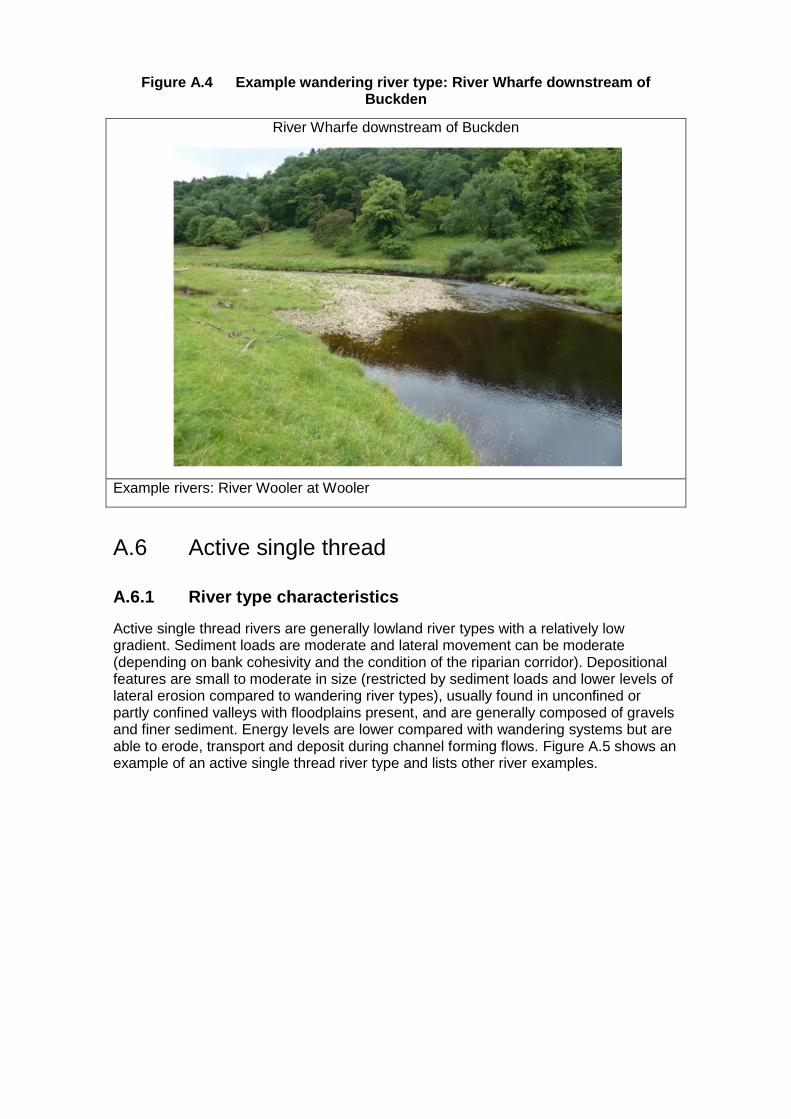
Figure A.4 Example wandering river type: River Wharfe downstream of Buckden
River Wharfe downstream of Buckden
Example rivers: River Wooler at Wooler
A.6 Active single thread
A.6.1 River type characteristics
Active single thread rivers are generally lowland river types with a relatively low gradient. Sediment loads are moderate and lateral movement can be moderate (depending on bank cohesivity and the condition of the riparian corridor). Depositional features are small to moderate in size (restricted by sediment loads and lower levels of lateral erosion compared to wandering river types), usually found in unconfined or partly confined valleys with floodplains present, and are generally composed of gravels and finer sediment. Energy levels are lower compared with wandering systems but are able to erode, transport and deposit during channel forming flows. Figure A.5 shows an example of an active single thread river type and lists other river examples.

Figure A.5 Example active single thread river type: River Medlock at Clayton Vale
River Medlock at Clayton Vale
Example rivers: River Trent at Catton Hall Estate, River Irwell at Prestolee Mill Weir
A.7 Passive single thread
A.7.1 River type characteristics
Passive single thread rivers are generally found in lowland areas with a low gradient. Sediment loads (particularly gravels) are lower and bed material is generally dominated by finer sediment (for example, sands and silts). Depositional (gravel) features are uncommon or poorly developed if present. The banks of the channel are often cohesive restricting lateral movement. Therefore, any available energy is often focused on the channel bed, leading to incised, deep channels with a poor connection to the floodplain. Bank protection may be artificially creating passive conditions by restricting lateral movement potential. Figure A.6 shows an example of a passive single thread river type and lists other river examples.

Figure A.6 Example passive single thread river type: River Swift at Rugby
River Swift at Rugby
Example rivers: Pent Stream at Folkestone, River Skerne at Darlington
A.8 Lowland anastomosed
A.8.1 River type characteristics
Lowland anastomosed rivers are found in lowland areas with low gradients. They develop a multi-thread channel network through stable islands, bars and berms and as a result of the formation and movement of LWD jams. Floodplain connectivity is good and different channels are activated at different flow levels, spreading flow energy over a wide area, creating stable channel conditions. Bed material is generally composed of fine sediment with some gravel exposed in locally energetic areas. Wet woodland often thrives in the riparian zone of this channel type due to the well-connected floodplain and the woodland often provides the lateral stability required for the functioning of this river type. Figure A.7 shows an example of a restored, lowland anastomosed river type and lists other river examples.

Figure A.7 Example lowland anastomosed river type: River Trent at Croxall Lakes
River Trent at Croxall Lakes (© Google Earth, GetMapping 2014)
Example rivers: Latchmore Brook in the New Forest just upstream of Ogdens, Bagshot Gutter in the New Forest at Minstead

Appendix B: Modelling approach
B.1 Digital Elevation Models
Existing national datasets were utilised to create a Digital Elevation Model (DEM) suitable for hydraulic habitat modelling. To ensure that channel geometry was included in the DEM, the supplied Digital Terrain Model (DTM) was modified to include river channel depth by using detailed aerial photography to supply bathymetry and field observations as a ‘sense check’.
The DEMs were created using LiDAR to define terrestrial topography, merged with red/green spectral analysis of available aerial imagery to define bathymetric topography. As LiDAR does not provide reliable elevation data beneath the water surface (the laser beams are absorbed by the water surface), the red/green spectral analysis was used to replace the LiDAR data across wet areas.
The technique has been used in previous shallow water coastal and riverine studies (Dierssen et al. 2003, Stumpf et al. 2003, Williams et al. 2011). It relies on the fact that spectral components of sunlight are differentially attenuated down the water column due to absorption and scattering. High energy blue light is absorbed quickly followed by green and then lower energy red light. Thus the ratio of two spectral bands (most commonly red/green to allow greater penetration) reflected from the submerged bed provides a measure of water depth. Spectral analysis on the DEMs used the Legleiter et al. (2004) relationship (Equation B.1) to derive the depth data (d) beneath the water surface for the study reach:
𝑑 = 𝑎 ln (𝐿𝑟𝑒𝑑
𝐿𝑔𝑟𝑒𝑒𝑛) (B.1)
where 𝑎 is a factor defined through a combination of empirical measurements and estimation based on independent depth data for each case study, Lred is the radiance value for red spectrum light and Lgreen is the radiance value for green spectrum light.
The LiDAR and aerial imagery derived datasets are produced in the same spatial referencing system so that they can be merged together to create a seamless DEM (Figure B.1).
Figure B.1 Example of a DEM model
Creation of a suitable DEM for the in-channel conditions also required filtering of elevation data linked to overhanging trees that obscured actual data for the channel bed beneath. During creation of the DEM, overhanging tree information was manually

identified through positive residuals above surrounding bank levels. Once identified, these areas were blanked out of the in-channel DEM due to the uncertainty regarding the bed elevations beneath.
Figure B.2 shows an example of an unrealistic blockage in the channel which has been removed through the method of interpolating between upstream and downstream to give a more suitable bed profile based on aerial imagery analysis.
Figure B.2 DTM editing analysis showing removal of tree shadowing effect from DTM
Notes: Bed levels interpolated due to spectrum analysis also being affected by trees.
B.2 Hydrodynamic modelling
The 2D hydraulic model JFLOW+ (Bradbrook 2006) was applied to the DEM and used to map the hydraulic habitat/biotopes present under low and bankfull conditions. Use of a fixed bed hydraulic model was deemed appropriate since the hydraulic habitat mapping was performed using a simulation of low flow conditions where the hydraulic forces operating are generally insufficient to cause bed or bank erosion or to transport gravel and cobble sized sediment. It solves depth averaged fluid flow equations to model the movement of water over the ground (Bradbrook 2006). Simulations across a range of low to high flow levels were used to calculate in-channel hydraulic parameters important for hydromorphological and ecological functioning and sediment transport (velocities, flow shear stresses, Froude numbers and flow depths).
The fixed bed model approach used assumes that no morphological change will occur during low flow conditions. This is not unreasonable as the hydraulic forces operating are generally insufficient to cause bed or bank erosion.

The hydraulic model is not a dynamic sediment model and changes to the channel form over time were not quantified. It is recognised that the restoration measures will be subject to higher flows which may alter the channel form and low flow hydraulics over time (see, for example: Newson et al. 2002, Gilvear et al. 2013). For example, the impacts of fine sediment management may be better demonstrated in a dynamic sediment model where sediment supply and loads can be quantified. The modelling of shear stress values was used to provide an indication of the restoration of riverine processes and potential for future channel adjustment.
For each case study, flow data for modelling were obtained from the nearest available gauging station scaled to the correct catchment area using Flood Estimation Handbook (FEH) methods (CEH 1999). The results were checked for sensibility through comparison with a LowFlows 2 derived estimate of Q95, a software package for estimating natural flows in ungauged catchments (WHS 2010).
B.2.1 Model outputs
The JFLOW+ hydrodynamic model generates two main outputs:
Hydraulic habitat/biotope distribution. This allows habitat distribution to be observed spatially. This spatial output allows an assessment of habitat connectivity and patchiness;
Shear stress distribution at bankfull conditions. This gives an indication of potential sediment transport and channel change (both in terms of erosion and deposition). This can indicate activation of the recovery of riverine processes and future channel change.
B.3 JHAB modelling
Compared with conventional methods, fuzzy logic allows for a better use of imprecise and uncertain measurements and vague expert knowledge in two ways:
the representation and handling of imprecise data as defined as fuzzy sets
the representation and processing of vague expert knowledge in the form of linguistic rules with imprecise terms defined as fuzzy rules
The fuzzy set theory (Zadeh 1965) is an extension of classic set theory. It is built around the central concept of fuzzy sets or membership functions. Fuzzy set theory enables the processing of imprecise information by means of membership functions, in contrast to Boolean characteristic mappings (Zadeh 1965). In conventional set theory, mapping of a classical set only takes two values: one, when an element belongs to the set; and zero, when it does not. In fuzzy set theory, an element can belong to a fuzzy set with its membership degree varying from zero to one (Adriaenssens et al. 2004).
The potential advantages of this method were highlighted by Schneider and Jorde (2003) as:
I. knowledge about habitat requirements is usually qualitative, but can be numerically processed by the fuzzy rule based approach
II. fuzzy logic calculations consider multivariate effects but no independence of the parameters is required
III. fuzzy rules use combinations of physical parameters as the input variable
IV. a comparatively small number of measured or observed data are needed
V. new parameters can be added easily

VI. because of the fuzziness, the demands upon the accuracy of the hydraulic calculations or observed physical parameters are lower than in conventional approaches
However, Schneider and Jorde (2003) did point out two potential limitations:
the number of fuzzy rules increase rapidly as more parameters are considered
the rules are so close to human language that they can give the false impression that they can be easily defined by persons regarding themselves as experts
B.3.1 Methodology
For this study the approach to habitat modelling is restricted to the consideration of depth and velocity. As the approach is 2-dimensional, this implicitly includes consideration of the wetted usable area, as nodes predicted as wet (depth > 0) and/or dry as a function of model solution.
Depth and velocity are both interpreted into 3 classes: poor, medium and good. Habitat is classified into 6 classes: unsuitable, very poor, poor, good, very good and excellent. Fuzzy subsets are then defined for depth (Di) and Velocity (Vi) that define the grade of membership of each predicted depth (d) or velocity (v) of each of the i (poor, medium or good) subsets:
(B.2)
where: p is poor, m is medium and g is good; and μLi(l) is the grade of membership of the predicted value l(d or v) in Li(Di or Vi), which equals one for at least one value of L for each i.
In this scheme, when 0 < μLi(l) <1, has a partial membership of Li, and this is the sense in which the analysis is fuzzy, with l potentially being a partial member of more than one Li. A fuzzy rule is then specified for habitat (Hk) based on 2 premises (for D and V):
If then Hk, for K values of k (B.3)
where K is the number of habitat classes, i is the subset of depth and j is the subset of velocity. In this case, i = j = 3, there are 9 rules and potentially 9 values of k.
To capture the fuzziness of the analysis, membership of Di and Vj is expressed as a grade which may vary between zero and one. Thus, a product operation rule is then used to define the degree of fulfilment of a particular habitat class:
(B.4)
1,0,;)(, dDdddD DpDpp
1,0,;)(, dDdddD DmDmm
1,0,;)(, dDdddD DgDgg
1,0,;)(, vVvvvV VpVpp
1,0,;)(, vVvvvV VmVmm
1,0,;)(, vVvvvV VgVgg
ji VD
)(,)(, vVjHkdDiHkHk

where, μHk is the degree of fulfilment of habitat class k, as defined by each possible combination of Di and Vj (from Equation B.2), given the predicted values of d and v.
The 9 rules can be used to provide 9 habitat classes. However, a symmetrical habitat classification is used, weighting D and V equally in the determination of habitat suitability (Table B.1). This could be made more sophisticated by changing the weightings to reflect the known importance of velocity and depth in contributing to a particular habitat class, possibly informed by field data or traditional habitat suitability analyses, or calibrated onto measured relationships between habitat and productivity for a specific reach or set of reaches.
Table B.1 Symmetrical definition of habitat classes in relation to the rule set defined in Equation B2
Velocity poor
(presence rarely found)
Velocity medium (presence sometimes
found)
Velocity good(presence
often found)
Depth poor (presence rarely
found)
Unsuitable habitat
0
Very poor habitat
1
Poor habitat
2
Depth medium (presence sometimes
found)
Very poor habitat
1
Good habitat
3
Very good habitat
4
Depth good(presence
often found)
Poor habitat
2
Very good habitat
4
Excellent habitat
5
The analysis so far provides 9 outcomes which indicate the degree of fulfilment of each rule. If there was no fuzziness in the system, then there would only be a single outcome. As the level of fuzziness increases, so the number of outcomes increases to the maximum of 9.
To provide a single habitat suitability index, the analysis is defuzzified to produce a single ‘crisp’ number. Two numbers are produced. The first number is a habitat suitability index and accounts for the total habitat available within a given reach. The second number is the habitat suitability index weighted by the area of habitat so as to provide a measure of habitat quality.
B.3.2 Fuzzy rules used
A literature review was performed to identify habitat preferences (Table B.2) and derive fuzzy rules (Table B.3).

Table B.2 Habitat preferences
Four different life stages of brown trout (Salmo trutta)
0+ that is, young of the year fish
1+ <20cm that is, juvenile fish
>20cm that is, adult fish
Spawning that is, requirements for spawning adults.
Sources: Heggenes (1989), De Crispin de Billy and Usseglio-Polatera (2002) Armstrong et al. (2003)
Cyprinid 0+ fish Only one cyprinid life stage is investigated, because there is less information available than for salmonids, and because adult cyprinids tend be generalists and are found in a wide range of habitats, more information is available for 0+ cyprinids (it is thought that recruitment from the 0+ life stage is a primary control on the year class strength) (see, for example: Mann 1995).
Refugia General rule for all fish species
The Environment Agency’s fish swimming speed research (Clough and Turnpenny 2001) was used as the basis for this rule.
The information set out in Table B.2 forms the ecological knowledge in the habitat model. The preferences are presented as fuzzy rules in Table B.3.
A graphical representation of the fuzzy rules for 0+ brown trout is provided in Figure B.1.
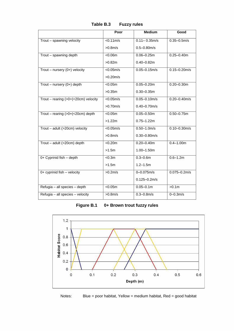
Table B.3 Fuzzy rules
Poor Medium Good
Trout – spawning velocity <0.11m/s
>0.8m/s
0.11– 0.35m/s
0.5–0.80m/s
0.35–0.5m/s
Trout – spawning depth <0.06m
>0.82m
0.06–0.25m
0.40–0.82m
0.25–0.40m
Trout – nursery (0+) velocity <0.05m/s
>0.20m/s
0.05–0.15m/s
0.15–0.20m/s
Trout – nursery (0+) depth <0.05m
>0.35m
0.05–0.20m
0.30–0.35m
0.20–0.30m
Trout – rearing (>0+(<20cm) velocity <0.05m/s
>0.70m/s
0.05–0.10m/s
0.40–0.70m/s
0.20–0.40m/s
Trout – rearing (>0+(<20cm) depth <0.05m
>1.22m
0.05–0.50m
0.75–1.22m
0.50–0.75m
Trout – adult (>20cm) velocity <0.05m/s
>0.8m/s
0.50–1.0m/s
0.30–0.80m/s
0.10–0.30m/s
Trout – adult (>20cm) depth <0.20m
>1.5m
0.20–0.40m
1.00–1.50m
0.4–1.00m
0+ Cyprinid fish – depth <0.3m
>1.5m
0.3–0.6m
1.2–1.5m
0.6–1.2m
0+ cyprinid fish – velocity >0.2m/s 0–0.075m/s
0.125–0.2m/s
0.075–0.2m/s
Refugia – all species – depth <0.05m 0.05–0.1m >0.1m
Refugia – all species – velocity >0.8m/s 0.3–0.8m/s 0–0.3m/s
Figure B.1 0+ Brown trout fuzzy rules
Notes: Blue = poor habitat, Yellow = medium habitat, Red = good habitat

B.3.3 Model outputs
The fuzzy logic habitat model generates three main outputs:
a habitat suitability index (HSI) for each cell. This is scored between zero and one. This allows habitat suitability to be observed spatially. This spatial output allows insight into interesting ecological questions such as habitat connectivity and patchiness.
a total habitat suitability index (THSI) value for the study reach (for each flow and species/life-stage of interest)
a measure of habitat quality (THSI divided by wetted area 100)

Appendix C: Additional information about the case studies Case study selection was based on the following constraints.
Restoration sites paired with suitable control sites where pre and post restoration data for the same reach were available, or where modifications to baseline data could be made easily to simulate post restoration conditions (for example, weir removal), were included.
Aerial imagery on Google Earth (both historic and current) was available. This was not the case for more recent restoration projects within the last 5 years.
Smaller restoration measures were excluded since some of the smaller restoration measures (for example, bank reprofiling and LWD) are poorly captured on some of the imagery and LiDAR due to the resolution needed for the modelling.
Restoration measures in wooded areas were excluded since tree cover obscures the watercourse impacting the aerial imagery and LiDAR data needed for the modelling.
Only river/reach/habitat (bar unit) scale restoration measures were considered as large scale (whole river/catchment) restoration measures require significantly larger amounts of data and time for data manipulation, and require a more complex modelling approach, which was beyond the scope of this project.
These selected schemes are listed in Table C.1 together with an indication of the available data and the confidence in that data.
Table C.1 Details of selected case studies
Restoration measure Data available Data confidence
River Wharfe, Upper Wharfedale
1
Assisted natural recovery – restoration of lateral erosive processes following bank protection failure in a wandering channel
LiDAR 1m resolution (1999 and 2009)
Flow data
Detailed aerial Photographs
JBA survey data
Good/moderate confidence with detailed LiDAR data and photographs
Uncertainty of deeper and shaded areas reduced by use of survey data to validate models.
Predicted shear stress values for bankfull conditions relate well to the size of material transported (mobile material seen on active gravel/cobble features) under elevated flow conditions and points where erosion is concentrated (that is, downstream of bend apices).
2 Flood bank removal in a wandering channel
Restoration measure Data available Data confidence
River Irwell, Prestolee Mill Weir
3 Weir removal in a meandering channel
LiDAR 2m resolution, 2003
LiDAR 1m resolution, 2009
Flow data
Google Earth aerial photographs (poor resolution)
Hydraulic flood model
JBA survey data and field observations
Survey data were available to validate and sense check the model outputs.
Hydraulic habitats, post weir removal, were checked against field observations.
Good confidence for a comparison at the reach scale, moderate confidence for finer bed detail and habitat patchiness.
Google Earth images were not sufficient resolution to be used.
Predicted shear stress values for bankfull conditions relate well to the size of material transported (mobile material seen on active gravel/cobble features) under elevated flow conditions.
River Skerne, Darlington
4 Re-meandering in a passive single thread river
LiDAR 2m resolution, 2000
LiDAR 1m resolution, 2008
Flow data
Google Earth aerial photographs (poor resolution)
Publications and monitoring reports
Moderate confidence
The models for this scheme are less accurate than for other schemes in this study due to poor quality aerial photographs and shading, but the low energy nature of the Skerne and the extensive monitoring and observations available were used to validate the models.
Shear stress predictions are within the range expected for a passive single thread system of this nature.
River Ribble, Long Preston Deeps SSSI
5
Palaeo channel reconnection in an active single thread river
LiDAR 1m resolution, 2004
LiDAR 1m resolution, 2009
Google Earth aerial photographs
Flow data
JBA survey data and field observations
Good confidence due to validation with survey data and field observations.
Pools depths were validated by survey data and Google Earth image analysis.
The maximum shear stress zones around the outside of meanders also compare well with zones of active bank erosion.
Notes: The LiDAR used included the highest resolution and most recent data in-filled with
composite LiDAR data where deeper areas have been filtered out of the original data.

Further information about the modelling of each case study and additional outputs not included within the main report are presented below.
C.1 Assisted natural recover in a wandering river
The River Wharfe at Upper Wharfedale is one of England’s most active gravel bed rivers and is considered to be a wandering river under natural conditions.
The confidence in the combination of LiDAR and aerial imagery to reproduce the bed geometry is good as a result of the aerial imagery resolution (and validated by a detailed understanding of site conditions). However, a lack of confidence is notable in the aerial imagery data for deeper pool areas around bends and areas where significant tree cover blocks part of the channels. Initial model simulations gave uncertainty in the representation of deeper pool features around the outside of meanders. This is where knowledge of the river was particularly useful as the outputs could be interpreted and checked for sensibility with additional adjustments to the DTM being made accordingly, in this case, bed lowering where deeper pools are known to be present.
Both bankfull flow (Q10–Q20) and Q95 low flow conditions were modelled for the River Wharfe. Bankfull flows were derived from iterative simulation of flows along the constrained reach. The suitable bankfull flow was then applied to the unconstrained/ naturalised reach. Low Q95 flows were derived from the nearest known flow gauge and scaled to the correct catchment area using Flood Estimation Hydrograph (FEH) methods (Kjeldsen et al. 2008).
Data from the Environment Agency gauging station on the River Wharfe at Addingham (SE0914649298), approximately 32km downstream of the study site, was used to calculate the discharges used in the modelling. The Environment Agency has confidence in the measured flows at both low and high flows at this station. The mean daily flow record for the gauging station was used to produce the flow duration curve. This was scaled by catchment area to produce a flow duration curve for the case study site (Table C.2). The discharges used in the high and low modelling were calculated from the flow duration curve.
Table C.2 Low flow calculation for River Wharfe study sites
Addingham Study site
Catchment area (km2) 427 68
Exceedance probability Flow (m3/s) Flow (m3/s)
5 52.0 8.3
10 35.8 5.7
50 6.8 1.1
70 4.0 0.6
80 3.0 0.5
90 2.1 0.3
95 1.8 0.3
The comparison of shear stress variability under constrained and naturalising conditions for bankfull flows is shown in Figure C.1. The modelling shows a greater diversity around and across gravel bar features that have formed in the channel,

picking the higher energy zones within the thalweg – a line drawn to join the lowest points along the entire length of a stream bed defining its deepest channel.
The shear stress values around the outside of the most upstream meander may be inaccurate due to the presence of vegetation across the channel margin impacting the aerial imagery returns data and possible strong recirculatory currents around this particular bend. The influence of the upstream flow route across the floodplain may also be impacting the flow processes around this bend. The scale of shear stress in this wandering river case study highlights the fact that significant lateral erosion could be expected once constraints to lateral processes have been removed.
Figure C.1 Sheer stress variability under high flows; River Wharfe
Study reach shear stress variability at bankfull flow (Q10–Q20)
Control reach shear stress variability at bankfull flow (Q10–Q20)
The habitat suitability distribution for adult trout and flow refugia under high flows are presented in Section 4 of the main report. In addition, the habitat suitability for 0+ trout and trout spawning were assessed (Figure C.2).
A comparison of the distribution of this habitat provision shows that, within the restored section, good quality 1+ habitat can be observed at the apex of meander bends and in the upper reaches of the site. Good quality spawning habitat is associated with the faster flowing water.
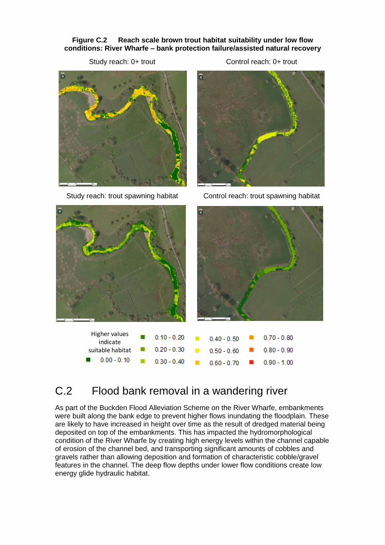
Figure C.2 Reach scale brown trout habitat suitability under low flow conditions: River Wharfe – bank protection failure/assisted natural recovery
Study reach: 0+ trout Control reach: 0+ trout
Study reach: trout spawning habitat Control reach: trout spawning habitat
C.2 Flood bank removal in a wandering river
As part of the Buckden Flood Alleviation Scheme on the River Wharfe, embankments were built along the bank edge to prevent higher flows inundating the floodplain. These are likely to have increased in height over time as the result of dredged material being deposited on top of the embankments. This has impacted the hydromorphological condition of the River Wharfe by creating high energy levels within the channel capable of erosion of the channel bed, and transporting significant amounts of cobbles and gravels rather than allowing deposition and formation of characteristic cobble/gravel features in the channel. The deep flow depths under lower flow conditions create low energy glide hydraulic habitat.
Higher values indicate
suitable habitat

The length of embankment immediately downstream of Buckden Bridge (length of ~190m) on the left bank of the channel was selected as the example site for embankment removal and thus improved floodplain reconnection (Error! Reference source not found.C.3). The same discharges were used in this case study as for the first case study.
Figure C.3 Reach modelled for simulated flood bank removal
Notes: The embankment is indicated by the box. Contains Ordnance Survey data © Crown copyright and database right 2014
The historic straightening and bank protection measures along this reach maintain high energy levels under bankfull flows for post removal conditions as seen in the shear stress outputs (Error! Reference source not found.C.4). Removal of the embankments, reinstatement of some of the lost channel length or removal of the existing bank protection would allow lateral erosive processes to re-meander naturally. This would reduce shear stress values under bankfull conditions and influence the morphology of the channel to a greater extent than just embankment removal.
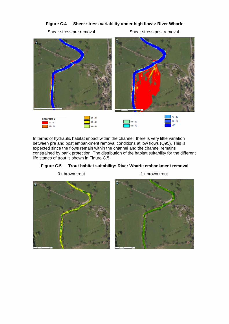
Figure C.4 Sheer stress variability under high flows: River Wharfe
Shear stress pre removal Shear stress post removal
In terms of hydraulic habitat impact within the channel, there is very little variation between pre and post embankment removal conditions at low flows (Q95). This is expected since the flows remain within the channel and the channel remains constrained by bank protection. The distribution of the habitat suitability for the different life stages of trout is shown in Figure C.5.
Figure C.5 Trout habitat suitability: River Wharfe embankment removal
0+ brown trout 1+ brown trout

Adult brown trout Brown trout spawning
The effects of the embankment removal on habitat availability were only seen under bankfull conditions. An assessment of the availability of refugia habitat (Figure C.6) shows a substantial increase in refugia habitat as the water moves onto the floodplain.
Figure C.6 Refugia habitat suitability: Rive Wharfe embankment removal
Refugia: pre removal Refugia: post removal
Higher values indicate
suitable habitat
Higher values indicate
suitable habitat
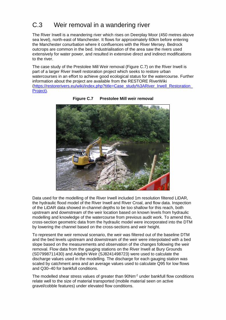
C.3 Weir removal in a wandering river
The River Irwell is a meandering river which rises on Deerplay Moor (450 metres above sea level), north-east of Manchester. It flows for approximately 60km before entering the Manchester conurbation where it confluences with the River Mersey. Bedrock outcrops are common in the bed. Industrialisation of the area saw the rivers used extensively for water power, and resulted in extensive direct and indirect modifications to the river.
The case study of the Prestolee Mill Weir removal (Figure C.7) on the River Irwell is part of a larger River Irwell restoration project which seeks to restore urban watercourses in an effort to achieve good ecological status for the watercourse. Further information about the project are available from the RESTORE RiverWiki (https://restorerivers.eu/wiki/index.php?title=Case_study%3ARiver_Irwell_Restoration_Project).
Figure C.7 Prestolee Mill weir removal
Data used for the modelling of the River Irwell included 1m resolution filtered LiDAR, the hydraulic flood model of the River Irwell and River Croal, and flow data. Inspection of the LiDAR data showed in-channel depths to be too shallow for this reach, both upstream and downstream of the weir location based on known levels from hydraulic modelling and knowledge of the watercourse from previous audit work. To amend this, cross-section geometric data from the hydraulic model were incorporated into the DTM by lowering the channel based on the cross-sections and weir height.
To represent the weir removal scenario, the weir was filtered out of the baseline DTM and the bed levels upstream and downstream of the weir were interpolated with a bed slope based on the measurements and observation of the changes following the weir removal. Flow data from the gauging stations on the River Irwell at Bury Grounds (SD7998711430) and Adelphi Weir (SJ8241498723) were used to calculate the discharge values used in the modelling. The discharge for each gauging station was scaled by catchment area and an average values used to calculate Q95 for low flows and Q30–40 for bankfull conditions.
The modelled shear stress values of greater than 90Nm-2 under bankfull flow conditions relate well to the size of material transported (mobile material seen on active gravel/cobble features) under elevated flow conditions.
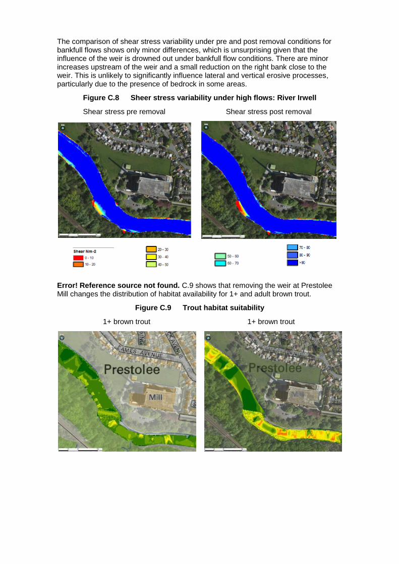
The comparison of shear stress variability under pre and post removal conditions for bankfull flows shows only minor differences, which is unsurprising given that the influence of the weir is drowned out under bankfull flow conditions. There are minor increases upstream of the weir and a small reduction on the right bank close to the weir. This is unlikely to significantly influence lateral and vertical erosive processes, particularly due to the presence of bedrock in some areas.
Figure C.8 Sheer stress variability under high flows: River Irwell
Shear stress pre removal Shear stress post removal
Error! Reference source not found. C.9 shows that removing the weir at Prestolee Mill changes the distribution of habitat availability for 1+ and adult brown trout.
Figure C.9 Trout habitat suitability
1+ brown trout 1+ brown trout

Adult brown trout Brown trout spawning
Both before and after weir removal, refugia habitat was available at the margins of the channel and immediately downstream of the weir on the left hand bank (Figure C.10). There was little change in the availability of refugia as a result of the weir’s removal.
Figure C.10 Refugia habitat suitability: River Irwell
Refugia: pre removal Refugia: post removal
Higher values indicate
suitable habitat
Higher values indicate
suitable habitat

C.4 Re-meandering of a passive single thread river
The River Skerne was part of a joint project between England and Denmark to demonstrate best practice in urban and rural river rehabilitation and promote river restoration across Europe. The wider aim was to demonstrate how river restoration could provide multiple benefits such as enhancement in wildlife, landscape, recreation, water quality, fisheries, amenities and other local interest.
The restoration of 2km of the Skerne began in July 1995 (Figure C.11). Restoration opportunities were severely limited since much of the floodplain had been raised by old industrial waste tipping and gas and sewer pipes ran alongside the river. Four new meanders were cut across the old channel, creating backwaters, at the upstream end, instream deflectors and a coarse sediment riffle were installed to enhance flow variability and habitat diversity. Soft revetments – such as willow mattress, willow spiling, underwater rock layer, fibre rolls, and geotextiles were used on the outer meander bends to prevent erosion towards the gas main. To aid flood water retention about 25,000m3 of spoil was removed from the river banks and used for landscaping. Further details of the project can be found on the RESTORE RiverWiki (https://restorerivers.eu/wiki/index.php?title=Case_study%3ARiver_Skerne-_Life_project) or the RRC’s ‘Manual of River Restoration Techniques’ (http://www.therrc.co.uk/sites/default/files/projects/p1525.pdf).
Figure C.11 Aerial view of the Skerne restoration scheme
Data available for the River Skerne at Darlington included flow gauge data and 2m resolution filtered LiDAR of the reach post re-meandering works. No detailed aerial photography was available for the site. To represent the pre restored channel, the bed levels and channel width from upstream and downstream of the restored section were interpolated to provide a suitable gradient and uniform channel profile. Reference was also made to the 1945 Google Earth aerial imagery. The results were compared with published information about the scheme (Aberg and Tapsell, 2013 and RRC, 2013).
The flow duration curve for the gauging station on the River Skerne at South Park (NZ2840712910) was scaled by catchment area to produce a flow duration curve for the case study site (Table C.3). The flow duration curve was used to calculate the Q95 and bankfull flows derived from iterative simulation of flows along the constrained reach. The suitable bankfull flow was then applied to the reach where the palaeo channel was reconnected (Q20–Q30).

Table C.3 Flow calculation for River Skerne site
South Park Study site
Catchment area (km2) 250 204
Exceedance probability Flow (m3/s) Flow (m3/s)
5 5.27 4.30
10 3.25 2.65
50 0.91 0.74
70 0.66 0.53
80 0.54 0.44
90 0.42 0.34
95 0.37 0.30
The channel hydraulic habitat was dominated by pools both before and after restoration. Assessment of the in-channel shear stress showed values of 0.3–1.2Nm-2 under bankfull flows (Figure C.12), which are likely to promote fine sediment deposition for both pre and post restoration conditions.
Figure C.12 Sheer stress variability under high flows: River Skerne
Shear stress pre removal Shear stress post removal
The change in the habitat suitability for the different brown trout life stages following restoration is shown in Figures C.13 and C.14.

Figure C.13 Habitat suitability for 0+ and 1+ brown trout
0+ brown trout 0+ brown trout
1+ brown trout 1+ brown trout
Higher values indicate
suitable habitat

Figure C.14 Habitat suitability for adult brown trout and brown trout spawning
Adult brown trout Adult brown trout
Brown trout spawning Brown trout spawning
C.5 Palaeo channel reconnection in an active single thread river
The Long Preston Floodplain Project was launched in 2004 with the aim of improving the wildlife value of the Ribble floodplain between Settle, Long Preston and Wigglesworth. The project area covers 765ha. The main aims of the project are to:
restore wetland habitats
boost populations of existing wetland wildlife
attract back species that have been lost
Further details of the project can be found at: http://longprestonfloodplainproject.org/longpreston.php
Higher values indicate
suitable habitat

Data available for the River Ribble at the Long Preston Deeps SSSI included 1m resolution filtered LiDAR, flow gauge data and Goggle Earth imagery. The overall confidence in the model DTM and model outputs for the River Ribble is good because the model and outputs were validated by local survey information undertaken by JBA geomorphologists. To represent the restored palaeo channel, the embankment in the DEM was modified based on design information for the restoration scheme.
The flow duration curve for Arnford Weir (SD8386155586) was scaled by catchment area to produce a flow duration curve for the case study site (Table C.4). The Q95 was used for the low flow discharge. Bankfull flows were derived from iterative simulation of flows along the constrained reach and applied to the same reach with the palaeo channel reconnected at the upstream end (Q10–Q30).
Table C.4 Low flow calculation for River Ribble site
Arnford Weir Study site
Catchment area (km2) 204 147
Exceedance probability Flow (m3/s) Flow (m3/s)
5 30.00 21.63
10 20.40 14.71
50 3.06 2.21
70 1.52 1.10
80 1.04 0.75
90 0.64 0.46
95 0.46 0.33
The habitat suitability under low flow conditions did not vary since the flow remains within the channel and the channel has not had time to adjust since the measures were implemented. The distribution of the habitat suitability for the different life stages of trout is shown in Figure C.15.
Figure C.15 Trout habitat suitability: River Ribble
0+ brown trout 1+ brown trout

Adult brown trout Brown trout spawning
The effects of the palaeo channel reconnection on habitat availability were seen only under bankfull conditions. An assessment of the availability of refugia habitat showed little change when considering the channel only. However, when the floodplain is included, an increase in refugia habitat is seen on the floodplain (Figure C.16).
Figure C.16 Refugia habitat suitability: River Ribble
Refugia: pre removal Refugia: post removal
Higher values indicate
suitable habitat
Higher values indicate
suitable habitat

Appendix D: Literature review Table D.1 presents a summary of the main findings of the review of literature and case studies carried out for this project.
The watercourse considered in each source was allocated to a river type. Since the information provided in each source varied, a measure of confidence (high, medium or low) was applied to the river type.
The restoration measure used in each source was allocated to one of the categories considered in the review (Table 3.1, Figure 3.1).
The results and conclusions were reviewed for the effectiveness of a low flow hydromorphic impact (low flow refuges), low flow ecological impacts and high flow refuges. Both positive and negative impacts were considered.

Table D.1 Review of river restoration literature for this project
+/- impact +/- impact +/- impact
1
Abbe, T.B. and Montgomery, D.R., 1996. Large woody
debris jams, channel hydraulics and habitat formation in
large rivers. Regulated Rivers: Research Management ,
12 (2-3), 201-221.
Islands and multi-thread networks form in response to debris
jams. Change in channel topography and surface textures
directly affect the quality of aquatic and terrestrial riparian habitat
- pools, bars and islands. Creation and stabilisation of pool
refugia. Paper presents results from pool-riffle reaches.
Queets River,
Washington stateActive single thread M
16 - Large woody material (LWM) and flow
deflectors+ Improved habitat diversity +
Increased habitat diversity ,
creation of pool refugia+ Improved habitat diversity
2
Archer, D. and Newson, M., 2002. The use of indices of
flow variability in assessing the hydrological and
instream habitat impacts of upland afforestation and
drainage. Journal of Hydrology , 268 (1-4), 244-258.
Impact of closed canopy development, flow pulses decreased,
less flashy, links initial flashiness. Low invertebrate numbers
and low levels of fish recruitment may be party attributed to
changes in the flow regime.
Coalburn catchment Bed rock, step-pool M 2 - Planting native woodland and trees ? ? + Reduced peakiness
3
Besacier-Monbertrand, A.-L., Paillex, A. and Castella, E.,
2014. Short-term impacts of lateral hydrological
connectivity restoration on aquatic macroinvertebrates.
River Research Applications,30 (5), 557-570.
Excavation and restoration of connectivity and flow in secondary
channels. In the reconnected channel, lateral connectivity
increased and remained high 5 years after restoration. The
macroinvertebrate composition and the rarefied Ephemeroptera,
Plecoptera and Trichoptera (EPT) richness changes were
proportionally related to the changes in lateral connectivity. Alien
species richness and densities increased progressively in all
channels after restoration. Results showed that modifications of
the lateral connectivity lead to predictable changes in
macroinvertebrate diversity.
Upper-Rhône River Lowland anatomosed M4 - Improved floodplain connectivity
(including floodbank removal)-
No evidence of improved
habitat under low flows-
No evidence of improved
ecology in low flows+ Increased connectivity
4
Buchanan, B.P., Walter, M.T., Nagle, G.N. and
Schneider, R.L., 2012. Monitoring and assessment of a
river restoration project in central New York. River
Research and Applications , 28 (2), 216-233.
Project engineers classified the creek as an F4 stream,
transitioning to C4 in the lower reaches (Rosgen Level II) (IRS
2004). Assessment and monitoring documented substantial
planform and profile instabilities in the first 2 years following
construction. Assessment parameters indicated that aquatic
habitat was enhanced and that the outlook for future habitat
creation and maintenance was favourable. The outlook for
improved instream habitat was also favourable. Restoration
measures may have actually compromised short-term channel
stability.
Six Mile Creek, New
York state Wandering L
16 - Large woody material (LWM) and flow
deflectors+ Improved habitat diversity ? Not considered within study +
Channel more stable at high
flows - increased refugia
5
Buijse, A.D., Coops, H., Staras, M., Jans, L.H., Van
Geest, G.J., Grift, R.E., Ibelings, B.W., Oosterberg, W.
and Roozen, F.C.J.M., 2002. Restoration strategies for
river floodplains along large lowland rivers in Europe.
Freshwater Biology , 47 (4), 889-907.
Restoration strategies for river floodplains along large lowland
rivers in Europe. Rehabilitation projects need to focus primarily
on the transition zones and distant wetland habitats. Many river
and floodplain restoration projects in the past lacked a sound
scientific underpinning. More recent projects are being
increasingly conceived as meso- to macro-scale scientific
experiments designed to document the success or failure of
restoration measures.
Rhine/DanubeActive single thread
lowland anastomosingM
4 - Improved floodplain connectivity
(including floodbank removal)? ? + High flow benefits
6
Clilverd, H.M., Thompson, J.R., Heppell, C.M., Sayer,
C.D. and Axmacher, J.C., 2013. River-floodplain
hydrology of an embanked lowland Chalk river and initial
response to embankment removal. Hydrological
Sciences Journal , 58 (3), 627-650.
River–floodplain hydrology of an embanked lowland Chalk river
and initial response to embankment removal. Embankment
removal has reduced the channel capacity by an average of
60% facilitating overbank flow which is likely to favour conditions
for improved flood storage and removal of river nutrients by
floodplain sediments.
River Glavern Passive single thread H5 - Improved floodplain connectivity
(including floodbank removal)-
No evidence of improved
habitat under low flows-
No evidence of improved
ecology in low flows+
Increased flood plain
connectivity at high flows,
increase in refugia
7
Davidson, S.L. and Eaton, B.C., 2013. Modelling channel
morphodynamic response to variations in large wood:
Implications for stream rehabilitation in degraded
watersheds. Geomorphology , 202, 59–73.
LWM significantly decreased the reach-averaged velocity in all
experiments, and was associated with decreased sediment
transport and increased sediment storage. Adding wood
increased pool frequency, variability in cross-sectional depth
and transition from a plane-bed to a riffle-pool morphology.
Retention of fine sediment increased the availability of fish
spawning substrate. Increased water stage improved
connectivity between the channel and the floodplain. Changes in
habitat complexity were associated with wood load, but also
depended on the orientation and arrangement.
Experiments Experiment N/A16 - Large woody material (LWM) and flow
deflectors+ Improved habitat diversity ?
Improved spawning habitat
and diversity+
Increased habitat diversity at
high flows
WatercourseNotes on the project Watercourse type Restoration measureReferenceConfidence
in type
Bankfull flow hydromorphicLow flow hydromorphic Low flow ecology

+/- impact +/- impact +/- impact
8 - Bank reprofiling/ protection removal
16 - Large woody material (LWM) and flow
deflectors
9
Downward, S. and Skinner, K., 2005. Working rivers: the
geomorphological legacy of English freshwater mills.
Area , 37 (2), 138-147.
Weir removal reinstates natural processes on most river types
depending on the scale and size of the weir and backwater
length.
Various Most types H13 - Barrier removal (for example, weirs,
dams, sluices)+
Improved habitat diversity -
reduced impoundment+
Improved habitat diversity -
reduced impoundment+
Improved habitat diversity -
reduced impoundment
10
Endreny, T.A. and Soulman, M.M., 2011. Hydraulic
analysis of river training cross-vanes as part of post-
restoration monitoring. Hydrology and Earth System
Sciences , 15 (7), 2119-2126.
Restoration to reduce bank erosion and downstream turbidity.
Assessment of (i) natural channel design cross-vanes used to
reduce erosion in a riffle-pool design in a mountainous region
where the step-pool planform may be more stable and (ii) of not
adequately establishing bank protection with vegetation and
strategically placed river training structures.
Batavia Kill, Catskill
Mountains, New York
state
Step-pool M16 - Large woody material (LWM) and flow
deflectors-
Channel not stable - step-
pool would have been more
appropriate design.
-
Channel not stable - step-
pool would have been more
appropriate design.
-
Channel not stable - step-
pool would have been more
appropriate design.
11
Environment Agency, 2005. Gravel reworking to restore
a low flow channel . River Darent, Hawley Manor, Kent.
Unpublished [See also
www.therrc.co.uk/MOT/Final_Versions_(Secure)/5.8_Ha
wley_Manor.pdf]
Berm creation and channel narrowing to rehabilitate a section of
the Darent in Kent that improved spawning ground and
hydromorphic conditions in the short term.
River Darent Passive single thread H15 - Berm creation (including planting of
vegetation)+ Increased habitat diversity + Increased habitat diversity +
Increased habitat diversity at
high flows
3 - Fine sediment measures including
riparian management+ Increased habitat diversity + Interaction with vegetation + Increased habitat diversity
11 - Gravel addition or reprofiling, riffles or
bars- Not long term sustainable -
Short term improvements
but not long term sustainable- Not long term sustainable
14 - Barrier management (for example,
weirs, dams, sluices)+ Increased habitat diversity + Increased habitat diversity + Increased habitat diversity
13
Florsheim, J.L. and Mount, J.F., 2002. Restoration of
floodplain topography by sand-splay complex formation
in response to intentional levee breaches, Lower
Cosumnes River, California. Geomorphology , 44 (1-2),
67-94.
Use of sand splay complexes to restore multi-thread floodplain
systems in California. Need to consider catchment context
when undertaking restoration work.
Lower Cosumnes
RiverLowland anatomosed M
4 - Improved floodplain connectivity
(including floodbank removal)+ Increased habitat diversity + Increased habitat diversity +
Increased habitat diversity
and connectivity at high flows
14
Gumiero, B., Mant, J., Hein, T., Elso, J. and Boz, B.,
2013. Linking the restoration of rivers and riparian
zones/wetlands in Europe: sharing knowledge through
case studies. Ecological Engineering , 56, 36-50.
A variety of case studies across Europe - interaction with
floodplains and benefits of reconnecting. Flood management is
one of the most powerful drivers in determining the future
functioning of floodplain areas.
Various across Europe
Wandering, active
single thread, passive
single thread, lowland
anatomosing
M4 - Improved floodplain connectivity
(including floodbank removal)+
Some evidence of
geomorphic processes
improving
+
Some case studies showed
improved ecology in low
flows
+ Improvements at high flows
4 - Improved floodplain connectivity
(including floodbank removal)
11 - Gravel addition or reprofiling, riffles or
bars
Reference Notes on the project Watercourse Watercourse type
Bear Creek Meadow,
California
Montane meadow positive impacts of improved floodplain
connectivity on riparian condition. Hydrological responses: (1)
increased groundwater levels and volume of subsurface
storage; (2) increased frequency/duration of floodplain
inundation and decreased magnitude of flood peaks; and (3)
decreased annual runoff and duration of baseflow. ‘Pond and
plug’ type stream restoration projects have the capacity to re-
establish the hydrological processes necessary to sustain
riparian systems.
L
8 Active single threadRiver Idle
Increase in scour around bends as a result of bank and bend
reprofiling on the River Idle. Restoration is not possible -
rehabilitation is. Hydraulic modelling of flood conveyance
indicated enhancement measures resulted in a loss of
conveyance of only about 10% at flows approaching the bankfull
stage. Hydraulic variability increased around installed riffles and
deflectors, areas of deposition added morphological diversity
and provided areas of plant colonisation. Fishy fry utilise
backwaters.
M
?
Hammersmark, C.T., Rains, M.C. and Mount, J.E., 2008.
Quantifying the hydrological effects of stream restoration
in a Montane meadow, northern California, USA. River
Research and Applications , 24 (6), 735-753.
Downs, P.W. and Thorne, C.R., 1998. Design principles
and suitability testing for rehabilitation in a flood defence
channel: the River Idle, Nottinghamshire, UK. Aquatic
Conservation-Marine and Freshwater Ecosystems , 8
(1), 17–38.
M
Confidence
in typeRestoration measure
? +Increased flood plain
connectivity at high flows
Low flow hydromorphic Low flow ecology Bankfull flow hydromorphic
+Increased habitat diversity at
high flows? Not considered ? Not considered
12Active single thread,
passive single thread
Riparian buffer zones reduced fine sediment entry, and nutrient
and pesticide inflows; and positive effects on stream organisms
were evident. Buffer width and length were critical: 5–30m width
and >1 km length were most effective. Instream measures
(large woody debris, boulders and gravel): the potential positive
effects of such local habitat enhancement schemes were often
likely to be swamped by larger scale geomorphological and
physicochemical effects with few studies demonstrating long-
term biological recovery. Weir removal can have clear beneficial
effects, although biological recovery might lag behind for several
years, as huge amounts of fine sediment may have
accumulated upstream of the former barrier.
Feld, C.K., Birk, S., Bradley, D.C., Hering, D., Kail, J.,
Marzin, A. and Friberg, N., 2011. Chapter Three – From
natural to degraded rivers and back again: a test of
restoration ecology theory and practice. In Advances in
Ecological Research, Volume 44 (ed. G. Woodward),
pp. 119-209. Waltham, MA: Academic Press.
15
Various
Wandering

+/- impact +/- impact +/- impact
16
Harper, D., Ebrahimnezhad, M. and Cot, F.C.I., 1998.
Artificial riffles in river rehabilitation: Setting the goals and
measuring the successes. Aquatic Conservation:
Marine and Freshwater Ecosystems , 8 (1), 5-16.
Gravel introduction as riffles with correct spacing and depth can
provide functional habitat in lowland rivers with low energy.
Riffle reinstatement will produce desirable geomorphological
and ecological changes if the riffles are spaced according to
geomorphological ‘first principles’ and are shallow (<30cm
deep) under low flow conditions.
River Nene Passive single thread M11 - Gravel addition or reprofiling, riffles or
bars+ Increased physical diversity +
Change in invertebrate
community+
High flows needed to
maintain integrity.
17
Holden, J., 2009. A grip-blocking overview [online].
Upland Hydrology Group paper. School of Geography,
University of Leeds. Available from:
http://www.uplandhydrology.org.uk/wp-
content/uploads/2013/12/Holden-2009-grip-block-
review.pdf
Overview of research on grip blocking - most work
concentrates on water quality changes.Various Various L 1 - Grip blocking ? ? + Limited evidence
18
Jeffries R., Darby S.E. and Sear D. A., 2003. The
influence of vegetation and organic debris on flood-plain
sediment dynamics: case study of a low-order stream in
the New Forest. Geomorphology , 51 (1-3), 61-80.
Woody debris jams on low order streams in the New Forest
help maintain multi-thread system characteristics. In-channel
debris dams locally increase the frequency and extent of
overbank flows; the impact of such dam on floodplain
sedimentation was observed. The highly variable pattern of
accretion can be explained by the combined effects of
topography and organic material present on the surface of the
floodplain.
Highland Water, New
Forest
Active single thread,
lowland anatomosedM
16 - Large woody material (LWM) and flow
deflectors+ Increased habitat diversity ? Not considered +
Increased connectivity,
restored physical processes
and increased diversity
19JBA, 2011. Croxall Lakes channel widening
assessment. Unpublished
Islands were created as part of restoration works on the River
Trent at Croxall and Catton which improved gravel bed condition
and reduced incision.
River Trent Active single thread H 9 - Channel widening + Increased habitat diversity ? Interaction with vegetation + Increased connectivity
20JBA, 2012a. River Restoration Plan development for the
River Ribble Long Preston Deeps SSSI. Unpublished
Floodbank realignment improved connectivity and allowed gravel
bed recovery in the Ribble at Long Preston Deeps SSSI.River Ribble
Wandering, Active
single threadH
4 - Improved floodplain connectivity
(including floodbank removal)+ Increased habitat diversity + Increased habitat diversity +
Increased habitat diversity at
high flows, increase in refugia
15 - Berm creation (including planting of
vegetation)+ Increased habitat diversity + Increased habitat diversity +
Increased habitat diversity at
high flows, increase in refugia
13 - Barrier removal (for example, weirs,
dams, sluices)+ Increased habitat diversity + Increased habitat diversity +
Increased habitat diversity at
high flows
10 - Channel narrowing, 2-stage channel +Increased physical
processes reducing
siltation and increasing
+ Increased habitat diversity +Increased habitat diversity at
high flows
13 - Barrier removal (for example, weirs,
dams, sluices)+
Increased connectivity,
restored physical
processes and increased
+ Increased connectivity + Increased connectivity
23JBA, 2012d. River Nar Hydromorphological Assessment
for proposed river restoration measures. Unpublished
River Nar LWM features successful in providing localised
hydromorphic variability.River Lark and Nar Passive single thread H
16 - Large woody material (LWM) and flow
deflectors+ Increased habitat diversity ? Not reported within study +
Increased habitat diversity at
high flows
24
JBA, 2012-13. River restoration design for reconnection
of a palaeo channel on the River Ecclesbourne, Duffield.
Unpublished
Palaeo reconnection to bypass weir has resulted in quick gravel
bed recovery.River Ecclesbourne Active single thread H
7 - Re-meandering, palaeo channel
reconnection+ Increased habitat diversity ? Not considered + Increased connectivity
25JBA, 2012-14a. Unpublished audits of New Forest rivers
and streams
Restoration plan development for 50+ SSSI sites within the New
Forest
New Forest rivers and
streams
Active single thread,
lowland anatomosedH 2 - Planting native woodland and trees + Increased habitat diversity + Interaction with vegetation + Increased habitat diversity
26JBA, 2012-14b. Restoration plan development for 50+
SSSI sites within the New Forest. Unpublished
Unpublished audits of New Forest rivers and streams indicated
historic tree clearance had resulted in single thread system
creation, compared with natural anastomosed systems that rely
on forested areas for supply of LWM and bank reinforcement to
promote multi-thread flow.
New Forest rivers and
streams
Active single thread,
lowland anatomosedH
16 - Large woody material (LWM) and flow
deflectors+ Increased habitat diversity ? Not reported within study +
Increased habitat diversity at
high flows
Modelling of removal of embankments at Buckden on the
Wharfe showed some hydromorphic improvement at high flows
but limited at low flows due to banks protection.
4 - Improved floodplain connectivity
(including floodbank removal)-
No impact since bank
protection limited
geomorphic processes
-
No impact since bank
protection limited
geomorphic processes
+
Increased flood plain
connectivity at high flows,
increase in refugia
Modelling for this project and audit work have demonstrated
improved hydromorphology where natural recovery has
occurred compared with reaches where it has not.
5 - Assisted natural recovery / cessation of
active management+ Increased habitat diversity + Increased habitat diversity +
Increased flood plain
connectivity at high flows,
increase in refugia
Bankfull flow hydromorphicReference Notes on the project Watercourse Watercourse type
H
H
HWandering
Confidence
in typeRestoration measure
Low flow hydromorphic Low flow ecology
Passive single thread
JBA, 2012b. Flood and restoration management plan for
the Pent Stream (Unpublished report for the
Environment Agency)
Channel narrowing and 2-stage channel creation improved
habitat diversity. Weir removal as part of restoration works
resulted in a reduced deposition of fine sediment.
Pent Stream Passive single thread21
JBA, 2014a. Modelling undertaken for this project.
UnpublishedRiver Wharfe
Pent Stream
JBA, 2012c. Flood and restoration management plan for
the Pent Stream (Unpublished report for the
Environment Agency)
Weir removal as part of restoration works on the Pent Stream
resulted in reduced deposition of fine sediment.
27
22

+/- impact +/- impact +/- impact
28JBA, 2014b. Modelling undertaken for this project.
Unpublished
Modelling for this project has shown little impact on
hydromorphic processes and condition as a result of re-
meandering on the Skerne at Darlington.
River Skerne Passive single thread H7 - Re-meandering, palaeo channel
reconnection-
No improvement in low flow
habitat conditions-
No improvement in low flow
habitat conditions?
Minor improvement in flow
refugia
29JBA, 2014c. Modelling undertaken for this project.
Unpublished
Modelling of a section of the Wharfe that has outflanked old bank
protection has shown significant hydromorphic improvement
and recovery as a result of reinstatement of lateral processes.
Wharfe Wandering H 8 - Bank reprofiling/ protection removal + Increased habitat diversity + Increased habitat diversity +
Increased flood plain
connectivity at high flows,
increase in refugia
30
Kennedy, R.J., Johnston, P. and Allen, M., 2014.
Assessment of a catchment wide salmon habitat
rehabilitation scheme on a drained river system in
Northern Ireland. Fisheries Management and Ecology ,
21 (4), 275-287.
Habitat suitability for juvenile salmon increased. Significant
changes in underlying physical habitat characteristics (particle
size, depth and flow) were detected after the installation of flow
deflectors. Salmon fry recruitment index - no change between
pre- and post-enhancement periods. Mean biomass of salmon
significantly higher at enhancement than control sites. Increased
densities of >0+ juvenile salmon at enhanced sites relative to
controls. Details of river type unclear.
River Main, Northern
IrelandPassive single thread L
16 - Large woody material (LWM) and flow
deflectors+
Increase in habitat suitability
for salmonid fish+ Increased habitat diversity + Increased habitat diversity
31Kondolf, G.M., 2006. River restoration and meanders.
Ecology and Society , 11, (2), 42.
Channel reconstruction projects often have the objective of
creating a stable, single-thread, meandering channel, even on
rivers that were not historically meandering, on rivers whose
sediment load and flow regime would not be consistent with
such stable channels, or on already sinuous channels whose
bends are not symmetrical. Rosgen classification system, a
popular restoration design approach. Completed post project
appraisals show that many of these projects failed within
months or years of construction. Failure of several re-
meandering projects as a result of not understanding river
processes.
Various Anastomosing M7 - Re-meandering, palaeo channel
reconnection- Unsustainable - Unsustainable - Unsustainable
7 - Re-meandering, palaeo channel
reconnection
11 - Gravel addition or reprofiling, riffles or
bars
33
Kristensen, P.B., Kristensen, E.A., Riis, T., Baisner, A
J., Larsen, S.E., Verdonschot, P F.M. and Baattrup-
Pedersen, A., 2013. Riparian forest as a management
tool for moderating future thermal conditions of lowland
temperate streams. Hydrology Earth System Sciences
Discussions , 10, 6081-6106.
Riparian forest as a management tool for moderating future
thermal conditions of lowland temperate streams. Consideration
of the length of forest. Small tributaries.
Five small Danish
lowland streams
Active single thread,
passive single threadL 2 - Planting native woodland and trees -
Channel widening - no
evidence improved low flow
habitat
?
Cooler temperatures but
physical changes not
considered.
? No discussed
34
Kristensen, E.A., Kronvang, B., Wiberg-Larsen, P.,
Thodsen, H., Nielsen, C., Amor, E., Friberg, N.,
Pedersen, M.L. and Baattrup-Pedersen, A., 2014. 10
years after the largest river restoration project in Europe:
hydromorphological changes on multiple scales in River
Skjern. Ecological Engineering , 66, 141-149.
In-stream habitats changed little over the past 10 years, still
resembling habitats immediately after the restoration.
Measurements of channel stability showed that erosion and
sedimentation have changed the cross-sectional profiles over
the last 10 years, resulting in a net input of sediment to the lower
reaches of the river. However, the change of channel form was
a slow process and predicted bank retreat over a 100-year
period was only up to 6.8m. Hence the formation of lost habitats
(islands, backwaters and oxbow lakes) is a very slow process
and the spontaneous development of these habitats will take
centuries.
Skjern Passive single thread L 6 - Moving whole planform -
Slow recovery due to loss
of channel forming peak
flows
? Not reported within study +Reconnection with flood plain
and so increased refugia
35
Large, A.R. and Petts, G.E., 1996. Historical channel-
floodplain dynamics along the River Trent. Applied
Geography , 16 (3), 191-209.
Study identified embankment removal and improved floodplain
connectivity as a suitable restoration measure.River Trent Active single thread H
4 - Improved floodplain connectivity
(including floodbank removal)+ Increased habitat diversity + Increased habitat diversity +
Increased flood plain
connectivity at high flows,
increase in refugia
Reference Notes on the project Watercourse Watercourse typeConfidence
in typeRestoration measure
Low flow hydromorphic Low flow ecology Bankfull flow hydromorphic
Restoration success often
limited, partly because the
restorations have been
conducted without due
regard to characteristics
specific to the river type
? ?LActive single thread,
passive single thread
Various (54 Danish
streams, 10
Lithuanian)
32 ?
Restoration success often
limited, partly because the
restorations have been
conducted without due regard
to characteristics specific to
the river
Restoration success often
limited, partly because the
restorations have been
conducted without due
regard to characteristics
specific to the river type
Restoration success has often been limited, partly because the
restorations have been conducted without due regard to
characteristics specific to the river type. The physical condition
of restored streams compared with that of near natural streams
(least disturbed condition) and channelised streams. Results
revealed that restorations have created physical conditions that
do not resemble characteristics specific to the river type,
primarily due to the addition of large amounts of coarse
substrate. Observations of physical condition in nearby
reference streams may be used to advantage in future
restoration planning. 54 streams from geological source
material areas.
Kristensen, P.B., Baattrup-Pedersen, A. and Thodsen
H., 2011. An evaluation of restoration practises in
lowland streams: has physical integrity been re-created?
Ecological Engineering , 37 (11), 1654-1660.

+/- impact +/- impact +/- impact
36
Lüderitz, V., Speierl, T., Langheinrich, U., Völkl, W. and
Gersberg, R.M., 2011. Restoration of the Upper Main
and Rodach rivers - the success and its measurement.
Ecological Engineering , 37 (12), 2044–2055.
8km length of palaeo channels restored, improved
hydromorphic condition and biological improvement. Multimetric
assessment found a clear success of restoration indicated by
the status of hydromorphology and by the biological parameters,
including macroinvertebrates, fishes and macrophytes. Unlike
non-restored reaches, the restored reaches attained a good
ecological status.
Main and Rodach
rivers,
Wandering, active
single threadL
7 - Re-meandering, palaeo channel
reconnection+
Sustained improvement in
habitats+
Ecological benefits for
invertebrates and fish+ Increased connectivity
11 - Gravel addition or reprofiling, riffles or
bars?
Short-term habitat diversity
increase - long-term
sustainability questioned
?
Short-term habitat diversity
increase - long-term
sustainability questioned
?
Short-term habitat diversity
increase - long-term
sustainability questioned
17 - Boulder clusters ?
Short-term habitat diversity
increase - long-term
sustainability questioned
?
Short-term habitat diversity
increase - long-term
sustainability questioned
?
Short-term habitat diversity
increase - long-term
sustainability questioned
38
Newson, M.D., 2002. Geomorphological concepts and
tools for sustainable river ecosystem management.
Aquatic Conservation: Marine and Freshwater
Ecosystems , 12 (4), 365-379.
Natural recovery, as a tool for river condition improvement for
geomorphological and ecological condition, can be appropriate
across most river types.
Various
Bedrock, step-pool,
plane-bed, wandering,
active single thread,
passive single thread,
lowland anatomosing
M5 - Assisted natural recovery / cessation of
active management? ? +
Increased flood plain
connectivity at high flows,
increase in refugia
39
Pander, J. Müller, M. and Geist, J,. 2015. Succession of
fish diversity after reconnecting a large floodplain to the
upper Danube River. Ecological Engineering , 75, 41-50.
Creation of new secondary floodplain channel. Restoration-
induced changes in habitat morphology and availability of habitat
space, a very fast initial colonisation was observed.
Danube Lowland anatomosed H7 - Re-meandering, palaeo channel
reconnection+ Increased habitat diversity + Increased habitat diversity +
Increased flood plain
connectivity at high flows,
increase in refugia
40
Pedersen, M.L, Friberg, N., Skriver, J., Baattrup-
Pedersen, A. and Larsen, S.E., 2007. Restoration of
Skjern River and its valley ‒ short-term effects on river
habitats, macrophytes and macroinvertebrates.
Ecological Engineering , 30 (1), 145-156.
Morphological adjustments were evident in the re-meandered
river and the habitat structure (depth, current velocity and
substratum) became more diverse. Initial instability associated
with re-meandering of the river masks some of the effects of the
restoration. Morphological adjustments in the new re-
meandered channel have increased short-term sediment
mobilisation. Biological communities will continue to develop
over the coming years as the river becomes more physically
stable. Hence the macroinvertebrate and macrophyte
communities will adjust and colonisation from upstream
sources and other systems will probably increase biodiversity.
Skjern Passive single thread L 6 - Moving whole planform + Increased habitat diversity + Increased habitat diversity + Increased habitat diversity
41
Pedersen, M.L. Kristensen, E.A., Kronvang, B. and
Thodsen, H., 2009. Ecological effects of re-introduction
of salmonid spawning gravel in lowland Danish streams.
River Research Applications , 25 (5), 626-638.
Gravel reintroduction as a long-term salmonid rehabilitation
method in 32 lowland streams. Downstream displacement of
gravel was most common at sites where gravel was
reintroduced without further improvement, although these sites
exhibited the highest density of young-of-the-year brown trout
(Salmo trutta ), evidencing that the remaining gravel is still
functional. The intensive study of 3 streams showed that
spawning was enhanced by the introduction of spawning gravel
at the restored sites compared with control sites and that habitat
quality generally were improved. Details of river types not
provided.
Various
Active single thread,
passive single thread,
lowland anatomosing
L11 - Gravel addition or reprofiling, riffles or
bars?
Some gravel movement -
habitats at low flows not
considered
?
Some gravel movement -
ecology at low flows not
considered
?
Some gravel movement -
some examples may not be
sustainable at high flows
Reference Notes on the project Watercourse Watercourse type
37
Müller, M. Pander, J. and Geist, J., 2014. The ecological
value of stream restoration measures: an evaluation on
ecosystem and target species scales. Ecological
Engineering , 62, 29-139.
LActive single thread,
passive single thread,
6 German headwater
streams
Evaluated two types of gravel introduction, substratum raking
and the placement of boulders in 6 streams. Six headwater
streams with differing morphology, fluvial dynamics and bedrock
geology (3 calcareous and 3 siliceous). Gravel introduction had
the strongest effects on macroinvertebrates (increase of
species density and numbers of individuals), periphyton
(increase of cell numbers) and macrophytes (decrease of
coverage, species numbers and biomass), followed by
substratum raking. The placement of boulders had no significant
long-term effects on aquatic communities. Overall investigated
restoration treatments: fish community composition only
changed significantly in 50% of the study rivers depending on
the occurrence of species sensitive to the structures introduced
by the restoration treatments. The results suggest that in-
stream restoration measures can contribute to freshwater
biodiversity conservation, but reproductive success of species
depending on long-term improvement of interstitial water quality
cannot be achieved without considering catchment effects and
natural substratum dynamics.
Confidence
in typeRestoration measure
Low flow hydromorphic Low flow ecology Bankfull flow hydromorphic
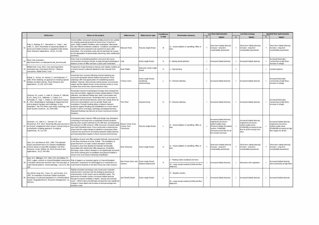
+/- impact +/- impact +/- impact
42
Pulg, U., Barlaup, B.T., Sternecker, K., Trepl, L. and
Unfer, G., 2013. Restoration of spawning habitats of
brown trout (Salmo trutta) in a regulated chalk stream.
River Research Applications , 29 (2), 172-182.
Gravel addition and gravel cleaning initially proved to be suitable
for creating spawning grounds for brown trout. In the first 2
years, highly suitable conditions were maintained. Afterwards,
the sites offered moderate conditions. Conditions unsuitable for
reproduction were expected to be reached 5-6 years after
restoration. The restoration works did not eliminate the causes
for the degradation of gravel banks (damming, bank stabilisation
and fines).
Moosach River Passive single thread M11 - Gravel addition or reprofiling, riffles or
bars?
Short-term habitat diversity
increase - long-term
sustainability questioned
?
Short-term habitat diversity
increase - long-term
sustainability questioned
?
Short-term habitat diversity
increase - long-term
sustainability questioned
43River Cole restoration -
http://www.therrc.co.uk/projects/cole_brochure.pdf
River Cole re-meandering planform and some old course
reconnection increased number of expected geomorphological
features in form of riffles and bars 3 years post restoration.
Cole Active single thread H 6 - Moving whole planform + Increased habitat diversity + Increased habitat diversity +
Increased flood plain
connectivity at high flows,
increase in refugia
44
Ribble River Trust, 2012. Cam and Gayle Beck
restoration trial. Final report 2011/12 . Clitheroe,
Lancashire: Ribble Rivers Trust.
Programme of grip blocking to improve river habitat condition as
a result of excess sediment delivered to the channels from
grips.
River RibbleStep-pool, active single
threadH 1 - Grip blocking ? ? + Limited evidence
45
Rohde, S., Schütz, M., Kienast, F. and Englmaier, P.,
2005. River widening: an approach to restoring riparian
habitats and plant species. River Research and
Applications , 21 (10), 1075-1094.
Gravel bed river recovery following channel widening was
successful alongside riparian habitat improvement. River
widenings offer real opportunities for establishing riparian
habitats. However, they promote mainly pioneer successional
stages and the habitat mosaic of the restored section is more
complex than at the near-natural reference sites.
3 Swiss rivers
Active single thread,
wandering,
anastomosing
L 9 - Channel widening + Increased habitat diversity + Increased habitat diversity +
Increased flood plain
connectivity at high flows,
increase in refugia
46
Schirmer, M., Luster, J., Linde, N., Perona, P., Mitchell,
E.A.D., Barry, D.A., Hollender, J., Cirpka, O.A.,
Schneider, P., Vogt, T., Radny, D. and Durisch-Kaiser,
E., 2014. Morphological, hydrological, biogeochemical
and ecological changes and challenges in river
restoration – the Thur River case study, Hydrology and
Earth System Sciences , 18, 2449-2462.
Restoration induced morphological changes that reshaped the
river bed and banks, triggered complex spatial patterns of bank
infiltration, and affected habitat type, biotic communities and
biogeochemical processes. Restoration led to an increase in
taxonomic and functional diversity, which was mainly driven by
short-term perturbations such as periodic floods and
inundations. Periodic flooding allows a balance between
protection against flooding and rehabilitation to a more natural
system in terms of ecology, hydrology and biogeochemistry.
Repeated flooding may become an issue if excessive erosion
threatens.
Thur River Anastomosing H 9 - Channel widening + Increased habitat diversity + Increased habitat diversity +
Increased flood plain
connectivity at high flows,
increase in refugia
47
Schwartz, J.S., Neff, K.J., Dworak, F.E. and
Woockman, R.R. 2014. Restoring riffle-pool structure in
an incised, straightened urban stream channel using an
ecohydraulic modeling approach. Ecological
Engineering , 78, 112-126.
Constrained urban channel. Riffle-pool design was developed
consisting of removing trees at expanded channel locations,
placing 3.8cm gravel substrate for the riffle bed, and deepening
the pool prior to riffle entrance. Riffle structures remained stable
even with 8 bankfull events. Post-construction monitoring has
shown that the unique design for planform-constrained urban
channels has promise for increasing hydraulic habitat diversity
and improving biotic integrity in these stressed environments.
Beaver Creek, Knox
County, East
Tennessee
Passive single thread L11 - Gravel addition or reprofiling, riffles or
bars+
Increased habitat diversity,
engineered structures -
wetted usable areas
(Physical Habitat Simulation
System, PHABSIM)
increased at low flow for all
fish except rock bass
+
Increased habitat diversity,
engineered structures -
wetted usable areas
(PHABSIM) increased at low
flow for all fish except rock
bass
+
Increased habitat diversity,
engineered structures -
wetted usable areas
(PHABSIM) increased at high
flow stages for all fish
48
Sear, D.A. and Newson, M.D., 2004. The hydraulic
impact and performance of a lowland rehabilitation
scheme based on pool-riffle installation: the River
Waveney, Scole, Suffolk, UK. River Research and
Applications , 20 (7), 847-863.
Installation of pools and riffles provided hydraulic improvements
to the River Waveney at Scole, Suffolk. The installation of
gravel bed forms on water surface elevations and flow
resistance show they display the hydraulic functionality
associated with natural pool–riffle sequences. At bankfull
discharge, water surface elevation is not significantly increased
over those existing prior to installation and physical habitat is
shown to be more diverse following rehabilitation.
River Waveney Active single thread H11 - Gravel addition or reprofiling, riffles or
bars?
Short-term habitat diversity
increase - long-term
sustainability questioned
?
Short-term habitat diversity
increase - long-term
sustainability questioned
?
Short-term habitat diversity
increase - long-term
sustainability questioned
2 - Planting native woodland and trees
16 - Large woody material (LWM) and flow
deflectors
17 - Boulder clusters
16 - Large woody material (LWM) and flow
deflectors
Reference Notes on the project Watercourse Watercourse type
50 Joe Farrell’s Brook + Increased habitat diversity Active single thread L
49
+ Increased habitat diversity
Role of logjams as important agents of channel:floodplain
interaction. Importance of LWM (logjams) in maintenance of
multi-channel networks in the New Forest low order streams.
Confidence
in typeRestoration measure
Low flow hydromorphic Low flow ecology Bankfull flow hydromorphic
+
Van Zyll De Jong, M.C., Cowx, I.G. and Scruton, D.A.,
1997. An evaluation of instream habitat restoration
techniques on salmonid populations in a Newfoundland
stream. Regulated Rivers: Research Management , 13,
603-614.
Habitat restoration techniques and construction materials
selected were consistent with the biological and physical
characteristics of the stream and its identified needs. The
placement of boulder clusters increased habitat diversity
through increased variability in depths, velocity and instream
cover. LWM (V-dam and half logs) showed the most significant
change in mean depth and increase in pool percentage and
instream cover.
Sear, D.A., Millington, C.E., Kitts, D.R. and Jeffries, R.,
2010. Logjam controls on channel:floodplain interactions
in wooded catchments and their role in the formation of
multi-channel patterns. Geomorphology , 116 (3-4), 305-
319.
Interaction with vegetationActive single thread,
lowland anatomosedH
Increased habitat diversity
Increased habitat diversity
and connectivity at high flows
New Forest rivers and
streams ++ Increased habitat diversity +

15 of 15
www.gov.uk/environment-agency
Recommended